indian union states/territories and election sys
67
-
Upload
malik-rules -
Category
Education
-
view
2.684 -
download
0
Transcript of indian union states/territories and election sys

INDIAN UNION STATESAND ELECTION SYS


AIM
To Brief Offrs About The Indian Union
States/Territories and Election Sys
4

SEQ
Stage – I
Indian Union States
Indian Union Territories
Stage – II
Indian Election Sys
5

6
7
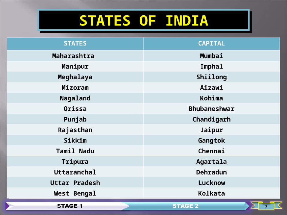
STATES OF INDIASTATES CAPITAL
Andhra Pradesh HyderabadArunachal Pradesh Itangar
Assam DispurBihar Patna
Chhattisgarh RaipurGoa Panaji
Gujarat GandhinagarHaryana Chandigarh
Himachal Pradesh ShimlaJammu & Kashmir Srinagar & Jammu
Jharkhand RanchiKarnataka Bangalore
Kerala ThiruvananthapuramMadhya Pradesh Bhopal
STATES CAPITAL
Maharashtra MumbaiManipur Imphal
Meghalaya ShiilongMizoram AizawiNagaland Kohima
Orissa BhubaneshwarPunjab Chandigarh
Rajasthan JaipurSikkim Gangtok
Tamil Nadu ChennaiTripura Agartala
Uttaranchal DehradunUttar Pradesh LucknowWest Bengal Kolkata
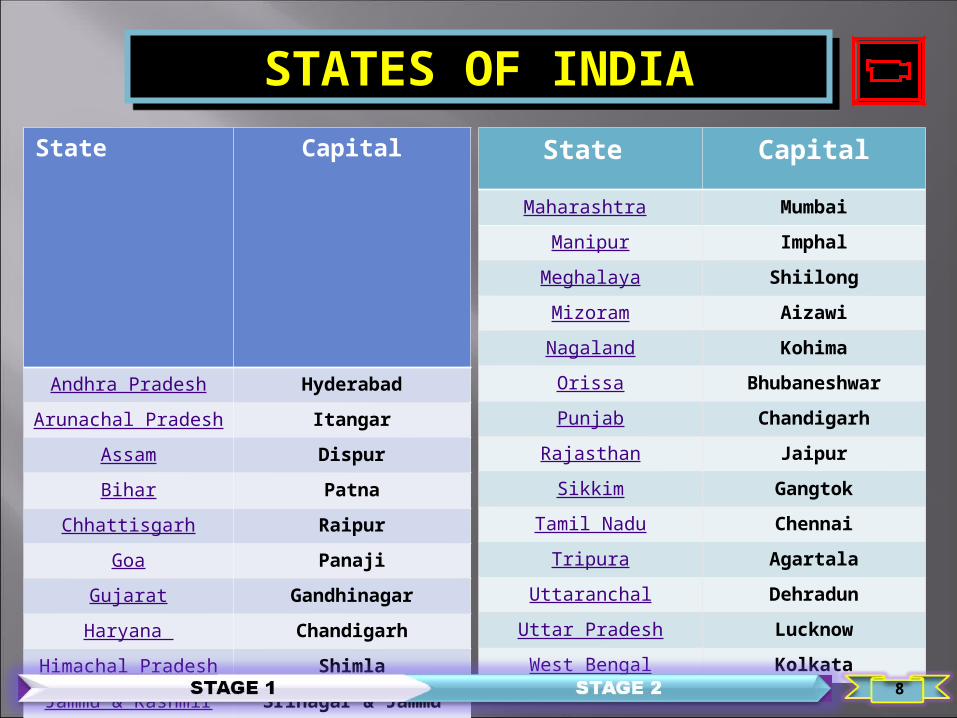
State
Capital
Andhra Pradesh HyderabadArunachal Pradesh Itangar
Assam DispurBihar Patna
Chhattisgarh RaipurGoa Panaji
Gujarat GandhinagarHaryana Chandigarh
Himachal Pradesh ShimlaJammu & Kashmir Srinagar & Jammu
Jharkhand RanchiKarnataka Bangalore
Kerala Thiruvananthapuram
Madhya Pradesh Bhopal
State Capital
Maharashtra MumbaiManipur Imphal
Meghalaya ShiilongMizoram AizawiNagaland Kohima
Orissa BhubaneshwarPunjab Chandigarh
Rajasthan JaipurSikkim Gangtok
Tamil Nadu ChennaiTripura Agartala
Uttaranchal DehradunUttar Pradesh LucknowWest Bengal Kolkata
STATES OF INDIA
8
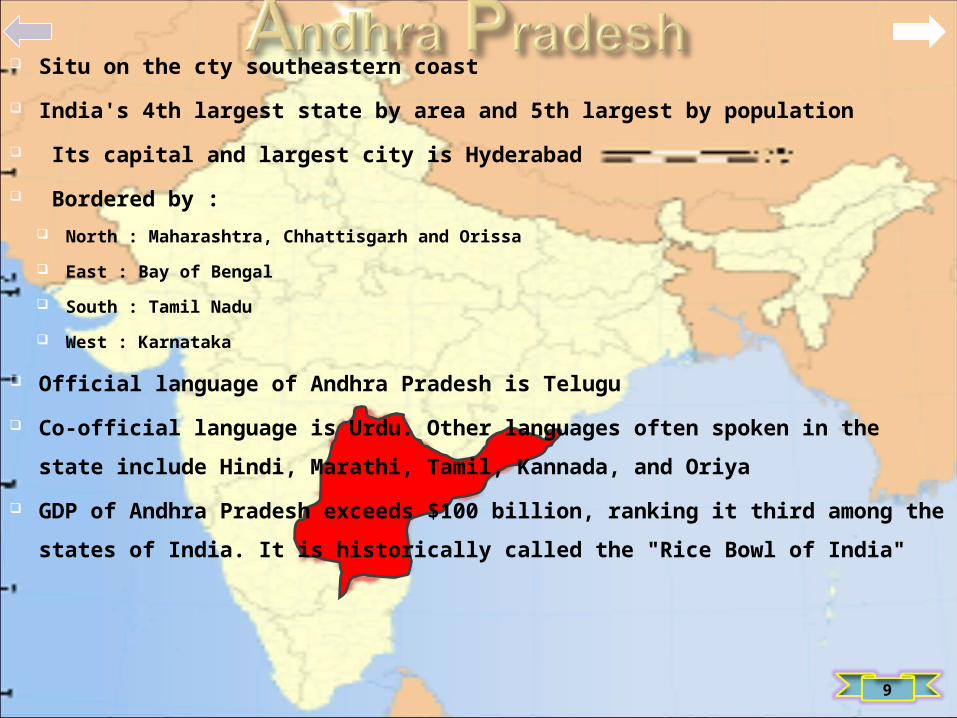
Situ on the cty southeastern coast
India's 4th largest state by area and 5th largest by population
Its capital and largest city is Hyderabad
Bordered by : North : Maharashtra, Chhattisgarh and Orissa
East : Bay of Bengal
South : Tamil Nadu
West : Karnataka
Official language of Andhra Pradesh is Telugu
Co-official language is Urdu. Other languages often spoken in the state include
Hindi, Marathi, Tamil, Kannada, and Oriya
GDP of Andhra Pradesh exceeds $100 billion, ranking it third among the states of
India. It is historically called the "Rice Bowl of India"
9

Loc in northeast India
Borders : South : states of Assam and Nagaland.
West : shares international borders with Bhutan
East : Burma
North : People's Republic of China (PRC)
Capital is Itanagar
Much of Arunachal Pradesh is covered by the Himalayas
lowest elevations, essentially at Arunachal Pradesh's border with Assam, are
Brahmaputra Valley semi-evergreen forests
In 2006 Bumla pass in Tawang was opened to traders for the first time in 44 years
GDP for 2004 was estimated at $706 million
10

Dispur is the capital of Assam
Assam is located south of the eastern Himalayas. Assam comprises the
Brahmaputra and the Barak river valleys along with the Karbi Anglong and
the Dima Hasao district with an area of 30,285 square miles (78,440 km²)
It is surrounded by 6 of the other States: Arunachal Pradesh, Nagaland, Manipur, Mizoram, Tripura, Meghalaya
It also shares intl borders with Bhutan and Bangladesh
Famous for its natural beauty
The landscape includes : Tea gardens, River Brahmaputra, Many Historical Monuments and Temples
11

It is a state in eastern India and Patna is capital of Bihar
12th largest state in terms of geo size at (98,940 km²)
3rd largest by population
Almost 58% of in Bihar are below the age of 25, which is the highest proportion in India
It lies mid-way btw West Bengal in the east and Uttar Pradesh in the west
It is bounded by the country: North : Nepal
South : Jharkhand
Plains are divided into two parts by the river Ganga which flows through the middle from
west to east
Forest area of 6,764.14 km²,which is 6.8% of its geo area
12

It is a state in Central India
Formed on Nov 1, 2000 by partitioning 16 Chhattisgarhi-speaking southeastern dist of Madhya Pradesh
Raipur is the capital of Chhattisgarh
It is the 10th largest state in India, with an area of 135,190 km²
It ranks as the 16th most-populated state of the nation
Electricity and Steel-producing state of India
State accounts for 15% of the total steel production of the cty
Borders the states of : Madhya Pradesh in the northwest, Maharashtra in the west, Andhra Pradesh in the south, Orissa in the east, Jharkhand in the
northeast and Uttar Pradesh in the north
13

India's smallest state by area and 4th smallest by population
Panaji is the state's capital
Vasco da Gama is the largest city
Loc in West India in the region known as the Konkan
bounded by the states of : North : Maharashtra
East/South : Karnataka to the east and south
Western Coast : Arabian Sea
Richest state with a GDP 2.5 that of the country as a whole Ranked the best placed state by the 11th Finance Commission for its infrastructure
Ranked on top for the best quality of life in India by the National Commission
Renowned for its beaches, places of worship and world heritage architecture
14

It is in western India
It has an : Area(196,030 km²)
Coastline of 1,600 km
Population in excess of 60 million
The state is bordered by : North : Rajasthan
South : Maharashtra
East : Madhya Pradesh
West : Arabian Sea as well as the Pak province of Sindh
Capital is Gandhinagar Largest city is Ahmedabad. Gujarat is home to the Gujarati-speaking people of India
The state has major sites of the ancient Indus Valley Civilization Lothal and Dholavira. Lothal is believed to be one of the world's first ports
15

State was constituted in 1966, it is one of two newly created states carved out of
the greater Punjab province as a means of creating a stronger national identity
Bordered by : North : Punjab and Himachal Pradesh
West and South : Rajasthan
River Yamuna defines its eastern border with Uttarakhand and Uttar Pradesh.
Haryana also surrounds Delhi on three sides, forming the northern, western and
southern borders of Delhi Capital of the state is Chandigarh which is administered as a union territory and is also the capital of
Punjab
Haryana is one of the wealthiest states of India and has the third highest per capita
income in the cty
16
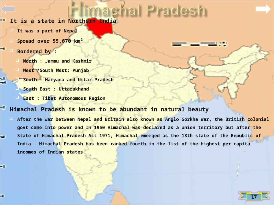
It is a state in Northern India It was a part of Nepal
Spread over 55,670 km²
Bordered by : North : Jammu and Kashmir
West /South West: Punjab
South : Haryana and Uttar Pradesh
South East : Uttarakhand
East : Tibet Autonomous Region
Himachal Pradesh is known to be abundant in natural beauty After the war between Nepal and Britain also known as Anglo Gorkha War, the British colonial govt came into
power and In 1950 Himachal was declared as a union territory but after the State of Himachal Pradesh Act
1971, Himachal emerged as the 18th state of the Republic of India . Himachal Pradesh has been ranked fourth
in the list of the highest per capita incomes of Indian states
17

It is the northern most state of India
It is situ mostly in the Himalayan mountains
Shares a border with the states of : South : Himachal Pradesh and Punjab
North/East : Internationally with the People's Republic of China
West/North West : Pak-adm territories of Azad Kashmir and Gilgit–Baltistan, to the west and
northwest respectively
Jammu and Kashmir consists of three regions : Jammu
The Kashmir valley
Ladakh
Kashmir valley is famous for its beautiful mountainous landscape
18

It is a state in eastern India. It was carved out of the southern part of Bihar on 15
Nov 2000
It shares its border with the states of : North : Bihar
West : Uttar Pradesh and Chhattisgarh
South : Orissa
East : West Bengal
It has an area of 79,714 km²
Industrial city of Ranchi is its capital Dumka is sub capital
Jamshedpur is the largest and the biggest industrial city of the state
19

It is a state in South West India Capital and largest city is Bangalore
Karnataka is bordered by : West : Arabian Sea
North West : Goa
North : Maharashtra
East : Andhra Pradesh
South East :Tamil Nadu
South West : Kerala
The state covers an area of 191,976 sq km 5.83% of the total geo area of India. It is the 8th largest Indian state by area
With over 61 million inhabitants , Karnataka is the 9th largest state by population, comprising 30 dist
Kannada is the most widely spoken and official language of the state
About 38,724 km² of Karnataka is covered by forests
20

It is loc on the Malabar coast of south-west India
The state has : an area of 38,863 km²
Bordered by :
North/North East : Karnataka
East / South : Tamil Nadu
West : Arabian Sea
Thiru-vanantha-puram is the state capital. Kochi, the financial & Industrial hub
Kerala stands unique among the Indian states with the highest Human Dev Index in
India, comparable with that of many dev ctys
With 93.91% literacy, the state is the most literate in India. A survey conducted in
2005 by Transparency Inttl ranked Kerala as the least corrupt state in the cty
21

Madhya Pradesh is often called the Heart of India
It is a state in central India Its capital is Bhopal and the largest city is Indore
Madhya Pradesh is the 2nd largest state by area
75 million population makes it sixth largest state in India
It borders the states of : North East : Uttar Pradesh
South East : Chhattisgarh
South : Maharashtra
West : Gujarat
North West : Rajasthan
22

It is the 2nd most populous state after Uttar Pradesh 3rd largest state by area in India
It is the richest state in India, contributing 15% of the country's industrial output and
13.3% of its GDP.
Bordered by : West : Arabian Sea
North West : Gujarat and the Union territory of Dadra and Nagar Haveli
North East : Madhya Pradesh
East : Chhattisgarh
South : Karnataka
South East : Andhra Pradesh
South West : Goa
The state covers an area of 307,731 Mumbai, the capital city of the state, is India's
largest city
23
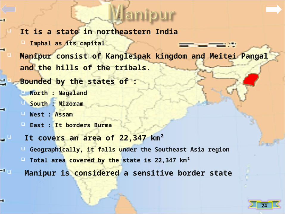
It is a state in northeastern India Imphal as its capital
Manipur consist of Kangleipak kingdom and Meitei Pangal and the hills of the tribals.
Bounded by the states of : North : Nagaland South : Mizoram West : Assam East : It borders Burma
It covers an area of 22,347 km² Geographically, it falls under the Southeast Asia region Total area covered by the state is 22,347 km²
Manipur is considered a sensitive border state
24

It is a hilly strip in the eastern part of the country about 300 km long
(east-west) and 100 km wide, with a total area of about 22,720 km²
The population numbered 21,75,000 in 2000
The state is bounded: North : Assam
South : Bangladesh
The capital is Shillong also known as the Scotland of the East, which
has a population of 260,000
About one third of the state is forested
The forests of Meghalaya are notable for their bio diversity of
mammals, birds, and plants
25
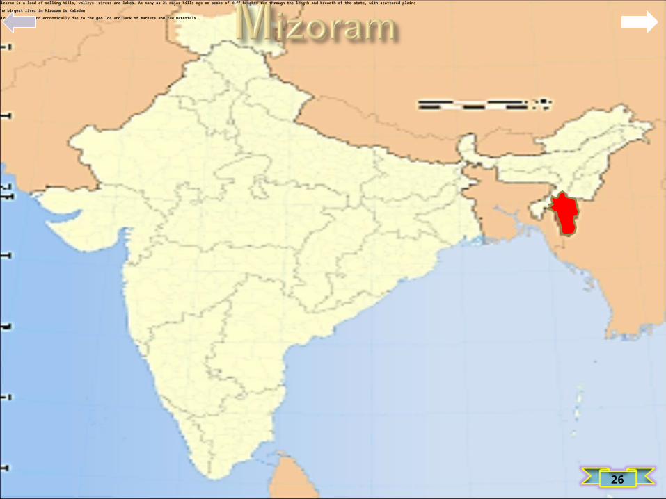
It is one of the Seven Sister States listed as in North Eastern India, sharing borders with the states of Tripura, Assam, Manipur and with the neighboring countries of Bangladesh and Myanmar Burma
Mizoram became the 23rd state of India on 20 Feb 1987
Its capital is Aizawl. Mizoram is loc in the northeast of India
Mizoram is a land of rolling hills, valleys, rivers and lakes. As many as 21 major hills rgs or peaks of diff heights run through the length and breadth of the state, with scattered plains
The biggest river in Mizoram is Kaladan
Mizoram lags behind economically due to the geo loc and lack of markets and raw materials
26

Nagaland is a state in the far north-eastern part of India
It borders the state of : West : Assam
North : Arunachal Pradesh and part of Assam
East : Burma
South : Manipur
The state capital is Kohima, and the largest city is Dimapur
The state of Nagaland has an area of 16,579 km² with a population of
1,980,602 as per the 2011 census making it one of the smallest states of India
The state is mostly mtns except those areas bordering Assam valley
27

Orissa is loc on the east coast of India, by the Bay of Bengal
Bhubaneswar is the capital of Orissa, and home to nearly a thousand temples
The modern state of Orissa was estb on 1 April 1936, as a province in British India Consisted predominantly of Oriya speakers
Orissa is the 9th largest state by area in India, and the 11th largest by population
It has a relatively unintended coastline (about 480 km long) and lacked good ports,
except for the deep-water facility at Paradip, until the recent launch of the Dhamara Port
28

It is a state in the northwest of the Republic of India, forming part of the larger Punjab region
State is bordered by : East : Indian states of Himachal Pradesh to the east
South / South East : Haryana to the south and southeast
West / South West : Rajasthan as well as the Pak province of Punjab
North : Jammu and Kashmir
The state capital is Chandigarh, which is a Union Territory and also the capital of
neighbouring state of Haryana
Agriculture is the largest industry in Punjab; it is the largest single provider of wheat to India
29

It is the largest state of the Republic of India by area Jaipur is the capital and the largest city of the state
It is located in the northwest of India. It encompasses most of the area of the large, inhospitable Great Indian Desert, which has an edge paralleling the Sutlej-Indus river valley along its border with Pak
The state is bordered by : West : Pakistan South West : Gujarat South East : Madhya Pradesh North East : Uttar Pradesh and Haryana North : Punjab
Rajasthan covers 10.4% of India, an area of 342,269 km²
30

Sikkim is a landlocked Indian state located in the Himalayan mountains
The state borders Nepal to the west, China's Tibet Autonomous Region to the north and east,
and Bhutan to the southeast, while the state of West Bengal lies to the south
With around 607,000 inhabitants as of 2011, Sikkim is the least populous state in India and the
second-smallest state after Goa in total area, covering approx 7,096 km² (2,740² mi)
Sikkim is nonetheless geographically diverse due to its location in the Himalayas; the climate
ranges from subtropical to high alpine, and Kanchenjunga, the world's third-highest peak, is
located on Sikkim's border with Nepal
31

Tamil Nadu lies in the southernmost part of the Indian Peninsula and is bordered by the
union territory of Pondicherry, and the states of Kerala, Karnataka, and Andhra Pradesh
Its capital is Chennai, the largest city in Tamil Nadu
It is bound by the Eastern Ghats in the north, the Nilgiri, the Anamalai Hills, and
Palakkad on the west, by the Bay of Bengal in the east, the Gulf of Myannamar, the Palk
Strait in the south east, and by the Indian Ocean in the south
Tamil Nadu is the eleventh largest state in India by area and the 7th most populous state
It is the 2nd largest state economy in India as of 2012
32

Tripura is the third-smallest state of India, it occupies an area of
10,490 km²
The state capital is Agartala
Tripura is surrounded by Bangladesh on the north, south, and west.
The Indian states of Assam and Mizoram lie to its east
Tripura lies in a geo disadv loc in India as only one maj highway
connects it with the rest of India , this hinders the eco prospects of
the state
The phy is characterized by hill rgs, valleys and plains
33

It is loc in the north western part of India Capital city is Lucknow
Uttar Pradesh is bordered by : West : Rajasthan
North West : Haryana
North : Uttarakhand and Delhi
East : Bihar
South East : Jharkhand
South West : Madhya Pradesh
State also shares an intl border with Nepal The state covers an area of 93,933 sq miles or 6.88% of the total geo area of India
It is the 5th largest Indian state by area
Uttar Pradesh is the 2nd largest state by economy in India, with a GDP of 103.5 crore
34

It is in the northern part of India The provisional capital of Uttarakhand is Dehradun
It is also a railhead and the largest city in the region
Uttrakhand is known for its natural beauty and wealth of the Himalayas
It borders: North : Tibet Autonomous Region
Mahakali Zone of Far-Western Region,
East : Nepal
South : States of Uttar Pradesh to the south
North West : Himachal Pradesh
Uttarakhand has a total area of 53,566 km², of which 93% is mtns and 64% is covered
by forest
35

West Bengal is a state in the eastern region of India and is the nation's 4th most
populous Capital of the state is Kolkata
It is also the 7th most populous sub-national entity in the world, with over 91 million
inhabitants
Covers a total area of 34,267² mi (88,750 km²)
It is bordered by the countries of : Nepal, Bhutan, and Bangladesh
The Indian states of Orissa, Jharkhand, Bihar, Sikkim, and Assam
West Bengal is noted for its cultural activities
State capital Kolkata earning the subsequent "cultural capital of India"
36

37

UNION TERRITORIES
38
A Union territory is a type of adm div in the Republic of
IndiaUnlike states, which have their own elected GovtsUnion territories are ruled directly by the Union Govt (Cen
Govt), hence the name 'union territory‘Alternatively Union territories also have the option of
having a Legislature with elected Members and a CM as in
the case of New Delhi and Puducherry. The President of
India appts an adm or Lt gov for each UTThere are seven union territories, incl Delhi, the capital of
India, and Chandigarh, the capital of both Punjab and
Haryana
Delhi and Puducherry op somewhat differently from the
other 5. Delhi and Puducherry were given partial statehood
and Delhi was redefined as the National Capital Territory of
Delhi (NCT). Delhi and Puducherry have their own elected
legislative assemblies and the executive councils of
ministers
The seven current union territories are:Andaman and Nicobar IslandsChandigarhDadra and Nagar HaveliDaman and DiuDelhi (National Capital Territory of Delhi)LakshadweepPuducherry

UNION TERRITORIES
Andaman and Nicobar Islands
Chandigarh
Dadra and Nagar Haveli
Lakshadweep
Delhi
Puducherry
39

40
The Andaman and Nicobar Islands are a gp of islands at the juncture
of the Bay of Bengal and Andaman Sea
The territory is 150 km (93 mi) north of Indonesia and separated from
Thailand and Burma by the Andaman Sea
It comprises two island gps, the Andaman Islands and the Nicobar
Islands
The Andamans to the north of this latitude, and the Nicobars to
the south. The Andaman Sea lies to the east and the Bay of
Bengal to the west

41
The territory's capital is the Andamanese town of Port Blair. The total
land area of the territory is approx 8,073 km2
Capital of Nicobar Islands is Car Nicobar. The islands host the
Andaman and Nicobar Comd, the only tri-service geo comd of the IAF
There are 572 islands in the territory having an area of 7,950 km2 , of
these, about 34 are perm inhabited
Andamans are separated from the Nicobar gp by a ch some 150 km
(93 mi) wide
The Andaman gp has 325 islands which cover an area of 6,170 km2
while the Nicobar gp has only 24 islands with an area of 1,765 km2
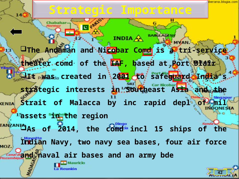
Strategic Importance
The Andaman and Nicobar Comd is a tri-service theater
comd. of the IAF, based at Port BlairIt was created in 2001 to safeguard India's strategic
interests in Southeast Asia and the Strait of Malacca by inc
rapid depl of mil assets in the region As of 2014, the comd incl 15 ships of the Indian Navy,
two navy sea bases, four air force and naval air bases and
an army bde
42

43
Chandigarh is a city and a union territory in northern part of
India that serves as the capital of the states of Haryana and
Punjab. As a union territory, the city is ruled dir by the
Union Govt of India and is not part of either state
The city tops the list of Indian States and Union Territories
by per capita income in the cty. The city was reported to be
the cleanest in India in 2010, based on a national Govt
study
As of 2011 India census, Chandigarh had a population of
960,787
Chandigarh is home to numerous inter state sporting teams
like Kings XI Punjab in The Indian Premier League (IPL)
Chandigarh

44
Gujarat
It is a Union Territory in western India. Nagar Haveli is
wedged b/w Maharashtra and Gujarat
The shared capital is Silvassa
Dadra and Nagar Haveli (DNH) are in the middle of the quite
undulating watershed of the Daman Ganga River, which
after the reservoir flows through Nagar Haveli and later
forms the short southern border of Dadra. The towns of
Dadra and Silvassa lie on the north bank of the river
While the territory is landlocked, the Arabian Sea lies just
to the west in Gujarat

45
Gujarat
About 43% of the land is under forest cover
The area of Dadra and Nagar Haveli is spread over 491 km2
It ranks 4th among the Union Territories and 32nd including
the states
On 31 Dec 1974 a treaty was signed b/w India and Portugal
on recognition of India's sovereignty over Goa, Daman, Diu,
Dadra and Nagar Haveli
Its nominal GDP inc to $360 million in the yr 2013 with a per
capita GDP of $1,050

46
Gujarat
For over 450 years, the coastal exclaves of Daman and Diu
on the Arabian Sea coast were part of Portuguese India,
along with Goa and Dadra and Nagar Haveli
Goa, Daman, and Diu were incorporated into the Republic
of India on 19 Dec 1961 by mil conquest. Portugal did not
recognise the Indian annex of these territories until 1974
According to the Constitution of India, Adm of Daman and
Diu is carried out by an Adm appt by President of India. An
Adm is an agent of the President not the head of state like a
Governor
47
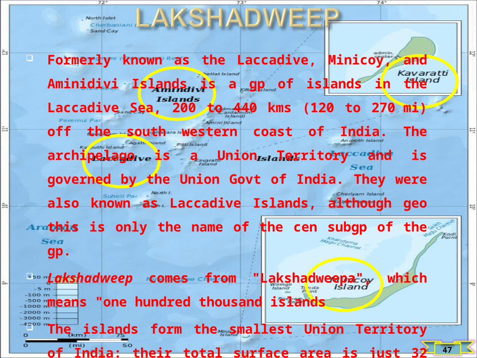
Formerly known as the Laccadive, Minicoy, and Aminidivi
Islands is a gp of islands in the Laccadive Sea, 200 to 440
kms (120 to 270 mi) off the south western coast of India.
The archipelago is a Union Territory and is governed by the
Union Govt of India. They were also known as Laccadive
Islands, although geo this is only the name of the cen
subgp of the gp.
Lakshadweep comes from "Lakshadweepa", which means
"one hundred thousand islands
The islands form the smallest Union Territory of India: their
total surface area is just 32 sq kms (12 sq mi)
48
Ten of the islands are inhabited. At the 2011 Indian census
the population of the Union Territory was 64,429. The maj of
the indigenous population is Muslim and most of them
belong to the Shafi School of the Sunni Sect
In 1956, during the reorg of Indian states, the Lakshadweep
islands were org into a separate union territory for adm
purposes
To safeguard India's vital shipping lanes to the Middle East,
and the growing relevance of the islands in security
considerations, an Indian Navy base, INS Dweeprakshak,
was commissioned on Kavaratti island

49
Lakshadweep forms a single Indian district and is governed
by an adm appt by the President of India
The union territory comes under the jurisdiction of the
Kerala High Court. The territory elects one member to the
Lok Sabha (lower house of the Parliament of India)
The inhabitants are known to practice different religious
customs that were once propounded by the Saint
Ubaidullah who is believed to be the propagator of Islam
religion in Lakshadweep
There are several festivals that have originated in the island
of Lakshadweep to mark the eminence of Islam. Eid-Ul-Fitr,
Muharram, Bakra Eid and Milad-Un-Nabi are the prominent
occasions
50
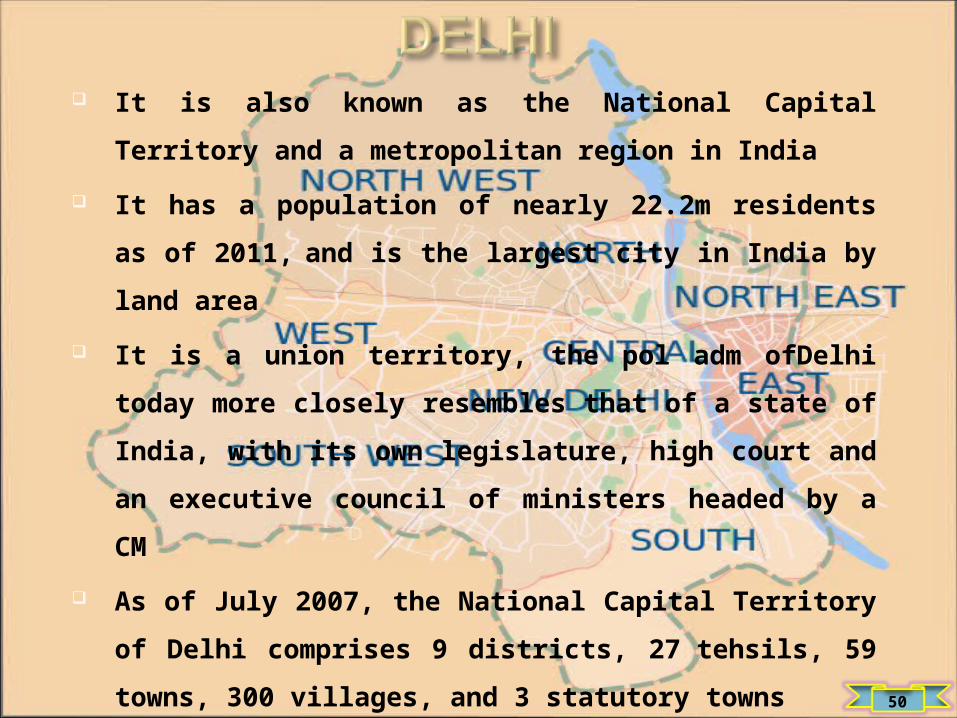
It is also known as the National Capital Territory and a
metropolitan region in India
It has a population of nearly 22.2m residents as of 2011, and
is the largest city in India by land area
It is a union territory, the pol adm ofDelhi today more
closely resembles that of a state of India, with its own
legislature, high court and an executive council of ministers
headed by a CM
As of July 2007, the National Capital Territory of Delhi
comprises 9 districts, 27 tehsils, 59 towns, 300 villages, and
3 statutory towns

51
Members of the legislative assembly are dir elected from
territorial constituencies
Delhi is the largest commercial cen in northern India , it has
an estimated net State Domestic Product (FY 2010) of
US$27 billion
According to the 2011 census of India, the population of
Delhi is 16,753,235
According to 1999–2000 estimate, the total no of people
living below the poverty line, defined as living on US$11 or
8.23% of the total population, compared to 27.5% of India as
a whole

52
The city Puducherry based on the French grid pattern and
features perpendicular streets
The town is divided into two sections:
The French Quarter ('White town')
The Indian quarter ('Black Town’)
Puducherry has almost a 100% literacy lvl
The union territory of Puducherry consists of 4 small
unconnected dist: Pondicherry, Karaikal and Yanam on the
Bay of Bengal and Mahé on the Arabian Sea
The territory has an area of 492 sq km
Its 2011 population was 1,244,464


ELECTION SYSTEM
54

Legislative Houses of State
55
Chattisgarh Orissa
West bengal
Bihar
LucknowDelhi
RajasthanMadhya Pradesh
Maharashtra

LEGISLATIVE ASSEMBLY
56
Delhi Lucknow Bihar
Rajasthan Madhya Pradesh
West bengal
Chattisgarh
OrissaMaharashtra

ELECTED MEMBERS
57
Delhi Lucknow Bihar
Rajasthan Madhya Pradesh
West bengal
Chattisgarh OrissaMaharashtra

RAJYA SABHA
58
59

60

61

LOK SABHA
62

PARLIAMENT
63

64

65

RESPONSIBILITIES
66