INDIAN MARINE FISHERY ADVISORY SYSTEM
38
A unique service to the fishermen community for locating PFZ in the seas INDIAN MARINE FISHERY ADVISORY SYSTEM Nimit Kumar Scientist (Advisory Services and Satellite Oceanography Group) Indian National Centre for Ocean Information Services (INCOIS) Ministry of Earth Sciences, Govt. of India Workshop for OSF Trainers & Operators November 27, 2014
Transcript of INDIAN MARINE FISHERY ADVISORY SYSTEM

A unique service to the fishermen community for locating PFZ in the seas
INDIAN MARINE FISHERY ADVISORY SYSTEM
Nimit Kumar Scientist (Advisory Services and Satellite Oceanography Group)
Indian National Centre for Ocean Information Services (INCOIS) Ministry of Earth Sciences, Govt. of India
Workshop for
OSF Trainers & Operators November 27, 2014

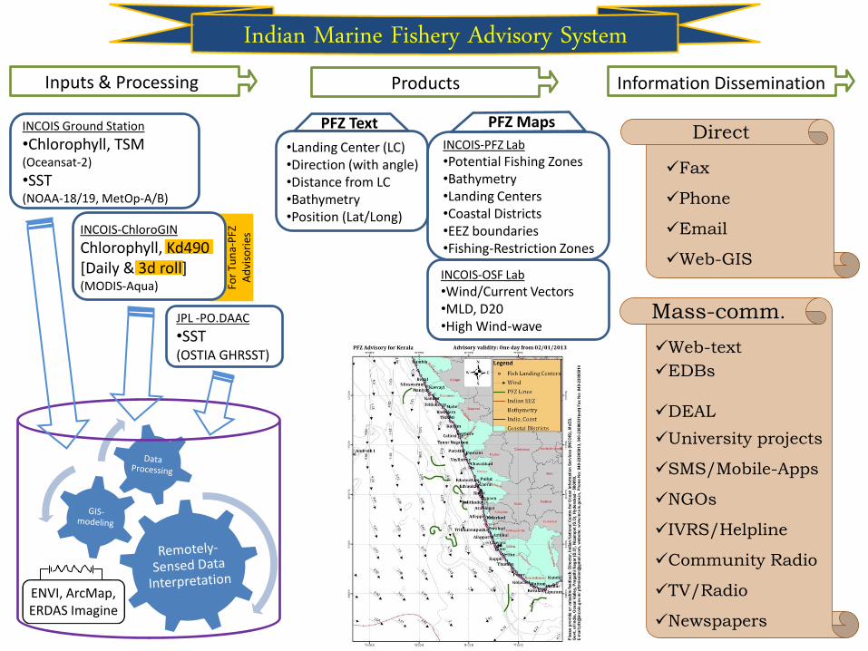
INCOIS Ground Station
•Chlorophyll, TSM (Oceansat-2)
•SST (NOAA-18/19, MetOp-A/B)
JPL -PO.DAAC
•SST (OSTIA GHRSST)
INCOIS-OSF Lab
•Wind/Current Vectors •MLD, D20 •High Wind-wave
INCOIS-PFZ Lab
•Potential Fishing Zones •Bathymetry •Landing Centers •Coastal Districts •EEZ boundaries •Fishing-Restriction Zones
PFZ Maps
Indian Marine Fishery Advisory System
•Landing Center (LC) •Direction (with angle) •Distance from LC •Bathymetry •Position (Lat/Long)
PFZ Text
Inputs & Processing Products Information Dissemination
Fo
r Tu
na-
PFZ
A
dvi
sori
es INCOIS-ChloroGIN
Chlorophyll, Kd490 [Daily & 3d roll] (MODIS-Aqua)
Direct
Fax
Phone
Web-GIS
Mass-comm.
Web-text
EDBs
DEAL
University projects
SMS/Mobile-Apps
NGOs
IVRS/Helpline
Community Radio
TV/Radio
Newspapers
ENVI, ArcMap, ERDAS Imagine

Part – 1 : Science & Process
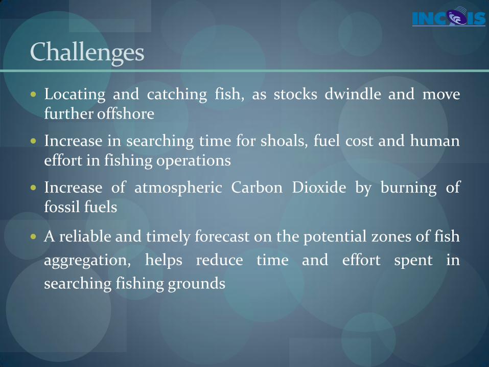
Challenges
Locating and catching fish, as stocks dwindle and move further offshore
Increase in searching time for shoals, fuel cost and human effort in fishing operations
Increase of atmospheric Carbon Dioxide by burning of fossil fuels
A reliable and timely forecast on the potential zones of fish
aggregation, helps reduce time and effort spent in
searching fishing grounds

Fishing Heritage - Fishermen
Kaladu (a kind of smell)
Muddy and oily water and calm Sea
Bird Congregation
Reflection in the Night
Bubbles breaking on Surface
Colour
Fish Availability
Type Quantity

Remote Sensing
Use of balloons and aircraft to detect the fish schools by eye
Detection of pelagic fish schools by highly skilled spotter pilots from aircraft
Their experience and intuition are not immediately transferable
Depth limit of detection that depends on illumination, sea state, and the skill of the individual spotter
Sp
utn
ik
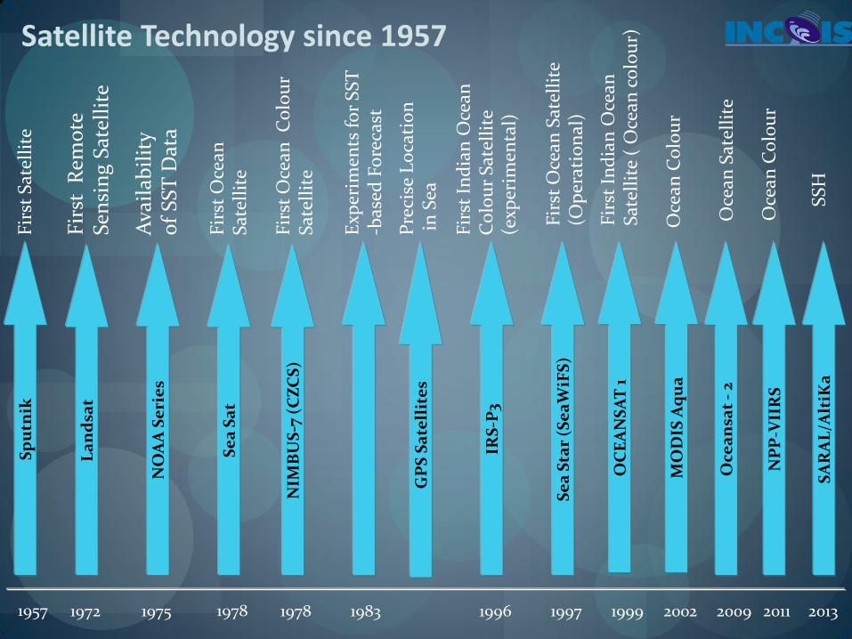
1957 1999 O
CE
AN
SA
T 1
1996
IRS
-P3
Oce
an
sat
- 2
2009
Fir
st S
atel
lite
1972
La
nd
sat
NO
AA
Se
rie
s
1975
Ava
ilab
ilit
y
of
SST
Dat
a
1978
Se
a S
at
NIM
BU
S-7
(C
ZC
S)
Fir
st O
cean
S
atel
lite
Se
a S
tar
(Se
aW
iFS
)
1997
Fir
st O
cean
Sat
elli
te
(Op
erat
ion
al)
Fir
st I
nd
ian
Oce
an
Sat
elli
te (
Oce
an c
olo
ur)
Satellite Technology since 1957 F
irst
Rem
ote
S
ensi
ng
Sat
elli
te
Fir
st O
cean
C
olo
ur
Sat
elli
te
Fir
st I
nd
ian
Oce
an
Co
lou
r S
atel
lite
(e
xper
imen
tal)
GP
S S
ate
llit
es
Pre
cise
Lo
cati
on
i
n S
ea
Oce
an S
atel
lite
1983 1978
Exp
erim
ents
fo
r S
ST
-b
ased
Fo
reca
st
2002
MO
DIS
Aq
ua
O
cean
Co
lou
r
NP
P-V
IIR
S
SA
RA
L/A
ltiK
a
2011 2013
Oce
an C
olo
ur
SS
H

Primary producers
Phytoplankton is an index of Primary productivity
Phytoplankton
Secondary consumers
Primary consumers
Food Chain
Higher trophic level e.g. Fishes

Remote Sensing
Fish Aggregation PFZ
OCM / MODIS NOAA AVHRR /
METOP
Upwelling Boundary
Food
SST
Phytoplankton Nutrients
Ocean Color
Processes
Fish Finding -The Remote Sensing Approach
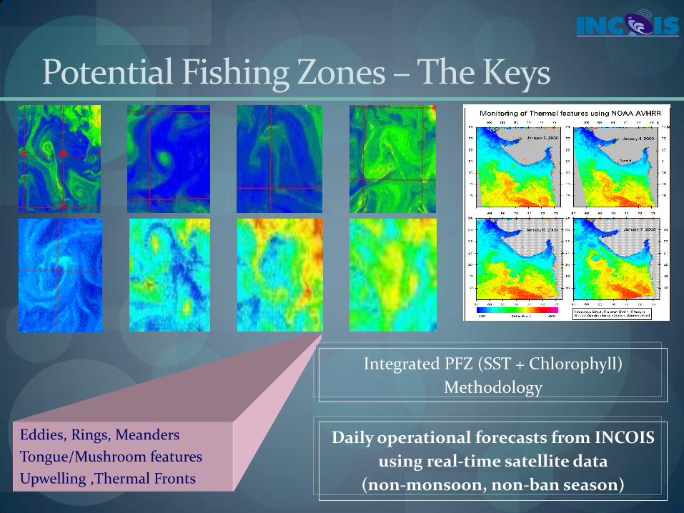
Eddies, Rings, Meanders
Tongue/Mushroom features
Upwelling ,Thermal Fronts
Integrated PFZ (SST + Chlorophyll)
Methodology
Potential Fishing Zones – The Keys
Daily operational forecasts from INCOIS
using real-time satellite data
(non-monsoon, non-ban season)
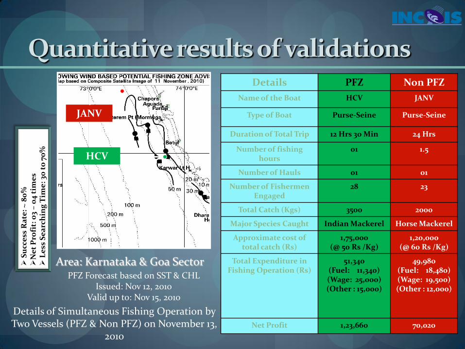
Details PFZ Non PFZ
Name of the Boat HCV JANV
Type of Boat Purse-Seine Purse-Seine
Duration of Total Trip 12 Hrs 30 Min 24 Hrs
Number of fishing hours
01 1.5
Number of Hauls 01 01
Number of Fishermen Engaged
28 23
Total Catch (Kgs) 3500 2000
Major Species Caught Indian Mackerel Horse Mackerel
Approximate cost of total catch (Rs)
1,75,000 (@ 50 Rs /Kg)
1,20,000 (@ 60 Rs /Kg)
Total Expenditure in Fishing Operation (Rs)
51,340 (Fuel: 11,340) (Wage: 25,000) (Other : 15,000)
49,980 (Fuel: 18,480) (Wage: 19,500) (Other : 12,000)
Net Profit 1,23,660 70,020
Quantitative results of validations
Details of Simultaneous Fishing Operation by Two Vessels (PFZ & Non PFZ) on November 13,
2010
PFZ Forecast based on SST & CHL Issued: Nov 12, 2010
Valid up to: Nov 15, 2010
Area: Karnataka & Goa Sector
JANV
HCV
S
ucc
ess
Ra
te:
~ 8
0%
Ne
t P
rofi
t: 0
3 –
04
tim
es
L
ess
Se
arc
hin
g T
ime
: 30
to
70
%
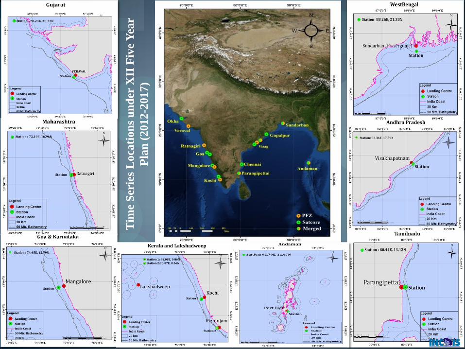
Tim
e S
erie
s L
oca
tion
s u
nd
er X
II F
ive
Yea
r
Pla
n (
2012
-2017)

•Tuna Potential of the Indian EEZ: 2, 78, 000 MT
•Annual Catch: 40, 000 MT •Forecast started with RS and in-situ data on experimental Basis
•Developed methodology based on Hind-cast Experiments •503 catch details from 12 vessels
•Dissemination in similar lines to PFZ
•Operationalised from November 2010 onwards
•Dedicated web pages for dissemination of the advisories (Feb 2011)
Tuna Fishery Advisories (Map & Text)
Species Specific advisories for Tuna

Sea Surface Height
Date of PFZ advisory: 26th July Boat owner: Mr. Rajkumar, Nagoor Pattinacherry, Nagapattinam District Fishing boat: Gill Netter Fishing Date: 29th July Catch: 7.5t Tuna Boats in ground: 100
Fish-1
Fish-2
SST
Proof of Concept

SATELLITE TELEMETRY STUDIES ON MIGRATION PATTERNS OF TUNAS IN INDIAN SEAS (SATTUNA)
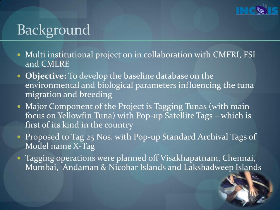
Background
Multi institutional project on in collaboration with CMFRI, FSI and CMLRE
Objective: To develop the baseline database on the environmental and biological parameters influencing the tuna migration and breeding
Major Component of the Project is Tagging Tunas (with main focus on Yellowfin Tuna) with Pop-up Satellite Tags – which is first of its kind in the country
Proposed to Tag 25 Nos. with Pop-up Standard Archival Tags of Model name X-Tag
Tagging operations were planned off Visakhapatnam, Chennai, Mumbai, Andaman & Nicobar Islands and Lakshadweep Islands

Popular Tags Available
Mainly four types of tags :
1. Conventional plastic tags ( Tag recovery: Fishery dependent)
2. Archival tags (Tag recovery: Fishery dependent)
3. Acoustic Tags
4. Satellite Tags
• Smart Positioning or Temperature Transmitting (SPOT)
• Pop-up satellite archival tags (Tag recovery: Fishery independent)
Plastic Fish Tags Archival Fish Tags Pop-up Satellite Archival Fish Tags

HOW IT WORKS
Sources: www.microwavetelemetry.com http://swfsc.noaa.gov/textblock.aspx?Division=PRD&ParentMenuId=212&id=12682 http://home.earthlink.net/~horizon18/npoess.htm

Description :
1. Antennae
2. Float with pressure sensor
3. Tag body
4. Light sensor
5. Nosecone with corrosional link,
6. RD1500 guillotine
7. Stainless steel thimbles
8. Stainless steel wire encased in tubing
9. Conventional plastic tag.
DIFFERENT PARTS OF A PSAT

RETENTION PERIOD OF DIFFERENT TAG HEADS
By Musyl et.all. 2007
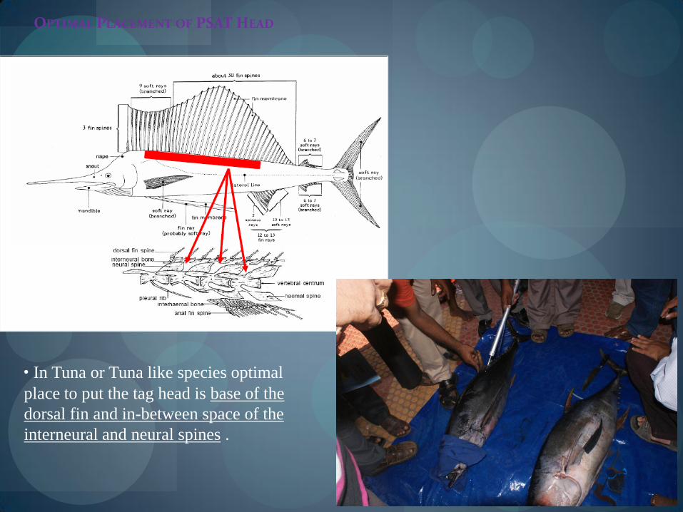
OPTIMAL PLACEMENT OF PSAT HEAD
• In Tuna or Tuna like species optimal
place to put the tag head is base of the
dorsal fin and in-between space of the
interneural and neural spines .

Calculating Geolocations

Calculating Geolocations

Geolocations

More at http://www.smru.st-andrews.ac.uk/MamVisAD/HowTos/
An Example of Advanced Techniques
The Journey has just begun…

DESERT STAR SYSTEMS
Ref. : Popular Science - May 2013
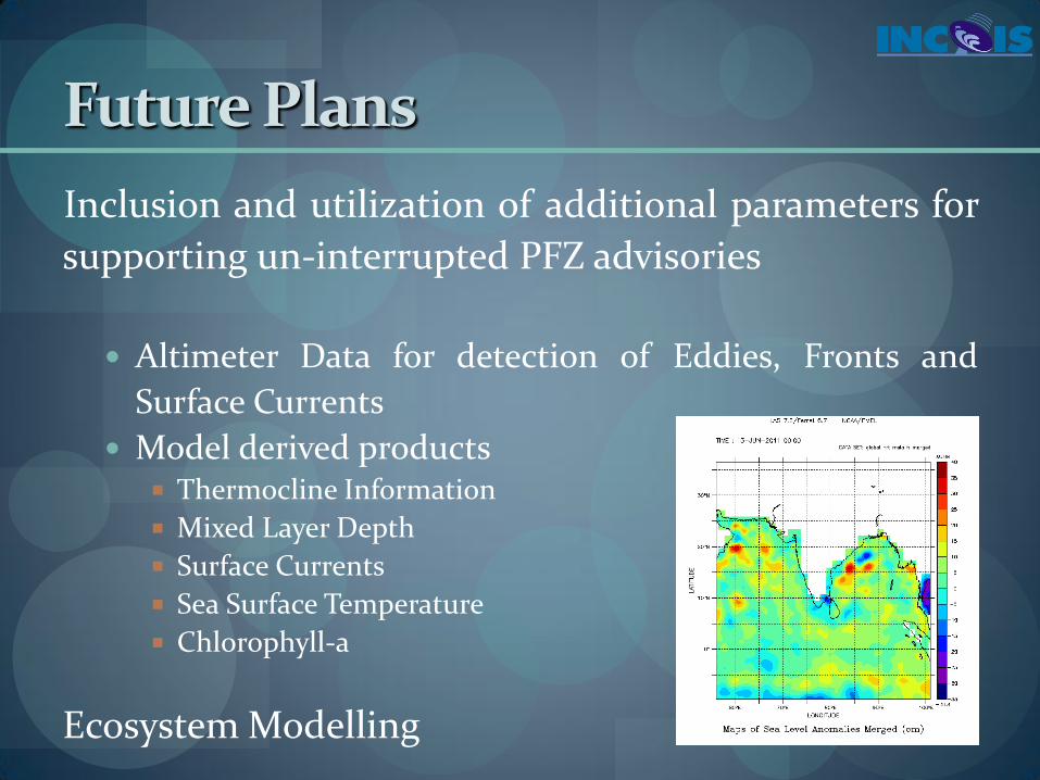
Future Plans
Inclusion and utilization of additional parameters for
supporting un-interrupted PFZ advisories
Altimeter Data for detection of Eddies, Fronts and
Surface Currents
Model derived products Thermocline Information
Mixed Layer Depth
Surface Currents
Sea Surface Temperature
Chlorophyll-a
Ecosystem Modelling

Part – 2 : Dissemination Scopes
INCOIS Ground Station
•Chlorophyll, TSM (Oceansat-2)
•SST (NOAA-18/19, MetOp-A/B)
JPL -PO.DAAC
•SST (OSTIA GHRSST)
INCOIS-OSF Lab
•Wind/Current Vectors •MLD, D20 •High Wind-wave
INCOIS-PFZ Lab
•Potential Fishing Zones •Bathymetry •Landing Centers •Coastal Districts •EEZ boundaries •Fishing-Restriction Zones
PFZ Maps
Indian Marine Fishery Advisory System
•Landing Center (LC) •Direction (with angle) •Distance from LC •Bathymetry •Position (Lat/Long)
PFZ Text
Inputs & Processing Products Information Dissemination
Fo
r Tu
na-
PFZ
A
dvi
sori
es INCOIS-ChloroGIN
Chlorophyll, Kd490 [Daily & 3d roll] (MODIS-Aqua)
Direct
Fax
Phone
Web-GIS
Mass-comm.
Web-text
EDBs
DEAL
University projects
SMS/Mobile-Apps
NGOs
IVRS/Helpline
Community Radio
TV/Radio
Newspapers
ENVI, ArcMap, ERDAS Imagine

Marine Fishery-The Indian Scenario
Several Species - Pelagic and Demersal Classes
Potential: About 3.921 MT per annum (D-2.02; P-1.67; O-0.24)
Harnessing: About 3.32 MT per annum
About 7 Million Fishing population spanning 3,202 Marine Fishing Villages
1.25 Million Active Marine Fishermen
2,38,772 Non-mechanised / Motorised / Mechanised/ DSVs
70 % Catch from West Coast
Gross Earnings at last sales: Rs. 36, 964 Cr
Marine Products Export Value: Rs. 12, 000 Cr (8 lakh tonnes)
Source: CMFRI

Total users statistics of PFZ advisory
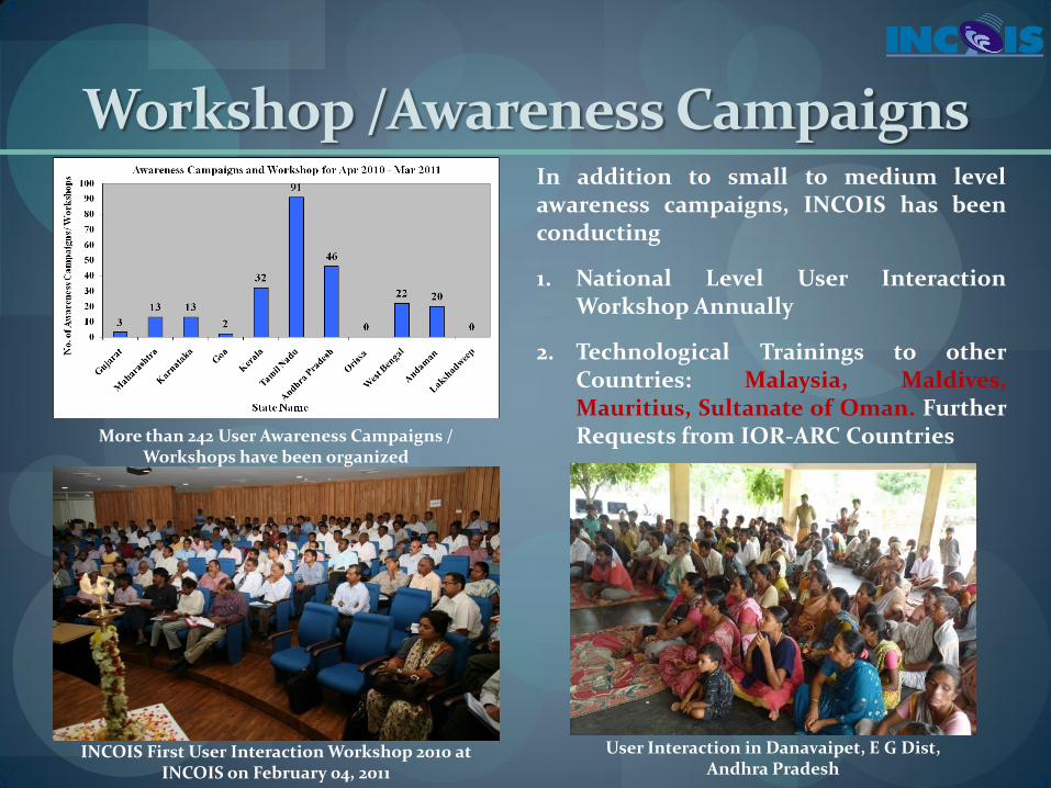
Workshop /Awareness Campaigns
More than 242 User Awareness Campaigns / Workshops have been organized
INCOIS First User Interaction Workshop 2010 at INCOIS on February 04, 2011
In addition to small to medium level awareness campaigns, INCOIS has been conducting
1. National Level User Interaction Workshop Annually
2. Technological Trainings to other Countries: Malaysia, Maldives, Mauritius, Sultanate of Oman. Further Requests from IOR-ARC Countries
User Interaction in Danavaipet, E G Dist, Andhra Pradesh

Website with Web GIS Facility
Phones & Faxes
Location Based
New Generation E.D. Boards
News Papers
E.D. Boards
Doordarshan
Fishermen Community
2007 1999 2002 2001 2003 2004 2005 2006
E - mails
2008 and FURTHER
SMS, IVRS, Help lines, Voice Messages, Information Kiosks, etc.
Dissemination of PFZ Advisories
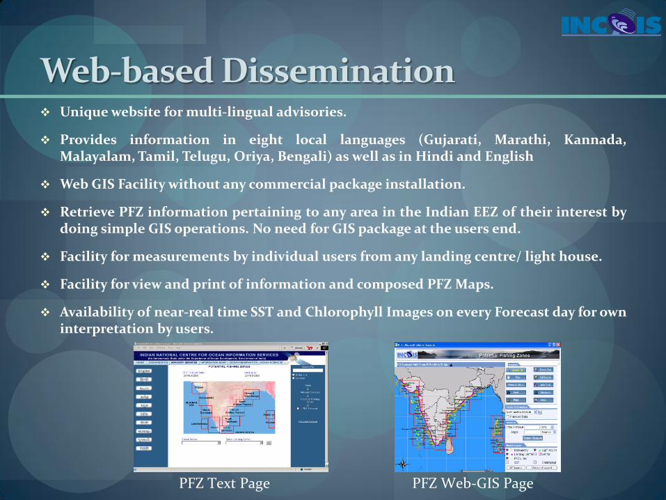
Web-based Dissemination Unique website for multi-lingual advisories.
Provides information in eight local languages (Gujarati, Marathi, Kannada, Malayalam, Tamil, Telugu, Oriya, Bengali) as well as in Hindi and English
Web GIS Facility without any commercial package installation.
Retrieve PFZ information pertaining to any area in the Indian EEZ of their interest by doing simple GIS operations. No need for GIS package at the users end.
Facility for measurements by individual users from any landing centre/ light house.
Facility for view and print of information and composed PFZ Maps.
Availability of near-real time SST and Chlorophyll Images on every Forecast day for own interpretation by users.
PFZ Text Page PFZ Web-GIS Page
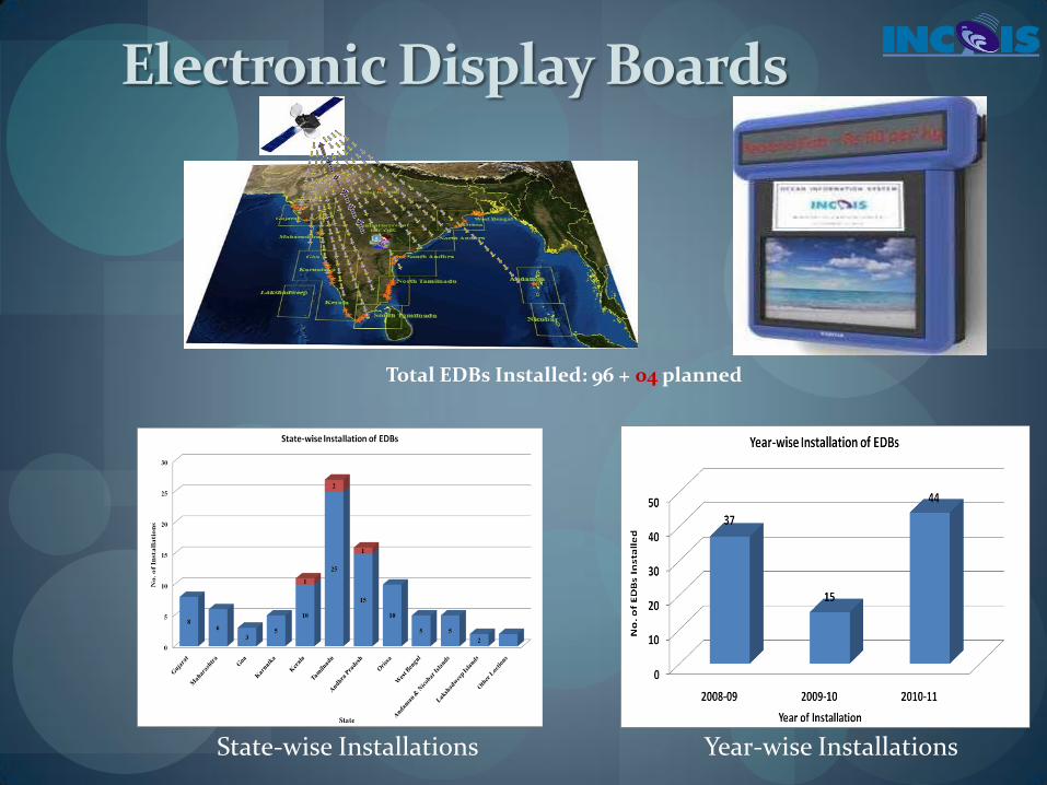
Electronic Display Boards
State-wise Installations Year-wise Installations
Total EDBs Installed: 96 + 04 planned

Mobile Applications
Liaising with the following service providers for disseminating the PFZ, OSF and Tsunami warnings through their Mobile Networks
Handygo (F-Technologies Pvt. Ltd.) - PAN India level – Behtar Zindagi - Interactive Voice Response (IVR) in regional language – MoU signed (Call to Behtar Zindagi (Better Life) short code“55678 and 556780,” which is
available for Airtel & Tata subscribers PAN India, and is available on Idea & Uninor in limited regions)
Spice Digital Limited – SMS, IVRS – regional language – MoU Signed – Designing is in progress
Fishermen Help lines in Andhra Pradesh and Tamilnadu in collaboration with MS Swaminathan Research Foundation, Chennai
Help line numbers :
Andhra Pradesh – 7569059856, 7569079047;
Tamilnadu – 9282442311, 9282442312
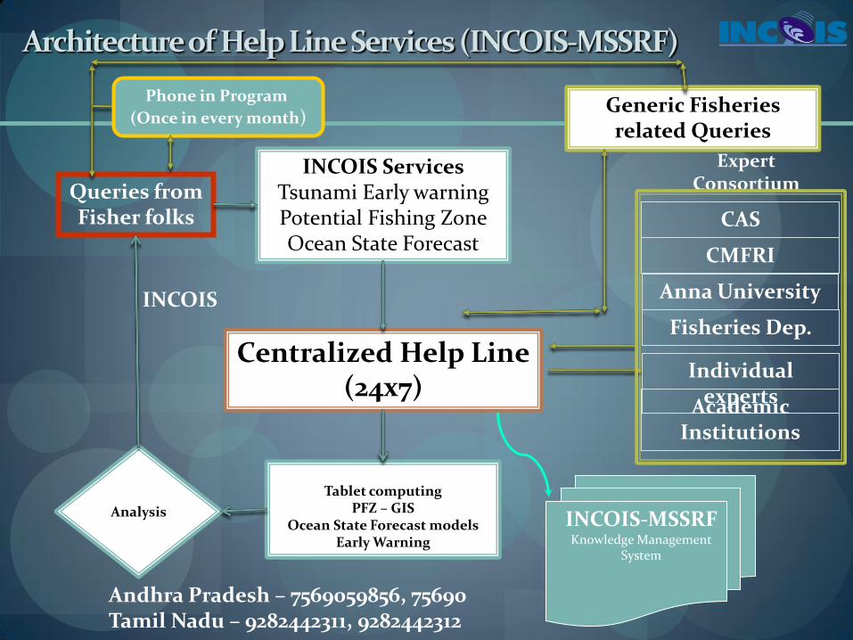
Expert Consortium
Centralized Help Line (24x7)
INCOIS Services Tsunami Early warning Potential Fishing Zone Ocean State Forecast
Queries from Fisher folks
Tablet computing PFZ – GIS
Ocean State Forecast models Early Warning
Analysis
INCOIS
Generic Fisheries related Queries
Anna University
Fisheries Dep.
Individual experts
CAS
CMFRI
Academic Institutions
INCOIS-MSSRF Knowledge Management
System
Phone in Program
(Once in every month)
Architecture of Help Line Services (INCOIS-MSSRF)
Andhra Pradesh – 7569059856, 75690 Tamil Nadu – 9282442311, 9282442312

THANK YOU