Indian Journal of Marine Sciences 19- 2£ -...
8
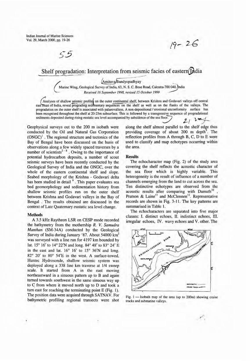
Indian Journal of Marine Sciences Vol. 29, March 2000, pp. 19-26 19- 2£ .. Shelf Interpretation seismic facies of eastern@dia . / . _ Wing, Geological Survey of India, 63, N. S. C. Bose Road, Received 16 September 1998. revised 15 October 1999 t:nalyses of shallow on the outer.continental shelf. between Krishna and Godavari valleys off central or India, reveal prograding sedAnentary sequences on the shelf as well as on the flanks of the valleys. The progradation on the outer shelf is associated with palaeovalleys. A non-depositional! erosional unconformity surface has been recognised throughout the shelf at 20-2Sm subsurface. This is followed by a transgressive sequence of progradational sediments deposited during rising eustatic sea level accompanied by subsidence of the sea floo;::-; \ , 'rt!!!...-i. 2-/ v :.7-- Geophysical surveys out to the 200 m isobath were along the shelf almost parallel to the shelf edge thus conducted by the Oil and Natural Gas Corporation providing coverage of about 200 m depth 9 , The (ONGq' . The regional structure and tectonics of the reflection profiles from A through B, C, D to E were Bay of Bengal have been discussed on the basis of used to classify and map echotypes occurring within observations along a few widely spaced traverses by a the area. number of scientists 2 . 8 . Owing to the importance of potential hydrocarbon deposits, a number of scout seismic surveys have been recently conducted by the Geological Survey of India and the ONGC, over the whole of the eastern continental shelf and slope. Seabed morphology of the Krishna - Godavari delta has been studied in detail 9 • This paper evaluates sea bed geomorphology and sedimentation history from shallow seismic profiles run on the outer shelf between Krishna and Godavari valleys in the Bay of Bengal . The results obtained are discussed in the context of Late Quaternary eustatic sea level change. Methods A 3.5 kHz Raytheon LSR on CESP mode recorded the bathymetry from the mothership R. V. Samudra Manthan (SM-34A) conducted by the Geological Survey of India during January '87. About 54000 km 2 was surveyed with a line run for 4197 km bounded by lat. 15° 16' to 14° 22'N and long. 84° 48' to 83° 24' E in the east and lat. 16° 16' to 15° 36'N and long. 82° 20' to 80° 54'E in the west. A surface-towed, Huntec Hydrosonde, shallow seismic system was deployed along a 338 line km traverse at 114 sweep scale. It started from A in the east moving northeastward in a sinuous pattern up to B and again turned towards southwest in the same sinuous way up to C from where it moved north up to D and took a tum east for reaching the terminating point E (Fig. 1). The position data were acquired through SATNAV. For bathymetric profiling regional transects were shot Results The echocharacter map (Fig. 2) of the study area covering the shelf reflects the acoustic character of the sea floor which is highly variable. This heterogeneity is the result of influence of a number of channels emerging from the land to cut across the sea. Ten distinctive echotypes are observed from the acoustic results after comparing with Damuth \0 , Prats on & Laine ll and McClennen '2 . Representative records are shown in Fig. 3-11. The key patterns are summarised in Table 1. The echocharacters are separated into five major classes: I. distinct echoes, II. indistinct echoes, III. irregular echoes, IV. wavy echoes and V. other. The Fig. I - Isobath map of the area (up to 200m) showing cruise tracks and submarine valleys.
-
Upload
nguyencong -
Category
Documents
-
view
216 -
download
2
Transcript of Indian Journal of Marine Sciences 19- 2£ -...
Indian Journal of Marine Sciences Vol. 29, March 2000, pp. 19-26
19- 2£
.. Shelf progra~ati~I?:: Interpretation fro~ seismic facies of eastern@dia . ~......,.."
/ 0rnitav~andyop:ci~yay . _
~arine Wing, Geological Survey of India, 63, N. S. C. Bose Road, calcutta-7~ndia Received 16 September 1998. revised 15 October 1999
t:nalyses of shallow ~~iE,£!:2!ile' on the outer. continental shelf. between Krishna and Godavari valleys off central eas~~st or India, reveal prograding sedAnentary sequences on the shelf as well as on the flanks of the valleys. The progradation on the outer shelf is associated with palaeovalleys. A non-depositional! erosional unconformity surface has been recognised throughout the shelf at 20-2Sm subsurface. This is followed by a transgressive sequence of progradational sediments deposited during rising eustatic sea level accompanied by subsidence of the sea floo;::-; \ ,'rt!!!...-i.
~ 2-/ v :.7--Geophysical surveys out to the 200 m isobath were along the shelf almost parallel to the shelf edge thus conducted by the Oil and Natural Gas Corporation providing coverage of about 200 m depth9
, The (ONGq' . The regional structure and tectonics of the reflection profiles from A through B, C, D to E were Bay of Bengal have been discussed on the basis of used to classify and map echotypes occurring within observations along a few widely spaced traverses by a the area. number of scientists2
. 8 . Owing to the importance of potential hydrocarbon deposits, a number of scout seismic surveys have been recently conducted by the Geological Survey of India and the ONGC, over the whole of the eastern continental shelf and slope. Seabed morphology of the Krishna - Godavari delta has been studied in detail 9 • This paper evaluates sea bed geomorphology and sedimentation history from shallow seismic profiles run on the outer shelf between Krishna and Godavari valleys in the Bay of Bengal . The results obtained are discussed in the context of Late Quaternary eustatic sea level change.
Methods A 3.5 kHz Raytheon LSR on CESP mode recorded
the bathymetry from the mothership R. V. Samudra Manthan (SM-34A) conducted by the Geological Survey of India during January '87. About 54000 km2
was surveyed with a line run for 4197 km bounded by lat. 15° 16' to 14° 22'N and long. 84° 48' to 83° 24' E in the east and lat. 16° 16' to 15° 36'N and long. 82° 20' to 80° 54'E in the west. A surface-towed, Huntec Hydrosonde, shallow seismic system was deployed along a 338 line km traverse at 114 sweep scale. It started from A in the east moving northeastward in a sinuous pattern up to B and again turned towards southwest in the same sinuous way up to C from where it moved north up to D and took a tum east for reaching the terminating point E (Fig. 1). The position data were acquired through SATNAV. For bathymetric profiling regional transects were shot
Results The echocharacter map (Fig. 2) of the study area
covering the shelf reflects the acoustic character of the sea floor which is highly variable. This heterogeneity is the result of influence of a number of channels emerging from the land to cut across the sea. Ten distinctive echotypes are observed from the acoustic results after comparing with Damuth \0 ,
Prats on & Lainell and McClennen '2 . Representative records are shown in Fig. 3-11. The key patterns are summarised in Table 1.
The echocharacters are separated into five major classes: I. distinct echoes, II. indistinct echoes, III. irregular echoes, IV. wavy echoes and V. other. The
Fig. I - Isobath map of the area (up to 200m) showing cruise tracks and submarine valleys.
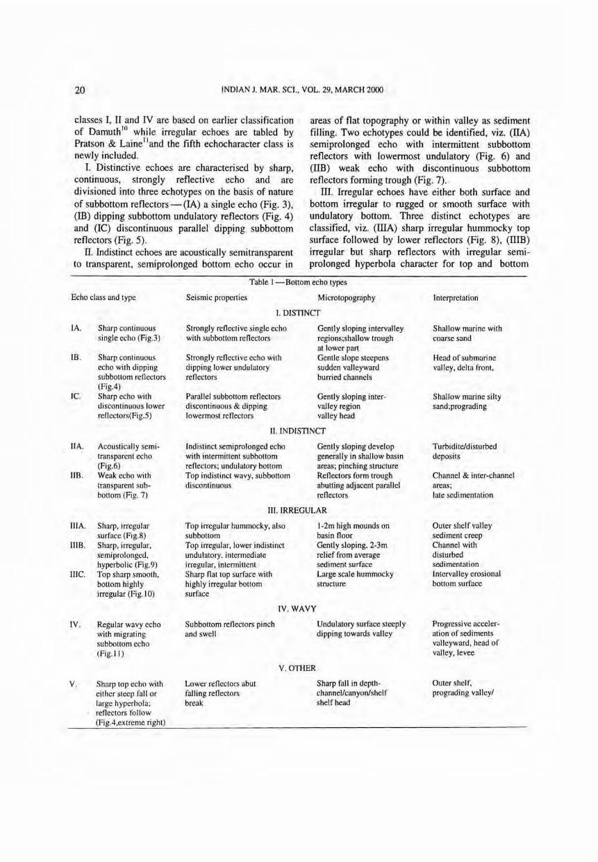
20 INDIAN 1. MAR. SCI., VOL. 29, MARCH 2000
classes I, II and IV are based on earlier classification of Damuth lO while irregular echoes are tabled by Prats on & Laine II and the fifth echocharacter class is newly included.
I. Distinctive echoes are characterised by sharp, continuous, strongly reflective echo and are divisioned into three echotypes on the basis of nature of subbottom reflectors - (IA) a single echo (Fig. 3), (m) dipping sub bottom undulatory reflectors (Fig. 4) and (lC) discontinuous parallel dipping subbottom reflectors (Fig. 5).
II. Indistinct echoes are acoustically semitransparent to transparent, semiprolonged bottom echo occur in
areas of flat topography or within valley as sediment filling. Two echotypes could be identified, viz. (IIA) semiprolonged echo with intermittent subbottom reflectors with lowermost undulatory (Fig. 6) and (lIB) weak echo with discontinuous subbottom reflectors forming trough (Fig. 7).
III. Irregular echoes have either both surface and bottom irregular to rugged or smooth surface with undulatory bottom. Three distinct echotypes are classified, viz. (IlIA) sharp irregular hummocky top surface followed by lower reflectors (Fig. 8), (I1IB) irregular but sharp reflectors with irregular semiprolonged hyperbola character for top and bottom
Table I - Bottom echo types
Echo class and type Seismic properties Microtopography Interpretation
I. DISTINCT
IA. Sharp continuous Strongly retlective single echo Gently sloping intervalley Shallow marine with single echo (Fig.3) with subbottom retlectors regions;shallow trough coarse sand
at lower part lB . Sharp continuous Strongly retlective echo with Gentle slope steepens Head of submarine
echo with dipping dipping lower undulatory sudden valleyward valley, delta front, sub bottom retlectors retlectors burried channels (Fig.4)
Ie. Sharp echo with Parallel sub bottom retlectors Gently sloping inter- Shallow marine silty discontinuous lower discontinuous & dipping valley region sand;prograding retlectors(Fig.5) lowermost retlectors valley head
II . INDISTINCT
IIA. Acoustically semi- Indistinct semiprolonged echo Gently sloping develop Turbidite/disturbed transparent echo with intermittent subbottom generally in shallow basin deposits (Fig.6) retlectors; undulatory bottom areas; pinching structure
liB. Weak echo with Top indistinct wavy, subbottom Retlectors form trough Channel & inter-channel transparent sub- discontinuous abutting adjacent parallel areas; bottom (Fig. 7) retlectors late sedimentation
III . IRREGULAR
iliA. Sharp, irregular Top irregular hummocky, also I-2m high mounds on Outer shelf valley surface (Fig.8) subbottom basin tloor sediment creep
IIIB. Sharp, irregular, Top irregular, lower indistinct Gently sloping, 2-3m Channel with semiprolonged, undulatory, intermediate relief from average disturbed hyperbolic (Fig.9) irregular, intermittent sediment surface sedimentation
1IIe. Top sharp smooth, Sharp tlat top surface with Large scale hummocky Intervalley erosional bottom highly highly irregular bottom structure bottom surface irregular (Fig. I 0) surface
IV. WAVY
IV. Regular wavy echo Subbottom retlectors pinch Undulatory surface steeply Progressive acceler-with migrating and swell dipping towards valley ation of sediments subbottom echo valleyward, head of (Fig. I I) valley, levee
V. OTHER
V. Sharp top echo with Lower retlectors abut Sharp fall in depth- Outer shelf, either steep fall or falling retlectors channel/canyon/shelf prograding valley/ large hyperbola; break shelf head retlectors follow (Fig.4,extreme right)

BANDYOPADHY A Y: SEISMIC FACIES OF EASTERN INDIA 21
0uDuBWmc mnE:! ~rv {8JtC I z I DlA I·: v:lv r:::Jro:oJ ~lIAlL!lIDB
Fig. 2. - Distribution of bottom and subbottom reflection characters in the survey area - key patterns are summarised in Table I.
reflectors (Fig. 9) and (IIIC) top surface sharp smooth and flat with highly irregular bottom surface (Fig. 10).
IV. Wavy echoes are described here as 'a regular wavy echo with migrating subbottom reflectors, ie., migrating sedimentary waves (Fig. 11).
V. Other is a special class which is distinctively morphologic featured in the outer shelf area either at the point of shelf break or at the prograded valley head as lower reflectors abut against falling surface (Fig. 4, extreme right) .
The overall pervasive fabric of the echotypes are normal to the continental margin. Traversing from west end a sharp continuous single echo (Type IA) is found to occupy a stretch of about 20 km indicating an area where the sediments being carried from continents are distributed onto the outershelf. The
o ."
Fig. 3-Sharp continuous strongly reflective single echo with subbottom reflectors (IA).
Fig. 4-Sharp continuous echo with dipping subbottom undulatory reflectors (18), top and bottom reflectors fall steeply at extreme right (V).

22 INDIAN 1. MAR. SCI., VOL. 29, MARCH 2000
Fig. 5-Distinct sharp echo with parallel discontinuous subbottom reflectors and dipping lower ones (lC)
o '11M
Fig. 6-Indistinct semiprolonged echo with lowermost highly undulatory reflectors (IIA).
o Um
Fig. 7 - Weak echo with discontinuous subbottom reflectors forming troughs, parallel reflectors on both sides abut trough (liB).

BANDYOPADHYA Y: SEISMIC FACIES OF EASTERN INDIA
o
Fig. 8-lrregular hummocky top surface with parallel subbottom reflectors (iliA).
~Ia'-:--- -- ___ ----=_-=~o , . ~Vd~-~::"_:':--=-=- ___ ---=..:; --10111
---- ~-""~-6-- -:-_ --- - _r ----------;.;"- . :::"'=-- = --- -- .~. & ----___ ___~:.~ ... ~--:::---__ -- :-_-=----=-=-=-_ ~~ -= _ _ :;:aC.
o . , km.
Fig. 9-lrregular sharp echo surface and intermittent subsurface; lowermost indistinct; incising channel cuts through valley floor (IIIB).
=- ...- - -----.- .... ~ ~ -----=-----:::::-
o , k~.
Fig. I O-Flat smooth top with highly irregular bottom reflectors (IIIC).
23

24 INDIAN 1. MAR. SCI., VOL. 29, MARCH 2000
Fig. 11- Regular wavy echo with migrating subbottom reflectors, pinch and swell structure (IV).
sediments are of coarse grained sand. This is followed by about 8 km wide zone having both top and subbottom irregular reflectors with a moderate hyperbole (Type IIIB) that might indicate an incising channel on the surface with a 2-3 m high levee on both the banks and a bifurcating valley floor on the surface. The fossil channel underneath is evident from lower reflectors. To its east again a sharp continuous single echo (Type IA) appears for about 10 km lateral extent. From the west end up to this point the area falls in between two submarine channels, seaward extension of two tributaries of the Krishna river. This is the area, in general, of sediment accumulation fed by the channels from both ends and the middle part is slightly disturbed by the influence of probable turbidity current flowing through a long-time standing channel which has small levee on banks. This channel may be an extension of another tributary shown in the land part of Fig. I.
Western bank of the seaward extension of easternmost Krishna valley is represented following east by a sharp continuous echo with dipping truncated subbottom reflectors (Type IB). This acoustically fine transparent layers of clinoform character delineates prograding foreset bedding of valley edge in a delta front ll . The undulatory bottom reflector depicts burried fluvial channels. The lowermost recognisable strata on the banks occur at about 20 m subsurface (assessing a velocity of 1.8 mlsec for a mixed shelf sediment of sand and clay). This is a prograding sequence and the lowermost reflector defines a combination of very thin of sediments of which each film monoclinally drapes at the bank edge covering a part of the previous draping film (Fig. 4). This bottommost reflector depicts a
horizon of nondeposition or erosion with persuasive evidence of truncated reflectors that are picked up in the records. The immidiate overlying sediments were transported past this horizon and accumulated on the slope. The overlying reflectors are also progradational as the sloping beds extend into horizontal layers. In the classification of seismic facies of pro-fluviatile deltas and outer shelves, "progressive oblique" for the former and "progressive sigmoid" for the latter are termed I3
-15
• The part of the Krishna valley in submarine is of 7 km wide in the transect. This reflects in the echocharacter map. The eastern bank also bears the same character as its western one and therefore represented by Type lB. However, in between the valley walls and floor the exhibited reflectors have sharp top echo with either sudden steep fall or large hyperbola (Type V) and the lower reflectors abut the draped ones indicating a rugged valley wall and floor.
The Krishna submarine valley is followed east by a wide zone of Narsapur Bay. The area is characterised by a combination of echo characters comprising distinct sharp, acoustically semitransparent indistinct and irregular surface and bottom reflectors. Record of about 12 km length could not be picked up due to mechanical fault of the instrument. Distinct sharp multilayered parallel reflectors with discontinuous and dipping lower ones (Type IC) are characteristic of gentle sloping intervalley region with a likely prograded valley head but having silty sand sediment of shallow marine environment. There are valleys/troughs in the area having top with parallel discordant and discontinuous trough shaped reflectors. Horizontal parallel discontinuous layers on

BANDYOPADHYA Y: SEISMIC FACIES OF EASTERN INDIA 25
both sides abut the trough reflectors. One such palaeo valley is shown in Fig. 7 (Type lIB) located between Gautami Godavari and Vashishtha Godavari submarine channels. This valley is about 3 km wide. Distinct Type IA indicates a smooth undisturbed area for is a considerable space. Irregular surface and bottom reflectors (Type lIIB) and even sometimes with highly irregular bottom reflectors (Type IIIC) are found to be present further east and more precisely west of submarine channel of extended Vashishtha river. This indicates a highly erosional subbottom floor which comes as near as within 10 m below the sea floor. Thus the Narsapur Bay located between the two river valleys, the Krishna and the Godavari, records an overall near flat top surface and irregular bottom surface. The large scale irregularlhummocky/troughl truncated pattern of the lower reflectors are indicative of uncoformable surface having erosional or nondepositional character.
There is a small area showing rugged hyperbolic echo character of type V, an evidence of a channel in the area which is followed eastward by a 12 km wide zone of indistinct semiprolonged echo with intermittent subbottom reflectors and irregular undulatory lowermost surface (Type IIA). This is resulted from a disturbed depositional environment possibly due to combined effect of turbidite deposit and spilling over of the sediments onto the bank from the channel. This channel is the extended submarine part of the Vashishtha Godavari river whose west bank shows typical wavy echo with migrating subbottom reflectors (Type IV). The layers are dipping towards the valley and the reflectors are of pinch and swell character. Thus the lowermost truncated layer which is reflected from less than 20m subsurface becomes an erosional or nondepositional
. surface. The valley floor also records migrating subbottom reflectors. The eastern bank is about 40 km wide with characteristic of sharp top irregular surface and irregular semiprolonged reflectors with a few hyperbole indicative of small submarine channels (Type IIIB). At a few places echo characters of Type IB are found for the lowermost reflectors. The facies of such seismic reflectors is described as "progressive oblique,,1 3. 15 . The immidiate reflectors are inclined, irregular, wavy, commonly exhibiting mounded and draped patterns. These are the variety of off-lap seismic reflections l5 where the reflections collectively compose a wedge to lensoid shaped unit that pinches out basinward. This type of off-lap is termed "oblique progradational seismic facies" . The features of the
eastern bank can be compared to "sigmoid progradational seismic facies". The top surface and subbottom reflectors of valley floor are highly irregular but parallel to each other.
The adjacent area exhibits indistinct semiprolonged echo with intermittent subbottom reflectors (Type IIA). This is again the effect of turbidite deposit on the western bank of seaward extended channel of Gautami Godavari river. At places, however, the lowermost surface records highly undulatory indicating an unconformable surface at about 25 m below the sea floor. .
A seismic section, normal to the shelf break, extends between the 100 m and 150 m isobaths. Type Ie echocharacter is observed with seaward progradational sediment wedge (Fig. 5) and found only on the shelf break. As the sloping beds extend into horizontal layers, the seismic facies becomes "progradational sigmoid".
Discussion The study of the shallow seismic records of the
area reveals that the banks of both the Krishna and Godavari river valleys are prograded towards their respective valley axes. The seismic profiles for the banks of the Krishna valley indicate. progressive oblique facies for the lowermost recognisable layer and progressive sigmoid facies for the younger sediments. The banks of the Godavari valley depict offlap seismic reflections, typifying oblique progradational seismic facies for the western flank and progressive sigmoid for the eastern one. All the channels and palaeo valleys picked up in the records have a common seaward trend of their valley floor axis9 and they are also prograded. The shelf is identified as sigmoid progradational seismic facies .
Thus it is concluded that the shelf which includes the Krishna - Godavari delta, is a prograded one. Such a profluviatile delta is the result of fluvial deposits trapped when they arrive at the open sea. These deposits are later scattered by strong longshore drift during the southwest monsoon and thus form the prograded flanks for the submerged valleys in the area. The seismic facies as interpreted in the area is progressive sigmoid or oblique, and is related to subsidence for this case l6
. The lowermost reflector is characteristic of the irregular, hummocky or wavy facies in most of the areas. Near the shelf break or valley mouth an oblique progradational facies is interpreted for the just overlying sediments indicating rapid deposition of sediments in sloping beds passing

26 INDIAN 1. MAR. SCI., VOL. 29, MARCH 2000
over the undulatory horizon. This undulatory horizon is considered to be an unconfonnity characteristic of either erosional or nondepositional environment. This distinctive surface feature has been observed in the whole studied area within 65 to 120 m water depth and at 20-25 m subsurface.
The basin is described as pericratonic divergent margin type and the shore as submerged protrubesent deltaic 17. The entire region is within the active tectonic belt and has experienced relative sealevel changes due to subsidence or uplift in addition to the glacial effect during the Quaternary period.
The unconformity is a signature of the peak of the last glacial period (i.e., the Wurm glaciation or the Wisconsin glaciation) when the sea level fell maximum 120 m world wide 1S
-21
. A brief period of exposure of this unconformable horizon is followed by a transgression period when the sea level began to rise (Flandrian transgression). Therefore the last 20 -25 m wedge of sediments got deposited during this trangression period in this area of subsidence.
However, further work will throw more light on the history of sedimentation and the behaviour of eustatic sea level change during the later phase of the Quaternary.
Acknowledgement
The author expresses his sincere thanks to anonymous scrutinizer for improving the manuscript.Thanks are due to all the participant scientists on board of Cruise SM-34A.
References I Shenai K R & Rao M S, Bull 0 N C C ,19 (1982) 87. 2 Subba Rao M, Mar. Ceo!., 12 (1964) 59. 3 Currey J R & Moore D G, Ceol Soc Am Bull, 82 (1971) 563. 4 Currey J R, Emmel F J, Moore D G & Raitt R W, in The
ocean basins and margins: The Indian Ocean, vol. 6 edited by E M Narain & F G Stehli , (Plenum Press, New York) 1983,399.
5 Naini B R & Layden R, J Ceol Res, 78 (1973) 8711 . 6 Moore D G, Currey J R, Raitt R W & Emmel F J , in Initial
Report of D S D P, vol. 22, edited by von der Borch, C Christopher & J G Sclater (U S Government Printing Office,Washington DC) 1974,403.
7 Rao T C S & Bhaskara Rao V, Tectonophysics, 124 (1986) 141.
8 Rao T C S ,Lakshminarayana S & Sharma K V L N, Indian J MarSci , 16 (1987) 15.
9 Bandyopadhyay A, Raha B N & Das S, Indian J Mar Sci, 23 (1994) 143 .
10 Damuth J E, Mar Ceol, 38 (1980) 51 . II Pratson L F & Laine D P, Mar Ceol, 89 (1989) 87. 12 McClennen C E, Mar Ceol, 89 (1989)69. 13 Sangree J B, in Framework, facies and oil trapping
characteristics of the upper continental margin, edited by A H Bouma, Am Assoc Petr Ceol Stud, 7 (1978) 87.
14 Mitchum R M, Vail P R & Sangree J R, Mem Am Assoc Petr Ceol, 26 (1977) 117.
15 Sangree J B, Waylett D C, Fraizer D E, Amrey G B & Fennesy W J, in Beyond the shelf break, edited by A H Bouma, G T Moore & J M Coleman, Am Assoc Petr Ceol, Mar Ceol Comm (short course), 2 (1976) FI.
16 Dailly G, Mem Can Soc Pet Ceol, 4 (1975) 791. 17 Ahmed E, Coastal geomorphology of India (Orient Longman,
New Delhi ), 1972, pp. 222. 18 Fairbridge R W, Sci Am, 202 (1960) 70. 19 Steams H T, Bull Ceol Soc Am, 85 (1974) 795. 20 Moore W S, in Uranium series disequilibrium: Applications
to environmental problems, (Clarendron, Oxford) 1982, 481.21 Chappel J & Shackelton N J, Nature, 324 (1986) 137.
21 Chappel J & Shackelton N J, Nature, 324 (1986) 137.