INDEX TO PUBLISHED LANDSLIDE MAPS, CALIFORNIA COAST … · INDEX TO PUBLISHED LANDSLIDE MAPS,...
26
SPECIAL PUBLICATION 120 1999 INDEX TO PUBLISHED LANDSLIDE MAPS, CALIFORNIA COAST RANGES, MONTEREY COUNTY AND NORTH FOR USE IN TIMBER HARVESTING PLAN PREPARATION ON NON-FEDERAL LAND STATE OF CALIFORNIA GRAY DAVIS GOVERNOR THE RESOURCES AGENCY MARY NICHOLS SECRETARY FOR RESOURCES DEPARTMENT OF CONSERVATION STEVE ARTHUR ACTING DIRECTOR
Transcript of INDEX TO PUBLISHED LANDSLIDE MAPS, CALIFORNIA COAST … · INDEX TO PUBLISHED LANDSLIDE MAPS,...
SPECIAL PUBLICATION 1201999
INDEX TOPUBLISHED LANDSLIDE MAPS, CALIFORNIA COAST RANGES,
MONTEREY COUNTY AND NORTHFOR USE IN
TIMBER HARVESTINGPLAN PREPARATION
ON NON-FEDERAL LAND
STATE OF CALIFORNIAGRAY DAVISGOVERNOR
THE RESOURCES AGENCYMARY NICHOLS
SECRETARY FOR RESOURCES
DEPARTMENT OF CONSERVATIONSTEVE ARTHUR
ACTING DIRECTOR
Copyright ©1999 by the California Department of Conservation,Division of Mines and Geology. All rights reserved. No part of thispublication may be reproduced without written consent of the Division ofMines and Geology.
"The Department of Conservation makes no warranties as to thesuitability of this product for any particular purpose."
DIVISION OF MINES AND GEOLOGYJAMES F. DAVIS
STATE GEOLOGIST
DEPARTMENT OFCONSERVATION
DIVISION OFMINES AND GEOLOGY
SPECIAL PUBLICATION 120
INDEX TOPUBLISHED LANDSLIDE MAPS, CALIFORNIA COAST RANGES,
MONTEREY COUNTY AND NORTHFOR USE IN
TIMBER HARVESTINGPLAN PREPARATION
ON NON-FEDERAL LAND
1999
by
Robert I. Davies1 and Thomas E. Spittler2
1Department of Geology, Sonoma State University2California Department of Conservation, Division of Mines and Geology
THIS PROJECT WAS FUNDED IN PART BY THECALIFORNIA DEPARTMENT OF FORESTRY AND FIRE PROTECTION.
CALIFORNIA DEPARTMENT OF CONSERVATIONDIVISION OF MINES AND GEOLOGY
801 K STREET, MS 14-33SACRAMENTO, CA 95814-3531
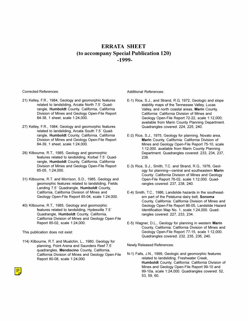
Corrected References:
21) Kelley, F.R., 1984, Geology and geomorphic featuresrelated to landsliding, Arcata North 7.5´ Quad-rangle, Humboldt County, California, CaliforniaDivision of Mines and Geology Open-File Report84-38, 1 sheet, scale 1:24,000.
27) Kelley, F.R., 1984, Geology and geomorphic featuresrelated to landsliding, Arcata South 7.5´ Quad-rangle, Humboldt County, California, CaliforniaDivision of Mines and Geology Open-File Report84-39, 1 sheet, scale 1:24,000.
28) Kilbourne, R.T., 1985, Geology and geomorphicfeatures related to landsliding, Korbel 7.5´ Quad-rangle, Humboldt County, California, CaliforniaDivision of Mines and Geology Open-File Report85-05, 1:24,000.
31) Kilbourne, R.T. and Morrison, S.D., 1985, Geology andgeomorphic features related to landsliding, FieldsLanding 7.5´ Quadrangle, Humboldt County,California, California Division of Mines andGeology Open-File Report 85-04, scale 1:24,000.
40) Kilbourne, R.T., 1985, Geology and geomorphicfeatures related to landsliding, Hydesville 7.5´Quadrangle, Humboldt County, California,California Division of Mines and Geology Open-FileReport 85-02, scale 1:24,000.
This publication does not exist:
114) Kilbourne, R.T. and Mualchin, L., 1980, Geology forplanning, Point Arena and Saunders Reef 7.5´quadrangles, Mendocino County, California,California Division of Mines and Geology Open-FileReport 80-08, scale 1:24,000.
ERRATA SHEET(to accompany Special Publication 120) -1999-
Additional References:
E-1) Rice, S.J., and Strand, R.G, 1972, Geologic and slopestability maps of the Tennessee Valley, LucasValley, and north coastal areas, Marin County,California: California Division of Mines andGeology Open-File Report 72-22, scale 1:12,000;available from Marin County Planning Department.Quadrangles covered: 224, 225, 240.
E-2) Rice, S.J., 1975, Geology for planning, Novato area,Marin County, California: California Division ofMines and Geology Open-File Report 75-10, scale1:12,000. available from Marin County PlanningDepartment. Quadrangles covered: 233, 234, 237,238.
E-3) Rice, S.J., Smith, T.C. and Strand, R.G., 1976, Geol-ogy for planning�central and southeastern MarinCounty: California Division of Mines and GeologyOpen-File Report 76-02, scale 1:12,000. Quad-rangles covered: 237, 238, 240.
E-4) Smith, T.C., 1986, Landslide hazards in the southeast-ern part of the Petaluma dairy belt, SonomaCounty, California: California Division of Mines andGeology Open-File Report 86-05, Landslide HazardIdentification Map No. 1, scale 1:24,000. Quad-rangles covered: 227, 233, 234.
E-5) Wagner, D.L., Geology for planning in western MarinCounty, California: California Division of Mines andGeology Open-File Report 77-15, scale 1:12,000.Quadrangles covered: 232, 235, 236, 240.
Newly Released References:
N-1) Falls, J.N., 1999, Geologic and geomorphic featuresrelated to landsliding, Freshwater Creek,Humboldt County, California: California Division ofMines and Geology Open-File Report 99-10 and99-10a, scale 1:24,000. Quadrangles covered: 52,53, 59, 60.
DMG PUBs
The corrections listed on this page have been made in the electronic version of this publication.
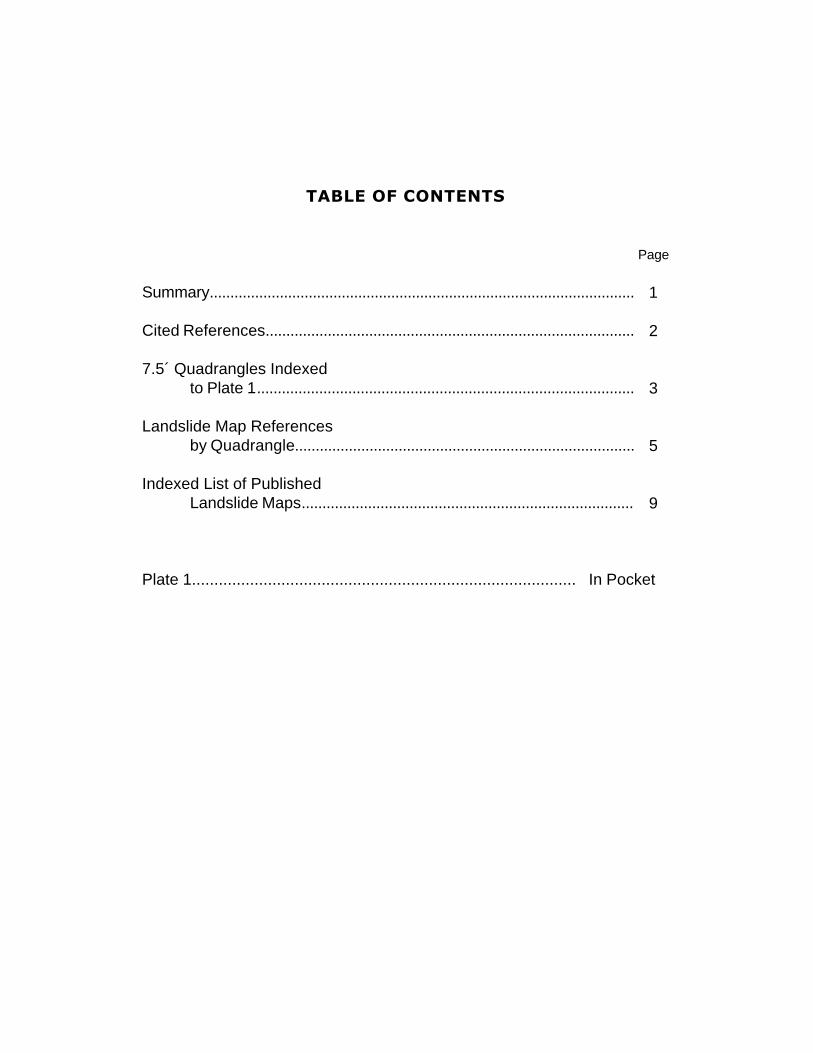
TABLE OF CONTENTS
Page
Summary.......................................................................................................
Cited References.........................................................................................
7.5´ Quadrangles Indexedto Plate 1...........................................................................................
Landslide Map Referencesby Quadrangle..................................................................................
Indexed List of PublishedLandslide Maps................................................................................
Plate 1...................................................................................... In Pocket
1
2
3
5
9

Identifying areas with unstable or potentially unstable slopes is a first step in the management ofland use activities with a goal toward minimizing environmental impacts (Soeters and van Westen,1996). Preparation of landslide maps to aid in timber management on private lands in the northernCalifornia Coast Ranges began in 1979 with the publication of Title II landslide maps prepared by theCalifornia Department of Forestry. These maps were derived from published sources and interpreta-tion of small-scale U-2 aerial imagery. For examples of Title II landslide maps see Durham (1979) andRistau (1979). Systematic mapping of geologic and geomorphic features related to landsliding by theCalifornia Department of Conservation’s Division of Mines and Geology (DMG) was initiated in theearly 1980s. Concurrently, the California Department of Water Resources undertook landslide map-ping in targeted watersheds. These maps were prepared through interpretations of 1:24,000 aerialphotographs flown specifically for the project and field reconnaissance. The purpose of these mapswas to help reduce sedimentation in north coast streams, protect fish habitat, retain productive forestsoils, and provide planning guides for timber harvesting and other forest management activities. For acomplete description of the earlier mapping projects, see Bedrossian (1983 and 1986). Maps preparedby DMG under the Watershed Mapping Project are available on the Department of Conservation’swebsite at: http://www.consrv.ca.gov/dmg/ws/index.htm.
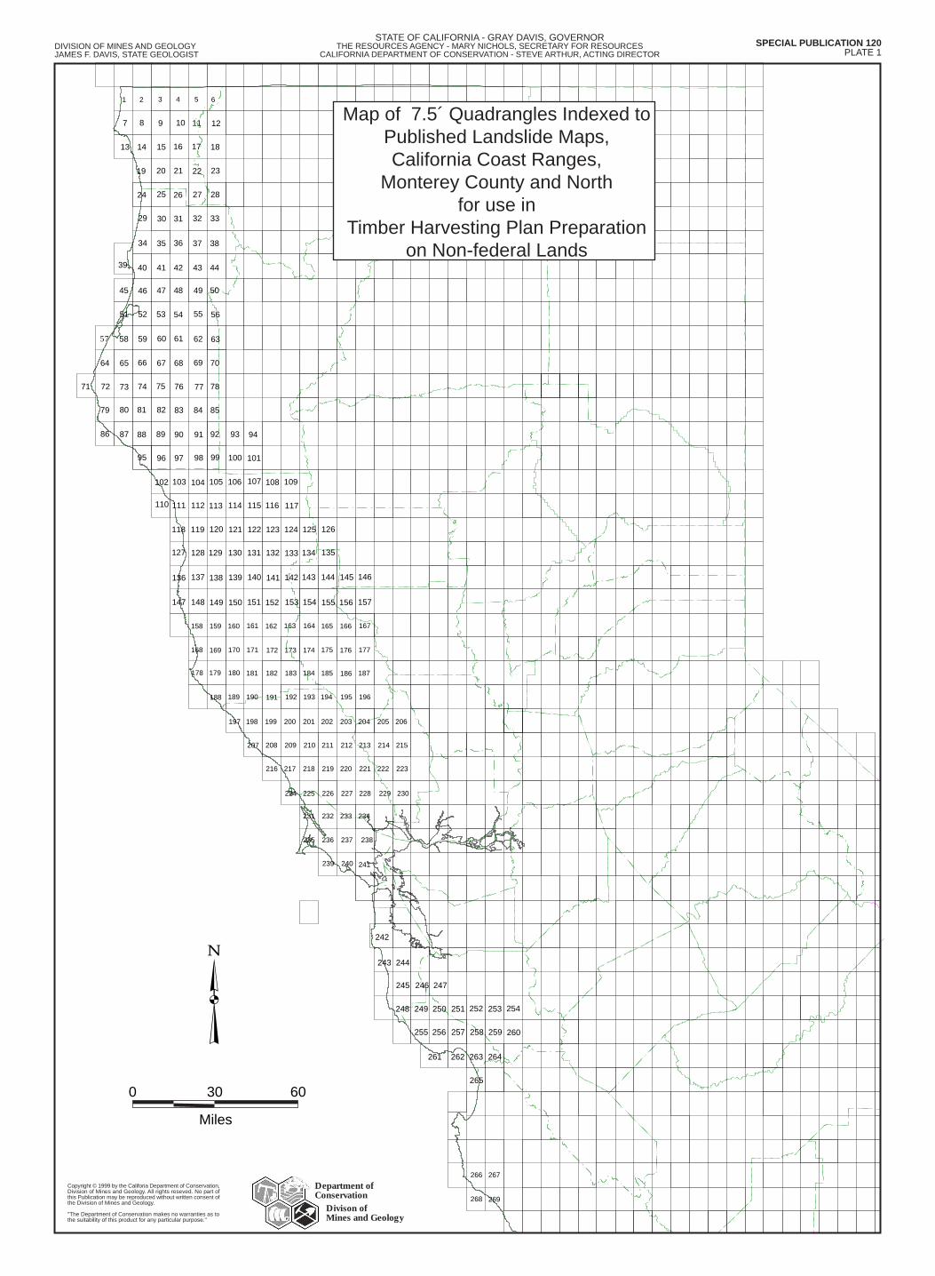
The recent listing of coho salmon and the anticipated listing of steelhead trout as threatenedspecies (Bisson and others, 1997; Working Group of the Watershed Protection and RestorationCouncil, 1998) focuses the need for continued identification of areas where timber harvesting activi-ties and other land uses may increase the incidence of landsliding (Amaranthus and others, 1985;Cafferata and Spittler, 1998; Gray, 1970; Sidel and others, 1985). Although landslide maps may beused for other purposes, this map of 7.5´ quadrangles indexed to published landslide maps (Plate 1)is designed to aid those who prepare or review Timber Harvesting Plans on non-federal lands.
Within the northern California Coast Ranges from Monterey County to the Oregon border, 162publications with landslide maps have been identified for the indexed 7.5´ U.S. Geological Surveytopographic quadrangles where timber harvesting is conducted on private or state-owned lands. Mapsspecific to federal lands are not included in this index because the State does not review timber salesin these areas, and many of the older slope stability maps are no longer available.
Each 7.5´ quadrangle cited in this publication is assigned a reference number that is listed in theindex along with its associated landslide map references. Where landslide maps cover portions ofseveral quadrangles, such as county- or watershed-based maps, the landslide reference is listed oneach quadrangle. Where no landslide maps have been identified for a given quadrangle no refer-ences are listed. These quadrangles are still included in this index so that future map references canbe added. All the landslide maps that cover any portion of a quadrangle in the indexed area areincluded in the listing.
This index does not attempt to designate the relative quality of mapping. However, newer maps atlarge scales typically better represent slope stability conditions than older or smaller-scale maps.These maps are to be used for planning purposes to aid Registered Professional Foresters preparingTimber Harvesting Plans in the disclosure of known landslides or unstable areas. They are also tohelp California licensed geologists and other professionals with studies they may be conductingassociated with timber harvesting operations. This map of quadrangles indexed to published landslidemaps will be updated and expanded as new maps are published.
SUMMARY
1
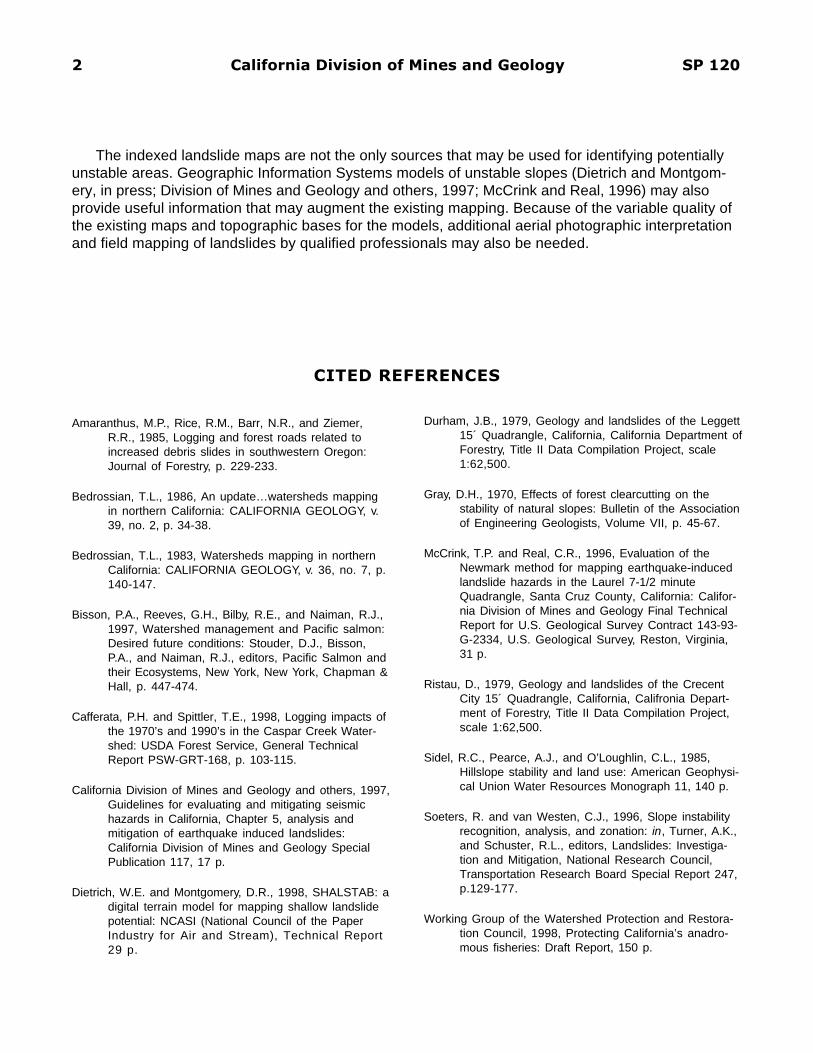
CITED REFERENCES
2 California Division of Mines and Geology SP 120
Amaranthus, M.P., Rice, R.M., Barr, N.R., and Ziemer,R.R., 1985, Logging and forest roads related toincreased debris slides in southwestern Oregon:Journal of Forestry, p. 229-233.
Bedrossian, T.L., 1986, An update…watersheds mappingin northern California: CALIFORNIA GEOLOGY, v.39, no. 2, p. 34-38.
Bedrossian, T.L., 1983, Watersheds mapping in northernCalifornia: CALIFORNIA GEOLOGY, v. 36, no. 7, p.140-147.
Bisson, P.A., Reeves, G.H., Bilby, R.E., and Naiman, R.J.,1997, Watershed management and Pacific salmon:Desired future conditions: Stouder, D.J., Bisson,P.A., and Naiman, R.J., editors, Pacific Salmon andtheir Ecosystems, New York, New York, Chapman &Hall, p. 447-474.
Cafferata, P.H. and Spittler, T.E., 1998, Logging impacts ofthe 1970’s and 1990’s in the Caspar Creek Water-shed: USDA Forest Service, General TechnicalReport PSW-GRT-168, p. 103-115.
California Division of Mines and Geology and others, 1997,Guidelines for evaluating and mitigating seismichazards in California, Chapter 5, analysis andmitigation of earthquake induced landslides:California Division of Mines and Geology SpecialPublication 117, 17 p.
Dietrich, W.E. and Montgomery, D.R., 1998, SHALSTAB: adigital terrain model for mapping shallow landslidepotential: NCASI (National Council of the PaperIndustry for Air and Stream), Technical Report29 p.
Durham, J.B., 1979, Geology and landslides of the Leggett15´ Quadrangle, California, California Department ofForestry, Title II Data Compilation Project, scale1:62,500.
Gray, D.H., 1970, Effects of forest clearcutting on thestability of natural slopes: Bulletin of the Associationof Engineering Geologists, Volume VII, p. 45-67.
McCrink, T.P. and Real, C.R., 1996, Evaluation of theNewmark method for mapping earthquake-inducedlandslide hazards in the Laurel 7-1/2 minuteQuadrangle, Santa Cruz County, California: Califor-nia Division of Mines and Geology Final TechnicalReport for U.S. Geological Survey Contract 143-93-G-2334, U.S. Geological Survey, Reston, Virginia,31 p.
Ristau, D., 1979, Geology and landslides of the CrecentCity 15´ Quadrangle, California, Califronia Depart-ment of Forestry, Title II Data Compilation Project,scale 1:62,500.
Sidel, R.C., Pearce, A.J., and O’Loughlin, C.L., 1985,Hillslope stability and land use: American Geophysi-cal Union Water Resources Monograph 11, 140 p.
Soeters, R. and van Westen, C.J., 1996, Slope instabilityrecognition, analysis, and zonation: in, Turner, A.K.,and Schuster, R.L., editors, Landslides: Investiga-tion and Mitigation, National Research Council,Transportation Research Board Special Report 247,p.129-177.
Working Group of the Watershed Protection and Restora-tion Council, 1998, Protecting California’s anadro-mous fisheries: Draft Report, 150 p.
The indexed landslide maps are not the only sources that may be used for identifying potentiallyunstable areas. Geographic Information Systems models of unstable slopes (Dietrich and Montgom-ery, in press; Division of Mines and Geology and others, 1997; McCrink and Real, 1996) may alsoprovide useful information that may augment the existing mapping. Because of the variable quality ofthe existing maps and topographic bases for the models, additional aerial photographic interpretationand field mapping of landslides by qualified professionals may also be needed.
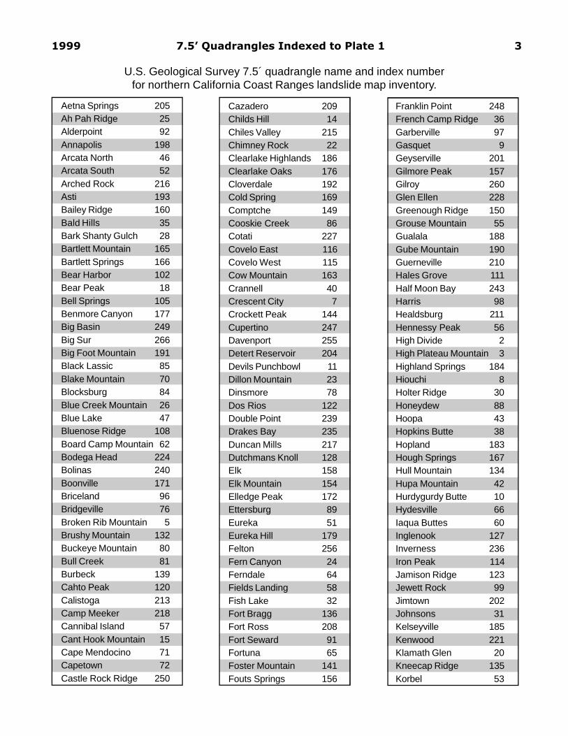
1999 7.5’ Quadrangles Indexed to Plate 1 3
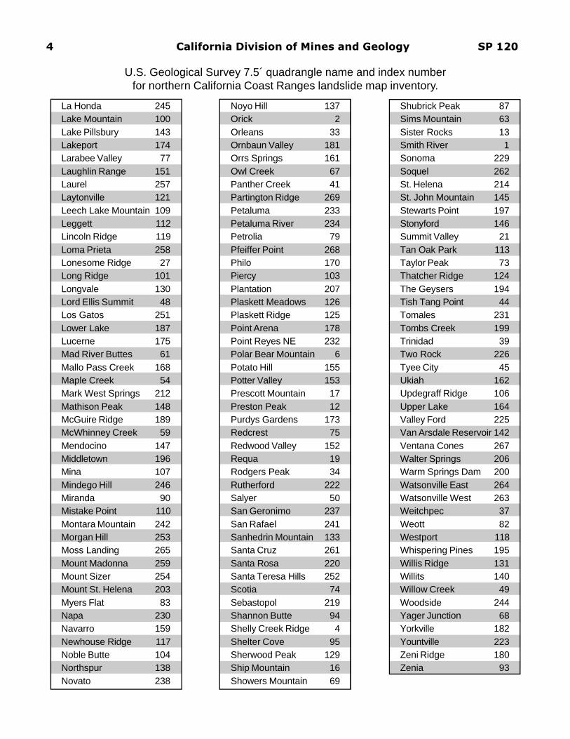
Aetna Springs 205Ah Pah Ridge 25Alderpoint 92Annapolis 198Arcata North 46Arcata South 52Arched Rock 216Asti 193Bailey Ridge 160Bald Hills 35Bark Shanty Gulch 28Bartlett Mountain 165Bartlett Springs 166Bear Harbor 102Bear Peak 18Bell Springs 105Benmore Canyon 177Big Basin 249Big Sur 266Big Foot Mountain 191Black Lassic 85Blake Mountain 70Blocksburg 84Blue Creek Mountain 26Blue Lake 47Bluenose Ridge 108Board Camp Mountain 62Bodega Head 224Bolinas 240Boonville 171Briceland 96Bridgeville 76Broken Rib Mountain 5Brushy Mountain 132Buckeye Mountain 80Bull Creek 81Burbeck 139Cahto Peak 120Calistoga 213Camp Meeker 218Cannibal Island 57Cant Hook Mountain 15Cape Mendocino 71Capetown 72Castle Rock Ridge 250
Cazadero 209Childs Hill 14Chiles Valley 215Chimney Rock 22Clearlake Highlands 186Clearlake Oaks 176Cloverdale 192Cold Spring 169Comptche 149Cooskie Creek 86Cotati 227Covelo East 116Covelo West 115Cow Mountain 163Crannell 40Crescent City 7Crockett Peak 144Cupertino 247Davenport 255Detert Reservoir 204Devils Punchbowl 11Dillon Mountain 23Dinsmore 78Dos Rios 122Double Point 239Drakes Bay 235Duncan Mills 217Dutchmans Knoll 128Elk 158Elk Mountain 154Elledge Peak 172Ettersburg 89Eureka 51Eureka Hill 179Felton 256Fern Canyon 24Ferndale 64Fields Landing 58Fish Lake 32Fort Bragg 136Fort Ross 208Fort Seward 91Fortuna 65Foster Mountain 141Fouts Springs 156
Franklin Point 248French Camp Ridge 36Garberville 97Gasquet 9Geyserville 201Gilmore Peak 157Gilroy 260Glen Ellen 228Greenough Ridge 150Grouse Mountain 55Gualala 188Gube Mountain 190Guerneville 210Hales Grove 111Half Moon Bay 243Harris 98Healdsburg 211Hennessy Peak 56High Divide 2High Plateau Mountain 3Highland Springs 184Hiouchi 8Holter Ridge 30Honeydew 88Hoopa 43Hopkins Butte 38Hopland 183Hough Springs 167Hull Mountain 134Hupa Mountain 42Hurdygurdy Butte 10Hydesville 66Iaqua Buttes 60Inglenook 127Inverness 236Iron Peak 114Jamison Ridge 123Jewett Rock 99Jimtown 202Johnsons 31Kelseyville 185Kenwood 221Klamath Glen 20Kneecap Ridge 135Korbel 53
U.S. Geological Survey 7.5´ quadrangle name and index numberfor northern California Coast Ranges landslide map inventory.
4 California Division of Mines and Geology SP 120
Shubrick Peak 87Sims Mountain 63Sister Rocks 13Smith River 1Sonoma 229Soquel 262St. Helena 214St. John Mountain 145Stewarts Point 197Stonyford 146Summit Valley 21Tan Oak Park 113Taylor Peak 73Thatcher Ridge 124The Geysers 194Tish Tang Point 44Tomales 231Tombs Creek 199Trinidad 39Two Rock 226Tyee City 45Ukiah 162Updegraff Ridge 106Upper Lake 164Valley Ford 225Van Arsdale Reservoir 142Ventana Cones 267Walter Springs 206Warm Springs Dam 200Watsonville East 264Watsonville West 263Weitchpec 37Weott 82Westport 118Whispering Pines 195Willis Ridge 131Willits 140Willow Creek 49Woodside 244Yager Junction 68Yorkville 182Yountville 223Zeni Ridge 180Zenia 93
Noyo Hill 137Orick 2Orleans 33Ornbaun Valley 181Orrs Springs 161Owl Creek 67Panther Creek 41Partington Ridge 269Petaluma 233Petaluma River 234Petrolia 79Pfeiffer Point 268Philo 170Piercy 103Plantation 207Plaskett Meadows 126Plaskett Ridge 125Point Arena 178Point Reyes NE 232Polar Bear Mountain 6Potato Hill 155Potter Valley 153Prescott Mountain 17Preston Peak 12Purdys Gardens 173Redcrest 75Redwood Valley 152Requa 19Rodgers Peak 34Rutherford 222Salyer 50San Geronimo 237San Rafael 241Sanhedrin Mountain 133Santa Cruz 261Santa Rosa 220Santa Teresa Hills 252Scotia 74Sebastopol 219Shannon Butte 94Shelly Creek Ridge 4Shelter Cove 95Sherwood Peak 129Ship Mountain 16Showers Mountain 69
La Honda 245Lake Mountain 100Lake Pillsbury 143Lakeport 174Larabee Valley 77Laughlin Range 151Laurel 257Laytonville 121Leech Lake Mountain 109Leggett 112Lincoln Ridge 119Loma Prieta 258Lonesome Ridge 27Long Ridge 101Longvale 130Lord Ellis Summit 48Los Gatos 251Lower Lake 187Lucerne 175Mad River Buttes 61Mallo Pass Creek 168Maple Creek 54Mark West Springs 212Mathison Peak 148McGuire Ridge 189McWhinney Creek 59Mendocino 147Middletown 196Mina 107Mindego Hill 246Miranda 90Mistake Point 110Montara Mountain 242Morgan Hill 253Moss Landing 265Mount Madonna 259Mount Sizer 254Mount St. Helena 203Myers Flat 83Napa 230Navarro 159Newhouse Ridge 117Noble Butte 104Northspur 138Novato 238
U.S. Geological Survey 7.5´ quadrangle name and index numberfor northern California Coast Ranges landslide map inventory.
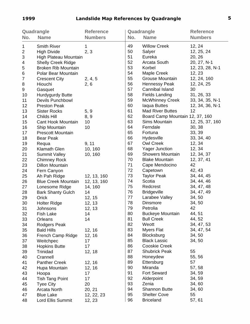
1999 Landslide Map References by Quadrangle
Quadrangle ReferenceNo. Name Numbers
Quadrangle ReferenceNo. Name Numbers
1 Smith River 12 High Divide 2, 33 High Plateau Mountain4 Shelly Creek Ridge5 Broken Rib Mountain6 Polar Bear Mountain7 Crescent City 2, 4, 58 Hiouchi 2, 69 Gasquet10 Hurdygurdy Butte11 Devils Punchbowl12 Preston Peak13 Sister Rocks 5, 914 Childs Hill 8, 915 Cant Hook Mountain 1016 Ship Mountain 1017 Prescott Mountain18 Bear Peak19 Requa 9, 1120 Klamath Glen 10, 16021 Summit Valley 10, 16022 Chimney Rock23 Dillon Mountain24 Fern Canyon25 Ah Pah Ridge 12, 13, 16026 Blue Creek Mountain 12, 13, 16027 Lonesome Ridge 14, 16028 Bark Shanty Gulch 1429 Orick 12, 1530 Holter Ridge 12, 1331 Johnsons 12, 1332 Fish Lake 1433 Orleans 1434 Rodgers Peak35 Bald Hills 12, 1636 French Camp Ridge 12, 1637 Weitchpec 1738 Hopkins Butte 1739 Trinidad 12, 1840 Crannell41 Panther Creek 12, 1642 Hupa Mountain 12, 1643 Hoopa 1744 Tish Tang Point 1745 Tyee City 2046 Arcata North 20, 2147 Blue Lake 12, 22, 2348 Lord Ellis Summit 12, 23
5
49 Willow Creek 12, 2450 Salyer 12, 25, 2451 Eureka 20, 2652 Arcata South 20, 27, N-153 Korbel 12, 23, 28, N-154 Maple Creek 12, 2355 Grouse Mountain 12, 24, 16056 Hennessy Peak 12, 24, 2557 Cannibal Island 3058 Fields Landing 31, 26, 3359 McWhinney Creek 33, 34, 35, N-160 Iaqua Buttes 12, 34, 36, N-161 Mad River Buttes 1262 Board Camp Mountain 12, 37, 16063 Sims Mountain 12, 25, 37, 16064 Ferndale 30, 3865 Fortuna 33, 3966 Hydesville 33, 34, 4067 Owl Creek 12, 3468 Yager Junction 12, 3469 Showers Mountain 12, 34, 3770 Blake Mountain 12, 37, 4171 Cape Mendocino 4272 Capetown 42, 4373 Taylor Peak 34, 44, 4574 Scotia 34, 44, 4675 Redcrest 34, 47, 4876 Bridgeville 34, 47, 4977 Larabee Valley 34, 5078 Dinsmore 34, 5079 Petrolia 4280 Buckeye Mountain 44, 5181 Bull Creek 44, 5282 Weott 34, 47, 5383 Myers Flat 34, 47, 5484 Blocksburg 34, 5085 Black Lassic 34, 5086 Cooskie Creek87 Shubrick Peak 5588 Honeydew 55, 5689 Ettersburg 5790 Miranda 57, 5891 Fort Seward 34, 5992 Alderpoint 34, 5993 Zenia 34, 6094 Shannon Butte 34, 6095 Shelter Cove 5596 Briceland 57, 61

California Division of Mines and Geology SP 120
Quadrangle ReferenceNo. Name Numbers
Quadrangle ReferenceNo. Name Numbers
6
97 Garberville 57, 6298 Harris 59, 6399 Jewett Rock 59100 Lake Mountain 34, 60101 Long Ridge 34, 60102 Bear Harbor 64103 Piercy 64, 65104 Noble Butte 66, 67105 Bell Springs 67106 Updegraff Ridge 19107 Mina 19108 Bluenose Ridge109 Leech Lake Mountain110 Mistake Point 64111 Hales Grove 64, 68112 Leggett 67, 69113 Tan Oak Park 67, 70114 Iron Peak 19, 71115 Covelo West 19, 72116 Covelo East 72117 Newhouse Ridge118 Westport 73, 74119 Lincoln Ridge 75, 76120 Cahto Peak 75, 77121 Laytonville 78, 79122 Dos Rios 78123 Jamison Ridge 80124 Thatcher Ridge 80125 Plaskett Ridge 81126 Plaskett Meadows 81127 Inglenook 73, 82128 Dutchmans Knoll 75, 83129 Sherwood Peak 75, 84130 Longvale 78, 85131 Willis Ridge 78132 Brushy Mountain 80133 Sanhedrin Mountain 80134 Hull Mountain 81135 Kneecap Ridge 81136 Fort Bragg 86, 87137 Noyo Hill 88, 89, 90138 Northspur 90, 91139 Burbeck 92, 93140 Willits 92141 Foster Mountain 94142 Van Arsdale Reservoir 94, 103143 Lake Pillsbury 95144 Crockett Peak 95
145 St. John Mountain146 Stonyford147 Mendocino 87, 90, 96148 Mathison Peak 90, 97149 Comptche 90, 98150 Greenough Ridge 92, 99151 Laughlin Range 92152 Redwood Valley 94153 Potter Valley 94154 Elk Mountain 95155 Potato Hill 95156 Fouts Springs157 Gilmore Peak158 Elk 100, 101159 Navarro 100, 102160 Bailey Ridge 103, 104161 Orrs Springs 103162 Ukiah 105, 106163 Cow Mountain 105, 107, 108164 Upper Lake 109165 Bartlett Mountain 109166 Bartlett Springs167 Hough Springs168 Mallo Pass Creek 100, 110169 Cold Spring 100, 111170 Philo 103, 161171 Boonville 103172 Elledge Peak 105173 Purdys Gardens 105174 Lakeport 109175 Lucerne 109, 162176 Clearlake Oaks 162177 Benmore Canyon 162178 Point Arena 112, 113179 Eureka Hill 113, 115, 116180 Zeni Ridge 117, 118181 Ornbaun Valley 117182 Yorkville 119, 120183 Hopland 119, 120184 Highland Springs 120, 121185 Kelseyville 120, 121186 Clearlake Highlands 122187 Lower Lake 122188 Gualala 113, 118, 123,
124, 125, 127189 McGuire Ridge 117, 123, 125,
127, 129190 Gube Mountain 117, 123, 127

1999 Landslide Map References by Quadrangle
Quadrangle ReferenceNo. Name Numbers
Quadrangle ReferenceNo. Name Numbers
7
191 Big Foot Mountain 119, 120, 123,127, 130
192 Cloverdale 119, 120, 123,127, 130
193 Asti 29, 120, 121, 123,127, 130
194 The Geysers 29, 107, 120, 121,123, 127, 130
195 Whispering Pines 29, 122, 123, 127,130
196 Middletown 122, 127197 Stewarts Point 123, 125, 127,
131198 Annapolis 123, 127199 Tombs Creek 123, 135, 127200 Warm Springs Dam 123, 127, 135201 Geyserville 29, 123, 127, 126202 Jimtown 29, 123, 127, 126203 Mount St. Helena 32, 123, 127, 135204 Detert Reservoir 32, 127, 135205 Aetna Springs 127, 128, 135206 Walter Springs 127, 128, 135207 Plantation 123, 125, 127,
131208 Fort Ross 123, 127, 135209 Cazadero 123, 127, 135210 Guerneville 123, 126211 Healdsburg 123, 126, 127212 Mark West Springs 32, 123, 127, 135213 Calistoga 32, 123, 127, 135214 St. Helena 29, 127, 135, 128215 Chiles Valley 127, 135, 128216 Arched Rock 123, 125, 127,
131217 Duncan Mills 123, 125, 127,
133218 Camp Meeker 123, 127, 132219 Sebastopol 123, 127, 132,
158220 Santa Rosa 123, 127, 134,
135221 Kenwood 123, 127, 134,
135222 Rutherford 123, 127, 135223 Yountville 127, 135,224 Bodega Head 123, 125, 127,
131, 133, E-1225 Valley Ford 123, 125, 127,
132, 133, E-1
226 Two Rock 123, 127, 132227 Cotati 123, 127, 134,
135, E-4228 Glen Ellen 123, 127, 134,
135229 Sonoma 123, 127, 135230 Napa 127, 135231 Tomales 125, 127, 131,
133, 136, 137232 Point Reyes NE 123, 127, 136,
137, E-5233 Petaluma 123, 127, 136,
137, E-2, E-4234 Petaluma River 123, 127, 136,
137, 138, E-2, E-4235 Drakes Bay 127, 131, 136,
137, E-5236 Inverness 127, 136, 137, E-5237 San Geronimo 127, 136, 137,
138, E-2, E-3238 Novato 127, 136, 137,
138, E-2, E-3239 Double Point 127, 137240 Bolinas 127, 136, 137, E-1,
E-3, E-5241 San Rafael 127, 136, 137, 138242 Montara Mountain 127, 139, 140,
141, 142, 143243 Half Moon Bay 127, 139, 140,
141244 Woodside 127, 139, 140,
141, 144245 La Honda 127, 139, 140,
141, 145246 Mindego Hill 127, 139, 140,
141, 146, 147247 Cupertino 127, 141, 146,
148248 Franklin Point 127, 139, 140,
141, 149, 150,151
249 Big Basin 7, 127, 139, 140,141, 146, 149,159
250 Castle Rock Ridge 127, 141, 146,149, 151, 157
251 Los Gatos 127, 146, 151252 Santa Teresa Hills 127, 152, 153253 Morgan Hill 127, 152
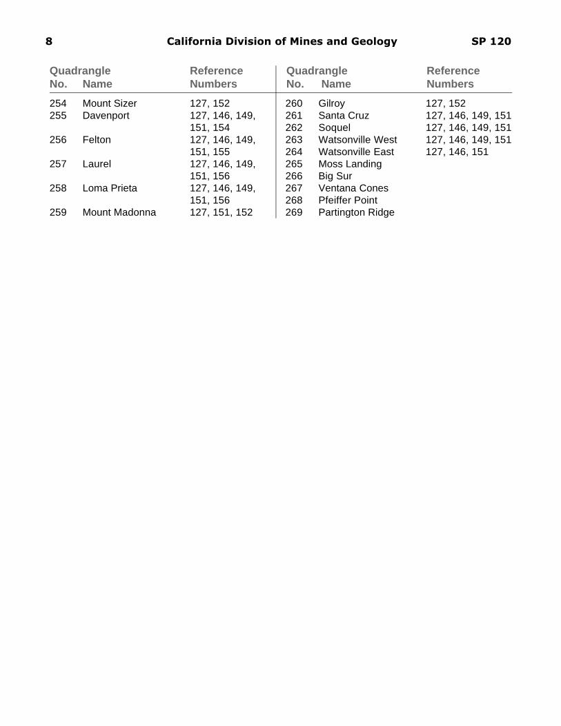
California Division of Mines and Geology SP 120
Quadrangle ReferenceNo. Name Numbers
Quadrangle ReferenceNo. Name Numbers
8
254 Mount Sizer 127, 152255 Davenport 127, 146, 149,
151, 154256 Felton 127, 146, 149,
151, 155257 Laurel 127, 146, 149,
151, 156258 Loma Prieta 127, 146, 149,
151, 156259 Mount Madonna 127, 151, 152
260 Gilroy 127, 152261 Santa Cruz 127, 146, 149, 151262 Soquel 127, 146, 149, 151263 Watsonville West 127, 146, 149, 151264 Watsonville East 127, 146, 151265 Moss Landing266 Big Sur267 Ventana Cones268 Pfeiffer Point269 Partington Ridge

1999 Indexed List of Published Landslide Maps 9
1) Davenport, C.W., 1983, Geology and geomorphic features related to landsliding, Smith River 7.5´Quadrangle, Del Norte County, California, California Division of Mines and Geology Open-FileReport 83-19, scale 1:24,000.
2) Ristau, D., 1979, Geology and landslides of the Crescent City 15´ Quadrangle, California, CaliforniaDepartment of Forestry, Title II Data Compilation Project, scale 1:62,500.
3) Davenport, C.W., 1983, Geology and geomorphic features related to landsliding, part of the HighDivide 7.5´ Quadrangle, Del Norte County, California, California Division of Mines and GeologyOpen-File Report 83-18, scale 1:24,000.
4) Davenport, C.W., 1982, Geology and geomorphic features related to landsliding, Crescent City 7.5´Quadrangle, Del Norte County, California, California Division of Mines and Geology Open-FileReport 82-21, scale 1:24,000.
5) Kilbourne, R.T. and Maulchin, L., 1981, Geology for planning, Crescent City and Sister Rocks 7.5´quadrangles, Del Norte County, California, California Division of Mines and Geology Open-FileReport 81-01, 1:24,000.
6) Davenport, C.W., 1983, Geology and geomorphic features related to landsliding, Hiouchi 7.5´Quadrangle, Del Norte County, California, California Division of Mines and Geology Open-FileReport 83-04, scale 1:24,000.
7) Pulver, B.S., 1979, Geology and landslides of the Big Basin 7.5´ Quadrangle, California, CaliforniaDepartment of Forestry, Title II Data Compilation Project, scale 1:24,000.
8) Davenport, C.W., 1984, Geology and geomorphic features related to landsliding, Childs Hill 7.5´Quadrangle, Del Norte County, California, California Division of Mines and Geology Open-FileReport 84-07, scale 1:24,000.
9) Ristau, D., 1979, Geology and landslides of the Klamath 15´ Quadrangle, California, CaliforniaDepartment of Forestry, Title II Data Compilation Project, scale 1:62,500.
10) Ristau, D., 1979, Geology and landslides of the Ship Mountain 15´ Quadrangle, California, Califor-nia Department of Forestry, Title II Data Compilation Project, scale 1:62,500.
11) Davenport, C.W., 1984, Geology and geomorphic features related to landsliding, Requa 7.5´Quadrangle, Del Norte County, California, California Division of Mines and Geology Open-FileReport 84-08, scale 1:24,000.
12) Nolan, K.M., Harden, D.R., and Colman, S.M., 1976, Erosional landform map of the RedwoodCreek Drainage Basin, Humboldt County, California, 1947-74, U.S. Geological Survey Water-Resources Investigations Open-File Report 76-42, scale 1:62,500.
13) Ristau, D., 1979, Geology and landslides of the Tectah Creek 15´ Quadrangle, California, Califor-nia Department of Forestry, Title II Data Compilation Project, scale 1:62,500.
14) Ristau, D., 1979, Geology and landslides of the Orleans 15´ Quadrangle, California, CaliforniaDepartment of Forestry, Title II Data Compilation Project, scale 1:62,500.
15) Ristau, D., 1979, Geology and landslides of the Orick 15´ Quadrangle, California, CaliforniaDepartment of Forestry, Title II Data Compilation Project, scale 1:62,500.
California Division of Mines and Geology SP 12010
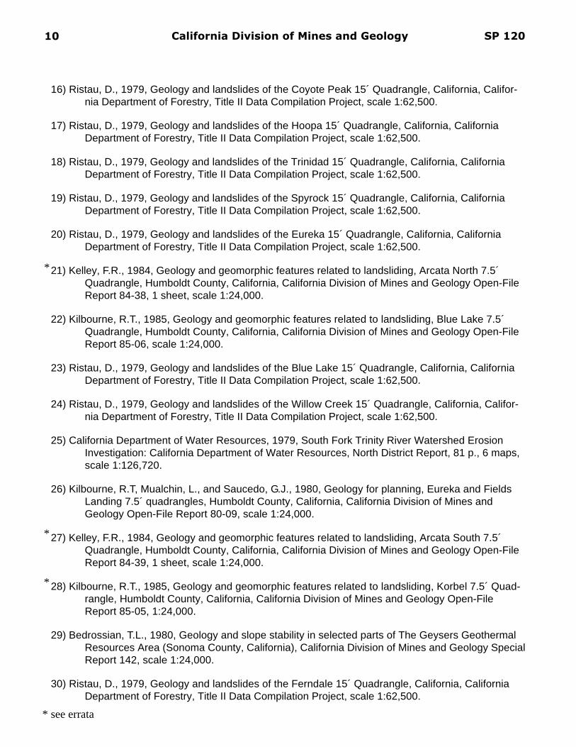
16) Ristau, D., 1979, Geology and landslides of the Coyote Peak 15´ Quadrangle, California, Califor-nia Department of Forestry, Title II Data Compilation Project, scale 1:62,500.
17) Ristau, D., 1979, Geology and landslides of the Hoopa 15´ Quadrangle, California, CaliforniaDepartment of Forestry, Title II Data Compilation Project, scale 1:62,500.
18) Ristau, D., 1979, Geology and landslides of the Trinidad 15´ Quadrangle, California, CaliforniaDepartment of Forestry, Title II Data Compilation Project, scale 1:62,500.
19) Ristau, D., 1979, Geology and landslides of the Spyrock 15´ Quadrangle, California, CaliforniaDepartment of Forestry, Title II Data Compilation Project, scale 1:62,500.
20) Ristau, D., 1979, Geology and landslides of the Eureka 15´ Quadrangle, California, CaliforniaDepartment of Forestry, Title II Data Compilation Project, scale 1:62,500.
21) Kelley, F.R., 1984, Geology and geomorphic features related to landsliding, Arcata North 7.5´Quadrangle, Humboldt County, California, California Division of Mines and Geology Open-FileReport 84-38, 1 sheet, scale 1:24,000.
22) Kilbourne, R.T., 1985, Geology and geomorphic features related to landsliding, Blue Lake 7.5´Quadrangle, Humboldt County, California, California Division of Mines and Geology Open-FileReport 85-06, scale 1:24,000.
23) Ristau, D., 1979, Geology and landslides of the Blue Lake 15´ Quadrangle, California, CaliforniaDepartment of Forestry, Title II Data Compilation Project, scale 1:62,500.
24) Ristau, D., 1979, Geology and landslides of the Willow Creek 15´ Quadrangle, California, Califor-nia Department of Forestry, Title II Data Compilation Project, scale 1:62,500.
25) California Department of Water Resources, 1979, South Fork Trinity River Watershed ErosionInvestigation: California Department of Water Resources, North District Report, 81 p., 6 maps,scale 1:126,720.
26) Kilbourne, R.T, Mualchin, L., and Saucedo, G.J., 1980, Geology for planning, Eureka and FieldsLanding 7.5´ quadrangles, Humboldt County, California, California Division of Mines andGeology Open-File Report 80-09, scale 1:24,000.
27) Kelley, F.R., 1984, Geology and geomorphic features related to landsliding, Arcata South 7.5´Quadrangle, Humboldt County, California, California Division of Mines and Geology Open-FileReport 84-39, 1 sheet, scale 1:24,000.
28) Kilbourne, R.T., 1985, Geology and geomorphic features related to landsliding, Korbel 7.5´ Quad-rangle, Humboldt County, California, California Division of Mines and Geology Open-FileReport 85-05, 1:24,000.
29) Bedrossian, T.L., 1980, Geology and slope stability in selected parts of The Geysers GeothermalResources Area (Sonoma County, California), California Division of Mines and Geology SpecialReport 142, scale 1:24,000.
30) Ristau, D., 1979, Geology and landslides of the Ferndale 15´ Quadrangle, California, CaliforniaDepartment of Forestry, Title II Data Compilation Project, scale 1:62,500.
*
*
*
* see errata
1999 Indexed List of Published Landslide Maps 11
31) Kilbourne, R.T. and Morrison, S.D., 1985, Geology and geomorphic features related to landsliding,Fields Landing 7.5´ Quadrangle, Humboldt County, California, California Division of Minesand Geology Open-File Report 85-04, scale 1:24,000.
32) Durham, J.B., 1979, Geology and landslides of the Calistoga 15´ Quadrangle, California, Califor-nia Department of Forestry, Title II Data Compilation Project, scale 1:62,500.
33) Ristau, D., 1979, Geology and landslides of the Fortuna 15´ Quadrangle, California, CaliforniaDepartment of Forestry, Title II Data Compilation Project, scale 1:62,500.
34) Kelsey, H.M. and Allwardt, A.O., 1975, Slope classification map: Van Duzen River Basin: Humboldt& Trinity counties, California, in, Van Duzen River Basin environmental atlas, State of Califor-nia, The Resources Agency, Department of Water Resources, plate 9, scale 1:35,736.
35) Kilbourne, R.T., Geology and geomorphic features related to landsliding, McWhinney Creek 7.5´Quadrangle, Humboldt County, California, California Division of Mines and Geology Open-FileReport 85-03, scale 1:24,000.
36) Ristau, D., 1979, Geology and landslides of the Iaqua Buttes 15´ Quadrangle, California, Califor-nia Department of Forestry, Title II Data Compilation Project, scale 1:62,500.
37) Ristau, D., 1979, Geology and landslides of the Pilot Creek 15´ Quadrangle, California, CaliforniaDepartment of Forestry, Title II Data Compilation Project, scale 1:62,500.
38) Spittler, T.E., 1984, Geology and geomorphic features related to landsliding, Ferndale 7.5´ Quad-rangle, Humboldt County, California, California Division of Mines and Geology Open-FileReport 84-35, scale 1:24,000.
39) Kilbourne, R.T., 1985, Geology and geomorphic features related to landsliding, Fortuna 7.5´Quadrangle, Humboldt County, California, California Division of Mines and Geology Open-FileReport 85-01, 1 sheet, scale 1:24,000.
40) Kilbourne, R.T., 1985, Geology and geomorphic features related to landsliding, Hydesville 7.5´Quadrangle, Humboldt County, California, California Division of Mines and Geology Open-FileReport 85-02, scale 1:24,000.
41) California Department of Water Resources, 1979, South Fork Trinity River watershed erosioninvestigation: California Department of Water Resources, North District Report, 81 p., 6 maps,scale 1:126,720.
42) Ristau, D., 1979, Geology and landslides of the Cape Mendocino 15´ Quadrangle, California,California Department of Forestry, Title II Data Compilation Project, scale 1:62,500.
43) Spittler, T.E., 1984, Geology and geomorphic features related to landsliding, Capetown 7.5´ Quad-rangle, Humboldt County, California, California Division of Mines and Geology Open-FileReport 84-34, scale 1:24,000.
44) Ristau, D., 1979, Geology and landslides of the Scotia 15´ Quadrangle, California, CaliforniaDepartment of Forestry, Title II Data Compilation Project, scale 1:62,500.
*
* see errata
*
California Division of Mines and Geology SP 12012
45) Spittler, T.E., 1982, Geology and geomorphic features related to landsliding, Taylor Peak 7.5´Quadrangle, Humboldt County, California, California Division of Mines and Geology Open-FileReport 84-36, scale 1:24,000.
46) Spittler, T.E., 1982, Geology and geomorphic features related to landsliding, Scotia 7.5´ Quad-rangle, Humboldt County, California, California Division of Mines and Geology Open-FileReport 82-20, 1 sheet, scale 1:24,000.
47) Ristau, D., 1979, Geology and landslides of the Weott 15´ Quadrangle, California, CaliforniaDepartment of Forestry, Title II Data Compilation Project, scale 1:62,500
48) Spittler, T.E., 1983, Geology and geomorphic features related to landsliding, Redcrest 7.5´ Quad-rangle, Humboldt County, California, California Division of Mines and Geology Open-FileReport 83-17, scale 1:24,000.
49) Spittler, T.E., 1983, Geology and geomorphic features related to landsliding, Bridgeville 7.5´Quadrangle, Humboldt County, California, California Division of Mines and Geology Open-FileReport 83-23, scale 1:24,000.
50) Ristau, D., 1979, Geology and landslides of the Blocksburg 15´ Quadrangle, California, CaliforniaDepartment of Forestry, Title II Data Compilation Project, scale 1:62,500.
51) Spittler, T.E., 1984, Geology and geomorphic features related to landsliding, Buckeye Mountain7.5´ Quadrangle, Humboldt County, California, California Division of Mines and Geology Open-File Report 84-37, 1 sheet, scale 1:24,000.
52) Spittler, T.E., 1983, Geology and geomorphic features related to landsliding, Bull Creek 7.5´Quadrangle, Humboldt County, California, California Division of Mines and Geology Open-FileReport 83-3, scale 1:24,000.
53) Spittler, T.E., 1983, Geology and geomorphic features related to landsliding, Weott 7.5´ Quad-rangle, Humboldt County, California, California Division of Mines and Geology Open-FileReport 83-06, scale 1:24,000.
54) Spittler, T.E., 1983, Geology and geomorphic features related to landsliding, Myers Flat 7.5´Quadrangle, Humboldt County, California, California Division of Mines and Geology Open-FileReport 83-22, scale 1:24,000.
55) Ristau, D., 1979, Geology and landslides of the Point Delgada 15´ Quadrangle, California, Califor-nia Department of Forestry, Title II Data Compilation Project, scale 1:62,500.
56) Spittler, T.E., 1984, Geology and geomorphic features related to landsliding, Honeydew 7.5´Quadrangle, Humboldt County, California, California Division of Mines and Geology Open-FileReport 84-11, 1 sheet, scale 1:24,000.
57) Ristau, D., 1979, Geology and landslides of the Garberville 15´ Quadrangle, California, CaliforniaDepartment of Forestry, Title II Data Compilation Project, scale 1:62,500.
58) Spittler, T.E., 1983, Geology and geomorphic features related to landsliding, Miranda 7.5´ Quad-rangle, Humboldt County, California, California Division of Mines and Geology Open-FileReport 83-25, scale 1:24,000.

1999 Indexed List of Published Landslide Maps 13
59) Ristau, D., 1979, Geology and landslides of the Alderpoint 15´ Quadrangle, California, CaliforniaDepartment of Forestry, Title II Data Compilation Project, scale 1:62,500.
60) Ristau, D., 1979, Geology and landslides of the Kettenpom 15´ Quadrangle, California, CaliforniaDepartment of Forestry, Title II Data Compilation Project, scale 1:62,500.
61) Spittler, T.E., 1984, Geology and geomorphic features related to landsliding, Briceland 7.5´ Quad-rangle, Humboldt County, California, California Division of Mines and Geology Open-FileReport 84-10, scale 1:24,000.
62) Spittler, T.E., 1983, Geology and geomorphic features related to landsliding, Garberville 7.5´Quadrangle, Humboldt County, California, California Division of Mines and Geology Open-FileReport 83-26, scale 1:24,000.
63) Spittler, T.E., 1984, Geology and geomorphic features related to landsliding, Harris 7.5´ Quad-rangle, Humboldt County, California, California Division of Mines and Geology Open-FileReport 84-09, 1 sheet, scale 1:24,000.
64) Durham, J.B., 1979, Geology and landslides of the Piercy 15´ Quadrangle, California, CaliforniaDepartment of Forestry, Title II Data Compilation Project, scale 1:62,500.
65) Kelley, F.R., 1984, Geology and geomorphic features related to landsliding, Piercy 7.5´ Quad-rangle, Mendocino County, California, California Division of Mines and Geology Open-FileReport 84-16, 1 sheet, scale 1:24,000.
66) Davenport, C.W., 1983, Geology and geomorphic features related to landsliding, Noble Butte 7.5´Quadrangle, Mendocino County, California, California Division of Mines and Geology Open-FileReport 83-41, scale 1:24,000.
67) Durham, J.B., 1979, Geology and landslides of the Leggett 15´ Quadrangle, California, CaliforniaDepartment of Forestry, Title II Data Compilation Project, scale 1:62,500.
68) Kelley, F.R., 1984, Geology and geomorphic features related to landsliding, Hales Grove 7.5´Quadrangle, Mendocino County, California, California Division of Mines and Geology Open-FileReport 84-15, scale 1:24,000.
69) Davenport, C.W., 1983, Geology and geomorphic features related to landsliding, Leggett 7.5´Quadrangle, Mendocino County, California, California Division of Mines and Geology Open-FileReport 83-40, scale 1:24,000.
70) Davenport, C.W., 1984, Geology and geomorphic features related to landsliding, Tan Oak Park7.5´ Quadrangle, Mendocino County, California, California Division of Mines and GeologyOpen-File Report 84-17, scale 1:24,000.
71) Kilbourne, R.T., 1984, Geology and geomorphic features related to landsliding, Iron Peak Quad-rangle, Mendocino County, California, California Division of Mines and Geology Open-FileReport 84-40, scale 1:24,000.
72) Durham, J.B., 1979, Geology and landslides of the Covelo 15´ Quadrangle, California, CaliforniaDepartment of Forestry, Title II Data Compilation Project, scale 1:62,500.

California Division of Mines and Geology SP 12014
73) Durham, J.B., 1979, Geology and landslides of the Cape Vizcaino 15´ Quadrangle, California,California Department of Forestry, Title II Data Compilation Project, scale 1:62,500.
74) Kelley, F.R., 1983, Geology and geomorphic features related to landsliding, Westport 7.5´ Quad-rangle, Mendocino County, California, California Division of Mines and Geology Open-FileReport 83-32, scale 1:24,000.
75) Durham, J.B., 1979, Geology and landslides of the Branscomb 15´ Quadrangle, California, Califor-nia Department of Forestry, Title II Data Compilation Project, scale 1:62,500.
76) Kelley, F.R., 1984, Geology and geomorphic features related to landsliding, Lincoln Ridge 7.5‘Quadrangle, Mendocino County, California, California Division of Mines and Geology Open-FileReport 84-14, 1 sheet, scale 1:24,000.
77) Kilbourne, R.T., 1983, Geology and geomorphic features related to landsliding, Cahto Peak 7.5´Quadrangle, Mendocino County, California, California Division of Mines and Geology Open-FileReport 83-39, scale 1:24,000.
78) Durham, J.B., 1979, Geology and landslides of the Laytonville 15´ Quadrangle, California, Califor-nia Department of Forestry, Title II Data Compilation Project, scale 1:62,500.
79) Kilbourne, R.T., 1984, Geology and geomorphic features related to landsliding, Laytonville Quad-rangle, Mendocino County, California, California Division of Mines and Geology Open-FileReport 84-41, scale 1:24,000.
80) Durham, J.B., 1979, Geology and landslides of the Eden Valley 15´ Quadrangle, California, Cali-fornia Department of Forestry, Title II Data Compilation Project, scale 1:62,500.
81) Durham, J.B., 1979, Geology and landslides of the Hull Mountain 15´ Quadrangle, California,California Department of Forestry, Title II Data Compilation Project, scale 1:62,500.
82) Kelley, F.R., 1983, Geology and geomorphic features related to landsliding, Inglenook 7.5´ Quad-rangle, Mendocino County, California, California Division of Mines and Geology Open-FileReport 83-31, scale 1:24,000.
83) Kelley, F.R., 1983, Geology and geomorphic features related to landsliding, Dutchmans Knoll 7.5´Quadrangle, Mendocino County, California, California Division of Mines and Geology Open-FileReport 83-33, scale 1:24,000.
84) Kilbourne, R.T., 1983, Geology and geomorphic features related to landsliding, Sherwood Peak7.5´ Quadrangle, Mendocino County, California, California Division of Mines and GeologyOpen-File Report 83-38, 1 sheet, scale 1:24,000.
85) Kilbourne, R.T., 1984, Geology and geomorphic features related to landsliding, Longvale 7.5´Quadrangle, Mendocino County, California, California Division of Mines and Geology Open-FileReport 84-18, scale 1:24,000.
86) Kilbourne, R.T., 1983, Geology and geomorphic features related to landsliding, Fort Bragg 7.5´Quadrangle, Mendocino County, California, California Division of Mines and Geology Open-FileReport 83-5, scale 1:24,000.

1999 Indexed List of Published Landslide Maps 15
87) Durham, J.B., 1979, Geology and landslides of the Fort Bragg 15´ Quadrangle, California, Califor-nia Department of Forestry, Title II Data Compilation Project, scale 1:62,500.
88) Durham, J.B., 1979, Geology and landslides of the Comptche 15´ Quadrangle, California, Califor-nia Department of Forestry, Title II Data Compilation Project, scale 1:62,500.
89) Kilbourne, R.T., Geology and geomorphic features related to landsliding, Glenblair NW (Noyo Hill)7.5´ Quadrangle, Mendocino County, California, California Division of Mines and GeologyOpen-File Report 82-25, scale 1:24,000.
90) Spittler, T.E. and McKittrick, M.A., Geologic and geomorphic features related to landsliding, Northand South Forks of Casper Creek, Mendocino County, California, California Division of Minesand Geology Open-File Report 95-08, scale 1:12,000.
91) Kilbourne, R.T., 1983, Geology and geomorphic features related to landsliding, Glenblair NE(Northspur) 7.5´ Quadrangle, Mendocino County, California, California Division of Mines andGeology Open-File Report 82-19, scale 1:24,000.
92) Durham, J.B., 1979, Geology and landslides of the Noyo 15´ Quadrangle, California, CaliforniaDepartment of Forestry, Title II Data Compilation Project, scale 1:62,500.
93) Kilbourne, R.T., 1984, Geology and geomorphic features related to landsliding, Willits NW(Burbeck) 7.5´ Quadrangle, Mendocino County, California, California Division of Mines andGeology Open-File Report 84-19, scale 1:24,000.
94) Durham, J.B., 1979, Geology and landslides of the Potter Valley 15´ Quadrangle, California,California Department of Forestry, Title II Data Compilation Project, scale 1:62,500.
95) Durham, J.B., 1979, Geology and landslides of the Lake Pillsbury 15´ Quadrangle, California,California Department of Forestry, Title II Data Compilation Project, scale 1:62,500.
96) Kilbourne, R.T., 1983, Geology and geomorphic features related to landsliding, Mendocino 7.5´Quadrangle, Mendocino County, California, California Division of Mines and Geology Open-FileReport 83-15, scale 1:24,000.
97) Kilbourne, R.T., 1983, Geology and Geomorphic features related to landsliding, Glenblair SW(Mathison Peak) 7.5´ Quadrangle, Mendocino County, California, California Division of Minesand Geology Open-File Report 83-20, scale 1:24,000.
98) Kilbourne, R.T., 1983, Geology and Geomorphic features related to landsliding, Glenblair SE(Comptche) 7.5´ Quadrangle, Mendocino County, California, California Division of Mines andGeology Open-File Report 83-21, scale 1:24,000.
99) Kilbourne, R.T., 1984, Geology and geomorphic features related to landsliding, Willits SW 7.5´Quadrangle, Mendocino County, California, California Division of Mines and Geology Open-FileReport 84-20, scale 1:24,000.
100) Durham, J.B., 1979, Geology and landslides of the Navarro 15´ Quadrangle, California, Califor-nia Department of Forestry, Title II Data Compilation Project, scale 1:62,500.

California Division of Mines and Geology SP 12016
101) Manson, M.W., 1984, Geology and geomorphic features related to landsliding, Elk 7.5´ Quad-rangle, Mendocino County, California, California Division of Mines and Geology Open-FileReport 84-12, scale 1:24,000.
102) Manson, M.W., 1984, Geology and geomorphic features related to landsliding, Navarro NE 7.5´Quadrangle, Mendocino County, California, California Division of Mines and Geology Open-FileReport 84-44, scale 1:24,000.
103) Durham, J.B., 1979, Geology and landslides of the Boonville 15´ Quadrangle, California, Califor-nia Department of Forestry, Title II Data Compilation Project, scale 1:62,500.
104) Kilbourne, R.T., 1984, Geology and geomorphic features related to landsliding, Boonville NW7.5´ Quadrangle, Mendocino County, California, California Division of Mines and GeologyOpen-File Report 84-42, scale 1:24,000.
105) Durham, J.B., 1979, Geology and landslides of the Ukiah 15´ Quadrangle, California, CaliforniaDepartment of Forestry, Title II Data Compilation Project, scale 1:62,500.
106) Sydnor, R.H. and Sowma-Bawcom, J. A., 1991 Landslide and engineering geology of the West-ern Ukiah Area, Central Mendocino County, California, Landslide Hazard Identification Map No.24, California Division of Mines and Geology Open-File Report 91-16, scale 1:6,000.
107) Dwyer, M.J., and Noguchi, N., 1976, Regional landslide map, Geysers-Cow Mountain studyareas, Mendocino, Lake, and Sonoma counties, California, Cooper-Clark and Associates,report for U.S. Bureau of Land Management, contract no. YA-512-LT6-83, Ukiah District Office,8 plates, scale 1:12,000.
108) Rymer, M.J. and Sims, J.D., 1975, Preliminary photo interpretation map of landslides and othersurficial deposits in the Cow Mountain 7.5´ Quadrangle, Lake and Mendocino counties, Califor-nia, U.S. Geological Survey Miscellaneous Field Studies Map MF-680, scale 1:24,000.
109) Durham, J.B., 1979, Geology and landslides of the Lakeport 15´ Quadrangle, California, Califor-nia Department of Forestry, Title II Data Compilation Project, scale 1:62,500.
110) Manson, M.W., 1984, Geology and geomorphic features related to landsliding, Mallow PassCreek 7.5´ Quadrangle, Mendocino County, California, California Division of Mines and Geol-ogy Open-File Report 84-13, scale 1:24,000.
111) Manson, M.W., 1984, Geology and geomorphic features related to landsliding, Navarro SE (ColdSpring) 7.5´ Quadrangle, Mendocino County, California, California Division of Mines andGeology Open-File Report 84-45, scale 1:24,000.
112) Davenport, C.W., 1984, Geology and geomorphic features related to landsliding, Point Arena NW(Point Arena) 7.5´ Quadrangle, Mendocino County, California, California Division of Mines andGeology Open-File Report 84-46, scale 1:24,000.
113) Durham, J.B., 1979, Geology and landslides of the Point Arena 15´ Quadrangle, California,California Department of Forestry, Title II Data Compilation Project, scale 1:62,500.
114) Not used.
* see errata
*
1999 Indexed List of Published Landslide Maps 17
115) Davenport, C.W., 1984, Geology and geomorphic features related to landsliding, Point Arena NE7.5´ Quadrangle, Mendocino County, California, California Division of Mines and GeologyOpen-File Report 84-46, scale 1:24,000.
116) Davenport, C.W., 1984, Geology and geomorphic features related to landsliding, Point Arena NE(Eureka Hill) 7.5´ Quadrangle, Mendocino County, California, California Division of Mines andGeology Open-File Report 84-47, scale 1:24,000.
117) Durham, J.B., 1979, Geology and landslides of the Ornbaun Valley 15´ Quadrangle, California,California Department of Forestry, Title II Data Compilation Project, scale 1:62,500.
118) Williams, J.W. and Bedrossian, T.L., 1976, Geologic factors in coastal zone planning: SchoonerGulch to Gualala River, Mendocino County, California, California Division of Mines and Geol-ogy Open-File Report 76-03, various scales.
119) Durham, J.B., 1979, Geology and landslides of the Hopland 15´ Quadrangle, California, Califor-nia Department of Forestry, Title II Data Compilation Project, scale 1:62,500.
120) Radbruch, D.H., 1976, Maps showing areal slope stability in part of the Northern Coast Ranges,California, U.S. Geological Survey Miscellaneous Investigations Map I-982, scale 1:62,500.
121) Durham, J.B., 1979, Geology and landslides of the Kelseyville 15´ Quadrangle, California, Cali-fornia Department of Forestry, Title II Data Compilation Project, scale 1:62,500.
122) Durham, J.B., 1979, Geology and landslides of the Lower Lake 15´ Quadrangle, California,California Department of Forestry, Title II Data Compilation Project, scale 1:62,500.
123) Huffman, M.E. and Armstrong, C.F., 1980, Geology for planning in Sonoma County, CaliforniaDivision of Mines and Geology Special Report 120, plate 2A, scale 1:62,500.
124) Davenport, C.W., 1984, Geology and geomorphic features related to landsliding, Gualala 7.5´Quadrangle, Mendocino County, California, California Division of Mines and Geology Open-FileReport 84-48, scale 1:24,000.
125) Huffman, M.E., 1972, Geology for planning on the Sonoma County coast between the Russianand Gualala Rivers, California, California Division of Mines and Geology Preliminary Report 16,38 p., 4 plates, scale 1:24,000.
126) Durham, J.B., 1979, Geology and landslides of the Healdsburg 15´ Quadrangle, California,California Department of Forestry, Title II Data Compilation Project, scale 1:62,500.
127) Wieczorek, G.F., Harp, E.L., Mark, R.K. and Bhattacharyya, A.K., 1988, Debris flows and otherlandslides in San Mateo, Santa Cruz, Contra Costa, Alameda, Napa, Solano, Sonoma, Lake,and Yolo counties, and factors influencing debris-flow distribution, in, Ellen, S.D., Wieczorek,G.F., Brown W.M., Herd, D.G., Landslides, floods, and marine effects of the storm of January 3-5, 1982, in San Francisco Bay region, California, U.S. Geological Survey, United States, Geo-logical Survey Professional Paper 1434, p. 133-161, 25 references, various scales.
128) Durham, J.B., 1979, Geology and landslides of the St. Helena 15´ Quadrangle, California, Cali-fornia Department of Forestry, Title II Data Compilation Project, scale 1:62,500.

California Division of Mines and Geology SP 12018
129) McKittrick, M.A., 1995, Geologic and geomorphic features related to landsliding and relativelandslide susceptibility categories, North Fork Gualala River, Mendocino County, California,California Division of Mines and Geology Open-File Report 95-05, scale 1:24,000.
130) Frizzell, A., Jr., 1974, Reconnaissance photointerpretation map of landslides in parts of Hopland,Kelseyville, and Lower Lake 15´ quadrangles, Sonoma County, California, U.S. GeologicalSurvey Miscellaneous Field Studies Map MF-594, scale 1:62,500.
131) Williams, J.W. and Bedrossian T.L., Geologic factors in coastal zone planning: Russian Gulch toBuckhorn Cove, Sonoma County, California, California Division of Mines and Geology Open-File Report 76-04.
132) Durham, J.B., 1979, Geology and landslides of the Sebastopol 15´ Quadrangle, California,California Department of Forestry, Title II Data Compilation Project, scale 1:62,500.
133) Huffman, M.E., 1973, Geology for planning on the Sonoma County coast between the RussianRiver and Estero Americano, California, California Division of Mines and Geology PreliminaryReport 20, 36 p., 4 plates, scale 1:24,000.
134) Durham, J.B., 1979, Geology and landslides of the Santa Rosa 15´ Quadrangle, California,California Department of Forestry, Title II Data Compilation Project, scale 1:62,500.
135) Dwyer, M.J., Noguchi, N. and O’Rourke, J., 1976, Reconnaissance photointerpretation map oflandslides in 24 selected 7.5´ quadrangles, Lake, Napa, Solano, and Sonoma counties, Cali-fornia, U.S. Geological Survey Open File Report 76-74, scale 1:24,000.
136) Ellen, S., Peterson, D.M. and Reid, G.O., 1982, Map showing susceptible to different hazardsfrom shallow landsliding, Marin County and adjacent parts of Sonoma County, California, U.S.Geological Survey map MF-1406, scale 1:62,500.
137) Wentworth, C.M. and Frizzell, A., 1975, Reconnaissance landslide map of parts of Marin andSonoma counties, California, U.S. Geological Survey Open-File Report 75-281, 12 plates,scale 1:24,000.
138) Davenport, C.W., An analysis of slope failures in Eastern Marin County, California, resulting fromthe January 3 and 4, 1982 storm, California Division of Mines and Geology Open-File Report84-22, various scales.
139) Brabb, E.E. and Pampeyan, E.H., 1972, Preliminary map of landslide deposits in San MateoCounty, California, U.S. Geological Survey Miscellaneous Field Studies Map MF-344 [also, SanFrancisco Bay Region Environment and Resources planning Study Basic Data Contribution42], scale 1:62,500.
140) Brabb, E.E., Pampeyan, E.H. and Bonilla, M.G., 1972, Landslide susceptibility in San MateoCounty, California, U.S. Geological Survey Miscellaneous Field Studies Map MF-360 [also, SanFrancisco Bay Region Environment and Resources planning Study Basic Data Contribution43], scale 1:62,500.
141) Leighton and Associates, 1976, Geotechnical hazards synthesis map for San Mateo County, SanMateo County Planning Department, 5 sheets, scale 1:24,000.
1999 Indexed List of Published Landslide Maps 19
142) Pampeyan, E.H., 1981, Geologic map of the Montara Mountain Quadrangle, San Mateo County,California, U.S. Geological Survey Open-File Report 81-451, 15 p., 1 plate, scale 1:12,000.
143) Pulver, B.S., 1979, Geology and landslides of the Montara Mountain 7.5´ Quadrangle, California,California Department of Forestry, Title II Data Compilation Project, scale 1:24,000.
144) Pulver, B.S., 1979, Geology and landslides of the Woodside 7.5´ Quadrangle, California, Califor-nia Department of Forestry, Title II Data Compilation Project, scale 1:24,000.
145) Pulver, B.S., 1979, Geology and landslides of the La Honda 7.5´ Quadrangle, California, Califor-nia Department of Forestry, Title II Data Compilation Project, scale 1:24,000.
146) Manson, M.W., Keefer, D.K. and McKittrick, M.A., 1991, Landslides and other geologic featuresin the Santa Cruz Mountains [Santa Cruz, Santa Clara, and San Mateo counties], California,resulting from the Loma Prieta earthquake of October 17, 1989, California Division of Minesand Geology Open-File Report 91-05, various scales.
147) Pulver, B.S., 1979, Geology and landslides of the Mindego Hill 7.5´ Quadrangle, California,California Department of Forestry, Title II Data Compilation Project, scale 1:24,000.
148) Pulver, B.S., 1979, Geology and landslides of the Cupertino 7.5´ Quadrangle, California, Califor-nia Department of Forestry, Title II Data Compilation Project, scale 1:24,000.
149) Cooper, Clark, and Associates, 1975, Preliminary map of landslide deposits in Santa CruzCounty, in, Seismic Safety Element: Santa Cruz, CA: Santa Cruz County Planning Department,scale 1:62,500.
150) Pulver, B.S., 1979, Geology and landslides of the Franklin Point 7.5´ Quadrangle, California,California Department of Forestry, Title II Data Compilation Project, scale 1:24,000.
151) Spittler, T.E. and Hart E.W., 1989, Preliminary map of landslide features and coseismic fissuresin the Summit Road area of the Santa Cruz Mountains [Santa Cruz and Santa Clara counties],triggered by the Loma Prieta earthquake of October 17, 1989, California Division of Mines andGeology Open-File Report 90-06, various scales.
152) Nilsen, T.H., 1972, Preliminary photo interpretation map of landslides and other surficial depositsof parts of the Los Gatos, Morgan Hill, Gilroy Hot Springs, Pacheco Pass, Quien Sabe, andHollister 15’ quadrangles, Santa Clara County, California, U.S. Geological Survey Miscella-neous Field Studies Map MF-416 [also, San Francisco Bay Region Environment and Re-sources planning Study Basic Data Contribution 46], 2 sheets, scale 1:62,500.
153) Pulver, B.S., 1979, Geology and landslides of the Santa Teresa Hills 7.5´ Quadrangle, California,California Department of Forestry, Title II Data Compilation Project, scale 1:24,000.
154) Pulver, B.S., 1979, Geology and landslides of the Davenport 7.5´ Quadrangle, California, Califor-nia Department of Forestry, Title II Data Compilation Project, scale 1:24,000.
155) Pulver, B.S., 1979, Geology and landslides of the Felton 7.5´ Quadrangle, California, CaliforniaDepartment of Forestry, Title II Data Compilation Project, scale 1:24,000.

California Division of Mines and Geology SP 12020
156) Manson, M.W. and Sowma-Bawcom, J.A., 1992, Geology, slope stability and earthquake dam-age in Soquel Demonstration State Forest: California Division of Mines and Geology, Unpub-lished report prepared for the California Department of Forestry and Fire Protection, 54 p.,scale 1:24,000.
157) Pulver, B.S., 1979, Geology and landslides of the Castle Rock Ridge 7.5´ Quadrangle, California,California Department of Forestry, Title II Data Compilation Project, scale 1:24,000.
158) Bedrossian, T.L., 1982, Geology and slope stability of the West Sebastopol Study area, SonomaCounty, California, California Division of Mines and Geology Open-File Report 81-12 , 41 p., 2plates, scale 1:24,000.
159) McJunkin, R.D., 1984, Geology of the Big Basin Redwoods State Park, California Division ofMines and Geology Open-File Report 84-06.
160) Buer, K.Y. and Liptak, K., 1982, Watershed management for unstable and erodible areas in northcoastal California (includes portions of the Ah Pah Ridge, Blue Creek Mountain, Klamath Glen,Lonesome Ridge, and Summit Valley 7.5’ quadrangles in the Blue Creek and Turwar Creekwatersheds, and the Board Camp Mountain, Grouse Mountain, and Sims Mountain 7.5’ quad-rangles in the Grouse Creek watershed): California Department of Water Resources, 68 p,map scale 1:24,000.
161) Manson, M.W., 1984, Geology and geomorphic features related to landsliding, Boonville SW 7.5’Quadrangle, Mendocino County, California: California Division of Mines and Geology Open-FileReport 84-43, scale 1:24,000.
162) Manson, M.W., 1990, Landslide hazards in the eastern Clear Lake area, Lake County, California:California Division of Mines and Geology Open-File Report 89-27, scale 1:24,000.
57
71
86
72
87
73
79 80
65
58
64
45
39
51
88 89
82
74 75
81
59 60
66 67
46
40 41
47
52 53
61
68
76
83
5554
42
48 49
84 85
77
7069
62
78
1
7
13 14
19
2 3
8 9
24
29 30
34 35
15
20
25
21
26
31
54
43
36
1110
16 17
22 23
44
37 38
32 33
27 28
12
18
6
102
95 96
110
90
97
127
136
147
118
103
111
119
137
148
91 92
98 99
128 129
105104
112 113
120
138
149
158 159 160 161
197 198 200
216
207 208
178 179 180 181 185 186
168 169 170 171
182 183
172 173
162 163
217
209
199
191 192 193188 189 190 194 195 196
231
224 225
210
218
202201
175
184
174
164 165
235 236
239
232
226
219 220
211
237
240
203 204
187
176 177
166 167
233
227 228
234
212 213
221
241
238
130
121
94
100 101
93
106 107
114 115
140
150 151 152
139 141
122
131 132
116 117
108 109
123 124 125
133 134
143142
153 154
126
135
155
144
56
50
63
156 157
146145
214
205
229
222
215
206
230
223
243
242
244
245
248
255
247246
249 250 251
261 262
256 257 258
263
265
266 267
268 269
252 253 254
264
259 260
0
Miles
30 60
DIVISION OF MINES AND GEOLOGYJAMES F. DAVIS, STATE GEOLOGIST
STATE OF CALIFORNIA - GRAY DAVIS, GOVERNORTHE RESOURCES AGENCY - MARY NICHOLS, SECRETARY FOR RESOURCES
CALIFORNIA DEPARTMENT OF CONSERVATION - STEVE ARTHUR, ACTING DIRECTOR
Department ofConservation
Divison ofMines and Geology
SPECIAL PUBLICATION 120PLATE 1
Copyright © 1999 by the Califoria Department of Conservation,Division of Mines and Geology. All rights reseved. No part ofthis Publication may be reproduced without written consent ofthe Division of Mines and Geology.
"The Department of Conservation makes no warranties as tothe suitability of this product for any particular purpose."
Map of 7.5´ Quadrangles Indexed toPublished Landslide Maps,California Coast Ranges,
Monterey County and Northfor use in
Timber Harvesting Plan Preparationon Non-federal Lands