INDEPENDENT EXPERT REPORT DELINEATES...
87
8 July 2010 Company Announcements Office Australian Stock Exchange Limited 10 th Floor, 20 Bond Street Sydney NSW 2000 Dear Sirs INDEPENDENT EXPERT REPORT DELINEATES SIGNIFICANT CSG & USG POTENTIAL OF EXPLORATION PERMIT 5/07-8 EP & THE BACKREEF AREA CANNING BASIN Oil Basins Limited (ASX codes OBL and OBLOA or the Company) recently commissioned an independent assessment of the coal seam gas (CSG) and unconventional shale gas (USG) potential of both Exploration Permit 5/07-8 EP and the Backreef Area – Canning Basin, where the Company has interests as follows: Exploration Permit 5/07-8EP – (OBL rights on issuance to be 50%) Backreef Area – containing the Backreef Prospect (OBL net beneficial rights 90%) Refer to the attached Independent Expert Report by Consulting Geologist, Roger Meaney and the overall context in which this expert assessment has been made. In particular, investors are alerted to the following information: Prospective Resources are those quantities of petroleum which are estimated, on a given date, to be potentially recoverable from undiscoverd accumulations. Investors should not infer that because “prospective resources” are referred to that oil and gas necessarily exist within the prospects. An equally valid outcome in relation to each of the Company’s prospects is that no oil or gas will be discovered. Section 15.0 Risks contained within the attached report. As CSG Operator Designate for Exploration Permit 5/07-8EP, OBL believes this positive independent geological assessment of CSG prospectivity in the Company’s permits is both significant and represents strategic value to OBL shareholders. OBL understands that the Report is a first such comprehensive study in the Canning Basin and is based upon the earlier Coal Measures Assessment report announced previously to the ASX on 1 June 2010. The Independent Expert Report also for the first time delineates the previously unheralded USG prospective potential of both of these exploration areas, but especially the significant potential of the Noonkanbah Formation near Derby in Exploration Permit 5/07-8EP where a rich total organic content (TOC) >9% is evident from a prior vintage petroleum well (Booran-1) laboratory analysis.
Transcript of INDEPENDENT EXPERT REPORT DELINEATES...

8 July 2010 Company Announcements Office Australian Stock Exchange Limited 10th Floor, 20 Bond Street Sydney NSW 2000 Dear Sirs
INDEPENDENT EXPERT REPORT DELINEATES SIGNIFICANT CSG & USG POTENTIAL OF EXPLORATION PERMIT 5/07-8 EP & THE BACKREEF AREA
CANNING BASIN Oil Basins Limited (ASX codes OBL and OBLOA or the Company) recently commissioned an independent assessment of the coal seam gas (CSG) and unconventional shale gas (USG) potential of both Exploration Permit 5/07-8 EP and the Backreef Area – Canning Basin, where the Company has interests as follows:
Exploration Permit 5/07-8EP – (OBL rights on issuance to be 50%)
Backreef Area – containing the Backreef Prospect (OBL net beneficial rights 90%)
Refer to the attached Independent Expert Report by Consulting Geologist, Roger Meaney and the overall context in which this expert assessment has been made. In particular, investors are alerted to the following information:
Prospective Resources are those quantities of petroleum which are estimated, on a given
date, to be potentially recoverable from undiscoverd accumulations. Investors should not infer that because “prospective resources” are referred to that oil and gas necessarily exist within the prospects. An equally valid outcome in relation to each of the Company’s prospects is that no oil or gas will be discovered.
Section 15.0 Risks contained within the attached report. As CSG Operator Designate for Exploration Permit 5/07-8EP, OBL believes this positive independent geological assessment of CSG prospectivity in the Company’s permits is both significant and represents strategic value to OBL shareholders. OBL understands that the Report is a first such comprehensive study in the Canning Basin and is based upon the earlier Coal Measures Assessment report announced previously to the ASX on 1 June 2010. The Independent Expert Report also for the first time delineates the previously unheralded USG prospective potential of both of these exploration areas, but especially the significant potential of the Noonkanbah Formation near Derby in Exploration Permit 5/07-8EP where a rich total organic content (TOC) >9% is evident from a prior vintage petroleum well (Booran-1) laboratory analysis.
2
Key findings of the attached Independent Expert Report are as follows: 1. New work by the Company, which has been confirmed by this Report, has identified substantial
potential for the presence of, and the potential to, develop non-conventional hydrocarbons in the Company’s Canning Basin tenements - Exploration Permit 5/07-8 EP and the Backreef Area.
2. Oil Basins’ Canning Basin acreage is known to contain extensive Permian coal measures
(Lightjacket coal measures within the Liveringa Formation) and carbonaceous shales, correlatives of which are known to have sourced the gas and oil accumulations in the Cooper Basin of central Australia and Bowen Basin of eastern Australia.
3. If the coals of the Liveringa Formation are like all the Permian aged coals of eastern and central
Australia they should be good CSG targets as they are expected to be volatile and ’gassy’. Similar low cost east coast CSG development technologies may be applicable to Canning Basin coals.
4. The Permian aged coals of the Canning Basin are thought to have considerable potential for coal
bed methane drainage. These source beds, of the Lightjack Formation of the Liveringa Group, are thought to contain Type 2 or oil prone macerals, as confirmed by geochemical analyses of samples from oil wells, and could also have sourced conventional hydrocarbon accumulations.
5. The estimated Lightjacket Formation ‘in-situ coal volumes’ are substantial:-
i. High Estimate 118.2 Billion tonnes ii. Best Estimate 80.2 Billion tonnes
iii. Low Estimate 50.6 Billion tonnes 6. The estimated total gross estimated recoverable prospective CSG hydrocarbon resource in the
’maximum’ (high), ’mean’ (best) and ’minimum’ (low) deterministic cases are:-
i. Maximum case 10.0 TCF ii. Mean case 6.8 TCF
iii. Minimum case 4.3 TCF
OBL Net interest positions are estimated in the Attachment (Table 1a) 6. The Permian aged shales of the basal Noonkanbah Formation appear to be candidates for fracturing
and the production of shale gas, given their tight organic rich intervals. ‘Wet’, or condensate rich, headspace gas has been recorded from samples of this unit. The richness of this unit (within Exploration Permit 5/07-8 EP) has been confirmed by laboratory analyses of the vintage 1982 well Booran-1 (some 3.5 km south of Derby) – this evident wet trend of abnormally high TOCs >9% is evident with the assessment of West Kora-1 some 15km north east.
7. The estimated gross potential unrisked shale gas in place (GIP) resource determinations:-
i. Maximum case 527.5 TCF ii. Mean case 263.8 TCF
iii. Minimum case 106.5 TCF
OBL Net interest positions are estimated in the Attachment (Table 2a) While no estimate of gross recoverable prospective resources is completely definitive at this very
early stage of exploration assessment, the sheer size of this potential new USG play is significant (magnitude of the above USG GIP figures are more than comparable to those previously reported by other ‘more remote to existing infrastructure’ Canning Basin permit holders). The application of newly proven modern gas extraction techniques, with long-reach horizontal multi-lateral well drilling technologies and multiple-fraccing technologies (as used in the seven North American marine basins extracting USG), are worthy of further exploration assessment in both EP5/07-8 and the Backreef Area.

3
8. Should large enough volumes of gas, either of a CSG or USG shale genesis, be proven up then Oil
Basins and its JV partner Backreef Oil would consider plans for the establishment of domestic gas supply for the local region or to the significant mineral operations in the Pilbara, and/or the establishment of either CSG or USG sourced liquified natural gas (LNG) plant feedstock supply to the proposed Kimberley LNG Hub at James Price Point and/or potentially the development of a large scale gas to liquids (GTL) synthesis plant situated near Derby.
In conclusion, the Company is very pleased with the independent assessment and conclusions of this Independent Expert Report which demonstates the potential of significant prospective potential in both CSG and USG and believes that it will greatly assist the attractiveness of its ongoing farmout efforts. Yours faithfully
Neil F. Doyle SPE Director

4
EXTRACT FROM INDEPENDENT EXPERT REPORT Although there is significant potential for both conventional and unconventional hydrocarbon resources, for CSG alone, undiscovered recoverable gross Prospective Resources (SPE definition) thought to be present in Oil Basins’ tenements are as tabled in Table 1 (with OBL Net positions are estimated in Table 1a) below:- Table 1. Gross
Possible Recoverable Gross CSG Resources in EP5/07-8 & Backreef Area in Trillions of Cubic Feet of gas (TCF)
Table 1a Net OBL
Possible Recoverable Net CSG Resources in EP5/07-8 & Backreef Area in Trillions of Cubic Feet of gas (TCF)
Specifically, in the case of shale gas the respective unrisked potential gross ‘gas in place’ resources are estimated in Table 2 (with OBL Net positions are estimated in Table 2a):- Table 2.
Possible Potential Unrisked Gross Shale Gas-in-Place Resources in EP5/07-8 & Backreef Area in Trillions of Cubic Feet of gas (TCF)
Table 2a Net OBL
Possible Potential Unrisked Gross Shale Gas-in-Place Resources in EP5/07-8 & Backreef Area in Trillions of Cubic Feet of gas (TCF)
TENEMENT LOW ESTIMATE BEST ESTIMATE HIGH ESTIMATE
EP5/07-8 4.1 TCF 6.5 TCF 9.6 TCF
BACKREEF AREA 0.2 TCF 0.3 TCF 0.4 TCF
TOTAL 4.3 TCF 6.8 TCF 10.0 TCF
TENEMENT LOW ESTIMATE BEST ESTIMATE HIGH ESTIMATE
EP5/07-8 (50%) 2.05 TCF 3.25 TCF 4.80 TCF
BACKREEF AREA (90%)
0.18 TCF 0.27 TCF 0..36 TCF
TOTAL 2.32 TCF 3.52 TCF 5.16 TCF
TENEMENT LOW ESTIMATE BEST ESTIMATE HIGH ESTIMATE
EP5/07-8 101.2 TCF 253.1 TCF 506.2 TCF
BACKREEF AREA 4.3 TCF 10.7 TCF 21.3 TCF
TOTAL 105.5 TCF 263.8 TCF 527.5 TCF
TENEMENT LOW ESTIMATE BEST ESTIMATE HIGH ESTIMATE
EP5/07-8 (50%) 50.6 TCF 126.6 TCF 253.1 TCF
BACKREEF AREA (90%)
3.9 TCF 9.6 TCF 19.2 TCF
TOTAL 54.5 TCF 136.2 TCF 272.3 TCF

THE UNCONVENTIONAL PETROLEUM POTENTIAL OF
EXPLORATION PERMIT (EP) 5/07-8 & BACKREEF AREA EP 129 Remainder (R)2 (part thereof), R3 & Licence (L)6,
(part thereof)
CANNING BASIN
ONSHORE WESTERN AUSTRALIA
AUSTRALIA
R.A Meaney
R A MEANEY AND ASSOCIATES
July 2010

MAPCOURT PTY LTD Trading as R A MEANEY AND ASSOCIATES
ABN 29 010 925 596 ACN 010 925 596
60 Fourteenth Avenue
Eden Park Victoria 3757
Telephone 03 9715 1339 Facsimile 03 9715 1339
6th July 2010 The Directors Oil Basins Limited Suite 304 22 St Kilda Road St Kilda 3182 Victoria Gentlemen,
At your request I have prepared the following Independent Geologist’s Report for consideration by the board of Oil Basins Limited of the non-conventional petroleum potential of your onshore Canning Basin tenements. In particular the coal seam gas (CSG) or otherwise known as coal bed methane (CBM) potential and unconventional shale gas (USG) potential of Exploration Permit (EP) 5/07-8, EP 129 Remainder 2,( R2) (part thereof) and R3 and Licence 6 (L6)( part thereof) which are located in the Fitzroy Sub-basin of the Canning Basin of Western Australia.
The emphasis of the report is on the potential of coal bed methane
extraction and production, however other non-conventional petroleum options are mentioned briefly as is gas to liquids synthesis.
Roger Meaney Director/Principal R.A. Meaney and Associates

EXECUTIVE SUMMARY 1. Oil Basins Limited (Oil Basins) along with JV Partner Backreef Oil Pty
Limited (Backreef) have interests in the Backreef Area of Exploration Permit (EP) 129 Remainder(R2) (part thereof) and (R3) and Licence area 6 (L6) (part thereof) and the EP5/07-8 tenement (subject to granting of Native Title) in the Fitzroy Sub-basin of the Canning Basin of onshore Western Australia (WA).
2. Oil Basins hold 90% of the Backreef Area which is located close to the
Blina, Sundown, Terrace, West Terrace, Lloyd and Boundary oil discovery wells and the associated oilfields of the Fitzroy Sub-basin. These fields are located on the Laurel Down Terrace and Lennard Shelf which flank the sub-basin’s depocentre, the Fitzroy Trough’s northern boundary.
3. Oil Basins and Backreef are to hold EP 5/07-8 in equal parts 50% / 50%
each.
4. Studies by the company, other operating companies, the Geological Survey of WA (GSWA) and the WA Department of Mines and Petroleum (DMP) have highlighted the conventional hydrocarbon prospectivity of these tenements. This is empirically confirmed by the above mentioned oil discoveries, a gas discovery and several other significant oil and gas shows.
5. Work by the company, which has been confirmed by this report, has
identified substantial potential for the presence of, and the potential to, develop non-conventional hydrocarbons in the company’s Canning Basin tenements.
6. Oil Basins’ Canning Basin acreage is known to contain extensive Permian
coal measures and carbonaceous shales, correlatives of which are known to have sourced the gas and oil accumulations in the Cooper Basin of central Australia and Bowen Basin of eastern Australia. The Permian aged coals of the latter basin are also productive of coal bed methane (CBM) as are the correlative units in the Gunnedah Basin which also produce gas. There is also appreciable CBM production, from Permian aged coals, in the Sydney Basin of eastern Australia. These rocks, coals included, are also known to have sourced the oil and gas accumulations in the Mesozoic Eromanga and Surat Basins, also of central and eastern Australia respectively and which overly the Cooper and Bowen Basins respectively.
7. The Permian aged coals of the Canning Basin are thought to have
considerable potential for coal bed methane drainage. These source beds, of the Lightjack Formation of the Liveringa Group, are thought to contain

Type 2 or oil prone macerals, as confirmed by geochemical analyses of samples from oil wells, and could also have sourced conventional hydrocarbon accumulations.
8. The Permian aged shales of the basal Noonkanbah Formation appear to
be candidates for fracturing and the production of shale gas, given their tight organic rich intervals. ‘Wet”, or condensate rich, headspace gas has been recorded from samples of this unit. The richness of this unit has been confirmed by laboratory analyses.
9. Given the knowledge of the conventionally trapped petroleum in reefal
traps, of Carboniferous and Devonian age, on the Lennard Shelf and Laurel Downs Terrace the company’s acreage exhibits has potential for oil accumulations as a consequence of oil being generated and trapped in a backreef environment. This potential has been thoroughly discussed in earlier reports on the Backreef Area, submitted to the company by the author.
10. Should that large enough volumes of gas, either of a CBM or shale
genesis, is proven up then Oil Basins would consider plans for the establishment of a large scale gas to liquids (GTL) synthesis plant, probably located in Derby for strategic reasons. Australia, which is oil poor, has a very high per capita usage of liquid transport fuels.
11. Such plants would use the latest variant of the Fischer-Tropsch reaction to
produce liquids, which could include ultra-clean dieseline, jet fuel and naphtha.
12. Given the company’s significant acreage position in the Fitzroy Sub-
basin, and in north-western Australia in general, should the company’s plans come to fruition, then they could become the dominant player in a large scale gas to liquids industrial process in northern Australia, a growing but liquids fuel deficient area.
13. It is known that markets, both locally and internationally, exist for clean
liquid petroleum products, which could include ultra-clean diesel, jet fuel and naphtha. These markets are substantial and are under-supplied. Other by products of the hydrogenation process would also have a ready market in the chemical industry.
14. Markets for the disposal of sales gas also exist in the north of WA and the
Northern Territory, and could be satisfied if gas sales prices rise to sufficient levels, as expected to,
15. It is considered appropriate that conventional and non-conventional
exploration be conducted simultaneously, as far is as possible, in the initial

stages of exploration in the permit areas. This should be a natural occurrence.
16. Besides an exploration program, additional analytical studies will be
required to determine coal, shale and gas properties to accurately estimate the likely extent of potential non-confidential hydrocarbon resources present in the company’s acreage.
17. It is estimated that the indicative Original Gas in Place (OGIP) prospective
resource values listed below could be contained within the combined upper and lower coal seams of the Lightjack Formation of the Permian aged Liveringa Group. Assuming a maximum, mean and minimum net coal thickness of 14, 9.5 and 6 m respectively, the respective gross potential in place resource estimates for CSG(=CBM) in Oil Basins’ Canning Basin acreage are;-
i. Maximum case 12.5 TCF
ii. Mean case 8.5 TCF iii. Minimum case 5.4 TCF
18. It is thought that the variation in net coal thickness will be the biggest
variable in potential resource determinations. The corresponding estimated Lightjacket Formation in-situ coal volumes for these cases are;-
i. High Estimate 118.2 Billion tonnes,
ii. Best Estimate 80.2 Billion tonnes and iii. Low Estimate 50.6 Billion tonnes.
18. It is thought that the total gross estimated recoverable prospective
hydrocarbon resource in the “maximum”(high), “mean” (best) and “minimum” (low ) deterministic cases are:-
i. Maximum case 10.0 TCF
ii. Mean case 6.8 TCF iii. Minimum case 4.3 TCF
20. The above calculations assume a constant recovery factor of 80%. 21. The potential resource determinations for shale gas are far more
approximate and indicative as there are no analogue fields to calibrate the assumptions. Following the lead of nearby operators a range of recoverable gas/km2 values has been assumed from North American shale gas fields. The maximum, mean and minimum cases are 100 BCF/ km2, 50 BCF/km2 and 20 BCF/km2 respectively.
These values give respective gross potential shale gas in place resource determinations of:-
i. Maximum case 527.5 TCF
ii. Mean case 263.8 TCF iii. Minimum case 106.5 TCF
Whilst no estimate of gross recoverable prospective resources is completely definitive at this very early stage of exploration assessment, the sheer size of this potential new USG play is significant (magnitude of the above USG GIP figures are comparable to those previously reported by other ‘more remote to existing infrastructure’ Canning Basin permit holders) and the application of newly proven modern gas extraction techniques such as the application of standard North American drilling technologies such long-reach horizontal multi-lateral well drilling technologies and multiple-fraccing technologies (as used in the seven North American marine basins extracting USG) are worthy of further exploration assessment in both the EP5/07-8 and Backreef Area.
22. With readily available nearby established infrastructure (Note: the
Company’s acreage position is in close proximity to the Town and Port of Derby and an existing unused crude storage facility and Indian Ocean port terminal is presently situated in nearby Broome) assuming a large prospective gas resources can be established, apart from the potential of future LNG supply to the nearby proposed Kimberley LNG Hub situated at James Price Point (refer to Figure 3), the potential for establishing a conventional Gas to Liquids (GTL) business may also economically attractive.
23. According to a recent Corporate Presentation by independent LNG
Development company LNG Limited released to the ASX on 29 June 2010, a small scale export LNG Plant of capacity of 1.5 Mtpa requires a minimum 1.5 TCF,(proven reserves) whereas a 4 Mtpa to 8 Mtpa requires a minimum of 5 TCF (proven gas reserves). Clearly, should the prognosed exploration prospectivity of either CSG or USG be successful (even at the Low Case scenario), the sheer size of the potential gas resources as evident in points 19 and 21 above, together with the proximity to proposed LNG Hub and established existing regional infrastructure, should immediately increase the attractiveness of the Oil Basins permit interests for early screening of “proof of economic production concept Pilot Projects” for either a future prospective CSG to LNG, or USG to LNG Export Project.
24. According to published consulting engineering assessments, typically a
GTL plant will require about 10 thousand standard cubic feet of gas (i.e

MSCF) to synthesise one barrel of oil. Hence the “high” indicative possible resource anticipated in the company’s Canning Basin acreage, 10.0 TCFG, could produce some 1,000 million barrels of liquids.
25. Consequently the possible high estimate of the CSG resource which could
be hosted in Oil Basins’ Canning Basin tenements could possibly produce some 10 TCF of gas or approximately 1,000 million barrels of ancillary liquids based on “high” prospective recoverable resources.
26. The company’s entire Canning Basin acreage package with “low”, “best”
and “high” estimates of recoverable prospective CSG resources could upon “proof of economic CSG to GTL project concept” conceivably fuel a 140,000 bbl/day GTL plant for approximately 8.5 years, 13.5 years and 19.6 years respectively.
27. Obviously a smaller capacity plant would have a longer productive life with
raw gas feedstock sourced from CSG resources, should the proof of economic production project concept be technically demonstrated in a future CSG Pilot Project.
28. As the shale gas is expected be rich in liquid homologues a similar
conversion rate, which is conservative, can be assumed for shale gas synthesis. The company’s entire Canning Basin acreage package with “low”, “best” and “high” estimates of recoverable potential shale gas resources could upon “proof of economic USG to GTL project concept” conceivably fuel a similar 140,000 bbl/day GTL plant for approximately 112 years, 258 years and 516 years respectively (i.e potential prospective gross resources / required annual production yields a hypothetical ‘R/P life potential’ which is potentially much greater than that of CSG).
29. Obviously a much larger capacity plant or multiple modular plants may
need to be considered with raw gas feedstock sourced from USG resources should the proof of economic production project concept be technically demonstrated in a future USG Pilot Project.

LIST OF CONTENTS EXECUTIVE SUMMARY 1.0 RATIONALE OF REPORT 2.0 INTRODUCTION
2.1. General 2.2. Strategy 2.3. Prospectivity
3.0 TENEMENTS 3.1. Backreef Area 3.2. EP 5/07-8 4.0 METHODOLOGY 5.0 THE COMPANY 6.0 PREVIOUS EXPLORATION 6.1 Backreef Area 6.2 EP 5/07-8 7.0 GEOLOGY
7.1. Regional Geology 7.2. Tectonic Setting 7.3. Stratigraphy
8.0 PETROLEUM GEOLOGY 8.1. Source Rocks 8.2. Maturity 8.3. Reservoirs 8.4. Sealing Units 8.5. Traps
9.0 COAL BED METHANE DRAINAGE 9.1 General Background 9.2 CSG Exploration in Oil Basins Acreage 10.0 SHALE GAS EXPLORATION 10.1 General Background 10.2 CSG Exploration in Oil Basins Acreage 11.0 COAL TO LIQUID CONVERSION 12.0 FRACTURE STIMULATION 13.0 UNTESTED PLAYS 14.0 POTENTIAL UNDISCOVERED RESOURCE
14.1 CSG Potential Resource 14.1.1 Potential in place CSG resource 14.1.2 Potential recoverable CSG resource 14.2 Shale gas Potential Resource 14.2.1 Potential in place shale gas resource 14.2.2 Potential recoverable shale gas resource
15.0 RISKS 16.0 RECOMMENDATIONS
17.0 CONCLUSIONS • DECLARATIONS
18.0 SELECTED REFERENCES 19.0 GLOSSARY
LIST OF FIGURES AND TABLES FIGURES Figure 1 The Major Sedimentary Basins of Australia Figure 2 Oil and Gas Pipelines of Australia Figure 3 Location and Infrastructure Map, Canning Basin Figure 4 Major Faults in Oil Basins’ Canning Basin Acreage Figure 5 Location Map-Backreef Area Figure 6 Well and Seismic Coverage in Oil Basins’ Canning Basin Acreage Figure 7 Structural Elements of the Canning Basin Figure 8 Onshore Canning Basin Stratigraphy Figure 9 Stratigraphy of the Canning Basin Domains Figure 10 Detailed Permian Stratigraphy Figure 11 Generalized Structural Contours to the Top Liveringa Group Figure 12 Generalized Structural Contours to the of Noonkanbah Formation TABLES Table 1 Possible Potential Recoverable Gross CSG Resources in the Backreef Area and EP5/07-8 in Trillions of Cubic Feet of gas (TCF) Table 2 Possible Potential Gross Gas in Place Shale Gas Resources in the Backreef Area and EP5/07-8 in Trillions of Cubic Feet of gas (TCF)

1.0 RATIONALE OF REPORT This Report was commissioned by Oil Basins Limited, ABN 56 006 024 674, in April 2010. This preliminary study reports upon the potential for the discovery and commercial production and marketing of unconventional petroleum accumulations in undiscovered prospective resources at “high, low and best” deterministic levels in accordance with the Society of Petroleum Engineers (SPE) guidelines preferred by the Australian Stock Exchange (ASX). The study also briefly comments on the potential for the use of gas to liquids (GTL) synthesis and the associated technology and processes in the company’s Canning Basin tenements of north-western Australia. This report does not attempt to produce profit forecasts for Oil Basins Limited and should not be relied upon as a basis for investment in Oil Basins Limited. This report is intended only for those persons who may have an interest in investigating the Oil Basins tenements, which in the opinion of the author may have sufficient prospective hydrocarbon potential sufficient (upon success) to scope the commercial development of a non-conventional petroleum project, commercialising options of a large quantity of gas sourced from either CBM or shale gas may include :-
a) Domestic gas supply to southern WA and minerals markets (via a yet to be constructed Great Northern Pipeline connecting Broome/Canning Basin to Port Hedland/Karratha region
b) Providing significant gas feedstock to the nearby James Price Point LNG Hub and/or third party LNG facility; and/or
c) Perhaps followed by GTL plants (or petrochemical plants eg Urea fertiliser) in north-western Australia as joint venture or farmin partners.
The author is a competent person with appropriate qualifications and relevant experience and the assumptions used and the conclusions reached in this report are considered by him to be based on reasonable grounds and appropriate for the scope of the assignment.
The report has drawn upon a number of sources including the statement of potentially recoverable hydrocarbons in Oil Basins’ tenements in the Fitzroy Sub-Basin of WA by the independent consultants, Westby Consulting Pty Ltd (Westby Consulting) of East Perth. Westby Consulting which has consented to the use of data drawn from their independent geological report, “Desktop Study Coal Potential of 5/07-8 EP and Backreef Area Canning Basin”. Public domain data available from the WA Geological Survey, and other sources last reviewed in May 2010 were also utilised, as was knowledge in the possession of the author. Internal reports generated by and for Oil Basins were also referred to. Public announcements by other nearby operating companies were

also referred. No estimations of plant costs and other costs such as gas production (CSG or USG), pipeline costs, LNG and GTL costs are given as they are likely to escalate over time. New and improved technology is likely to be developed and no forecasts of oil prices other than accepted investment community generalisations can be made, nor are attempted. The conclusions reached in this report are based on market conditions and technical knowledge at the time of writing and as such may not be relied upon as a guide to future developments.
The author does not take any responsibility for commercial and investment decisions that may be made on the basis of this report.
This is a scoping study aimed at defining potentially recoverable, but un- discovered, prospective resources and viable uses of gas resources that may be discovered in north-western Australia in Oil Basins Limited’s acreage. All investors are reminded that Oil Basins Canning Basin acreage is considered “frontier” acreage for both CSG and USG and whilst nearby Canning permits are also being assessed by others for their USG prospectivity they remain indeterminate at this point in time (however “attractive”). Prospective Resources

are those quantities of petroleum which are estimated, on a given date, to be potentially recoverable from undiscovered accumulations. Investors should not infer that because “prospective resources” are referred to that oil and gas necessarily exist within the prospects. An equally valid outcome in relation to each of the Company’s prospects is that no oil or gas will be discovered. At the time of preparation of this report, Oil Basins Limited does not own nor control any drilled petroleum resources in north-western Australia nor has any drilling yet been undertaken by the company. 2.0 INTRODUCTION 2.1 General Oil Basins Limited (Oil Basins) has requested R.A. Meaney and Associates to provide an independent report on the potential for non-conventional hydrocarbon accumulations, coal seam gas (CSG) or coal bed methane drainage (CBM) in particular, in its Canning Basin tenements, EP 5/07-8, and the combined area of EP 129 R2 (part thereof), R3 and L6 (part thereof) all of which is known as the

Backreef Area. All of these tenements also have conventional hydrocarbon potential. The location of company’s Canning Basin acreage is shown on Figure 2, Oil and Gas Pipelines of Australia and at a larger scale on Figure 3, Oil Basins’ Canning Basin acreage. EP5/07-8 is centred on Derby and is located in the north-west of the Fitzroy Trough whereas the Backreef Area is located in the vicinity of the producing Blina and associated oil fields further south-east. Oil Basins is a recently formed public company with its primary focus on offshore Victoria and onshore WA. In addition to the Canning Basin acreage mentioned above the company also holds rights or equity interests in two permits in the offshore sector of the Gippsland Basin of Victoria, namely rights to 12.5% Vic/P41 and a 17% interest in Vic/P66. The company also has a 25% interest in Retention Licence R3 in the near offshore WA territorial portion of the Northern Carnarvon Basin. This Retention Licence contains the undeveloped Cyrano Oil Field. The three tenements not located in the Canning Basin are not discussed in this report. In the onshore Canning Basin tenements of WA, the focus of this report, the company has the objectives of exploring for, developing, producing and
commercialising hydrocarbon accumulations, of both conventional and non-
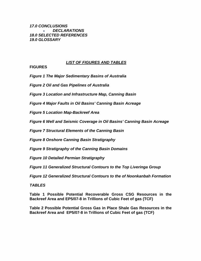
conventional nature. In the case of the latter, it is particularly interested in CSG (=CBM) extraction from the Fitzroy Trough. It is thought that little Permian coal, the postulated source of the CBM will be present on the adjoining Lennard and Laurel Bay Terraces of the basin, east and north of the Blina and associated Oil Fields. The area of the company’s largest permit, EP 5/07-8, which is located overwhelmingly south of the regional Pinnacles Fault Zone and hence in the Fitzroy Trough, is known, from earlier coal exploration drilling, to contain thick intersections of shallow coal over a widespread area. CBM potential is also thought to be present in the south-western portion of the contiguous tenements forming the Backreef Area, namely EP 129 R2 (part thereof), R3 and L6 (part thereof), again located in the Fitzroy Trough. However some of this acreage is located on the Lennard Shelf and Laurel Downs Terrace where the coal is in outcrop or shallowly buried. These locations and the major faults of the Pinnacles Fault System are shown on Figure 4, Major Faults in Oil Basins’ Canning Basin Acreage. Potential for other non-conventional hydrocarbon exploration and development such as shale gas production from tight, source rich shale rich intervals is also present in their under-explored acreage, which is located in the Fitzroy Sub-
basin, the most prospective and the only conventionally productive sub-basin of the Canning Basin.
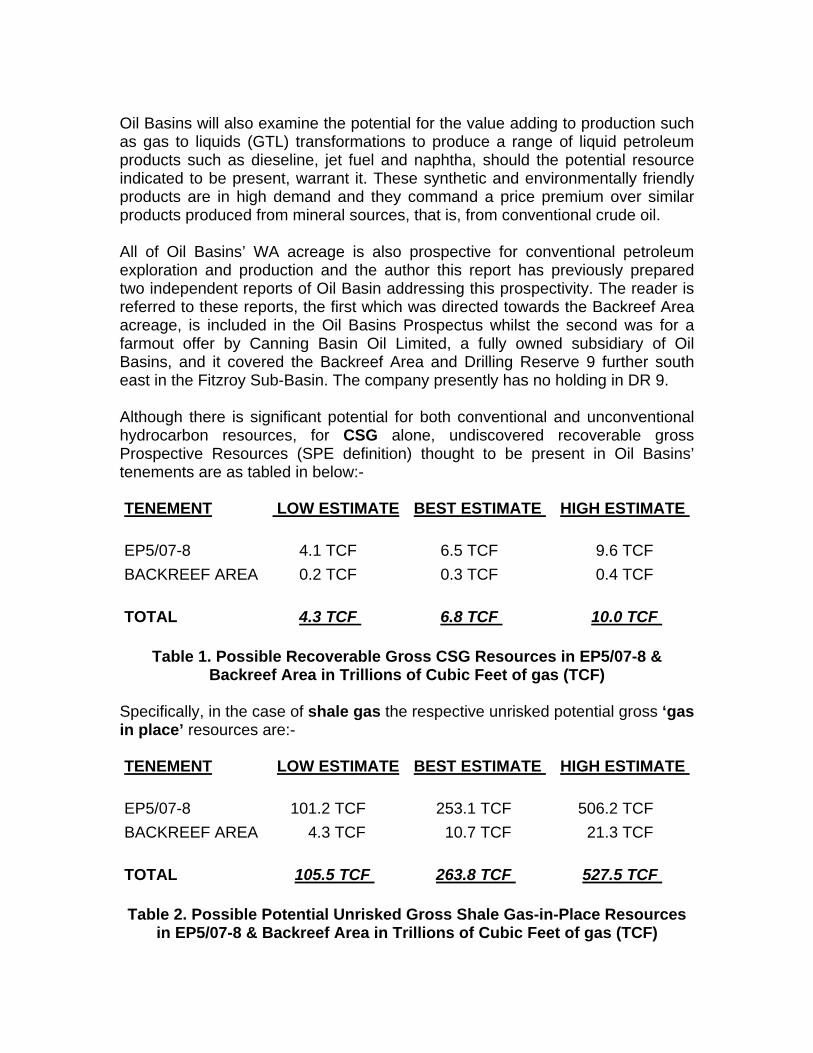
Oil Basins will also examine the potential for the value adding to production such as gas to liquids (GTL) transformations to produce a range of liquid petroleum products such as dieseline, jet fuel and naphtha, should the potential resource indicated to be present, warrant it. These synthetic and environmentally friendly products are in high demand and they command a price premium over similar products produced from mineral sources, that is, from conventional crude oil. All of Oil Basins’ WA acreage is also prospective for conventional petroleum exploration and production and the author this report has previously prepared two independent reports of Oil Basin addressing this prospectivity. The reader is referred to these reports, the first which was directed towards the Backreef Area acreage, is included in the Oil Basins Prospectus whilst the second was for a farmout offer by Canning Basin Oil Limited, a fully owned subsidiary of Oil Basins, and it covered the Backreef Area and Drilling Reserve 9 further south east in the Fitzroy Sub-Basin. The company presently has no holding in DR 9. Although there is significant potential for both conventional and unconventional hydrocarbon resources, for CSG alone, undiscovered recoverable gross Prospective Resources (SPE definition) thought to be present in Oil Basins’ tenements are as tabled in below:-
Table 1. Possible Recoverable Gross CSG Resources in EP5/07-8 &
Backreef Area in Trillions of Cubic Feet of gas (TCF) Specifically, in the case of shale gas the respective unrisked potential gross ‘gas in place’ resources are:-
Table 2. Possible Potential Unrisked Gross Shale Gas-in-Place Resources
in EP5/07-8 & Backreef Area in Trillions of Cubic Feet of gas (TCF)
TENEMENT LOW ESTIMATE BEST ESTIMATE HIGH ESTIMATE
EP5/07-8 4.1 TCF 6.5 TCF 9.6 TCF BACKREEF AREA 0.2 TCF 0.3 TCF 0.4 TCF
TOTAL 4.3 TCF 6.8 TCF 10.0 TCF
TENEMENT LOW ESTIMATE BEST ESTIMATE HIGH ESTIMATE
EP5/07-8 101.2 TCF 253.1 TCF 506.2 TCF BACKREEF AREA 4.3 TCF 10.7 TCF 21.3 TCF
TOTAL 105.5 TCF 263.8 TCF 527.5 TCF
The calorific value of both these resources is anticipated to be relatively high compared to many other gaseous hydrocarbon CSG resources due to the postulated oil prone nature of the coal and shale source rocks, which are thought to contain fresh water and marine, respectively, Type 1 and Type 2 macerals. The coal are thought to be correlatives of the Early Permian Purni coals of the Pedirka Basin of Central Australia and the Early Permian Patchawarra coals of the Cooper Basin also of central Australia. They are thought to have high exinite to vitrinite ratios compared to source rocks in the other Permian basins of eastern Australia. Hence these source rocks are considered to be oil prone. These Permian aged basins, the locations of which are shown on Figure 1, either produce CSG or are being explored for it. Some CSG exploration is being conducted on Permian aged coals in the Perth Basin in the south of WA. Although there is generally a paucity of information, an indicative “factory gate” delivered cost, inclusive of exploration, development and production, is thought to be approximately A$2.00 per thousand cubic feet of gas (MSCFG) for a centrally located GTL plant in the company’s tenements. This price is expected to be higher, due to piping costs, at A$2.20/MSCFG, for a GTL plant located in Derby. These indicative costings are highly volume dependent but would probably support a very large scale GTL plant at oil prices prevailing above US $ 30 per barrel, the current situation. Such volumes, of course, could also be available to service gas markets on the north-western and northern seaboards, subject to prevailing market conditions. Markets for the sale of sales gas do exist in northern and north-western Australia. It is thought that typically a GTL plant will require about 10 thousand standard cubic feet of gas (10 MSCF) to synthesize one barrel of oil. Hence the “high” indicative possible CSG resource anticipated in the Oil Basins’ acreage 10 TCFG, could produce some 1,000 million barrels of liquids. This could conceivably sustain a GTL plant producing 140,000 barrels of liquid GTL products per day for about 19.6 years. It is assumed, reasonably, that each well, after hydraulic fracturing or cavitation would produce on average 2.0 million cubic feet of gas per day (MMCFD), hence some 700 producing wells would be required to feed a GTL plant of this capacity. This is a considerable capital outlay and which would entail a major drilling campaign. If Oil Basins’ program is successful, then with a large scale development drilling program the cost per well would fall markedly due to the reduced mobilization costs. For such a large scale drilling program Oil Basins could further reduce their costs by purchasing a drilling rigs and sub contracting the manning of them to an established drilling contractor Similarly, for a 140,000 bbl/day output plant, the best estimate of 6.8 TCF would sustain a 13.5 year operation and the low case of 4.3 TCF, a 8.5 year plant life.

2.2 Strategy As part of its strategy to obtain commercial hydrocarbon production from the prospective but under-developed Canning Basin, the Company has acquired interests in four very prospective tenements in the onshore sector of the Fitzroy Sub-basin of the Canning Basin of north-western WA. The first is EP 5/07-8 which abuts King Sound in the Derby area. The other is the Backreef Area, of three contiguous tenements, namely EP 129 R2 (part thereof), R3 and L6 (part thereof), which is sited acreage is located over the Pinnacles Fault Zone, in the area of the Blina and associated Oil Fields. The north-eastern portion of the Backreef Area is located on the Laurel Downs Terrace, whilst the south-western portion is located south of the fault system in the Fitzroy Trough. The locations of company’s Canning Basin permits are shown on Figure 3 which also shows the location of the existing oil infrastructure and on Figure 4. In the short term, Oil Basins aims to develop early cash flow via the discovery and production of conventional oil targets, for example, the Backreef Prospect in L6 which could host a very large oil resource (previously estimated at 270 MMbbls – refer to ASX Release dated 18 February 20009. The proposed test well at Backreef would be carefully drilled and monitored for CSG gas indications in the Late Permian Liveringa Group and for shale gas indications in the Late Permian Noonkanbah Formation, Winifred Formation of the Early Permian Grant Group, the Carboniferous aged lower Anderson and Laurel Formations, and the interbedded untested in the Clanmeyer Formation, the primary conventional target zone of the proposed Backreef 1 well. Expected sands, deposited in a backreef environment (within a prognosed ancient submarine channel), of this formation is the primary target of Backreef 1, however the postulated inter-bedded shales, from seismic and inversion studies, are a viable shale gas target in this proposed well. Consideration should also be given to deepening Backreef 1 beyond the proposed total depth to investigate the shale gas potential of the Devonian aged Gogo and Ordovician aged Goldwyer Formations, both are mature, source rich shales of marine genesis which have sourced conventional hydrocarbon accumulations With regard to non-conventional hydrocarbons the company will consider the potential for GTL synthesis for a range of plant sizes from 2,500-10,000-50,000 bbl/day plant options located within the permit EP5/07-8 or more particularly at Derby and fed by gas from either conventional or non-conventional reservoirs. In the company’s Canning Basin acreage the immediate search is for both conventionally and non-conventionally reservoired gas. Oil Basins’ longer term strategy is for a large scale GTL plant located within its acreage. Additional reserve based asset acquisition, for growth, will also be considered by the company.

Whilst to date the Canning Basin is only productive of conventional oil, significant indications of conventional gas are also recorded. In fact gas has been flowed from a drillstem of the Anderson Formation at Point Torment 1 at the rate of 4.3 MMCFD. Significant indications of coals have been encountered in coal exploration programs and in petroleum exploration wells. Very tight, but organic rich shales, as confirmed by laboratory analyses, have also been intersected in petroleum wells. Hence the acreage being explored by the company is prospective for CSG and shale gas exploration. These indications are recorded from sparsely but widespread conventional hydrocarbon exploration wells, within and around EP 5/07-8 and the Backreef Area. To date no effort has been made to search for or to develop non-conventional hydrocarbon accumulations in this area, although similar aged Permian sedimentary section sustains commercial production of non-conventional hydrocarbons in Queensland (QLD) and New South Wales (NSW), namely, CSG, and exploration programs for Permian aged CSG are underway in South Australia (SA). Rocks of a similar age, genesis and lithology are productive of conventional hydrocarbons, both oil and gas in SA and, QLD and gas in NSW. They are also thought to have sourced the conventional hydrocarbons in the Surat and Eromanga Basins of eastern and central Australia. Rocks of an older age, which underlie the Permian section of the Canning Basin sequence, sustain oil and gas production in the Blina and associated oil fields, which are adjacent to Oil Basins’ tenements. Markets for hydrocarbons, either conventionally or non-conventionally reservoired, exist. North-western and northern Australia is “energy short” and faces a looming shortfall in gas supply. Australia is “oil poor” and has a high per capita usage of liquid hydrocarbons, particularly for transport purposes. Oil or other liquid petroleum products such as diesel, jet fuel and naphtha, whether of a natural or synthetic genesis, are readily saleable, particularly with the current high oil prices of approximately US$75/bbl. These prices, whilst they may vary over the short term, are expected to at least prevail in the foreseeable future. In addition, the Varanus Island gas explosion has seriously highlighted the need for alternative and/or standby gas domestic supplies to the large South West WA gas market and regional mining operations. Oil Basins has prepared, or have had other consultants prepare, reports on the conventional hydrocarbon prospectivity of their permits. As such this conventional prospectivity will not be discussed in depth in this report. Oil Basins have plans for the drilling of an oil exploration well with conventional hydrocarbons as the primary targets. This well will also be engineered to evaluate the non-conventional prospectivity, both CSG and shale gas, of the section.

In addition to the chances of discovering and producing conventional hydrocarbons from the Canning Basin, Oil Basins are also drawn to the basin by the significant potential coal resource known to be present. Exploratory coal drilling and sampling has been conducted in the basin, and several open cut mining projects, aimed at the Lightjack Formation, in or near outcrop approximately 30 kms south of EP5/07-87 are planned. Intersections of extensive and widespread coal intervals have been encountered in some oil exploration wells drilled in the basin and ubiquitous coal horizons are identified on seismic data acquired in the basin. The company is investigating little utilized, but known and proven, techniques of producing CSG gas and synthesizing oil from the extensive coal measures and shale gas intervals of the organic rich carbonaceous shales present in their acreage. These processes include:-
• Coal seam gas drainage • Production of shale gas • Gas to liquids synthesis • Fracture stimulation of tight, gas saturated intervals in the coals and
shales. • Horizontal drilling of multiple lateral wells from vertical parent wells.
There is no infrastructure present in the area at this time to transport any produced gaseous hydrocarbons from the area of Oil Basins’ permits, the magnitude of the potential hydrocarbon resource and expected production rates could sustain the construction of high pressure gas pipelines or dual phase gas and liquids pipelines to new facilities. In the short term, to ensure a speedy cash flow, any liquids produced, from either conventional or small scale synthesis development of non-conventional sources, could be stored at the existing Erskine Terminal and then trucked to the existing storage and loading facility at Broome, for export or domestic consumption. In recent years the small volumes of oil produced in the Blina Oil Field have been trucked directly to the Kwinana Refinery, south of Perth. The existing adjacent pipeline infrastructure, both oil and gas, is shown on Figures 2 and 3. Large volumes of gas, if discovered and produced, could be sold directly, subject to prevailing market conditions. This would involve the construction of a new high pressure gas pipeline to existing power generating facilities in the West Kimberley at Broome and Derby and in the East Kimberley at Wyndham and Kununurra and perhaps the Argyle Creek diamond mine and users in the Northern Territory. These are the obvious gas markets for a Canning Basin discovery. Given the national shortage of gas, possible interconnections could be made to the existing WA pipeline grid or the Alice Springs to Darwin pipeline, which has potential for interconnection with the Cooper Basin pipelines which in turn have
access to markets in all the southern and eastern states. An interconnection to the Cooper Basin gas facilities would result in the possibility of subsequent transmission into the national gas pipeline grid which interconnects South Australia with Queensland, New South Wales, the Australian Capital Territory, Victoria and Tasmania. Any gas produced could also be piped to Derby or even the proposed Liquefied Natural Gas (LNG) plant at nearby James Price Point some 170 miles west of the centre of EP 5/07-8. This gas could be transported by a potential pipeline to connect with the Alice Springs to Darwin pipeline for local sale in the “Top End “or for compression and export. These pipelines are shown in Figure 2. Markets, either national or export, appear to exist for any hydrocarbons produced from the Canning Basin acreage, whatever their genesis. 2.3 Prospectivity Oil Basins commissioned a study of the coal potential of their Canning Basin tenements. The subsequent report, “Desktop Study Coal Potential of 5/07-8 and Backreef Area Canning Basin”, by Westby Consulting of East Perth WA is a thorough compilation of all the coal exploration conducted in the Fitzroy and Gregory Sub-basins. The results of that study, which have been confirmed by the author of this report, have established that the onshore Canning Basin fulfils all the requirements for the hosting of CSG hydrocarbon accumulations. Earlier studies and empirical results have established the conventional hydrocarbon prospectivity of the area. Recent work has also established that the tenements hold high potential for shale gas accumulations. Several operators have begun the search for shale gas. Recently a large Japanese trading company has entered the search for both conventional and non-conventional hydrocarbons in the Canning Basin. The will fund an extensive exploration program, possibly to the tune of A$150,000,000. The requirements necessary for the presence of hydrocarbon accumulations are, namely:- For conventional Hydrocarbons
• The presence of rich, mature, source rocks • The presence of reservoir quality rocks and carrier beds • The presence of sealing units • The presence of traps, both of a structural and stratigraphic
genesis, and • The existence of traps prior to the bulk migration of
hydrocarbons

For non-conventional hydrocarbons:-
• The presence of thick and widespread coal beds for methane adsorption, at appropriate depths
• The Mature organic rich shales for tight or shale gas entrapment The source rocks mentioned above could source either conventional or non-conventional hydrocarbons. They could have generated oil and or wet gas, and with deeper burial, dry gas, as they appear to be rich in the liquids generating macerals. The coal beds, which appear to have been uplifted, may still contain adsorbed methane and the organic rich shales may host tight or shale gas. It is the author’s view that, to the present, the lack of commercial exploration success and production from the area of Oil Basins’ permits has been due to the lack of seismic coverage and the sparsity of drilling. In some areas it is due to the lack of drilling, as well as the perceived distance from existing facilities. And in the case of gas, the lack of appreciable contemporary local markets traditionally has inhibited exploration. The market dynamics of north-western Australia have changed markedly in recent years, for the better. Another factor is that until very recently the main exploration target in the basin was the Carboniferous and Devonian carbonates. These units have been disappointing due to the lack of reservoir development, either primary or secondary, whether dolomitization or dissolution. Oil Basins’ proposed targets are clastics in the case of conventional exploration and in its non-conventional exploration effort, coals for CSG and tight organic rich shales of marine origin for shale gas.
The oil price slump in 1986, which was followed by the stock market crash of October 1987, which made fundraising for juniors engaged in exploration very difficult, inhibited exploration or many years. Hence exploration levels dropped markedly. Finally, the lack of infrastructure in the general area, other than the oil terminal at Erskine and the oil loading and storage facility at Broome has inhibited gas exploration, whether conventional or non-conventional, markedly. Given the above conditions particularly the low oil prices, up until fairly recently, meant that the monetisation of gas in particular (via GTL) but also oil have been difficult and a barrier to frontier exploration. However, the potential size of Oil Basins’ intended targets, and the proposed associated exploration and development and ancillary projects should counteract these previous constraints, if the exploration is successful. The intention to produce synthetic crude oil and then refined liquid products from gas is particularly innovative and may ensure the development of a large, known, but un-utilized, coal, and possibly methane and shale resource. It also must be remembered that globally, oil consumption is increasing, with Western countries

importing increasing volumes of more oil. And Australia is an oil poor nation with a large per capita usage of liquid hydrocarbons as transport fuels. 3.0 TENEMENTS The company holds two hydrocarbon exploration tenements in the Canning Basin of WA. These are the informally named Backreef Area and EP 5/07-8. 3.1 Backreef Area Under the terms of Settlement of its Dispute with Arc Energy as announced to the ASX on 31 October 2008, Oil Basins has the right but not the obligation to farm into the Backreef Area, which actually is composed of three contiguous tenements, namely, EP 129P Remainder (R)2 (part), R3 and Production Licence (L) 6 (part) as shown on Figure 5. This acreage is located in the Fitzroy Sub-basin of the Canning Basin in the vicinity of the Blina and associated oil fields and it straddles the Pinnacles Fault System so that the south-western portion of the area is in the Fitzroy Trough whilst the north-eastern portion is located on the fringing Laurel Downs Terrace. The company will earn hold 90% of the Backreef area upon the funding and drilling of the proposed Backreef 1 well to at least 1,500m by 31 October 2010. Backreef Oil Pty Limited will then hold the remaining 10%. Several overriding royalty interests (ORRIs) are held by other companies over the Backreef Area, or part of it. These are listed below along with a back in right held by Buru Energy Limited (Buru) over the Backreef Area:-
• A 2% ORRI is held by Columbus Energy Ltd over the entire Backreef Area • A 3% ORRI is held by European Gas Limited over the entire Backreef
Area • A 1% ORRI is held by Budside Pty Ltd over EP 129P • Buru Energy Limited holds a back-in right to earn 30% of the Backreef
Area by paying Oil Basins 90% of the cost of Backreef 1 well. This right must be exercised within 90 days of the completion of the Backreef 1 well.
• Under the terms of the Settlement Agreement, a second well must be drilled in the Backreef Area within 18 months of drilling the Backreef Prospect to finalise the farmin.
The Backreef Area consists of all or part of 7 graticular blocks, each block of is 1minute of latitude by 1 minute of longitude and extending, on average, over an area of 75 km2. Five of these blocks are located on the Derby 1:1,000,000 Block Identification Sheet and 2 are on the Lennard River 1:1,000,000 Sheet. The Backreef Area extends over approximately 354 km2.
3.2 EP 5/07-8 Oil Basins and Backreef were awarded EP 5/07-8 in equal parts on 11th December 2007. This tenement is also located in the Fitzroy Sub-basin, the most prospective and productive sub-basin of the Canning Basin of WA. It covers some 62 graticular blocks on the Broome 1: 1,000,000 sheet and extends over an area of 5062 km2. This tenement which contains Derby in its north-western section is centred on the north-western portion of the onshore Fitzroy Trough. It trends form the northwest to the southeast, parallel to the basin’s main structural trends. It extends out into the WA State territorial waters of King Sound and further offshore The permit has recently been offered to Oil Basins and Backreef and the permit term of 6 years duration will commence upon the successful negotiation of a Native Title Agreement with the Kimberly Land Council, which is yet to be completed. The agreed work program and associated estimated expenditure for the tenement is:- Year Agreed work Program Estimated Expenditure 1 500 line kms of seismic $ 2,700,000 2 2 wells $ 3,000,000 3 2 wells $ 3,000,000 4 200 line kms of seismic $ 1,100,000 5 1 well $ 1,500,000 6 1 well $ 1,500,000 The proposed activity can be altered, after discussion with the WA Department of Mines and Petroleum, however the expenditure figure is expected to be met. The permit awarding has an associated 50% compulsory relinquishment condition associated with it. Hence it can be renewed for another 5 year term after which, unless a discovery has been made it will be fully surrendered. A new application and bid can be made when the tenement is re-advertised in the WA Government Gazette. This granting of the permit also includes the rights to any coal bed methane as well as conventionally reservoired gaseous and liquid hydrocarbons. If any commercial discovery is made, the operating company, and any Joint Venture partners are automatically granted a 21 year Production License over the discovered field. This Production Licence is renewable for the life of the field. In the event of a non-commercial discovery the company can apply for a Retention Lease over the field. This Lease is of 6 years duration and is renewable until the field is deemed to be commercial. The associated Pipeline Licence is usually automatically granted upon submission of an application.

The initial exploration targets were conventionally reservoired hydrocarbons, in this prospective, but under-explored, basin. However this permit is also prospective for unconventional hydrocarbon exploration, due to the presence of extensive coal measures. Late and Early Permian coals of other basins in eastern and central Australia are known to be ‘‘gassy” and productive of coal bed methane or CSG. These units the acknowledged source of the extensive conventional oil and gas accumulations in the Mesozoic Eromanga and Surat Basins, which overlie those Permian source rocks of the Cooper and Bowen Basins respectively. Recent work has identified shale gas potential in organic rich shales, some of these units are acknowledged as the source of conventional hydrocarbon discoveries in the Fitzroy Sub-basin. Shale gas, whilst quite novel is actually the oldest form of hydrocarbon production, with wells at Fredonia in New York State in the USA producing shale gas from the Devonian aged Fredonia Shale as early as 1821, well before Edwin Drake’s first oil well at Titusville Pennsylvania in the same basin. In this case the gas which is generated in the shale is adsorbed to the shale and cannot escape and migrate to conventional reservoirs which have porosity to store the gas and permeability to allow for the transmission of gas through the rock to the area of reduced pressure around the well bore. As a consequence the company has decided to explore for both conventional and non-conventional resources simultaneously. It is expected that an oil prospect will be the initial target. This report will only address non-conventional hydrocarbons. 4.0 METHODOLOGY The basis of this report was an open file study of much of the data available on the onshore Canning Basin for both petroleum and coal exploration. An independent report prepared by Westby Consulting Services of Perth WA, for Oil Basins, was heavily utilized for information on the extent of coal seams, coal properties, coal thickness and potential coal volumes, gas saturation and other CBM properties and it was invaluable. In house reports provided by Oil Basins were also referred to, as well press as releases by Rey Resources Limited and Red Sky Energy Limited, Buru, New Standard Exploration, Cullen Resources Limited, Blue Energy Limited Beach Petroleum Limited, Bow Energy Limited, Liberty Resources Limited and Emerald Oil and Gas N.L. amongst others. Many papers on shale gas exploration in the USA were also referred to as were many articles on shale gas on the internet. As were annual reports, on coal exploration activities, to the WA Department of Mines & Petroleum by Rio Tinto Exploration Ltd, Conzinc Rio Tinto Australia Limited and Thiess Brothers Pty Ltd. General reports on coal exploration were also referred to as well as a

comprehensive report by Halliburton of Duncan, Oklahoma on CBM exploration and development procedures. Publically available articles on the Internet were also referred to, as were reports, by independent experts, on GTL activities and procedures. The reader is referred to these reports. Knowledge in the possession of the author of coal seam gas drainage exploration and production in NSW and QLD and CSG exploration in SA was also included as was his knowledge of conventional exploration in NSW, QLD, NT, WA and SA. Knowledge of possible CSG and GTL projects in Central Australia is also incorporated in this report. Publications on coal bed methane exploration, development and production were also referred to as were similar reports on shale gas. Other reports prepared by the author on CSG, tight gas and GTL were also referred to. 5.0 THE COMPANY As indicated by the name, Oil Basins is a company which was initially focused on the conventional hydrocarbon potential of Australia, particularly oil, in the prolific offshore sector of the Gippsland Basin of Victoria. Oil Basins also acquired an acreage holding in the Backreef Area of the Fitzroy Sub-basin of the onshore sector of the Canning Basin of WA. That acreage is adjacent to the Blina and associated oil fields. The company later acquired an interest in Retention Licence (R) 5, which contains the yet to be developed Cyrano heavy oil discovery. This tenement is located on the Peedamullah Shelf of the hydrocarbon productive Northern Carnarvon Basin in shallow nearshore WA territorial waters. The company’s most recent acreage acquisition has been in another onshore Fitzroy Sub-basin block, EP 5/07-8 located around Derby in an area of several oil shows and a well, Port Torment 1, which flowed gas on drillstem test at a normally commercial rate. It is a relatively new public company with a significant, but varied acreage portfolio in productive basins. The company’s acreage holds substantial potential for conventional hydrocarbon discoveries. The company’s appreciable acreage holdings in the Fitzroy Sub-basin of the Canning Basin also hold significant potential for non-conventional hydrocarbon discoveries, particularly CSG extraction and shale gas. Should a large enough resource be proven up then potential may exist for a GTL project, the way to extract the greatest monetary return on a non-conventional resource in the remote area of northwest Australia. As this report is directed specifically towards non-conventional hydrocarbon exploration, the company’s Gippsland and Carnarvon Basin acreage will not be discussed. Currently Oil Basins holds equity in over 5416 km2 of ground in granted permits and a Production License in the basin hence it has a significant acreage position.
It has objectives to produce both conventional and non-conventional hydrocarbons from this prospective, productive but under-explored basin. The company has innovative plans to develop and produce hydrocarbons from a potentially large, long known but un-utilized coal resource and from organic rich but tight shales. Given the company’s extensive acreage holdings, if their programs are successful, they will control much of onshore north-western Australia’s future hydrocarbon production, particularly in the Fitzroy Sub-basin. The company has innovative and far-sighted plans to develop a potentially huge, non-conventional hydrocarbon resource in a time of energy shortage, in general, and in north-western Australia, in particular. Their plans for the synthesis of liquid hydrocarbons from gas are particularly enterprising, as liquid hydrocarbons command a premium over the sale of gas, and the nation and the Western world is in short supply of oil. Zero to low sulphur ultra-clean dieseline, a potential product of the Company’s GTL strategy, is expected to command an increasing premium over conventional mineral oil diesel as it is progressively and more extensively being used for blending to meet environmental regulations. Diesel powered motor vehicles have increased their market share in recent years and this trend is likely to continue. Rural Australia, especially northern Australia, is a large per capita user of dieseline. 6.0 PREVIOUS EXPLORATION The acreage held by Oil Basins Central in the north-western sector of the Fitzroy Sub-basin is relatively unexplored for conventional hydrocarbons, in an exhaustive, systematic and definitive manner. It has had no non-conventional hydrocarbon exploration conducted at all. The first recorded indications of oil in Western Australia were encountered when Walter Oakes, a returned serviceman, with knowledge gained from American troops in France, discovered an oil seep, after a deliberate search, at the junction of the Ord and Negri Rivers in the Kimberley in 1919. This area is now known as the Ord Basin which overlies the gas productive Bonaparte Basin. A company, Durack Oakes Oil Company, associated with the famous pioneering pastoralist family of the Kimberley, was subsequently formed to drill for, and produce this oil. That company drilled an unsuccessful shallow well near this seep in 1924. Soon afterwards a water well driller, Harry Price, encountered traces of oil in a water bore in the valley of the Fitzroy River. These indications of hydrocarbons, oil particularly, were the stimuli of a long, and for a long time, fruitless search for hydrocarbons in the state of Western Australia (WA). The first exploration company to scientifically explore in the Canning Basin was the Freney Kimberley Oil Company Limited, formed to investigate Harry Price’s
accidental encountering of oil. The company drilled several wells in the Canning Basin during the next 30 years. Several reconstructions of the company, which struggled for funds, occurred and its last successor, Associated Freney Oil Company N. L., part of the famous Associated Group which successfully explored the Roma Shelf of Queensland, encountered indications of oil in its last well, Sisters-1, drilled in 1956. Ironically this well is close to the area of the first oil discoveries on the Lennard Shelf. Beginning in the early 1950’s West Australian Petroleum Pty Ltd (WAPET), an affiliate of the large American major, Chevron, conducted an exhaustive search for oil in WA. They explored in the onshore and near-shore sectors of most of the sedimentary basins of the state, including what is now known as the Canning Basin. The company found, in 1953, non-commercial oil in the onshore sector of the Carnarvon Basin at Rough Range-1, the company’s first well, in the Exmouth area. The locations of the sedimentary basins of WA are shown in Figure 1.
After approximately a decade of further exploration WAPET finally had commercial success and discovered oil and gas, in commercial amounts, in the Perth Basin, in the state’s south: this was followed by the discovery of the giant Barrow Island Field in the Carnarvon Basin, along with the discovery of many smaller but still commercial fields, in both the onshore and near offshore sectors of that basin. During this time WAPET continued to search in the Canning Basin and did encounter non-commercial traces of oil in the Meda-1 well. Other large gas discoveries were made by other companies further north in the Bonaparte Basin. Commercial oil was later found in that basin. Other operators then found gas and indications of oil in the offshore Browse Basin, immediately north of the Canning Basin, commercial gas discoveries have since been made in the Browse Basin. Hence the Canning Basin was surrounded by basins with hydrocarbon production or discovered reserves. By 1974 WAPET had surrendered most of their acreage in the Canning Basin and many smaller operators began to explore the Canning Basin. Many of these companies were from Canada and they were drawn to the area by the presence of Devonian reefs, the staple target in oil-productive Alberta and British Columbia. Commercial success was finally achieved in the Canning Basin in 1981 when the Canadian company Home Oil Limited (Home) discovered oil in commercial quantities in the Blina-1 well. Ironically the Blina Prospect was very close to the Erskine Prospect mapped, but never drilled, by WAPET. The following year Home found another small, but commercial, oil field with the Sundown-1 well, nearby. Later the similar West Terrace Oil Field was discovered in the same general area. Other small fields were subsequently discovered. There have been several later waves of exploration in the basin, none of which have been conclusive. Exploration activity has fluctuated with the oil price. The

Canning Basin remains a prospective but under-explored frontier oil province. To date exploration has been directed towards conventional hydrocarbons in reefal traps and carbonate reservoirs. Oil Basins proposed conventional exploration is directed towards stratigraphic traps with presumed clastic reservoirs. The identified conventional Backreef Prospect is a new, novel and innovative play directed towards undrilled clastic (sandstone) section in the Kimberley Downs Embayment, in a back reef environment. Such plays are productive in other mixed carbonate/clastic basins. The target, section is believed to be sandstone eroded sub-aerially, from shelf deposits, however it may be a calcareous or even oolitic sandstone eroded from an exposed reef. This proposed well will also test for CSG and shale gas potential within the Backreef Area. The central sector of the Fitzroy Sub-basin, around Oil Basin’s acreage, is the most heavily explored portion of the basin and sub-basin respectively, particularly on the Lennard Shelf and Laurel Downs Terrace in the area around the Blina and associated discoveries. In the Fitzroy Trough, in the area of EP 5/07-8, EP 129 and L6, the earliest geophysical surveying was conducted by the Bureau of Mineral Resources, Geology and Geophysics (BMR), now known as Geoscience Australia, when in 1954 they conducted an extensive aeromagnetic survey. This work was done as part of their famous Northern Australia Mapping Project. This was followed by their regional Fitzroy and Canning Basin Gravity Surveys. Other later gravity surveys were undertaken by WAPET. In 1963 WAPET undertook regional reflection seismic surveying. This was followed between 1963 and 1972 by other seismic surveys conducted for both WAPET and Conoco. In the early 1980’s many companies with Canadian connections recorded extensive seismic programs in the area of the Laurel Downs Terrace, around Blina. 6.1 Backreef Area The Canadian company, Home Oil (Home), found oil in a Devonian and a Carboniferous reservoir in 1981 in the Blina 1 well, located on the Laurel Bay Terrace. It was the first commercial oil discovery in the basin. Other oil discoveries, by Home, in the area followed at Sundown 1 in 1982, West Terrace 1 in 1985, Lloyd 1 in 1987 and Boundary 1 by Petroleum Securities Limited (Petsec) in 1990. Many relatively shallow wells, which were targeted at the Devonian or Carboniferous carbonates, were also drilled in the area adjacent to the Backreef Area. All of these wells failed to discover commercial hydrocarbons although oil and gas shows were recorded from some of them. Since the divestment by Home Oil in the mid-1990’s these assets have had a variety of owners and farmin partners including Kimberley Oil, European Gas and Golden

Dynasty with sporadic drilling and appraisal activity (mainly in L6 and L8). The majority of exploration in the Blina area since 2007 has been conducted by Arc Energy, and following the Merger Scheme of Arrangement with AWE Limited, now Buru Energy Limited who recently drilled a dry hole at Fairwell 1 in nearby L8. It has been aimed primarily at Devonian and Carboniferous targets and has proved to be unsuccessful. Only two wells, Lukins 1 and Harold 1, both drilled in 1995 are located within the Backreef Area. Neither well was successful, they too were directed towards Devonian and/or Carboniferous carbonate targets on the Laurel Downs Terrace. 6.2 EP 5/07-8 The early exploration in EP 5/07-8 was conducted by the companies and authority, previously mentioned, as part of the in the same regional exploration programs. In the early 1980s several companies including Esso Australia Limited
(Esso) and Bridge Oil Limited (Bridge) Joint Venture and later Bridge recorded an appreciable amount of regional seismic data in the area around Derby and King Sound, in and around EP 5/07-8, however little of this seismic is located in the central portion of the permit. Most of the seismic coverage is located around the tenement boundaries, as shown on Figure 6, a well and seismic coverage map of Oil Basins’ Canning Basin acreage.

The Joint Venture and Bridge drilled several wells. Only three wells, Puratte 1 drilled in 1979 by Esso, Booran 1 also drilled by Esso in 1982 and East Yeeda 1 drilled by Bridge in 1985 are located within EP 5/07-8. All are sited within the Fitzroy Trough. Esso drilled the Kora 1 just north of the permit in 1982 and then Jum Jum 1 to the west of the tenement in 1985 and West Kora 1 adjacent to Kora 1, north of the permit in the same year. Kora 1 and West Kora 1 are located on the shallower Lennard Shelf which abuts the northern flank of the Fitzroy Trough. In 1992 Anzoil drilled the Point Torment 1 well, which flowed gas on drillstem test from the Anderson Formation at the rate of 4.3 MMCFD. The formation appeared to be damaged and the well was deepened by Stirling Resources in 1994 without commercializing the discovery. In 1987 Sydney Oil Company drilled the Padilpa 1 well to the north of the permit. Capital Energy drilled the Millard 1 well to the north of the tenement in 1997. Later wells drilled by Arc Energy/Buru as follow up to the Point Torment 1 discovery, Stokes Bay 1 and Valentine 1, were
drilled. Hydrocarbon indications were encountered, in the Nullara Limestone in Stokes Bay 1 and in the Anderson Formation in Valentine 1; however the discovery at Point Torment 1 is yet to be declared commercial. The pioneer explorer WAPET had previously drilled two frontier wells, the shallow Fraser River (Stuctural) 1 in 1955 and the deeper Fraser River 1 in 1956 to the southwest of EP 5/07-8.
Little conventional exploration has occurred in recent years in the area covered by the company’s Canning Basin acreage. And no non-conventional hydrocarbon exploration has ever been undertaken in this area.
Recent work has upgraded the petroleum potential, particularly non-conventional, of the area held by Oil Basins markedly. This work has confirmed the presence of mature source rocks, with oil generative potential, in the area of question, the presence of traps, and confirmed the accepted belief in the presence of good clastic reservoir units. Seals are known to be present within the blocks. No work, other than Oil Basins’, has been done on the non-conventional prospectivity of the tenements. This prospectivity appears to be high. 7.0 GEOLOGY
The Canning Basin is a large intra-cratonic sedimentary basin located in north-western Australia. It is comprised of four major sub-basins as shown in Figure 7. Oil Basin’s acreage in WA is restricted to the most north-westerly of these, the Fitzroy Sub-basin (=Trough) and on the adjacent Pender Terrace and Lennard Shelf in the case of EP5/07-8 and the Lennard Shelf and Laurel Downs Terrace in the case of the Backreef Area. Oil production has been obtained from several intervals and several wells in the Sub-basin, primarily the Yellow Drum Formation and Nullara Limestone at the Blina Oil Field. Gas has also been encountered in several intervals in several wells in this sparsely explored area. Gas was flowed on drillstem test at the rate of 4.3 MMCFD from the Anderson Formation in the Point Torment 1 well, which is located to the northwest of EP 5/07-8. Minor recoveries of, and indications of, hydrocarbons have been made in several of the few wells drilled into this prospective but under-explored and remotely located basin. Many of these wells seem to be inappropriately sited to definitively evaluate traps, in particular, and the basin in general.
The area encompassed by Oil Basin’s permits contains sedimentary sequences, which range in age from the Ordovician to Cretaceous. Historically most exploration has been aimed at the Devonian and Carboniferous intervals in general and the calcareous shelfal limestones in particular. In general these targets have lacked reservoir development. Hydrocarbon indications have been encountered from the Ordovician Nita Formation up to the Permian aged Poole Sandstone. The Canning Basin section is contiguous with the oil and gas productive Amadeus Basin across a shallow basement ridge near the WA/NT/SA border, southwest of Alice Spring. The Paleozoic Amadeus Basin produces oil and gas from the Ordovician section in the Palm Valley and Mereenie Fields, respectively.

7.1 Regional Geology Oil Basin’s Canning Basin block, EP 5/07-8 acreage is located in northern WA, in and around the township of Derby abutting the south side of King Sound, as shown in Figures 3&4. The other Canning Basin block, the Backreef Area is located to the southeast of EP 5/07-8 and is adjacent to the Blina and associated oil fields, as shown on the same Figures and at a larger scale on Figure 5. The Canning Basin of Western Australia covers an area of 640,000 km2 of which 530,000 km2, or 83 percent, is located onshore. Oil Basins holds some 5416 km2, all of which is located in the most prospective sub-basin, the Fitzroy Sub-basin and on the fringing Pender and Laurel Downs Terraces and Lennard Shelf to the north. The Canning Basin sequence in the Fitzroy Sub-basin contains a mixed carbonate and clastic sedimentary sequence at least 15 kilometres thick They range in age from Ordovician to Cretaceous. The oldest being the Paleozoic sediments of the Nambeet Formation which overlies Precambrian economic basement. The traditional exploration targets in the basin have been intervals of Devonian and Carboniferous age often carbonates on the shelfal areas fringing the down thrown depocentres. The Permian and Triassic and limited Jurassic intervals are of a more clastic composition.
For CSG exploration the main targets are coal seams of the Permian Lightjack Formation of the Liveringa Group. Other minor coal is present in the underlying Permian Noonkanbah Formation and the overlying Jurassic aged Wallal Sandstone. The main target for shale gas exploration are the interbedded shales of the Noonkanbah Formation, other secondary targets are the shales of the Winifred Formation of the Permian aged Grant Group, the lower Anderson Formation of Carboniferous age, the Carboniferous Laurel Formation the Devonian aged Gogo Formation and unnamed and unintersected but interbedded shales of the Clanmeyer equivalent in the Kimberly Downs Embayment in the Backreef Area. This section is recognized on reprocessed seismic sections and on acoustic impedance plots. The rarely penetrated deeper Ordovician Goldwyer Formation is also a possible target. 7.2 Tectonic Setting The Canning Basin sequence had its genesis in the Early Paleozoic time when sedimentation began into an intra-cratonic sag between the Kimberly and Pilbara Precambrian Basement Blocks, located to the north and south respectively. Sedimentation in the Canning Basin was controlled and constrained by these basement blocks of metamorphic and igneous composition.

.


The basin is composed of two northwest trending troughs which are separated by a central basinal platform. These three major tectonics elements are all bisected by a northeast trend forming six structural sub-domains. The northern trough is

Sub-

divided into the Fitzroy Sub-basin in the northwest and the Gregory Sub-basin in the southeast. The central basin high is divided into the Broome Platform in the northwest and the Crossland Platform in the southeast. Finally the southern trough is divided into the Willara Sub-basin in the northwest and the Kidson Basin in the southeast. These structural subdivisions are shown on Figure 7 along with a schematic cross-section. Several significant cyclic tectonic events affected sedimentation in the basin, the first was extension and rapid subsidence in the Early Ordovician. This was followed by compression, uplift and erosion in the Early Devonian. In the Middle Devonian another episode of extension and subsidence occurred. A transpressive event occurred from Middle Carboniferous time until the Permian which also resulted in some uplift and erosion. Further subsidence and minor uplift then occurred in Early Permian time. The final major tectonic event was the Late Triassic Fitzroy Event of dextral uplift and subsequent erosion. Structuring was much less pronounced in the southern portion of the basin than the north and deposition was much thinner there also. It is thought that up to 15 km of section was deposited in the Fitzroy and Gregory Sub-basins whereas only 4 km was deposited in the Willara and Kidson Sub-basins.
7.3 Stratigraphy The stratigraphic sequences of the Fitzroy and Gregory Sub-basins, the basin’s northern sub-basins are similar but some differences do occur. A detailed stratigraphic determination for the former sub-basin, the only one of immediate interest to Oil Basins, as determined by Doral Resources, a former operator in the basin, is essentially transcribed below. The southern sub-basins contain a much thinner section and are not discussed in this report. The stratigraphic description of the Fitzroy Sub-basin has been taken from the deep Cycas 1 well, as it penetrated a much more complete section than did Blina 1, the deepest well in the vicinity of the Backreef Area. Most wells in the region adjacent to the Backreef Area were terminated high in the section, within the producing interval, and did not intersect a representative section of the sub-basin. The four frontier wells drilled within EP 5/07-8 are deeper tests and penetrated a fuller section. Puratte 1 reached total depth of -3517m subsea in the Devonian Virgin Hills Formation, East Yeeda 1 bottomed at -3202.7m in the Devonian Yellow Drum Formation. Booran 1 reached total depth of -2228.6 m in the Carboniferous Anderson Formation whereas Wonjil 1 reached total depth of approximately 350m in the basal coal seam of the Lightjack Formation of the Liveringa Group. A generalized stratigraphic column for the Canning Basin is included as Figure 8. This table also has annotated on it the major tectonic events in the basin’s evolution. Also shown on this detailed stratigraphic column are all the known

conventional reservoir, sealing and source intervals as well the units from which major hydrocarbon recoveries have been made. The Permian intervals contain coal seams which are both the potential source and reservoir units for CSG storage, minor coal is also present in the Jurassic Wallal Sandstone. The Liveringa Group contains the major CSG target the basal coals of the Lightjack Formation. A major shale gas target, the Noonkanbah Formation conformably underlies the Liveringa Group. Similar shale gas targets are believed to be present in the Grant Group, Laurel, lower Anderson, Gogo and Goldwyer Formations. These units will also act as source and reservoir intervals for possible shale gas accumulations. A more sub-basin specific stratigraphic column, related to mineral exploration is included as Figure 9 and a detailed Permian Stratigraphic Table is included as Figure 10. The stratigraphic sequence contained in the Fitzroy Sub-basin extends from the Ordovician to the Cretaceous, and is discussed below. The stratigraphic extrapolation for the proposed Backreef 1 well, in the central Fitzroy Sub-basin is taken from wells in the Blina Oil Field area. The potential shale gas target horizons are constrained by sub-surface intersections in a more widespread set of wells, stretching from Puratte 1 northwest of Derby to Crimson Lake 1 which is located to the southeast of the Blina area. Economic Basement Economic basement to the Fitzroy Sub-basin are Pre-Cambrian igneous and metamorphic rocks. Ordovician Sediments of this age are the most deeply buried sedimentary rocks in the Fitzroy Sub-basin. The-section commences with a marine transgressive sandstone, the Nambeet Formation, which unconformably overlies Precambrian Basement. These sands are conformably overlain by interbedded shales and limestones of the Willara Formation and marine, black euxenic shales of the Goldwyer Formation, a potential candidate for shale gas production. These in turn are overlain by shallow marine to intertidal limestones of the Nita Formation. Late Ordovician - Early Silurian Although not penetrated in the Fitzroy Sub-basin, the evapouritic section of the Carribuddy Group is inferred to be present, based on the presence of salt diapirs. The Carribuddy Group, which had a depositional setting of sabkha, supratidal and marine environments, conformably overlies the Nita Formation.

The Carribuddy Group is conformably overlain by the marine and aeolian deposits of the Worral Formation. Middle Devonian - Lower Carboniferous Poulton Formation, Gogo Formation, Pillara Group, Clanmeyer Formation (=Siltstone), Nullara and Fairfield Groups. This sequence of units begins with the Poulton Formation, at the base, which unconformably overlies the Silurian Worral Formation. These limestone, sandstone, and shale units were deposited under shallow marine conditions and are part of the reef complexes which occurred during this time. The ages of the units range from the Givetian (Devonian) and the Tournaisian (Carboniferous). None of these units were recorded from Cycas 1 well in the southeast of the Fitzroy Trough, which was abandoned at a depth of 3019 metres in the Visean. However these units are known to be present in the vicinity of the Blina wells and were intersected in the Puratte1 and Kora 1 wells in the northwest of the Fitzroy Sub-basin. The Gogo Formation has been established to be the major source interval for the Blina and associated oil fields and is a potential sourcing unit for the Backreef Prospect, a combined conventional and non-conventional test. It is a very likely candidate for shale gas accumulations. The conventional target of the proposed Backreef 1 well is undrilled interpreted eroded and re-deposited clastic section within the Clanmeyer Formation. This target is, due to its interbedded seismic signature, also a postulated shale gas target. The organic rich but tight shales of the Laurel Formation of the Fairfield Group are considered by several Canning Basin operators to be potential shale gas producing intervals. The Anderson Formation consists of carbonate and clastic sediments that reflect the regressive transition from shallow marine to continental conditions. These were deposited within the rapidly sinking Fitzroy Trough and along the Lennard Shelf and can be further sub-divided into four distinct units, namely:- Unit D: This unit was penetrated in the southeast of the sub-basin in the Cycas 1 well between 2813-3019 metres and it consists dominantly of red brown shale, gradational to siltstone, which is moderately hard, blocky to sub-fissile, in part micaceous and slightly sandy. There are also minor interbeds of light grey, clear and red brown sandstone that is fine to very coarse grained, angular, poorly sorted, hard, mostly as strongly cemented aggregates with kaolin and red brown silt matrix. Occasional thin limestone interbeds occur that are light grey to light brown, microcrystalline, hard and in part dolomitic. Unit D unconformably overlies the Fairfield Group and is Tournasian-Visean in age.

Unit C: This unit was present in Cycas 1 (2377 - 2813 metres) and consists of interbeds of sandstone, siltstone, and shale with occasional thin beds of limestone. The sandstone varies from clear to light grey in colour, becoming red brown below 2765m. It is fine to medium grained, moderate to well sorted, sub-angular to sub-rounded, with a weak calcareous cement, becoming more siliceous with depth. The firm to moderately hard, subfissile to fissile interbeds of shale and siltstone are dark grey, grey, red brown and light green, while the limestone is light brown, microcrystalline and moderately hard. Unit C conformably overlies Unit D and is Visean in age. The organic rich intervals of this unit, Unit C, are considered to be a potential shale gas targets. Unit B: This unit was also penetrated between 2220 and 2377 metres in Cycas 1. The light grey sandstones range from fine to medium grained, poor to well sorted with a moderate siliceous cement and up to 5% kaolin matrix. These are interbedded with dark grey, red brown and light green shale and siltstone, as well as light grey to brown, microcrystalline, soft to moderately hard limestone that registered traces of pyrite. A white soft anhydrite bed at 2350 metres is 3.5 metres thick. Unit B conformably overlies Unit C and is also Visean in age. Unit A: This is uppermost unit of this formation and it was encountered in Cycas 1 between 1702.5 and 2220 metres. The clear to light grey sandstones are fine to coarse grained, sub-angular to rounded, moderate to well sorted, with weak calcareous and moderate siliceous cement and up to 5% kaolin matrix. Interbeds of grey to dark grey, subfissile to fissile, moderately hard shale occurred along with siltstone that was light to dark grey, blocky to fissile, moderately hard and in part very carbonaceous with traces of pyrite. Unit A conformably overlies Unit B and ranges in age from Visean to Namurian. Upper Carboniferous Grant Group: The Grant Group shows the influence of two periods of glaciation, preserved in the lowermost Betty Formation and the younger Carolyn Formation. The intervening shaly Winifred Formation represents a return to shallow-marine or lacustrine conditions between the two glacial periods. This formation is a candidate for shale gas exploration. Betty Formation: (Stephanian to Asselian) unconformably overlies Unit A of the Anderson Formation and was intersected in Cycas- between 1,185 and 1,702.5 metres. It consists of clear to light grey sandstones that are fine to coarse grained, sub-angular to rounded, well sorted, with a weak to moderate siliceous cement and up to 5% white kaolin matrix. Minor interbeds of medium to dark grey siltstones and shales occur, along with occasional beds of coal that are black to dark brownish grey, blocky, firm to hard, with a subvitreous lustre. This unit is thought to have some potential for shale gas potential.

Winifred Formation: Consists of shale layers at the top and base with sandstone and minor siltstone interbeds in the middle. It was penetrated in Cycas 1 between 876 and 1,185 metres. The shale is off-white, light to dark grey in colour, subfissile to fissile and moderately hard. The clear to light grey sandstone is fine to coarse grained, angular to sub-rounded, moderate to well sorted with a weak calcareous and moderate siliceous cement. A fair visual porosity is described to exist within the sandstone in the upper part of the formation and minor kaolin is also present. The Winifred Formation is Asselian in age and conformably overlies the Betty Formation. This unit is a potential shale gas target. Carolyn Formation: This interval is dominantly sandstone with occasional thin limestone interbeds and is present in Cycas-l between 610.5 and 876 metres. The sandstone is clear to light grey in colour and fine to coarse though dominantly medium grained. It is sub-angular to rounded, well sorted, with a weak calcareous cement and traces of pyrite. Below 850 metres, siltstone lithoclasts were recorded. The minor interbeds of siltstone are dark grey to black becoming multicoloured with depth and are micaceous and subfissile. The Carolyn Formation is Sakmarian in age and conformably overlies the Winifred Formation. Poole Sandstone: This Sakmarian to Artinskian unit was a transgressive sand that reworked the top of the Grant Group. It was penetrated in Cycas 1 between 441 and 610.5 metres and consists dominantly of sandstone with minor interbedded siltstone. The clear to light grey sandstone is fine to very coarse grained, angular to rounded and well sorted. It has a weak calcareous cement and good visual porosity. The siltstone is dark grey, micaceous, firm and subfissile. Noonkanbah Formation: This formation, Artinskian in age, was deposited under shallow marine conditions and conformably overlies the Poole Sandstone. It consists mainly of siltstone with minor interbeds of sandstone and was intersected in Cycas-l between 246 and 441 metres. The siltstone is grey to black, in part grading to very fine calcareous sandstone. The interbeds of sandstone are white to light grey and very fine to medium grained. The cement is calcareous and siliceous while visual porosity is low. However, an interval between 340 and 350 metres is coarse grained and poorly consolidated with good visual porosity. Nearby operators, as well as Oil Basins consider the tight black organic shales of the Noonkanbah Formation to be good shale gas target, due to its organic richness, in areas where it has attained thermal maturity. One such area is in the west of EP5/07-8. Liveringa Group: This dominantly sandstone unit disconformably overlies the Noonkanbah Formation and is located in Cycas-l at the near surface to a depth of 246 metres. It is a regressive deposit with shallow marine sediments at the base grading up to non-marine delta plain sediments at the top. The sandstone

is light to medium grey in colour, fine to medium grained and moderately sorted. The cementation is mainly siliceous though occasionally calcareous. The argillaceous, micaceous and slightly carbonaceous sandy siltstone and siltstone interbeds are dark grey, very fine to fine grained with poor sorting. Several seams of coal are known to be present in the Lightjack Formation of this group, the prime CSG target for Oil Basins. In fact several open cut projects are proposed for these coals into the south of Oil Basin’s acreage in the area of outcrop shallower nearer to the shallower Jurgurra and Mowla Terraces which flank the northern edge of the Broome Platform, or the southern flank of the Fitzroy Trough. This is the top of the section of economic interest This unit is overlain in places by a thin veneer of Mesozoic units of no economic significance, which includes the Triassic aged units, the Millyit Sandstone, the organic rich Blina Shale and then overlying Erskine Sandstone. In places these intervals are in turn overlain by the Jurassic aged Wallal Sandstone, Alexander Formation, Jarlemai Siltstone and finally the Broome Sandstone of Cretaceous age.
8.0 PETROLEUM GEOLOGY To have a hydrocarbon accumulation the following conditions must be met:-
• The presence of organically rich and un-oxidized source rocks,
usually shales or coals • The burial of these source rocks to depths whereby the organic
material begins to expel hydrocarbons, oil first and then, with deeper burial, dry gas
• The presence of porous and permeable carrier and reservoir
beds to allow the migration of generated hydrocarbons from the hydrocarbon generating kitchens near the basin depocentres to shallower sites of entrapment, which can be reached with the drill bit.
• The presence of sealing units overlying the carrier and reservoir
beds which inhibit the upward migration of hydrocarbons, which results from the principle of flotation in which less dense materials float on those which are denser. Water is denser than oil, which in turn is denser than gas. These traps can be of either a structural or stratigraphic genesis.

• Natural gas, mainly methane, can also be trapped, by adsorption,
against the faces of cleats within coals, forming unconventional accumulations
• In the case of organic rich, “dirty” and tight source beds,
particularly shales, hydrocarbons can sometimes be trapped unconventionally in “shale gas accumulations” in these source intervals
*All of these conditions are known to be present in Oil Basins’ permits. Once trapped, conventional hydrocarbon accumulations can be destroyed by later earth movements which can breach traps, igneous events which can oxidize entrapped hydrocarbons and deeper burial, which can reduce porosity and subsequently hydrocarbon storage.
For coal hosted non-conventional accumulations compressive events can close cleats reducing both permeability and the macro-porosity of the coals. Igneous intrusions can fuse the cleats, having the same effect. For shales these events can reduce the already low porosities and permeability’s and igneous events can burn out hydrocarbon accumulations or oxidize them to carbon dioxide. 8.1 Source Rocks There are many intervals of known conventional source rocks in the Canning Basin sequence. The source intervals, which are known to have generated hydrocarbons primarily oil, but with some gas, range in age from Ordovician to Permian and they are:- The Ordovician aged Goldwyer Formation This unit of black to dark gray shales and claystones and interbedded siltstones appears to have the appropriate Total Organic Content (TOC), up to 6%, and maturity, given its depth of burial. It is thought to be the source of oil and gas shows in the Dodonea 1, Acacia 2, Pictor 1 and several other wells in the southern sub-basins of the Canning Basin. As a general rule, analytical studies by former operating companies in the Fitzroy and Gregory Sub-basins indicate that sediments above 900m are thermally immature for the generation of conventional hydrocarbons, those buried to depths between 900 and 1400 m are marginally mature, those between 1400 and 2400m are in the peak oil generation window and those below 2400 m are in the dry gas window. It should be noted that sediments in the marginally mature window can and do generate “wet“, or liquids rich, gas. The Goldwyer Formation shales range in thickness between 200 to 500 m in thickness, hence a large volume of organic matter is present in it.

Devonian aged Gogo Formation This unit is believed to be the prime sourcing interval for many of the oil accumulations at the Blina and associated fields of the Fitzroy and in the vicinity of the Backreef Area. The unit contains many thick intervals of deep water basinal euxinic, black, organ rich shales with TOCs often over 2%, hence they are good source rocks. The euxinic nature of the shales deposited in a restricted deep water oxygen poor environment results in the deposition of rich unoxidized, often oil prone source rocks. These rocks are known to be located in the oil generative window in the Fitzroy Trough. This unit is postulated as a possible source interval, along with others, for the proposed Backreef 1 well. This interval is likely to be oil rather than gas prone, given its marine genesis. This is confirmed empirically by the oil production from Blina Oil Field. Oil and gas shows, thought to be sourced from this unit are also recorded from the Boronia 1 and Janpam North 1 wells, amongst others. Laurel Formation of the Carboniferous aged Fairfield Group The Laurel Formation consists of dark grey-black silty micaceous, pyritic, carbonaceous laminated shales with interbeds of sandstone and minor limestone. This organic rich unit, which is known to be thermally mature in the Fitzroy Trough and the vicinity of Oil Basins’ acreage, is thought to be the source of oil and gas shows in several wells such as Fitzroy River 1 and Ellendale 1 and some of the recoveries and flows from the Blina, West Kora, Sundown and West Terrace Oil Fields and the gas shows at St George Range 1 and Yulleroo 1 and the oil and gas shows in Frome River 2. The Carboniferous aged lower Anderson Formation The lower portion of the Anderson Formation, Units D (not shown on included stratigraphic columns) and C are recognized source intervals. There are also rich source potential shales in the uppermost unit, Unit A, with TOCs greater than 7.25% and hydrogen indices of up to 166, indicating excellent oil prone source rocks. In Unit D medium to dark grey, open marine shales are inter-bedded with siltstones. In the Unit C the prograding grey shales and siltstones are inter-bedded with sandstones, whereas Unit A is composed of transgressive marine shales and siltstones inter-bedded with coarse grained sandstones. It is thought this formation has contributed to the sourcing of the oil flows at the Lloyd Oil Field and West Kora 1 and oil recovery at Kora 1 and the oil and gas recovery at Point Torment 1. The Late Carboniferous aged Winifred Formation of the Grant Group This unit is composed of medium to dark grey shales inter-bedded siltstones and fine grained sandstones of a brackish to lacustrine genesis. It is thought that this

interval has contributed to the oil accumulations at the Sundown and West Terrace Oil Fields, Boundary 1 and the Crimson Lake 1, Crab Creek 1, Leo 1 and Willara 1 The source intervals discussed above are the traditional source intervals for conventional hydrocarbon exploration. In the case of non-conventional exploration other potential source intervals are of critical importance these are:- 1) For coal bed methane drainage exploration, the Lightjack Formation of the
Permian aged Liveringa Group 2) In the case of shale gas exploration, the Permian aged Noonkanbah
Formation, the Winifred Formation of the Grant Group, the lower Anderson Formation, the Laurel Formation, the Gogo Formation and the Goldwyer Formation are the major possible shale gas intervals.
It should be noted that for non-conventional exploration the hydrocarbons are trapped within the generating interval hence the source rock also becomes the reservoir and seal. The major source rock intervals for non-conventional exploration are: - For CSG-the Lightjack Formation of the Early Permian aged Liveringa Formation This group is of a regressive genesis and was deposited in environments ranging from shallow to marginal marine and to lacustrine. It is composed of medium grained sandstones and minor inter-beds of shale and siltstone. The shales of the basal Lightjack Formation contain several seams of coal. The major constraint for CSG is the unknown gas saturation of these coals. For shale gas-the Late Permian aged Noonkanbah Formation. This unit of dark organic rich marine shales is the richest source interval within the Canning Basin sequence. Within EP5/07-8 nearby to Derby (evident in Booran 1) it has TOC values as high as more than 9%, indicating an extremely rich source rock and hydrogen index values as high as 400, indicating their oil generative potential. The major constraint on production of shale gas from this unit is depth of burial and hence thermal maturity. It is thought to be thermally mature in EP5/07-8. (This evident “wet trend” of abnormally high TOC’s >9% is evident with the assessment of West Kora 1 some 15km north east of Booran 1). The other source units mentioned above are thermally mature in the company’s acreage.

8.2 Maturity All of the quantitative data that is available on maturity from the area of the company’s acreage indicates that the Carboniferous and older source rocks are mature for hydrocarbon generation, both oil and gas. This is supported by the empirical evidence of oil flows from the discovery and later appraisal and development wells and gas shows and oil fluorescence observed in often inappropriately sited oil exploration wells. Hard analytical geochemical data from the area within Oil Basins’ permits is sparse. However as a general rule, analytical vitrinite reflectance studies by former operating companies in both the Fitzroy and Gregory Sub-basins indicate that sediments above 900m are thermally immature for the generation of conventional hydrocarbons, those buried to depths between 900 and 1400m are marginally mature, those between 1400 and 2400m are in the peak oil generation window and those below 2400 m are in the dry gas window. It should be noted that sediments in the marginally mature window can and do generate “wet“, or liquids rich, gas. This is confirmed empirically by the hydrocarbon production and many oil and gas shows in the area of the company’s acreage. If vitrinite reflectance suppression has occurred in the Fitzroy Trough then the actual hydrocarbon generating windows may be even shallower. Geochemical analyses conducted on side wall cores and head space gas indicate that the Permian Noonkanbah Formation has or is generating hydrocarbons including wet gas. This gas appears to be of an in situ nature and not migrated. Given the lithology of this unit, this augers well for shale gas exploration in this unit, which has never been a target for even conventional exploration. As can be seen the company’s Fitzroy Sub-basin acreage contains a multitude of known mature source rocks. Recognized conventional reservoir units are known to be juxtaposed with these potentially generating intervals. Large structural traps have been identified within the area. All of this bodes well for the existence of large conventional accumulations of hydrocarbons. In the case of non-conventional accumulations at depths less than the oil window the chance of biogenically generated methane and/or thermogenic methane also exists, as at early maturity levels wet gas can be generated. It is known that shallowly buried members of the Jurassic aged Walloon Coal Measures of the Surat Basin sequence host coal bed methane. During earlier oil exploration programs several seismic shot hole drilling rigs were burnt out in Queensland as a result of gas flows from shallow depths in this unit. Hence the coals do not have to be within the gas window to host methane. This Queensland CSG Industry is now a world leader in exploiting cheap commercial gas and the vast reserves and resources delineated in the past decade are now the basis for

several very large proposed liquefied natural gas (LNG) projects led by BG, Conoco Philips/Origin Energy, Santos/Petronas and with the pending takeover of Arrow Energy Shell/PetroChina. The fact that the potential Lightjack Formation source rocks appear to be rich in oil prone macerals is fortuitous as the gas adsorbed to the coal, will contain higher homologues than just methane and should produce more synthetic crude during synthesis than methane alone would, should a GTL project be established. 8.3 Reservoirs Several good quality conventional reservoirs are known to be present in the Canning Basin sequence. The better quality reservoirs are located on the Lennard Shelf, and are less deeply buried than those in the Fitzroy Trough, which it fringes. Much of the modern conventional exploration in the basin is now directed towards more shallowly buried clastic reservoirs, whether sandstone, calcareous sandstone or oolitic in nature. Many of the traditional carbonate reservoirs have been found to be tight and often cemented and lacking both porosity and permeability. The primary reservoir in Oil Basins’ proposed test of the Backreef Prospect is a postulated clastic reservoir in undrilled section. This proposed conventional test well, Backreef 1, is discussed in the Independent Geologist’s Report in Oil Basins’ Supplementary Prospectus and in “Independent Geologist’s Report on the Assessment of the Hydrocarbon Potential of the Backreef Prospect in Exploration Permit (EP) 129 Remainder parts (R2) (part thereof) & R3 and Production Licence (L) 6 (part thereof ) and the Emika Prospect in Drilling Reservation (DR) 9 onshore Canning Basin, Western Australia” – refer to Oil Basins ASX Release dated 18 February 2010. As this report is directed towards non-conventional accumulations, conventional reservoirs will not be discussed in this report and the reader is directed to the above reports. In non-conventional exploration the source rock, discussed above, also behaves as a reservoir and a seal. The area of Oil Basins’ Canning Basin tenements is very sparsely explored in terms of conventional exploration and is totally unexplored for non-conventional hydrocarbons. It is thought that the chance of discovering conventional hydrocarbons in these areas is high. The recent work pursued by the company indicates that the tenements also have high prospectivity for non-conventional exploration, both CSG drainage and shale gas. The conventional Gondwanan petroleum system is well understood and established. There are several prospective intervals with shale gas potential. Like the Permian coals of eastern Australia the coals of the Lightjack Formation appears to be a potential CSG producer. Proposals to mine this coal from unit at and near outcrop south of the company’s acreage appear to be well advanced.

Oil Basins are also intent on unconventional exploration in the area of their permits, and as such are also focused on non-conventional reservoirs. The major interval for CSG exploration is the basal section of the Lightjack Formation of the Liveringa Group These units discussed above in Section 8.1. Those which are relevant to shale gas exploration include:-
The Goldwyer Formation The Gogo Formation The Laurel Formation The lower Anderson Formation The Winfred Formation of Grant Group The Noonkanbah Formation
The main target for CSG is:-
The Lightjack Formation of the Liveringa Group An unusual feature of ‘‘basin centred gas”, shale gas and CSG accumulations is that separate and distinct source, seal and reservoir units are not necessarily required. In the former cases, hydrocarbons, generally gas, are held in the source beds by either hydrostatic and or capillary pressure. This results from the tight and dirty nature of the interval. Whereas for CSG accumulations the locally generated methane is adsorbed to the faces of the cleats and it is held there mainly by hydrostatic pressure and to a lesser extent by capillary pressure. As a consequence of the above for unconventional exploration, the source, seal and reservoir units are one and the same. Hence the prime reservoirs in Oil Basin’s proposed exploration programs for unconventional hydrocarbons are:-
Conventional and good quality reservoirs have been identified in the sedimentary sequence present in Oil Basins’ acreage. They are legitimate targets for exploration in their own right.
8.4 Sealing Units As discussed above, non-conventional hydrocarbon accumulations are hosted in the source beds and are trapped by unusual mechanisms. In the case of “shale gas”, by hydrostatic and or capillary pressure forcing adsorption of gas to the shale matrix. And for methane, within coal beds, the mechanism is by gas adsorption to the faces of the cleats in the coals. The entrapped methane is also held there by hydrostatic pressure and to a lesser extent by capillary pressure.

Hence for non-conventional hydrocarbon accumulations the source, reservoir and sealing units are one and the same, namely the source beds. As a consequence of this the prime sealing units for shale gas are:- The Goldwyer Formation The Gogo Formation The Laurel Formation The lower Anderson Formation The Winifred Formation of the Grant Formation The Noonkanbah Formation And for CSG it is:-
The important overlying Blina Shale (Figure 8) The Lightjack Formation of the Liveringa Group
Conventional seals of a regional and intra-formational nature are known to be present in all sedimentary sequences present in Oil Basins’ acreage. In the case of conventionally reservoired hydrocarbons, the hydrocarbons are expelled from the source beds to porous and permeable reservoir rocks and held there by overlying fine grained, impervious sealing units. However it should also be noted that under conventional trapping geometry, either structural or stratigraphic, that coals and tight, dirty units (i.e. unconventional reservoirs) can possess a gas cap in the traditional sense, in crestal or structurally high locations. Wells located in such locations generally flow at higher rates and often without water. 8.5 Traps Conventional hydrocarbon traps of both a structural and stratigraphic nature will be present in Oil Basins’ permits. In fact a potential stratigraphic trap, the proposed Backreef 1 test has been identified on seismic data in the company’s Backreef Area tenement. As discussed above, conventional traps are not necessarily a prerequisite for non-conventional accumulations. However empirical evidence shows that where wells have been drilled for unconventional hydrocarbons, invariably the better performing wells are sited on conventional traps superimposed on larger non-conventional accumulations. This results from the inherent peri-anticlinal faulting on the crest and noses of anticlines due to extension in these areas. Hence all exploration should initially be aimed at large uplifted structural targets.
9.0 COAL SEAM GAS DRAINAGE Whilst CSG exploration is currently driving onshore hydrocarbon exploration in Australia, particularly in Queensland, little is widely known of its development and its applications in western Australia. 9.1 General Background The coal seam gas (coal bed methane) drainage exploration, development and production industry, which is relatively recent, has arisen incidentally. It was originally driven by safety aspects in underground coal mines, namely the extraction of explosive methane from coal beds prior to mining. Like most facets of the hydrocarbon production industry it had its genesis in the United States of America (USA). Almost invariably CSG extraction takes place in areas which are or have been mined for coal, or have had coal exploration and delineation drilling operations carried out on them or areas where petroleum exploration programs have encountered extensive shallow coal measures. CSG development generally occurs in areas either served by, or close to, existing infrastructure, which means close to markets and pipelines. The industry is now well established in the USA, Australia, France and China, amongst other countries. Initially the gas extracted from the coal beds, primarily methane or sales gas, was wastefully flared off, but it was soon realized that the extracted gas had economic value. It was initially used in generating electric power at mine sites and later was piped to other industrial users. A proposed development of CSG production from Queensland is to export large volumes of liquefied CSG to China. To maximize the flow rates and to commercially utilize this resource, hydraulic fracturing of the coal beds was conducted, in the first instance, by Standard Oil of Indiana (Stanolind and later Amoco) in 1954 in Walker County, Alabama in the Black Warrior Basin of south-eastern USA. This trial was not commercially successful and the project was abandoned. The next effort, which led to commercial success, began in 1973 in the Appalachian Basin of eastern USA in the states of Virginia, West Virginia, Pennsylvania and Ohio and in Illinois in the Illinois Basin. Following this success widespread exploration for, development of and production of methane occurred in the Appalachian and Black Warrior Basins as well as the San Juan Basin of New Mexico and the Green River, Wind River and Powder River Basins of Wyoming and Montana and others. Coal seam gas drainage is now a well-established industry in the USA. Exploration for coal seam gas, which is just sales gas in conventional terms, is now carried out in its own

right rather than as an adjunct to mine drainage. The coal seam gas drainage industry in Australia is also established, exclusively in the Permian aged coal bearing basins of eastern Australia. This bias towards the eastern basins only results from data available from mining, coal delineation drilling and oil exploration drilling. The many underground explosions and associated fatalities in the Permian coal seams of the Sydney Basin of southern and central NSW and in the Bowen Basin of Queensland drove coal seam gas drainage in Australia. In addition to the CSG production from the Sydney Basin of NSW and the Bowen Basin of Queensland, extensive CSG exploration is being carried out in the Permo-Triassic Gunnedah Basin in north-western New South Wales (NSW). This basin is a correlative of the Sydney and Bowen Basins and together these three basins form a huge contiguous basin complex in eastern Australia. This super basin extends from onshore central Queensland to offshore southern NSW and it sustains CSG production from near its southern extent around Sydney to the coal fields of central Queensland in the north and the Injune area of Central Queensland. The Bowen Basin produces CSG from both of its major depocentres, the Denison and Taroom Troughs. The Permian coals of eastern Australia are known to consist of volatile or “gassy” coals. Extensive laboratory analysis by the USA based company, Enron, has established that the coals of the similar aged Permo–Carboniferous Galilee Basin of central Queensland, whilst lower in gas saturation than those of many US basins, are very extensive and are valid coal bed methane drainage targets. A project to produce CSG in commercial quantities is underway in this basin in the Longreach area. Whilst not as well known, the Triassic coals of the Ipswich Basin of southern Queensland are also volatile, as evidenced by the many underground explosions on the Ipswich coal fields. CSG exploratory drilling has been conducted in the Ipswich Basin of southern Queensland. Many of the current coal bed methane projects in Queensland are not associated with mine drainage. An extensive CSG extraction industry is now also established in the Mesozoic aged Surat Basin of Queensland, where production is from the Cretaceous aged Walloon Coal Measures. Based upon the sheer size of the delineated gas resources >200 TCF four very large Liquid Natural Gas (LNG) projects, using CSG from the Surat and Bowen Basins as feedstock, are planned for south-eastern Queensland – this is a world first development concept i.e. CSG to LNG.

9.2 CSG Exploration in Oil Basins’ Acreage The Permian coals of the Bowen Basin are known to be similar to those of the Cooper Basin of central Australia and to those of the adjacent Pedirka Basin of South Australia and the Northern Territory and the Arkaringa Basin of South Australia. The search for CSG in these prospective basins is well underway. It is well known that extensive and shallowly buried Permian aged coals are present in the Canning Basin of WA. This has been established in coal exploratory programs and in petroleum drilling. These coals appear to be an ideal target for CSG development and Oil Basins intend to pursue this potential in their WA acreage. The Permian aged coals all across Australia appear to be ideal targets for CBM exploration. See Figure 1 for the location of these basins. Whilst Jurassic aged coals have been encountered in the Wallal Sandstone in some areas of the Canning Basin, they do not appear to be as widespread, nor as thick as those of the Permian interval and are not considered to be a viable exploration target in Oil Basins tenements. Minor coal seams have also encountered in the Permian aged Grant Sandstone in some oil exploration wells. This latter unit is also not considered a viable target CSG target in Oil Basins’ acreage It is known, from the previously mentioned study conducted by Westby Consulting that the Permian aged coals of the Lightjack Formation of the Liveringa Group are present in Oil Basins’ permits and sub-crop at depths ranging from -1016m, relative to Mean Sea Level (MSL) At Puratte1 in the north-west to surface outcrop in the north-east of the Backreef Area. Two distinct and widespread coal seams are recognized within the basal section of the Lightjack Formation of the Liveringa Group. These intervals are the target of Oil Basins’ CSG search. No formal coal exploration has been conducted in the company’s permits. The presence of Liveringa Group coal has been established by the limited oil exploration drilling in the tenements. However coal exploration approximately 30 kms south of EP5/07-8 has proved up several projects for open cut mining. The reader is referred to the Westby Consulting report for a discussion on coal exploration. Little formal analyses of the properties which are fundamental to CSG production, such as gas saturation and permeability, have been conducted on these coals. The average vitrinite reflectance coefficient (Vo) of these coals is 0.43% which indicates that they are immature for thermogenic generation of hydrocarbons, however they will have generated bacterial gas. It is known that the area suffered large scale uplift in the Late Triassic-Early Jurassic Fitzroy Tectonic Event. It is also possible that there is vitrinite suppression occurring, which constrains the Vo value.

Some cores in the Lightjack Formation coals indicate the presence of cleating, which is consistent with the known tectonic activity in the area. Cleating is necessary for the drainage of the desorbed methane to the well bore .This is positive development as if cleating is not present it has to be induced by expensive hydraulic fracturing. If the coals of the Liveringa Formation are like all the Permian aged coals of eastern and central Australia they should be good CSG targets as they are expected to be volatile and “gassy”. It is thought that the lithology and depositional history of the Lightjack coals are similar to that of the Walloon Coals of the Surat Basin. Those coals are good CSG producers from relatively shallow depths. They too have suffered extensive Late Triassic uplift. Furthermore, empirically, the elevated gas readings and oil recoveries in oil exploration wells indicate that these coals have generated hydrocarbons. Hence methane could still be contained within these coals in spite of some expulsion of hydrocarbons to other conventional reservoirs, nearby. Methane is stored in coals by adsorption of the gas to the faces of cleats (=fractures) and in micro pores within the coal. The former is known as macro porosity whilst the latter is designated as micro porosity. The coals are generally saturated with formation water, which must be pumped off the coals, to reduce the pressure to enable the gas to flow to the well bore. The cleats act as channels to allow the gas to flow through the coals to the area of reduced pressure in the well bore, for collection and production. Hence the coals behave as conventional reservoirs in that they possess pores for gas storage and they have permeability, or connectedness of pores, to allow fluid transmission. If natural cleating (=permeability) is limited, it can be enhanced by hydraulic fracturing, whereby additional fracturing is mechanically induced in the coals to increase permeability and production rates. Care needs to be taken with this procedure, because if water bearing sands are nearby and if these induced fractures extend into the water bearing sands, water will flow preferentially and will ”drown” the coals and kill off or severely reduce gas flow, as has happened in the Galilee Basin of Queensland. Often coal intervals contain interbedded porous and permeable sandstone units which act as conventional reservoirs, which produce the gas, preferentially, often at rates that would be commercial in conventional wells, particularly in crestal locations on structural traps. To the best of the author’s knowledge the most productive coal bed methane wells are those sited on the crest of large tensional structures, with extensive cleating. Here the coal is acting like a conventional reservoir in that the gas has

risen to the top of the structure and displaced the connate water of the coals. This is the case in the Fairview, Durham Ranch and Peat/Scotia coal bed methane fields of the Bowen Basin of Queensland. In the crestal wells of these fields gas flow rates of approximately 1,000,000 cubic feet per day (CFD) have been recorded. These rates, which would be commercial in conventional wells, have been obtained without associated water. Wells drilled off the crest, down the flanks, of these structures have much lower flow rates and produce much water, and often have to be hydraulically fractured. With the present shortfall of spare electrical power and the rapid development of northern WA and the high cost of fuel oil and dieseline for local power generation, ready markets for gas are present locally in northern WA. , Hence any coal bed methane production should have a ready market, either for onsite power generation or for pipeline transmission in yet to be built pipelines to the population centres of the Kimberley. Other potential markets, including liquefaction of natural gas thereby attaining exposure to international gas prices (eg providing feedstock to the proposed Kimberley LNG Hub situated at James Price Point (refer to Figure 3), also exist. A substantial vast undiscovered possible, and potentially recoverable, coal bed methane resource is thought to be present within Oil Basins’ Canning Basin acreage. Further delineation of this possible resource can only be done by exploration drilling. Laboratory analytical determination needs to be carried out on the coals present, particularly on gas saturation to accurately estimate the magnitude of the possible resource and to conduct an economic feasibility study. The gas saturation value is critical as it will tell the number of development wells necessary to be drilled to produce the possible resource. Also important is the quality of the connate water, which will have to be disposed of. Another major factor is the depth to the reservoir horizon, which determines the economics of development. Here we have assumed a cut-off depth of -1100m, which is well within the general economic limit. The Galilee Basin CSG Pilot Plant has a similar cut-off depth Other methods of utilising coal bed methane gas, or even gas produced from conventional reservoirs exist. The primary one of these is gas to liquids conversion, and this procedure is discussed below. It is in the opinion of the author, the most attractive option. Oil Basins hold the rights, through their petroleum licences and applications and any associated production leases, sub sequentially to be granted, to the development and production of any gas either conventional or non-conventional that is discovered in their tenements.

10.0 SHALE GAS EXPLORATION Shale gas and ancillary oil exploration is a very large and growing part of the exploration effort in North America. It has revitalized hydrocarbon exploration there particularly in the USA. 10.1 General Background In a mining sense shale gas, and CSG, exploration is similar to the mining of a low grade but extensive and predictable deposit as compared to a rich scattered but unpredictable alluvial deposit. It becomes more of an engineering exercise rather than a geological procedure. Hydraulic fracturing and horizontal drilling as described in Section 9.1 is widely utilized in shale gas production. 10.2 Shale Gas exploration in Oil Basins’ Acreage Shale gas exploration is similar to that of CSG exploration in that the hydrocarbon source reservoir and seal are one and the same unit and the trapping mechanism is either hydrostatic or capilliary pressure and a combination of both. The gas is trapped within very tight and dirty mature organic rich shales rather than in the coals as is the case for CSG. Like CSG/CBM extraction, shale gas production is a relatively recent development, although it was in operation before Edwin Drake discovered oil at Titusville Pennsylvania in 1859. The superior production rates and the rapidly expanding need for illuminates and the greater monetary return from oil displaced the earlier shale gas production. That production was mainly used for kerosene production for lighting. With the recent increasing difficulty in finding oil and conventionally reservoired gas, increased engineering and geological knowledge, improved drilling and hydraulic fracturing techniques shale gas exploration has become very profitable. About 15% of the USA’s total gas and nearly 50% of dry gas production is now from marine genesis shales such as the Barnett, Marcellus and Albany, amongst others. A big attraction of shale gas is that it is present over wide areas, albeit in smaller concentrations than conventionally reservoired hydrocarbons, hence it is easier to find. However it requires more effort to extract it, generally the drilling of horizontal wells and hydraulic fracturing. Besides the requirement that the shales are organic rich and thermally mature, it appears that the best shales for shale gas production are those with clasts of calcite or quartz in the matrix. Contrary to the commonly held, shales are not homogeneously composed of clay particles but have scattered small clasts distributed through the shale. These clasts act as singularities around which stresses build up and hence they are points which instigate fracture, an important prerequisite for shale gas production. The fractures allow a path to the area of

reduced pressure at the well bore, which is open to atmospheric pressure. This allows fluid transmission from the shales to the well bore and ultimately to storage and pipelines. Rythmic interbedding of various lithologies, as is often the case, also helps in fracturing and shale gas production. Several papers listed in the Selected References are on gas shales and the reader is referred to them. It is known that many extensive intervals of marine genesis mature organic rich shales are present in the Canning Basin. These include;-
• The Ordovician Goldwyer Formation • The Devonian Gogo Formation • The Carboniferous Laurel Formation • The lower Carboniferous Anderson Formation • The Winifred Formation of the Permian Grant Group • The Permian Noonkanbah Formation (where buried deeply enough)
With the exception of the Noonkanbah Formation, all of these units are known to have contributed to the sourcing of hydrocarbons shows and flows in the Fitzroy Sub-basin. E.J. Ellyard (1984) of I.E.D.C., now Kufpec, discuss the sourcing potential of the Pillara Limestone, a correlative of the Gogo Formation and Laurel Formation in the northern Canning Basin in his excellent paper “Oil Migration in the Northern Canning Basin-A Regional Review”, to which the reader is referred. The Pillara Limestone has a very high TOC of 8% whilst the Laurel Formation has a high 3% value. Any value of or above 2% is considered to be a good source rock. The high TOC of the Noonkanbah Formation has long been recognized, however it was considered to be too shallowly buried to have sourced conventional hydrocarbons. It should be noted that analyses of head space gas and side wall cores from the only wells in EP5/07-8 namely, Puratte 1, Booran 1, East Yeeda 1 all show high levels of the homologues associated with liquid hydrocarbons, as do similar analyses of the nearby wells, Jum Jum 1, Kora 1, West Kora 1 and Millard 1. It is thought that the Noonkanbah Formation is mature in the deeper parts of the Fitzroy Trough where it is more deeply buried. This may be the case around the south-western boundary of EP5/07-8. Any interbedded sandstones within the Noonkanbah Formation, whether charged relatively locally or by the southern bounding faults of the terraces of the Jurgurra Terrace and other similar features or by intra trough normal or cross-cutting transform faults could also be targets. The other listed potential gas shales will all be mature within Oil Basins’ acreage, with the exception of shelfal uplifted area around the Lukins1 and Harold 1 wells.

11.0 GAS TO LIQUID (GTL) SYNTHESIS Oil Basins have not yet a formal study on GTL synthesis. However the author of the report has had access to reports prepared as part of feasibility studies for proposed GTL projects. This is included in the report to provide an idea of the ultimate potential of Oil Basins’ non-conventional hydrocarbon search. Studies, for other CSG/CBM proposals, have been conducted studies of the viability of gas to liquids conversion (GTL) and its many variants for a proposed Fischer Tropsch GTL plant with capacity ranging from 2,500-10,000-50,000 plus barrels per day (bbls/day) located locally near the potential CSG field. These options could also utilize gas stored in conventional reservoirs in the acreage. If large enough GTL processes could be considered here for commercializing a discovery in the Oil Basins acreage in the Fitzroy Sub-basin of the Canning Basin acreage. The gas to liquids, process is well understood and well established and in use in many locations around the world, particularly in South Africa, Qatar and Malaysia, amongst others. The preferred process is a refinement of the well-known Fischer-Tropsch process, which was developed in Germany and provided much of Germany’s transport fuel during World War 2. The process is essentially the indirect conversion of coal or natural gas to liquid hydrocarbons which is a two-step process that involves firstly gasification of the feedstock to form “synthesis gas” and then converting the synthesis gas to liquid products, Current interest in the process has stemmed from a combination of anticipated higher crude oil pricing coupled with increased environmental requirements for clean burning (low sulphur and low aromatic) transportation fuels, which are a hallmark of Fischer-Tropsch fuels. Methanol synthesis shares many common features with Fischer-Tropsch synthesis. And this has enhanced the commercial experience of the technology elements. While most grades of natural gas of varying composition or even coal can be used in the process, the lower grades of input fuel result in a lower liquid fuel output versus input. Initial preference is thus to use the hydrogen rich CSG as feedstock in preference to the coal, traditionally used in Germany, as methane is richer in hydrogen and hence in its output product. Furthermore methane does not give off the highly polluting carbon dioxide as a by product as does coal. Hence GTL offers substantial benefits for a lower capital cost as well as lower emission project than would the direct use of coal. It has been established that a GTL project would have half the capital cost of a coal to liquids plant of similar output. Arrow Energy Limited with Alcan South Pacific recently announced the results of a feasibility study to examine potential for a GTL plant drawing upon CSG resources in Queensland to provide a liquid fuel for Alcan’s Gove aluminium refinery. The proposed plant is to be of 20,000 bbls/day output and the results

indicated favourable profitability and operating economics. The Brisbane-based company has said the joint study evaluated the GTL project against the current and alternative energy options available for Alcan's Australian operations. This demonstrates the potential for the scaling up of CSG from a niche to large scale gas supplier. Syntroleum, an international GTL technology company, based in Oklahoma, have signed a Memorandum of Understanding with Linc Energy Limited to examine potential for GTL production from Linc’s proposed underground coal gasification (UCG) project at Chinchilla in Queensland. This could be seen as variant to above ground coal gasification, and suitable to some coal resources. Fischer-Tropsch diesel is recognized as a clean diesel. This diesel is saleable in existing markets, is compatible with all existing infrastructure, has virtually no sulphur (below 10 ppm), nor aromatic components, is biodegradable and is non toxic. It also has a long “shelf life”, approximately 8 years, compared with refinery diesel, which is typically 6 months. Tests (Shell, DOE, Syntroleum and others) have demonstrated (with engine optimization) that it has better performance than conventional or refinery diesel. The favourable high cetane number and other characteristics allow a typical premium of US$5-7 per barrel over petroleum diesel. The combustion of the Fischer-Tropsch diesel results in reduction of engine pollutants. Economically from a strategic energy viewpoint, Australia is diesel short compared to petrol, and this constrains the ability to increase market penetration, with substantially (30%) more fuel efficient diesel cars. Syntroleum, believes that a 20,000 barrel a day GTL plant would be economic at an oil price of US$ 35-40 per barrel, which is much lower than the current and forecast long term oil price. Such a plant would require an input gas feed of approximately. 250 MMCFD, compared to 200 MMCFD required for the Bergius method. The outputs of the synthesis are diesel, jet fuel, naphtha, and liquefied petroleum gas with ancillary potential for wax and lubricants all valuable commercial products, with ready markets in Australia and abroad. Other more mature GTL technologies such as Sasol’s would yield about 25,000bbl/d .from the same amount of feedstock. In the case of Syntroleum, the low yield is attributable to reforming with air instead of steam or oxygen as with other processes. The reader is referred to the Syntroleum presentation. Other companies have variants of the process and the reports from Rentech and Japan Oil and Gas National Corporation are also referred to. A pre-feasibility study has been conducted, by another operator for a GTL plant in central Australia, with a range of plant outputs from 10,000 to 50,000 bbl/day. Whilst the latter report was prepared using conventional gas as the feedstock it could be relevant for CSG produced from the Canning Basin. The study, by consulting engineers, concluded that a 50,000 bbl/day GTL plant would require some 3.8 TCFG in reserves for a 20 year life cycle and would break even at
about US$35 per barrel oil price with feedstock priced at A$1.25 /gigajoule, whereas an increase in gas price to A$ 2.50 would raise the breakeven point to about US$40/bbl oil price. This projection is based on the utilization of yet to be discovered resources. Higher plant capacities than that above have also been studied by other operators. The authors of the above mentioned report have also reported on the potential of a 140,000 bbl/day plant located in central Australia. 12.0 FRACTURE STIMULATION The likely success of fracture stimulation to enhance reservoir performance of non-conventional reservoirs can only be evaluated after exploration drilling and the coring of reservoirs to produce reservoir models. This applies for all the tight shale intervals and for the coal bed methane drainage wells. The author’s expectation is that it will be successful. Such fracturing should access gas in the tight, but gas saturated carbonaceous shales, and that adsorbed to the face of the coals. This could make a further large contribution and addition to any conventional hydrocarbons which may be produced. In the case of shale gas it is expected that horizontal wells will be required to obtain commercial levels of gas production. These lateral or long reach wells drilled horizontally, through the gas shale, from a vertical parent bore act in a similar way to drives in a mine and open up a much larger cross section of the shale to the well bore and to drainage. 13.0 UNTESTED PLAYS
No play, not even a conventional play, has been definitively tested in the Fitzroy Sub-basin. Non-conventional exploration, which is now the major focus of activity in the United States of America and Canada in particular, has ever been undertaken in the Canning Basin. Most of the few existing petroleum exploration wells located in the Canning Basin are not definitive crestal tests or have not tested robust fault independent closure. Most conventional wells have been sited on the Lennard Shelf and Jurgurra Shelves which flank the Fitzroy Trough to the north and south respectively. The section on the shelves is carbonate rich and unfortunately it is cemented and tight with little or no porosity and permeability. No exploration for coal bed methane, nor for shale gas has been conducted in the area. No fracture stimulation of tight reservoirs has been attempted in the acreage. In light of the above it is suggested that Oil Basins’ exploration program be directed towards the testing of large uplifted structures, this will evaluate both

the conventional and non-conventional potential of the acreage simultaneously. Several types of traps should be tested between the basin depocentre and the basin margin shelves. The faults systems fringing the Fitzroy Trough have suffered episodic movement, much of which has been compressive. However some of this compression has been oblique and has resulted in transpressive structuring and relay or offset faulting. This results in alternating troughs and horst or up-lifted blocks, hence the coals and shales of restricted and euxinic deposition are often concentrated in localized depocentres. As a result it is recommended that exploration be concentrated adjacent to the Pinnacle Fault System, which defines the northern-western boundary of the Fitzroy Trough and adjacent to the unnamed fault near the western boundary of EP5/07-8. Given the episodic structuring in the basin, generally traps in formations of differing ages are spatially co-incidental, hence a well will test the entire prospective section, if drilled deep enough.
The coals should be fully cored for the evaluation of their suitability for coal bed methane extraction. Similarly the organic rich thermally mature shales should be analysed for shale gas properties. If the results are positive then blanket development drilling could commence. A similar situation exists for the shales with shale gas potential. 14.0 POTENTIAL UNDISCOVERED RESOURCE
A large prospective, but as yet undiscovered, hydrocarbon resource appears to be present in Oil Basins’ Canning Basin acreage. It is not possible to accurately quantify the possible resource due to the lack of specific definitive data on coal properties and on the gas saturation of the shales and its mechanical properties. To date all exploration within the area has been frontier oil exploration and was not focused on non-conventional hydrocarbon resources. The author considers that the chance of discovering conventionally reservoired hydrocarbons within Oil Basins’ Canning Basin acreage is also high. Rudimentary well data from the many conventional oil exploration wells drilled in the Production Licences, held by Buru, around the Blina and associated oil fields and those around Buru’s Production Licences, and in and around EP5/07-8 and the Backreef Area and regional seismic data indicates that thick and widespread coal horizons and rich organic and thermally mature shales are present in the Canning Basin sequence in Oil Basins’ acreage. Hence the potential for coal seam gas and shale gas extraction exists. Samples obtained in the drilling of oil exploration wells indicate that many of the thermally mature and organic rich shales in the Canning Basin sequence are likely to be gas saturated. They are known to have a widespread distribution. Wire-line logs and gas detector instrumentation confirm this high hydrocarbon

saturation. Geochemical analyses indicate that these units are extremely rich source rocks with oil generative potential, this has been proven empirically by production at the Blina, Sundown, West Terrace and Boundary, amongst others, oilfields. A potentially economic gas flows have also been obtained from the one of the reservoirs units, which appear to have been damaged during drilling, of the Anderson Formation at Point Torment 1. Good gas shows were obtained from other units in the nearby Stokes Bay 1/Valentine 1 well. The widespread tight thermally rich thermally mature shales appear to be good candidates for shale gas extraction. It is expected that fracture stimulation to enhance gas flow rates will be required 14.1 Potential Non-Conventional Hydrocarbon Resource Little quantitative data is known from the Lightjack Formation coals, although they are known to be widespread. The reader is referred to the Westby Consulting report on coal exploration in the Canning Area of the Canning Basin for a discussion on coal properties. Some knowledge has also obtained from the intersections of coal in oil exploration wells. The seismic coverage within EP5/07-8 is quite restricted so no seismic mapping has been conducted over the company’s acreage. However a structural contour map to the Top of Liveringa Group with datum at Mean Sea Level (MSL) has been prepared and is included as Figure 11. This new Oil Basins map shows that the Liveringa Group, and consequently, the Lightjack Formation is in outcrop or not present to the north-east of the company’s acreage and to the south-east. It is known to be in outcrop in the Paradise area where an open cut mining operation is planned. It is also not present to the west of the acreage. The map shows a depocentre along the western boundary of the acreage. The coal seams in the Lightjack Formation are close to the base of the unit and this unit is conformably underlain by the Permian Noonkanbah Formation, the richest source rock in the basin. A new Oil Basins sub-sea structural contour map to the Top of the Noonkanbah Formation is included as Figure 12. As is expected, the maps are very similar.

The Noonkanbah Formation has been mapped as it holds, particularly in its deeper area, shale gas potential. The maximum coal thickness is 20 m in the Booran 1 well. In general the coal has two major seams near the base of the unit. The upper seam has an average thickness of approximately 2.5 m whereas the lower seam has an average thickness of approximately 7.0 m, with maximum values of 4 m and 10 m respectively. It is thought that coal seam thickness will be the main variable in the potential resource determinations. Hence maximum, mean and minimum values of 14 m, 9.5 m and 6 m respectively have been assumed for the maximum, mean and minimum or “high”, “best” and “low” potential resource determinations. No gas saturation values have been determined for these coals, however values from the correlative Bowen Basin units in Queensland average about 11 m3/tonne. However other correlatives in the similar aged Galilee basin of Queensland have a gas saturation of about 3.6 m3/tonne. Similar values, to the latter, have been determined from the Jurassic aged Walloon Coal Measures of the Mesozoic aged Surat Basin sequence, which overlies the Bowen Basin. On lithological and depositional grounds the Lightjack Formation coals are similar to the Surat Basin coals. The gas saturation value depends on the nature of the coal, rank and burial depth, the deeper the coals the higher the gas saturation. The Canning Basin coals have been more deeply buried than they presently are and the quite high

average VO values measured for these coals suggest that the gas saturation maybe higher than in the Surat Basin. The Triassic coals in the Ipswich Basin have gas saturations ranging from 5.8 m3/tonne to 11.1 m3/tonne. These values were measured from cores taken at depths of 300-430 metres and 432-492 metres, respectively, from a well drilled at the Swanbank Power Station in Queensland. As a consequence a gas saturation value of 4.0 m3/tonne has been assume for the Canning Basin coals and is it thought to be appropriate. This latter figure will be used in the possible resource determination for the Lightjack Formation. After reviewing all well and coal data it appears that all of EP5/07-8 has coal below 300 m and hence is prospective for CBM, hence the area of the CSG in EP5/07-8 is 5062 km2. The Backreef Area has only about 60% of its area of coal below 300 m, hence the corresponding area of CSG interest in the Backreef Area is 213 km2. Note that the contouring in Figures 11 and 12 are based on a MSL datum. The Kelly Bushing is approximately 97 m above MSL at Jum Jum 1, the deepest well intersection. See Figure 12 in the Westby Consulting report for the area of potential Lightjack Formation coal..

The economic cut-off value for coal bed methane extraction is undefined and a figure of -1,000 metres is arbitrary and indicative, however coal bed methane drainage from coals at of approximately 1, 000 metres were considered to be economic by the large US company, Enron, in the Galilee Basin in lower gas saturated coals. The cut-off depth will be dependent on gas saturation and the performance of crestal wells however an estimate of -1,100 metres appears reasonable. All of the coal in Oil Basins’ potentially prospective area is above this. Using standard conversion factors taken, from the “Field Geologists’ Manual“ published by the Australasian Institute of Mining and Metallurgy, for long tons to metric tonnes, the amount of coal of unknown composition per metre depth per square kilometre to coal mass, and for m3 to ft3 and a coal specific gravity of 1.6 grams/cubic centimetre (g/cm3) and using the above gas saturation values the calculation for the likely amount of gas contained in these coals has been completed, for a maximum, mean and minimum case. The values, which are indicative, are detailed below. The economic cut-off value for coal bed methane extraction of -1,100 metres is also indicative, however coal bed methane drainage from coals at of approximately 1, 000 metres were considered to be economic by the large US company, Enron, in the Galilee Basin, in lower gas saturated coals. The cut-off depth will be dependent on gas saturation and the performance of crestal wells, however an estimate of 1,250 metres appears reasonable. 14.1.1 Potential in place CSG resource It has been assumed that the Lightjack Formation coals extend over the entire 5062 km2 of EP507-8 including the area under water in King Sound. Should that area contain CSG then deviated and/or barge based wells could be used to recover any potential resource contained within. The area of CSG potential also covers 60% of the Backreef Area or an additional 213 km2. The major variable is net coal seam thickness, Maximum, Average and Minimum values of 14 m, 9.5 m and 6 m, respectively, have been determined from coal exploration data. Using the maximum, mean and minimum net coal thicknesses mentioned above and other coal properties as detailed in the Westby Consulting report the respective potential CSG resource for each case could be:-

High Estimate (14 m average net seam thickness) Lightjack Formation sequence= 12.5 TCF Best Estimate (9.5 m average net seam thickness ) Lightjack Formation sequence= 8.5 TCF Low Estimate (6 m average net seam thickness) Lightjack Formation sequence= 5.4 TCF These figures are considerable and compare favourably with values accepted by Halliburton, a specialist service company, for some other significant methane producing basins. That company estimates that the in place methane resource in the San Juan Basin of New Mexico, the most gas saturated basin in the USA, is between 68 and 84 TCF. They believe that the Appalachian Basin of the eastern USA holds an in place resource of 66 TCF and that the Northern Bowen Basin of eastern Australia has an in place methane resource of 136 TCF. It must be remembered that Oil Basins’ acreage is but a small portion of, and probably the most prospective part, of the Canning Basin, the Fitzroy Trough. It is expected that 80% of this indicative possible resource may is recoverable. Although the amount of the potential resource, ultimately recovered, will depend on gas saturation, flow rates, the number of and the spacing of drainage wells, the success of probable fracture stimulation operations and other factors. Not enough data is available on reservoir and gas saturation values to make comprehensive probabilistic estimates of “low”, ‘”best” and “high” cases. Such estimates have been made on a deterministic basis using possible expected seam thicknesses.

The corresponding respective estimated coal volumes for these cases are;- High Estimate (14 m average net coal thickness) Lightjack Formation sequence= 118.2 Billion tonnes Best Estimate (9.5 m average net coal thickness ) Lightjack Formation sequence= 80.2 Billion tonnes Low Estimate (6 m average net coal thickness) Lightjack Formation sequence= 50.6 Billion tonnes 14.1.2 Potential recoverable CSG resource An 80% recovery factor has been assumed in all the potential recoverable resource determinations. The respective values are:- High Estimate (14 m average net seam thickness) Lightjack Formation sequence= 10.0 TCF Best Estimate (9.5 m average net seam thickness ) Lightjack Formation sequence= 6.8 TCF Low Estimate (6 m average net seam thickness) Lightjack Formation sequence= 4.3 TCF Oil Basins Canning Basins’ Canning Basin acreage could host a substantial CSG potential undiscovered resource. 14.2 Shale Gas Potential Resource The data available for a determination of the magnitude of a potential shale gas resource is even more limited than is the case for CSG. Very thick intervals of thermally mature organic rich marine shales are present in the basin and they should be good candidates for shale gas exploration. Many indications of hydrocarbons, both oil and gas, have been recorded whilst drilling through them.
For these units ideally more traditional oil industry parameters should be used in possible resource determinations. However there is not enough information, from drilling and analyses, to attempt to quantify the extent and thus the potential resources of hydrocarbons in these tight, low porosity and low permeability “reservoirs” in Oil Basins’ leases. Hence only indicative possible resource determinations will be conducted on these sequences. The major units with shale gas potential are;-
• The Permian Noonkanbah Formation with approximately 400 m of net shale with TOCs of up to 9.37%. A very rich potential source rock. Traditionally this rock was considered to be too shallowly buried to be contributing to the conventionally reservoired hydrocarbons on the Lennard Shelf. However it has been buried more deeply in the past, there may be vitrinite reflectance suppression occurring and it appears to be rich in liptinitic macerals, which generate hydrocarbons early and quite profusely. Where sampled the Vo values indicate that it is immature. As the unit is buried more deeply in the west of EP5/07-8, at depths greater than 1km it can be expected to be mature in parts of the tenements. Head space gas analyses of wells in and around EP5/07-8 indicate high gas readings with high liquids homologues concentrations. These early wells were drilled way over balance and hydrocarbon indications could have been significantly suppressed, hence the unit should be sampled and analysized very carefully.
• The Winifred Formation of the Permian Grant Group and to a lesser
extent the Betty Formation of the same group. Taken from the wells surrounding EP6/07-8 there is an average of 325 m of shale in the combined Grant Group with an average TOC value less than 2%, however some intervals markedly exceed this average value. These potential source rocks are not as rich as the excellent Noonkanbah Formation. However the unit should be thermally mature over the entire area of Oil Basins’ tenements.
• The Carboniferous lower Anderson Formation is a good oil or wet
gas potential source rock which has an average net shale thickness of 105 m and has TOC values as high as 7.25%. It is a rich source rock which is thermally mature.
• Laurel Formation of Carboniferous age is also known to be excellent
oil source rocks which are thermally mature. It contains an average of 155 m of net shale and has TOC values of up to 7.25%.
• Devonian aged Gogo Formation has recorded TOCs of up to 8%, it
contains oil prone macerals and is thought to be the major contributor to the Blina oil accumulation. There are few full intersections of this

unit so an average thickness is hard to determine. However from two intersections an average thickness of 44 m has been used.
• Ordovician aged Goldwyer Formation is another good oil or gas
source rock. There no full penetrations of this unit, an organic, thermally mature anoxic marine shale. Detailed geochemical analyses of this unit are not available. The unit attains a maximum thickness in the order 500 m in tenements held by other operators to the south of Oil Basins’ acreage. The TOC values rage from 3.9-62.2%, hence they are extremely rich source rocks and are known to be mature. The average TOC value on the Barbwire Terrace is approximately 6%. It is an exploration target to the south of Oil Basins’ acreage, and should also be one in Oil Basins’ acreage.
14.2.1 Potential in place shale gas resource Many of the shales in the Canning Basin, particularly those listed above appear to satisfy all the requirements for the hosting a shale gas accumulations, namely organic rich thermally mature shales with clasts of carbonate or siliceous rock, and rythmnic interbedded laminae, amongst other properties. The reader is referred to the listed references, particularly those by foremost US authority Professor Slatt et al for a discussion on shale gas properties. It is very hard to attempt to quantify the potential shale gas resource that could be present in the company’s Canning Basin acreage as there is no nearby production to use as an analogue. A nearby operator believes that one km2 could produce between 20 -100 BCF/km2. It is presumed that these figures are from the USA and that they do not take into account variables like TOC values and net shale thickness. These variables will markedly affect the gas/km2 figure. However the Canning Basin shales appear to be thicker and richer than those of North America, hence the above range of values is probably conservative. Also the US examples do not take into account the chance of multiple stacked reservoirs.

In the absence of hard data an indicative estimation of the possible maximum, mean and minimum potential shale gas present in Oil Basins’ acreage has been made by varying the gas content per km2 value, namely:- Minimum Case (Assuming a gas content of 20 BCF/ km2) One Shale Gas Horizon= 105.5 TCF Mean Case (Assuming a gas content of 50 BCF/ km2) One Shale Gas Horizon= 263.8 TCF Maximum Case (Assuming a gas content of 100 BCF/ km2) One Shale Gas Horizon= 527.5 TCF The value of 20 BCF/km2 was chosen for the minimum value as it is twice the minimum value in the presumed North American range. The maximum value of 100 BCF/km2 was selected as it is half the corresponding value in the North American range and the mean value was arbitrarily chosen as 50 BCF/km2. A large shale gas resource could be hosted in Oil Basins’ Canning Basin acreage, in the order of 25- 50 times that of CSG potential undiscovered resource. 14.2.2 Potential recoverable shale gas resource As there has been no shale gas in Australia let alone WA, it is hard to select a recovery factor. Just for indicative purposes a recovery factor of fifty percent would result in the following recoverable potential shale gas resource estimates:- Minimum Case (Assuming a gas content of 20 BCF/ km2) One Shale Gas Horizon= 52.8 TCF Mean Case (Assuming a gas content of 50 BCF/ km2) One Shale Gas Horizon= 131.9 TCF Maximum Case (Assuming a gas content of 100 BCF/ km2) One Shale Gas Horizon= 213.8 TCF *Note the Oil Basins permits contain multiple shale horizons.

15.0 RISKS All petroleum exploration, whether conventional or non-conventional, contains inherent risk. The main risks in Oil Basins’ proposed non-conventional program are
• The gas saturation of the coals and shales , which are unknown • The location of water sands within or near the coals or shales • The lateral extent of the coals or shales • The thickness of the coal beds and the organic rich intervals of the
shales • That economic flow rates are achieved from development wells • The success of possible hydraulic fracturing operations
In spite of the above risks there is enough encouragement, in the author’s view, to pursue this high potential reward project. 16.0 RECOMMENDATIONS The prime recommendation of this report is that Oil Basins persist with their objective to explore for, develop and produce hydrocarbons of a non-conventional origin from their Canning Basin acreage. Their innovative ideas of CSG and/or shale gas production in this basin should be pursued. Their consideration of gas to synthetic crude oil synthesis is capable of unlocking a potential large scale undiscovered resource in an area of energy shortage and with proposed export facilities nearby. Third party access to facilities is established. Liquid hydrocarbons command a premium over gas and are more readily economically transportable and more readily saleable. Ready local and, probably, export markets exist for liquids in this time of oil shortage and high prices. The company’s objectives are sound in that they are targeting Permian coal rich intervals, correlatives of which are known to have sourced both conventional and non-conventional hydrocarbon production in adjacent basins in eastern and central Australia. Another target of the company is shale gas and several potential shale gas intervals, which are known to be the source of conventional hydrocarbons, are present in the Fitzroy Trough and some are also present on the shallower Lennard Terrace. It is the author’s experience that wells aimed at non-conventional targets perform better when sited on conventional trapping geometry, the laws of Physics and Chemistry still hold in non-conventional accumulations. As a consequence it is further recommended that initial exploration wells be sited on crestal locations on large tensional structures. This will maximize drainage and reduce the associated dewatering costs, an expensive ancillary requirement for both coal bed methane and shale gas production. Down flank production wells, probably less productive,

could then be drilled later to develop the field. An additional recommendation is that the proposed Backreef 1 exploration well to be drilled in the Backreef Area be deepened beyond the proposed total depth of 1600m, relative to the kelly bushing. Cores should be cut through the Liveringa Formation coals and sidewall cores, at least, should be obtained from the organic rich intervals of the Noonkanbah Formation, Winifred Formation of the Grant Group, lower Anderson, Laurel, Gogo and Goldwyer Formations. The proposed target of the Backreef 1 is valid and should be pursued. Careful monitoring of the inter-bedded, from seismic and inversion work, untested section of the backreef environment in the Kimberley Downs Embayment should be undertaken, as this section also has shale gas potential. The reader is referred to the previously referenced report on the Backreef Area for a discussion on the conventional targets of the proposed Backreef 1 well (refer to Oil Basins ASX Releases 18 February 2009 and Investor Presentation 8 December 2009). It appears that the previously mentioned tight and dirty but organic rich confirmed and postulated source intervals are gas saturated over a wide vertical and lateral extent. These very rich marine genesis source rocks appear to be an ideal candidate for fracture stimulation and they are known to be oil prone. These units should be investigated by coring, laboratory analyses and if appropriate conducting fracture stimulation trials on subsequent wells. Another recommendation is that Backreef 1 and any subsequent wells be drilled “near balance’’ so that any gas shows be easily seen on the gas detector. This will enable the potential CSG and shale gas intervals to be identified and sampled accordingly. This means that the pressure exerted by the drilling mud will be similar to the formation pressure and hence the gas released by drilling will be able to enter the well bore and consequently the gas detector. Hence it will not be suppressed by over-pressured drilling mud. Given the shallow depth of burial and perceived lack of organic material in the Mesozoic sequence, even though some thin spasmodic coal is present in the Jurassic aged Wallal Sandstone, it is recommended that Mesozoic targets Not be considered. The shallow marine Blina Shale of Triassic age is too shallowly buried to be considered as a target. In the initial stages of exploration the search for conventional and non-conventional hydrocarbons should be combined to quickly prove up a resource, which could confirm economic viability for GTL synthesis. A substantial oil discovery should be a stand-alone event and warrant immediate development. . A final recommendation is that the all early exploration holes, drilled after the proposed Backreef 1 well, be fully cored through the coal units to accurately gauge their thickness and that the subsequent cores be fully analysed with a particular emphasis on gas saturation, cleating and other fundamental properties.
17.0 CONCLUSIONS The major conclusions of this report are:- Oil Basins Limited’s Canning Basin acreage is prospective for hydrocarbons, either reservoired conventionally or non-conventionally. The organic rich shales of the Goldwyer, Gogo, Laurel, lower Anderson Formations and Winifred Formation of the Grant Group of the Canning Basin sequence are established rich mature source rocks and they have sourced several oil and a gas accumulation in within the Fitzroy Sub-basin.
The widespread sub-bituminous coal seams of the basal Lightjack Formation of the Permian aged Liveringa Group are prospective for coal bed methane extraction. In addition to the established conventional source intervals listed above the organic rich Permian aged Noonkanbah Formation exhibits excellent shale gas potential, as do the traditional source intervals. The Noonkanbah Formation appears to be in the early mature window in The Fitzroy Trough in general and Oil Basins’ tenements in particularly. However more analytical geochemical work is required to establish thermal maturity of the various potential shale gas source intervals. The Noonkanbah Formation is likely to be productive of “‘wet” or condensate rich gas in most of the area of Oil Basins’ tenements. Some of previously mentioned source intervals are also. These tight carbonaceous shales are not traditional reservoir units as they lack both porosity and permeability. However given the brittle nature of these units and the high organic content along with adsorbed trapped gas they could be ideal candidates for hydraulic fracture stimulation and horizontal wells to produce a potentially large hydrocarbon accumulation. If the Company’s exploration programs, either aimed at CSG or shale gas, are successful the sheer size of target resource could enable the construction of a large scale GTL plant. Recent feasibility studies, conducted for other operators, suggest that these processes are economic at the current oil price. However the economic viability of this process is volume dependent. Ready markets exist for the sale of liquids and to a lesser extent gas, and other petrochemical by-products. Oil Basins have a very innovative and elegant proposal to utilize a potential but as yet undiscovered resource of large magnitude in a remote location in an area of insatiate energy demand.

The company has a substantial acreage position in the Fitzroy Sub-basin, the most prospective and least remote of the Canning Basin’s sub-basins and will have significant production from it if their exploration programs are fruitful. The Fitzroy Sub-basin and the company’s acreage are sparsely explored and potential exists for large discoveries of hydrocarbons either of a conventional or non-conventional nature. DECLARATIONS Sources of Information Data on Oil Basins’ Canning Basin acreage was supplied by Mr. N Doyle BEng, MEngSc (Geomechanics) MSPE, Director, Oil Basins, Mr G Geary BSc (Geology) MPESA Technical Consultant, Oil Basins and Ms D Westblade, BSc (Geology), MSc (Natural Resources Management) Principal of Westby Consulting. It was supplemented by reports from the WA Department of Mines and Petroleum. It was supplemented with public domain data as listed in the Bibliography (see below). Knowledge in the possession of the author was also utilised. Previous Independent Geological Reports A prior report on the conventional hydrocarbon of the Backreef Area of Oil Basins Limited’s Canning Basin acreage was prepared by Mapcourt Pty Ltd for inclusion in Oil Basins Limited’s Supplementary Prospectus which was lodged on 8th June 2006. Another report on the conventional hydrocarbon potential of the Backreef Area and an area in the Canning Basin over which Oil Basins previously held a farmin option (i.e. DR9) which has since lapsed, was also prepared by Mapcourt in February 2009 – released to the ASX by Oil Basins on 18 February 2009. Limitations and risk We have relied on the sources indicated above. A draft of this Report was supplied to Central for comment regarding any errors of fact. Title Verification of title was not within the brief of Mapcourt Pty Ltd. in relation to this Report. Inspection As is usual for exploration permits we have not undertaken an inspection of the properties dealt with in this Report.
Comment It is our view that the proposed programme, to explore for and develop un-conventional hydrocarbon resources in Oil Basins’ Canning Basin acreage, as outlined in this report, is soundly based on the results of previous exploration, studies by the company and the WA Department of Mines and Petroleum as well as the Geological Survey of WA and other nearby operators. And also on recent developments in CSG and shale gas exploration, extraction and production as well as recent developments in gas to liquid hydrocarbons synthesis. We think the proposed project is sound, appropriate and reasonable. Limitations and risk In preparing this Report we have relied on the sources indicated above. A draft of this Report was supplied to Oil Basins for comment regarding any errors of fact. Exploration for and development of hydrocarbons is inherently speculative. There is as yet no direct method for determining the presence of hydrocarbons prior to drilling of an exploration well. There is always the risk that any potential trap may not contain hydrocarbons by virtue of inappropriately located or timed hydrocarbon generation or migration, or due to ineffective seal or later disruption of the trap. In the case of un-conventional accumulations there are additional constraints such as the levels of gas saturation of the coals and /or shales, depths to the coals and shales and finally the quality of the water which may need to be disposed of, amongst others. A potential trap may also contain non-commercial volumes due to adverse reservoir conditions or inadequate charge of hydrocarbons. In this Report discussion of potential traps, including structures, features and culminations, and of related potential hydrocarbon volumes, should not be taken to imply that a commercial accumulation is known to exist. Independence Mapcourt Pty Ltd is not operating under an Australian financial services license in providing this Report. A turnkey figure of $12,500 (exclusive of GST) is all the remuneration that Mapcourt Pty Ltd is to receive in providing this Report. Neither Mapcourt Pty Ltd nor any of its directors, employees or Associates has any beneficial interest in Oil Basins Limited, nor in any of the permits which are the subject of this Report, nor in any adjacent permits.
Conformity This report has been prepared to conform to the requirements of the Australian Securities and Investments Commission Policy 75 (Independent expert reports to shareholders) and Practice Note 42 (Independence of Expert’s Reports) and 43 (Valuation Reports and Profit Forecasts) as applicable. Date of report This report is dated July 6th 2010. Consent Mapcourt Pty. Ltd. consents to the issue of this Independent Geologists’ Report in the form and context in which it is intended. Qualifications Roger Meaney, Associate Consultant Petroleum Geologist, graduated from LaTrobe University with a B.Sc. (Honours) in Physics and a Diploma of Education in 1973.He later completed the requirements for a B.Sc. in Geology from the same institution, part time. He has more than 31 years experience in oil and gas exploration. He was employed as a Petroleum Geophysicist by Esso Australia Limited, AAR Limited and Santos Limited and worked in all facets of hydrocarbon exploration and production. He has extensive technical experience in both the onshore and offshore sectors of the industry in Australia and some in the United States of America, Canada and Papua New Guinea, Indonesia, Burma and Thailand and in management. Roger also has experience in the coal bed methane drainage industry, as well as knowledge of underground coal gasification and gas to liquids synthesis. He is a member of the Society of Exploration Geophysicists and of the Petroleum Exploration Society of Australia, and is subject to the code of ethics of these bodies. Roger has completed several Independent Geologist Reports for Australian companies in accordance with the requirements of the Australian Stock Exchange. Roger is a past President and past Vice President of the Queensland Petroleum Exploration Society (QUPEX), Australia’s oldest petroleum industry body.
R.A. Meaney B.Sc. (Hon), Dip. Ed., MSEG, MPESA

18.0 SELECTED REFERENCES The reports and publications, listed below, along with internal reports, supplied by Central were used in the compilation of this report, as was knowledge in the possession of the author.
• Pre-Feasibility Study for a 10,000 bbl/day FT GTL plant in Central
Australia with notes on a 50,000 bbl/day option.
• Basic Petroleum Geology. Peter K. Link. Oil and Gas Consultants International. Inc. Tulsa, Oklahoma July 1990.
• Coalbed Methane Technology Halliburton Company Duncan, Oklahoma. • Desktop Study Coal Potential 0f 5/07-8 and Backreef Area Canning
Basin, Westby Consulting East Perth, May 2010. A Commercial-in-Confidence Report prepared for Oil Basins Limited,
• Field Geologist’s Manuel, Monograph 9, Australasian Institute of Mining
and Metallurgy, 1987.
• Oil Migration in the Northern Canning Basin- A Regional Review. E.J. Ellyard. Contained within Canning Basin Symposium P.E. Playford editor PESA, 1984.
• Independent Geologist’s Report, R.A.Meaney & Associates 2006. In Oil
Basins Limited Supplementary Prospectus - Initial Public Offering, June 2006
• Independent Geologists Report on the Assessment of the Hydrocarbon
Potential of the Backreef Prospect in Exploration Permit (EP) 129Remainder parts (R2 (part thereof) and R3 and Production Licence (L) 6 (part thereof). R.A.Meaney and Associates February 2009.
• Prospectivity of State Acreage Release Area L07-1, Fitzroy Trough and
Lennard Shelf, Canning Basin. Geological Survey of Western Australia, Perth 2007.
• Independent Geologist’s Report. R.A.Meaney & Associates, July 2007. In
Backreef Resources Limited Initial Public Offering Prospectus.
• Untitled Presentation Notes Shale Gas Conference IIR and Inaugural Shale Gas Brisbane, May 2010. Prof R. Slatt, University of Oklahoma
• Pore to regional scale integrated characterization workflow for unconventional gas shales. Prof Roger M Slatt, Paul R Philip, Neal O’Brien, Younane Abousleiman, Prera Singh, Eric v Eslinger ,Romina Portas, Elizabeth T Baruch, Kurt J Marfurt and Steven Madrid-Arroyo. Paper prepared for AAPG Bulletin.
• Mineral Occurrence and Exploration Activities in the Canning Area. E.
P.W Peiris Geological Survey of Western Australia. Record 2004/3
• Stratigraphic and Petroleum Exploration Activities of the Permo-Carboniferous Succession on the Barbwire Terrace and Adjacent Areas Northwest Canning Basin Western Australia. S.N. Apak and J Backhouse Geological Survey of Western Australia. Report 68.
• The Next Step in Unconventional Gas Development. K Skipper
Petrosedex Pty Limited. IIR and Inaugural Shale Gas Briefing Brisbane May 2010
• How Technology Transfer will Expand the Development of
Unconventional Gas Worldwide. Steven A Hilditch and Walter B Ayres, Texas A&M University. IIR and Inaugural Shale Gas Briefing Brisbane May 2010
• Presentation Notes “Geological characteristics and characterization of
gas shales”. Roger M Slatt, Gungoll Chair Professor, Conoco Phillips School of Geology and Geophysics University of Oklahoma. IIR and Inaugural Shale Gas Briefing Brisbane May 2010
• Rich Oil prone Ordovician Source Beds, Bongabinni Formation onshore
Canning Basin. Peter W Haines and K. A. R. Ghori. Geological Survey of Western Australia DMP, AAPG International Conference & Exhibition, 5-8 November Perth WA 2006
• Geochemical Evaluation of Kora 1 DST#3 AND West Terrace 1 DST #3
and some other Canning Basin oils. Home Oil Australia Limited 1984.
• Petroleum Geochemistry Hydrogen source rock Evaluation Study East Yeeda 1. Analabs for Bridge Oil Limited. 1985 DMP
• East Yeeda 1 Well Completion Report. Bridge Oil Limited 1985 DMP
• Final Well Summary B.O.L East Yeeda 1 onshore Canning Basin 6-16
July 1085. Exploration Logging of Australia Inc. For Bridge Oil Limited.
• Platform-Margin and Margin-Slope Relationships in Devonian Reef Complexes of the Canning Basin. Phillip E Playford. Contained within Canning Basin Symposium P.E. Playford editor PESA, 1984.
• Energy in Australia: recent developments and future trends. Paul Balfe
Presentation at 20:20 Investor Symposium Sydney August 2009. • Gas-to Liquids and Coal-to Liquids An Obvious Solution. Dennis. L.
Yakobsen Rentech Inc. • Jogmec’s GTL Research and Development for Utilization in the Future.
Yoshifumi Suehiro, Japan Oil and Gas National Corporation • LNG Limited ASX Release – Corporate Presentation 29 June 2010 19.0 GLOSSARY Below are simple and brief explanations of some of terms used in this report, other terms are defined within the report:-. Anticline: a tectonic structure in which strata are folded so as to form
an arch or dome. Anticlinal trap: a hydrocarbon trap formed by the upward bowing of strata
into a dome or arch. Appraisal well: a well drilled to determine the extent of hydrocarbons
discovered in previous well on the same structure. Barrel (bbl): the unit of volume measurement used for petroleum and its
products. 1 barrel = 42 U.S. Gallons = 35 Imperial Gallons (approx.) or 159 litres (approx.)
BCF: billion cubic feet (109 cubic feet) = 28.317 million cubic metres.
bopd: barrels of oil per day. Basin: a depression of large size in which sediments have
accumulated. Cambrian: a geological time period approximately 545 to 490 million
years ago. Carbonates: sedimentary rocks composed of calcium and/or magnesium
carbonate e.g. limestone. Carboniferous: a geological time period approximately 354 to 298 million
years ago Claystone: a sedimentary rock composed predominantly of particles
less than silt size usually comprising clay minerals.

Closure: the area within the lowest closing contour of a structure, also, a closed structure. See four-way dip closure.
Condensate: hydrocarbons (predominantly pentane C5 and heavier compounds) which spontaneously separate out from natural gas at the wellhead and condense to liquid.
Culmination: the highest point on a four-way dip closed structure, also used to indicate that a four-way dip closure exists.
Cretaceous: a geological time period approximately 141 to 65 million years ago
CSG or CBM Coal seam gas (CSG) or alternatively known as coal bed methane (CBM) is natural gas sourced from coal. Methane = CH4 = H-H-C-H-H, which is the same as: conventional gas, landfill gas, peat gas. CSG is produced during the creation of coal from peat. The methane in CSG is adsorbed onto the surface of micropores in the coal. The amount of methane adsorbed increases with pressure. CSG is expelled from the seam over geologic time because coal has the capacity to hold only about a tenth of the methane it produces. Apart from power station applications, high quality methane can be used as a valuable feedstock for petrochemical plants such as urea, ammonia, ammonium nitrate, gas to liquids (GTL) and liquefied natural gas (LNG) production (pure methane gas CH4.liquefies when chilled below minus 167 degree Celsius by refrigeration.
Depocentre: an area or site of maximum deposition in a sedimentary basin.
Depression: a low place of any size on the Earth’s surface, also may refer to a sedimentary trough or basin
Deposition: the laying down of potential rock forming material i.e. sediments.
Devonian: a geological time period approximately 410 to 354 million years ago.
Dip: the angle of the plan of a bed relative to the horizontal. Dry hole: a well drilled without finding gas or oil in commercial
quantities. Exploration well: a well drilled to determine whether hydrocarbons are
present in a particular area or structure. Facies/lithofacies: the rock record of any sedimentary environment, including
both physical and organic characters. Fault: a fracture in the Earth’s crust along which the rocks on one
side are displaced relative to those on the other. Fault trap: A hydrocarbon trap which relies on the termination of a
reservoir against a seal due to fault displacement. Field: a geographical area under which an oil or gas reservoir
lies.

Fold/Folding: a bend in strata, commonly a product of deformation. Formation: a unit in stratigraphy defining a succession of rocks of the
same type. Four-way dip: a structural feature seen on orthogonal seismic lines to dip
away in all four possible directions, closure indicating that any hydrocarbons beneath a sealing stratum will be trapped in this feature.
Gas in Place (GIP):
an estimated measure of the total amount of gas contained in a reservoir and, as such, a higher figure than Recoverable Gas.
Geology: the science relating to the history and development of the Earth’s crust.
Geophysics: the physics of the Earth; a hybrid discipline involving a combination of physical and geological principles.
Gas to Liquids (GTL)
The process is essentially the indirect conversion of coal or natural gas to liquid hydrocarbons which is a two-step process that involves firstly gasification of the feedstock to form “synthesis gas” and then converting the synthesis gas to liquid products
Hydrocarbons: naturally occurring organic compounds containing only the elements hydrogen and carbon that may exist as solids, liquids or gases.
Horizon: a term used in seismic interpretation to identify the signal reflected from a particular layer of rock.
Intraformational: existing within a geological formation, for example a single shale bed in an alternating sequence of sands and shales may be an intraformational seal.
Jurassic: a geological time period approximately 205 to 141 million years ago.
Lacustrine: sediments deposited in a lake environment. Lead: inferred geologic feature or structural pattern requiring
investigation. Licence (L): an authority to explore for or produce oil or gas in a
particular area issued to a company by the governing state. Limestone: a rock composed of calcium carbonate. Lithology: the physical and mineralogical characteristics of a rock. LNG liquefied natural gas (LNG) production (pure methane gas
CH4.liquefies when chilled below minus 167 degree Celsius by refrigeration.
Log(s): see well log. Log interpretation:
technical analysis of the results of well logging leading to quantitative estimates of various rock properties including contained liquids and gases.
Marine: deposited in the sea. Mature (source):
the condition, caused by pressure, temperature and time, in which organic matter in a potential source rock will be

Mesozoic:
converted to hydrocarbons. The geological era extending approximately from 225 to 65 million years ago
Migration: the movement of hydrocarbons from regions of higher to lower pressure.
MMSTB: millions of standard barrels. MMCFD: millions of cubic feet per day = 28,317 cubic metres per
day. Net Pay: the subsurface geological layer where a deposit of oil or
gas is found in potentially commercial quantities. NPV ‘Net present value’. A monetary value for future cash flows
which is discounted to allow for the time value of money. Oil: a mixture of liquid hydrocarbons of different molecular
weights. Oil Field: a geographical area under which an oil reservoir lies. Oil in Place (OIP): an estimated measure of the total amount of oil contained
in a reservoir and, as such, a higher figure than Recoverable Oil.
Ordovician: a geological time period approximately 490 to 434 million years ago.
Permeability: a measure of the capacity of rock or stratum to allow water or other fluids such as oil to pass through it.
Permian: a geological time period approximately 298 to 251 million years ago.
Petroleum: a generic name for hydrocarbons, including crude oil, natural gas liquids, natural gas and their products.
Petroleum system:
the set geological conditions which give rise to petroleum accumulations.
Petrophysical: the physical properties of rocks, in this context, as measured by well logs.
Pipeline: a pipe through which oil, its products, or gas is pumped between two points, either offshore or onshore.
Porosity: the ratio of the volume of pore space in rock to its total volume, expressed as a percentage.
Prospect: a feature sufficiently defined to warrant the drilling of a well without the necessity of further investigation.
P/Z Pressure vs compressibility, an Engineering analysis used to calculate reserves of gas.
Quartz: a mineral composed of silicon dioxide. Quaternary: the most recent geological era, commencing approximately
1.8 million years ago. Recoverable Gas: an estimated measure of the total amount of gas which
could be brought to the surface from a given reservoir; this is usually of order 60% - 70% of the estimated Gas in Place.
Recoverable Oil: an estimated measure of the total amount of oil which could

be brought to the surface from a given reservoir; this is usually less than 50% of the estimated Oil in Place and commonly in the 20% to 40% range.
Reservoir: pervious and porous rocks (usually sandstone, limestone or dolomite) capable of containing significant quantities of hydrocarbons.
Risk: an expression of uncertainty (high risk) or uncertainty (no risk) often relating to the presence of principal geological factors controlling oil accumulations.
Romax: Refers to the reflectivity of organic macerals in coal which gives a measure of thermal maturity or how hot the coals have been when buried.
Rugosity: the irregularity or roughness of a borehole, often caused by unstable formation or by poor drilling practice.
Sandstone: a sedimentary rock composed predominantly of sand sized grains, usually quartz.
Seal: an impermeable rock (usually claystone or shale) that prevents the passage of hydrocarbons.
Seismic survey: a technique for determining the detailed structure of the rocks underlying a particular area by passing acoustic shock waves into the strata and detecting and measuring the reflected signals.
Sediment: solid material, whether mineral or organic, which has been moved from its position of origin and redeposited.
Sedimentary rock:
a rock formed as a result of the consolidation of sediments.
Shale: a claystone exhibiting a finely laminated structure. Show: an indication of oil or gas from an exploratory well. Silt/siltstone: rock intermediate in texture and grain size between
sandstone and claystone. Source rocks: rocks (usually claystone or coal) that have generated or are
in the process of generating significant quantities of hydrocarbons.
Stratigraphy: the study of stratified rocks, especially their age, correlation and character.
Structural Trap: a trap formed as a result of folding, faulting or a combination of both.
Structure: deformed sedimentary rocks, where the resultant bed configuration is such as to form a trap for migrating hydrocarbons.
TCF: trillion cubic feet (1012 cubic feet) = 28.317 billion cubic metres.
Tectonic: descriptive of all movements of the Earth’s crust caused by directed pressures, and the results of those movements.
Tertiary era: an era of geological time approximately 65 to 1.8 million years ago.
TOC Total organic carbon (content – as a percentage) Trap: a body of reservoir rock, vertically or laterally sealed, the
attitude of which allows it to retain the hydrocarbons that have migrated into it.
Trend: a strike direction of a geological feature. Triassic: a geological time period approximately 251 to 205 million
years ago. Unconformity (angular)
lack of parallelism between rock strata in sequential contact, caused by a time break in sedimentation.
Updip: the direction leading most directly to higher elevations on an inclined stratum or structure.
Uplift: elevation of any extensive part of the Earth’s surface relative to some other part.
Vo : average vitrinite reflectance coefficient of coal Well-log (log): a recording of rock properties obtained by lowering various
instruments down a drilled well by means of a wireline.