
IND: South Asia Subregional Economic Cooperation Road ...IND: South Asia Subregional Economic...
215
Environmental Impact Assessment (DRAFT) December 2014 IND: South Asia Subregional Economic Cooperation Road Connectivity Investment Program – Tranche 1 (Non-sample subproject) Imphal – Kangchup -Tamenglong Road Prepared by Manipur Public Works Department, Government of India for the Asian Development Bank.
Transcript of IND: South Asia Subregional Economic Cooperation Road ...IND: South Asia Subregional Economic...
Environmental Impact Assessment (DRAFT)
December 2014
IND: South Asia Subregional Economic Cooperation Road Connectivity Investment Program – Tranche 1 (Non-sample subproject)
Imphal – Kangchup -Tamenglong Road
Prepared by Manipur Public Works Department, Government of India for the Asian Development Bank.
CURRENCY EQUIVALENTS (As of 15 December 2014)
Currency unit – Indian rupee (INR) INR1.00 = $ 0.01597
$1.00 = INR 62.6345
ABBREVIATION
AADT Annual Average Daily Traffic AAQ Ambient air quality AAQM Ambient air quality monitoring ADB Asian Development Bank AH Asian Highway ASI Archaeological Survey of India BDL Below detectable limit BGL Below ground level BOD Biochemical oxygen demand BOQ Bill of quantity CCE Chief Controller of Explosives CGWA Central Ground Water Authority CITES Convention on International Trade in Endangered Species CO Carbon monoxide COD Chemical oxygen demand CPCB Central Pollution Control Board CSC Construction Supervision Consultant DFO Divisional Forest Officer DG Diesel generating set DO Dissolved oxygen DPR Detailed project report E&S Environment and social EA Executing agency EAC Expert Appraisal Committee EFP Environmental Focal Person EHS Environment Health and Safety EIA Environmental impact assessment EMOP Environmental monitoring plan EMP Environmental management plan ESCAP United Nations Economic and Social Commission for Asia
and Pacific GHG Greenhouse gas GIS Geographical information system GOI Government of India GRC Grievance redress committee GRM Grievance redress mechanism HFL Highest flood level IA Implementing Agency IMD Indian Meteorological Department IRC Indian Road Congress IUCN International Union for Conservation of Nature
IVI Important value index JDA Jalpaiguri Development Authority LHS Left hand side LPG Liquefied petroleum gas Max Maximum Min Minimum MJB Major bridge MNB Minor bridge MOEF Ministry of Environment and Forests MORSTH/
MORTH Ministry of Road Surface Transport and Highways
MPRSD Master Plan Road Sector Development N, S, E, W,
NE, SW, NW
Wind Directions (North, South, East, West or combination of Two directions like South West, North West)
NGO Non-governmental organization NH National Highway NOC No Objection Certificate NOx Oxides of nitrogen NPL National Physical Laboratory, U.K. NWBI National Wildlife Board of India PAH Project Affected Household PAP Project Affected Persons PAS Protected Areas PCC Portland Cement Concrete PCR Public Community Resources PCU Passenger Car Units PD Project Director PM Particulate Matter PIU Project Implementation Unit PPE Personal protective equipment PPT Parts per trillion PPTA Project Preparedness Technical Assistance PUC Pollution Under Control PWD Public Works Department R & R Rehabilitation and Resettlement RCC Reinforced cement concrete RHS Right hand side ROB Road Over Bridge ROW Right of way RSPM Respiratory suspended particulate matter SAARC South Asian Association for Regional Corporation SC Scheduled Cast – Name of a community in India SEIAA State Environmental Impact Assessment Authority SEMU Social and Environmental Management Unit SH State highway SIA Social Impact Assessment SO2 Sulphur Dioxide SOI Survey of India
SPCB State Pollution Control Board SPL Sound Pressure Level SPM Suspended Particulate Matter SPS ADB Safeguard Policy Statement, 2009 ST Scheduled Tribes TA Technical assistance TDS Total dissolved solids TSS Total Suspended Solids UA Urban Agglomeration UIDSSMT Urban Infrastructure Development Scheme for Small and
Medium Towns UNESCO
United Nations Educational, Scientific and Cultural
Organization USEPA United States Environmental Protection Agency UT Union Territories WHC Water holding capacity WWF World Wildlife Fund ZSI Zoological survey of India
WEIGHTS AND MEASURES
dB(A) – A-weighted decibel ha – hectare km – kilometre
km2 – square kilometre KWA – kilowatt ampere Leq – equivalent continuous noise level µg – microgram m – meter MW (megawatt) – megawatt PM 2.5 or 10 – Particulate Matter of 2.5 micron or 10 micron size
NOTE
In this report, "$" refers to US dollars. This environmental impact assessment is a document of the borrower. The views expressed herein do not necessarily represent those of ADB's Board of Directors, Management, or staff and may be preliminary in nature. Your attention is directed to the “terms of use” section of this website. In preparing any country program or strategy, financing any project, or by making any designation of or reference to a particular territory or geographic area in this document, the Asian Development Bank does not intend to make any judgments as to the legal or other status of any territory or area.
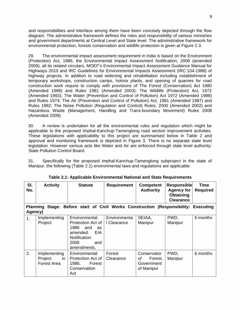
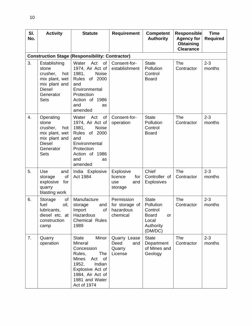
Contents
EXECUTIVE SUMMARY I
I. INTRODUCTION 1
A. Project Background and Rationale 1 B. Project Road 2 C. Objective and Scope of the Study 5 D. Methodology Adopted for EIA Study 5 E. Structure of the Report 7
II. POLICY, LEGAL AND ADMINISTRATIVE FRAMEWORKS 8
A. National (India) Environmental Policy Framework 8 B. International Treaties and Relevance to the Project 12 C. ADB Safeguard Policy Statement Requirements 13 D. Category of the Project 13
III. PROJECT DESCRIPTION 20
A. Type of Project 20 B. Need for the Project 20 C. Location and Features of the Project Road 21 D. Engineering Surveys and Investigations 27 E. Traffic Surveys 27 F. The Design 33 G. Project Facilities 49 H. Proposed Right of Way 50 I. Land Acquisition 51 J. Safety Features 51 K. Drainage Design Standards 52 L. Recommendation for Bridges 52 M. Roadside Ditches / Drains 53 N. Design of Highway Tunnel 54 O. Shifting of Utilities 55 P. Road Construction Materials 55 Q. Project Cost 56 R. Construction Packaging and Implementation Schedule 56 S. Project Benefits 56
IV. DESCRIPTION OF THE ENVIRONMENT 58
A. Introduction 58 B. Physical Environment 58 C. Biological Environment 85 D. Socio-economic Environment 96
V. ANTICIPATED ENVIRONMENTAL IMPACTS AND MITIGATION MEASURES 101
A. Introduction 101 B. Positive Environmental Impacts due to improvement of subproject road sections 102 C. Adverse Environmental Impacts due to improvement of subproject road sections 102 D. Impacts Related to Project Location, Preliminary Planning and Design 103 E. Environmental Impacts - Construction Stage 106
F. Environmental Impacts - Operation Phase 140 G. Cumulative and Induced Environmental Impacts 141 H. Potential Environmental Enhancement/ Protection Measures 144
VI. CLIMATE CHANGE IMPACTS AND RISKS 145
A. Climate Change Mitigation 145 B. Climate Risks and Adapation Needs 147
VII. ANALYSIS OF ALTERNATIVES 150
A. Introduction 150 B. ‘With Project’ and ‘Without Project’ Scenario 150 C. Location and Alignment Alternatives 155 D. Alignment Modifications due to Environmental Considerations 158 E. Engineering / Technological Alternatives 158
VIII. PUBLIC CONSULTATION AND INFORMATION DISCLOSURE 159
A. Objectives of Consultations 159 B. Methodology used for Consultations 159 C. Identification of Stakeholders 160 D. Results of Consultations 165 E. Interaction with Local/National and International NGOs 166 F. Public Disclosure 167
IX. ENVIRONMENTAL MANAGEMENT PLAN AND GRIEVANCE REDRESS MECHANISM168
A. Introduction 168 B. Objectives of Environmental Management Plan 168 C. Impacts and Mitigation Measures 168 D. Environmental Monitoring and Reporting Program 171 E. Environmental Reporting System 172 F. Institutional Requirements 185 G. Environmental Management Budget 189 H. Grievance Redress Mechanism 192
X. CONCLUSIONS AND RECOMMENDATIONS 194
Table 1: List of Subprojects included in the Project ................................................................... 2
i
EXECUTIVE SUMMARY
A. Introduction
1. This report summarizes the findings and results of the Environmental Impact Assessment (EIA) for Imphal-Kanchup-Tamenglong Road section (non-sample subproject). This subproject is covered under Tranche 1 of ADB’s SASEC Regional Road Connectivity Investment Program in India. The subproject road is located in Manipur State of India. The report also briefly describes the Project, existing environmental conditions in the project area, anticipated environmental impacts and corresponding mitigation measures, public consultation process, the environmental management plan (EMP) and its monitoring plan. 2. The Environmental Impact Assessment (EIA) for the proposed subproject has been carried out as part of project preparation and in compliance with Environmental Assessment and Review Framework (EARF1) for the Project.
B. Description of the Project
3. The project road starts at a Imphal City and ends at Tamenglong covering a total length of 111.055 kms. The alignment passes through districts of West Imphal and Tamenglong connecting major settlements Imphal, Kangchup, Haochong, Bhalok and Tamenglong. The initial 15 km of project road alignment from Imphal to Kangchup is an existing road in plain terrain, whereas alignment between Kangchup to Tamenglong (about 96 km) is new greenfield alignment mostly located in mountainous terrain. The present road section is proposed for improvement and upgradation to four land (in plain areas) and two lane (in hilly terrain) configurations with shoulders and side drains. Table 1 shows information about the Project Road.
Table 1: Information of the Project Road
Name of the Project Subproject
No. Project
Length (km) Districts State
Improvement and Upgradation of Imphal-Kanchup-Tamenglong Road Section in the State of Manipur
Tranche 1 non-sample subproject No. 3
111.055 Imphal West and Tamenglong
Manipur
4. The project road provides shortest connectivity for the State of “East West Corridor” of the National Highway Authority of India. This shall also reduce the distance to Guwahati, the commercial hub of the North East, from Imphal by at least 90 (ninety) Kms as compared to the existing route via Dimapur. The project road starts at the crossing location of NH 37 on the Flyover in central Imphal City. From start of the project, the 2 lane standard flyover and its approaches with slip road on either side extends for a length of 400m.Then there is existing 4-lane divided carriageway in about 1.46 km length. Further the existing intermediate lane bituminous road continues, upto Kangchup for about 13 km. Alignment further traverse on hilly, terrain towards Haochong settlement via existing KT mud road accessible only in dry season. It further traverses the hills connecting Bhalok and terminates at Tamenglong. Major length of the
1 Environmental Assessment and Review Framework for proposed IND: SASEC Road Connectivity Investment Program, ADB, December 2013.
ii
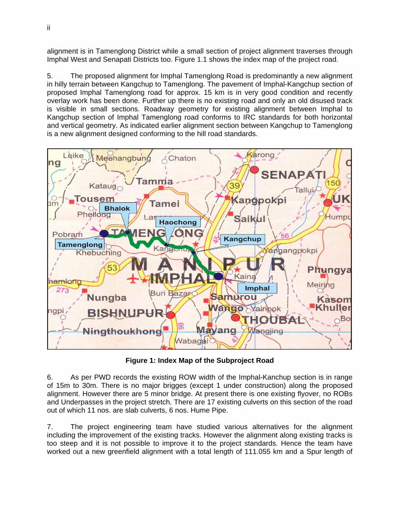
alignment is in Tamenglong District while a small section of project alignment traverses through Imphal West and Senapati Districts too. Figure 1.1 shows the index map of the project road. 5. The proposed alignment for Imphal Tamenglong Road is predominantly a new alignment in hilly terrain between Kangchup to Tamenglong. The pavement of Imphal-Kangchup section of proposed Imphal Tamenglong road for approx. 15 km is in very good condition and recently overlay work has been done. Further up there is no existing road and only an old disused track is visible in small sections. Roadway geometry for existing alignment between Imphal to Kangchup section of Imphal Tamenglong road conforms to IRC standards for both horizontal and vertical geometry. As indicated earlier alignment section between Kangchup to Tamenglong is a new alignment designed conforming to the hill road standards.
Figure 1: Index Map of the Subproject Road 6. As per PWD records the existing ROW width of the Imphal-Kanchup section is in range of 15m to 30m. There is no major brigges (except 1 under construction) along the proposed alignment. However there are 5 minor bridge. At present there is one existing flyover, no ROBs and Underpasses in the project stretch. There are 17 existing culverts on this section of the road out of which 11 nos. are slab culverts, 6 nos. Hume Pipe. 7. The project engineering team have studied various alternatives for the alignment including the improvement of the existing tracks. However the alignment along existing tracks is too steep and it is not possible to improve it to the project standards. Hence the team have worked out a new greenfield alignment with a total length of 111.055 km and a Spur length of
iii
4.16 km to Haochong. To reduce the length an option of a 1.45 km long tunnel from km 57.850 to km 59.300 has been studied. Table 1.2 present the salient features of the exiting project road. 8. Considering the existing conditions and projected traffic, it is proposed to improvement of 7.4 Km length to four lane divided carriageway, 7.3 km length of 2 lanes with paved shoulder and 2 lane hill section in the rest section. A Spur of 4.16km to Haochong has also been included. Considering the savings in travel time and vehicle operating cost in future a 1.44 km long single tube bidirectional tunnel has been recommended near Sangpei and Nagajeng village which reduce the length of the project road by about 7 kms.
C. Description of the Environment
9. As defined in the scope of works baseline data on various physical, biological and social-economic aspects have been collected, analyzed and compiled in order to get the true picture of the existing environment condition in the project influence area.
1. Physical Environment
a. Meteorological Conditions
10. The climate of subproject areas is subtropical temperate. Rainfall is relatively abundant and widespread. The rainy season starts in June with the onset of the south-west monsoon and last upto September. Intermittent rains continue even upto October along with the retreat of the monsoon. The summer months are never oppressive with the average maximum temperature fluctuating from 32C to 35C during April-June, the mercury seldom going beyond 37C. 11. The climate of Imphal West district is warm and temperate in Imphal. In winter there is much less rainfall than in summer. The Köppen-Geiger climate classification is Cwa. The average annual temperature in Imphal is 21.1°C. The average annual rainfall is 1589 mm. The driest month is December with 3 mm rainfall. Most precipitation falls in June, with an average of 359 mm. The warmest month of the year is June with an average temperature of 24.6 °C. In January, the average temperature is 14.5°C. It is the lowest average temperature of the whole year in Imphal. The difference in precipitation between the driest month and the wettest month is 356 mm. The average temperatures vary during the year by 10.1°C. 12. In Tamenglong district the climate is warm and temperate in Tamenglong. In winter there is much less rainfall in Tamenglong than in summer. The Köppen-Geiger climate classification is Cwa. The average annual temperature in Tamenglong is 18.5°C. The average annual rainfall is 3336 mm. The driest month is December with 8 mm. Most precipitation falls in July, with an average of 728 mm. The warmest month of the year is August with an average temperature of 22.2 °C. In January, the average temperature is 12.2°C. It is the lowest average temperature of the whole year. The difference in precipitation between the driest month and the wettest month is 720 mm. The average temperatures vary during the year by 10°C.
b. Topography, Geology and Soils
13. Topography: Topographically, the state is divided according to land elevations (lower hills – altitude ranging from 270 to 1,500 meters; mid hills – 1,500 to 2,000 meters; higher hills – 2,000 to 3,000 meters; alpine zone - above 3,900 meters with vegetation and snow bound land – very high without vegetation up to 8,580 meters). The project road is located in lower hills zone with altitude ranging from 500 to 1250m above MSL. It mostly passes through hilly terrain.
iv
Geographically the project road lies in the North-Eastern Himalayas between 27000’46” to 28007’48” North latitude and 88000’55” to 88055’25” East longitude. 14. Land Use: The existing land use along the project road is mostly agricultural mixed with roadside development in plain terrain and vegetative and forested on hilly terrain. The initial 4.7 km length of Imphal-Kanchup-Tamenglong Road is in urban area and from Km 4+70 to 14+700 (Kanchup) is in rural area. Project alignment beyond Kanchup is predominantly a new alignment along hills. A small section of alignment for approx. 4 km when passing through Imphal town has both residential and commercial settlements on both sides. However, since alignment already is 2 lane with paved shoulder, it would have minimal impact on existing structures on account of geometric and junction improvement. Patches of agricultural activities are also noticed on hills in this section. 15. Data obtained from IRS-P6 LISS-IV 2011 satellite image of the project area shows that about 20% of the project area is covered by thick plantation and 41% by thin plantation followed by degraded forest land (17%), agricultural land (12%), and settlement areas (7%). Water bodies and rivers cover about 3% land area in the project road. 16. Geology: Geologically, Manipur state belongs to the young folded mountains of the Himalayan system. The rocks in the state vary from upper cretaceous to the present Alluvium. The oldest rocks found in Manipur are mainly confined in the eastern part of the State close to Indo-Myanmar border and the rocks are grouped as cretaceous rocks consisting chromite, serpentine etc. availability of Asbestos, Chromite, Copper ore, Coal, Big iron, Lignite, Lime stone, Nickel ore and petroleum is reported in some parts of the state. The common rocks found are sandstone, shale, silt, stone, clay stones and slates. The rock system is weak and unstable prone to frequent seismic influence. The state is also seismically active and characterized by frequent landslides. The proposed project roads fall under the Seismic Zone IV, which is a susceptible to major earthquake as per the seismic zone map of India (IS 1893 - Part I: 2002). 17. Soils: The characteristics of soil of the project area (Imphal-Kunchuo-Tamenglong Road corridor) vary from place to place due to topographical variations. The soil in general is loamy sand to silty clay loam with a depth of 30 cm to 100 cm and in some cases even more than 120 cm. It has less water holding capacity and is dry in nature. Chemically acidic soil abound resulting from the washing down of the salts in rainwater and also on account of leaching effect. The pH value varies from 7.3 to 7.92. The soils are characterized by low to high organic matter (2.5-4 percent, in some places even more than 5 percent) with low action exchange capacity and high lime requirement. Notwithstanding the relatively high organic matter content, the nitrogen content in the soil is low.
c. Water Resources and Hydrology
18. The state has vast water resources in the form of lakes, ponds, rivers and streams, some with marshy areas. It has abundant of water potential both ground as well as surface water. Important rivers that flows through the project region are the Nambul, the Ijei, the Bakua, the Irang, the Dingua, and the Iring. The main rivers flowing in the Tamenglong District which will be transverse proposed alignment are Irang, Iring, Ijei (Aga) river. The surface water bodies such as Ijei, Irang and Iring Rivers are close to Project road alignment. The Irang River distance from road varies from 10 to 20 m from the Project road of chainage 65.700 km to chainage 70.000 km. The Ijei River distance from road varies from 10 to 35 m from the Project road of chainage 34.900 km to chainage 36.700 km. In addition to this, many of springs (Jhora) are crossing the Project road.
v
d. Water Quality
19. In order to represent the true profile of the project area, samples from major surface water source through which the project road runs were collected and analysed as per IS- 2488 (Part I-V). Ground water (drinking water) samples were analyses as per IS: 10500-1991. 20. Water quality is monitored at five locations in order to represent the true profile of the project area. Results show that the pH of the sampled water in the region is well within permissible limits (6.5 – 7.5). In the ground water samples collected from bore well at Kangchup bazar show highest value of the total dissolved solids of 244mg/l which is well within the permissible standards. Total hardness as CaCO3 in the water sample from Irang river is found at 45.6 mg/l which is highest in all samples but very less than the limit (300mg/l) prescribed for drinking water standard limits. BOD level for all analysed water samples is higher than the permissible standards. Other parameters analysed like chloride, sulphate, fluorides are found well within standards. Overall the ground water quality in the project areas in good.
e. Air Quality
21. Ambient air quality in the state is quite pure compared to other neighbouring states. Except for few urban centres like Imphal and Tamenglong, the ambient air quality is good. Ambient air quality for particulate matters (PM10 and PM2.5), SO2, NOx & Pb was monitoring at three locations along the project road. 22. Out of three locations of air monitoring the SPM concentration at AQ1 marginally exceeds permissible limits for residential zone i.e. 200 μg/m3 prescribed by MoEF. While at other locations AQ2 & AQ3 the SPM conc. is well within limits. While PM10 concentration at all the monitored locations less than the new permissible limit i.e. 100 μg/m3 prescribed by MoEF for sensitive areas. Other parameters monitored i.e. PM2.5, NOx. SO2 were found within the permissible limits for all the locations. Overall the air quality in the project area in not an issue.
f. Noise Levels
23. Noise levels were monitored at three locations along the project road. It is found that at all the three locations, the average day time noise level varies from 42.5 dB(A) to 58.2 dB(A), whereas average night time noise level ranges from 28.1 dB(A ) to 42.5 dB(A). 24. The recorded noise level is marginally higher than the permissible limits for residential area prescribed by CPCB and also by World Bank EHS standards of 55 dB(A) and 45 dB(A) for day time and night time respectively. Night time noise level readings were taken upto 10 pm only as after 10 pm no traffic movements were observed. This noise is mainly from vehicular traffic and local domestic/commercial activities.
2. Biological Environment a. Vegetation and Forests
25. In spite of its small size, the state’s vegetation is rich and varied in character. This is because of its different climatic conditions found in the state and its peculiar physiography. The forest area of the state falls into four distinct zones viz. i) Burma drainage forests, ii) Urkul pine forests, iii) forests overlooking the valley and iv) Barak drainage forests.
vi
26. Blessed with an amazing variety of flora and fauna, 67% of the geographical area of Manipur is hill tract covered forests. Depending on the altitude of hill ranges, the climatic condition varies from tropical to sub-alpine. The wet forests and the pine forests occur between 900-2700 m above MSL and they together sustain a host of rare and endemic plant and animal life. Coveted the world over as some of the most beautiful and precious blooms, orchids have an aura of exotic, mysteries about them. 27. Vegetation along the project road sections Imphal-Kanchup-Tamenglong, are mostly covered by the agriculture, thick grass and secondary Moist Deciduous Forest. 28. About 6.02 km length of the proposed project road section in hilly terrain between Kanchup-Tamenglng passes Kangchup –Makang Reserve Forest area. Starting from local stream Bangla to boundary of Wapong village (chainage 26+000 to Chainage 32+000, length 6.0 km) alignment transverse through forest area. 29. In plain terrain from starting point at chainage km 0.000 to 5+000 the land use is of built-up (major settlements Imphal city) and from chainage 5+000 to 15+000 the landuse of mixed type of residential and agriculture. While in hilly terrain at chainage km 15+000 onwards landuse is mixed of built-up (small settlements), agriculture and unclassified forests area of Senapati Forest Division and Tamenglong Forest Division. 30. Details of the forest locations along the project road sections are listed in Table 2.
Table 2: Details of Forest Locations along the Project Road section
Sl. No. Name of Reserve / Protected Forest District Chainage
From (Km) To (km) 1. Kangchup –Makang Reserve Forest Senapati 26+000 32+000
Length (Km) of Project section Road passing through Reserve / Protected Forest
6.0 Km
Source: Field Survey carried out by the Consultant Team, 2014
31. Field survey has been carried out to identify the number and type of trees to be affected by the proposed improvement work of main alignment. It is envisaged that about 2732 trees existing within the proposed formation width of the project road. Among these trees 1351 are on left side and 1381 tress are on right side of the road while travelling towards Tamenglong. These trees are likely to cut for widening of the road. The type of trees to be cut are local invasive species and do not have conservation status. Local forest department has been consulted to know the presence of any rare or endangered and they confirmed that the identified species are not included in the list of protected species.
b. Wildlife and Protected Areas
32. The State has rich wildlife and has long network of protected area. In order to protect the rich flora and fauna of Manipur from the poacher, the Government has established parks and sanctuaries. The state’s protected area network comprises of five wildlife sanctuaries and two national parks. Recognizing the importance of this region as one of the hot spots, majority of the biodiversity rich areas of the state has been placed inside the protected area network system comprising mainly of the National Park and Sanctuary.
2 The status of the forest is not clear during the survey. Project team is coordinating with State Forest
Department to know the nature of forest.
vii
33. About 6 km length of the project road (between km chainage 26.0 to km 32.0) passes through Kangchup-Makang Reserve Forest. However the project road neither encroaches nor passes by any of the protected areas of Manipur. Informal interviews were held with the local villagers, livestock herders to gather information on the presence of wildlife and their habitats along the project rods. Officials from Wildlife division including Chief Wildlife Warden and Chief Conservator of Forests were also consulted in the process. Office of the Chief Conservator (Wildlife) informed that there are no protected areas along the proposed alignment of the Imphal-Tamenglong Road Section. 34. There are no key biodiversity areas within the buffer distances of 1- and 10-km. Within a 50km buffer zone from the road alignment there are 3 key biodiversity areas, these are the Zeiland Lake Sanctuary, Jiri-Makru Wildlife Reserve, Loktak Lake and Keibul Lamjao National Park. 35. Along the road alignment is an area that is known to harbor various wildlife species and based on distribution maps there are 79 species known to occur whose native range coincides with the road impact area. Of the species known to occur in the project area, 5 are critically endangered and 8 are endangered. 36. The critically endangered species are: Aythya baeri Baer's Pochard, Gyps bengalensis White-rumped Vulture, Gyps tenuirostris Slender-billed Vulture, Houbaropsis bengalensis Bengal Florican, and Sarcogyps calvus Red-headed Vulture. While the endangered species are: Cairina scutulata White-winged Duck, Sterna acuticauda Black-bellied Tern, Axis porcinus Hog Deer, Hadromys humei Hume’s Rat, Hoolock hoolock Western Hoolock Gibbon, Manis pentadactyla Chinese Pangolin, Prionailurus viverrinus Fishing Cat, and Rucervus eldii Eld's Deer.
3. Socio-economic Environment a. Demography
37. Manipur is one of the sisters’ states in north eastern state a population of 2.38 million with about more than 75 percent of the population living in the rural areas. The human population density is very less (only 107 persons/km2) compared to 149 persons/km2 for the north eastern region. Sex ratio is 978 against the 936 in the region. The demographic feature of north eastern states is unique in that there are more than 29 recognized tribes, which inhabit mostly the hill areas and each with distinct culture, ethos, and traditional knowledge systems. The major minority groups in the state namely Aimol, Anal, Angami, Chiru, Chothe, Hmar, Kabui, Kacha Naga, Mizo, Mao, Lusai etc. The majority of the people survive on subsistence economy based mainly on the agriculture, supplemented with limited horticulture, animal husbandry, crafts/handloom, etc.
b. Land Resources
38. The area available for land utilization in the state is about 19052 sq.km out of the total geographical area of 22327 sq.km. This means about 85 percent of the area in the state in available under various land uses. Major portion of the land use is under forest cover covering about 70 percent of the land use area. About 8 percent area is under gross cropped area. Agriculture is the second major land use in area.
viii
39. Agriculture is the mainstay of the people. It contributes major shares in the state domestic product and provides employment to about 63 percent of total working force in state. Total net sown area is 160,000 hectares. Rice is principal food grain followed by maize and millets. 40. Though the state has no marine fishery, it has vast inland fishery resources like ponds, tanks, naturals lakes, marshy areas, swampy areas, rivers, reservoirs, submerged cropped land, paddy field etc. The largest source of fish is the Loktak Lake. The production of fish in Manipur for the year 2001-02 was estimated to be 16.5 thousands tones as against the 16.05 in thousand tons in the year 2000-01 showing an increase of 2.8 percent over the previous years.
c. Infrastructure
41. Transportation system is a key factor in the socio-economic development of any state. There is practically no railway network in the state. Two rail heads – one at Dimapur in Nagaland (215 km away from Imphal) and the other at Jiribam (225 km away from Imphal) serves the state. The state has one airport at Imphal, which connects up with the rest of the country. Waterways are also not feasible. Roads, therefore, constitute the only means of transport system in the state for movement of men, materials and services within and outside the state. The total road network stands at around 7200 km, of which 2600 km are unsurfaced roads. 42. The state has endowed with mineral resources. The main mineral reserves in the state includes lime stone (14.8 thousand tons), clay (2.5 thousand tons), and chromite (0.1 thousand tons). For exploiting the mineral resources, it is important to provide a good road and rail infrastructure. 43. The north eastern region has the potential to emerge as a strategic base for domestic and foreign investors to tap the potential of the contiguous markets of China, Myanmar, Lao PDR, Nepal, Bhutan and Tibet. This calls for converting the unauthorised trade into authorised trade, at the policy level as well as at the ground level. The BIMST-EC (Bangladesh-India-Myanmar-Sri Lanka-Thailand Economic Cooperation) initiative is creating an enabling environment for rapid economic development through identification and implementation of specific cooperation projects in the sectors of trade, investment and industry, technology, human resource development, tourism, agriculture, energy, infrastructure and transportation.
D. Analysis of Alternatives
44. Since the Imphal-Kunchup section involves improvement of the existing road, only one alternative alignment was considered for this section. For Kunchup-Tamenglong sections, various alternate alignment options were syudies including option of a Tunnel. Besides this an evaluation has been carried out for the 'with’ and ‘without’ project situation-in terms of the potential environmental impacts for the justification of the project. On the basis of analysis we can say that project acquires positive/beneficial impacts “With” project scenario and will greatly improve the environment and enhance social and economic development of the region compared to “Without” project scenario, which will further deteriorate the existing environment and quality of life.
E. Consultation, Disclosure and Grievance Mechanism
ix
45. In accordance with ADB’s Safeguard Policy Statement (SPS) 2009 and Environment Impact Assessment Notification of GoI (2006), public consultations were held, as part of environment assessment study. The consultation undertaken with project beneficiaries, local/ government officials, community leaders, women groups, NGO’s, stakeholders in corridor of impact and people likely to be effected due to the project on various issues affecting them and incorporation of various measures pertaining to environmental issues based on the responses from the people. 46. Both formal and informal modes of consultation were used in the public consultation process for the project. Consultation with the stakeholders, beneficiaries, and community leaders were carried out using standard structured questionnaires as well as unstructured questionnaires. In addition, focused ground discussions (FGDs) and personal discussions with officials, on-site discussion with project affected stakeholders, and reconnaissance visits have also been made to the project areas. The attempts were made to encourage participation in the consultation process of the Government officials from different departments that have relevance to the project. Same way, local people from different socio economic backgrounds in the villages as well as urban areas along the road alignment and at detours, residents near the existing road, women representatives, local commuters, and other concerned were also consulted. 47. In compliance with ADB’s SPS requirements consultation will be continued throughout the project process. The consultations were conducted during preparation of the EIA. The official consultation with the key stakeholders was undertaken in the months of June 2013 to January 2014 at respective district offices and head quarter in Imphal. Various officials consulted include PWD Officials, Forest Officers, Wildlife Officials, Environmental Officers from pollution control board, statistical officer, officials from NGOs active in the project areas etc. 48. Besides interview surveys, focused group discussions (FGDs) were organized at key locations along the project roads. In total ten (10) FGDs meetings involving 193 affected people, landowners, and village authorities, were organized. Specific emphasis was given to women participants to ensure that gender concerns are addressed in the project. Out of total participants, 73 participants were from women group. 49. Most of the people interviewed strongly support the project. The people living in the entire project area expect the different project elements to facilitate transport, employment, boost economic development and thereby provide direct, or indirect, benefits to themselves. 50. It is envisaged from the interview survey that there is increased environmental awareness among the people. It can also be seen from the table that more than 76% of the persons believes the existing environmental conditions of the area is good. Over 80% of the people agreed that the quality of air, water and noise in the area is good; whereas, about 10% respondent feel that the environmental quality is being deteriorated. Poor road condition and vehicular emissions are the major sources they feel responsible for this. In case of presence of archaeological / historical the responses are very few. In case of cultural and historial sites, the response of the people is mizxed. The area experiences natural disasters i.e. floods, earthquake etc. as it also envisaged that 73% of respondent reported history of natural disaster. Only 10% people indicated that there are rare and endangered species of fauna in the forests of the region. Overall, the general environmental conditions in the region are good and people have increased environmental awareness.
x
51. The project EA will be responsible for the disclosure of this EIA in compliance to ADB’s Communication Policy 2011 and ADB SPS 2009. The draft Environmental Impact Assessment Report will be disclosed in the English language in the office of PWD. The report will also be made available to interested parties on request from the office of the PWD. Since this is Category A subproject, this draft EIA report will be disclosed to the public through the ADB website, 120 days before the approval of the respective tranche for ADB financing. This draft EIA report will also be made available to all stakeholders as part of the consultation process required under the SPS 2009. 52. A Grievance Redress Mechanism (GRM) has been proposed to address grievances related to the implementation of the project, particularly regarding the environmental management plan and to acknowledged, evaluated, and responded to the complainant with corrective action proposed using understandable and transparent processes that are gender responsive, culturally appropriate, and readily accessible to all segments of the affected people. Records of grievances received, corrective actions taken and their outcomes will be properly maintained and form part of the semi-annual environmental monitoring report to ADB. 53. Depending on the nature and significance of the grievances or complaints, the grievance redress mechanism (GRM) will comprise procedures to address grievances i) first at the PIU level and ii) second at the EA level and iv) third at the Grievance Redress Committee (GRC). Most serious complaints which cannot be addressed at the EA level will be forwarded to the GRC. The GRC will comprise members from the EA, IA, CSC, contractor, local community and local forestry authority.
F. Anticipated Environmental Impacts and Mitigation Measures
54. The road widening project activities can cause environmental impacts that are short, or long-term, and beneficial, or adverse, in nature. The overall long-term impacts will be largely beneficial in regard to the socio-economic environment and quality-of-life in the region. The key environmental issues associated with various aspects of the proposed project and impacts on various environmental components have been assessed for various stages i.e. (a) the project location, (b) design, (c) construction, and (d) operation.
1. Environmental Impacts Associated with Project Location, Preliminary Planning and Design
55. Location issues: Except intial 15 km section, project road alignment will pass through hilly terrain and it is greenfield alignment which would require construction of new roads. This will require acquisition of about 291 hectare (30 m ROW for 97 km length) of land for road right of way. Although land acquisition requirement has been kept to minimum level, it will have impacts on topography and change in land use in the region. Loss of agriculture land and productive soil is also anticipated due to additional land acqusition. 56. The improvement of the proposed road in greenfield area willl involve cutting, filling, and the need to cut vegetation along most of the project road length. This will have more significant impact and this matter is discussed in the following sections. 57. About 6 km length of subproject road passes through Kanchup reserve forest area. Adverse impacts due to diversion of about 18 hectares of forest land are anticipated. Also land clearing will involve cutting of about 2732 trees. Problem of soil erosion is expected in some
xi
locations. Loss of trees will be compensated by planting 8196 trees (1:3 ratio) as compensatory afforestation. 58. The project affected people will be compensated as per the provisions of a Resettlement Plans (prepared as separate report). The widening option, have been devised so as to cause minimise destruction of structures. There are private structures, few small temples, shrines and educational buildings which are coming adjacent to existing carriageway of the project roads. Care will be taken to avoid such community structures or cause damage in their relocation. There will also be a requirement to establish construction camps and related contractor’s facilities, borrow pits and quarries. These will be located in environmentally sound and socially safe areas. It is expected that construction materials for the road works will be mined only from approved quarries.
2. Environmental Impacts Due to Construction
59. Impacts on Topography, Soil and Vegetation: During the improvement works of the road section and because of felling of trees, hill cuttings, ground clearing; stone quarrying, and construction of structures etc. the micro-level topography may change. 60. During road improvement works there will be cut and fill activities, cutting of trees, stone quarrying, and construction of structures. Even with reasonable care exercised in the final design, the interaction between proposed road features and existing land features could result in significant land instabilities during construction. Thus, the following mitigating measures should be implemented:
existing vegetation including shrubs and grasses along the road (except within the strip directly under embankments or cuttings) should be properly maintained and all slopes/soil cutting areas should be revegetated as soon as construction activities are completed,
excavation and earthworks should be mainly undertaken during the dry season when the risks from erosion and silt run-off are least,
sites for quarrying, borrowing and disposal of spoils are to be confirmed according to the applicable laws and regulations in the state and the practices followed in recent/ongoing projects of international level,
controlled and environmentally friendly quarrying techniques should be applied to minimise erosions and landslides,
cut material should be disposed of in suitable depressions, materials that will be used for surface dressing will consist of aggregates and
gravel, and must not contain silt, and Internationally accepted best practice engineering approaches will be
incorporated into contract documents and monitored during construction.
61. Impacts on Surface and Groundwater Quality, Drainage and Hydrology: A number of rivers and streams crossed the project road. The improvement of the road may result in disruptions to the natural hydrology and water mismanagement that may lead to further problems of soil erosion. Construction activities could also lead to the temporary pollution of rivers from spillage of chemicals and oil at construction sites and waste from construction camps, discharge of sediment-laden water from construction areas and uncontrolled surface water discharge over the road edge creating large–scale erosion on down-slopes. Thus the following mitigating measures are recommended:
xii
natural courses of water bodies should, as far as possible be maintained and brought back to their natural course,
all debris and vegetation, clogging culverts should be regularly cleared and disposal of construction debris in streams and rivers should be avoided,
river-bank slope stabilities should be monitored and appropriate remedial measures applied throughout the construction period,
if possible, construction work at bridge should also be avoided during the rainy season,
chemicals and oils should be stored in secure, impermeable containers, and disposed of well away from surface waters,
no vehicle cleaning activity should be allowed within 300 m of water bodies/ drains,
construction camps should be equipped with sanitary latrines, lined drainage structures should be provided, side drain waters must be discharged at every available stream crossing.
62. Air Quality: Prediction of the pollutant (CO, NOx and PM10) concentrations has been carried out using CALINE-4, a dispersion model based on Gaussian Equation. It has been observed from the model output that when the traffic volume increases, the concentration of air pollutants also increases correspondingly. However, the maximum predicted pollutant concentrations of PM10, CO and NOx over the existing ambient air quality are found to be within the National Ambient Air Quality Standards. 63. During construction, and at the micro-level only, air quality may be degraded by generation of dust (PM) and generation of polluting gases including SO2, NOx and HC for short periods from vehicular movements, site clearance, earth filling and material loading and unloading. The impacts are expected to be localised, temporary and confined to construction areas. Care should, however, be taken at sensitive urban locations so that harmful impacts can be minimised. The following actions should be implemented:
regular check-up and maintenance of construction equipment, mixing plants i.e. asphalt, concrete, and bricks, should be operated within the
permissible limits of CPCB and WB EHS, and be located away from settlements, the contractor should submit a dust suppression and control programme to the
PIU, vehicles delivering loose and fine materials should be covered to reduce spills, controlled blasting should be carried out and only with the prior approval of the
site Engineer and, if required, PIU, bitumen emulsion should be used wherever feasible, and bitumen heaters should be used and the use of wood for fuel should be
discouraged or prohibited.
64. Noise Level: With the exception of the Imphal city, the ambient noise level along the road sections is within standards. During the construction period, noise will be generated from the operation of heavy machinery, blasting works, the haulage of construction materials to the construction yard and the general activities at the yard itself. 65. Noise levels were predicted using Federal Highway Administration's Traffic Noise Model (FHWA TNM) which helps for highway traffic noise prediction and analysis. It is observed that the noise levels (Leq) near the receivers are found to be higher than desired levels for the respective categories. The maximum predicted value 65.5 dB(A) is recorded at the receiver
xiii
located close to Section 1 of the monitoring site. The predicted levels show increase in noise levels for future years at all receivers considering increase in traffic volume. 66. Noise and vibration will be unavoidable but the impact will only be temporary and will only affect people living or working near piling locations. Mitigation measures should include (a) provision of noise barriers at sensitive locations, (b) construction machinery should be located away from settlements (c) careful planning of machinery operation and the scheduling of such operations can reduce noise levels, (d) controlled blasting (if any) should only be carried out with prior approval from the Engineer in charge, and (e) contractors should be required to fit noise shields on construction machinery and to provide earplugs to the operators of heavy machines. 67. Flora and Fauna: Since about 6 km length of the project roads passes through forest areas, it may cause adverse impacts on flora and fauna of the area. Also acquisition of forest land (18 hectares) may add minor impacts on the presence of flora and fauna in the forests. Removal of the existing vegetative cover and the uprooting of about 2732 trees is an unfortunate activity, which may reduce the ecological balance in the areas. This may also enhance soil erosion problem. 68. To minimise adverse impacts on flora such as trees, contract documents should specify that (a) all wood building material for workers’ housing should be brought from outside the project area, (b) workers should be supplied with non-wood fuels such as kerosene or liquefied petroleum gas for the duration of the contract, (c) all contract equipment and plants should be cleaned to the satisfaction of the project engineer in charge prior to their relocation to project sites; (d) during site clearance, care should be taken to ensure that the minimum area of vegetation area is affected and (e) the water sprinkling of trucks used as construction vehicles should be properly and regularly undertaken, so that dust deposition problem on vegetation are minimised. Specific measures such as i) construction facilities such as workers camp, construction camp, hot mix plant, batching plant should be located at least 1 km away from the forest area, ii) employment agreements should specify heavy penalties for illegal hunting, trapping and wildlife trading – all other ancillary works should also agree not to participate in such activities, iii) Strict anti-poaching surveillance measures need to be implemented, especially during project construction phase in the forest areas, iv) provisions of signage as a precautionary measure to provide awareness �about animal movement will be made to avoid accidents, and v) project staff and work crews should not be allowed to have fire-arms and animal traps etc.
3. Environmental Effects Related to Operation
69. Noise and Vibration, Air Pollution, Runoff, Spoils of Hazardous Materials: The current traffic flows along the project roads is expected to increase because of improved economic activities associated with better access. The larger numbers of vehicles will be an additional source of noise and gaseous emissions. Traffic volumes will, however, remain low and this should not be a significant impact. Repairs to culverts and new drainage work will eliminate/ reduce the soil erosion problems presently caused by poor cross drainage. 70. Flora and Fauna: Positive impacts on terrestrial ecology are expected during the project operation stage due to the increase in vegetation and landscaping along the subprojects road. The project will coordinate with the local communities to maintain and enhance the trees planted along the road sections.
xiv
71. Land Use and Settlements: The likely impacts on land use and settlement patterns are limited. Improved access will inevitably lead to increased in and out migration, but this is likely to occur gradually and over a prolonged period. There will be time for new residential areas to be established. There may, however, be a need to control ribbon development.
4. Potential Environmental Enhancement/ Protection Measures
72. In order to improve the environment, additional measures were also proposed during construction for the following: (a) sanitation and housekeeping at the labour/ construction camps (b) provision of water supply (c) hygiene and provision of toilet facilities, (d) sewerage and waste disposal (e) first aid, (f) maintenance of buildings and facilities (g) identification of debris disposal sites, and (h) rehabilitation of quarry and borrow pits.
G. Environmental Management Plan
73. A fully budgeted environmental management plan has been prepared for mitigation/management/ avoidance of the potential adverse impacts and enhancement of various environmental components along the project road. For each mitigation measures to be carried out its location, timeframe, implementation and overseeing/ supervising responsibilities has been identified. Monitoring plan for construction and operation phase has been framed to ensure effective implementation of EMP. 74. The monitoring program included performance indicators for water, air, and noise level monitoring, frequency of monitoring, and institutional arrangements of the project in the construction and operation stages, along with the estimated cost. The reporting system included roles and responsibilities of each party involved in the project implementation i.e. PIU, Supervision Consultant and Contractors and reporting mechanisms during implementation and operation phases. 75. An environmental management budget of INR 3,453,075 (Indian Rupees Three million sixty three one thousand and seventy five only) (US$ 0.57 milion) has been estimated for implementation of the environmental management plan. This budget also includes cost of environmental monitoring and associated trainings.
1
I. INTRODUCTION
A. Project Background and Rationale
1. ADB has a regional cooperation program in four South Asian countries: Bangladesh, Bhutan, India and Nepal, called South Asia Subregional Economic Cooperation (SASEC3), which has been supporting regional cooperation in the transport sector through SAARC4 and BIMSTEC5 over a decade. Major contributions in this regard include assisting the SAARC Regional Multimodal Transport Study (SRMTS)6 and BIMSTEC Transport Infrastructure and Logistics Study (BTILS).7 A series of SASEC Trade Facilitation and Transport Working Group meetings have endorsed ADB preparation of a project to improve the most critical corridors connecting regional countries. Further to initiate connectivity between South Asia and South East Asia and as a follow on activity of the BTILS, strategic roads connecting Bangladesh, India and Myanmar are currently being studied. 2. The present study section, Imphal – Tamenglong is part of state highway network and it will feed traffic to the Asian Highway (AH-1) road at Imphal. AH 1 is the longest route of the Asian Highway Network, running 12,845 miles (20,557 km) from Tokyo, Japan via Korea, China, Southeast Asia, India, Pakistan, Afghanistan and Iran to the border between Turkey and Bulgaria west of Istanbul where it joins end-on with European route E80. In India AH 1 passes through Numaligarh - Golaghat - Garampani - Barpathar - Naojan - Bokajan - Dimapur - Kohima - Tadubi - Senapati - Kangpokpi - Imphal - Thoubal - Tengnoupal – Moreh (Myanmar border) 3. Imphal- Kangchup –Tamenglong- Tousen- Haflong Road (the project road), is located in the State of Manipur. It passes through the districts of Imphal West and Tamenglong and is 111.055 km long. The project road provides shortest connectivity for the State of “East West Corridor” of the National Highway Authority of India. This shall also reduce the distance to Guwahati, the commercial hub of the North East, from Imphal by at least 90 (ninety) Kms as compared to the existing route via Dimapur. The project road starts at a Rotary in Kangla in central part of Imphal City and ends at Tamenglong. The alignment passes through Imphal, Kangchup, Haochong, Bhalok and Tamenglong. The initial 15 km of this road alignment from Imphal to Kangchup is an existing road. Further alignment between Kangchup to Tamenglong (about 96 km) is new greenfield alignment. Tracks at certain sections between Kangchup to Haochong earlier known as KT road during British era are still being used by settlers to transport wooden logs during dry season and are accessible on foot or Shaktiman trucks only. Existing road surface has exposed rocks as it has not been maintained due to heavy rains in the region. The alignment has many settlements and rivers along its length. Alignment traverses through steep mountains towards Haochong settlement, via Waphong settlement. Existing alignment at certain section has very steep grades. Alignment passing through Waphong settlement crosses Ijei River very close to the settlement. 4. The present project aimed to improve 111.055 km of state network into 4/2 lane configurations between Imphal and Tamenglong in the state of Manipur.
3 South Asia Subregional Economic Cooperation (SASEC). Member countries are Bangladesh, Bhutan, India and Nepal 4 South Asian Association for Regional Cooperation (SAARC). Member countries are Afghanistan, Bangladesh, Bhutan, India, Maldives, Nepal, Pakistan and Sri Lanka 5 Bay of Bengal Initiative for Multi-Sectoral Technical and Economic Cooperation (BIMSTEC). Member countries are Bangladesh, Bhutan, India, Myanmar, Nepal, Sri Lanka and Thailand 6 SAARC Secretariat. 2007. Regional Multimodal Transport Study. Kathmandu. 7 ADB. 2008. Final Report of RETA6335: BIMSTEC Transport Infrastructure and Logistics Study. Manila.
2
5. Looking at the benefits of the project, the Government of India requested for a project preparatory technical assistance (TA) from the Asian Development Bank (ADB) to prepare an ensuing loan for the international trade corridor in Manipur State (the project). The proposed sector loan will upgrade high priority trade corridors and facilities comprising National Highways (NH) and State Highways (SH) connecting five countries: Bangladesh, Bhutan, India, Myanmar and Nepal in the northeastern part of India. Given the large scale of the program and the need to carefully study priority corridors particularly in the India - Bangladesh - Myanmar region, a sector loan approach is proposed to finance the project. 6. While approximately six road corridors have been identified for financing under the project, two sample subprojects were prepared as part of the project processing. The options and design for the remaining roads and facilities are still being studied and yet to be clearly defined. Therefore the former are selected as sample sub-projects and the latter as non-sample subprojects under the program. The list of sample subprojects and tentative non-sample subprojects are provided below in Table 1.
Table 3: List of Subprojects included in the Project No. Name of Road/Facility Length (km)
I Tranche I subprojects 1. AH-2: Panitanki (Nepal border) – Fulbari (Bangladesh border) 37.271 2. AH-48: Jaigaon (Bhutan border) – Changrabandha
(Bangladesh border) 90.56
Sub-Total-A 127.831 II Potential subprojects for succeeding tranches 1. Imphal – Moreh (Manipur) 107 2. Imphal-Wangjiang-Heirok-Machi-Khudengthabi (Manipur) 65 3. Imphal-Kanchup-Tamenglong-Tousem-Haflong (Manipur) 808 4. Greater Imphal Ring Road 37.72 5. Mechi bridge (West Bengal) 0.600 Sub-Total B 290.32 Grand Total (APPROXIMATELY) 418.151
7. This Environmental Impact Assessment (EIA) covers a non-sample subproject in the State of Manipur i.e. Imphal-Kanchup-Tamenglong-Tousem-Haflong road section. All discussions thereafter focus only on this subproject. The environmental assessment report for this non-sample subproject is prepared as part of project preparation in compliance with Environmental Assessment and Review Framework (EARF9) for the Project. B. Project Road
8. The Imphal- Kangchup –Tamenglong- Tousen- Haflong Road (the project road), is located in the State of Manipur. It passes through the districts of Imphal West and Tamenglong and is 111.055 km long. The project road starts at the crossing location of NH 37 on the Flyover in central Imphal City. From start of the project, the 2 lane standard flyover and its approaches with slip road on either side extends for a length of 400m.Then there is existing 4-lane divided
8 This was the Aerial distance estimated during project planning. However design length of the project road section between Imphal and Tamenglong is 111.055 kms. 9 Environmental Assessment and Review Framework for proposed IND: SASEC Road Connectivity Investment Program, ADB, December 2013.
3
carriageway in about 1.46 km length. Further the existing intermediate lane bituminous road continues, upto Kangchup for about 13 km. Alignment further traverse on hilly, terrain towards Haochong settlement via existing KT mud road accessible only in dry season. It further traverses the hills connecting Bhalok and terminates at Tamenglong. Major length of the alignment is in Tamenglong District while a small section of project alignment traverses through Imphal West and Senapati Districts too. Figure 1 shows the index map of the project road.
Figure 2: Index Map of the Imphal-Tamenglong Road Project 9. The proposed alignment for Imphal Tamenglong Road is predominantly a new alignment in hilly terrain between Kangchup to Tamenglong. The pavement of Imphal-Kangchup section of proposed Imphal Tamenglong road for approx. 15 km is in very good condition and recently overlay work has been done. Further up there is no existing road and only an old disused track is visible in small sections. Roadway geometry for existing alignment between Imphal to Kangchup section of Imphal Tamenglong road conforms to IRC standards for both horizontal and vertical geometry. As indicated earlier alignment section between Kangchup to Tamenglong is a new alignment designed conforming to the hill road standards. 10. As per PWD records the existing ROW width of the Imphal Kangchup section is in range of 15m to 30m. There is no major brigges (except 1 under construction) along the proposed alignment. However there are 5 minor bridge. At present there is one existing flyover, no ROBs
4
and Underpasses in the project stretch. There are 17 existing culverts on this section of the road out of which 11 nos. are slab culverts, 6 nos. Hume Pipe. 11. The project engineering team have studied various alternatives for the alignment including the improvement of the existing tracks. However the alignment along existing tracks is too steep and it is not possible to improve it to the project standards. Hence the team have worked out a new greenfield alignment with a total length of 111.055 km and a Spur length of 4.16 km to Haochong. To reduce the length an option of a 1.45 km long tunnel from km 57.850 to km 59.300 has been studied. Table 1.2 present the salient features of the exiting project road. 12. Considering the existing conditions and projected traffic, it is proposed to improvement of 7.4 Km length to four lane divided carriageway, 7.3 km length of 2 lanes with paved shoulder and 2 lane hill section in the rest section. A Spur of 4.16km to Haochong has also been included. Considering the savings in travel time and vehicle operating cost in future a 1.44 km long single tube bidirectional tunnel has been recommended near Sangpei and Nagajeng village which reduce the length of the project road by about 7 kms.
Table 4Table 1.2: Description of Imphal-Kanchup-Tamenglong Road Section Sub-project
Road Section
Length (km)
Districts Summary of General Road Condition
Imphal-Kanchup-Tamenglong Road
111.055 Imphal West and Tamenglong
The project road section (Imphal- Kangchup –Tamenglong- Tousen- Haflong) passes through two districts namely Imphal West and Tamenglong of Manipur State covering a total length of 11.055 kms. The project road starts at a Rotary in Kangla in central part of Imphal City and ends at Tamenglong. The alignment passes through settlements of Imphal, Kangchup, Haochong, Bhalok and Tamenglong. The initial 15 km of this road alignment from Imphal to Kangchup is an existing road. Further alignment between Kangchup to Tamenglong (about 96 km) is new greenfield alignment. Tracks at certain sections between Kangchup to Haochong earlier known as KT road during British era are still being used by settlers to transport wooden logs during dry season and are accessible on foot or Shaktiman trucks only. Existing road surface has exposed rocks as it has not been maintained due to heavy rains in the region.
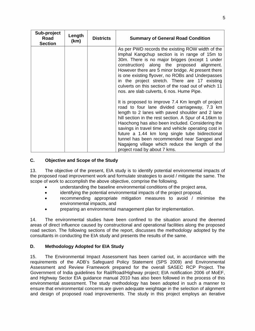
5
Sub-project Road
Section
Length (km)
Districts Summary of General Road Condition
As per PWD records the existing ROW width of the Imphal Kangchup section is in range of 15m to 30m. There is no major brigges (except 1 under construction) along the proposed alignment. However there are 5 minor bridge. At present there is one existing flyover, no ROBs and Underpasses in the project stretch. There are 17 existing culverts on this section of the road out of which 11 nos. are slab culverts, 6 nos. Hume Pipe. It is proposed to improve 7.4 Km length of project road to four lane divided carriageway, 7.3 km length to 2 lanes with paved shoulder and 2 lane hill section in the rest section. A Spur of 4.16km to Haochong has also been included. Considering the savings in travel time and vehicle operating cost in future a 1.44 km long single tube bidirectional tunnel has been recommended near Sangpei and Nagajeng village which reduce the length of the project road by about 7 kms.
C. Objective and Scope of the Study
13. The objective of the present, EIA study is to identify potential environmental impacts of the proposed road improvement work and formulate strategies to avoid / mitigate the same. The scope of work to accomplish the above objective, comprise the following.
understanding the baseline environmental conditions of the project area, identifying the potential environmental impacts of the project proposal, recommending appropriate mitigation measures to avoid / minimise the
environmental impacts, and preparing an environmental management plan for implementation.
14. The environmental studies have been confined to the situation around the deemed areas of direct influence caused by constructional and operational facilities along the proposed road section. The following sections of the report, discusses the methodology adopted by the consultants in conducting the EIA study and presents the results of the same.
D. Methodology Adopted for EIA Study
15. The Environmental Impact Assessment has been carried out, in accordance with the requirements of the ADB’s Safeguard Policy Statement (SPS 2009) and Environmental Assessment and Review Framework prepared for the overall SASEC RCP Project. The Government of India guidelines for Rail/Road/Highway project; EIA notification 2006 of MoEF, and Highway Sector EIA guidance manual 2010 has also been followed in the process of this environmental assessment. The study methodology has been adopted in such a manner to ensure that environmental concerns are given adequate weightage in the selection of alignment and design of proposed road improvements. The study in this project employs an iterative
6
approach in which potential environmental issues have been examined at successive levels in detail and specificity, at each step in the process.
16. The Environmental assessment is based on the information collected from secondary as well as primary sources on various environmental attributes. Monitoring of air, water, noise and soil quality was also carried out within the ROW and significant issues were examined during field surveys to determine the magnitude of significant environmental impacts. 17. The major steps in the EIA process for the project were as follows:
1. Collection and Analysis of Data
18. Data was collected on various environmental components such as soil, meteorology, geology, hydrology, water quality, flora and fauna, habitat, demography, land use, cultural properties etc, to establish the baseline environmental setup. Secondary data on environment for the project corridor was collected both from published and other relevant sources e.g., the Departments of Forest, Manipur State Pollution Control Board, State Statistical Department etc. The data collection from the field was completed with the help of enumerators / investigators. The interviewers were trained for filling up the Questionnaire at the site. To ensure the accuracy of the data it was collected under the supervision of the consultant.
2. Environmental Monitoring and Analysis
19. In order to assess the situation in particular sections of the road during the screening and site visit of the area, different locations were identified for monitoring and analysis the noise level, ambient air and water quality. The monitoring and analysis of water quality, air quality and noise level has been done by M/s. Greenvision, a leading environmental research laboratory based in Durgapur, West Bengal in the month of May 2014. Air quality monitoring has been carried out as per MoEF notification of November 2009 the revised Air Quality standards and the on-site monitoring results are incorporated in Chapter- 4 of this EIA report.
3. Analysis of Alternative
20. Alternate analysis for the present subproject road alignment has been made on the basis of “with” and “without” project scenario as well as alternate alignment options. The parameters considered for the analysis are the environmental as well as social features and their likely impact on the natural ecosystem.
4. Assessment of Potential Impacts
21. Potential significant impacts were identified on the basis of: analytical review of baseline data; review of environmental conditions at site; analytical review of the underlying socio-economic conditions with the project influence area.
5. Preparation of the Environment Management Plan
22. An EMP for the project is prepared to specify the steps required to ensure that the necessary measures have been taken and the same will be incorporated during construction and operation stage of the project. The EMP includes the monitoring plan giving details of the resources budgeted and the implementation arrangements.
7
E. Structure of the Report
23. This EIA report has been presented as per requirements of the ADB’s Safeguard Policy Statement (SPS) 2009. The report is organised into following ten chapters, a brief of each chapter is described below:
Chapter 1 - Introduction: This section describes the background information about the project and EIA study.
Chapter 2 - Policy, Legal, and Administrative Frameworks: this section summarizing the national and local legal and institutional frameworks that guided the conduct of the assessment.
Chapter 3 - Project Description: This section presents the key features and components of the proposed project.
Chapter 4 - Description of the Environment: This section discussing the relevant physical, biological, and socioeconomic features that may be affected by the proposed project.
Chapter 5 - Anticipated Environmental Impacts and Mitigation Measures: This section presents the environmental assessment of likely positive and adverse impacts attributed to the proposed project and concomitant mitigation measures.
Chapter 6 - Climate Change Risk Assessment: This section provides an analysis of climate change impacts and risks due to the implementation of proposed project.
Chapter 7 - Analysis of Alternatives: This section covers analysis of various alternatives considered to minimise the overall impacts of proposed development and suggest most appropriate alternatives based of detailed analysis of impact and risk associated with each alternative.
Chapter 8 - Information Disclosure, Consultation, and Participation: This section describes the consultation process undertaken during the environmental examination and its results, their consideration in the project design, and manner of compliance to the ADB’s Publication Policy and related national laws.
Chapter 9 - Grievance Redress Mechanism: This section describing the formal and informal redress procedures for registering, resolving, and reporting complaints.
Chapter 10 - Environmental Management Plan: This section discussing the lessons from the impact assessment and translated into action plans to avoid, reduce, mitigate or compensate adverse impacts and reinforces beneficial impacts. This plan is divided into three sub-sections; mitigation, monitoring, and implementation arrangements
Chapter 11 - Conclusion and Recommendation: This section stating whether there is a need for further detailed environmental studies / assessments and highlights key findings and recommendations to be implemented by the borrower.
24. An Executive Summary is also prepared and presented in the beginning of the report.
8
II. POLICY, LEGAL AND ADMINISTRATIVE FRAMEWORKS
25. India has well defined institutional and legislative framework. The legislation covers all components of environment viz. air, water, soil, terrestrial and aquatic flora and fauna, natural resources, and sensitive habitats. India is also signatory to various international conventions and protocols. The environmental legislations in India are framed to protect the valued environmental components and comply with its commitment to international community under above conventions and protocols. Asian Development Bank has also defined its Environmental and Social Safeguard policies. This assessment is about the applicability of above laws and regulations, conventions, protocols, and safeguards. This section summaries the following:
National (India) Environmental Legislation and Legal Administrative Framework, Social Safeguard Regulatory Requirements, ADB safeguard policies and categorisation of the project, Summary of international treaties and applicability to the project
1. National (India) Environmental Policy Framework
26. The legal framework of the country consists of several acts, notifications, rules and regulations to protect environment and wildlife. In 1976, the 42nd Constitutional Amendment created Article 48A and 51A, placing an obligation on every citizen of the country to attempt to conserve the environment. The national legislations are broadly divided under following categories:
Environmental Protection, Forests Conservation, and Wild Life Protection.
27. The umbrella legislation under each of above category is highlighted below:
The Environment (Protection) Act 1986 was enacted with the objective of providing for the protection and improvement of the environment. It empowers the Central Government to establish authorities charged with the mandate of preventing environmental pollution in all its forms and to tackle specific environmental problems that are peculiar to different parts of the country. Various rules are framed under this Act for grant of environmental clearance for any developmental project, resources conservation and waste management.
The Forest Conservation Act 1980 was enacted to help conserve the country's forests. It strictly restricts and regulates the de-reservation of forests or use of forest land for non-forest purposes without the prior approval of Central Government. To this end the Act lays down the pre-requisites for the diversion of forest land for non-forest purposes.
Wild Life (Protection) Act 1972 amended 2003 was enacted with the objective of effectively protecting the wild life of this country and to control poaching, smuggling and illegal trade in wildlife and its derivatives. It defines rules for the protection of wild life and ecologically important protected areas.
28. State Pollution Control Boards (SPCBs) together form the regulatory and administrative core of the part. Other Ministries/ Statutory Bodies/ Departments responsible for ensuring environmental compliance and granting various clearances includes state ministry /dept. of environment, regional offices of MoEF and state forests/wildlife departments. Their key roles
9
and responsibilities and interface among them have been concisely depicted through the flow diagram. The administrative framework defines the roles and responsibility of various ministries and government departments at Central Level and State level. The administrative framework for environmental protection, forests conservation and wildlife protection is given at Figure 2.3. 29. The environmental impact assessment requirement in India is based on the Environment (Protection) Act, 1986, the Environmental Impact Assessment Notification, 2006 (amended 2009), all its related circulars, MOEF’s Environmental Impact Assessment Guidance Manual for Highways 2010 and IRC Guidelines for Environmental Impacts Assessment (IRC:104-1988) of highway projects. In addition to road widening and rehabilitation including establishment of temporary workshops, construction camps, hotmix plants, and opening of quarries for road construction work require to comply with provisions of The Forest (Conservation) Act 1980 (Amended 1988) and Rules 1981 (Amended 2003): The Wildlife (Protection) Act, 1972 (Amended 1993); The Water (Prevention and Control of Pollution) Act 1972 (Amended 1988) and Rules 1974; The Air (Prevention and Control of Pollution) Act, 1981 (Amended 1987) and Rules 1982; The Noise Pollution (Regulation and Control) Rules, 2000 (Amended 2002) and Hazardous Waste (Management, Handling and Trans-boundary Movement) Rules 2008 (Amended 2009). 30. A review is undertaken for all the environmental rules and regulation which might be applicable to the proposed Imphal-Kanchup-Tamenglong road section improvement activities. These legislations with applicability to this project are summarised below in Table 2 and approval and monitoring framework is depicted in Figure 3. There is no separate state level legislation. However various acts like Water and Air are enforced through state level authority: State Pollution Control Board. 31. Specifically for the proposed Imphal-Kanchup-Tamenglong subproject in the state of Manipur, the following (Table 2.1) environmental laws and regulations are applicable:
Table 2.1: Applicable Environmental National and State Requirements
Sl. No.
Activity Statute Requirement Competent Authority
Responsible Agency for Obtaining Clearance
Time Required
Planning Stage: Before start of Civil Works Construction (Responsibility: Executing Agency)
1. Implementing Project
Environmental Protection Act of 1986 and as amended. EIA Notification 2006 and amendments.
Environmental Clearance
SEIAA, Manipur
PWD, Manipur
6 months
2. Implementing Project in Forest Area
Environmental Protection Act of 1986, Forest Conservation Act
Forest Clearance
Conservator of Forest, Government of Manipur
PWD, Manipur
6 months
10
Sl. No.
Activity Statute Requirement Competent Authority
Responsible Agency for Obtaining Clearance
Time Required
Construction Stage (Responsibility: Contractor)
3. Establishing stone crusher, hot mix plant, wet mix plant and Diesel Generator Sets
Water Act of 1974, Air Act of 1981, Noise Rules of 2000 and Environmental Protection Action of 1986 and as amended
Consent-for-establishment
State Pollution Control Board
The Contractor
2-3 months
4. Operating stone crusher, hot mix plant, wet mix plant and Diesel Generator Sets
Water Act of 1974, Air Act of 1981, Noise Rules of 2000 and Environmental Protection Action of 1986 and as amended
Consent-for-operation
State Pollution Control Board
The Contractor
2-3 months
5. Use and storage of explosive for quarry blasting work
India Explosive Act 1984
Explosive licence for use and storage
Chief Controller of Explosives
The Contractor
2-3 months
6. Storage of fuel oil, lubricants, diesel etc. at construction camp
Manufacture storage and Import of Hazardous Chemical Rules 1989
Permission for storage of hazardous chemical
State Pollution Control Board or Local Authority (DM/DC)
The Contractor
2-3 months
7. Quarry operation
State Minor Mineral Concession Rules, The Mines Act of 1952, Indian Explosive Act of 1984, Air Act of 1981 and Water Act of 1974
Quarry Lease Deed and Quarry License
State Department of Mines and Geology
The Contractor
2-3 months
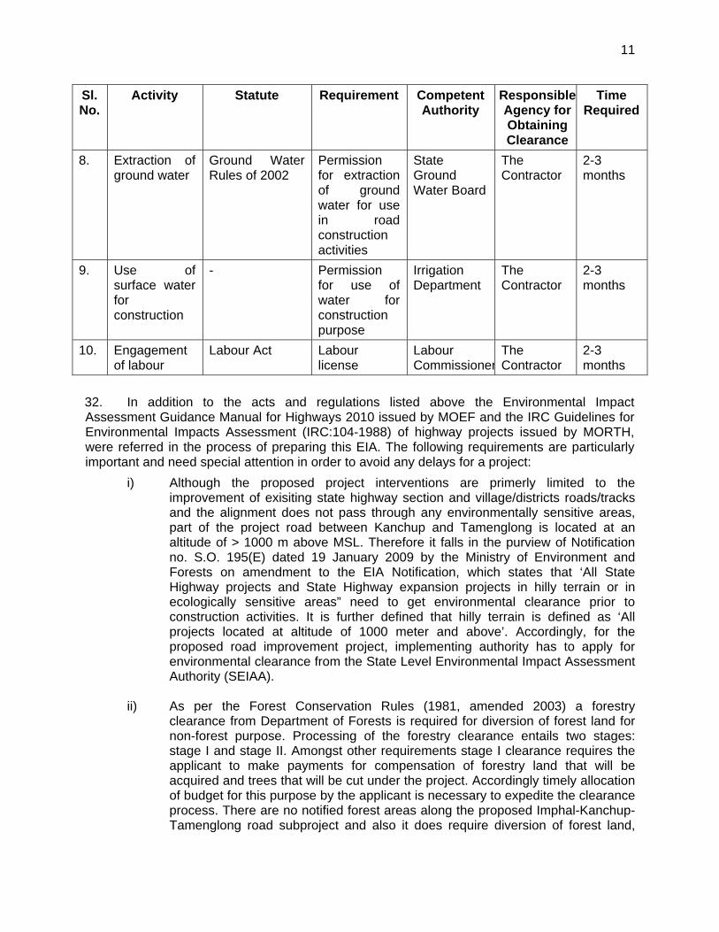
11
Sl. No.
Activity Statute Requirement Competent Authority
Responsible Agency for Obtaining Clearance
Time Required
8. Extraction of ground water
Ground Water Rules of 2002
Permission for extraction of ground water for use in road construction activities
State Ground Water Board
The Contractor
2-3 months
9. Use of surface water for construction
- Permission for use of water for construction purpose
Irrigation Department
The Contractor
2-3 months
10. Engagement of labour
Labour Act Labour license
Labour Commissioner
The Contractor
2-3 months
32. In addition to the acts and regulations listed above the Environmental Impact Assessment Guidance Manual for Highways 2010 issued by MOEF and the IRC Guidelines for Environmental Impacts Assessment (IRC:104-1988) of highway projects issued by MORTH, were referred in the process of preparing this EIA. The following requirements are particularly important and need special attention in order to avoid any delays for a project:
i) Although the proposed project interventions are primerly limited to the improvement of exisiting state highway section and village/districts roads/tracks and the alignment does not pass through any environmentally sensitive areas, part of the project road between Kanchup and Tamenglong is located at an altitude of > 1000 m above MSL. Therefore it falls in the purview of Notification no. S.O. 195(E) dated 19 January 2009 by the Ministry of Environment and Forests on amendment to the EIA Notification, which states that ‘All State Highway projects and State Highway expansion projects in hilly terrain or in ecologically sensitive areas” need to get environmental clearance prior to construction activities. It is further defined that hilly terrain is defined as ‘All projects located at altitude of 1000 meter and above’. Accordingly, for the proposed road improvement project, implementing authority has to apply for environmental clearance from the State Level Environmental Impact Assessment Authority (SEIAA).
ii) As per the Forest Conservation Rules (1981, amended 2003) a forestry
clearance from Department of Forests is required for diversion of forest land for non-forest purpose. Processing of the forestry clearance entails two stages: stage I and stage II. Amongst other requirements stage I clearance requires the applicant to make payments for compensation of forestry land that will be acquired and trees that will be cut under the project. Accordingly timely allocation of budget for this purpose by the applicant is necessary to expedite the clearance process. There are no notified forest areas along the proposed Imphal-Kanchup-Tamenglong road subproject and also it does require diversion of forest land,
12
therefore forest clearance is required as per Government of India requirements. iii) Cutting of trees in non forest land require a tree cutting permit from the local
forestry department. All trees cut under a project must be compensated by compensatory afforestation as required by the Forest Department.
iv) As per Office Memorandum (OM) issued by MOEF on 19 March 2013 the grant
of environmental clearance for linear projects including roads has been delinked from the forestry clearance procedure. Hence, after receipt of environmental clearance construction works may commence on sections/parts of a linear project that do not require forestry clearance. Construction works may commence on sections requiring forestry clearance only after receipt of the respective clearance.
v) Placement of hot-mix plants, quarrying and crushers, batch mixing plants,
discharge of sewage from construction camps requires No Objection Certificate (Consent to Establish and Consent to Operate) from State Pollution Control Board prior to establishment.
vi) Permission from Central Ground Water Authority is required for extracting ground
water for construction purposes, from areas declared as critical or semi critical from ground water potential prospective by them.
33. Before the start of civil works for the any section of the project road the project proponent (PWD Manipur) must obtain necessary clearances / permits from staturoty authorities. Procedures and steps to be followed to obtain various clearances / permits are presented in Figure 2.1 to Figure 2.3.
2. Social Regulatory Requirements of India and State
34. There are many rules and regulations framed by the Government of India for the protection of workers. Most of these legislations will be applicable to contractors in charge of construction. EA will ensure compliance to these social legislations through contractual obligation and regular checks & penalties. These legislations include The Building and Other Construction Workers (Regulation of Employment and Conditions of Service) Act, 1996; Child Labour (prohibition and Regulation) Act, 1986; Minimum Wages Act, 1948; Workmen Compensation Act, 1923; Payment of Gratuity Act, 1972; Employee State Insurance Act; Employees P.F. and Miscellaneous Provision Act, 1952; Maternity Benefit Act, 1951; Payment of Wages Act, 1936; Equal Remuneration Act, 1979; Inter-State Migrant Workmen’s (Regulation of Employment & Conditions of Service) Act, 1979; Equal Remuneration Act, 1979 etc.
3. International Treaties and Relevance to the Project
35. Government of India has signed many international treaties. GOI has also framed various laws, regulations and guidelines to meet country’s obligations under these treaties. The projects of this magnitude may contribute in meeting country’s obligation directly or indirectly. A screening was carried out of these treaties regarding its applicability to this project. Outcome of these treaties. The relevant international Treaties are:
Kyoto Protocol to the United Nations Framework Convention on Climate Change (Rectified by India in 1997): The Kyoto Protocol is an international
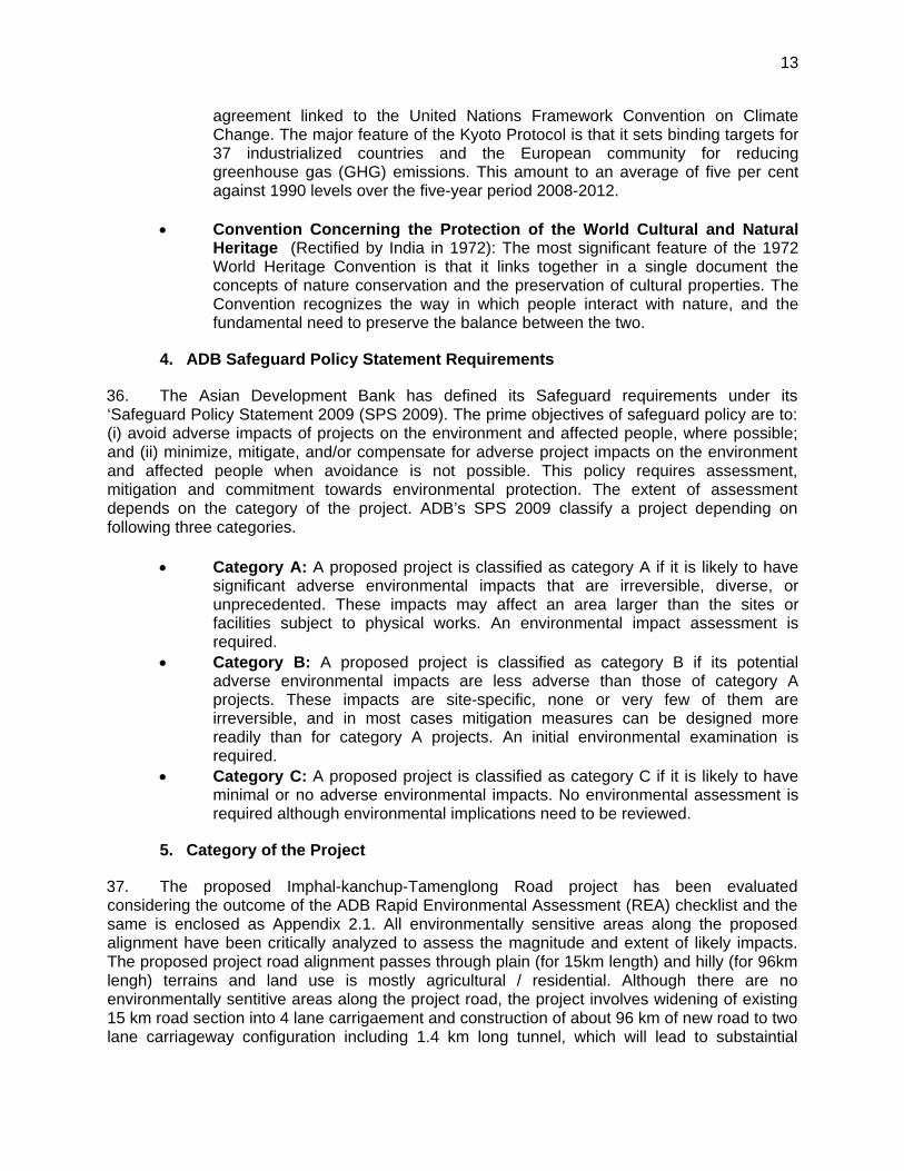
13
agreement linked to the United Nations Framework Convention on Climate Change. The major feature of the Kyoto Protocol is that it sets binding targets for 37 industrialized countries and the European community for reducing greenhouse gas (GHG) emissions. This amount to an average of five per cent against 1990 levels over the five-year period 2008-2012.
Convention Concerning the Protection of the World Cultural and Natural
Heritage (Rectified by India in 1972): The most significant feature of the 1972 World Heritage Convention is that it links together in a single document the concepts of nature conservation and the preservation of cultural properties. The Convention recognizes the way in which people interact with nature, and the fundamental need to preserve the balance between the two.
4. ADB Safeguard Policy Statement Requirements
36. The Asian Development Bank has defined its Safeguard requirements under its ‘Safeguard Policy Statement 2009 (SPS 2009). The prime objectives of safeguard policy are to: (i) avoid adverse impacts of projects on the environment and affected people, where possible; and (ii) minimize, mitigate, and/or compensate for adverse project impacts on the environment and affected people when avoidance is not possible. This policy requires assessment, mitigation and commitment towards environmental protection. The extent of assessment depends on the category of the project. ADB’s SPS 2009 classify a project depending on following three categories.
Category A: A proposed project is classified as category A if it is likely to have significant adverse environmental impacts that are irreversible, diverse, or unprecedented. These impacts may affect an area larger than the sites or facilities subject to physical works. An environmental impact assessment is required.
Category B: A proposed project is classified as category B if its potential adverse environmental impacts are less adverse than those of category A projects. These impacts are site-specific, none or very few of them are irreversible, and in most cases mitigation measures can be designed more readily than for category A projects. An initial environmental examination is required.
Category C: A proposed project is classified as category C if it is likely to have minimal or no adverse environmental impacts. No environmental assessment is required although environmental implications need to be reviewed.
5. Category of the Project
37. The proposed Imphal-kanchup-Tamenglong Road project has been evaluated considering the outcome of the ADB Rapid Environmental Assessment (REA) checklist and the same is enclosed as Appendix 2.1. All environmentally sensitive areas along the proposed alignment have been critically analyzed to assess the magnitude and extent of likely impacts. The proposed project road alignment passes through plain (for 15km length) and hilly (for 96km lengh) terrains and land use is mostly agricultural / residential. Although there are no environmentally sentitive areas along the project road, the project involves widening of existing 15 km road section into 4 lane carrigaement and construction of about 96 km of new road to two lane carriageway configuration including 1.4 km long tunnel, which will lead to substaintial
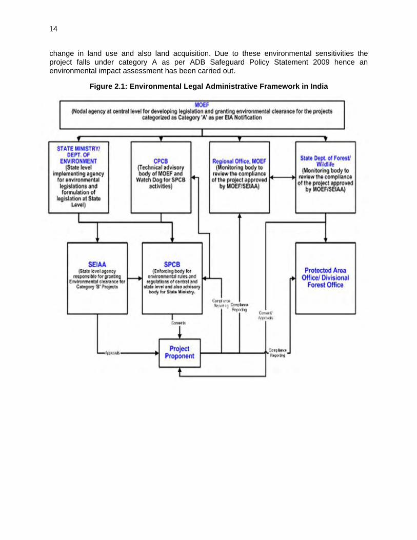
14
change in land use and also land acquisition. Due to these environmental sensitivities the project falls under category A as per ADB Safeguard Policy Statement 2009 hence an environmental impact assessment has been carried out.
Figure 2.1: Environmental Legal Administrative Framework in India
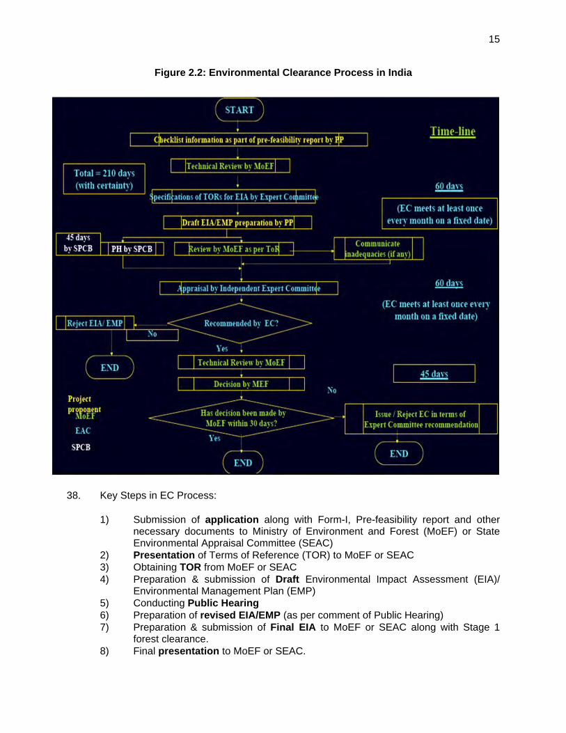
15
Figure 2.2: Environmental Clearance Process in India
38. Key Steps in EC Process:
1) Submission of application along with Form-I, Pre-feasibility report and other necessary documents to Ministry of Environment and Forest (MoEF) or State Environmental Appraisal Committee (SEAC)
2) Presentation of Terms of Reference (TOR) to MoEF or SEAC 3) Obtaining TOR from MoEF or SEAC 4) Preparation & submission of Draft Environmental Impact Assessment (EIA)/
Environmental Management Plan (EMP) 5) Conducting Public Hearing 6) Preparation of revised EIA/EMP (as per comment of Public Hearing) 7) Preparation & submission of Final EIA to MoEF or SEAC along with Stage 1
forest clearance. 8) Final presentation to MoEF or SEAC.
16
9) Obtaining Environmental Clearance.
Figure 2.3: Procedure for Obtaining Forest Clearance
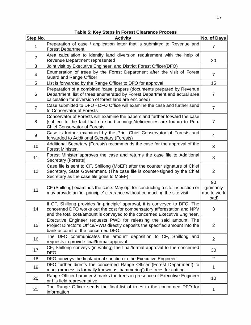
17
Table 5: Key Steps in Forest Clearance Process Step No. Activity No. of Days
1 Preparation of case / application letter that is submitted to Revenue and Forest Department
7
2 Area calculation to identify land diversion requirement with the help of Revenue Department represented 30
3 Joint visit by Executive Engineer, and District Forest Officer(DFO)
4 Enumeration of trees by the Forest Department after the visit of Forest Guard and Range Officer
7
5 List is forwarded by the Range Officer to DFO for approval 15
6 Preparation of a combined ‘case’ papers (documents prepared by Revenue Department, list of trees enumerated by Forest Department and actual area calculation for diversion of forest land are enclosed)
7
7 Case submitted to DFO - DFO Office will examine the case and further send to Conservator of Forests
7
8 Conservator of Forests will examine the papers and further forward the case (subject to the fact that no short-comings/deficiencies are found) to Prin. Chief Conservator of Forests
7
9 Case is further examined by the Prin. Chief Conservator of Forests and forwarded to Additional Secretary (Forests)
4
10 Additional Secretary (Forests) recommends the case for the approval of the Forest Minister.
3
11 Forest Minister approves the case and returns the case file to Additional Secretary (Forests)
8
12 Case file is sent to CF, Shillong (MoEF) after the counter signature of Chief Secretary, State Government. (The case file is counter-signed by the Chief Secretary as the case file goes to MoEF).
2
13 CF (Shillong) examines the case. May opt for conducting a site inspection or may provide an ‘in- principle’ clearance without conducting the site visit.
90 (primarily
due to work load)
14 If CF, Shillong provides ‘in-principle’ approval, it is conveyed to DFO. The concerned DFO works out the cost for compensatory afforestation and NPV and the total cost/amount is conveyed to the concerned Executive Engineer.
3
15 Executive Engineer requests PWD for releasing the said amount. The Project Director’s Office/PWD directly deposits the specified amount into the bank account of the concerned DFO.
2
16 The DFO communicates the amount deposition to CF, Shillong and requests to provide final/formal approval
2
17 CF, Shillong conveys (in writing) the final/formal approval to the concerned DFO.
30
18 DFO conveys the final/formal sanction to the Executive Engineer 2
19 DFO further directs the concerned Range Officer (Forest Department) to mark (process is formally known as ‘hammering’) the trees for cutting.
1
20 Range Officer hammers/ marks the trees in presence of Executive Engineer or his field representative
10
21 The Range Officer sends the final list of trees to the concerned DFO for information
1
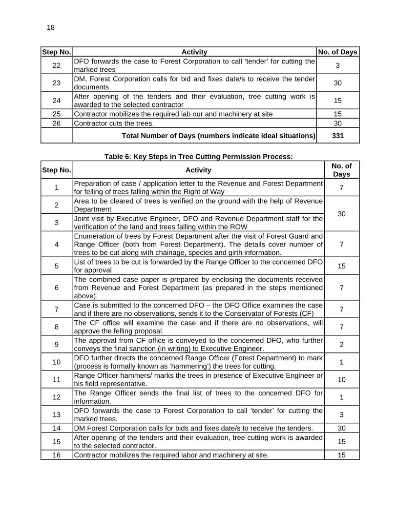
18
Step No. Activity No. of Days
22 DFO forwards the case to Forest Corporation to call ‘tender’ for cutting the marked trees
3
23 DM, Forest Corporation calls for bid and fixes date/s to receive the tender documents
30
24 After opening of the tenders and their evaluation, tree cutting work is awarded to the selected contractor
15
25 Contractor mobilizes the required lab our and machinery at site 15 26 Contractor cuts the trees. 30
Total Number of Days (numbers indicate ideal situations) 331
Table 6: Key Steps in Tree Cutting Permission Process:
Step No. Activity No. of Days
1 Preparation of case / application letter to the Revenue and Forest Department for felling of trees falling within the Right of Way
7
2 Area to be cleared of trees is verified on the ground with the help of Revenue Department
30 3
Joint visit by Executive Engineer, DFO and Revenue Department staff for the verification of the land and trees falling within the ROW
4 Enumeration of trees by Forest Department after the visit of Forest Guard and Range Officer (both from Forest Department). The details cover number of trees to be cut along with chainage, species and girth information.
7
5 List of trees to be cut is forwarded by the Range Officer to the concerned DFO for approval
15
6 The combined case paper is prepared by enclosing the documents received from Revenue and Forest Department (as prepared in the steps mentioned above).
7
7 Case is submitted to the concerned DFO – the DFO Office examines the case and if there are no observations, sends it to the Conservator of Forests (CF)
7
8 The CF office will examine the case and if there are no observations, will approve the felling proposal.
7
9 The approval from CF office is conveyed to the concerned DFO, who further conveys the final sanction (in writing) to Executive Engineer.
2
10 DFO further directs the concerned Range Officer (Forest Department) to mark (process is formally known as ‘hammering’) the trees for cutting.
1
11 Range Officer hammers/ marks the trees in presence of Executive Engineer or his field representative.
10
12 The Range Officer sends the final list of trees to the concerned DFO for information.
1
13 DFO forwards the case to Forest Corporation to call ‘tender’ for cutting the marked trees.
3
14 DM Forest Corporation calls for bids and fixes date/s to receive the tenders. 30
15 After opening of the tenders and their evaluation, tree cutting work is awarded to the selected contractor.
15
16 Contractor mobilizes the required labor and machinery at site. 15

19
17 Contractor cuts the trees 30 Total Number of Days (numbers indicate ideal situations) 187
20
III. PROJECT DESCRIPTION
A. Type of Project
39. The present report deals with the Environmental Impact Assessment of Imphal-Kanchup-Tamenglong subproject located in Manipur State included in SASEC Regional Road Connectivity Investment Program in India. The project road starts at central part of Imphal City and ends at Tamenglong covering a total length of 111.055 kms. The alignment passes through Imphal, Kanchup, Haochong, Bhalok and Tamenglong. The initial 15 km of this road alignment from Imphal to Kanchup is an existing state road. Further alignment between Kanchup to Tamenglong (about 96 km) is new green field alignment. The present road section is proposed for improvement and upgradation to four lane (in plain areas from Imphal-Kanchup) and two lane (in hilly terrain from Kanchup-Tamenglong) carriageway configurations with shoulders and side drains. Table 3.1 shows information about the Project Road.
Table 7: Details of the Project Road
Name of the Project Subproject No. Project Length
(km) Districts State
Improvement and Upgradation of Imphal-Kanchup-Tamenglong Road Section in the State of Manipur
Tranche 1 non-sample subproject No. 3
111.055 Imphal West and Tamenglong
Manipur
B. Need for the Project
40. Manipur is one of the eight North Eastern States in India. The geographical area of the state 22.327 sq km constitutes less than 0.70% of the entire country. It lies between latitude of 23°83’N-25°68’N and longitude of 93°03’E-94°78’E. The State capital, Imphal is located at an elevation of 790 m above mean sea level. Geographically the state is bounded on all sides by ranges of hills and particularly land blocked.
41. The total population of the state is 27,21,756 as per 2011 census. Of the total area, only 17 % is in valley and balance in hills and hilly/mountain terrain. The state border totals 854 km of which 352 km is international border with Myanmar to the east and south east. The remaining 502 km separate Manipur to rest of India. The road transport infrastructure in the state of Manipur is far below the all India Standards in terms of road length per sq.km. It is imperative to improve the road transport infrastructure in the state.
42. The national highway corridors namely NH 53, NH 39 and NH 150 are linking the state with the other parts of the country. The NH 39 (recently renamed as NH 102) Imphal Moreh is linking India and Myanmar. Surfaced road in hill districts are mainly limited to National Highways, State Highways and Major District Roads. Majority of the other district roads and village roads are not surfaced. The existing road system suffer from various types of deficiencies such as inadequate crust thickness, inadequate cross drainage works, weak and narrow bridges and pavement failures etc.
43. The present study section, Imphal – Tamenglong is part of state highway network and it will feed traffic to the Asian Highway (AH-1) road at Imphal. AH 1 is the longest route of the Asian Highway Network, running 12,845 miles (20,557 km) from Tokyo, Japan via Korea, China, Southeast Asia, India, Pakistan, Afghanistan and Iran to the border between Turkey and
21
Bulgaria west of Istanbul where it joins end-on with European route E80. In India AH 1 passes through Numaligarh - Golaghat - Garampani - Barpathar - Naojan - Bokajan - Dimapur - Kohima - Tadubi - Senapati - Kangpokpi - Imphal - Thoubal - Tengnoupal – Moreh (Myanmar border).
44. The present project aimed to improve 111.055 km of state network into 4/2 lane configurations between Imphal and Tamenglong in the state of Manipur. The project road provides shortest connectivity for the State of “East West Corridor” of the National Highway Authority of India. This shall also reduce the distance to Guwahati, the commercial hub of the North East, from Imphal by at least 90 (ninety) Kms as compared to the existing route via Dimapur.
Figure 3.1: Map showing Asian Highway Network
45. Looking at the benefits of the project, the Government of India requested for a project preparatory technical assistance (TA) from the Asian Development Bank (ADB) to prepare an ensuing loan for the international trade corridor in Manipur State (the project). The Asian Development Bank (ADB) is supporting the preparation of the Sub regional Road Connectivity Project in the state of Manipur, which is programmed for implementation in 2015 with funding support from ADB. In order to facilitate the implementation of the project, the Government of Manipur has engaged consultants to prepare detailed feasibility study and detailed engineering design to define the project scope for implementation through engineering, procurement and construction (EPC) contract. Besides independent consultants have also been fielded by ADB to prepare the requisite safeguards documents in compliance with ADB and Government of India requirements.
C. Location and Features of the Project Road
46. The subproject road section is located in two districts of Manipur state namely: Imphal West and Tamenglong. Figure 2.2 and Figure 2.3 shows the location map and alignment plotted on topo sheet respectively.
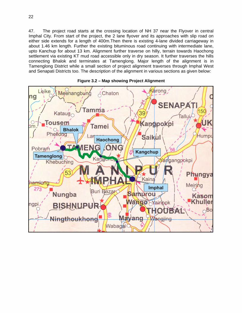
22
47. The project road starts at the crossing location of NH 37 near the Flyover in central Imphal City. From start of the project, the 2 lane flyover and its approaches with slip road on either side extends for a length of 400m.Then there is existing 4-lane divided carriageway in about 1.46 km length. Further the existing bituminous road continuing with intermediate lane, upto Kanchup for about 13 km. Alignment further traverse on hilly, terrain towards Haochong settlement via existing KT mud road accessible only in dry season. It further traverses the hills connecting Bhalok and terminates at Tamenglong. Major length of the alignment is in Tamenglong District while a small section of project alignment traverses through Imphal West and Senapati Districts too. The description of the alignment in various sections as given below:
Figure 3.2 – Map showing Project Alignment
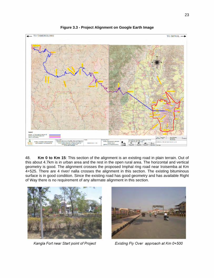
23
Figure 3.3 - Project Alignment on Google Earth Image
48. Km 0 to Km 15: This section of the alignment is an existing road in plain terrain. Out of this about 4.7km is in urban area and the rest in the open rural area. The horizontal and vertical geometry is good. The alignment crosses the proposed Imphal ring road near Iroisemba at Km 4+525. There are 4 river/ nalla crosses the alignment in this section. The existing bituminous surface is in good condition. Since the existing road has good geometry and has available Right of Way there is no requirement of any alternate alignment in this section.
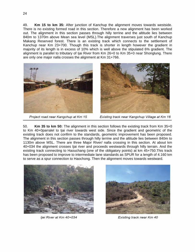
24
49. Km 15 to km 35: After junction of Kanchup the alignment moves towards westside. There is no existing formed road in this section. Therefore a new alignment has been worked out. The alignment in this section passes through hilly terrine and the altitude lies between 840m to 1370m above Mean sea level (MSL).The alignment traverses just south of Kanchup Makang Reserved forest. There is an existing track which connects to the settlement of Kanchup near Km 23+700. Though this track is shorter in length however the gradient in majority of its length is in excess of 10% which is well above the stipulated 6% gradient. The alignment is parallel to tributary of Ijai River from Km 26+0 to Km 35+0 near Shonglung. There are only one major nalla crosses the alignment at Km 31+766.
50. Km 35 to km 50: The alignment in this section follows the existing track from Km 35+0 to Km 40+0parralel to Ijai river towards west side. Since the gradient and geometric of the existing track does not confirm to the standards, geometric improvement has been proposed. The alignment in this section passes through hilly terrine and the altitude lies between 840m to 1130m above MSL. There are three Major River/ nalla crossing in this section. At about km 40+034 the alignment crosses Ijai river and proceeds westwards through hilly terrain. And the existing track connecting to Haouchang (one of the obligatory points) at km 45+750.This track has been proposed to improve to intermediate lane standards as SPUR for a length of 4.160 km to serve as a spur connection to Haochong. Then the alignment moves towards westward.
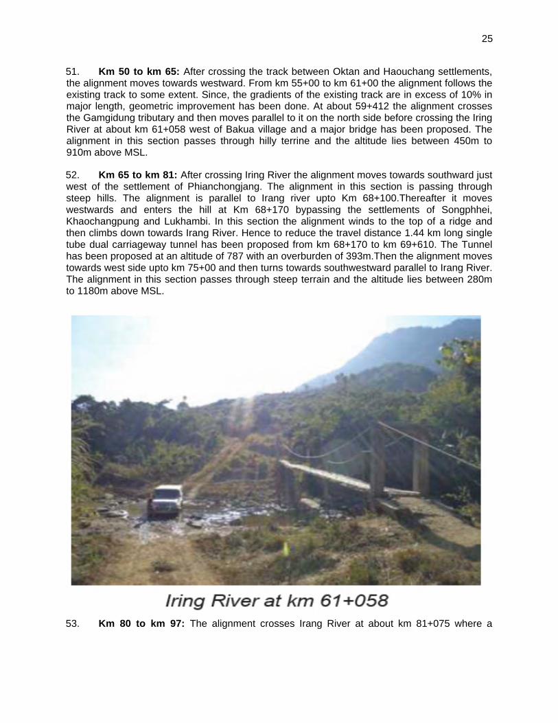
25
51. Km 50 to km 65: After crossing the track between Oktan and Haouchang settlements, the alignment moves towards westward. From km 55+00 to km 61+00 the alignment follows the existing track to some extent. Since, the gradients of the existing track are in excess of 10% in major length, geometric improvement has been done. At about 59+412 the alignment crosses the Gamgidung tributary and then moves parallel to it on the north side before crossing the Iring River at about km 61+058 west of Bakua village and a major bridge has been proposed. The alignment in this section passes through hilly terrine and the altitude lies between 450m to 910m above MSL.
52. Km 65 to km 81: After crossing Iring River the alignment moves towards southward just west of the settlement of Phianchongjang. The alignment in this section is passing through steep hills. The alignment is parallel to Irang river upto Km 68+100.Thereafter it moves westwards and enters the hill at Km 68+170 bypassing the settlements of Songphhei, Khaochangpung and Lukhambi. In this section the alignment winds to the top of a ridge and then climbs down towards Irang River. Hence to reduce the travel distance 1.44 km long single tube dual carriageway tunnel has been proposed from km 68+170 to km 69+610. The Tunnel has been proposed at an altitude of 787 with an overburden of 393m.Then the alignment moves towards west side upto km 75+00 and then turns towards southwestward parallel to Irang River. The alignment in this section passes through steep terrain and the altitude lies between 280m to 1180m above MSL.
53. Km 80 to km 97: The alignment crosses Irang River at about km 81+075 where a
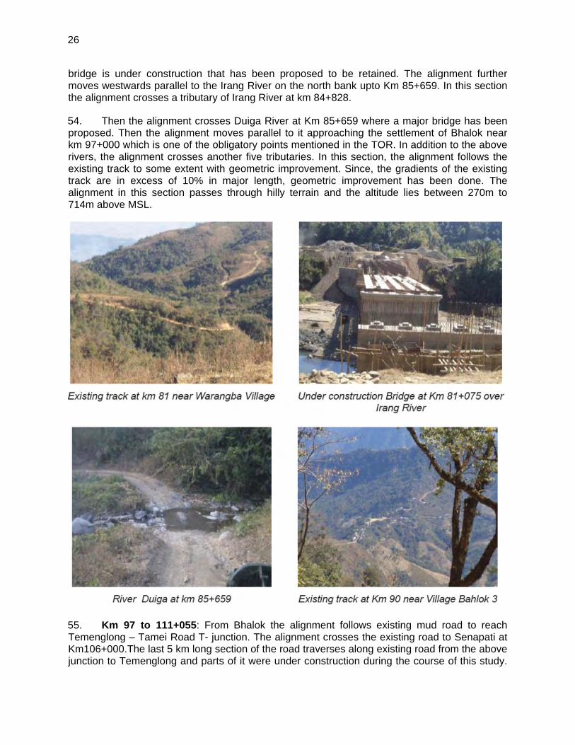
26
bridge is under construction that has been proposed to be retained. The alignment further moves westwards parallel to the Irang River on the north bank upto Km 85+659. In this section the alignment crosses a tributary of Irang River at km 84+828.
54. Then the alignment crosses Duiga River at Km 85+659 where a major bridge has been proposed. Then the alignment moves parallel to it approaching the settlement of Bhalok near km 97+000 which is one of the obligatory points mentioned in the TOR. In addition to the above rivers, the alignment crosses another five tributaries. In this section, the alignment follows the existing track to some extent with geometric improvement. Since, the gradients of the existing track are in excess of 10% in major length, geometric improvement has been done. The alignment in this section passes through hilly terrain and the altitude lies between 270m to 714m above MSL.
55. Km 97 to 111+055: From Bhalok the alignment follows existing mud road to reach Temenglong – Tamei Road T- junction. The alignment crosses the existing road to Senapati at Km106+000.The last 5 km long section of the road traverses along existing road from the above junction to Temenglong and parts of it were under construction during the course of this study.
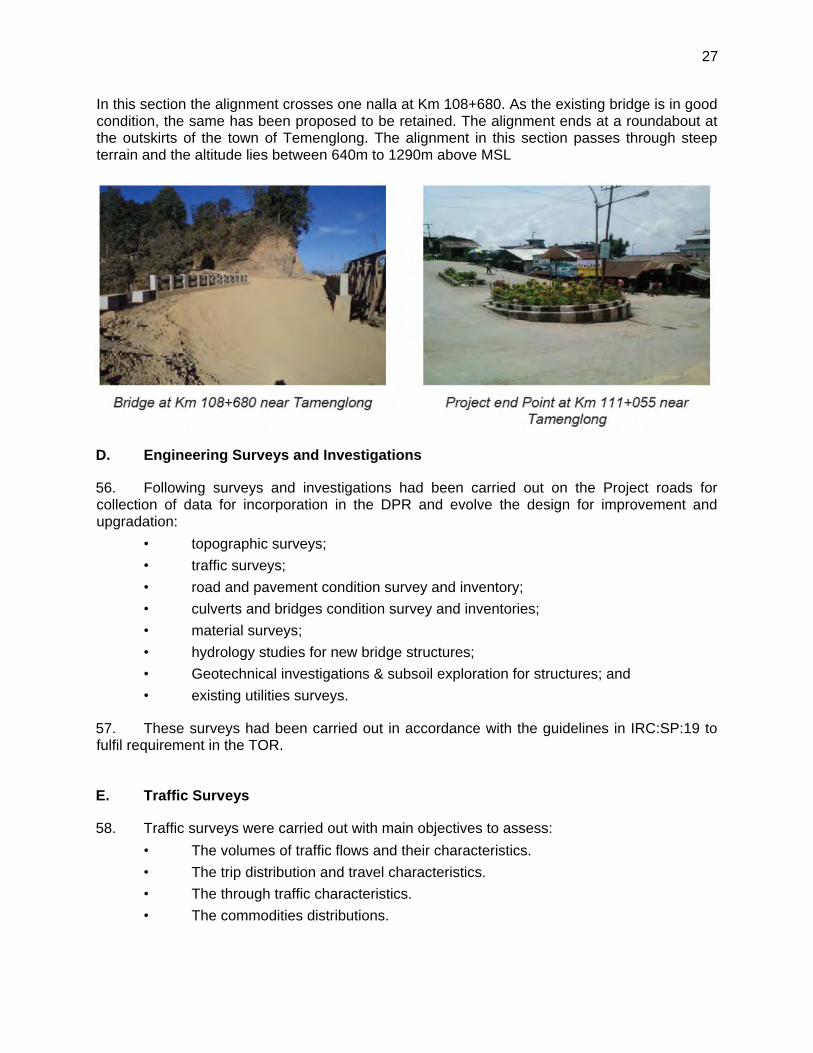
27
In this section the alignment crosses one nalla at Km 108+680. As the existing bridge is in good condition, the same has been proposed to be retained. The alignment ends at a roundabout at the outskirts of the town of Temenglong. The alignment in this section passes through steep terrain and the altitude lies between 640m to 1290m above MSL
D. Engineering Surveys and Investigations
56. Following surveys and investigations had been carried out on the Project roads for collection of data for incorporation in the DPR and evolve the design for improvement and upgradation:
• topographic surveys;
• traffic surveys;
• road and pavement condition survey and inventory;
• culverts and bridges condition survey and inventories;
• material surveys;
• hydrology studies for new bridge structures;
• Geotechnical investigations & subsoil exploration for structures; and
• existing utilities surveys.
57. These surveys had been carried out in accordance with the guidelines in IRC:SP:19 to fulfil requirement in the TOR.
E. Traffic Surveys
58. Traffic surveys were carried out with main objectives to assess:
• The volumes of traffic flows and their characteristics.
• The trip distribution and travel characteristics.
• The through traffic characteristics.
• The commodities distributions.
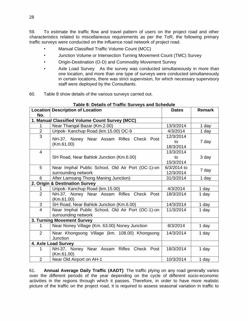
28
59. To estimate the traffic flow and travel pattern of users on the project road and other characteristics related to miscellaneous requirements as per the ToR, the following primary traffic surveys were conducted on the influence road network of project road.
• Manual Classified Traffic Volume Count (MCC)
• Junction Volume or Intersection Turning Movement Count (TMC) Survey
• Origin-Destination (O-D) and Commodity Movement Survey
• Axle Load Survey �As the survey was conducted simultaneously in more than one location, and more than one type of surveys were conducted simultaneously in certain locations, there was strict supervision, for which necessary supervisory staff were deployed by the Consultants.
60. Table 8 show details of the various surveys carried out.
Table 8: Details of Traffic Surveys and Schedule Location
No. Description of Location Dates Remark
1. Manual Classified Volume Count Survey (MCC) 1 Near Thangal Bazar (Km.2.00) 13/3/2014 1 day 2 Uripok- Kanchup Road (km.15.00) OC-9 4/3/2014 1 day 3
NH-37, Noney Near Assam Rifles Check Post (Km.61.00)
12/3/2014 to
18/3/2014 7 day
4 SH Road, Near Bahlok Junction (Km.6.00)
13/3/2014 to
15/3/2014 3 day
5 Near Imphal Public School, Old Air Port (OC-1)-on surrounding network
6/3/2014 to 12/3/2014
7 day
6 After Lamsang Thong Maning Junction) 31/3/2014 1 day 2. Origin & Destination Survey
1 Uripok- Kanchup Road (km.15.00) 4/3/2014 1 day 2 NH-37, Noney Near Assam Rifles Check Post
(Km.61.00) 18/3/2014 1 day
3 SH Road, Near Bahlok Junction (Km.6.00) 14/3/2014 1 day 4 Near Imphal Public School, Old Air Port (OC-1)-on
surrounding network 11/3/2014 1 day
3. Turning Movement Survey 1 Near Noney Village (Km. 63.00) Noney Junction 8/3/2014 1 day
2 Near Khongsong Village (km. 108.00) Khongsong Junction
14/3/2014 1 day
4. Axle Load Survey 1 NH-37, Noney Near Assam Rifles Check Post
(Km.61.00) 18/3/2014 1 day
2 Near Old Airport on AH-1 10/3/2014 1 day
61. Annual Average Daily Traffic (AADT): The traffic plying on any road generally varies over the different periods of the year depending on the cycle of different socio-economic activities in the regions through which it passes. Therefore, in order to have more realistic picture of the traffic on the project road, it is required to assess seasonal variation in traffic to
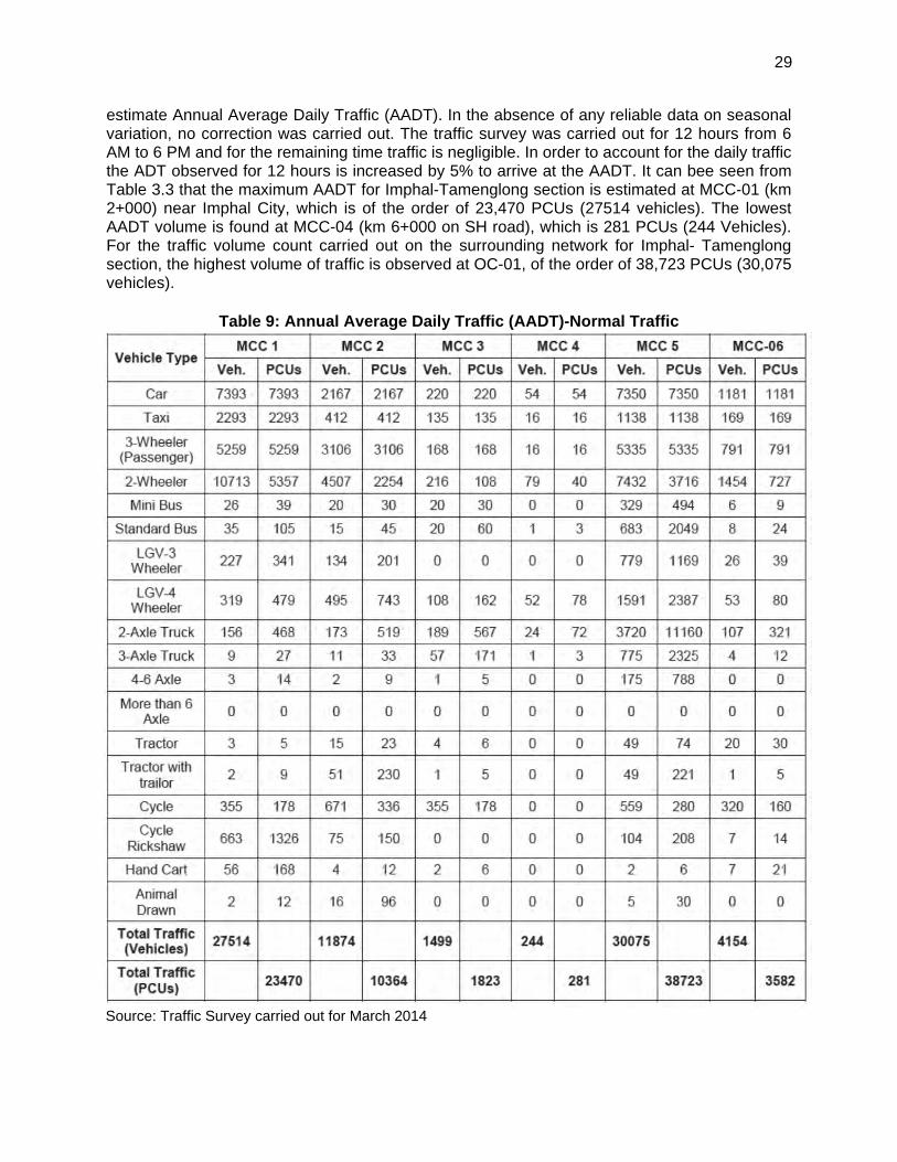
29
estimate Annual Average Daily Traffic (AADT). In the absence of any reliable data on seasonal variation, no correction was carried out. The traffic survey was carried out for 12 hours from 6 AM to 6 PM and for the remaining time traffic is negligible. In order to account for the daily traffic the ADT observed for 12 hours is increased by 5% to arrive at the AADT. It can bee seen from Table 3.3 that the maximum AADT for Imphal-Tamenglong section is estimated at MCC-01 (km 2+000) near Imphal City, which is of the order of 23,470 PCUs (27514 vehicles). The lowest AADT volume is found at MCC-04 (km 6+000 on SH road), which is 281 PCUs (244 Vehicles). For the traffic volume count carried out on the surrounding network for Imphal- Tamenglong section, the highest volume of traffic is observed at OC-01, of the order of 38,723 PCUs (30,075 vehicles).
Table 9: Annual Average Daily Traffic (AADT)-Normal Traffic
Source: Traffic Survey carried out for March 2014
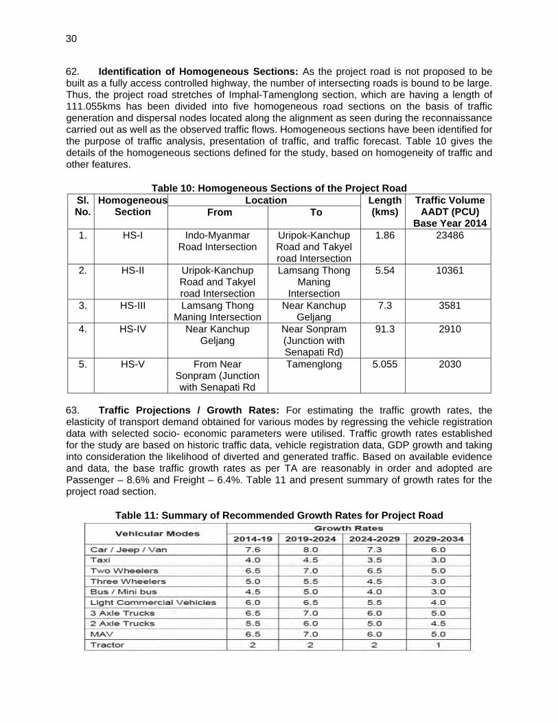
30
62. Identification of Homogeneous Sections: As the project road is not proposed to be built as a fully access controlled highway, the number of intersecting roads is bound to be large. Thus, the project road stretches of Imphal-Tamenglong section, which are having a length of 111.055kms has been divided into five homogeneous road sections on the basis of traffic generation and dispersal nodes located along the alignment as seen during the reconnaissance carried out as well as the observed traffic flows. Homogeneous sections have been identified for the purpose of traffic analysis, presentation of traffic, and traffic forecast. Table 10 gives the details of the homogeneous sections defined for the study, based on homogeneity of traffic and other features.
Table 10: Homogeneous Sections of the Project Road Sl. No.
HomogeneousSection
Location Length (kms)
Traffic Volume AADT (PCU)
Base Year 2014From To
1. HS-I Indo-Myanmar Road Intersection
Uripok-Kanchup Road and Takyel road Intersection
1.86 23486
2. HS-II Uripok-Kanchup Road and Takyel road Intersection
Lamsang Thong Maning
Intersection
5.54 10361
3. HS-III Lamsang Thong Maning Intersection
Near Kanchup Geljang
7.3 3581
4. HS-IV Near Kanchup Geljang
Near Sonpram (Junction with Senapati Rd)
91.3 2910
5. HS-V From Near Sonpram (Junction with Senapati Rd
Tamenglong 5.055 2030
63. Traffic Projections / Growth Rates: For estimating the traffic growth rates, the elasticity of transport demand obtained for various modes by regressing the vehicle registration data with selected socio- economic parameters were utilised. Traffic growth rates established for the study are based on historic traffic data, vehicle registration data, GDP growth and taking into consideration the likelihood of diverted and generated traffic. Based on available evidence and data, the base traffic growth rates as per TA are reasonably in order and adopted are Passenger – 8.6% and Freight – 6.4%. Table 11 and present summary of growth rates for the project road section.
Table 11: Summary of Recommended Growth Rates for Project Road
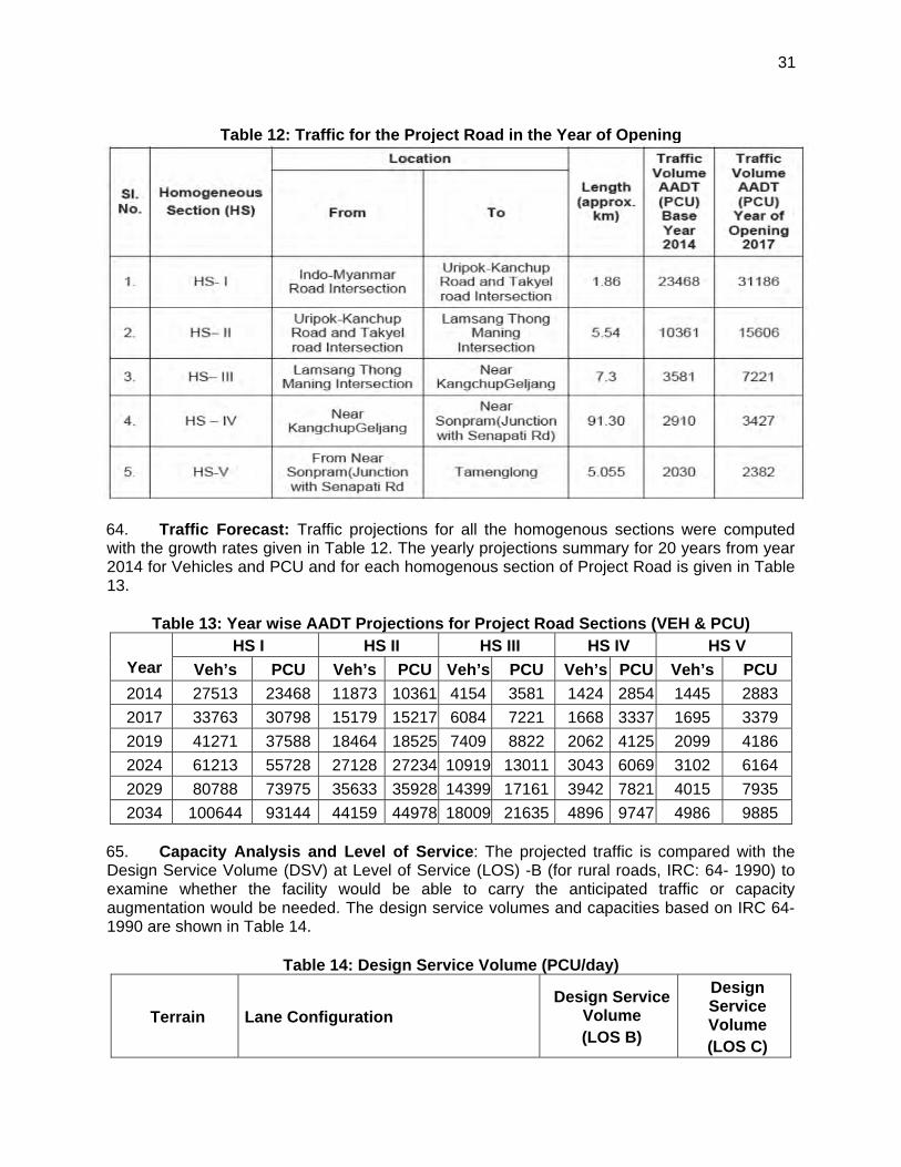
31
Table 12: Traffic for the Project Road in the Year of Opening
64. Traffic Forecast: Traffic projections for all the homogenous sections were computed with the growth rates given in Table 12. The yearly projections summary for 20 years from year 2014 for Vehicles and PCU and for each homogenous section of Project Road is given in Table 13.
Table 13: Year wise AADT Projections for Project Road Sections (VEH & PCU)
Year HS I HS II HS III HS IV HS V
Veh’s PCU Veh’s PCU Veh’s PCU Veh’s PCU Veh’s PCU
2014 27513 23468 11873 10361 4154 3581 1424 2854 1445 2883
2017 33763 30798 15179 15217 6084 7221 1668 3337 1695 3379
2019 41271 37588 18464 18525 7409 8822 2062 4125 2099 4186
2024 61213 55728 27128 27234 10919 13011 3043 6069 3102 6164
2029 80788 73975 35633 35928 14399 17161 3942 7821 4015 7935
2034 100644 93144 44159 44978 18009 21635 4896 9747 4986 9885
65. Capacity Analysis and Level of Service: The projected traffic is compared with the Design Service Volume (DSV) at Level of Service (LOS) -B (for rural roads, IRC: 64- 1990) to examine whether the facility would be able to carry the anticipated traffic or capacity augmentation would be needed. The design service volumes and capacities based on IRC 64-1990 are shown in Table 14.
Table 14: Design Service Volume (PCU/day)
Terrain Lane Configuration Design Service
Volume (LOS B)
Design Service Volume (LOS C)
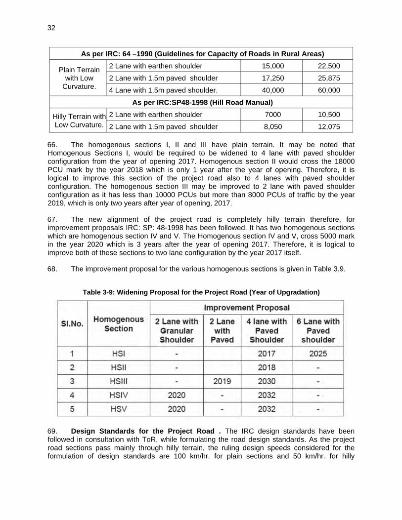
32
As per IRC: 64 –1990 (Guidelines for Capacity of Roads in Rural Areas)
Plain Terrain with Low
Curvature.
2 Lane with earthen shoulder 15,000 22,500
2 Lane with 1.5m paved shoulder 17,250 25,875
4 Lane with 1.5m paved shoulder. 40,000 60,000
As per IRC:SP48-1998 (Hill Road Manual)
Hilly Terrain with Low Curvature.
2 Lane with earthen shoulder 7000 10,500
2 Lane with 1.5m paved shoulder 8,050 12,075
66. The homogenous sections I, II and III have plain terrain. It may be noted that Homogenous Sections I, would be required to be widened to 4 lane with paved shoulder configuration from the year of opening 2017. Homogenous section II would cross the 18000 PCU mark by the year 2018 which is only 1 year after the year of opening. Therefore, it is logical to improve this section of the project road also to 4 lanes with paved shoulder configuration. The homogenous section III may be improved to 2 lane with paved shoulder configuration as it has less than 10000 PCUs but more than 8000 PCUs of traffic by the year 2019, which is only two years after year of opening, 2017.
67. The new alignment of the project road is completely hilly terrain therefore, for improvement proposals IRC: SP: 48-1998 has been followed. It has two homogenous sections which are homogenous section IV and V. The Homogenous section IV and V, cross 5000 mark in the year 2020 which is 3 years after the year of opening 2017. Therefore, it is logical to improve both of these sections to two lane configuration by the year 2017 itself.
68. The improvement proposal for the various homogenous sections is given in Table 3.9.
Table 3-9: Widening Proposal for the Project Road (Year of Upgradation)
69. Design Standards for the Project Road . The IRC design standards have been followed in consultation with ToR, while formulating the road design standards. As the project road sections pass mainly through hilly terrain, the ruling design speeds considered for the formulation of design standards are 100 km/hr. for plain sections and 50 km/hr. for hilly
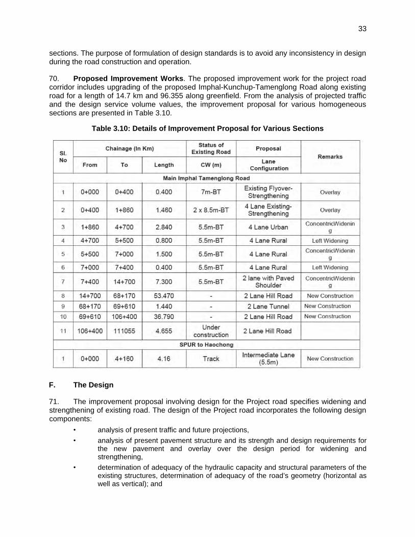
33
sections. The purpose of formulation of design standards is to avoid any inconsistency in design during the road construction and operation.
70. Proposed Improvement Works. The proposed improvement work for the project road corridor includes upgrading of the proposed Imphal-Kunchup-Tamenglong Road along existing road for a length of 14.7 km and 96.355 along greenfield. From the analysis of projected traffic and the design service volume values, the improvement proposal for various homogeneous sections are presented in Table 3.10.
Table 3.10: Details of Improvement Proposal for Various Sections
F. The Design
71. The improvement proposal involving design for the Project road specifies widening and strengthening of existing road. The design of the Project road incorporates the following design components:
• analysis of present traffic and future projections,
• analysis of present pavement structure and its strength and design requirements for the new pavement and overlay over the design period for widening and strengthening,
• determination of adequacy of the hydraulic capacity and structural parameters of the existing structures, determination of adequacy of the road’s geometry (horizontal as well as vertical); and
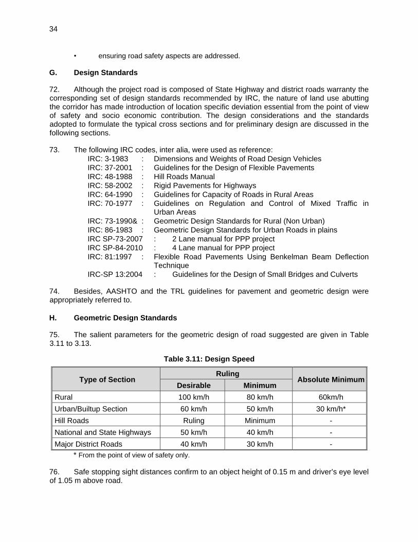
34
• ensuring road safety aspects are addressed.
G. Design Standards
72. Although the project road is composed of State Highway and district roads warranty the corresponding set of design standards recommended by IRC, the nature of land use abutting the corridor has made introduction of location specific deviation essential from the point of view of safety and socio economic contribution. The design considerations and the standards adopted to formulate the typical cross sections and for preliminary design are discussed in the following sections.
73. The following IRC codes, inter alia, were used as reference: IRC: 3-1983 : Dimensions and Weights of Road Design Vehicles IRC: 37-2001 : Guidelines for the Design of Flexible Pavements IRC: 48-1988 : Hill Roads Manual IRC: 58-2002 : Rigid Pavements for Highways IRC: 64-1990 : Guidelines for Capacity of Roads in Rural Areas IRC: 70-1977 : Guidelines on Regulation and Control of Mixed Traffic in Urban Areas IRC: 73-1990& : Geometric Design Standards for Rural (Non Urban) IRC: 86-1983 : Geometric Design Standards for Urban Roads in plains IRC SP-73-2007 : 2 Lane manual for PPP project IRC SP-84-2010 : 4 Lane manual for PPP project IRC: 81:1997 : Flexible Road Pavements Using Benkelman Beam Deflection Technique IRC-SP 13:2004 : Guidelines for the Design of Small Bridges and Culverts
74. Besides, AASHTO and the TRL guidelines for pavement and geometric design were appropriately referred to. H. Geometric Design Standards
75. The salient parameters for the geometric design of road suggested are given in Table 3.11 to 3.13.
Table 3.11: Design Speed
Type of Section Ruling
Absolute MinimumDesirable Minimum
Rural 100 km/h 80 km/h 60km/h
Urban/Builtup Section 60 km/h 50 km/h 30 km/h*
Hill Roads Ruling Minimum -
National and State Highways 50 km/h 40 km/h -
Major District Roads 40 km/h 30 km/h -
* From the point of view of safety only.
76. Safe stopping sight distances confirm to an object height of 0.15 m and driver’s eye level of 1.05 m above road.
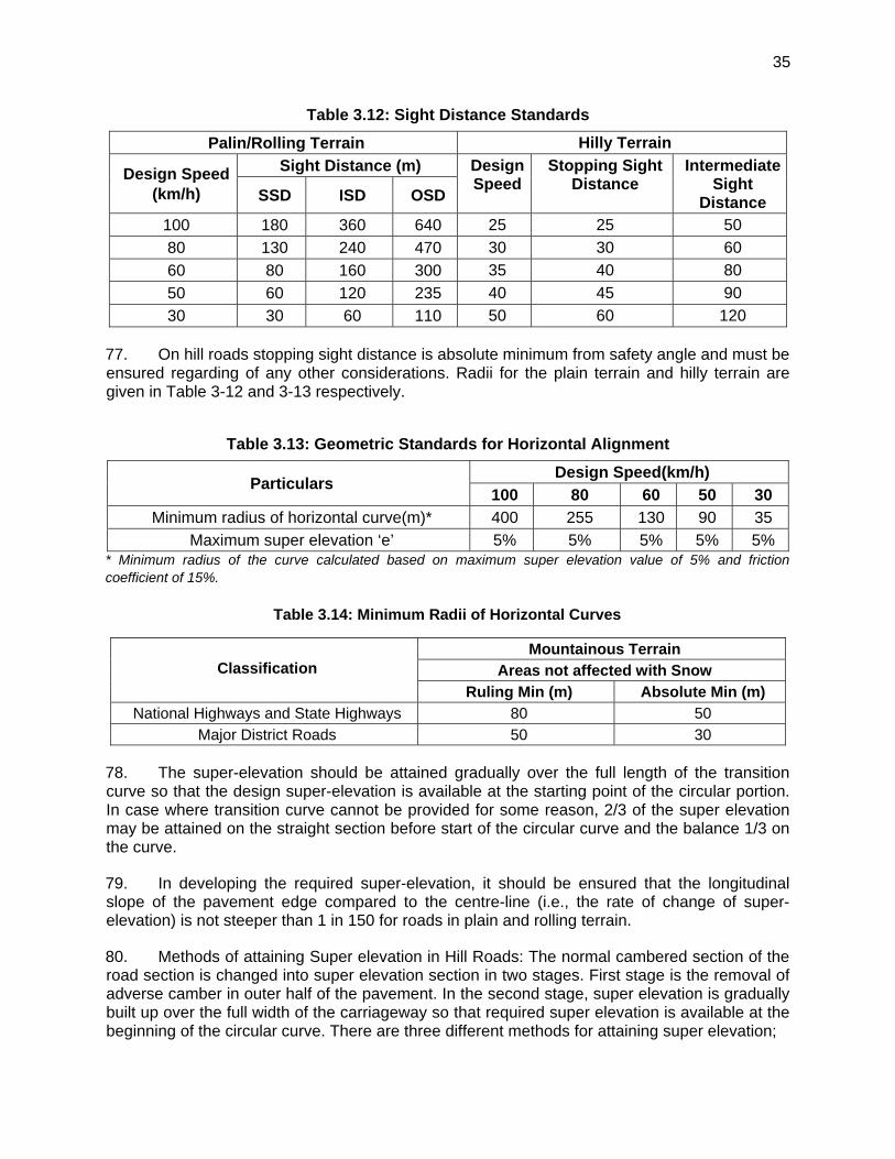
35
Table 3.12: Sight Distance Standards
Palin/Rolling Terrain Hilly Terrain
Design Speed (km/h)
Sight Distance (m) Design Speed
Stopping Sight Distance
Intermediate Sight
Distance SSD ISD OSD
100 180 360 640 25 25 50
80 130 240 470 30 30 60
60 80 160 300 35 40 80
50 60 120 235 40 45 90
30 30 60 110 50 60 120
77. On hill roads stopping sight distance is absolute minimum from safety angle and must be ensured regarding of any other considerations. Radii for the plain terrain and hilly terrain are given in Table 3-12 and 3-13 respectively.
Table 3.13: Geometric Standards for Horizontal Alignment
Particulars Design Speed(km/h)
100 80 60 50 30
Minimum radius of horizontal curve(m)* 400 255 130 90 35
Maximum super elevation ‘e’ 5% 5% 5% 5% 5% * Minimum radius of the curve calculated based on maximum super elevation value of 5% and friction coefficient of 15%.
Table 3.14: Minimum Radii of Horizontal Curves
Classification
Mountainous Terrain Areas not affected with Snow
Ruling Min (m) Absolute Min (m) National Highways and State Highways 80 50
Major District Roads 50 30
78. The super-elevation should be attained gradually over the full length of the transition curve so that the design super-elevation is available at the starting point of the circular portion. In case where transition curve cannot be provided for some reason, 2/3 of the super elevation may be attained on the straight section before start of the circular curve and the balance 1/3 on the curve.
79. In developing the required super-elevation, it should be ensured that the longitudinal slope of the pavement edge compared to the centre-line (i.e., the rate of change of super-elevation) is not steeper than 1 in 150 for roads in plain and rolling terrain.
80. Methods of attaining Super elevation in Hill Roads: The normal cambered section of the road section is changed into super elevation section in two stages. First stage is the removal of adverse camber in outer half of the pavement. In the second stage, super elevation is gradually built up over the full width of the carriageway so that required super elevation is available at the beginning of the circular curve. There are three different methods for attaining super elevation;
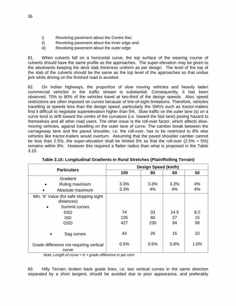
36
i) Revolving pavement about the Centre line; ii) Revolving pavement about the inner edge and; iii) Revolving pavement about the outer edge
81. When culverts fall on a horizontal curve, the top surface of the wearing course of culverts should have the same profile as the approaches. The super-elevation may be given to the abutments keeping the deck slab thickness uniform as per design. The level of the top of the slab of the culverts should be the same as the top level of the approaches so that undue jerk while driving on the finished road is avoided.
82. On Indian highways, the proportion of slow moving vehicles and heavily laden commercial vehicles in the traffic stream is substantial. Consequently, it has been observed, 70% to 80% of the vehicles travel at two-third of the design speeds. Also, speed restrictions are often imposed on curves because of line-of-sight limitations. Therefore, vehicles travelling at speeds less than the design speed, particularly the SMVs such as tractor-trailers find it difficult to negotiate superelevation higher than 5%. Slow traffic on the outer lane (s) on a curve tend to drift toward the centre of the curvature (i.e. toward the fast lane) posing hazard to themselves and all other road users. The other issue is the roll-over factor, which affects slow-moving vehicles, against travelling on the outer lane of curve. The camber break between the carriageway lane and the paved shoulder, i.e. the roll-over, has to be restricted to 8% else vehicles like tractor-trailers would overturn. Assuming that the paved shoulder camber cannot be less than 2.5%, the super-elevation shall be limited 5% so that the roll-over (2.5% + 5%) remains within 8%. However this required a flatter radius than what is proposed in the Table 3.15.
Table 3.15: Longitudinal Gradients in Rural Stretches (Plain/Rolling Terrain)
Particulars Design Speed (km/h)
100 80 60 50 Gradient
Ruling maximum Absolute maximum
3.3% 3.3%
3.3% 4%
3.3% 4%
4% 4%
Min. 'K' Value (for safe stopping sight distances)
Summit curves SSD ISD OSD
� Sag curves
Grade difference not requiring vertical
curve
74 135 427
43
0.5%
33 60
230
26
0.6%
14.5 27 94
15
0.8%
8.2 15 58
10
1.0%
Note: Length of curve = K × grade difference in per cent
83. Hilly Terrain: broken back grade lines, i.e. two vertical curves in the same direction separated by a short tangent, should be avoided due to poor appearance, and preferably
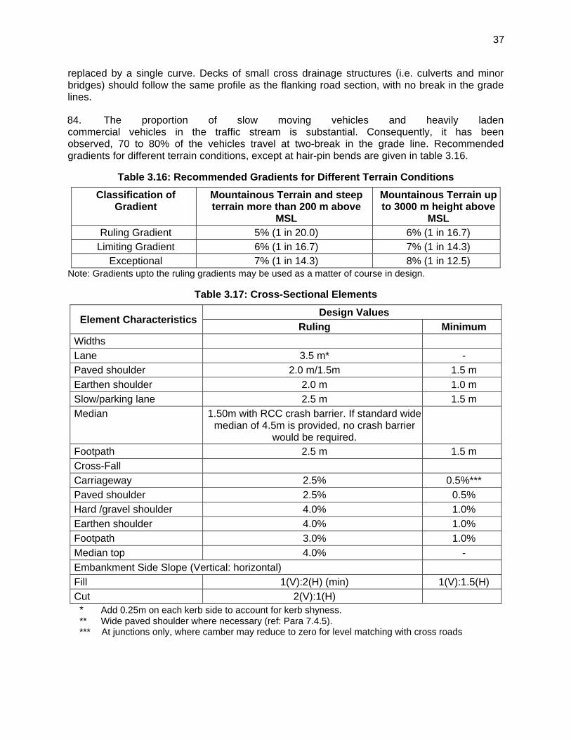
37
replaced by a single curve. Decks of small cross drainage structures (i.e. culverts and minor bridges) should follow the same profile as the flanking road section, with no break in the grade lines.
84. The proportion of slow moving vehicles and heavily laden commercial vehicles in the traffic stream is substantial. Consequently, it has been observed, 70 to 80% of the vehicles travel at two-break in the grade line. Recommended gradients for different terrain conditions, except at hair-pin bends are given in table 3.16.
Table 3.16: Recommended Gradients for Different Terrain Conditions
Classification of Gradient
Mountainous Terrain and steep terrain more than 200 m above
MSL
Mountainous Terrain up to 3000 m height above
MSL Ruling Gradient 5% (1 in 20.0) 6% (1 in 16.7)
Limiting Gradient 6% (1 in 16.7) 7% (1 in 14.3) Exceptional 7% (1 in 14.3) 8% (1 in 12.5)
Note: Gradients upto the ruling gradients may be used as a matter of course in design.
Table 3.17: Cross-Sectional Elements
Element Characteristics Design Values
Ruling Minimum Widths
Lane 3.5 m* -
Paved shoulder 2.0 m/1.5m 1.5 m
Earthen shoulder 2.0 m 1.0 m
Slow/parking lane 2.5 m 1.5 m
Median 1.50m with RCC crash barrier. If standard wide median of 4.5m is provided, no crash barrier
would be required.
Footpath 2.5 m 1.5 m
Cross-Fall
Carriageway 2.5% 0.5%***
Paved shoulder 2.5% 0.5%
Hard /gravel shoulder 4.0% 1.0%
Earthen shoulder 4.0% 1.0%
Footpath 3.0% 1.0%
Median top 4.0% -
Embankment Side Slope (Vertical: horizontal)
Fill 1(V):2(H) (min) 1(V):1.5(H)
Cut 2(V):1(H) * Add 0.25m on each kerb side to account for kerb shyness. ** Wide paved shoulder where necessary (ref: Para 7.4.5). *** At junctions only, where camber may reduce to zero for level matching with cross roads
38
I. Widening Options
85. The widening scheme proposed for this project is given in Table 3.10.
J. Typical Cross-sections
86. Based on the traffic estimates, capacity and the proposed Right of Way (ROW) various typical cross-sections have been worked out for the Imphal Tamenglong road. These are described as given below:
TCS 1: (2 Lane Fly over with slip road) 2 lane carriageway existing Fly over of 7.5m width carriageway with 9.0m width slip road and 3.0m width drain cum footpath on both sides. This section is applicable for the existing Fly over and its approaches on Imphal Tamenglong Road. The existing flyover and its approach is about 0.4 Km length (Km 0+000 to km 0+400) and shall be without any lane addition. Strengthening with bituminous overlay has been proposed.
TCS 2: (4 Lane divided Carriageway-Existing) 4 Lane existing divided carriageway with 7.25 width carriageway and 2.0m wide paved shoulder on both sides separated by 0.75m raised median and both side footpaths cum Drain. This section is applicable for existing road about 1.46 km. Strengthening with bituminous overlay has been proposed for this section.
TCS 3: (4 Lane divided Carriageway - urban) Four lane divided carriageway with 7.25m width either side separated by a 1.5m wide median. It has 2.0m wide paved shoulders and 1.5m wide drain cum footpath on either side. The proposed ROW is 30m. This cross-section is applicable for widening of existing intermediate lane for a length of 2.84 km.
TCS 4: (4 Lane divided Carriageway -rural) Four lane divided carriageway with 7.25m width either side separated by a 1.5m wide median. It has 2.0m wide paved shoulders and 1.0m wide earthen Shoulder on either side. The proposed ROW is 30m. This cross-section is applicable for widening of existing intermediate lane for a length of 2.7 km.
TCS 5: (2 Lane with Paved Shoulder) Two lane 7.0m wide carriageway with 1.5m paved and 1.0m earthen shoulders either side. There will be earthen drain of base width 0.6m either side. The proposed ROW is 30m. This cross-section is applicable for widening of existing intermediate lane for a length of 7.3 km.
TCS 6: (2 Lane in Box cut-Hill section) Two lane 7.0m wide carriageway with 0.9m wide earthen shoulder and unlined drain on either side. This cross-section is applicable in the hill section involving hill cutting on both sides. The applicable length shall be as per the design of vertical profile to be done based on the topographic survey.
TCS 7: (2 Lane with cut/Fill-Hill section) Two lane 7.0m wide carriageway with 0.9m wide earthen shoulder on either side and unlined drain on hill side. This cross-section is applicable in the hill section involving hill cutting on one side and filling on the valley side with provision of breast wall / Retaining wall. The applicable length shall be as per the design of vertical profile to be done based on the topographic survey.
TCS 8: (2 Lane with Fill-Hill section) Two lane 7.0m wide carriageway with 0.9m wide earthen shoulder on either side and unlined drain on hill side. This cross-section is applicable in the hill section involving fill in both sides with provision of

39
breast wall / Retaining wall. The applicable length shall be as per the design of vertical profile to be done based on the topographic survey.
TCS 9: (2 lane Tunnel) Two lane standard single tube bi-directional tunnel cross section with both side footpaths cum walkway. This cross-section is applicable for a length of 1.44 km (from Km 68+170 to Km 69+610 near Songphei).
The Typical cross section for SPUR to Haouchang is same as above for hill road in cutting/filling with carriageway width of 5.5m.
87. Figures 3.4 to 3.12 show some of the typical cross-sections considered as strategies in this study.
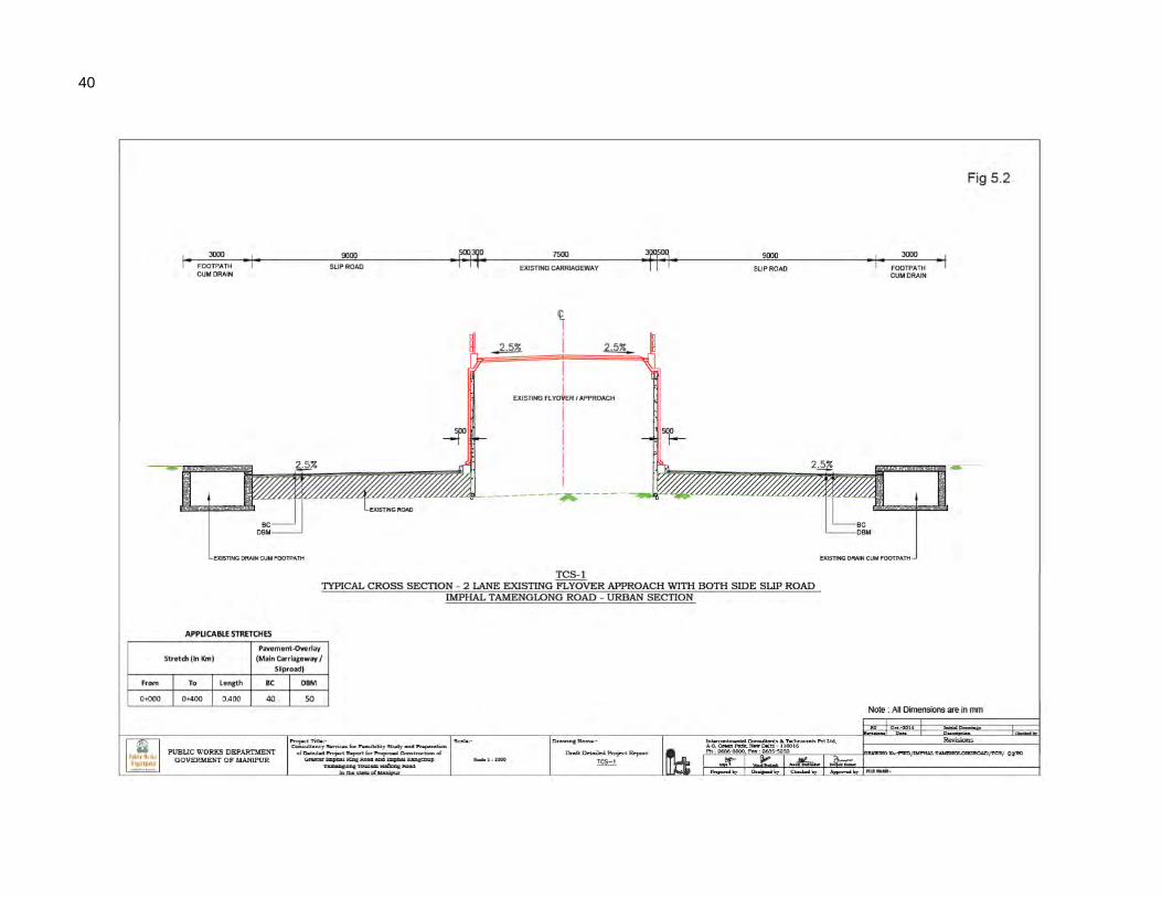
40
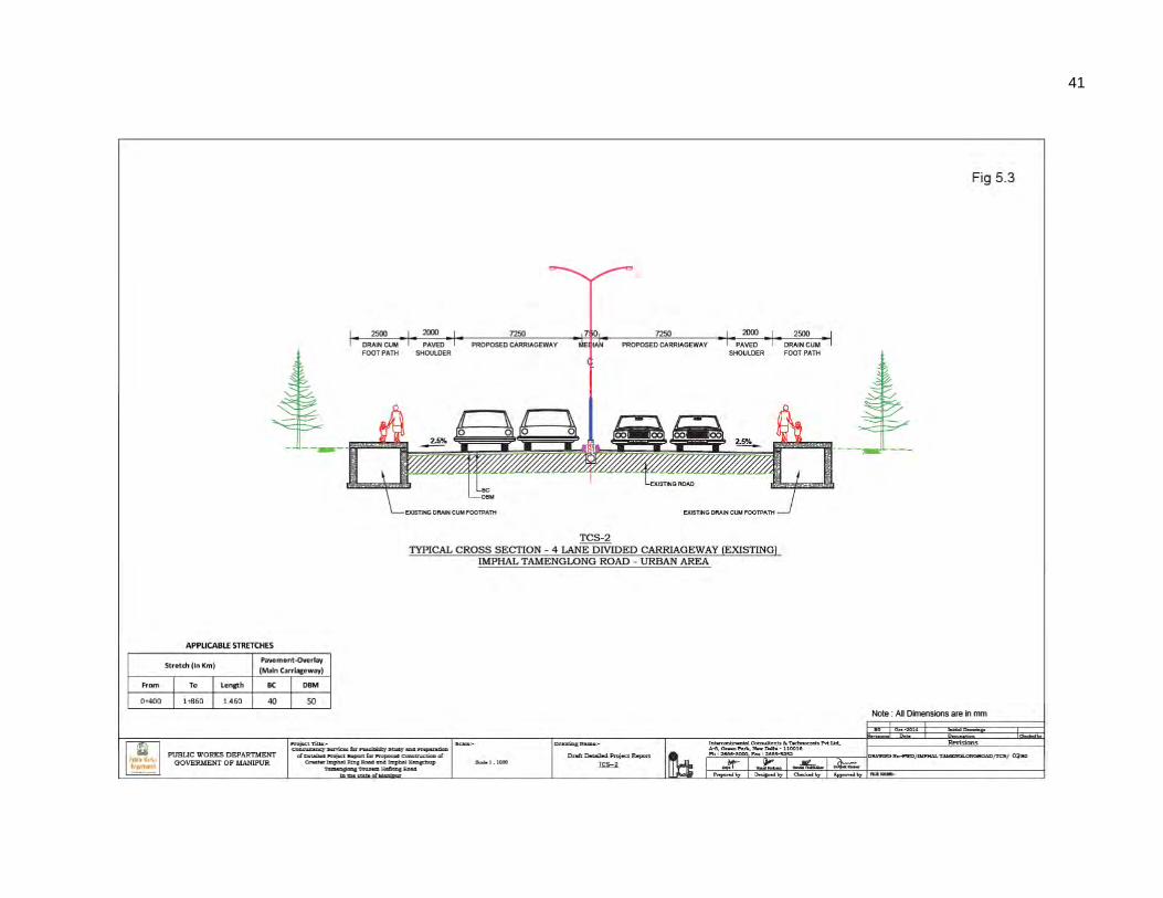
41
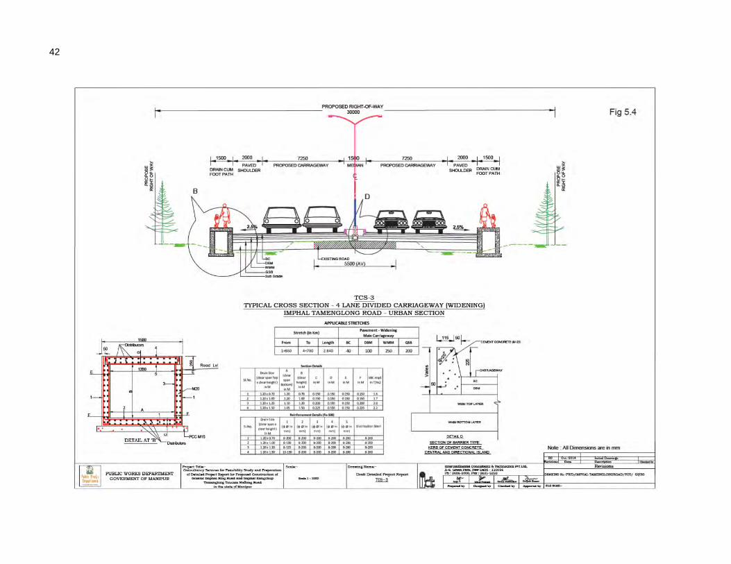
42
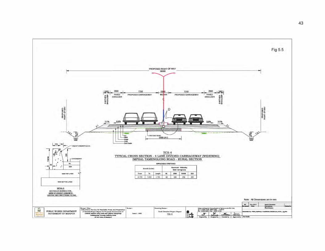
43
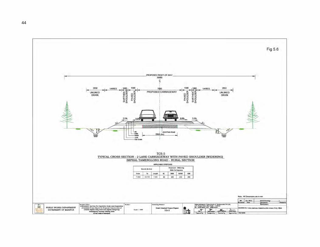
44
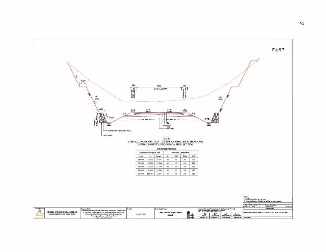
45
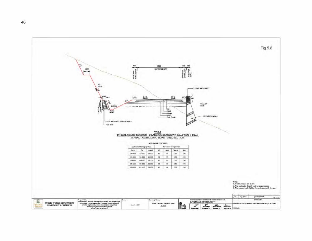
46
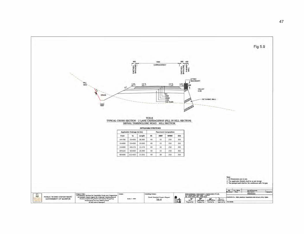
47
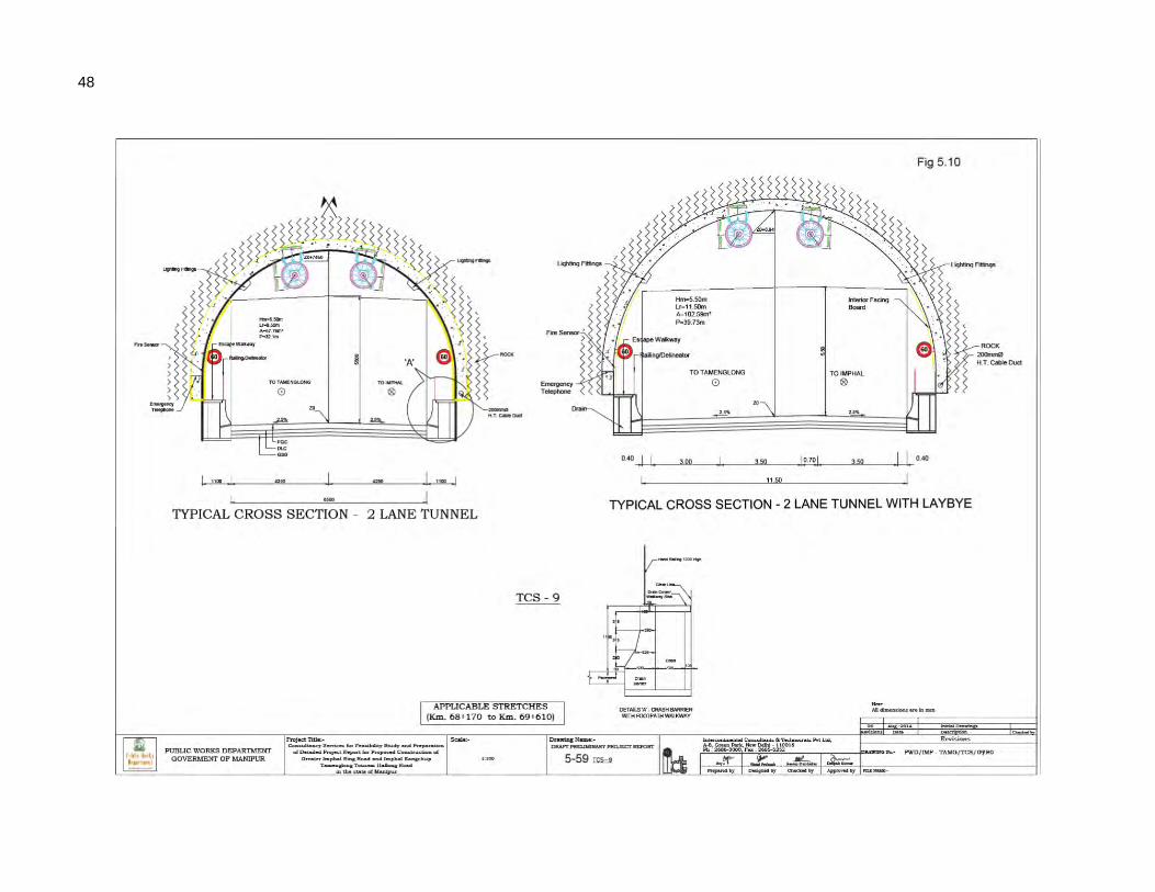
48
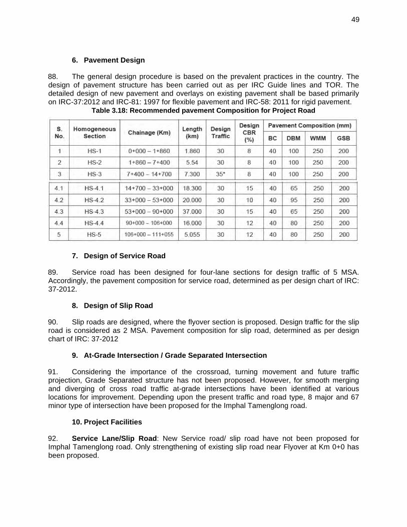
49
6. Pavement Design
88. The general design procedure is based on the prevalent practices in the country. The design of pavement structure has been carried out as per IRC Guide lines and TOR. The detailed design of new pavement and overlays on existing pavement shall be based primarily on IRC-37:2012 and IRC-81: 1997 for flexible pavement and IRC-58: 2011 for rigid pavement.
Table 3.18: Recommended pavement Composition for Project Road
7. Design of Service Road
89. Service road has been designed for four-lane sections for design traffic of 5 MSA. Accordingly, the pavement composition for service road, determined as per design chart of IRC: 37-2012.
8. Design of Slip Road
90. Slip roads are designed, where the flyover section is proposed. Design traffic for the slip road is considered as 2 MSA. Pavement composition for slip road, determined as per design chart of IRC: 37-2012
9. At-Grade Intersection / Grade Separated Intersection
91. Considering the importance of the crossroad, turning movement and future traffic projection, Grade Separated structure has not been proposed. However, for smooth merging and diverging of cross road traffic at-grade intersections have been identified at various locations for improvement. Depending upon the present traffic and road type, 8 major and 67 minor type of intersection have been proposed for the Imphal Tamenglong road.
10. Project Facilities
92. Service Lane/Slip Road: New Service road/ slip road have not been proposed for Imphal Tamenglong road. Only strengthening of existing slip road near Flyover at Km 0+0 has been proposed.
50
93. Footpath: At start of the project, the proposed road passes congested market area. Considering the safety of the pedestrian along the project road, 1.5m width Drain cum footpath has been proposed on either side for a length of 2.84Km.The existing drain cum footpath from Km 0+0 to Km 1+860 has been proposed to be repaired.
94. Median and Median Opening: Due to land constraint 1.5m width of raised median with Kerb has been proposed in 4 lane Sections to separate the traffic.20m width of median opening has been considered at various location for cross passage.
95. Bus Lay Bye: To address the need of people living along the project road, bus lay bay have been proposed. Depending upon the terrain three types of Bus bay have been proposed along the project road. At 27 locations Bus bays have been proposed. The details are as follows:
96. Truck lay bye: Provision of truck lay bye is not required in Imphal Kanchup Tamenglong Road.
97. Road Signs, Pavement Marking and Lighting: The various considerations made for different safety features included in the DPR. Indian Road Congress (IRC) codes have been followed in proposing and designing road safety features. �At all intersections, shoulder mounted advanced directions signs will be provided. The signs shall be with retro reflective micro prismatic grade conforming to Type XI sheeting of ASTM standards for short, medium and long distance viewing to cater visibility requirement encountered by all road users. All curves shall be properly delineated with single chevrons signs which will be placed on outer edge of the curve, so as to view at least 2-3 chevrons from any given instance of viewing. Absolute speed limit signs and also compulsory “no parking” and “no stoppage” signs also have been proposed at regular interval.
98. Pavement markings will be done for traffic lane line, edge lines and hatching. The marking will be with hot applied thermoplastics materials. The pavement markings will be reinforced with raised RR pavement markers and will be provided for median and shoulder edge longitudinal lines and hatch markings. Highway lightings including high masts will be provided at intersections in order to improve the night time visibility.
11. Proposed Right of Way
99. The existing road from Km 0+0 to Km 1+860 has been proposed for strengthening only. Hence land acquisition has not been proposed for this section. To accommodate, the improvement proposal from Km 1+860 to Km 14+700, the Proposed Right of Way (PROW) has been proposed as 30m in general. As decided the PROW for Hilly section has been kept as 30m in general. But in most of the Hilly section the toe line has been spillover beyond the
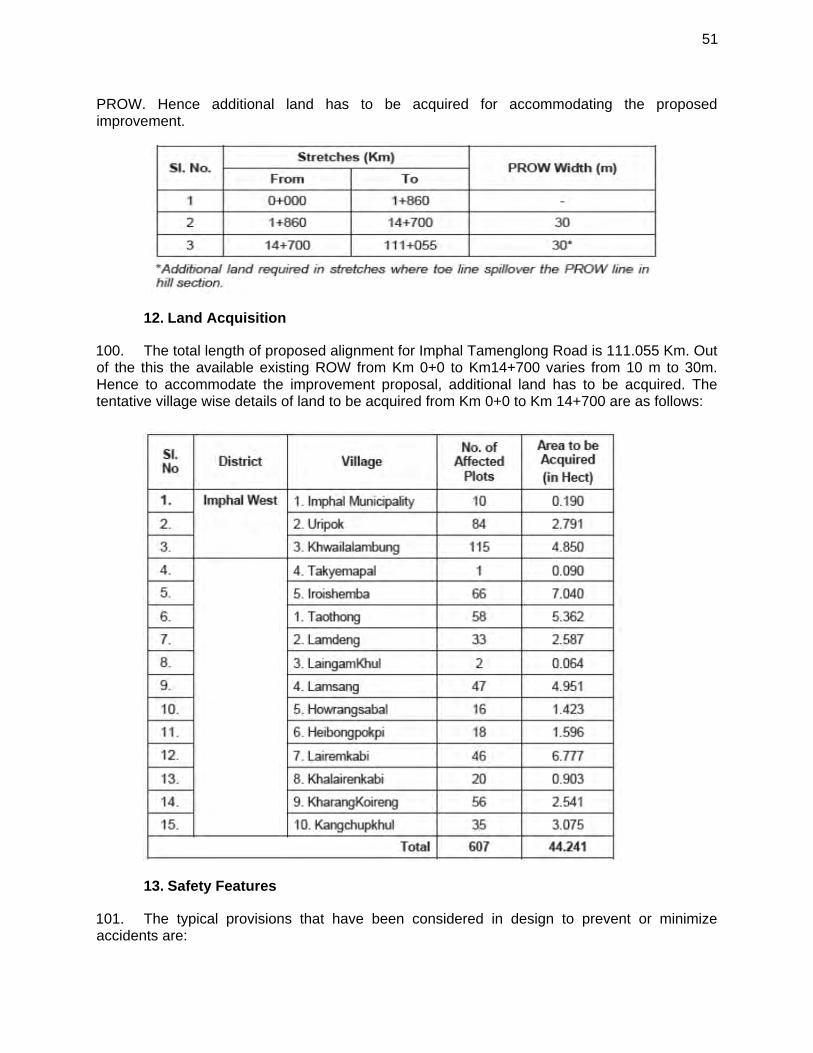
51
PROW. Hence additional land has to be acquired for accommodating the proposed improvement.
12. Land Acquisition
100. The total length of proposed alignment for Imphal Tamenglong Road is 111.055 Km. Out of the this the available existing ROW from Km 0+0 to Km14+700 varies from 10 m to 30m. Hence to accommodate the improvement proposal, additional land has to be acquired. The tentative village wise details of land to be acquired from Km 0+0 to Km 14+700 are as follows:
13. Safety Features
101. The typical provisions that have been considered in design to prevent or minimize accidents are:
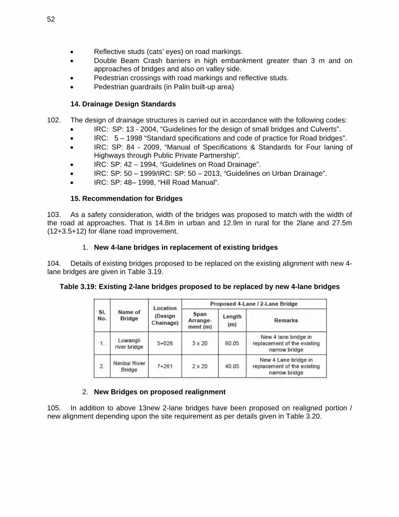
52
Reflective studs (cats’ eyes) on road markings. Double Beam Crash barriers in high embankment greater than 3 m and on
approaches of bridges and also on valley side. Pedestrian crossings with road markings and reflective studs. Pedestrian guardrails (in Palin built-up area)
14. Drainage Design Standards
102. The design of drainage structures is carried out in accordance with the following codes: IRC: SP: 13 - 2004, “Guidelines for the design of small bridges and Culverts”. IRC: 5 – 1998 “Standard specifications and code of practice for Road bridges”. IRC: SP: 84 - 2009, “Manual of Specifications & Standards for Four laning of
Highways through Public Private Partnership”. IRC: SP: 42 – 1994, “Guidelines on Road Drainage”. IRC: SP: 50 – 1999/IRC: SP: 50 – 2013, “Guidelines on Urban Drainage”. IRC: SP: 48– 1998, “Hill Road Manual”.
15. Recommendation for Bridges
103. As a safety consideration, width of the bridges was proposed to match with the width of the road at approaches. That is 14.8m in urban and 12.9m in rural for the 2lane and 27.5m (12+3.5+12) for 4lane road improvement.
New 4-lane bridges in replacement of existing bridges 1.
104. Details of existing bridges proposed to be replaced on the existing alignment with new 4-lane bridges are given in Table 3.19.
Table 3.19: Existing 2-lane bridges proposed to be replaced by new 4-lane bridges
New Bridges on proposed realignment 2.
105. In addition to above 13new 2-lane bridges have been proposed on realigned portion / new alignment depending upon the site requirement as per details given in Table 3.20.
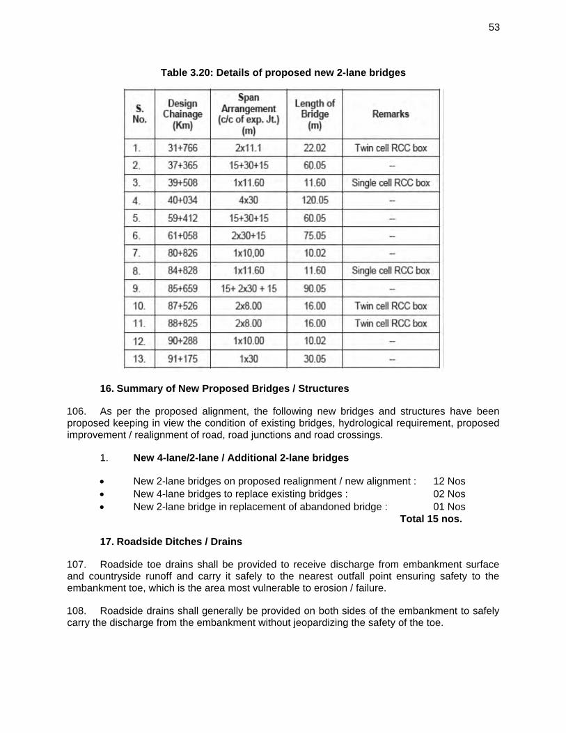
53
Table 3.20: Details of proposed new 2-lane bridges
16. Summary of New Proposed Bridges / Structures
106. As per the proposed alignment, the following new bridges and structures have been proposed keeping in view the condition of existing bridges, hydrological requirement, proposed improvement / realignment of road, road junctions and road crossings.
New 4-lane/2-lane / Additional 2-lane bridges 1.
New 2-lane bridges on proposed realignment / new alignment : 12 Nos New 4-lane bridges to replace existing bridges : 02 Nos New 2-lane bridge in replacement of abandoned bridge : 01 Nos
Total 15 nos.
17. Roadside Ditches / Drains
107. Roadside toe drains shall be provided to receive discharge from embankment surface and countryside runoff and carry it safely to the nearest outfall point ensuring safety to the embankment toe, which is the area most vulnerable to erosion / failure.
108. Roadside drains shall generally be provided on both sides of the embankment to safely carry the discharge from the embankment without jeopardizing the safety of the toe.
54
109. The alignment of the drains shall depend on the topography of the area and the type of drain selected. In plain section U-shaped drains has been proposed on both side. In hilly section u-lined drains has been proposed on hill side.
110. The shape and size of the roadside drains has been decided on the basis of length of embankment being served by the drain up to the nearest outfall point.
111. For stretches passing through urban areas, rectangular covered drains have been recommended for safety reasons.
112. For rural areas, the drains have been open and trapezoidal with 1.5(H):1(V) side slope. As the topography in general is quite flat, optimization of the length of drain, bed width and depth of flow shall be necessary to reduce the top width of the drain (land width required for construction of drain). To reduce the length of drain up to nearest outfall and consequently the section, intermediate balancing culverts shall be provided at suitable locations. These drains may also terminate at local roadside ponds, if feasible. The minimum bed width and depth of flow at starting section shall be 600 mm and 300 mm respectively. The sections shall be gradually increased in terms of bed width and depth of flow up to the outfall point.
113. The section shall be designed to ensure a non-silting / non-scouring velocity in drains.
18. Design of Highway Tunnel
114. To reduce the travel time by 9.11km, the tunnel has been proposed near sangpoi village.
115. Physical Details of the Tunnel: The alignment of the tunnel has been optimized keeping in view the topography and disposition of the hill range across the finalized recommended highway alignment in this stretch. A single tube D-shaped straight tunnel having provision of bidirectional traffic flow has been proposed to be excavated to about 12 m width and 8.5 m height. �Lay byes are also required to be provided at interval of 750 m inside the tunnel. At the locations of the lay byes, the underground excavation of each tube will be of about 15 m width and 10 m height. The proposed Tunnel is planned in latitude of 24°-54’N and in longitude of 93°-37’. The maximum overburden cover along the tunnel alignment is of about 393 ml. Based on the geological set up and the geological features of the tunnel site, geometrics and traffic requirements, the typical functional cross-section of the mined tunnel and cut and cover sections have been designed in accordance with IRC: SP: 91 – 2010 “Guidelines for Road Tunnels” and “Guidelines for Expressway Volume-II Design”.
116. Engineering Characteristics of the Tunnel: In accordance to the traffic demand the proposed road has to be improved to 2 Lane standards. Hence the tunnel has been proposed for single tube dual carriageway. A typical Cross section of the tunnel is given in TCS 9 (Fig 3.12).
55
19. Culverts
117. For improvement of Imphal Kanchup Tamenglong Road, details of culverts to be widened / proposed are as below:
20. Shifting of Utilities
118. Utilities like telephone cable, electrical lines along with water supply lines may be required to shift during widening. A proper scheme of relocating these shall be worked out once the widening schemes are approved. Details of the utilities along the project road are given in the inventory. Strip plan showing existing utilities and relocation plan for the affected utilities due to the widening shall be submitted separately.
21. Road Construction Materials
119. Material Survey for road construction materials for the Project roads, i.e. earth, aggregates, water, bitumen etc. has been carried out in the Project corridor and the indicative lead charts have been prepared.
56
120. Besides, the field in-situ investigations were conducted. The materials samples collected were tested in the laboratory and results data compiled in Material Report of the DPR.
121. The lead involved for the project roads and the investigations are quite representative, but more extensive investigation shall need to be conducted by the contractors at the time of construction, for earth and aggregates available from such sources.
22. Project Cost
122. The cost of civil works including maintenance amounts to about Rs. 11771.61 millions Indian Rupees (US$ 196. million) for 111.055 km Imphal-Tamenglong Road including a spur of Km 4+160 to Hauchong village. These costs are based on 2014 rates as per analytical rates. The cost has been indexed for escalation till mid-2014 @ 5% per annum. The maintenance component is based on an average 3% of total cost of Civil Works for 5 years. This component shall not be undertaken as part of contract for Civil Works, but to be undertaken separately subsequent to the construction.
23. Construction Packaging and Implementation Schedule
123. It is proposed to carry out construction of the road section under one package with a time period of 36 months. The Project is proposed to be undertaken through International Competitive Bidding (ICB). Currently the project is at bidding stage and scheduled to award contract in the first quarter of 2015. The project is expected to complete in last quarter of 2017.
124. The following key factors in Construction Contract Packaging are considered in making the recommendation on Contract Packaging:
Logical sections for construction, worksite access and earthwork balance Administrative jurisdiction and administrative efficiency Size of contract to attract medium and large size contractors with the required
equipment and capability Time to completion Environmental requirements and constraints to specific segments
24. Project Benefits
125. The implementation of various project items is envisaged to have the following direct benefits:
improved quality of life for the rural population in the project influence: this as a result of better access to markets, health, education and other facilities; and the derived stimulus for local economic activity;
a more efficient and safe road transport system: through reduced travel times, reduced road accidents, reduced vehicle operating and maintenance costs and reduced transportation costs for goods;
the facilitation of tourism; Reduced distance to Guwahati, the commercial hub of the North East, from
Imphal by at least 90 (ninety) Kms as compared to the existing route via Dimapur;
Interstate connectivity to Imphal and Tamenglong Districts; Shortest connectivity for the State to East West Corridor of National Highways
Authority of India, and

57
Connectivity to the Asian Highway network.
58
IV. DESCRIPTION OF THE ENVIRONMENT
A. Introduction
126. In order to assess the impacts of the proposed improvement to the project road, field visits were undertaken by the Consultants to understand environmental profile of the project influence area. This involved field inspections at all the sensitive locations, collection of secondary information for all the environmental components and discussions with the officials, NGO’s and local populace. The profile presented below comprises of the following:
Physical environmental components such as meteorology, geology, topography, soil characteristics, air quality, surface and sub-surface water quality;
Biological environmental components such as aquatic, biotic and marine flora, fauna and mammals, and
Land environment in terms of land use, soil composition. B. Physical Environment
127. Information of various physical parameters was collected from the Guwahati Centre of Indian Meteorological Department, Statistical Department, Gazetteer of Manipur, Forest Department, Department of Environment and other concern Government Departments and discussions with the officials from these agencies.
Meteorological Conditions 1.
128. The state has a subtropical monsoon to temperate climate depending on elevation. Rainfall is relatively abundant and widespread. The rainy season starts in June with the onset of the south-west monsoon and last upto September. Intermittent rains continue even upto October along with the retreat of the monsoon. During the rainy season the rainwater in the hills quickly flow down to the valley and all the rivers and small streams rises to the full brim, frequently flooding its embankments. The cold season last from the month of December to February. During the winter months light rainfall occurs under the influence of the north-east monsoon, March and October are by far the most pleasant months in the year. April and May are not hot season followed by occasional thunder storms.
129. The annual rainfall of Manipur in 2001 was to be 1769 mm as against the normal rainfall of 2000mm. The state has a salubrious climate. The summer months are never oppressive with the average maximum temperature fluctuating from 32C to 35C during April-June, the mercury seldom going beyond 37C. In December-February with the start of the cold winter months the average minimum temperature fall to 6C to 4C.
130. The salient climatic features of the state are as follows: Average Annual Rainfall - 1769 mm Concentration of precipitation - June to October Humidity - 79 to 96% Cloudiness - Heavily clouded Wind - Generally light except rainy season Temperature - Summer 32C to 35C
Winter 6C to 4C
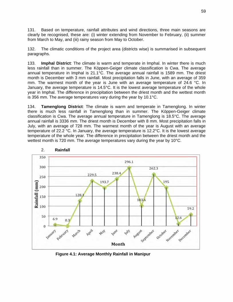
59
131. Based on temperature, rainfall attributes and wind directions, three main seasons are clearly be recognised, these are: (i) winter extending from November to February, (ii) summer from March to May, and (iii) rainy season from May to October.
132. The climatic conditions of the project area (districts wise) is summarised in subsequent paragraphs.
133. Imphal District: The climate is warm and temperate in Imphal. In winter there is much less rainfall than in summer. The Köppen-Geiger climate classification is Cwa. The average annual temperature in Imphal is 21.1°C. The average annual rainfall is 1589 mm. The driest month is December with 3 mm rainfall. Most precipitation falls in June, with an average of 359 mm. The warmest month of the year is June with an average temperature of 24.6 °C. In January, the average temperature is 14.5°C. It is the lowest average temperature of the whole year in Imphal. The difference in precipitation between the driest month and the wettest month is 356 mm. The average temperatures vary during the year by 10.1°C.
134. Tamenglong District: The climate is warm and temperate in Tamenglong. In winter there is much less rainfall in Tamenglong than in summer. The Köppen-Geiger climate classification is Cwa. The average annual temperature in Tamenglong is 18.5°C. The average annual rainfall is 3336 mm. The driest month is December with 8 mm. Most precipitation falls in July, with an average of 728 mm. The warmest month of the year is August with an average temperature of 22.2 °C. In January, the average temperature is 12.2°C. It is the lowest average temperature of the whole year. The difference in precipitation between the driest month and the wettest month is 720 mm. The average temperatures vary during the year by 10°C.
Rainfall 2.
Figure 4.1: Average Monthly Rainfall in Manipur
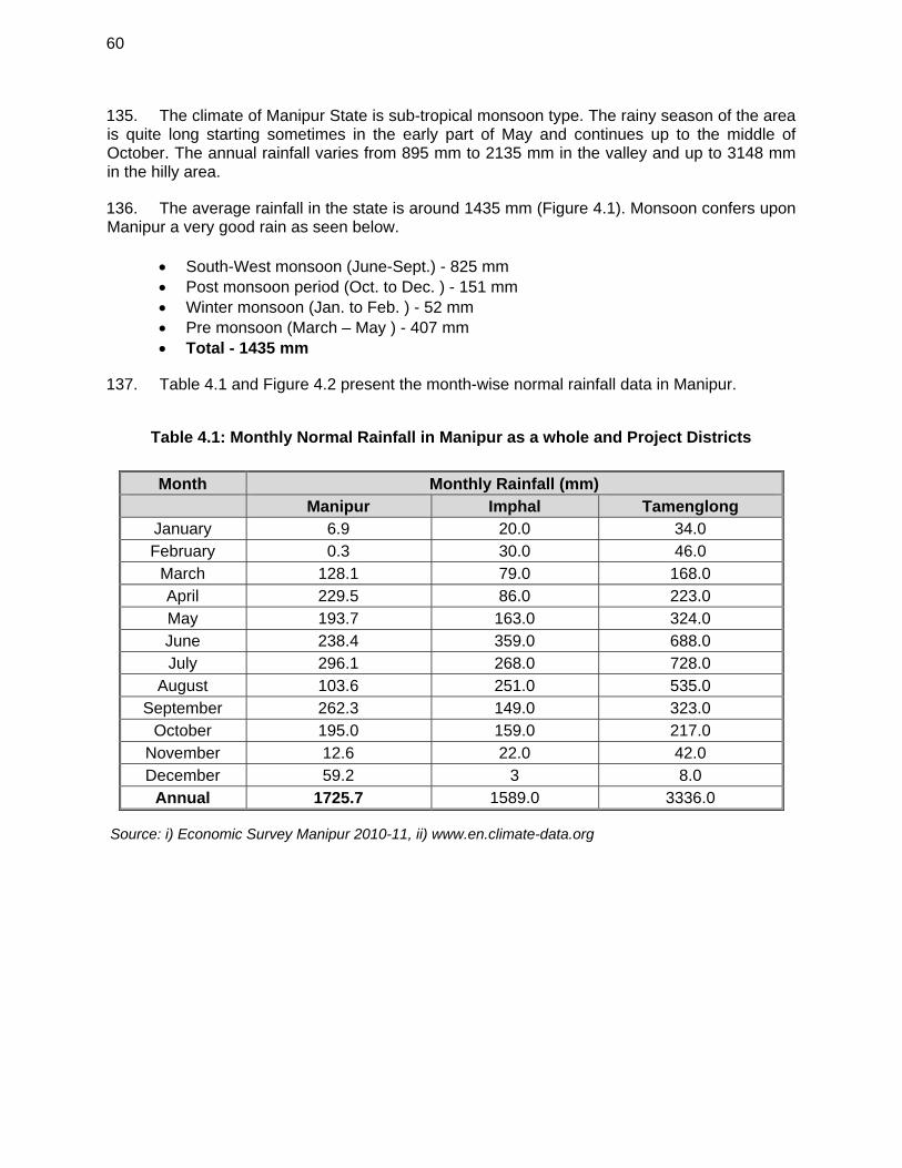
60
135. The climate of Manipur State is sub-tropical monsoon type. The rainy season of the area is quite long starting sometimes in the early part of May and continues up to the middle of October. The annual rainfall varies from 895 mm to 2135 mm in the valley and up to 3148 mm in the hilly area.
136. The average rainfall in the state is around 1435 mm (Figure 4.1). Monsoon confers upon Manipur a very good rain as seen below.
South-West monsoon (June-Sept.) - 825 mm Post monsoon period (Oct. to Dec. ) - 151 mm Winter monsoon (Jan. to Feb. ) - 52 mm Pre monsoon (March – May ) - 407 mm Total - 1435 mm
137. Table 4.1 and Figure 4.2 present the month-wise normal rainfall data in Manipur.
Table 4.1: Monthly Normal Rainfall in Manipur as a whole and Project Districts
Month Monthly Rainfall (mm) Manipur Imphal Tamenglong
January 6.9 20.0 34.0 February 0.3 30.0 46.0
March 128.1 79.0 168.0 April 229.5 86.0 223.0 May 193.7 163.0 324.0 June 238.4 359.0 688.0 July 296.1 268.0 728.0
August 103.6 251.0 535.0 September 262.3 149.0 323.0
October 195.0 159.0 217.0 November 12.6 22.0 42.0 December 59.2 3 8.0
Annual 1725.7 1589.0 3336.0
Source: i) Economic Survey Manipur 2010-11, ii) www.en.climate-data.org
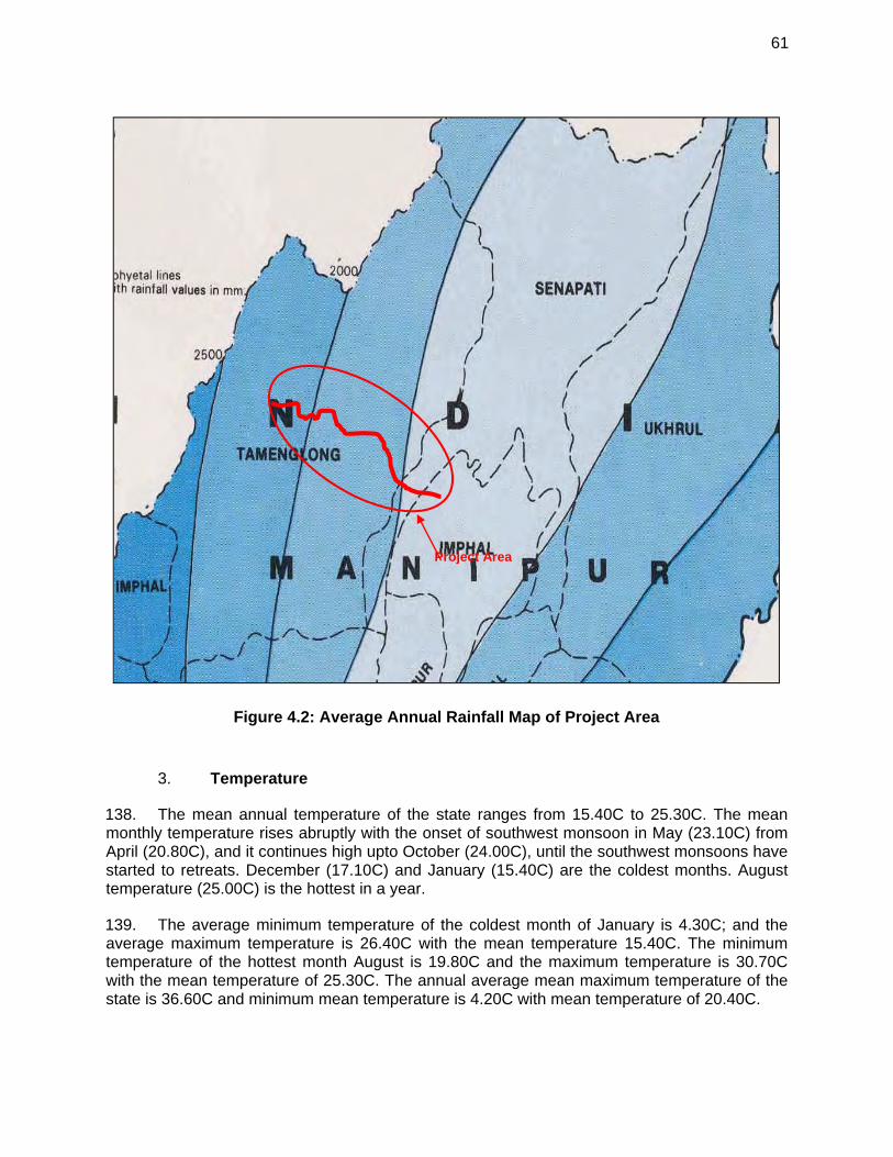
61
Figure 4.2: Average Annual Rainfall Map of Project Area
Temperature 3.
138. The mean annual temperature of the state ranges from 15.40C to 25.30C. The mean monthly temperature rises abruptly with the onset of southwest monsoon in May (23.10C) from April (20.80C), and it continues high upto October (24.00C), until the southwest monsoons have started to retreats. December (17.10C) and January (15.40C) are the coldest months. August temperature (25.00C) is the hottest in a year.
139. The average minimum temperature of the coldest month of January is 4.30C; and the average maximum temperature is 26.40C with the mean temperature 15.40C. The minimum temperature of the hottest month August is 19.80C and the maximum temperature is 30.70C with the mean temperature of 25.30C. The annual average mean maximum temperature of the state is 36.60C and minimum mean temperature is 4.20C with mean temperature of 20.40C.
Project Area
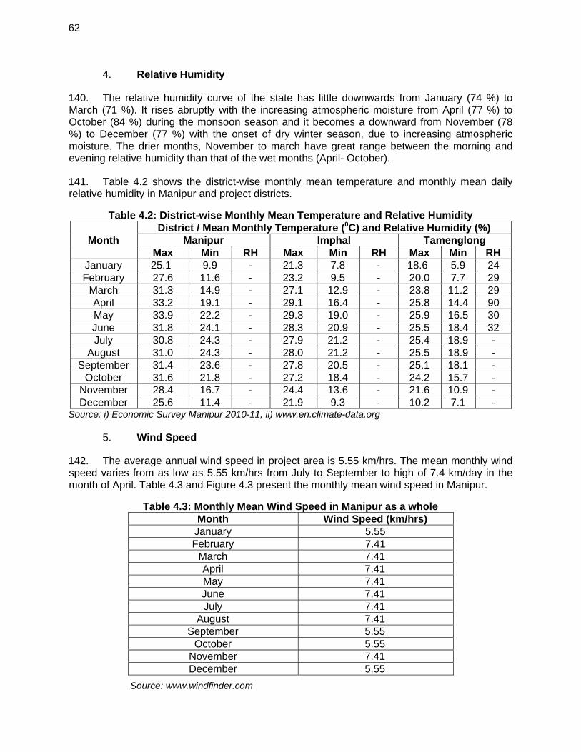
62
Relative Humidity 4.
140. The relative humidity curve of the state has little downwards from January (74 %) to March (71 %). It rises abruptly with the increasing atmospheric moisture from April (77 %) to October (84 %) during the monsoon season and it becomes a downward from November (78 %) to December (77 %) with the onset of dry winter season, due to increasing atmospheric moisture. The drier months, November to march have great range between the morning and evening relative humidity than that of the wet months (April- October).
141. Table 4.2 shows the district-wise monthly mean temperature and monthly mean daily relative humidity in Manipur and project districts.
Table 4.2: District-wise Monthly Mean Temperature and Relative Humidity
Month District / Mean Monthly Temperature (0C) and Relative Humidity (%)
Manipur Imphal Tamenglong Max Min RH Max Min RH Max Min RH
January 25.1 9.9 - 21.3 7.8 - 18.6 5.9 24 February 27.6 11.6 - 23.2 9.5 - 20.0 7.7 29
March 31.3 14.9 - 27.1 12.9 - 23.8 11.2 29 April 33.2 19.1 - 29.1 16.4 - 25.8 14.4 90 May 33.9 22.2 - 29.3 19.0 - 25.9 16.5 30 June 31.8 24.1 - 28.3 20.9 - 25.5 18.4 32 July 30.8 24.3 - 27.9 21.2 - 25.4 18.9 -
August 31.0 24.3 - 28.0 21.2 - 25.5 18.9 - September 31.4 23.6 - 27.8 20.5 - 25.1 18.1 -
October 31.6 21.8 - 27.2 18.4 - 24.2 15.7 - November 28.4 16.7 - 24.4 13.6 - 21.6 10.9 - December 25.6 11.4 - 21.9 9.3 - 10.2 7.1 -
Source: i) Economic Survey Manipur 2010-11, ii) www.en.climate-data.org
Wind Speed 5.
142. The average annual wind speed in project area is 5.55 km/hrs. The mean monthly wind speed varies from as low as 5.55 km/hrs from July to September to high of 7.4 km/day in the month of April. Table 4.3 and Figure 4.3 present the monthly mean wind speed in Manipur.
Table 4.3: Monthly Mean Wind Speed in Manipur as a whole Month Wind Speed (km/hrs)
January 5.55 February 7.41
March 7.41 April 7.41 May 7.41 June 7.41 July 7.41
August 7.41 September 5.55
October 5.55 November 7.41 December 5.55
Source: www.windfinder.com
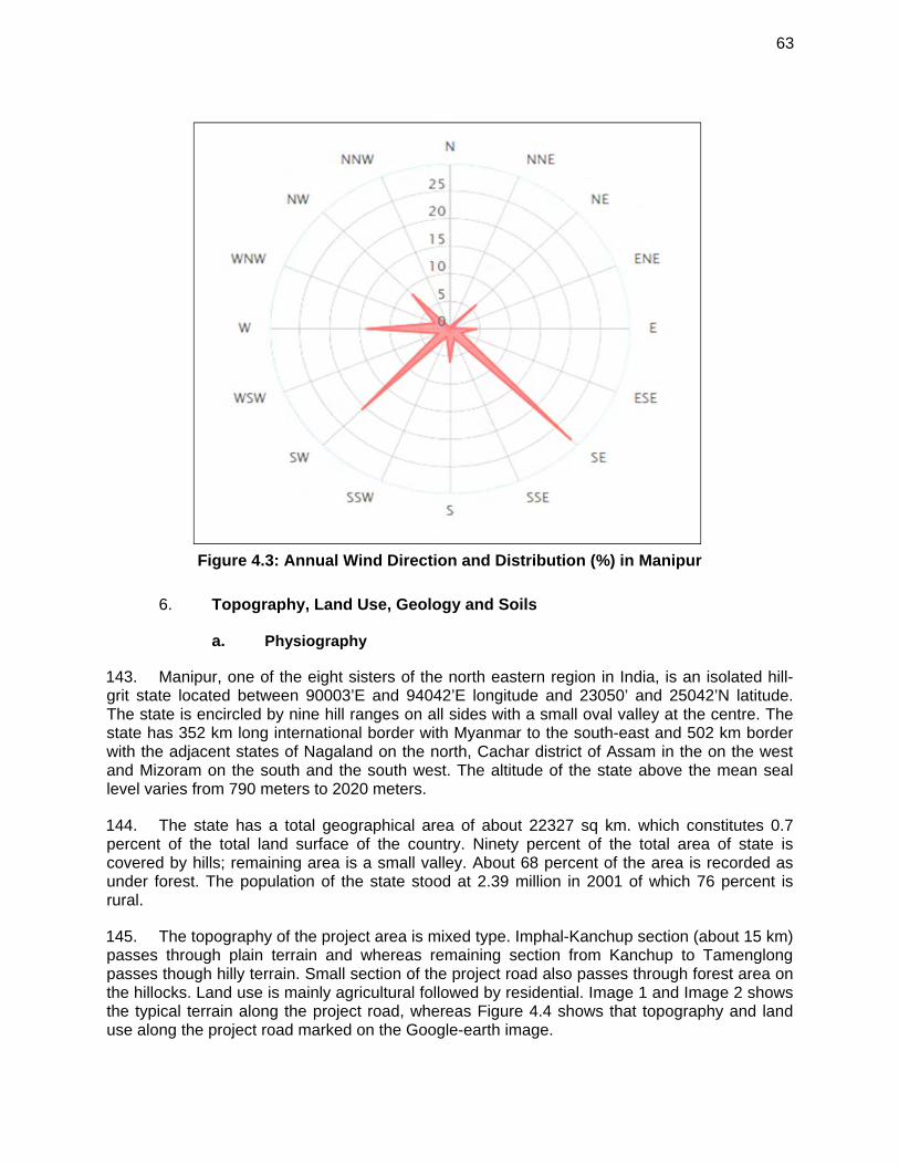
63
Figure 4.3: Annual Wind Direction and Distribution (%) in Manipur
Topography, Land Use, Geology and Soils 6.
a. Physiography
143. Manipur, one of the eight sisters of the north eastern region in India, is an isolated hill-grit state located between 90003’E and 94042’E longitude and 23050’ and 25042’N latitude. The state is encircled by nine hill ranges on all sides with a small oval valley at the centre. The state has 352 km long international border with Myanmar to the south-east and 502 km border with the adjacent states of Nagaland on the north, Cachar district of Assam in the on the west and Mizoram on the south and the south west. The altitude of the state above the mean seal level varies from 790 meters to 2020 meters.
144. The state has a total geographical area of about 22327 sq km. which constitutes 0.7 percent of the total land surface of the country. Ninety percent of the total area of state is covered by hills; remaining area is a small valley. About 68 percent of the area is recorded as under forest. The population of the state stood at 2.39 million in 2001 of which 76 percent is rural.
145. The topography of the project area is mixed type. Imphal-Kanchup section (about 15 km) passes through plain terrain and whereas remaining section from Kanchup to Tamenglong passes though hilly terrain. Small section of the project road also passes through forest area on the hillocks. Land use is mainly agricultural followed by residential. Image 1 and Image 2 shows the typical terrain along the project road, whereas Figure 4.4 shows that topography and land use along the project road marked on the Google-earth image.
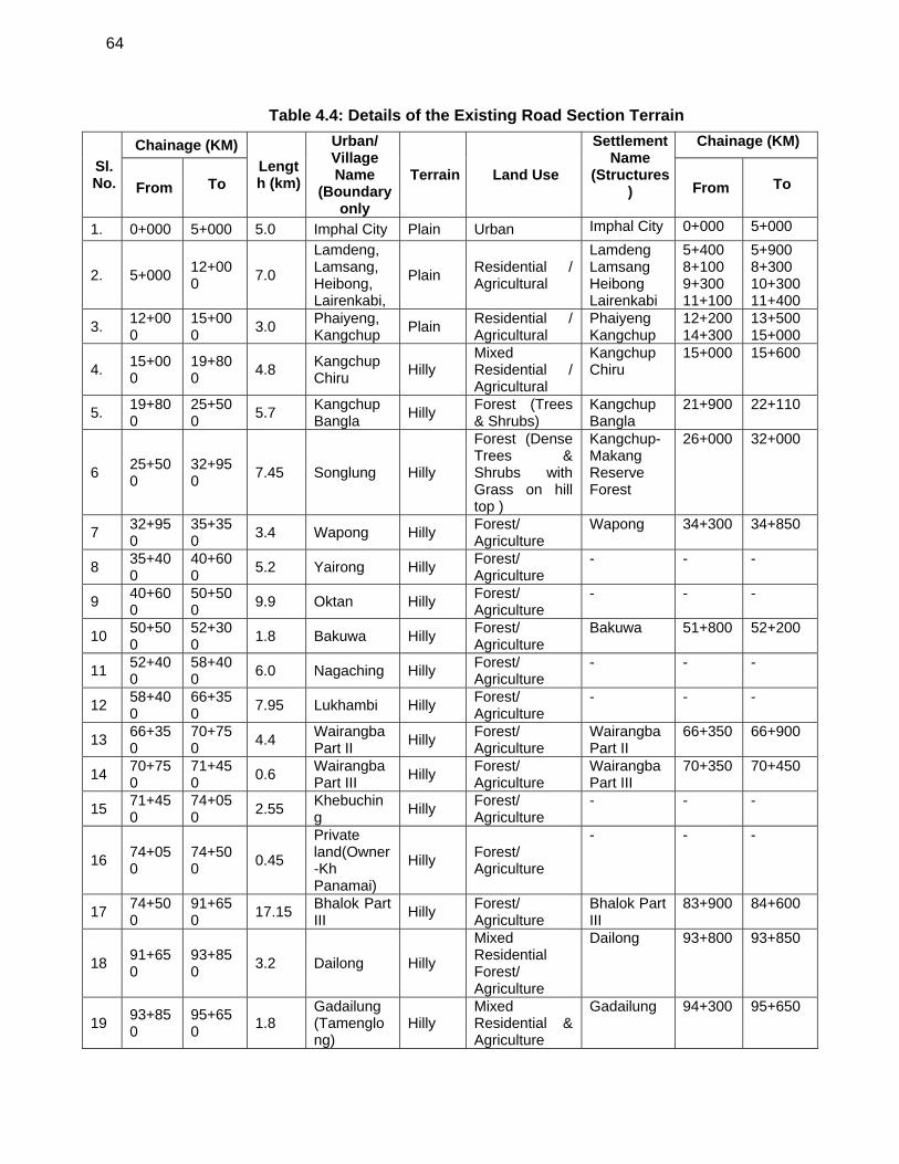
64
Table 4.4: Details of the Existing Road Section Terrain
Sl. No.
Chainage (KM)
Length (km)
Urban/ Village Name
(Boundary only
Terrain Land Use
Settlement Name
(Structures)
Chainage (KM)
From
To From
To
1. 0+000 5+000 5.0 Imphal City Plain Urban Imphal City 0+000 5+000
2. 5+000 12+000
7.0
Lamdeng, Lamsang, Heibong, Lairenkabi,
Plain Residential / Agricultural
Lamdeng Lamsang Heibong Lairenkabi
5+400 8+100 9+300 11+100
5+900 8+300 10+300 11+400
3. 12+000
15+000
3.0 Phaiyeng, Kangchup
Plain Residential / Agricultural
Phaiyeng Kangchup
12+200 14+300
13+500 15+000
4. 15+000
19+800
4.8 Kangchup Chiru
Hilly Mixed Residential / Agricultural
Kangchup Chiru
15+000 15+600
5. 19+800
25+500
5.7 Kangchup Bangla
Hilly Forest (Trees & Shrubs)
Kangchup Bangla
21+900 22+110
6 25+500
32+950
7.45 Songlung Hilly
Forest (Dense Trees & Shrubs with Grass on hill top )
Kangchup-Makang Reserve Forest
26+000 32+000
7 32+950
35+350
3.4 Wapong Hilly Forest/ Agriculture
Wapong 34+300 34+850
8 35+400
40+600
5.2 Yairong Hilly Forest/ Agriculture
- - -
9 40+600
50+500
9.9 Oktan Hilly Forest/ Agriculture
- - -
10 50+500
52+300
1.8 Bakuwa Hilly Forest/ Agriculture
Bakuwa 51+800 52+200
11 52+400
58+400
6.0 Nagaching Hilly Forest/ Agriculture
- - -
12 58+400
66+350
7.95 Lukhambi Hilly Forest/ Agriculture
- - -
13 66+350
70+750
4.4 Wairangba Part II
Hilly Forest/ Agriculture
Wairangba Part II
66+350 66+900
14 70+750
71+450
0.6 Wairangba Part III
Hilly Forest/ Agriculture
Wairangba Part III
70+350 70+450
15 71+450
74+050
2.55 Khebuching
Hilly Forest/ Agriculture
- - -
16 74+050
74+500
0.45
Private land(Owner-Kh Panamai)
Hilly Forest/ Agriculture
- - -
17 74+500
91+650
17.15 Bhalok Part III
Hilly Forest/ Agriculture
Bhalok Part III
83+900 84+600
18 91+650
93+850
3.2 Dailong Hilly
Mixed Residential Forest/ Agriculture
Dailong 93+800 93+850
19 93+850
95+650
1.8 Gadailung (Tamenglong)
Hilly Mixed Residential & Agriculture
Gadailung 94+300 95+650
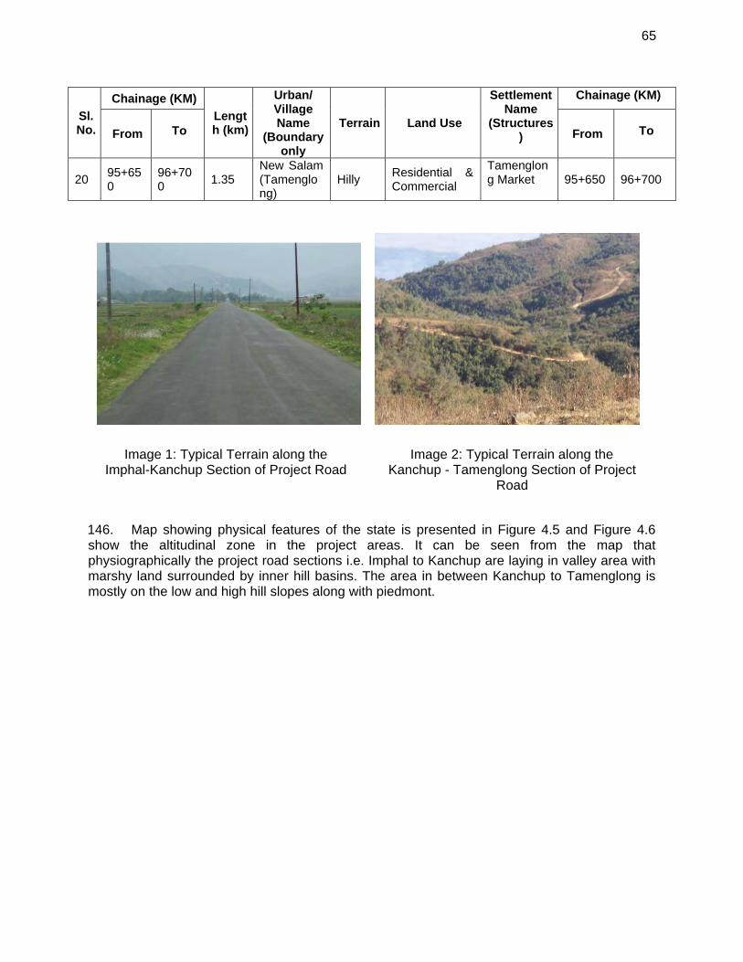
65
Sl. No.
Chainage (KM)
Length (km)
Urban/ Village Name
(Boundary only
Terrain Land Use
Settlement Name
(Structures)
Chainage (KM)
From
To From
To
20 95+650
96+700
1.35 New Salam (Tamenglong)
Hilly Residential & Commercial
Tamenglong Market 95+650 96+700
146. Map showing physical features of the state is presented in Figure 4.5 and Figure 4.6 show the altitudinal zone in the project areas. It can be seen from the map that physiographically the project road sections i.e. Imphal to Kanchup are laying in valley area with marshy land surrounded by inner hill basins. The area in between Kanchup to Tamenglong is mostly on the low and high hill slopes along with piedmont.
Image 1: Typical Terrain along the Imphal-Kanchup Section of Project Road
Image 2: Typical Terrain along the Kanchup - Tamenglong Section of Project
Road
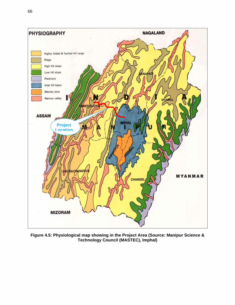
66
Figure 4.5: Physiological map showing in the Project Area (Source: Manipur Science & Technology Council (MASTEC), Imphal)
Project Location
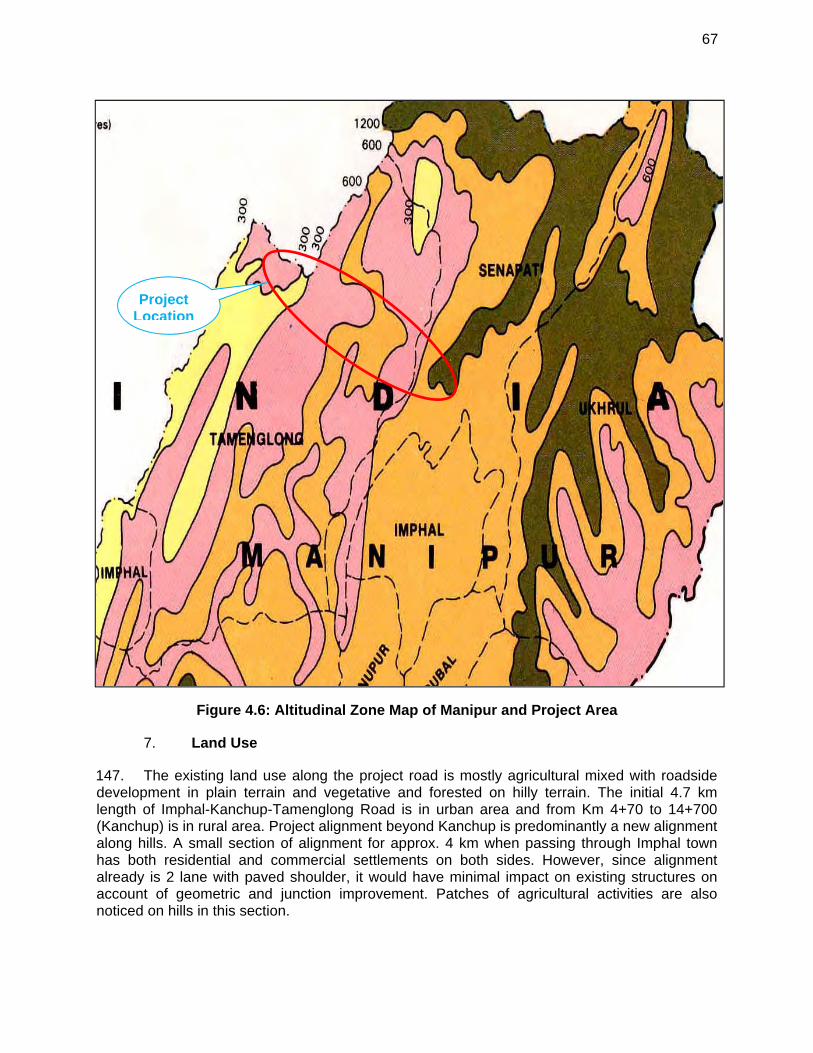
67
Figure 4.6: Altitudinal Zone Map of Manipur and Project Area
Land Use 7.
147. The existing land use along the project road is mostly agricultural mixed with roadside development in plain terrain and vegetative and forested on hilly terrain. The initial 4.7 km length of Imphal-Kanchup-Tamenglong Road is in urban area and from Km 4+70 to 14+700 (Kanchup) is in rural area. Project alignment beyond Kanchup is predominantly a new alignment along hills. A small section of alignment for approx. 4 km when passing through Imphal town has both residential and commercial settlements on both sides. However, since alignment already is 2 lane with paved shoulder, it would have minimal impact on existing structures on account of geometric and junction improvement. Patches of agricultural activities are also noticed on hills in this section.
Project Location
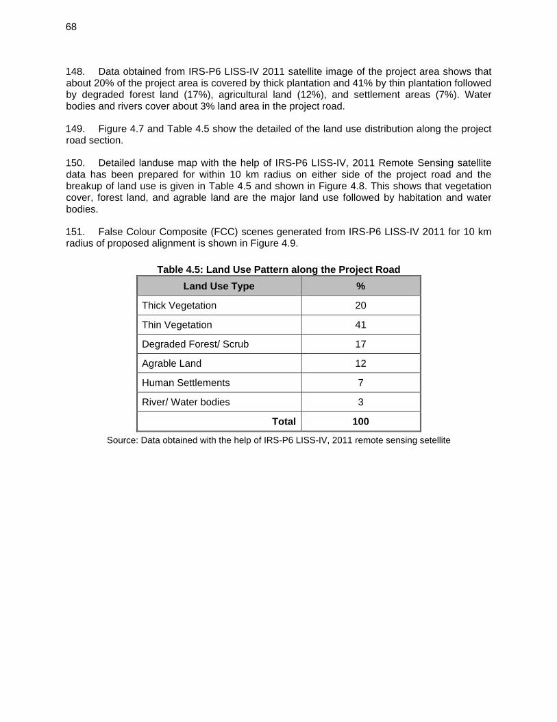
68
148. Data obtained from IRS-P6 LISS-IV 2011 satellite image of the project area shows that about 20% of the project area is covered by thick plantation and 41% by thin plantation followed by degraded forest land (17%), agricultural land (12%), and settlement areas (7%). Water bodies and rivers cover about 3% land area in the project road.
149. Figure 4.7 and Table 4.5 show the detailed of the land use distribution along the project road section.
150. Detailed landuse map with the help of IRS-P6 LISS-IV, 2011 Remote Sensing satellite data has been prepared for within 10 km radius on either side of the project road and the breakup of land use is given in Table 4.5 and shown in Figure 4.8. This shows that vegetation cover, forest land, and agrable land are the major land use followed by habitation and water bodies.
151. False Colour Composite (FCC) scenes generated from IRS-P6 LISS-IV 2011 for 10 km radius of proposed alignment is shown in Figure 4.9.
Table 4.5: Land Use Pattern along the Project Road
Land Use Type %
Thick Vegetation 20
Thin Vegetation 41
Degraded Forest/ Scrub 17
Agrable Land 12
Human Settlements 7
River/ Water bodies 3
Total 100
Source: Data obtained with the help of IRS-P6 LISS-IV, 2011 remote sensing setellite
69
Figure 4.7: Land Use Distribution along the Project Road
20%
41%
17%
12%
7%3%
TypeofLanduse
ThickVegetation
ThinVegetation
DegradedForest/Scrub
AgriculturalLand
HumanSettlements
Rivers/WaterBodies
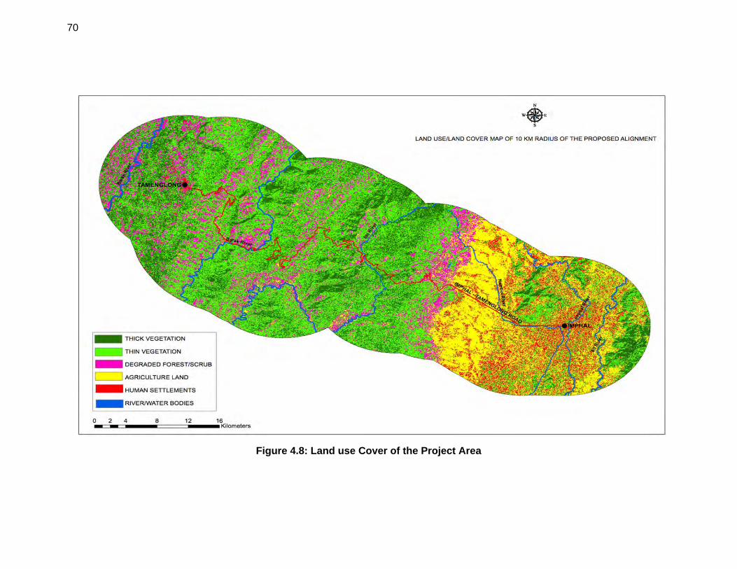
70
Figure 4.8: Land use Cover of the Project Area
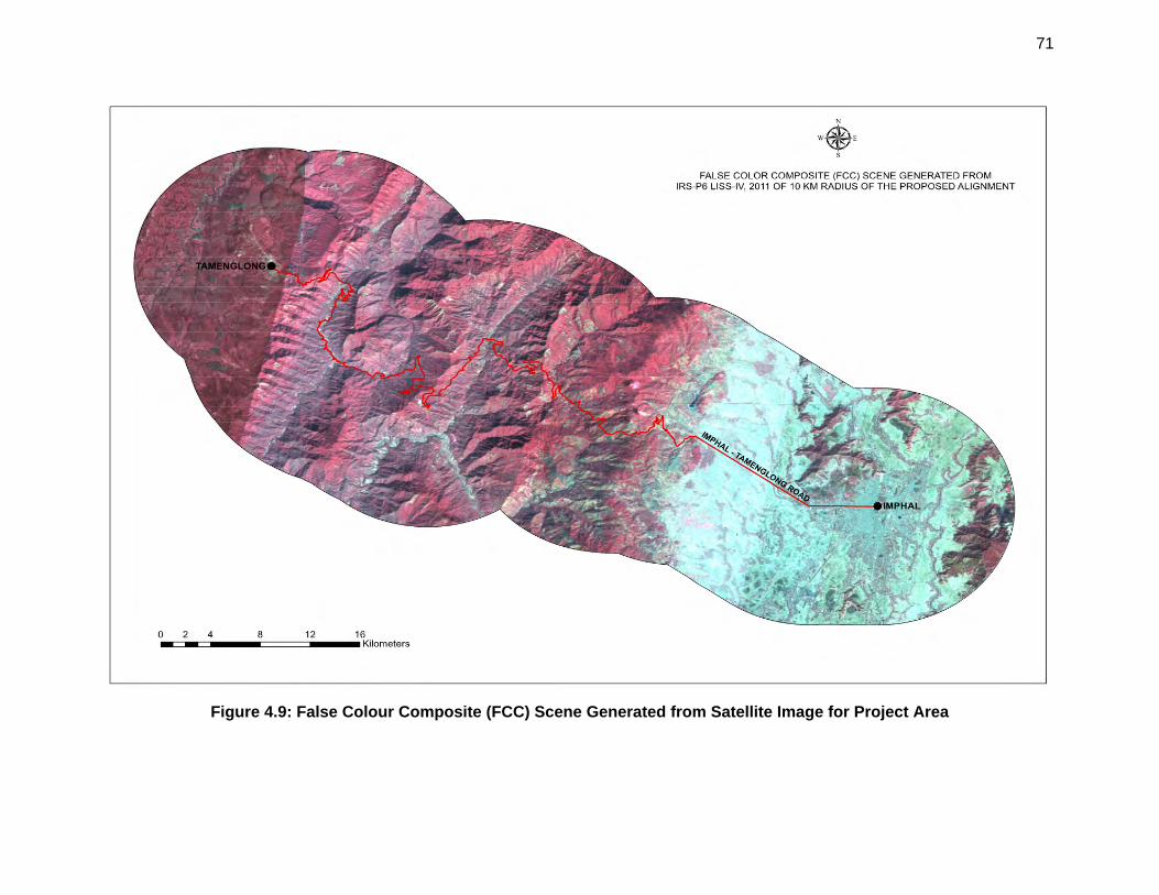
71
Figure 4.9: False Colour Composite (FCC) Scene Generated from Satellite Image for Project Area
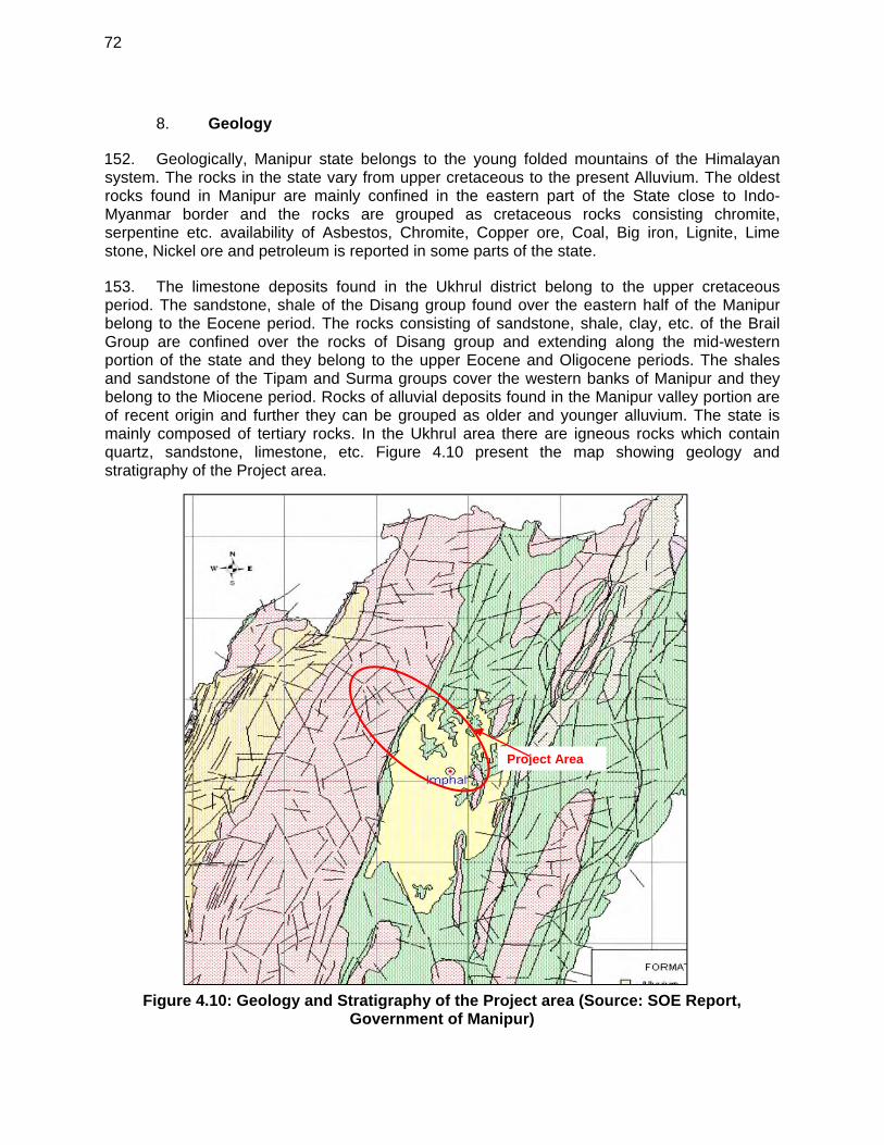
72
Geology 8.
152. Geologically, Manipur state belongs to the young folded mountains of the Himalayan system. The rocks in the state vary from upper cretaceous to the present Alluvium. The oldest rocks found in Manipur are mainly confined in the eastern part of the State close to Indo-Myanmar border and the rocks are grouped as cretaceous rocks consisting chromite, serpentine etc. availability of Asbestos, Chromite, Copper ore, Coal, Big iron, Lignite, Lime stone, Nickel ore and petroleum is reported in some parts of the state.
153. The limestone deposits found in the Ukhrul district belong to the upper cretaceous period. The sandstone, shale of the Disang group found over the eastern half of the Manipur belong to the Eocene period. The rocks consisting of sandstone, shale, clay, etc. of the Brail Group are confined over the rocks of Disang group and extending along the mid-western portion of the state and they belong to the upper Eocene and Oligocene periods. The shales and sandstone of the Tipam and Surma groups cover the western banks of Manipur and they belong to the Miocene period. Rocks of alluvial deposits found in the Manipur valley portion are of recent origin and further they can be grouped as older and younger alluvium. The state is mainly composed of tertiary rocks. In the Ukhrul area there are igneous rocks which contain quartz, sandstone, limestone, etc. Figure 4.10 present the map showing geology and stratigraphy of the Project area.
Figure 4.10: Geology and Stratigraphy of the Project area (Source: SOE Report, Government of Manipur)
Project Area
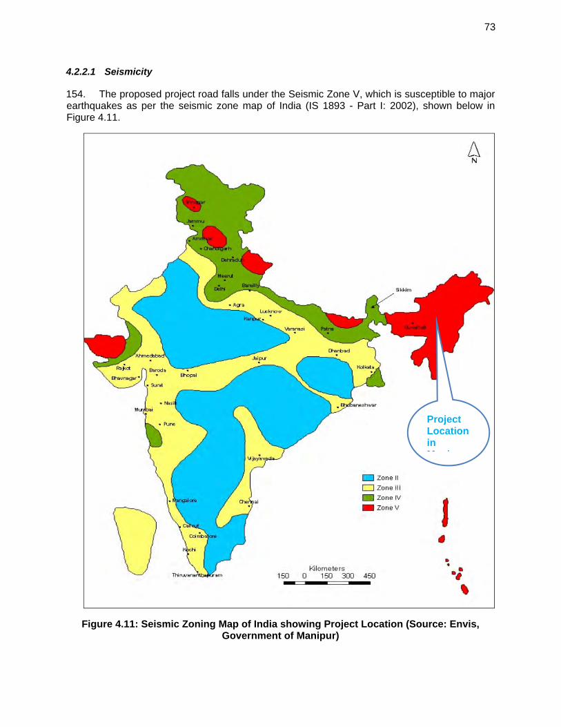
73
4.2.2.1 Seismicity
154. The proposed project road falls under the Seismic Zone V, which is susceptible to major earthquakes as per the seismic zone map of India (IS 1893 - Part I: 2002), shown below in Figure 4.11.
Figure 4.11: Seismic Zoning Map of India showing Project Location (Source: Envis, Government of Manipur)
Project Location in M i
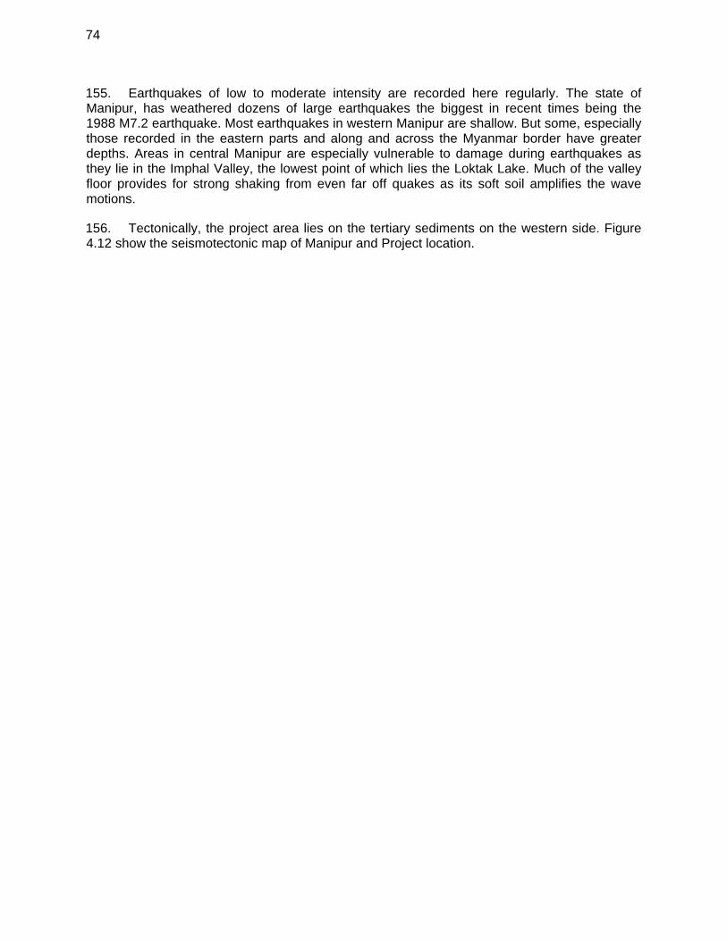
74
155. Earthquakes of low to moderate intensity are recorded here regularly. The state of Manipur, has weathered dozens of large earthquakes the biggest in recent times being the 1988 M7.2 earthquake. Most earthquakes in western Manipur are shallow. But some, especially those recorded in the eastern parts and along and across the Myanmar border have greater depths. Areas in central Manipur are especially vulnerable to damage during earthquakes as they lie in the Imphal Valley, the lowest point of which lies the Loktak Lake. Much of the valley floor provides for strong shaking from even far off quakes as its soft soil amplifies the wave motions.
156. Tectonically, the project area lies on the tertiary sediments on the western side. Figure 4.12 show the seismotectonic map of Manipur and Project location.
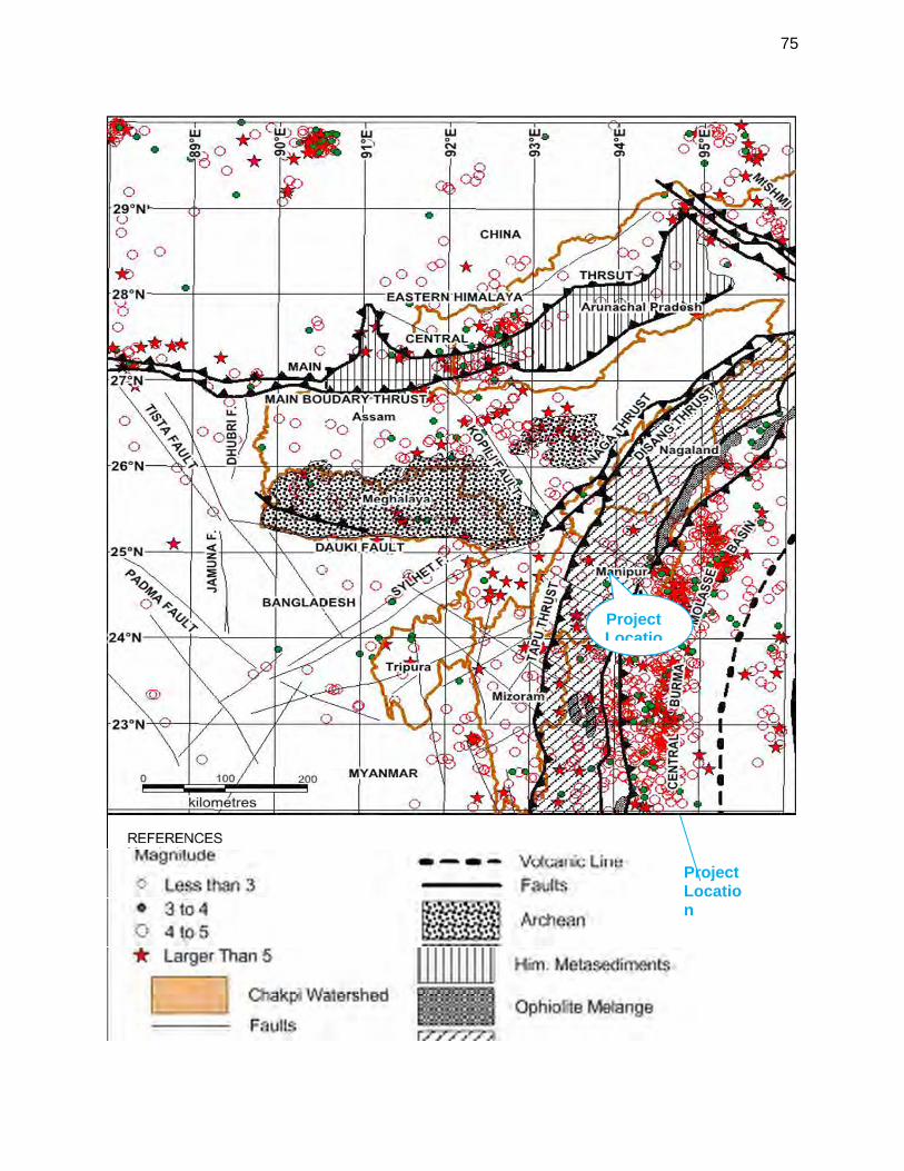
75
Project Location
Project Locatio
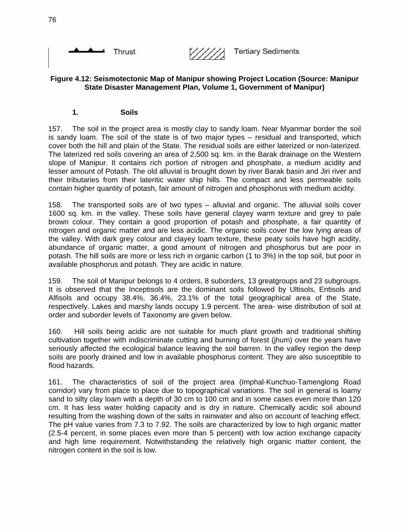
76
Figure 4.12: Seismotectonic Map of Manipur showing Project Location (Source: Manipur State Disaster Management Plan, Volume 1, Government of Manipur)
1. Soils
157. The soil in the project area is mostly clay to sandy loam. Near Myanmar border the soil is sandy loam. The soil of the state is of two major types – residual and transported, which cover both the hill and plain of the State. The residual soils are either laterized or non-laterized. The laterized red soils covering an area of 2,500 sq. km. in the Barak drainage on the Western slope of Manipur. It contains rich portion of nitrogen and phosphate, a medium acidity and lesser amount of Potash. The old alluvial is brought down by river Barak basin and Jiri river and their tributaries from their lateritic water ship hills. The compact and less permeable soils contain higher quantity of potash, fair amount of nitrogen and phosphorus with medium acidity.
158. The transported soils are of two types – alluvial and organic. The alluvial soils cover 1600 sq. km. in the valley. These soils have general clayey warm texture and grey to pale brown colour. They contain a good proportion of potash and phosphate, a fair quantity of nitrogen and organic matter and are less acidic. The organic soils cover the low lying areas of the valley. With dark grey colour and clayey loam texture, these peaty soils have high acidity, abundance of organic matter, a good amount of nitrogen and phosphorus but are poor in potash. The hill soils are more or less rich in organic carbon (1 to 3%) in the top soil, but poor in available phosphorus and potash. They are acidic in nature.
159. The soil of Manipur belongs to 4 orders, 8 suborders, 13 greatgroups and 23 subgroups. It is observed that the Inceptisols are the dominant soils followed by Ultisols, Entisols and Alfisols and occupy 38.4%, 36.4%, 23.1% of the total geographical area of the State, respectively. Lakes and marshy lands occupy 1.9 percent. The area- wise distribution of soil at order and suborder levels of Taxonomy are given below.
160. Hill soils being acidic are not suitable for much plant growth and traditional shifting cultivation together with indiscriminate cutting and burning of forest (jhum) over the years have seriously affected the ecological balance leaving the soil barren. In the valley region the deep soils are poorly drained and low in available phosphorus content. They are also susceptible to flood hazards.
161. The characteristics of soil of the project area (Imphal-Kunchuo-Tamenglong Road corridor) vary from place to place due to topographical variations. The soil in general is loamy sand to silty clay loam with a depth of 30 cm to 100 cm and in some cases even more than 120 cm. It has less water holding capacity and is dry in nature. Chemically acidic soil abound resulting from the washing down of the salts in rainwater and also on account of leaching effect. The pH value varies from 7.3 to 7.92. The soils are characterized by low to high organic matter (2.5-4 percent, in some places even more than 5 percent) with low action exchange capacity and high lime requirement. Notwithstanding the relatively high organic matter content, the nitrogen content in the soil is low.
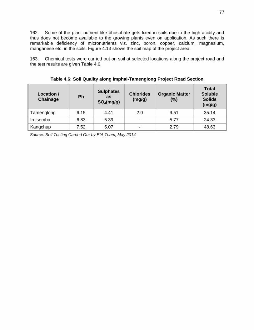
77
162. Some of the plant nutrient like phosphate gets fixed in soils due to the high acidity and thus does not become available to the growing plants even on application. As such there is remarkable deficiency of micronutrients viz. zinc, boron, copper, calcium, magnesium, manganese etc. in the soils. Figure 4.13 shows the soil map of the project area.
163. Chemical tests were carried out on soil at selected locations along the project road and the test results are given Table 4.6.
Table 4.6: Soil Quality along Imphal-Tamenglong Project Road Section
Location / Chainage
Ph Sulphates
as SO4(mg/g)
Chlorides (mg/g)
Organic Matter (%)
Total Soluble Solids (mg/g)
Tamenglong 6.15 4.41 2.0 9.51 35.14
Iroisemba 6.83 5.39 - 5.77 24.33
Kangchup 7.52 5.07 - 2.79 48.63
Source: Soil Testing Carried Our by EIA Team, May 2014
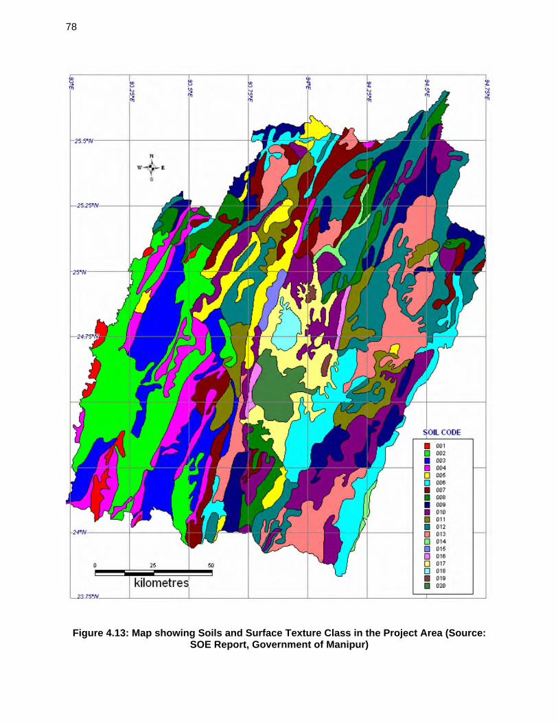
78
Figure 4.13: Map showing Soils and Surface Texture Class in the Project Area (Source: SOE Report, Government of Manipur)
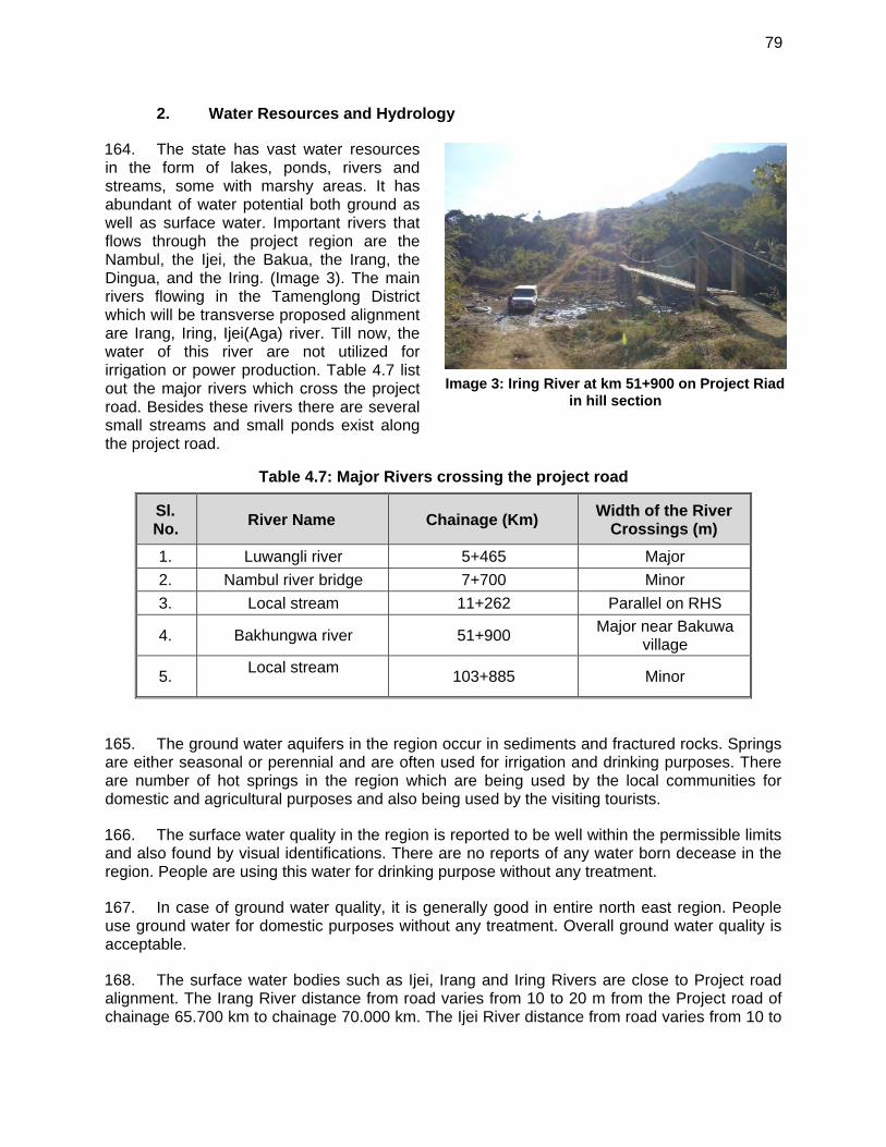
79
Image 3: Iring River at km 51+900 on Project Riad
in hill section
2. Water Resources and Hydrology
164. The state has vast water resources in the form of lakes, ponds, rivers and streams, some with marshy areas. It has abundant of water potential both ground as well as surface water. Important rivers that flows through the project region are the Nambul, the Ijei, the Bakua, the Irang, the Dingua, and the Iring. (Image 3). The main rivers flowing in the Tamenglong District which will be transverse proposed alignment are Irang, Iring, Ijei(Aga) river. Till now, the water of this river are not utilized for irrigation or power production. Table 4.7 list out the major rivers which cross the project road. Besides these rivers there are several small streams and small ponds exist along the project road.
Table 4.7: Major Rivers crossing the project road
Sl. No.
River Name Chainage (Km) Width of the River
Crossings (m)
1. Luwangli river 5+465 Major
2. Nambul river bridge 7+700 Minor
3. Local stream 11+262 Parallel on RHS
4. Bakhungwa river 51+900 Major near Bakuwa
village
5. Local stream
103+885 Minor
165. The ground water aquifers in the region occur in sediments and fractured rocks. Springs are either seasonal or perennial and are often used for irrigation and drinking purposes. There are number of hot springs in the region which are being used by the local communities for domestic and agricultural purposes and also being used by the visiting tourists.
166. The surface water quality in the region is reported to be well within the permissible limits and also found by visual identifications. There are no reports of any water born decease in the region. People are using this water for drinking purpose without any treatment.
167. In case of ground water quality, it is generally good in entire north east region. People use ground water for domestic purposes without any treatment. Overall ground water quality is acceptable.
168. The surface water bodies such as Ijei, Irang and Iring Rivers are close to Project road alignment. The Irang River distance from road varies from 10 to 20 m from the Project road of chainage 65.700 km to chainage 70.000 km. The Ijei River distance from road varies from 10 to
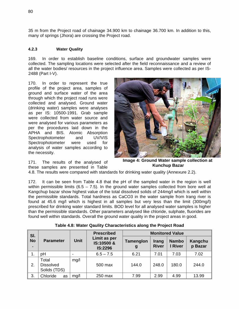
80
Image 4: Ground Water sample collection at
Kunchup Bazar
35 m from the Project road of chainage 34.900 km to chainage 36.700 km. In addition to this, many of springs (Jhora) are crossing the Project road.
4.2.3 Water Quality
169. In order to establish baseline conditions, surface and groundwater samples were collected. The sampling locations were selected after the field reconnaissance and a review of all the water bodies/ resources in the project influence area. Samples were collected as per IS- 2488 (Part I-V).
170. In order to represent the true profile of the project area, samples of ground and surface water of the area through which the project road runs were collected and analysed. Ground water (drinking water) samples were analyses as per IS: 10500-1991. Grab sample were collected from water source and were analysed for various parameters as per the procedures laid down in the APHA and BIS. Atomic Absorption Spectrophotometer and UV/VIS Spectrophotometer were used for analysis of water samples according to the necessity.
171. The results of the analysed of these samples are presented in Table 4.8. The results were compared with standards for drinking water quality (Annexure 2.2).
172. It can be seen from Table 4.8 that the pH of the sampled water in the region is well within permissible limits (6.5 – 7.5). In the ground water samples collected from bore well at Kangchup bazar show highest value of the total dissolved solids of 244mg/l which is well within the permissible standards. Total hardness as CaCO3 in the water sample from Irang river is found at 45.6 mg/l which is highest in all samples but very less than the limit (300mg/l) prescribed for drinking water standard limits. BOD level for all analysed water samples is higher than the permissible standards. Other parameters analysed like chloride, sulphate, fluorides are found well within standards. Overall the ground water quality in the project areas in good.
Table 4.8: Water Qaulity Characteristics along the Project Road
Sl. No.
Parameter Unit
Prescribed Limit as per IS:10500 &
IS:2296
Monitored Value
Tamenglong
Irang River
Nambol River
Kangchup Bazar
1. pH - 6.5 – 7.5 6.21 7.01 7.03 7.02
2. Total Dissolved Solids (TDS)
mg/l 500 max 144.0 248.0 180.0 244.0
3. Chloride as mg/l 250 max 7.99 2.99 4.99 13.99
81
Image 6: Air Quality Monitoring Station Setup at Eroisemba Police Post (AQ1)
Cl-
4. Sulphate as SO4
mg/l 200 max 5.16 18.31 4.0 4.5
5. Total hardness as CaCO3
mg/l 300 max 24.7 45.6 39.9 26.6
6. COD mg/l 200 max 19.6 39.2 29.4 19.6 7. BOD 5 day mg/l 2 max < 5.0 5.51 5.14 < 5.0 8. Fluoride as F mg/l 1 max <1.0 <1.0 <1.0 <1.0
Source: Water Quality Monitoring carried out by EIA Team, 2014
3. Air Quality
173. Ambient air quality in the state is quite pure compared to other neighbouring states. Except for few urban centres like Imphal, Thoubal and Moreh, the ambient air quality is good. There are no major industrial activities in the State. Dust arising from unpaved surfaces, forest fire, smoke charcoal production and domestic heating, and vehicular pollution are sources of pollution in the region. Firewood burning is the major contributor in the ambient pollution load. Industrial and vehicular pollution is mainly concentrated in the major commercial areas in State capital.
174. Vehicular pollution is a secondary source of pollution in the state as the traffic density is low. Pollution from vehicles is mainly due to use of low-grade fuel, and poor maintenance of vehicles. The level of pollution in rural areas is much lower than that of the urban areas due to lower volume of traffic. The traffic density in the state is very low. There is sudden increase in the number of vehicles in the town area during the last one decade producing a lot of smoke. The use of a large number of second-hand diesel jeeps as transport is another cause of air pollution.
175. Secondary information is not available on ambient air quality of the project road area. The major transport on the project section is the traffic flowing on project road connecting Tamenglong with Imphal and to rest of the country as well as traffic flow towards Moreh from Imphal and from Assam. This might also add to the air pollution load on the project section.
176. The base-line status of the ambient air-quality was assessed using a scientifically designed ambient air-quality monitoring network. The design of this network was based on the following:
meteorological conditions; the assumed regional influences on
background air quality; the areas where impact would most
likely be greatest; present land use along the proposed
alignment; and traffic congestion points.
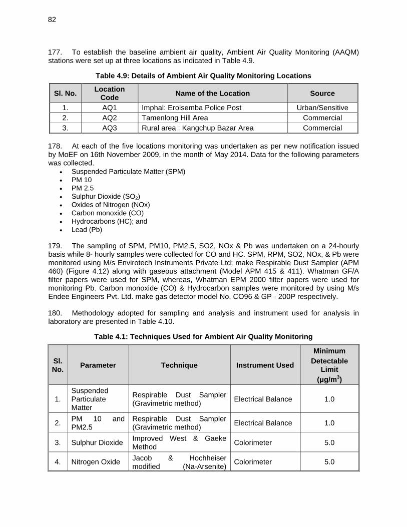
82
177. To establish the baseline ambient air quality, Ambient Air Quality Monitoring (AAQM) stations were set up at three locations as indicated in Table 4.9.
Table 4.9: Details of Ambient Air Quality Monitoring Locations
Sl. No. Location
Code Name of the Location Source
1. AQ1 Imphal: Eroisemba Police Post Urban/Sensitive 2. AQ2 Tamenlong Hill Area Commercial 3. AQ3 Rural area : Kangchup Bazar Area Commercial
178. At each of the five locations monitoring was undertaken as per new notification issued by MoEF on 16th November 2009, in the month of May 2014. Data for the following parameters was collected.
Suspended Particulate Matter (SPM) PM 10 PM 2.5 Sulphur Dioxide (SO2) Oxides of Nitrogen (NOx) Carbon monoxide (CO) Hydrocarbons (HC); and Lead (Pb)
179. The sampling of SPM, PM10, PM2.5, SO2, NOx & Pb was undertaken on a 24-hourly basis while 8- hourly samples were collected for CO and HC. SPM, RPM, SO2, NOx, & Pb were monitored using M/s Envirotech Instruments Private Ltd; make Respirable Dust Sampler (APM 460) (Figure 4.12) along with gaseous attachment (Model APM 415 & 411). Whatman GF/A filter papers were used for SPM, whereas, Whatman EPM 2000 filter papers were used for monitoring Pb. Carbon monoxide (CO) & Hydrocarbon samples were monitored by using M/s Endee Engineers Pvt. Ltd. make gas detector model No. CO96 & GP - 200P respectively.
180. Methodology adopted for sampling and analysis and instrument used for analysis in laboratory are presented in Table 4.10.
Table 4.1: Techniques Used for Ambient Air Quality Monitoring
Sl. No.
Parameter Technique Instrument Used
Minimum Detectable
Limit (μg/m3)
1. Suspended Particulate Matter
Respirable Dust Sampler (Gravimetric method)
Electrical Balance 1.0
2. PM 10 and PM2.5
Respirable Dust Sampler (Gravimetric method)
Electrical Balance 1.0
3. Sulphur Dioxide Improved West & Gaeke Method
Colorimeter 5.0
4. Nitrogen Oxide Jacob & Hochheiser modified (Na-Arsenite)
Colorimeter 5.0
83
Method
5. Carbon Monoxide
Gas Chromatograph 0.01
6. Hydrocarbons Gas Chromatograph 0.01
7. Lead AAS Method after sampling using EPM 2000 filter paper
Atomic Absorption Spectrophotometer
0.01
181. A summary of results for each location is presented in Table 4.11. Figure 4.13 & Figure 4.14 shows the graphically presentation of the existing air quality along the project road at five monitored locations. These results are compared with the new National Ambient Air Quality Standards prescribed by the MoEF for respective zones.
Table 4.2: Summary of AAQM Results (Average Values)
Location Parameter and Values (μg/m3)
SPM PM10 PM2.5 NOx SO2 Pb CO HC
Standard for
Sensitive 100 100 60 80 80 1.0 4000 1000
Standard for
Residential 200 100 60 80 80 1.0 4000 2000
AQ1 207.01 66.48 31.66 30.13 6.85 BDL 0.695 BDL*
AQ2 170.3 54.89 25.22 28.23 5.97 BDL 0.512 BDL
AQ3 196.26 62.06 29.51 29.45 6.43 BDL 0.642 BDL
Note: BDL-Below Detectable Limit
Source: Ambient Air Quality Monitoring carried out by EIA Team, 2014
182. It can be seen from the Table 4.11 that out of three locations of air monitoring the SPM concentration at AQ1 marginally exceeds permissible limits for residential zone i.e. 200 μg/m3 prescribed by MoEF. While at other locations AQ2 & AQ3 the SPM conc. is well within limits. While PM10 concentration at all the monitored locations less than the new permissible limit i.e. 100 μg/m3 prescribed by MoEF for sensitive areas. Other parameters monitored i.e. PM2.5, NOx. SO2 were found within the permissible limits for all the locations. Overall the air quality in the project area in not an issue. The National Ambient Air Quality Standards (NAAQS) prescribed by MOEF are given in Annexure 2.3.
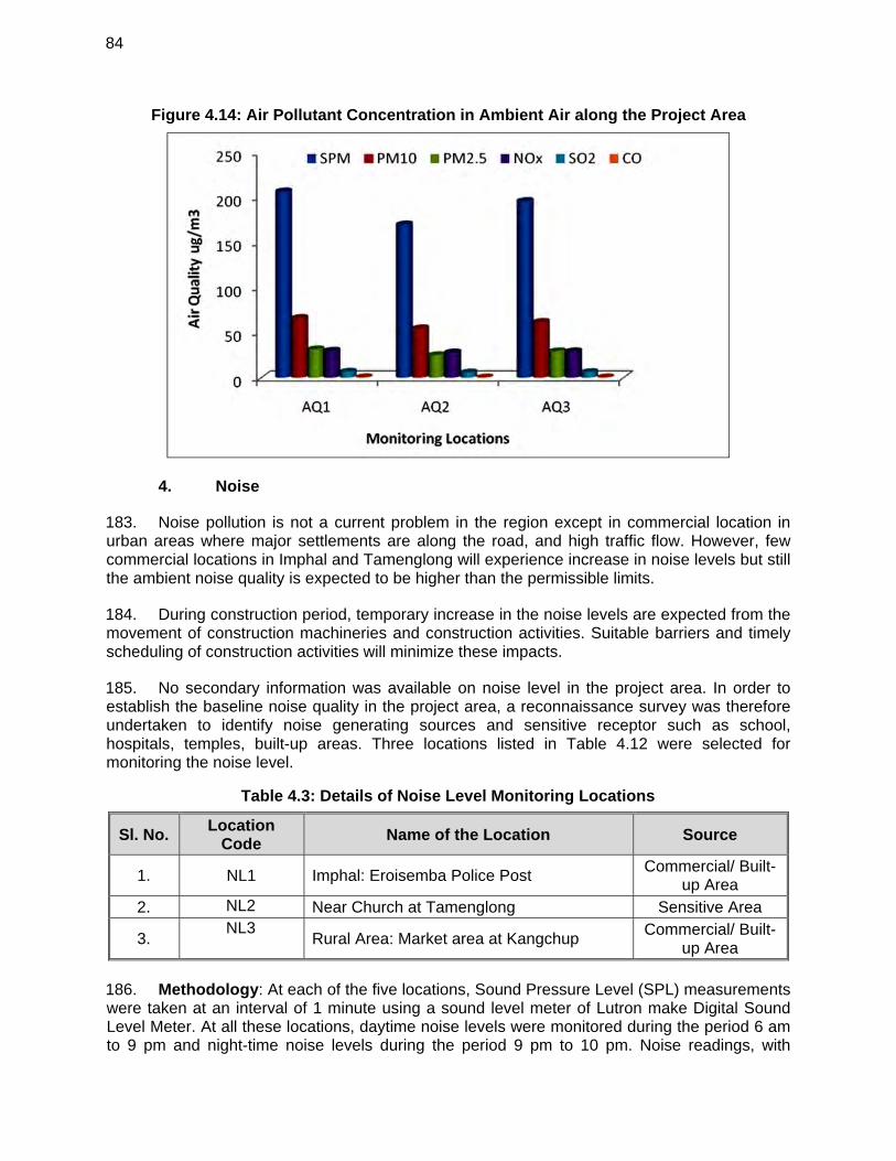
84
Figure 4.14: Air Pollutant Concentration in Ambient Air along the Project Area
4. Noise
183. Noise pollution is not a current problem in the region except in commercial location in urban areas where major settlements are along the road, and high traffic flow. However, few commercial locations in Imphal and Tamenglong will experience increase in noise levels but still the ambient noise quality is expected to be higher than the permissible limits.
184. During construction period, temporary increase in the noise levels are expected from the movement of construction machineries and construction activities. Suitable barriers and timely scheduling of construction activities will minimize these impacts.
185. No secondary information was available on noise level in the project area. In order to establish the baseline noise quality in the project area, a reconnaissance survey was therefore undertaken to identify noise generating sources and sensitive receptor such as school, hospitals, temples, built-up areas. Three locations listed in Table 4.12 were selected for monitoring the noise level.
Table 4.3: Details of Noise Level Monitoring Locations
Sl. No. Location
Code Name of the Location Source
1. NL1 Imphal: Eroisemba Police Post Commercial/ Built-
up Area 2. NL2 Near Church at Tamenglong Sensitive Area
3. NL3
Rural Area: Market area at Kangchup Commercial/ Built-
up Area 186. Methodology: At each of the five locations, Sound Pressure Level (SPL) measurements were taken at an interval of 1 minute using a sound level meter of Lutron make Digital Sound Level Meter. At all these locations, daytime noise levels were monitored during the period 6 am to 9 pm and night-time noise levels during the period 9 pm to 10 pm. Noise readings, with
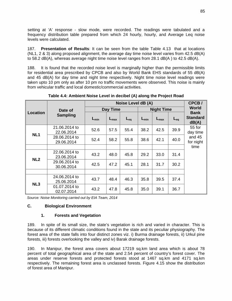
85
setting at ‘A’ response - slow mode, were recorded. The readings were tabulated and a frequency distribution table prepared from which 24 hourly, hourly, and Average Leq noise levels were calculated.
187. Presentation of Results: It can be seen from the table Table 4.13 that at locations (NL1, 2 & 3) along proposed alignment, the average day time noise level varies from 42.5 dB(A) to 58.2 dB(A), whereas average night time noise level ranges from 28.1 dB(A ) to 42.5 dB(A).
188. It is found that the recorded noise level is marginally higher than the permissible limits for residential area prescribed by CPCB and also by World Bank EHS standards of 55 dB(A) and 45 dB(A) for day time and night time respectively. Night time noise level readings were taken upto 10 pm only as after 10 pm no traffic movements were observed. This noise is mainly from vehicular traffic and local domestic/commercial activities.
Table 4.4: Ambient Noise Level in decibel (A) along the Project Road
Location Date of
Sampling
Noise Level dB (A) CPCB / World Bank
Standard dB(A)
Day Time Night Time
Lmin Lmax Leq Lmin Lmax Leq
NL1
21.06.2014 to 22.06.2014
52.6 57.5 55.4 38.2 42.5 39.9 55 for
day time and 45
for night time
28.06.2014 to 29.06.2014
52.4 58.2 55.8 38.6 42.1 40.0
NL2
22.06.2014 to 23.06.2014
43.2 48.0 45.8 29.2 33.0 31.4
29.06.2014 to 30.06.2014
42.5 47.2 45.1 28.1 31.7 30.2
NL3
24.06.2014 to 25.06.2014
43.7 48.4 46.3 35.8 39.5 37.4
01.07.2014 to 02.07.2014
43.2 47.8 45.8 35.0 39.1 36.7
Source: Noise Monitoring carried out by EIA Team, 2014
C. Biological Environment
1. Forests and Vegetation
189. In spite of its small size, the state’s vegetation is rich and varied in character. This is because of its different climatic conditions found in the state and its peculiar physiography. The forest area of the state falls into four distinct zones viz. i) Burma drainage forests, ii) Urkul pine forests, iii) forests overlooking the valley and iv) Barak drainage forests.
190. In Manipur, the forest area covers about 17219 sq.km land area which is about 78 percent of total geographical area of the state and 2.54 percent of country’s forest cover. The areas under reserve forests and protected forests stood at 1467 sq.km and 4171 sq.km respectively. The remaining forest area is unclassed forests. Figure 4.15 show the distribution of forest area of Manipur.
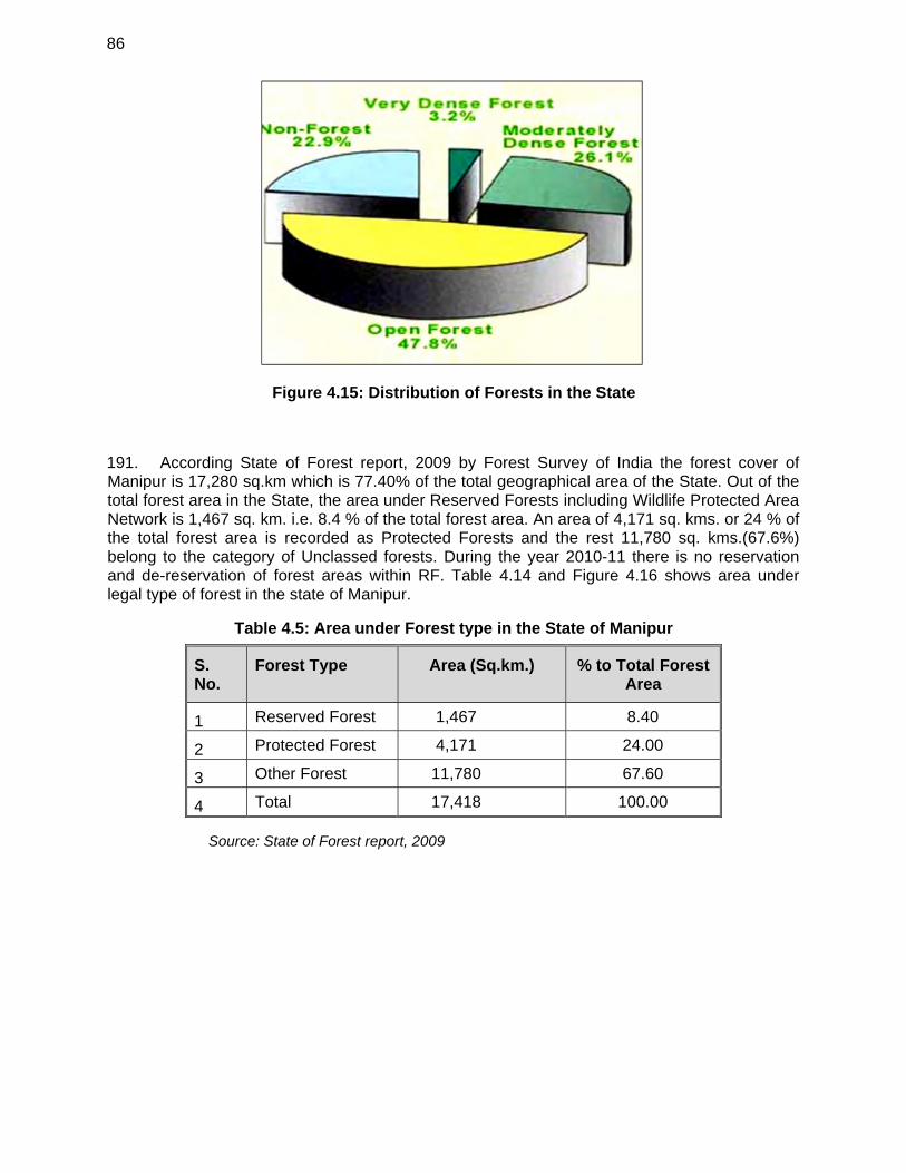
86
Figure 4.15: Distribution of Forests in the State
191. According State of Forest report, 2009 by Forest Survey of India the forest cover of Manipur is 17,280 sq.km which is 77.40% of the total geographical area of the State. Out of the total forest area in the State, the area under Reserved Forests including Wildlife Protected Area Network is 1,467 sq. km. i.e. 8.4 % of the total forest area. An area of 4,171 sq. kms. or 24 % of the total forest area is recorded as Protected Forests and the rest 11,780 sq. kms.(67.6%) belong to the category of Unclassed forests. During the year 2010-11 there is no reservation and de-reservation of forest areas within RF. Table 4.14 and Figure 4.16 shows area under legal type of forest in the state of Manipur.
Table 4.5: Area under Forest type in the State of Manipur
S. No.
Forest Type Area (Sq.km.) % to Total Forest Area
1 Reserved Forest 1,467 8.40
2 Protected Forest 4,171 24.00
3 Other Forest 11,780 67.60
4 Total 17,418 100.00
Source: State of Forest report, 2009
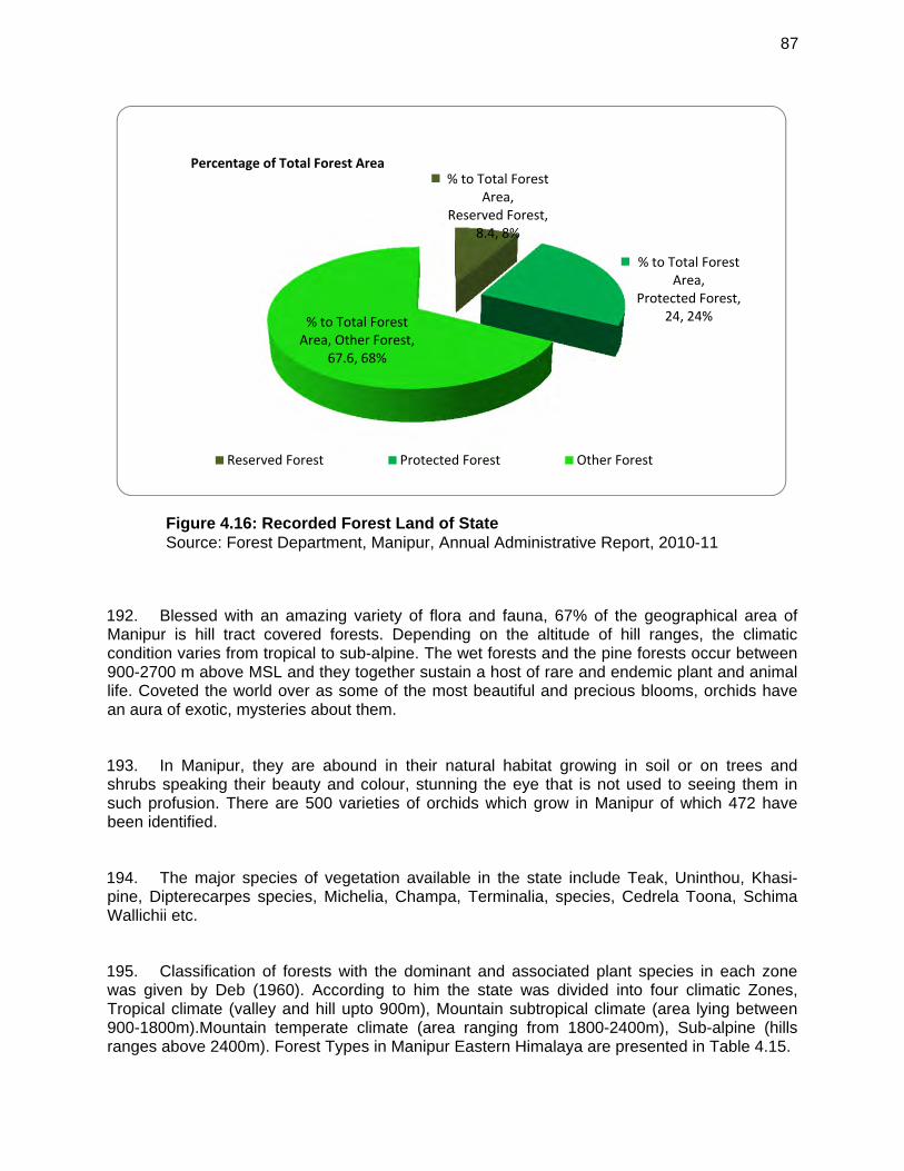
87
Figure 4.16: Recorded Forest Land of State Source: Forest Department, Manipur, Annual Administrative Report, 2010-11
192. Blessed with an amazing variety of flora and fauna, 67% of the geographical area of Manipur is hill tract covered forests. Depending on the altitude of hill ranges, the climatic condition varies from tropical to sub-alpine. The wet forests and the pine forests occur between 900-2700 m above MSL and they together sustain a host of rare and endemic plant and animal life. Coveted the world over as some of the most beautiful and precious blooms, orchids have an aura of exotic, mysteries about them.
193. In Manipur, they are abound in their natural habitat growing in soil or on trees and shrubs speaking their beauty and colour, stunning the eye that is not used to seeing them in such profusion. There are 500 varieties of orchids which grow in Manipur of which 472 have been identified.
194. The major species of vegetation available in the state include Teak, Uninthou, Khasi-pine, Dipterecarpes species, Michelia, Champa, Terminalia, species, Cedrela Toona, Schima Wallichii etc.
195. Classification of forests with the dominant and associated plant species in each zone was given by Deb (1960). According to him the state was divided into four climatic Zones, Tropical climate (valley and hill upto 900m), Mountain subtropical climate (area lying between 900-1800m).Mountain temperate climate (area ranging from 1800-2400m), Sub-alpine (hills ranges above 2400m). Forest Types in Manipur Eastern Himalaya are presented in Table 4.15.
% to Total Forest Area,
Reserved Forest, 8.4, 8%
% to Total Forest Area,
Protected Forest, 24, 24%% to Total Forest
Area, Other Forest, 67.6, 68%
Percentage of Total Forest Area
Reserved Forest Protected Forest Other Forest
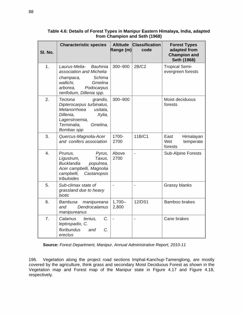
88
Table 4.6: Details of Forest Types in Manipur Eastern Himalaya, India, adapted from Champion and Seth (1968)
Sl. No.
Characteristic species Altitude Range (m)
Classification code
Forest Types adapted from
Champion and Seth (1968)
1. Laurus-Melia- Bauhinia association and Michelia champaca, Schima wallichi, Gmelina arborea, Podocarpus nerifolium, Dillenia spp.
300–900 2B/C2 Tropical Semi-evergreen forests
2. Tectona grandis, Dipterocarpus turbinatus, Melanorrhoea usitata, Dillenia, Xylia, Lagerstroemia, Terminalia, Gmelina, Bombax spp
300–900 Moist deciduous forests
3. Quercus-Magnolia-Acer and conifers association
1700-2700
11B/C1 East Himalayan Wet temperate forests
4. Prunus, Pyrus, Ligustrum, Taxus, Bucklandia populnea, Acer campbelli, Magnolia campbelli, Castanopsis tribuloides
Above 2700
- Sub-Alpine Forests
5. Sub-climax state of grassland due to heavy biotic
- - Grassy blanks
6. Bambusa manipureana and Dendrocalamus manipureanus
1,700–2,800
12/DS1 Bamboo brakes
7. Calamus tenius, C. leptospadix, C. floribundus and C. erectus
- - Cane brakes
Source: Forest Department, Manipur, Annual Administrative Report, 2010-11
196. Vegetation along the project road sections Imphal-Kanchup-Tamenglong, are mostly covered by the agriculture, think grass and secondary Moist Deciduous Forest as shown in the Vegetation map and Forest map of the Manipur state in Figure 4.17 and Figure 4.18, respectively.
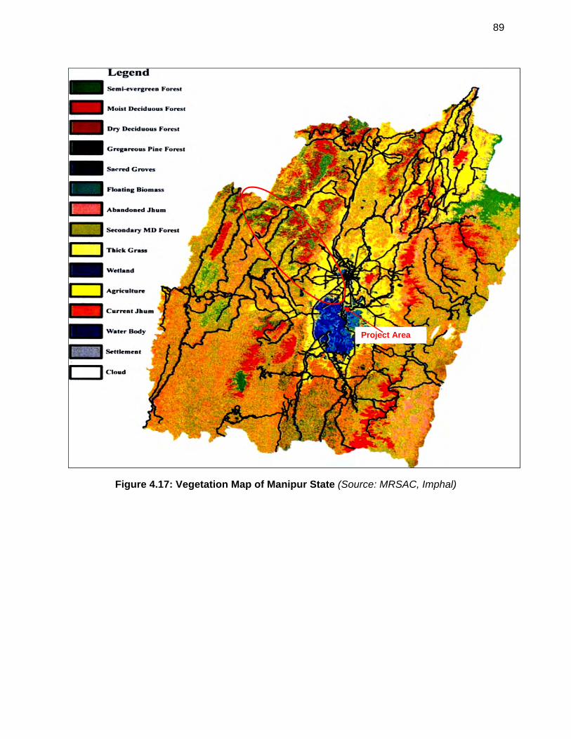
89
Figure 4.17: Vegetation Map of Manipur State (Source: MRSAC, Imphal)
Project Area
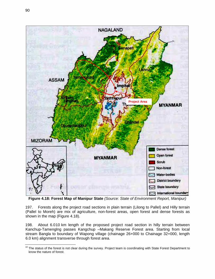
90
Figure 4.18: Forest Map of Manipur State (Source: State of Environment Report, Manipur)
197. Forests along the project road sections in plain terrain (Lilong to Pallel) and Hilly terrain (Pallel to Moreh) are mix of agriculture, non-forest areas, open forest and dense forests as shown in the map (Figure 4.18).
198. About 6.010 km length of the proposed project road section in hilly terrain between Kanchup-Tamenglng passes Kangchup –Makang Reserve Forest area. Starting from local stream Bangla to boundary of Wapong village (chainage 26+000 to Chainage 32+000, length 6.0 km) alignment transverse through forest area.
10 The status of the forest is not clear during the survey. Project team is coordinating with State Forest Department to
know the nature of forest.
Project Area
91
199. In plain terrain from starting point at chainage km 0.000 to 5+000 the land use is of built-up (major settlements Imphal city) and from chainage 5+000 to 15+000 the landuse of mixed type of residential and agriculture. While in hilly terrain at chainage km 15+000 onwards landuse is mixed of built-up (small settlements), agriculture and unclassified forests area of Senapati Forest Division and Tamenglong Forest Division.
200. Details of the forest locations along the project road sections are listed in Table 4.16.
Table 4.7: Details of Forest Locations along the Project Road sections
Sl. No. Name of Reserve / Protected Forest District Chainage
From (Km) To (km)
1. Kangchup –Makang Reserve Forest Senapati 26+000 32+000
Length (Km) of Project section Road passing through Reserve / Protected Forest
6.0 Km
Source: Field Survey carried out by the Consultant Team, 2014
201. Field survey has been carried out to identify the number and type of trees to be affected by the proposed improvement work of main alignment. It is envisaged that about 2732 trees existing within the proposed formation width of the project road. Among these trees 1351 are on left side and 1381 tress are on right side of the road while travelling towards Tamenglong. These trees are likely to cut for widening of the road. Table 4.17 show details of the trees to be cut.
Table 4.8: Detail of trees within formation width of the project Road alignment
Section Chainage (km) Left Hand Side (LHS)
Right hand Side (RHS)
Type of Trees (local name)
From To
Imphal to Kangchup Chiru
0.0 15.0 474 494 Nasik, Gulmohor, Boroi, Jam, Baraphi, Heibong, Tairm, Mango, Heikha, Neem, Sorokhi, Tumitla, Khongnang, Heinou, Konbla, Uyumg, Pungton, Jamun, Yongchak, Theibong, Heirik, Ouchan, Teak, Sayee, Kaygay, Kwa, Tera, Thibong, Qurei, Hawaizar Mana Panbi, Lairik Heibi, Kongong Thopki, Bhushlei
Kangchup Chiru to Kangchup
Bangla*
15.0 26.0 62 53
Kangchup Bangla to
Khebuching
26.0 71.0 Alignment through green field -mostly forest with dense shrubs & trees in
between on hill terrain
Khebuching to Tamenglong
71.0 96.7 815 834
Total trees to be cut (Nos)
1351 1381
2732
Source: Field Survey carried out by the Consultant Team, 2014
202. The type of trees to be cut are local invasive species and do not have conservation status. Local forest department has been consulted to know the presence of any rare or endangered and they confirmed that the ideitified species are not included in the list of
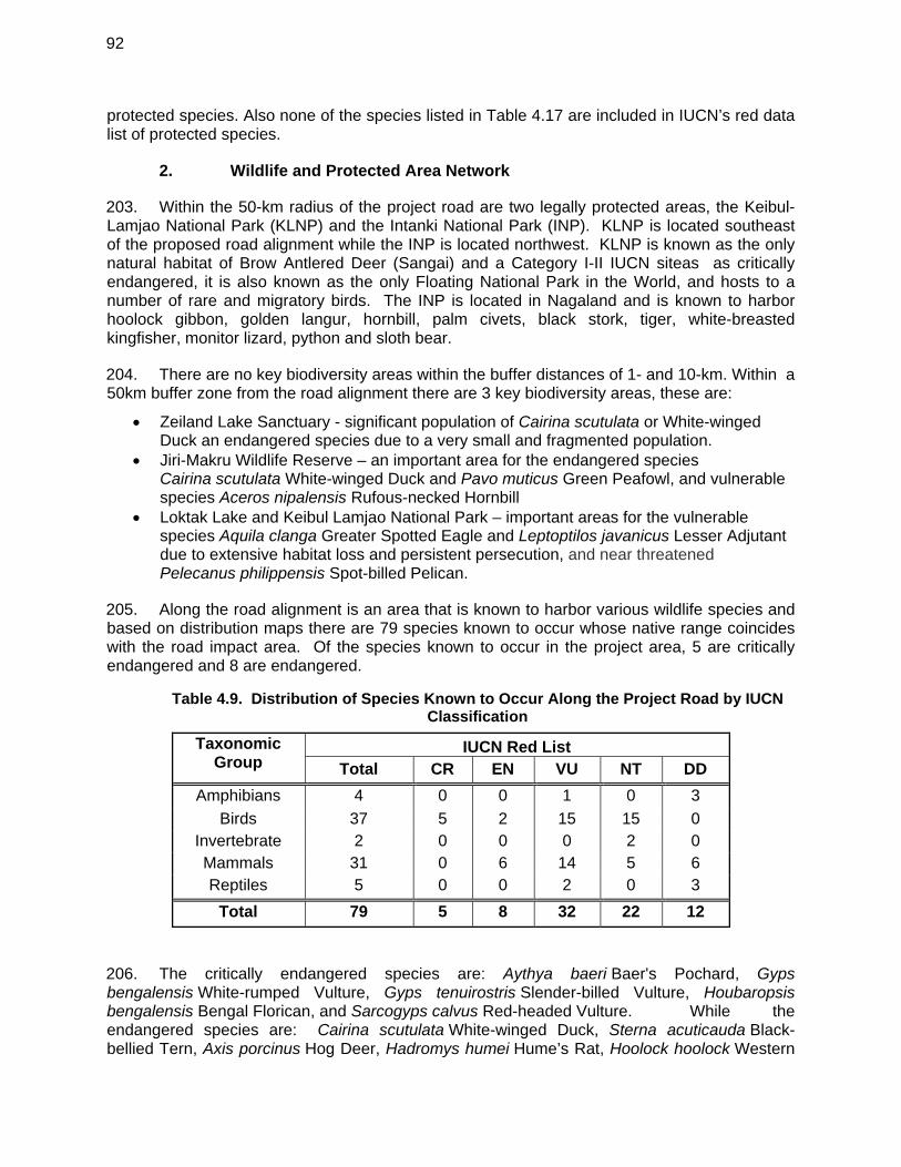
92
protected species. Also none of the species listed in Table 4.17 are included in IUCN’s red data list of protected species.
2. Wildlife and Protected Area Network
203. Within the 50-km radius of the project road are two legally protected areas, the Keibul-Lamjao National Park (KLNP) and the Intanki National Park (INP). KLNP is located southeast of the proposed road alignment while the INP is located northwest. KLNP is known as the only natural habitat of Brow Antlered Deer (Sangai) and a Category I-II IUCN siteas as critically endangered, it is also known as the only Floating National Park in the World, and hosts to a number of rare and migratory birds. The INP is located in Nagaland and is known to harbor hoolock gibbon, golden langur, hornbill, palm civets, black stork, tiger, white-breasted kingfisher, monitor lizard, python and sloth bear.
204. There are no key biodiversity areas within the buffer distances of 1- and 10-km. Within a 50km buffer zone from the road alignment there are 3 key biodiversity areas, these are:
Zeiland Lake Sanctuary - significant population of Cairina scutulata or White-winged Duck an endangered species due to a very small and fragmented population.
Jiri-Makru Wildlife Reserve – an important area for the endangered species Cairina scutulata White-winged Duck and Pavo muticus Green Peafowl, and vulnerable species Aceros nipalensis Rufous-necked Hornbill
Loktak Lake and Keibul Lamjao National Park – important areas for the vulnerable species Aquila clanga Greater Spotted Eagle and Leptoptilos javanicus Lesser Adjutant due to extensive habitat loss and persistent persecution, and near threatened Pelecanus philippensis Spot-billed Pelican.
205. Along the road alignment is an area that is known to harbor various wildlife species and based on distribution maps there are 79 species known to occur whose native range coincides with the road impact area. Of the species known to occur in the project area, 5 are critically endangered and 8 are endangered.
Table 4.9. Distribution of Species Known to Occur Along the Project Road by IUCN Classification
Taxonomic Group
IUCN Red List Total CR EN VU NT DD
Amphibians 4 0 0 1 0 3
Birds 37 5 2 15 15 0 Invertebrate 2 0 0 0 2 0 Mammals 31 0 6 14 5 6 Reptiles 5 0 0 2 0 3
Total 79 5 8 32 22 12
206. The critically endangered species are: Aythya baeri Baer's Pochard, Gyps bengalensis White-rumped Vulture, Gyps tenuirostris Slender-billed Vulture, Houbaropsis bengalensis Bengal Florican, and Sarcogyps calvus Red-headed Vulture. While the endangered species are: Cairina scutulata White-winged Duck, Sterna acuticauda Black-bellied Tern, Axis porcinus Hog Deer, Hadromys humei Hume’s Rat, Hoolock hoolock Western
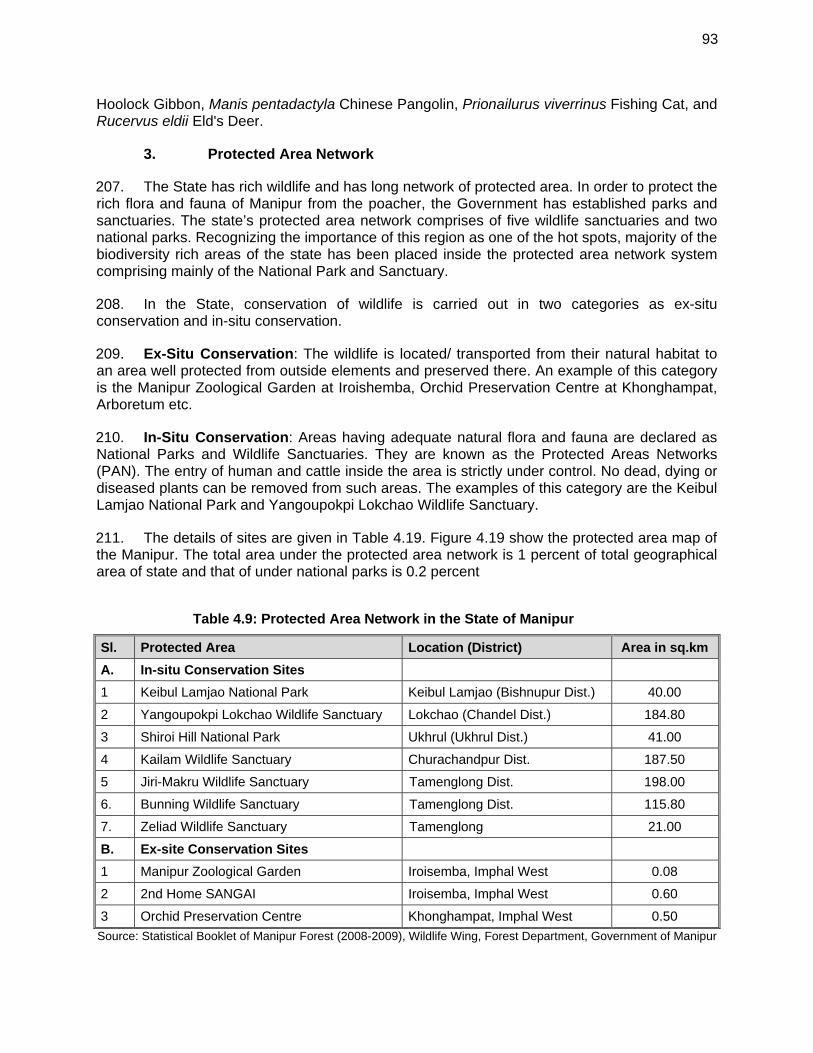
93
Hoolock Gibbon, Manis pentadactyla Chinese Pangolin, Prionailurus viverrinus Fishing Cat, and Rucervus eldii Eld's Deer.
3. Protected Area Network
207. The State has rich wildlife and has long network of protected area. In order to protect the rich flora and fauna of Manipur from the poacher, the Government has established parks and sanctuaries. The state’s protected area network comprises of five wildlife sanctuaries and two national parks. Recognizing the importance of this region as one of the hot spots, majority of the biodiversity rich areas of the state has been placed inside the protected area network system comprising mainly of the National Park and Sanctuary.
208. In the State, conservation of wildlife is carried out in two categories as ex-situ conservation and in-situ conservation.
209. Ex-Situ Conservation: The wildlife is located/ transported from their natural habitat to an area well protected from outside elements and preserved there. An example of this category is the Manipur Zoological Garden at Iroishemba, Orchid Preservation Centre at Khonghampat, Arboretum etc.
210. In-Situ Conservation: Areas having adequate natural flora and fauna are declared as National Parks and Wildlife Sanctuaries. They are known as the Protected Areas Networks (PAN). The entry of human and cattle inside the area is strictly under control. No dead, dying or diseased plants can be removed from such areas. The examples of this category are the Keibul Lamjao National Park and Yangoupokpi Lokchao Wildlife Sanctuary.
211. The details of sites are given in Table 4.19. Figure 4.19 show the protected area map of the Manipur. The total area under the protected area network is 1 percent of total geographical area of state and that of under national parks is 0.2 percent
Table 4.9: Protected Area Network in the State of Manipur
Sl. Protected Area Location (District) Area in sq.km
A. In-situ Conservation Sites
1 Keibul Lamjao National Park Keibul Lamjao (Bishnupur Dist.) 40.00
2 Yangoupokpi Lokchao Wildlife Sanctuary Lokchao (Chandel Dist.) 184.80
3 Shiroi Hill National Park Ukhrul (Ukhrul Dist.) 41.00
4 Kailam Wildlife Sanctuary Churachandpur Dist. 187.50
5 Jiri-Makru Wildlife Sanctuary Tamenglong Dist. 198.00
6. Bunning Wildlife Sanctuary Tamenglong Dist. 115.80
7. Zeliad Wildlife Sanctuary Tamenglong 21.00
B. Ex-site Conservation Sites
1 Manipur Zoological Garden Iroisemba, Imphal West 0.08
2 2nd Home SANGAI Iroisemba, Imphal West 0.60
3 Orchid Preservation Centre Khonghampat, Imphal West 0.50
Source: Statistical Booklet of Manipur Forest (2008-2009), Wildlife Wing, Forest Department, Government of Manipur
94
212. In the state, in spite of its rich vegetation, due to the absence of any forest worth the name within the district wild animals are not found abundantly, Deer and Jungle fowl are some of the varieties found at present occasionally along the slope of eastern hills adjoining the district. But the lakes support a variety of wild birds such as partridge, snipe, duck, geese, etc. particularly in winter months. These birds are mostly migratory in character. Some of them are seen coming from far off Siberia. With the gradual conversation of the lakes into agricultural lands these migratory birds are seen in increasingly fewer members in recent times.
213. It can be seen from the map (figure 4.19) that the project section sections Imphal to Kangchup and Kangchup to Tamenglong, neither encroaches nor passes by any of the protected areas of Manipur. However, the section in Songlong village boundary passes through Kangchup-Makang Reserve Forest. Pocket of forests area is from chainage km 26.0 to 32.0 for this section.
214. Informal interviews were held with the local villagers, livestock herders to gather information on the presence of wildlife and their habitats along the project rods. Officials from Wildlife division including Chief Wildlife Warden and Chief Conservator of Forests were also consulted in the process. Office of the Chief Conservator (Widlife) informed that there are no protected area along the proposed alignment of the Imphal-Tamenglong Road Section.
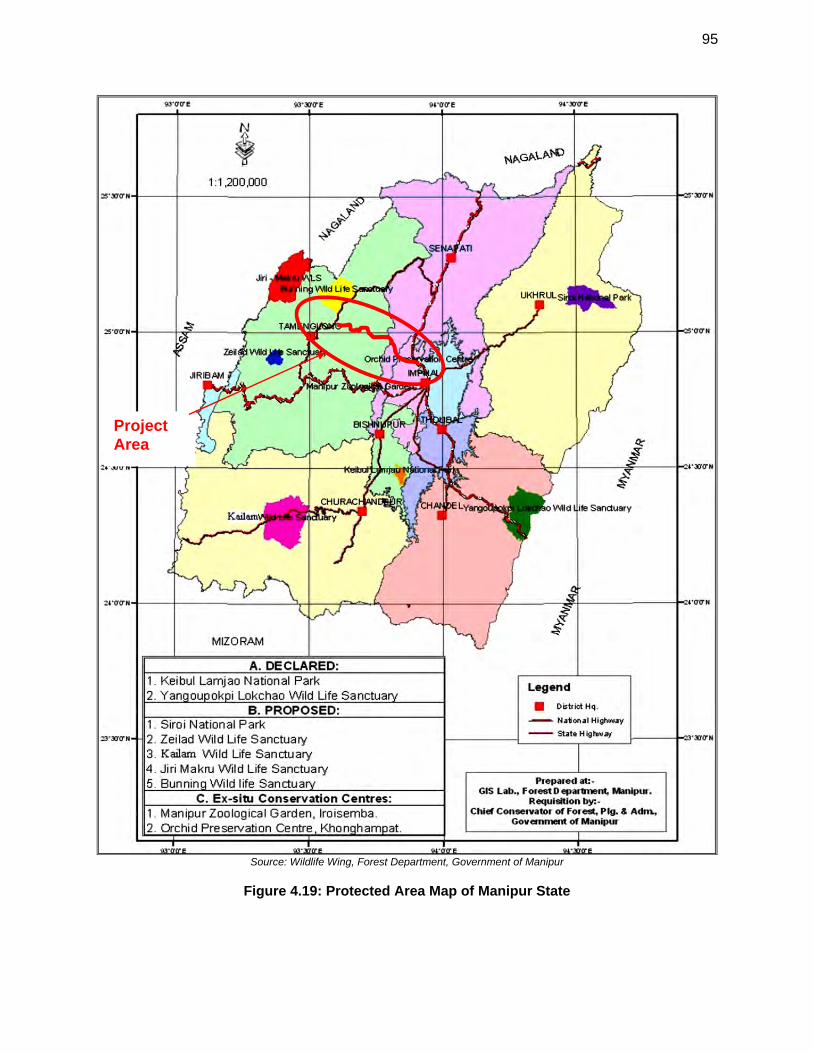
95
Source: Wildlife Wing, Forest Department, Government of Manipur
Figure 4.19: Protected Area Map of Manipur State
Project Area
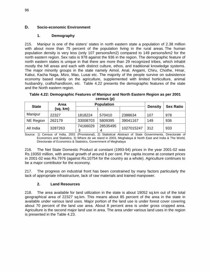
96
D. Socio-economic Environment
1. Demography
215. Manipur is one of the sisters’ states in north eastern state a population of 2.38 million with about more than 75 percent of the population living in the rural areas. The human population density is very less (only 107 persons/km2) compared to 149 persons/km2 for the north eastern region. Sex ratio is 978 against the 936 in the region. The demographic feature of north eastern states is unique in that there are more than 29 recognized tribes, which inhabit mostly the hill areas and each with distinct culture, ethos, and traditional knowledge systems. The major minority groups in the state namely Aimol, Anal, Angami, Chiru, Chothe, Hmar, Kabui, Kacha Naga, Mizo, Mao, Lusai etc. The majority of the people survive on subsistence economy based mainly on the agriculture, supplemented with limited horticulture, animal husbandry, crafts/handloom, etc. Table 4.22 presents the demographic features of the state and the North eastern region.
Table 4.22: Demographic Features of Manipur and North Eastern Region as per 2001 census (p)
State Area
(sq. km) Population
Density Sex Ratio n
Manipur 22327 1818224 570410 2388634 107 978
NE Region 262179 33008703 5809395 39041167 149 936
All India 3287263 741660293
285354954
1027015247 312 933
Source: 1) Census of India, 2001 (Provisional), 2) Statistical Abstract of State Governments, Directorate of Economics and Statistics, 3) Where do we stand in 2003, Meghalaya & North East and India & The World, Directorate of Economics & Statistics, Government of Meghalaya
216. The Net State Domestic Product at constant (1993-94) prices in the year 2001-02 was Rs.19350 million, with annual growth of around 6 per cent. Per capita income at constant prices in 2001-02 was Rs.7976 (against Rs.10754 for the country as a whole). Agriculture continues to be a major contributor for the economy.
217. The progress on industrial front has been constrained by many factors particularly the lack of appropriate infrastructure, lack of raw materials and trained manpower.
2. Land Resources
218. The area available for land utilization in the state is about 19052 sq.km out of the total geographical area of 22327 sq.km. This means about 85 percent of the area in the state in available under various land uses. Major portion of the land use is under forest cover covering about 70 percent of the land use area. About 8 percent area is under gross cropped area. Agriculture is the second major land use in area. The area under various land uses in the region is presented in the Table 4.23.
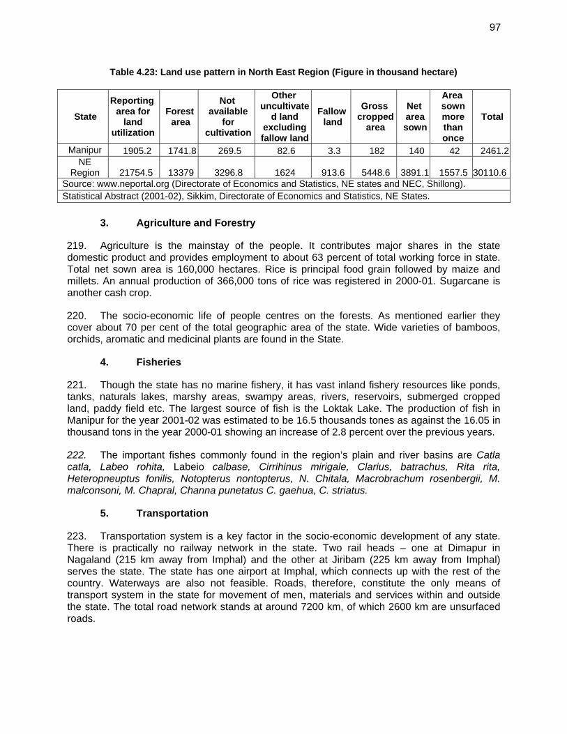
97
Table 4.23: Land use pattern in North East Region (Figure in thousand hectare)
State
Reporting area for
land utilization
Forest area
Not available
for cultivation
Other uncultivate
d land excluding fallow land
Fallow land
Gross cropped
area
Net area sown
Area sown more than once
Total
Manipur 1905.2 1741.8 269.5 82.6 3.3 182 140 42 2461.2NE
Region 21754.5 13379 3296.8 1624 913.6 5448.6 3891.1 1557.5 30110.6Source: www.neportal.org (Directorate of Economics and Statistics, NE states and NEC, Shillong). Statistical Abstract (2001-02), Sikkim, Directorate of Economics and Statistics, NE States.
3. Agriculture and Forestry
219. Agriculture is the mainstay of the people. It contributes major shares in the state domestic product and provides employment to about 63 percent of total working force in state. Total net sown area is 160,000 hectares. Rice is principal food grain followed by maize and millets. An annual production of 366,000 tons of rice was registered in 2000-01. Sugarcane is another cash crop.
220. The socio-economic life of people centres on the forests. As mentioned earlier they cover about 70 per cent of the total geographic area of the state. Wide varieties of bamboos, orchids, aromatic and medicinal plants are found in the State.
4. Fisheries
221. Though the state has no marine fishery, it has vast inland fishery resources like ponds, tanks, naturals lakes, marshy areas, swampy areas, rivers, reservoirs, submerged cropped land, paddy field etc. The largest source of fish is the Loktak Lake. The production of fish in Manipur for the year 2001-02 was estimated to be 16.5 thousands tones as against the 16.05 in thousand tons in the year 2000-01 showing an increase of 2.8 percent over the previous years.
222. The important fishes commonly found in the region’s plain and river basins are Catla catla, Labeo rohita, Labeio calbase, Cirrihinus mirigale, Clarius, batrachus, Rita rita, Heteropneuptus fonilis, Notopterus nontopterus, N. Chitala, Macrobrachum rosenbergii, M. malconsoni, M. Chapral, Channa punetatus C. gaehua, C. striatus.
5. Transportation
223. Transportation system is a key factor in the socio-economic development of any state. There is practically no railway network in the state. Two rail heads – one at Dimapur in Nagaland (215 km away from Imphal) and the other at Jiribam (225 km away from Imphal) serves the state. The state has one airport at Imphal, which connects up with the rest of the country. Waterways are also not feasible. Roads, therefore, constitute the only means of transport system in the state for movement of men, materials and services within and outside the state. The total road network stands at around 7200 km, of which 2600 km are unsurfaced roads.
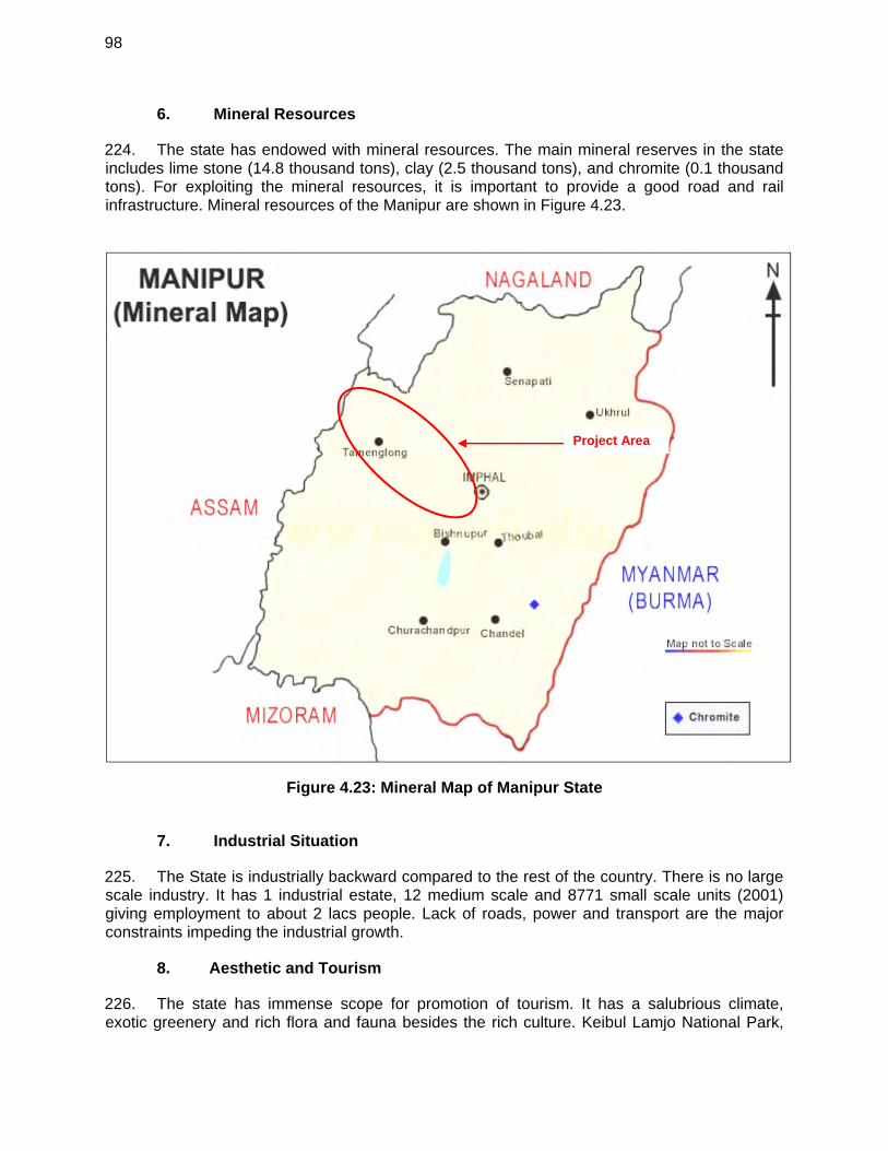
98
6. Mineral Resources
224. The state has endowed with mineral resources. The main mineral reserves in the state includes lime stone (14.8 thousand tons), clay (2.5 thousand tons), and chromite (0.1 thousand tons). For exploiting the mineral resources, it is important to provide a good road and rail infrastructure. Mineral resources of the Manipur are shown in Figure 4.23.
Figure 4.23: Mineral Map of Manipur State
7. Industrial Situation
225. The State is industrially backward compared to the rest of the country. There is no large scale industry. It has 1 industrial estate, 12 medium scale and 8771 small scale units (2001) giving employment to about 2 lacs people. Lack of roads, power and transport are the major constraints impeding the industrial growth.
8. Aesthetic and Tourism
226. The state has immense scope for promotion of tourism. It has a salubrious climate, exotic greenery and rich flora and fauna besides the rich culture. Keibul Lamjo National Park,
Project Area
99
the only habitat of Brow Antlered Deer, on the bank of Loktak Lake (the biggest fresh water lake in north eastern India), Khongjom War Memorial are few major tourist spots in the region. During the year 2001, 409 foreign tourists and 10385 thousands of domestic tourists came to the state. The state offers unique opportunity for eco-tourism development.
9. Cultural Resources
227. The state has great cultural value. Festivals and cultural activities are being celebrated throughout the year in the state. The department of arts and cultural has taken various activities like promotion of art and culture, preservation of old and historical monuments. The state has great cultural value for Buddhism. To promote and preserve the rich cultural heritage of the state, the department has been organising a number of programmes annually.
10. Energy and Electric Power Potential
228. The state has an installed capacity of 117 MW of power including the power from central sector. It is just able to meet the current demand. With increase in socio-economic development, more power will be required. It is, therefore, necessary to increase power availability in the state.
11. International Trade & Commerce
229. The north eastern region has the potential to emerge as a strategic base for domestic and foreign investors to tap the potential of the contiguous markets of China, Myanmar, Lao PDR, Nepal, Bhutan and Tibet. This calls for converting the unauthorised trade into authorised trade, at the policy level as well as at the ground level. The BIMST-EC (Bangladesh-India-Myanmar-Sri Lanka-Thailand Economic Cooperation) initiative is creating an enabling environment for rapid economic development through identification and implementation of specific cooperation projects in the sectors of trade, investment and industry, technology, human resource development, tourism, agriculture, energy, infrastructure and transportation.
12. Hotspots along the Project Road
230. Inventory of various physical features existing along the project road has been carried out as presented in Table 3.25. This also includes information about physical features, sensitive zones, sinking areas etc.
231. The various physical features along the project road are described in Table 4.24.
Table 4.24: Physical /Sensitive Features along the project road
Location / Chainage (Km)
Features
1-5 Urban - Imphal City, residential settlement continues along the road & commercial area , Plain terrain, River Crossing
5-12 Semi-urban & Rural, Agriculture mixed with residential & commercial landuse at village Lamdeng, Lamsang, Heibong, Lairenkabi, Plain Terrain
12-15 Rural, Agriculture mixed with residential & commercial landuse at village Phaiyeng, Kangchup, Plain Terrain
15-19.8 Rural, Agriculture mixed with forest & residential landuse, village Kangchup Chiru, Hilly Terrain, Stream along the alignment
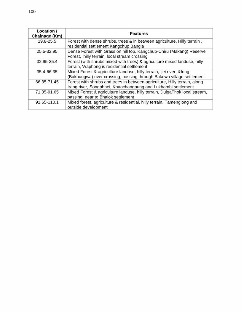
100
Location / Chainage (Km)
Features
19.8-25.5 Forest with dense shrubs, trees & in between agriculture, Hilly terrain , residential settlement Kangchup Bangla
25.5-32.95 Dense Forest with Grass on hill top, Kangchup-Chiru (Makang) Reserve Forest, hilly terrain, local stream crossing
32.95-35.4 Forest (with shrubs mixed with trees) & agriculture mixed landuse, hilly terrain, Waphong is residential settlement
35.4-66.35 Mixed Forest & agriculture landuse, hilly terrain, Ijei river, &Iring (Bakhungwa) river crossing, passing through Bakuwa village settlement
66.35-71.45 Forest with shrubs and trees in between agriculture, Hilly terrain, along Irang river, Songphhei, Khaochangpung and Lukhambi settlement
71.35-91.65 Mixed Forest & agriculture landuse, hilly terrain, DuigaThok local stream, passing near to Bhalok settlement
91.65-110.1 Mixed forest, agriculture & residential, hilly terrain, Tamenglong and outside development
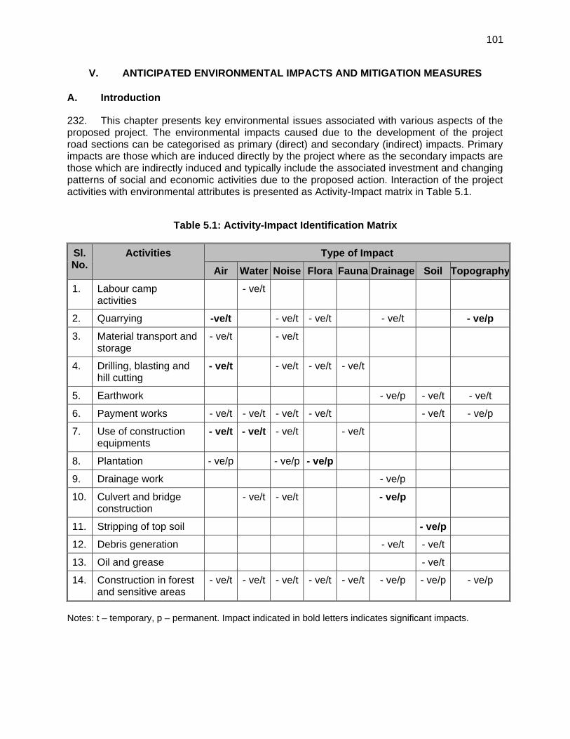
101
V. ANTICIPATED ENVIRONMENTAL IMPACTS AND MITIGATION MEASURES
A. Introduction
232. This chapter presents key environmental issues associated with various aspects of the proposed project. The environmental impacts caused due to the development of the project road sections can be categorised as primary (direct) and secondary (indirect) impacts. Primary impacts are those which are induced directly by the project where as the secondary impacts are those which are indirectly induced and typically include the associated investment and changing patterns of social and economic activities due to the proposed action. Interaction of the project activities with environmental attributes is presented as Activity-Impact matrix in Table 5.1.
Table 5.1: Activity-Impact Identification Matrix
Sl. No.
Activities Type of Impact
Air Water Noise Flora Fauna Drainage Soil Topography
1. Labour camp activities
- ve/t
2. Quarrying -ve/t - ve/t - ve/t - ve/t - ve/p
3. Material transport and storage
- ve/t - ve/t
4. Drilling, blasting and hill cutting
- ve/t - ve/t - ve/t - ve/t
5. Earthwork - ve/p - ve/t - ve/t
6. Payment works - ve/t - ve/t - ve/t - ve/t - ve/t - ve/p
7. Use of construction equipments
- ve/t - ve/t - ve/t - ve/t
8. Plantation - ve/p - ve/p - ve/p
9. Drainage work - ve/p
10. Culvert and bridge construction
- ve/t - ve/t - ve/p
11. Stripping of top soil - ve/p
12. Debris generation - ve/t - ve/t
13. Oil and grease - ve/t
14. Construction in forest and sensitive areas
- ve/t - ve/t - ve/t - ve/t - ve/t - ve/p - ve/p - ve/p
Notes: t – temporary, p – permanent. Impact indicated in bold letters indicates significant impacts.
102
233. Identification and assessment of the potential environmental impacts are based on secondary information supplemented by field visits. Impacts on various environmental components have been assessed at four different stages, namely:
the project location; design and pre-construction; construction; and operation stages.
234. A few permanent as well as short-term and long-term adverse effects, mainly at the construction and operation stages, are, nonetheless, anticipated. Temporarty shortl term impacts can be kept in check through proper planning and adopting environment friendly road construction methods and the appropriate regulatory measures. B. Positive Environmental Impacts due to improvement of subproject road sections
235. The positive impacts expected from the improvement of the Imphal-Kanchup-Tamenglong road section includes:
improved quality of life for the rural population in the project influence: this as a result of better access to markets, health, education and other facilities; and the derived stimulus for local economic activity;
a more efficient and safe road transport system: through reduced travel times, reduced road accidents, reduced vehicle operating and maintenance costs and reduced transportation costs for goods;
the facilitation of tourism; Reduced distance to Guwahati, the commercial hub of the North East, from Imphal
by at least 90 (ninety) Kms as compared to the existing route via Dimapur; Interstate connectivity to Imphal and Tamenglong Districts; Shortest connectivity for the State to East West Corridor of National Highways
Authority of India, and Connectivity to the Asian Highway network.
C. Adverse Environmental Impacts due to improvement of subproject road sections
236. The adverse environmental impacts anticipated from the improvement of the project road section are:
Change in topography and land use due to acquisition of land for new alignment Loss of productive soil and agriculture land, Cutting of road side trees that falls within formation width i.e. 10-30 m may reduce
the ecological balance of the area and also increase soil erosion problem. Noise, air and water pollution and disposal of construction waste, during
construction, will adversely impact both local residents. These latter effects should, however, only be temporary/reversible.
A number of quarries and other sources will be established which will change the landscape. However, the operation of quarries is an independent and already regulated activity. Adverse impacts on water quality of rivers crossing or running parellel to the proposed alignment (i.e. Ijai at chainage km 35.2, Iring at km 52.2 and again at km75.5, Duiga at km 71.2 and again at km 71.1, other local stream/rivers) in
103
the form of silt deposition and runoff during construction are expected. However, this is short term and will be taken care of by controlled construction activities.
Improvement on existing road and construction of new road and bridges, although limited, may enhance soil erosion, landslips and reduce the micro-level ecological balance of the area. Construction may also disturb the habitation of fauna living in this area. These should, however, be only temporary/reversible effects. The improvement will also require the cutting of about 2732 trees.
Minor impacts of noise and air quality for those now living and workings close to the project road (mainly at Imphal, Kanchup, and Tamenglong) will deteriorate during the construction period and afterwards during operation.
D. Impacts Related to Project Location, Preliminary Planning and Design
1. Land Acquisition and Loss of Productive Land
237. Except intial 15 km section, project road alignment will pass through hilly terrain and it is a greenfield alignment which would require construction of new roads. This will require acquisition of about 291 hectare (30 m ROW for 97 km length) of land for road right of way. Although land acquisition requirement has been kept to minimum level, it will have impacts on topography and change in land use in the region. Loss of agriculture land and productive soil is also anticipated due to additional land acqusition. To minimize land acquisition and soil productivity, the following mitigation measures have been /will be adopted during the detailed design and construction stage of the project:
Alignment will be adjusted to avoid and minimize acquisition Topsoil management during construction. Use of existing tracks to the extent possible.
2. Forest Clearing and Tree Felling
238. Most of the project road (except Imphal to Kanchup section) passes though hilly terrain with patches of forest areas. About 6 km length of subproject road passes through Kanchup reserve forest area. Adverse impacts due to diversion of about 18 hectares of forest land are anticipated. Also land clearing will involve cutting of about 2732 trees. Problem of soil erosion is expected in some locations. To minimize loss of trees, the following mitigation measures have been /will be adopted during the detailed design and construction stage of the project:
Widening proposal considered option with minimal tree cutting. Widening is restricted to minimum width in the length passing through forest areas. Adequate measures are included in the design to minimize any unforeseen impacts
on flora and fauna in the forest areas. Land stabilization measures were included in identified areas prone to erosion. strictly enforce the environmental conditions put as part of the environmental
clearance by the MoEF and SPCB. adopting Environmental Friendly Road Construction (EFRC) methods.
239. The improvement of the proposed road in greenfield area willl involve cutting, filling, and the need to cut vegetation along most of the project road length. This will have more significant impact and this matter is discussed in the following sections.
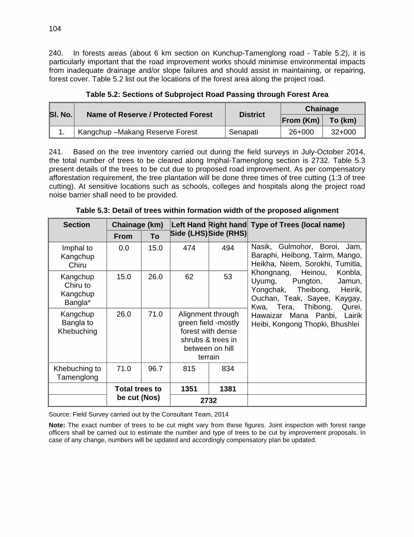
104
240. In forests areas (about 6 km section on Kunchup-Tamenglong road - Table 5.2), it is particularly important that the road improvement works should minimise environmental impacts from inadequate drainage and/or slope failures and should assist in maintaining, or repairing, forest cover. Table 5.2 list out the locations of the forest area along the project road.
Table 5.2: Sections of Subproject Road Passing through Forest Area
Sl. No. Name of Reserve / Protected Forest District Chainage
From (Km) To (km)
1. Kangchup –Makang Reserve Forest Senapati 26+000 32+000
241. Based on the tree inventory carried out during the field surveys in July-October 2014, the total number of trees to be cleared along Imphal-Tamenglong section is 2732. Table 5.3 present details of the trees to be cut due to proposed road improvement. As per compensatory afforestation requirement, the tree plantation will be done three times of tree cutting (1:3 of tree cutting). At sensitive locations such as schools, colleges and hospitals along the project road noise barrier shall need to be provided.
Table 5.3: Detail of trees within formation width of the proposed alignment
Section Chainage (km) Left Hand Side (LHS)
Right hand Side (RHS)
Type of Trees (local name)
From To
Imphal to Kangchup
Chiru
0.0 15.0 474 494 Nasik, Gulmohor, Boroi, Jam, Baraphi, Heibong, Tairm, Mango, Heikha, Neem, Sorokhi, Tumitla, Khongnang, Heinou, Konbla, Uyumg, Pungton, Jamun, Yongchak, Theibong, Heirik, Ouchan, Teak, Sayee, Kaygay, Kwa, Tera, Thibong, Qurei, Hawaizar Mana Panbi, Lairik Heibi, Kongong Thopki, Bhushlei
Kangchup Chiru to
Kangchup Bangla*
15.0 26.0 62 53
Kangchup Bangla to
Khebuching
26.0 71.0 Alignment through green field -mostly forest with dense shrubs & trees in between on hill
terrain
Khebuching to Tamenglong
71.0 96.7 815 834
Total trees to be cut (Nos)
1351 1381
2732
Source: Field Survey carried out by the Consultant Team, 2014
Note: The exact number of trees to be cut might vary from these figures. Joint inspection with forest range officers shall be carried out to estimate the number and type of trees to be cut by improvement proposals. In case of any change, numbers will be updated and accordingly compensatory plan be updated.
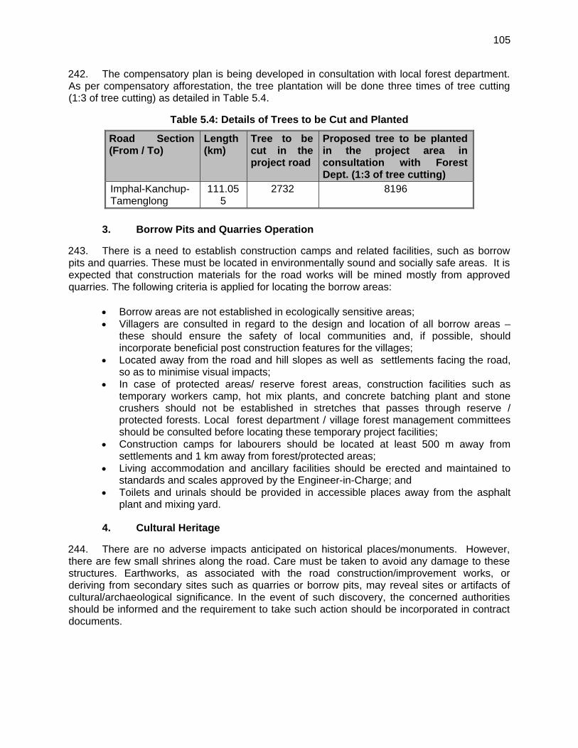
105
242. The compensatory plan is being developed in consultation with local forest department. As per compensatory afforestation, the tree plantation will be done three times of tree cutting (1:3 of tree cutting) as detailed in Table 5.4.
Table 5.4: Details of Trees to be Cut and Planted
Road Section (From / To)
Length (km)
Tree to be cut in the project road
Proposed tree to be planted in the project area in consultation with Forest Dept. (1:3 of tree cutting)
Imphal-Kanchup-Tamenglong
111.055
2732 8196
3. Borrow Pits and Quarries Operation
243. There is a need to establish construction camps and related facilities, such as borrow pits and quarries. These must be located in environmentally sound and socially safe areas. It is expected that construction materials for the road works will be mined mostly from approved quarries. The following criteria is applied for locating the borrow areas:
Borrow areas are not established in ecologically sensitive areas; Villagers are consulted in regard to the design and location of all borrow areas –
these should ensure the safety of local communities and, if possible, should incorporate beneficial post construction features for the villages;
Located away from the road and hill slopes as well as settlements facing the road, so as to minimise visual impacts;
In case of protected areas/ reserve forest areas, construction facilities such as temporary workers camp, hot mix plants, and concrete batching plant and stone crushers should not be established in stretches that passes through reserve / protected forests. Local forest department / village forest management committees should be consulted before locating these temporary project facilities;
Construction camps for labourers should be located at least 500 m away from settlements and 1 km away from forest/protected areas;
Living accommodation and ancillary facilities should be erected and maintained to standards and scales approved by the Engineer-in-Charge; and
Toilets and urinals should be provided in accessible places away from the asphalt plant and mixing yard.
4. Cultural Heritage
244. There are no adverse impacts anticipated on historical places/monuments. However, there are few small shrines along the road. Care must be taken to avoid any damage to these structures. Earthworks, as associated with the road construction/improvement works, or deriving from secondary sites such as quarries or borrow pits, may reveal sites or artifacts of cultural/archaeological significance. In the event of such discovery, the concerned authorities should be informed and the requirement to take such action should be incorporated in contract documents.

106
5. Other Impacts deriving from the Project Planning and Design Process
245. During preliminary planning and design of this project, the Consultant has taken into account the need for:
optimum sitting and control of borrow areas; reduced incidence of slope failures due to inadequate drainage; providing adequate culverts/drains; providing side-drainage structures; mechanised construction methods and thereby, for example, reduced use of
firewood for heating bitumen; maximising safety and thereby reducing traffic accidents; reducing travel times and, thereby, fuel consumption and emissions; adequate signages for wildlife protections, increased accessibility for residents to education and health facilities, markets etc.,
and for others who might come for tourist or other purposes; and improving the socio-economic conditions of residents in the project areas of
influence. 246. As part of the engineering works for this work, the following guiding principles have been used in determining the alignments: Environmental Issue Measures taken
Alignment Final alignment has been determined so as to minimise land take, tree removal, air pollution and the impact on people and animals and to avoid unfavourable geological condition and cultural relics.
Balancing cut and fill The design attempted to equalise cut and fill. The centreline has been aligned so that on all slopes below 60 degrees, half cut and half fill is achieved.
Soil erosion Temporary and permanent drainage systems have been designed to minimise the soil erosion.
Dust and air pollution Borrow sites, waste disposal sites and asphalt mixing sites have been identified – keeping in mind environmental issues such as dust.
Cultural heritage Any archaeological sites identified along the alignment should be excavated prior to construction.
Wildlife Habitat Care has been taken in preservation of wildlife and construction workers should be educated on wildlife protection.
E. Environmental Impacts - Construction Stage
1. Permits and Clearances
247. As a requirement of Environmental Impact Assessment Notification, 2006, by Government of India, any development activities should not be taken in any part of the Country unless it has granted environmental clearance by the Ministry of Environment and Forests, Government of India.
107
248. Highways are classified as one of the project, listed in said notification, which require prior clearance. However, an amendment to this notification clarifies, that the highway improvement projects are excluded from purview of this notification. Some of the relevant applicable sections are:
(i) Although the proposed project interventions are primerly limited to the improvement of exisiting state highway section and village/districts roads/tracks and the alignment does not pass through any environmentally sensitive areas, part of the project road between Kanchup and Tamenglong is located at an altitude of > 1000 m above MSL. Therefore it falls in the purview of Notification no. S.O. 195(E) dated 19 January 2009 by the Ministry of Environment and Forests on amendment to the EIA Notification, which states that ‘All State Highway projects and State Highway expansion projects in hilly terrain or in ecologically sensitive areas” need to get environmental clearance prior to construction activities. It is further defined that hilly terrain is defined as ‘All projects located at altitude of 1000 meter and above’. Accordingly, for the proposed road improvement project, implementing authority has to apply for environmental clearance from the State Level Environmental Impact Assessment Authority (SEIAA).
(ii) As per the Forest Conservation Rules (1981, amended 2003) a forestry clearance from Department of Forests is required for diversion of forest land for non-forest purpose. Processing of the forestry clearance entails two stages: stage I and stage II. Amongst other requirements stage I clearance requires the applicant to make payments for compensation of forestry land that will be acquired and trees that will be cut under the project. Accordingly timely allocation of budget for this purpose by the applicant is necessary to expedite the clearance process.
(iii) Cutting of trees in non forest land require a tree cutting permit from the local forestry
department. All trees cut under a project must be compensated by compensatory afforestation as required by the Forest Department.
(iv) As per Office Memorandum (OM) issued by MOEF on 19 March 2013 the grant of
environmental clearance for linear projects including roads has been delinked from the forestry clearance procedure. Hence, after receipt of environmental clearance construction works may commence on sections/parts of a linear project that do not require forestry clearance. Construction works may commence on sections requiring forestry clearance only after receipt of the respective clearance.
(v) Placement of hot-mix plants, quarrying and crushers, batch mixing plants, discharge of sewage from construction camps requires No Objection Certificate (Consent to Establish and Consent to Operate) from State Pollution Control Board prior to establishment.
(vi) Permission from Central Ground Water Authority is required for extracting ground water for construction purposes, from areas declared as critical or semi critical from ground water potential prospective by them.
249. Before the start of civil works for any section of subproject the project proponent (State PWD) must obtain necessary clearances / permits from the regional office of the Ministry of Environment and Forests and State Pollution Control Board. Table 5.5 outlines the applicable
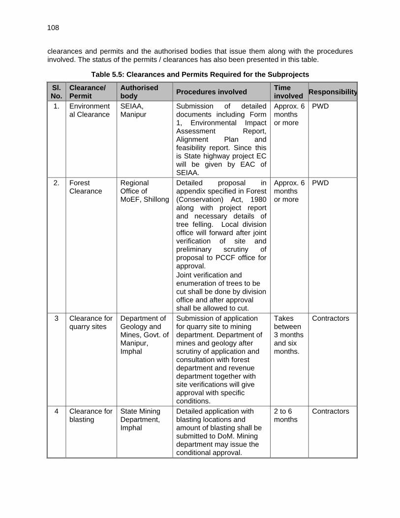
108
clearances and permits and the authorised bodies that issue them along with the procedures involved. The status of the permits / clearances has also been presented in this table.
Table 5.5: Clearances and Permits Required for the Subprojects
Sl. No.
Clearance/ Permit
Authorised body
Procedures involved Time involved
Responsibility
1. Environmental Clearance
SEIAA, Manipur
Submission of detailed documents including Form 1, Environmental Impact Assessment Report, Alignment Plan and feasibility report. Since this is State highway project EC will be given by EAC of SEIAA.
Approx. 6 months or more
PWD
2. Forest Clearance
Regional Office of MoEF, Shillong
Detailed proposal in appendix specified in Forest (Conservation) Act, 1980 along with project report and necessary details of tree felling. Local division office will forward after joint verification of site and preliminary scrutiny of proposal to PCCF office for approval. Joint verification and enumeration of trees to be cut shall be done by division office and after approval shall be allowed to cut.
Approx. 6 months or more
PWD
3 Clearance for quarry sites
Department of Geology and Mines, Govt. of Manipur, Imphal
Submission of application for quarry site to mining department. Department of mines and geology after scrutiny of application and consultation with forest department and revenue department together with site verifications will give approval with specific conditions.
Takes between 3 months and six months.
Contractors
4 Clearance for blasting
State Mining Department, Imphal
Detailed application with blasting locations and amount of blasting shall be submitted to DoM. Mining department may issue the conditional approval.
2 to 6 months
Contractors
109
250. Any felling of trees requires forestry clearance and appropriate permits. The procedures necessary to obtain such permits will require liaison with local territorial forestry offices and their head office in Imphal. Joint verification and making of trees to be cut is being carried out jointly with divisional forest departments of districts involved. No clearance is required for the use of surface sand and stone from the river banks as for commercial purposes they can only be purchased in an open auction carried out by the forestry office. It is imperative that all necessary clearances and permits be obtained before commencement of work.
2. Physical Environment
a. Topography, Geology and Soil
251. During the improvement works for the road section, the cutting of hill slope, filling, the cutting of trees, stone quarrying, and construction of structures, the micro-level topography may change. With proper planning, these topographical impacts can be kept within acceptable limits and sometimes even used to enhance local aesthetics. Any negative impacts on topography (existing or new), particularly soil erosion due to a lack of drainage facilities, will be minimised with the provision of proper drainage facilities such as culverts, causeways etc. 252. The terrain and geological conditions of area are such that, even with reasonable care exercised during final design, during construction the interaction between proposed road features and existing land features may reveal/result in significant land instabilities. 253. During the construction phase following restrictions should be imposed:
existing vegetation including shrubs and grasses along the road (except within the strip directly under embankments or cuttings) should be properly maintained;
sites for quarrying, borrowing and disposal of spoils are to be confirmed according to the applicable laws and regulations in the state and the practices followed in recent/ongoing internationally funded road projects should be continued;
controlled and environmentally friendly quarrying techniques should be applied to minimise erosions and landslides;
blasting should not be carried out during busy periods; and cut material should be disposed of in suitable depressions.
254. It is also important to:
maintain adequate vegetative cover above and below the road; maintain the natural course of water bodies (that is as far as possible) and avoid
throwing debris into stream courses; construct proper drainage structures to avoid erosion; and minimise the construction of hair-pin bends that are close to each other: as this often
adds to instability. 255. Given the existence of high slope and high rainfall in almost entire project area and weak geology in some areas, it is inevitable that some sites will face problems of erosion, mostly debris slides.
110
b. Erosion, Silt Run-Off and Landslides
256. Contraction work in Kanchup to Tamenglong section of the project road will be virtually through mountainous terrain with steep and unstable slopes. Much of areas in this section are geologically young, resulting in soft/fragile substrates. Another complicating factor is the high monsoon rainfall throughout most parts of the project road. These factors mean that project area conditions are amongst the most difficult in the region for road construction. Landslides frequently caused by inappropriate construction techniques, slope instability, and inadequate drainage are major problems and are associated with all types of road construction. It should be noted that a significant number of landslides that occur in the vicinity of road are caused by factors/features only indirectly linked to the road itself – frequently, irrigation channels, logging, quarrying and cultivation practices. To control these, following measures are suggested by local environmental authorities:
logging immediately above road should be restricted to reduce erosion/landslide potential;
quarrying along road ROW should be restricted; excavated material should be properly disposed of and not simply dumped downhill; adequate reclamation (e.g. fertilisation and reseeding) along denuded ROW should
be implemented; particular care should be given to providing adequate drainage; careful supervision/training of blasting technicians is required; and to the largest extent possible, care should be taken to avoid sacred and religious
sites. 257. Previous studies by the Border Road Organisation and CRRI indicate the need to incorporate the following measures:
balance cut and fill: with a prohibition on the dumping of spoil over the road edge – thus minimising erosion;
more frequent use of retaining walls - to control landslips; improved drainage - again so that erosion is minimised; controlled blasting in rock-cut areas - to minimise erosion; and use of bioengineering technique for slope protection: use of native species of plants
and shrubs for slope stabilisation. 258. Unstable, uncompacted road embankment materials and exposed material can result to soil erosion, clogging of side drains and the spill-over of rainwater runoff onto the road surface and down slopes. These cause landslides and hinder traffic movement. These problems can be mitigated by maintaining the batter gradients as specified in the MoRTH guidelines. The existing vegetation on slopes outside the immediate area of construction must remain undisturbed during construction and/or upgrading. Bioengineering techniques will be used to prevent barren slopes and to stop soil erosion and to protect the animals from grazing animals. Support structures will be installed where slope failures are anticipated or may have occurred previously. Slope failures should be monitored and remedial actions initiated at the earliest possible time. 259. Construction involving rock/soil cutting of hillsides may render hill slopes unstable and increase vulnerability to landslides. Blasting of rocks may also result in landslides.
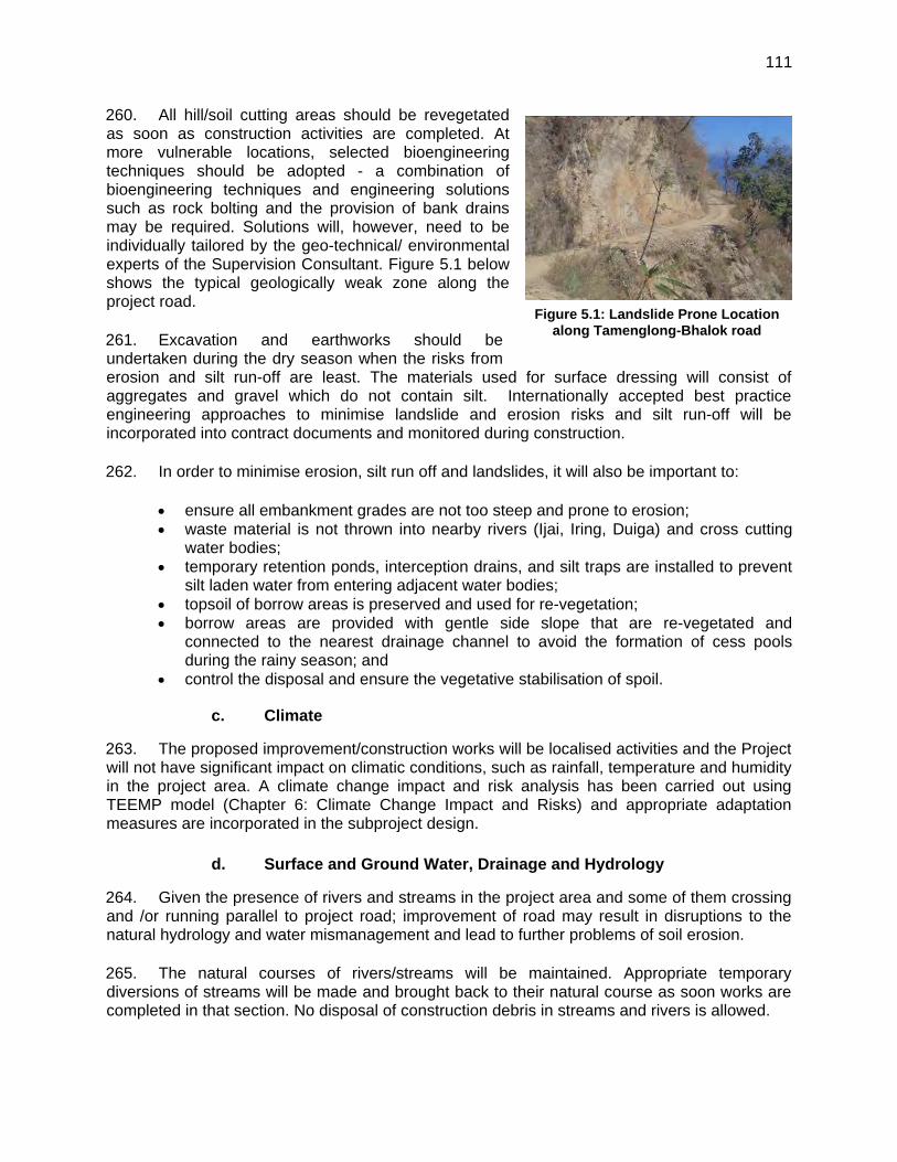
111
260. All hill/soil cutting areas should be revegetated as soon as construction activities are completed. At more vulnerable locations, selected bioengineering techniques should be adopted - a combination of bioengineering techniques and engineering solutions such as rock bolting and the provision of bank drains may be required. Solutions will, however, need to be individually tailored by the geo-technical/ environmental experts of the Supervision Consultant. Figure 5.1 below shows the typical geologically weak zone along the project road. 261. Excavation and earthworks should be undertaken during the dry season when the risks from erosion and silt run-off are least. The materials used for surface dressing will consist of aggregates and gravel which do not contain silt. Internationally accepted best practice engineering approaches to minimise landslide and erosion risks and silt run-off will be incorporated into contract documents and monitored during construction. 262. In order to minimise erosion, silt run off and landslides, it will also be important to:
ensure all embankment grades are not too steep and prone to erosion; waste material is not thrown into nearby rivers (Ijai, Iring, Duiga) and cross cutting
water bodies; temporary retention ponds, interception drains, and silt traps are installed to prevent
silt laden water from entering adjacent water bodies; topsoil of borrow areas is preserved and used for re-vegetation; borrow areas are provided with gentle side slope that are re-vegetated and
connected to the nearest drainage channel to avoid the formation of cess pools during the rainy season; and
control the disposal and ensure the vegetative stabilisation of spoil.
c. Climate
263. The proposed improvement/construction works will be localised activities and the Project will not have significant impact on climatic conditions, such as rainfall, temperature and humidity in the project area. A climate change impact and risk analysis has been carried out using TEEMP model (Chapter 6: Climate Change Impact and Risks) and appropriate adaptation measures are incorporated in the subproject design.
d. Surface and Ground Water, Drainage and Hydrology
264. Given the presence of rivers and streams in the project area and some of them crossing and /or running parallel to project road; improvement of road may result in disruptions to the natural hydrology and water mismanagement and lead to further problems of soil erosion. 265. The natural courses of rivers/streams will be maintained. Appropriate temporary diversions of streams will be made and brought back to their natural course as soon works are completed in that section. No disposal of construction debris in streams and rivers is allowed.
Figure 5.1: Landslide Prone Location along Tamenglong-Bhalok road
112
266. Minor impacts on water resources are expected during the construction phase. The rehabilitation of existing bridges may also cause soil erosion and turbidity in downstream water bodies. To mitigate this, river-bank slope stabilities will be monitored and, if necessary, appropriate remedial measures applied throughout the construction period. Construction work at bridges during rainy season will be minimized to avoid erosion and sedimentation. 267. The likely impacts of surface water movements are changes in the natural drainage systems, downstream scour, and erosion due to constriction in flows. If suspended solid concentrations in the water are affected, this could also affect aquatic river ecology. 268. To mitigate these impacts the following measures should be implemented:
chemicals and oils are stored in secure, impermeable containers, and disposed of well away from surface waters;
no vehicle cleaning activity is allowed within 300 m of water bodies/ drains; construction camps are equipped with sanitary latrines that do not pollute surface
waters; the work on bridges and culverts is limited to dry seasons, when many of the smaller
streams will have low water - water diversion works can be minimised and the original course restored immediately after the work has been completed;
drivers are made aware of diversions and other works at bridge construction site to avoid accidents;
drainage structures are properly designed to accommodate forecast discharges; side drain waters must be discharged at every available stream crossing to minimize
volume and prevent erosion at discharge point; provide lined drainage structures; where an increased discharge of surface water endangers the stability of the water
outlet, erosion protection measures such as bioengineering measures, ripraps, and check dams are incorporated;
in areas with high water tables, seepage may occur and side drains and up-slope catch drains must always been lined to avoid percolation; and
all debris and vegetation, clogging culverts are regularly cleared. 269. Ground water pollution is not envisaged in this subproject.
e. Air Quality
270. During construction air quality may be degraded for short periods due to (i) the exhaust emissions from the operation of construction machinery; (ii) fugitive emissions from brick, concrete, and asphalt plants; (iii) the dust generated from the haulage of materials, exposed soils and material stockpiles; (iv) cutting and filling of hill slope; (v) cleaning of the road; (vi) material loading; (vii) unloading; and (viii) blasting activities. The impact is expected to be localised, temporary and confined to construction areas. 271. Adverse air quality impacts during construction are likely to result from three main sources; (i) emissions from construction equipment, including delivery trucks; (ii) fugitive dust from earth-moving operations and demolition; and (iii) localised increased traffic congestion in construction areas.
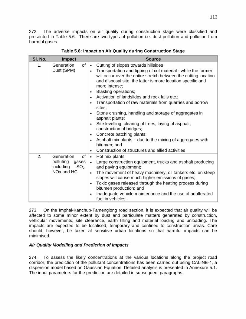
113
272. The adverse impacts on air quality during construction stage were classified and presented in Table 5.6. There are two types of pollution i.e. dust pollution and pollution from harmful gases.
Table 5.6: Impact on Air Quality during Construction Stage
Sl. No. Impact Source 1. Generation of
Dust (SPM) Cutting of slopes towards hillsides Transportation and tipping of cut material - while the former
will occur over the entire stretch between the cutting location and disposal site, the latter is more location specific and more intense;
Blasting operations; Activation of landslides and rock falls etc.; Transportation of raw materials from quarries and borrow
sites; Stone crushing, handling and storage of aggregates in
asphalt plants; Site levelling, clearing of trees, laying of asphalt,
construction of bridges; Concrete batching plants; Asphalt mix plants – due to the mixing of aggregates with
bitumen; and Construction of structures and allied activities
2. Generation of polluting gases including SO2, NOx and HC
Hot mix plants; Large construction equipment, trucks and asphalt producing
and paving equipment; The movement of heavy machinery, oil tankers etc. on steep
slopes will cause much higher emissions of gases; Toxic gases released through the heating process during
bitumen production; and Inadequate vehicle maintenance and the use of adulterated
fuel in vehicles. 273. On the Imphal-Kanchup-Tamenglong road section, it is expected that air quality will be affected to some minor extent by dust and particulate matters generated by construction, vehicular movements, site clearance, earth filling and material loading and unloading. The impacts are expected to be localised, temporary and confined to construction areas. Care should, however, be taken at sensitive urban locations so that harmful impacts can be minimised.
Air Quality Modelling and Prediction of Impacts
274. To assess the likely concentrations at the various locations along the project road corridor, the prediction of the pollutant concentrations has been carried out using CALINE-4, a dispersion model based on Gaussian Equation. Detailed analysis is presented in Annexure 5.1. The input parameters for the prediction are detailed in subsequent paragraphs.
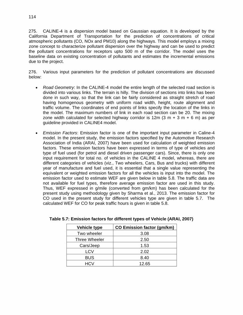
114
275. CALINE-4 is a dispersion model based on Gaussian equation. It is developed by the California Department of Transportation for the prediction of concentrations of critical atmospheric pollutants (CO, NOx and PM10) along the highways. This model employs a mixing zone concept to characterize pollutant dispersion over the highway and can be used to predict the pollutant concentrations for receptors upto 500 m of the corridor. The model uses the baseline data on existing concentration of pollutants and estimates the incremental emissions due to the project. 276. Various input parameters for the prediction of pollutant concentrations are discussed below:
Road Geometry: In the CALINE-4 model the entire length of the selected road section is divided into various links. The terrain is hilly. The division of sections into links has been done in such way, so that the link can be fairly considered as straight stretch of road having homogenous geometry with uniform road width, height, route alignment and traffic volume. The coordinates of end points of links specify the location of the links in the model. The maximum numbers of link in each road section can be 20. The mixing zone width calculated for selected highway corridor is 12m (3 m + 3 m + 6 m) as per guideline provided in CALINE4 model.
Emission Factors: Emission factor is one of the important input parameter in Caline-4
model. In the present study, the emission factors specified by the Automotive Research Association of India (ARAI, 2007) have been used for calculation of weighted emission factors. These emission factors have been expressed in terms of type of vehicles and type of fuel used (for petrol and diesel driven passenger cars). Since, there is only one input requirement for total no. of vehicles in the CALINE 4 model, whereas, there are different categories of vehicles (viz., Two wheelers, Cars, Bus and trucks) with different year of manufacture and fuel used, it is essential that a single value representing the equivalent or weighted emission factors for all the vehicles is input into the model. The emission factor used to estimate WEF are given below in table 5.8. The traffic data are not available for fuel types, therefore average emission factor are used in this study. Thus, WEF expressed in g/mile (converted from gm/km) has been calculated for the present study using methodology given by Sharma et al., 2013. The emission factor for CO used in the present study for different vehicles type are given in table 5.7. The calculated WEF for CO for peak traffic hours is given in table 5.8.
Table 5.7: Emission factors for different types of Vehicle (ARAI, 2007)
Vehicle type CO Emission factor (gm/km) Two wheeler 3.08
Three Wheeler 2.50 Cars/Jeep 1.53
LCV 2.02 BUS 8.40 HCV 12.65
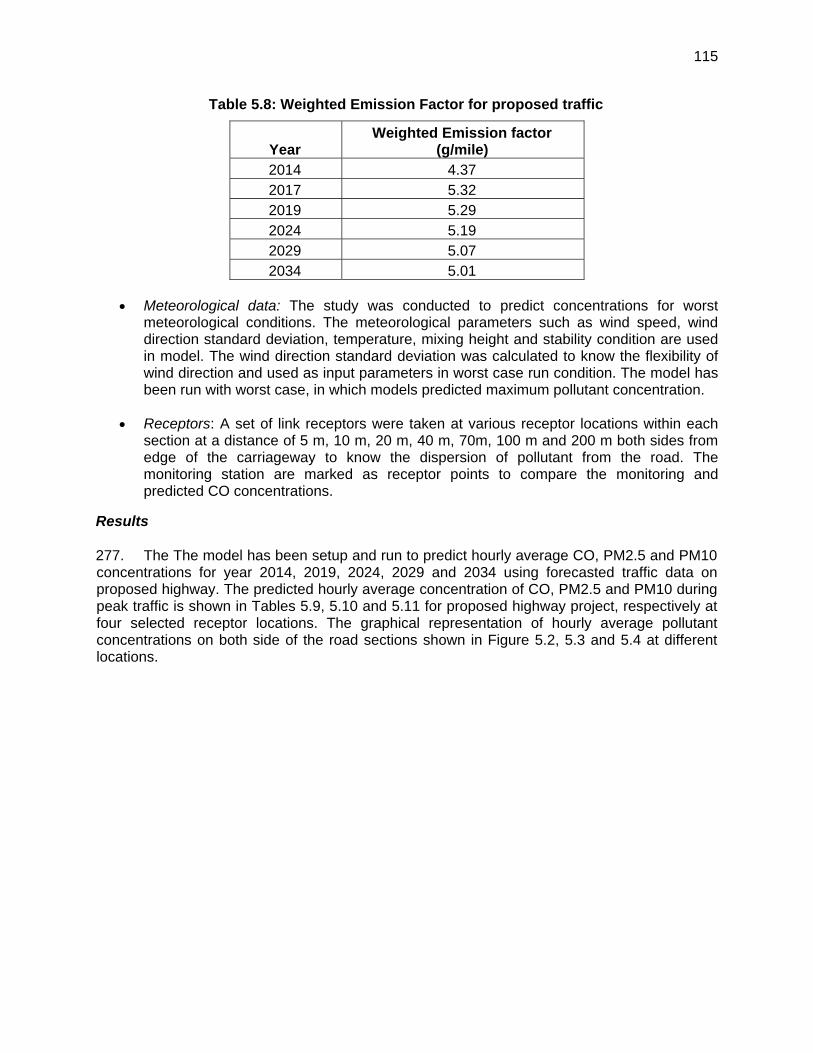
115
Table 5.8: Weighted Emission Factor for proposed traffic
Year Weighted Emission factor
(g/mile) 2014 4.37 2017 5.32 2019 5.29 2024 5.19 2029 5.07 2034 5.01
Meteorological data: The study was conducted to predict concentrations for worst
meteorological conditions. The meteorological parameters such as wind speed, wind direction standard deviation, temperature, mixing height and stability condition are used in model. The wind direction standard deviation was calculated to know the flexibility of wind direction and used as input parameters in worst case run condition. The model has been run with worst case, in which models predicted maximum pollutant concentration.
Receptors: A set of link receptors were taken at various receptor locations within each
section at a distance of 5 m, 10 m, 20 m, 40 m, 70m, 100 m and 200 m both sides from edge of the carriageway to know the dispersion of pollutant from the road. The monitoring station are marked as receptor points to compare the monitoring and predicted CO concentrations.
Results 277. The The model has been setup and run to predict hourly average CO, PM2.5 and PM10 concentrations for year 2014, 2019, 2024, 2029 and 2034 using forecasted traffic data on proposed highway. The predicted hourly average concentration of CO, PM2.5 and PM10 during peak traffic is shown in Tables 5.9, 5.10 and 5.11 for proposed highway project, respectively at four selected receptor locations. The graphical representation of hourly average pollutant concentrations on both side of the road sections shown in Figure 5.2, 5.3 and 5.4 at different locations.
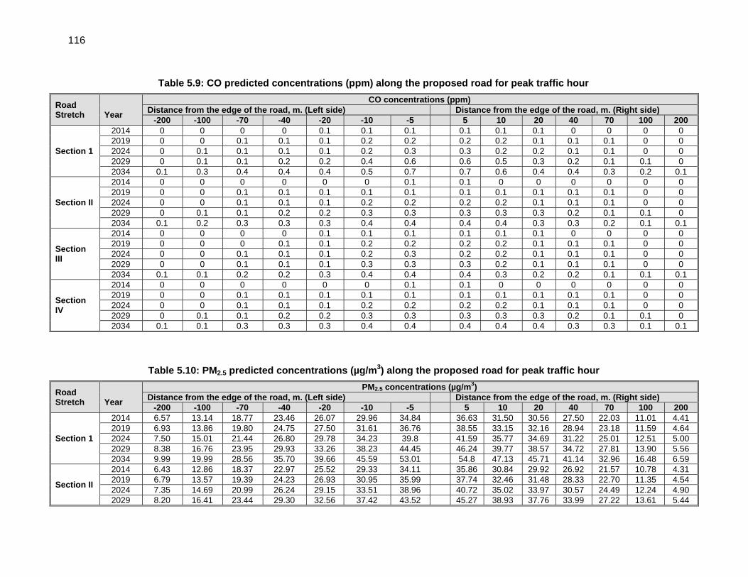
116
Table 5.9: CO predicted concentrations (ppm) along the proposed road for peak traffic hour
Table 5.10: PM2.5 predicted concentrations (µg/m3) along the proposed road for peak traffic hour
Road Stretch
Year
CO concentrations (ppm)Distance from the edge of the road, m. (Left side) Distance from the edge of the road, m. (Right side)
-200 -100 -70 -40 -20 -10 -5 5 10 20 40 70 100 200
Section 1
2014 0 0 0 0 0.1 0.1 0.1 0.1 0.1 0.1 0 0 0 0 2019 0 0 0.1 0.1 0.1 0.2 0.2 0.2 0.2 0.1 0.1 0.1 0 0 2024 0 0.1 0.1 0.1 0.1 0.2 0.3 0.3 0.2 0.2 0.1 0.1 0 0 2029 0 0.1 0.1 0.2 0.2 0.4 0.6 0.6 0.5 0.3 0.2 0.1 0.1 0 2034 0.1 0.3 0.4 0.4 0.4 0.5 0.7 0.7 0.6 0.4 0.4 0.3 0.2 0.1
Section II
2014 0 0 0 0 0 0 0.1 0.1 0 0 0 0 0 0 2019 0 0 0.1 0.1 0.1 0.1 0.1 0.1 0.1 0.1 0.1 0.1 0 0 2024 0 0 0.1 0.1 0.1 0.2 0.2 0.2 0.2 0.1 0.1 0.1 0 0 2029 0 0.1 0.1 0.2 0.2 0.3 0.3 0.3 0.3 0.3 0.2 0.1 0.1 0 2034 0.1 0.2 0.3 0.3 0.3 0.4 0.4 0.4 0.4 0.3 0.3 0.2 0.1 0.1
Section III
2014 0 0 0 0 0.1 0.1 0.1 0.1 0.1 0.1 0 0 0 0 2019 0 0 0 0.1 0.1 0.2 0.2 0.2 0.2 0.1 0.1 0.1 0 0 2024 0 0 0.1 0.1 0.1 0.2 0.3 0.2 0.2 0.1 0.1 0.1 0 0 2029 0 0 0.1 0.1 0.1 0.3 0.3 0.3 0.2 0.1 0.1 0.1 0 0 2034 0.1 0.1 0.2 0.2 0.3 0.4 0.4 0.4 0.3 0.2 0.2 0.1 0.1 0.1
Section IV
2014 0 0 0 0 0 0 0.1 0.1 0 0 0 0 0 0 2019 0 0 0.1 0.1 0.1 0.1 0.1 0.1 0.1 0.1 0.1 0.1 0 0 2024 0 0 0.1 0.1 0.1 0.2 0.2 0.2 0.2 0.1 0.1 0.1 0 0 2029 0 0.1 0.1 0.2 0.2 0.3 0.3 0.3 0.3 0.3 0.2 0.1 0.1 0 2034 0.1 0.1 0.3 0.3 0.3 0.4 0.4 0.4 0.4 0.4 0.3 0.3 0.1 0.1
Road Stretch
Year
PM2.5 concentrations (µg/m3)Distance from the edge of the road, m. (Left side) Distance from the edge of the road, m. (Right side)
-200 -100 -70 -40 -20 -10 -5 5 10 20 40 70 100 200
Section 1
2014 6.57 13.14 18.77 23.46 26.07 29.96 34.84 36.63 31.50 30.56 27.50 22.03 11.01 4.41 2019 6.93 13.86 19.80 24.75 27.50 31.61 36.76 38.55 33.15 32.16 28.94 23.18 11.59 4.64 2024 7.50 15.01 21.44 26.80 29.78 34.23 39.8 41.59 35.77 34.69 31.22 25.01 12.51 5.00 2029 8.38 16.76 23.95 29.93 33.26 38.23 44.45 46.24 39.77 38.57 34.72 27.81 13.90 5.56 2034 9.99 19.99 28.56 35.70 39.66 45.59 53.01 54.8 47.13 45.71 41.14 32.96 16.48 6.59
Section II
2014 6.43 12.86 18.37 22.97 25.52 29.33 34.11 35.86 30.84 29.92 26.92 21.57 10.78 4.31 2019 6.79 13.57 19.39 24.23 26.93 30.95 35.99 37.74 32.46 31.48 28.33 22.70 11.35 4.54 2024 7.35 14.69 20.99 26.24 29.15 33.51 38.96 40.72 35.02 33.97 30.57 24.49 12.24 4.90 2029 8.20 16.41 23.44 29.30 32.56 37.42 43.52 45.27 38.93 37.76 33.99 27.22 13.61 5.44
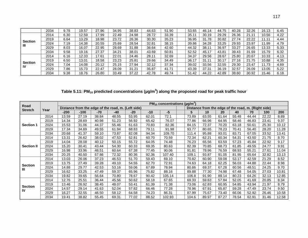
117
Table 5.11: PM10 predicted concentrations (µg/m3) along the proposed road for peak traffic hour
2034 9.78 19.57 27.96 34.95 38.83 44.63 51.90 53.65 46.14 44.75 40.28 32.26 16.13 6.45
Section III
2014 6.30 12.59 17.99 22.49 24.98 28.72 33.39 35.11 30.19 29.29 26.36 21.11 10.56 4.22 2019 6.64 13.29 18.98 23.72 26.36 30.30 35.23 36.95 31.78 30.82 27.74 22.22 11.11 4.44 2024 7.19 14.38 20.55 25.69 28.54 32.81 38.15 39.86 34.28 33.25 29.93 23.97 11.99 4.79 2029 8.03 16.07 22.95 28.69 31.88 36.64 42.60 44.32 38.11 36.97 33.27 26.65 13.33 5.33 2034 9.58 19.16 27.37 34.21 38.01 43.69 50.81 52.52 45.17 43.81 39.43 31.59 15.79 6.32
Section IV
2014 6.16 12.33 17.61 22.01 24.46 28.11 32.69 34.37 29.56 28.67 25.80 20.67 10.33 4.13 2019 6.50 13.01 18.58 23.23 25.81 29.66 34.49 36.17 31.11 30.17 27.16 21.75 10.88 4.35 2024 7.04 14.08 20.12 25.15 27.94 32.12 37.34 39.02 33.56 32.55 29.30 23.47 11.73 4.69 2029 7.86 15.73 22.47 28.09 31.21 35.87 41.71 43.39 37.31 36.19 32.57 26.09 13.05 5.22 2034 9.38 18.76 26.80 33.49 37.22 42.78 49.74 51.42 44.22 42.89 38.60 30.92 15.46 6.18
Road Stretch
Year
PM10 concentrations (µg/m3)Distance from the edge of the road, m. (Left side) Distance from the edge of the road, m. (Right side)
-200 -100 -70 -40 -20 -10 -5 5 10 20 40 70 100 200
Section 1
2014 13.59 27.19 38.84 48.55 53.95 62.01 72.1 73.89 63.55 61.64 55.48 44.44 22.22 8.89 2019 14.34 28.69 40.98 51.23 56.92 65.42 76.07 77.86 66.96 64.95 58.46 46.83 23.41 9.37 2024 15.53 31.06 44.37 55.46 61.63 70.83 82.36 84.15 72.37 70.20 63.18 50.61 25.30 10.12 2029 17.34 34.69 49.55 61.94 68.83 79.11 91.98 93.77 80.65 78.23 70.41 56.40 28.20 11.28 2034 20.68 41.37 59.10 73.87 82.08 94.34 109.70 111.4 95.88 93.01 83.71 67.05 33.52 13.41
Section II
2014 13.31 26.62 38.02 47.53 52.81 60.70 70.59 72.34 62.21 60.34 54.31 43.50 21.75 8.70 2019 14.04 28.08 40.12 50.15 55.72 64.05 74.48 76.23 65.56 63.59 57.23 45.84 22.92 9.17 2024 15.20 30.41 43.44 54.30 60.33 69.35 80.63 82.39 70.85 68.73 61.85 49.55 24.77 9.91 2029 16.98 33.96 48.51 60.64 67.38 77.45 90.06 91.81 78.96 76.59 68.93 55.21 27.61 11.04 2034 20.25 40.50 57.86 72.32 80.36 92.36 107.40 109.1 93.87 91.05 81.95 65.64 32.82 13.13
Section III
2014 13.03 26.06 37.23 46.53 51.70 59.43 69.10 70.82 60.90 59.08 53.17 42.59 21.29 8.52 2019 13.75 27.49 39.28 49.10 54.55 62.70 72.91 74.63 64.18 62.25 56.03 44.88 22.44 8.98 2024 14.88 29.77 42.53 53.16 59.06 67.89 78.94 80.66 69.37 67.28 60.56 48.51 24.25 9.70 2029 16.62 33.25 47.49 59.37 65.96 75.82 88.16 89.88 77.30 74.98 67.48 54.05 27.03 10.81 2034 19.82 39.65 56.64 70.80 78.67 90.42 105.14 106.8 91.90 89.14 80.23 64.26 32.13 12.85
Section IV
2014 12.76 25.51 36.44 45.56 50.62 58.18 67.65 69.33 59.63 57.84 52.05 41.69 20.85 8.34 2019 13.46 26.92 38.45 48.07 53.41 61.39 71.38 73.06 62.83 60.95 54.85 43.94 21.97 8.79 2024 14.57 29.14 41.63 52.04 57.82 66.46 77.28 78.96 67.91 65.87 59.28 47.49 23.74 9.50 2029 16.27 32.55 46.50 58.12 64.58 74.23 86.31 87.99 75.67 73.40 66.06 52.92 26.46 10.58 2034 19.41 38.82 55.45 69.31 77.02 88.52 102.93 104.6 89.97 87.27 78.54 62.91 31.46 12.58
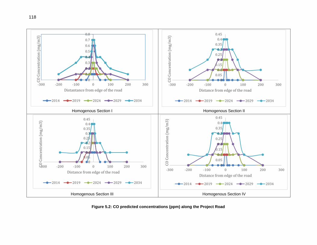
118
Homogenous Section I Homogenous Section II
Homogenous Section III Homogenous Section IV
Figure 5.2: CO predicted concentrations (ppm) along the Project Road
0
0.1
0.2
0.3
0.4
0.5
0.6
0.7
0.8
‐300 ‐200 ‐100 0 100 200 300
COConcentration(mg/m3)
Distantancefromedgeoftheroad
2014 2019 2024 2029 2034
00.050.10.150.20.250.30.350.40.45
‐300 ‐200 ‐100 0 100 200 300
COConcentration(mg/m3)
Distancefromedgeoftheroad
2014 2019 2024 2029 2034
00.050.10.150.20.250.30.350.40.45
‐300 ‐200 ‐100 0 100 200 300COConcentration(mg/m3)
Distancefromedgeoftheroad
2014 2019 2024 2029 2034
0
0.05
0.1
0.15
0.2
0.25
0.3
0.35
0.4
0.45
‐300 ‐200 ‐100 0 100 200 300COConcentration(mg/m3)
Distancefromedgeoftheroad
2014 2019 2024 2029 2034
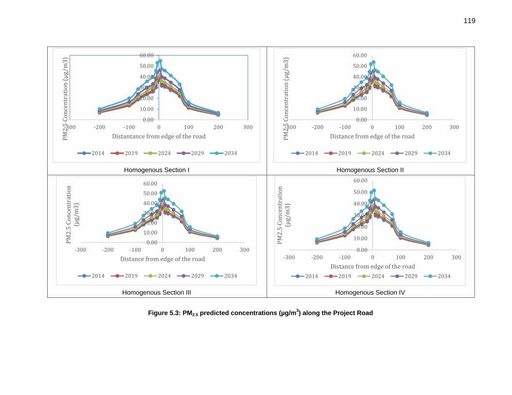
119
Homogenous Section I Homogenous Section II
Homogenous Section III Homogenous Section IV
Figure 5.3: PM2.5 predicted concentrations (µg/m3) along the Project Road
0.00
10.00
20.00
30.00
40.00
50.00
60.00
‐300 ‐200 ‐100 0 100 200 300
PM2.5Concentration(µg/m3)
Distantancefromedgeoftheroad
2014 2019 2024 2029 2034
0.00
10.00
20.00
30.00
40.00
50.00
60.00
‐300 ‐200 ‐100 0 100 200 300
PM2.5Concentration(µg/m3)
Distancefromedgeoftheroad
2014 2019 2024 2029 2034
0.00
10.00
20.00
30.00
40.00
50.00
60.00
‐300 ‐200 ‐100 0 100 200 300
PM2.5Concentration
(µg/m3)
Distancefromedgeoftheroad
2014 2019 2024 2029 2034
0.00
10.00
20.00
30.00
40.00
50.00
60.00
‐300 ‐200 ‐100 0 100 200 300
PM2.5Concentration
(µg/m3)
Distancefromedgeoftheroad
2014 2019 2024 2029 2034
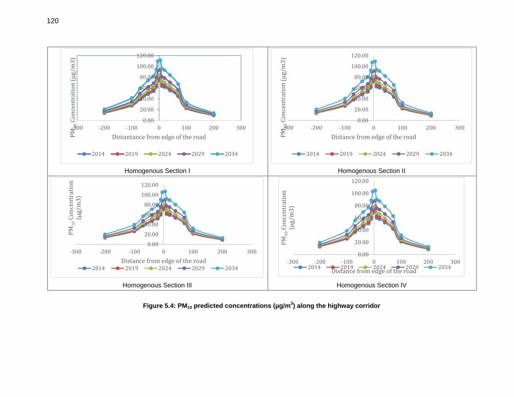
120
Homogenous Section I Homogenous Section II
Homogenous Section III Homogenous Section IV
Figure 5.4: PM10 predicted concentrations (µg/m3) along the highway corridor
0.00
20.00
40.00
60.00
80.00
100.00
120.00
‐300 ‐200 ‐100 0 100 200 300
PM10Concentration(µg/m3)
Distantancefromedgeoftheroad
2014 2019 2024 2029 2034
0.00
20.00
40.00
60.00
80.00
100.00
120.00
‐300 ‐200 ‐100 0 100 200 300
PM10Concentration(µg/m3)
Distancefromedgeoftheroad
2014 2019 2024 2029 2034
0.00
20.00
40.00
60.00
80.00
100.00
120.00
‐300 ‐200 ‐100 0 100 200 300
PM10Concentration
(µg/m3)
Distancefromedgeoftheroad2014 2019 2024 2029 2034
0.00
20.00
40.00
60.00
80.00
100.00
120.00
‐300 ‐200 ‐100 0 100 200 300
PM10Concentration
(µg/m3)
Distancefromedgeoftheroad2014 2019 2024 2029 2034
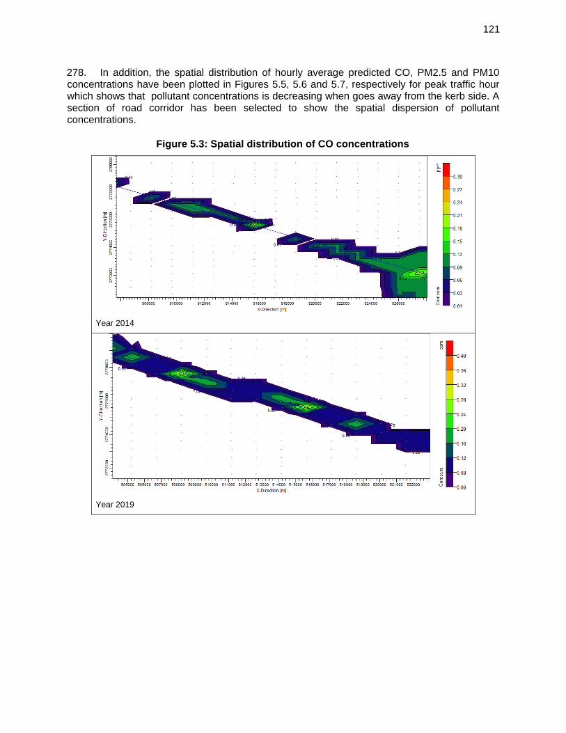
121
278. In addition, the spatial distribution of hourly average predicted CO, PM2.5 and PM10 concentrations have been plotted in Figures 5.5, 5.6 and 5.7, respectively for peak traffic hour which shows that pollutant concentrations is decreasing when goes away from the kerb side. A section of road corridor has been selected to show the spatial dispersion of pollutant concentrations.
Figure 5.3: Spatial distribution of CO concentrations
Year 2014
Year 2019
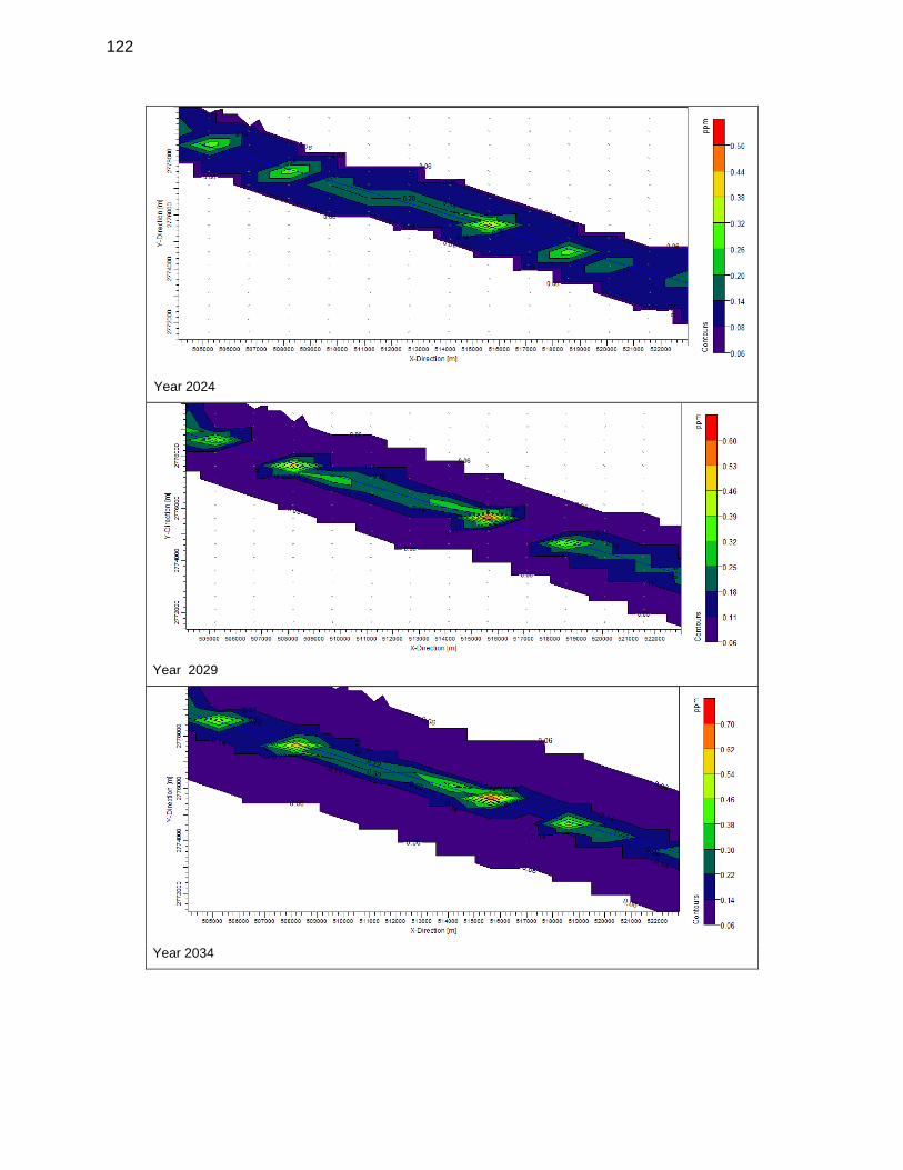
122
Year 2024
Year 2029
Year 2034
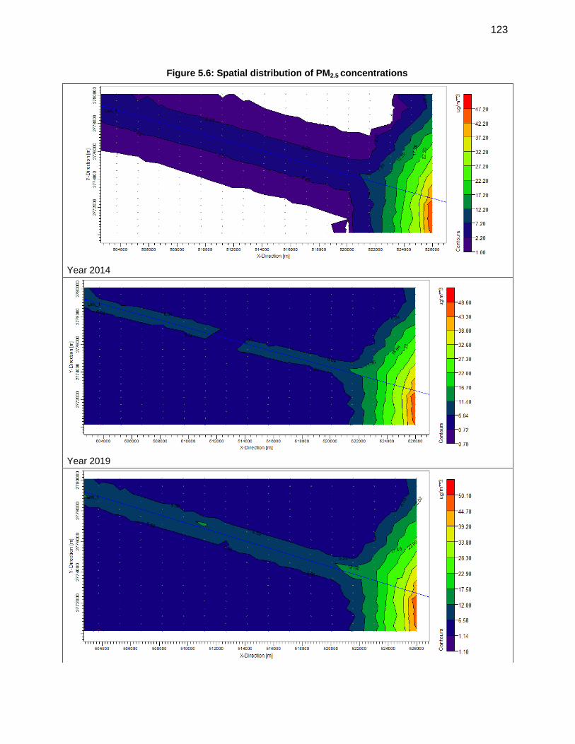
123
Figure 5.6: Spatial distribution of PM2.5 concentrations
Year 2014
Year 2019
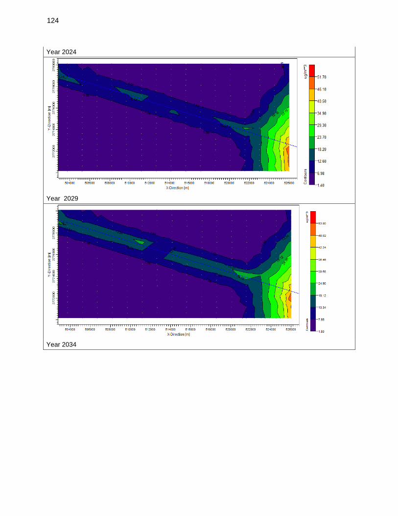
124
Year 2024
Year 2029
Year 2034
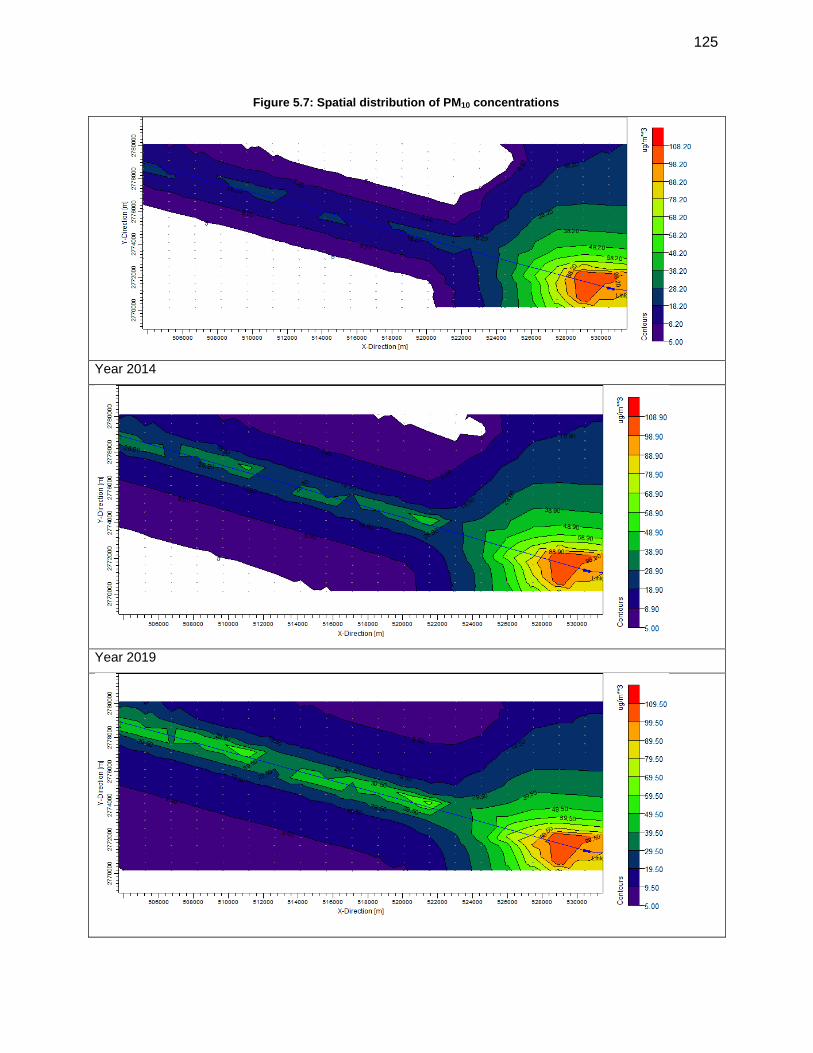
125
Figure 5.7: Spatial distribution of PM10 concentrations
Year 2014
Year 2019
126
Year2024
279. It has been observed from the model output that when the traffic volume increases, the concentration of air pollutants also increases correspondingly. However, the maximum predicted pollutant concentrations of CO, PM2.5 and PM10 over the existing ambient air quality are found to be within the National Ambient Air Quality Standards as well as IFC (World Bank EHS Guidelines).
f. Noise Levels
280. With the exception of the urban centres such as Imphal and Tamenglong, the ambient noise level along the road sections is within standards. During the construction period, noise will be generated from the operation of heavy machinery, blasting works, the haulage of construction materials to the construction yard and the general activities at the yard itself. Concrete mixing and material movements will be the primary noise generating activities and will be uniformly distributed over the entire construction period. These construction activities are expected to produce noise levels in the range of 80-95 dB(A) at a distance of about 5 m from the source. 281. Construction noise is not normally regulated, though still may cause concern among local villagers. The range of typical noise levels in relation to distance from a construction site is shown in Table 5.11.
Table 5.12: Construction Noise / Distance Relationship
Distance from construction site (m) Range of Typical Noise Level dB(A)
8 82 – 102
15 75 – 95
30 69 – 89
61 63 – 83
127
Distance from construction site (m) Range of Typical Noise Level dB(A)
91 59 – 79
122 57 – 77
152 55 – 75
305 49 - 69
Source: Department of Transportation, State of Wisconsin (USA)
282. Piling, if necessary, will also cause vibration. Noise and vibration from this source will be unavoidable but the impact will only be temporary and affect people living or working near piling locations. In construction sites within 500 metres of a settlement, noisy operations should cease between 22:00 and 06:00 hrs. Regular maintenance of construction vehicles and machinery must also be undertaken to reduce noise. The impact and sources of noise and vibration are summarised in Table 5.12.
Table 5.13: Likely Impact on Noise Quality in the Vicinity of Project Area
Impact Source
Increased noise levels causing discomfort to local residents, workers and local fauna
Mobilisation of heavy construction machinery;
Accelerations/ decelerations/ gear changes – though the extent of impact will depend on the level of congestion and smoothness of the road surface;
Use of blasting to cut into hill sides;
Excavation work for foundations and grading;
Construction of structures and other facilities;
Crushing plants, asphalt production plants; and loading, transportation and unloading of construction materials.
283. Typical noise levels associated with various construction activities and equipment are presented in Table 5.13.
Table 5.14: Typical noise levels of principal construction equipments (Noise Level in db (A) at 50 Feet)
Clearing Structure Construction
Bulldozer 80 Crane 75-77
Front end loader 72-84 Welding generator 71-82
Jack hammer 81-98 Concrete mixer 74-88
Crane with ball 75-87 Concrete pump 81-84
Concrete vibrator 76
Excavation and Earth Moving Air compressor 74-87
128
Clearing Structure Construction
Bulldozer 80 Pneumatic tools 81-98
Backhoe 72-93 Bulldozer 80
Front end loader 72-84 Cement and dump trucks 83-94
Dump truck 83-94 Front end loader 72-84
Jack hammer 81-98 Dump truck 83-94
Scraper 80-93 Paver 86-88
Grading and Compaction Landscaping and clean-up
Grader 80-93 Bulldozer 80
Roller 73-75 Backhoe 72-93
Truck 83-94
Paving Front and end loader 72-84
Paver 86-88 Dump truck 83-94
Truck 83-94 Paver 86-88
Tamper 74-77 Dump truck 83-94
Source: U.S. Environmental Protection Agency, noise from Construction Equipment and Operations. Building Equipment and Home Appliance. NJID. 300.1.December 31, 1971
284. The noise levels indicated for various construction activities/equipment, while far exceeding permissible standards of CPCB and WB EHS for residential areas, it will occur only intermittently. Still, these extremely high sound levels present real risk to the health of workers on- site. Timely scheduling of construction activities, proper maintenance of construction machineries, use of personnel protective equipments etc. will minimize these impacts. 285. Residences, schools, health clinics, and other noise sensitive areas within 100 m the roadways will be affected temporarily during construction. The number of persons potentially affected and the duration of these effects cannot be estimated based on available information. 286. During construction, varying degree of noise impacts are likely to be felt by the communities of main settlements i.e. Imphal, Kanchup, and Tamenglong and other small settlements along the project road. Although temporary in nature, the construction noise will affect the most communities living close to the construction zone. 287. Noise impacts are an unavoidable consequence of construction that should be mitigated by limiting the times of construction to daylight hours (8am-5pm) in the vicinity of sensitive receptors. Further to minimize noise impacts near sensitive receptors (particularly schools), operation of excavator and other heavy machineries will be carried out mostly during off-hours (7 am to 9 am) and 3.30 pm to 7 pm) and on holidays (Saturday and Sundays). Baseline noise will be established for all sensitive areas prior to construction and follow up noise monitoring will be carried out during the construction.
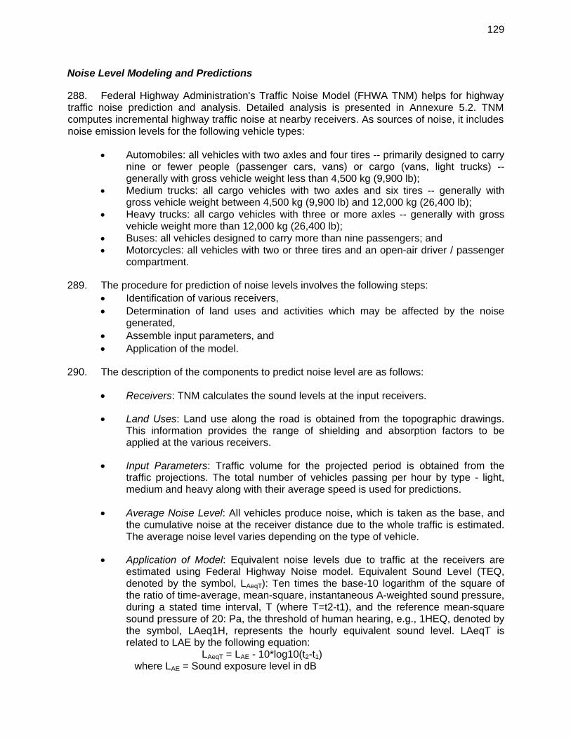
129
Noise Level Modeling and Predictions 288. Federal Highway Administration's Traffic Noise Model (FHWA TNM) helps for highway traffic noise prediction and analysis. Detailed analysis is presented in Annexure 5.2. TNM computes incremental highway traffic noise at nearby receivers. As sources of noise, it includes noise emission levels for the following vehicle types:
Automobiles: all vehicles with two axles and four tires -- primarily designed to carry nine or fewer people (passenger cars, vans) or cargo (vans, light trucks) -- generally with gross vehicle weight less than 4,500 kg (9,900 lb);
Medium trucks: all cargo vehicles with two axles and six tires -- generally with gross vehicle weight between 4,500 kg (9,900 lb) and 12,000 kg (26,400 lb);
Heavy trucks: all cargo vehicles with three or more axles -- generally with gross vehicle weight more than 12,000 kg (26,400 lb);
Buses: all vehicles designed to carry more than nine passengers; and Motorcycles: all vehicles with two or three tires and an open-air driver / passenger
compartment. 289. The procedure for prediction of noise levels involves the following steps:
Identification of various receivers, Determination of land uses and activities which may be affected by the noise
generated, Assemble input parameters, and Application of the model.
290. The description of the components to predict noise level are as follows:
Receivers: TNM calculates the sound levels at the input receivers. Land Uses: Land use along the road is obtained from the topographic drawings.
This information provides the range of shielding and absorption factors to be applied at the various receivers.
Input Parameters: Traffic volume for the projected period is obtained from the
traffic projections. The total number of vehicles passing per hour by type - light, medium and heavy along with their average speed is used for predictions.
Average Noise Level: All vehicles produce noise, which is taken as the base, and
the cumulative noise at the receiver distance due to the whole traffic is estimated. The average noise level varies depending on the type of vehicle.
Application of Model: Equivalent noise levels due to traffic at the receivers are
estimated using Federal Highway Noise model. Equivalent Sound Level (TEQ, denoted by the symbol, LAeqT): Ten times the base-10 logarithm of the square of the ratio of time-average, mean-square, instantaneous A-weighted sound pressure, during a stated time interval, T (where T=t2-t1), and the reference mean-square sound pressure of 20: Pa, the threshold of human hearing, e.g., 1HEQ, denoted by the symbol, LAeq1H, represents the hourly equivalent sound level. LAeqT is related to LAE by the following equation:
LAeqT = LAE - 10*log10(t2-t1) where LAE = Sound exposure level in dB
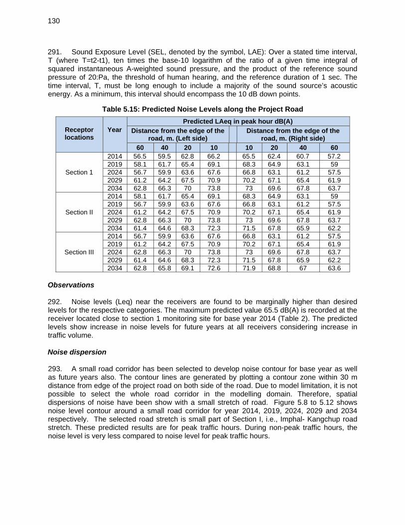
130
291. Sound Exposure Level (SEL, denoted by the symbol, LAE): Over a stated time interval, T (where T=t2-t1), ten times the base-10 logarithm of the ratio of a given time integral of squared instantaneous A-weighted sound pressure, and the product of the reference sound pressure of 20:Pa, the threshold of human hearing, and the reference duration of 1 sec. The time interval, T, must be long enough to include a majority of the sound source’s acoustic energy. As a minimum, this interval should encompass the 10 dB down points.
Table 5.15: Predicted Noise Levels along the Project Road
Observations 292. Noise levels (Leq) near the receivers are found to be marginally higher than desired levels for the respective categories. The maximum predicted value 65.5 dB(A) is recorded at the receiver located close to section 1 monitoring site for base year 2014 (Table 2). The predicted levels show increase in noise levels for future years at all receivers considering increase in traffic volume. Noise dispersion 293. A small road corridor has been selected to develop noise contour for base year as well as future years also. The contour lines are generated by plotting a contour zone within 30 m distance from edge of the project road on both side of the road. Due to model limitation, it is not possible to select the whole road corridor in the modelling domain. Therefore, spatial dispersions of noise have been show with a small stretch of road. Figure 5.8 to 5.12 shows noise level contour around a small road corridor for year 2014, 2019, 2024, 2029 and 2034 respectively. The selected road stretch is small part of Section I, i.e., Imphal- Kangchup road stretch. These predicted results are for peak traffic hours. During non-peak traffic hours, the noise level is very less compared to noise level for peak traffic hours.
Receptor locations
Year
Predicted LAeq in peak hour dB(A)
Distance from the edge of the road, m. (Left side)
Distance from the edge of the road, m. (Right side)
60 40 20 10 10 20 40 60
Section 1
2014 56.5 59.5 62.8 66.2 65.5 62.4 60.7 57.2 2019 58.1 61.7 65.4 69.1 68.3 64.9 63.1 59 2024 56.7 59.9 63.6 67.6 66.8 63.1 61.2 57.5 2029 61.2 64.2 67.5 70.9 70.2 67.1 65.4 61.9 2034 62.8 66.3 70 73.8 73 69.6 67.8 63.7
Section II
2014 58.1 61.7 65.4 69.1 68.3 64.9 63.1 59 2019 56.7 59.9 63.6 67.6 66.8 63.1 61.2 57.5 2024 61.2 64.2 67.5 70.9 70.2 67.1 65.4 61.9 2029 62.8 66.3 70 73.8 73 69.6 67.8 63.7 2034 61.4 64.6 68.3 72.3 71.5 67.8 65.9 62.2
Section III
2014 56.7 59.9 63.6 67.6 66.8 63.1 61.2 57.5 2019 61.2 64.2 67.5 70.9 70.2 67.1 65.4 61.9 2024 62.8 66.3 70 73.8 73 69.6 67.8 63.7 2029 61.4 64.6 68.3 72.3 71.5 67.8 65.9 62.2 2034 62.8 65.8 69.1 72.6 71.9 68.8 67 63.6
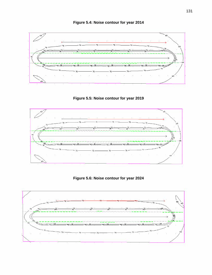
131
Figure 5.4: Noise contour for year 2014
Figure 5.5: Noise contour for year 2019
Figure 5.6: Noise contour for year 2024
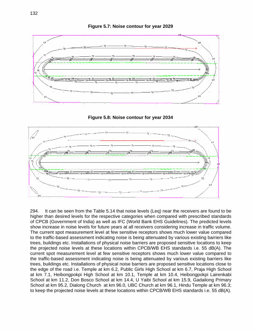
132
Figure 5.7: Noise contour for year 2029
Figure 5.8: Noise contour for year 2034
294. It can be seen from the Table 5.14 that noise levels (Leq) near the receivers are found to be higher than desired levels for the respective categories when compared with prescribed standards of CPCB (Government of India) as well as IFC (World Bank EHS Guidelines). The predicted levels show increase in noise levels for future years at all receivers considering increase in traffic volume. The current spot measurement level at few sensitive receptors shows much lower value compared to the traffic-based assessment indicating noise is being attenuated by various existing barriers like trees, buildings etc. Installations of physical noise barriers are proposed sensitive locations to keep the projected noise levels at these locations within CPCB/WB EHS standards i.e. 55 dB(A). The current spot measurement level at few sensitive receptors shows much lower value compared to the traffic-based assessment indicating noise is being attenuated by various existing barriers like trees, buildings etc. Installations of physical noise barriers are proposed sensitive locations close to the edge of the road i.e. Temple at km 6.2, Public Girls High School at km 6.7, Praja High School at km 7.1, Heibongpokpi High School at km 10.1, Temple at km 10.4, Heibongpokpi Lairenkabi School at km 11.2, Don Bosco School at km 14.4, U Yaibi School at km 15.9, Gadailong Primary School at km 95.2, Dialong Church at km 96.0, UBC Church at km 96.1, Hindu Temple at km 96.3; to keep the projected noise levels at these locations within CPCB/WB EHS standards i.e. 55 dB(A).
133
295. Although estimated noise over the project duration shows higher noise levels at various receptor locations; implementation of suitable mitigation measures will reduce the construction noise to acceptable limits. Mitigation measures should include:
Installations of noise barriers; construction machinery should be located away from settlements; careful planning of machinery operation and the scheduling of such operations; controlled blasting should only be carried out with prior approval from the Engineer in
charge; contractors should be required to fit noise shields on construction machinery and to
provide earplugs to the operators of heavy machines; blasting should be conducted only during day-light hours; and only controlled blasting should be conducted.
296. Trees will be planted along the road to act as natural barrier to noise. Further, physical noise barriers have been provided in the subproject design. These physical noise barriers can be constructed from earth, concrete, masonry, wood, metal, and other materials. To effectively reduce sound transmission through the barrier, the material chosen must be rigid and sufficiently dense (at least 20 kilograms/square meter). To effectively reduce the noise coming around its ends, a barrier should be at least eight times as long as the distance from the home or receiver to the barrier.
g. Topography and Appearance
297. Construction activities of the project road will bring permanent changes in the local-level topography and appearance of the project site. There will be loss in aesthetic beauty of the project area mainly due to the earthwork. Table 5.15 elaborates potential effects on the topography and appearance and appropriate mitigation measures.
Table 5.16: Potential Effects on Topography by the Proposed Road Section Upgrading
SI. No.
Construction activity
Potential effect on topography and appearance
Mitigation
1. Clearing of vegetation and cutting of hillside for widening of the road
Scarring of landscape from cutting and potential landslides (short term and long term) may be caused. There may be minor permanent changes in the landscape.
Cut material should be used to widen the road or disposed off at proper disposal sites. Cut slopes should be re-vegetated immediately after widening activities.
2. Stone quarrying Scarring of landscape and potential landslides (rock slides/falls). There may be permanent changes in the landscape.
Stone quarrying should only be undertaken in legally approved areas. Controlled and environmental friendly quarrying should be carried out to minimise landslides and erosion.
3. Earthwork from borrow areas
Scarring of landscape due to unearthing activities. Minor but permanent changes in landscape.
Borrow areas should be in legally approved locations. As soon as construction activities are complete, they should be re-vegetated and brought back
134
SI. No.
Construction activity
Potential effect on topography and appearance
Mitigation
as far as possible to their previous appearance.
4 Waste disposal Disposal of cut soils and debris at improper locations such as hillside below the road will make the area look untidy and unattractive.
Cut off material should be used to widen the road or disposed of at proper disposal sites.
5 Establishment of labour camps
Disposal of waste and litter at improper locations and deforestation for fire-wood will make the area look dirty and unattractive.
Provision and allocation of proper waste disposal bins and sites are required. A supply of cooking gas should be provided by the contractor to eliminate the use of fire wood.
3. Ecological Resources
a. Wildlife
298. The proposed road alignment is not located inside or within a 10 kilometer distance from a legally protected or key biodiversity area which was identified as the corridor of impact. 299. The impacts of road building to wildlife includes direct and indirect mortality; destroying, degrading, and fragmenting habitat; serves as barriers to movement; and spurs domino effect brought by a change in land-use. Small animals that often disperse, large animals like ungulates and carnivores are at risk to road kills during project operation. The construction of the new road section, with a total length of 96.35 kilometers across forested areas may cause wildlife habitat fragmentation, and disruption of wildlife movement corridors. 300. To avoid impacts to wildlife the following measures will be implemented:
Use of exclusion zones through fencing to channel medium and large vertebrates (e.g. Hog Deer and Eld’s Deer) crossings along specific sections or along landscape connectors like animal overpasses
Bridge design including approaches will take into account wildlife movements along riparian corridors
Where smaller animals like Manipur rat are known to disperse, road design will consider the construction of faunal culvert or pipe crossing
Where endangered and critically endangered bird species are known take territories along the road, strict noise control will be implemented particularly during construction period to avoid disturbance
Information and cautionary roadside signages will be installed to warn drivers of impending sensitive areas
b. Vegetation
301. Part of the subproject road passes though the forest area. The density of vegetation in forest is 0.4 to 0.5. Removal of the existing vegetative cover and the uprooting of 2732 trees is an unfortunate activity, which will reduce the ecological balance in the areas. This will also enhance soil erosion. About 2910,000 sq m (30 m strip for entire length 97 km) of scrub forests and
135
vegetation will probably be removed for improvement of road section between Kanchup and Tamenglong. The loss of vegetative cover will mostly be permanent and only some might be revived through mitigation efforts. Another impact from road construction activities and deriving from the cutting of hillsides, quarrying, preparation and transfer of stone chips and other earthwork; is the accumulation of dust on the surrounding vegetation. This leads to deterioration of the vegetative health, which in turn will affect the ecology as well as the aesthetic beauty of the area. Induced impacts may result from the following:
increased forest harvesting for fire-wood, construction timber, forage, medicinal plants and other products;
increased earth and rock extraction; construction crew demands for wood as a fuel and for building materials; construction crew demands for food and recreational hunting and fishing;
302. To minimise negative impacts on the vegetative cover the contract documents should specify that:
all wood building material for workers’ housing should be brought from outside the project area;
workers should be supplied with non-wood fuels such as kerosene or liquefied petroleum gas for the duration of the contract;
all contract equipment and plants should be cleaned to the satisfaction of the project engineer in charge prior to their relocation to project sites;
during site clearance, care should be taken to ensure that the minimum area of vegetation area is affected; and
water sprinkling of trucks used as construction vehicles should be properly and regularly undertaken, so that dust deposition problem on vegetation are minimised.
4. Human Use Values
303. Field reconnaissance surveys of the project road were conducted to assess the environmental and social conditions. It was noted that the relocation of structures will be required at congested locations along the subproject road mainly Imphal, Kanchup and Tamenglong. The widening options have been devised to minimise impacts of structures. 304. The survey also found that there are 345 temporary structure and three shrines likely to be affected due to widening of road section. A resettlement plan is prepared to address this issue. The affected people will be compensated and rehabilitated as per the provisions of the Resettlement Plan. 305. There will be negligible land acquisition as the proposed widening will be accommodated within existing ROW i.e. 54 ft either side of the road. 306. At certain locations on the road, particularly at bridge /culver sites, traffic will be temporarily diverted from the existing carriageway while construction is in progress and temporary traffic diversions will be managed within the ROW. In other instances, traffic may have to be diverted across adjacent private land, in which case compensation will be paid for any loss of crops or the replacement of damaged structures. In other situations, most frequently not at bridge sites, for example when bitumen surfacing is in progress, it may be required to close the road temporarily. In these circumstances, adequate radio and press releases should be made beforehand and a date/time given for the re-opening.
136
307. Most construction will be undertaken during the dry season when few crops are planted. Losses should be minimised during construction.
5. Sensitive Location Such as School, College and Hospital along the Project Road
308. The sensitive location such as school, college and hospital along subproject road within 100 meter from the edge of the existing road has been identified as given Table 5.14.
Table 5.17: Sensitive Locations along the Project Road
Location / Chainage (Km) Features
6.2 Temple
6.7 The Public Girls High School
7.1 Praja High School
10.1 Heibongpokpi High School
10.4 Temple
11.2 Heibongpokpi Lairenkabi School
14.4 Don Bosco School Phayeng
15.9 U Yaibi School
52.0 Bakua village through middle
84.5 Phalong field, Community Hall
95.2 Gadailong Primary School
96.0 Dialong Church
96.1 UBC Church
96.3 Hindu Temple
309. These structures are kept unaffected by the proposed improvement proposal. Short term impacts during the construction stage are expected. Measures such as timely scheduling of construction activities in these areas, provision of sign boards, appropriate noise barriers such as planting trees and / or raised boundary walls are adopted to minimize impacts.
6. Health, Safety and Hygiene for Construction Workers
310. Construction of the road will result in the generation of waste. In isolated places, the amount of waste generated may be greater than normal because of substandard subsoil materials, which will need to the replaced. 311. The Contractor will be required to control the construction site, keep it clean and provide facilities such as dust bins and collectors for the temporary storage of all waste. This waste should be adequately stored to avoid pollution of water supplies and water sources and to avoid dust formation. The Contractor will be responsible for the safe removal and/or storage of all waste in order to prevent environmental pollution of any type that may be harmful to people or animals. 312. All necessary safeguards should be taken to ensure the safety, welfare and good health of all persons entitled to be on the sites and to ensure that works are carried out in a safe and efficient manner. All personnel working at vulnerable site locations will wear safety helmets and
137
strong footwear. It should be ensured that all workmen and staff employed on site use proper safety equipment – for example, eye protectors, ear plugs, safety helmets, the designated safety equipment when working over water - and that proper rescue equipment is available. Fire extinguishers and first-aid equipment will be kept at all sites. 313. The construction camps are anticipated to house up to 200 people for about two years. With this concentration of people, the potential for the transmission of diseases and illnesses will increase. The main health and safety risks during construction will arise from:
inadequate sanitation facilities in worker camps; introduction of sexually transmitted, and other diseases, by immigrant workers; and outbreaks of malaria, typhoid, cholera etc. amongst the labour force.
314. The following actions will be undertaken at construction camps and stipulated in construction contracts:
submit and obtain approval for a health and safety plan prior to the commencement of work;
provision of adequate health care facilities; and workers will be required to undergo pre-employment medical screening and
treatment (if required) and periodic health checks thereafter. 315. The project will support a public health education programme for workers and villagers covering road safety, malaria, hygiene, and sexually transmitted diseases. The district health departments will also be invited to participate in monitoring and educating communities and workers affected by the project.
7. Nuisance to Nearby Properties
316. Nuisance to nearby properties is likely to result from: noise and vibration from mechanical devices and construction plant; dust during quarrying, construction and the trafficking of new surfaces prior to
sealing; gaseous emissions from heavy equipment; and fumes from asphalt boiling sites.
317. Much of the project road length in Kunchup-Tamenglong section passes through hilly terrain and presently air/dust pollution is not a major issue. Nonetheless, there will be regular watering of the road surfaces or the application of emulsion coats near villages, where dust is a nuisance. Noise generating equipment such as power generators and concrete mixers will be kept away from populated/commercial areas. Provisions will be incorporated into the contractor’s contract to require the use of dust suppression measures.
8. Interference with Utilities and Traffic
318. On the project road, utilities interfere with the ROW at few locations that will have to be shifted / removed prior to construction. This should not be a major problem. 319. Traffic may experience minor delays when diverted around active construction areas, but will be more severely hampered at the locations where temporary road closures are necessary. Such hazard points will have proper signs indicating the nature of the problem envisaged.

138
320. Contractor will ensure that information on the timing of construction works and notifications of road closure (if any) is provided via the local media (radio, TV, newspaper etc.) or through the local community heads.
9. Community Impacts
321. Community impacts are mostly due to the resettlement of people due to widening of the project road to 4/2 lanes. 322. Construction camps may put stress on local resources and the infrastructure in nearby communities resulting to people raising grievances. This sometimes leads to aggression between residents and migrant workers. To prevent such problems, the contractor should provide the construction camps with facilities such as health care clinics, places of worship, and occasional entertainment. The use of local labourers during the construction will be promoted to minimise these problems.
10. Quality of Life
323. The impact of the improvements of project road on the socio-economic environment will be significantly beneficial. Improved access and reduced travel time and cost will be major stimuli to economic growth, particularly in rural areas. Better access of agricultural goods to market will be important and a major contributor to poverty reduction. 324. Increased labour mobility will occur. This has both positive and negative impacts. Increased access is a two-way phenomenon, and the corollary to increased access to the project areas is increased access for the residents of these areas to more urban life-styles. Out-migration may result. There is also the likelihood of the relocation of homes and businesses to new road-side locations. 325. During construction, benefits to local people can be maximised if the contractor recruits construction workers locally regardless of gender. Where possible, he/she should also not discriminate in the employment of women.
11. Construction Materials
326. The use of proper sources for stone and aggregates has become a major issue in most of the north-eastern states. Historically, stone has been collected from the roadside or from shallow surface workings. Small quarries on steep slopes are often enlarged by blasting or excavation at the base. This is dangerous and can cause slope failures. Roadside stone collection continues in some districts despite its proven negative impacts on road safety and stability. Sand and gravel are often obtained from river deposits. Jurisdiction over stone and aggregates is shared between the Geological Survey of India and the State Forest Department. The Geological Survey of India issues licences for major mineral developments while the Forest Department issues permits for stone quarrying and for sand and gravel extraction. This is largely because these are mostly found on forest lands. Roadside quarrying is officially discouraged, but unofficially continues, invariably by petty contractors. 327. Adequate earth material is available from barren land in the vicinity. Estimated quantity is 1,45,500 cum Aggregates (320000 MT) will be mostly sourced from licensed quarries available locally. Sand 80,000 cum will be taken from river beds after prior permission from competent authority.

139
328. Construction water requirement (avg. 300KLD and peak 400 KLD) will be met through local rivers and other local streams. Domestic water requirement (50 KLD) for workers will also be met mainly through local streams. If needed, groundwater may also be abstracted. 329. Road maintenance, repair and new construction will continue to cause large demands for construction materials. There is a clear need for a better materials supply policy in each district to minimise environmental impacts of small-scale, poorly managed operations and improve the quality and reliability of supply. In some districts, it may be appropriate to develop centralised quarries, if an operator can be attracted. In any case, pre-designation of sources would give contractors a level playing field for bidding and minimise incentives for environmentally damaging cost cutting. 330. The engineering team as part of material survey has identified and recommended sources of the construction materials. Details are these sources are provided in Volume 1 (Material survey chapter) of Detailed Project Report. As a prior requirement of project, every new quarry and borrow area should also be subjected to a site specific environmental investigation work according to an approved plan; and should be left in a safe condition or restored to a productive land use. Subject to these conditions, obtaining construction materials for projects will not cause unacceptable impacts. 331. Quarry and borrow pits may be filled with rejected construction waste and afterwards should be given a vegetative cover. If this is not possible, then the excavated slopes will be filled in such a way that they resemble an original ground surface. 332. Mitigation for Quarries
aggregates will be first sourced from licensed quarry sites (which are in operation) that comply with environmental and other applicable regulations;
occupational safety procedures/practices for the work force will be adhered to in all quarries;
quarry and crushing units will be provided with adequate dust suppression measures; and
regular monitoring of the quarries by concerned authorities to ensure compliance with environmental management and monitoring measures.
333. Mitigation of Borrow Areas
prior approval will be obtained from concerned authorities and all local environmental regulations be complied with;
within all identified borrow areas, the actual extent of area to be excavated will be demarcated with signs and access to the operational area controlled;
borrow pit plant and machinery will conform to CPCB and World Bank EHS noise emission regulations;
protective gear will be provided to the workforce exposed to noise levels beyond threshold limits and there should be proper rotation of such personnel; and
all operation areas will be water sprinkled to control dust levels to national ambient air quality standards.
334. The project will require large amounts of bitumen or bitumen emulsion usually stored in drums. These empty bitumen drums are generally recycled as steel sheeting, or used in road construction as parapets or for river bank stabilisation. When supplied and used in this manner, bitumen is not regarded as a significant environmental hazard.
140
335. The project will require the import, transport and use of fuel and oils. Minor diesel spills are common in region, especially around fuel stations. To mitigate these impacts following measures will be applied.
Secondary containment around fuel tanks and at fuelling stations will be built; Oil and fuel spills, and other runoff from contaminated areas will be controlled; and Equipment and fuel depots will be placed in safe zones away from drinking water
sources and along river banks. 336. The project provides an opportunity to assist the PIU and contractors in improving fuel handling practices so as to minimise future fuel spillage. F. Environmental Impacts - Operation Phase
1. Noise Vibration, Air Pollution, Runoff, Spoils of Hazardous Materials
337. The current low traffic flows along the project road is expected to increase because of improved economic activities associated with better access. The larger numbers of vehicles will be an additional source of noise and gaseous emissions. 338. The predication of future noise levels due to increase in traffic has been carried out using FWHA noise model. The detail results are provided discussed in Section 5.4.2.6 (Table 5.14). It is found that an incremental increase of about 3 to 5 dB(A) noise level is expected due to increased traffic over the designed life of the project i.e. 20 years. Most of these increase in noise level will be attenuated by natural means i.e. distance form source, obstacles from nearby and surrounding building and structures, difference in levels of vehicle and receptor as well as installation of recommended mitigation measures such as installation of noise barriers at sensitive location, planning of trees etc. 339. Repairs to culverts and new drainage work will eliminate/reduce the soil erosion problems presently caused by poor cross drainage. Also, the situation will remain good because this road pass through area that are largely forested and trees and plants have the capacity to absorb gaseous as well as noise pollutants. Bioengineering techniques may also help to absorb pollution.
2. Land Use and Settlements
340. The likely impacts on land use and settlement patterns are limited. Improved access will lead to increased migration, but this will occur gradually and over a prolonged period. There will be time for new residential areas to be established. There will be a need to control ribbon development.
3. Social Impacts
341. Specific benefits to local people will include:
easier communication; easier access to markets (both internally and regionally) with savings in travel times and
costs; enhanced market efficiency through better distribution and accelerated deliveries etc.; improved access to health, education and other social services; employment generation; improved technical skills; and enhanced economic activity.
141
342. Likely adverse social impacts will include:
increased chances of exposure to communicable diseases, particularly during construction;
influxes of new settlers leading to increased pressure on natural resources causing hardship to local communities relying on local/forest resources; and
rural-to-urban migration causing labour shortages in the depleted rural areas and other negative impacts in the urban areas.
G. Cumulative and Induced Environmental Impacts
343. According to the ADB Environment Safeguards Sourcebook 11 Cumulative Impacts is described as: “The combination of multiple impacts from existing projects, the proposed project, and anticipated future projects that may result in significant adverse and/or beneficial impacts that cannot be expected in the case of a stand-alone project.” The sourcebook also describes Induced Impacts as: “Adverse and/or beneficial impacts on areas and communities from unintended but predictable developments caused by a project, which may occur at later or at a different location.
1. Cumulative Impacts
344. The existing projects with significant environmental implications in the project areas are operations of tea gardens in Tamenglong, operation of proposed refinery and the development of mineral reserve that are avaialble in the project area. 345. Induced Traffic: Based on the experience of the Consultants for similar NH projects, induced traffic has been considered based on the potential for existing land uses to release extra demand which might have been suppressed prior to the improvement of the project road. It is logical to assume that such induced traffic would be released from the zones in the influence area of the project road and not from the zones very far from Imphal-Tamenglong road. The induced traffic has been taken as 5% of the traffic on the project road. 346. Generated Traffic: After improvement of the project road some generated traffic would also be added to the normal traffic due to land use developments, which will be triggered by the increased accessibility along the project road. The generated traffic on the project road may be on account of the existing tea gardens in Tamenglong, or due to the proposed petroleum refinery and the mineral reserve that is available along the project road. Presently these resources are not being used fully. Once the project road is improved and the accessibility is improved the generated traffic will be released on the project road. Thus the share of generated traffic has been taken as 15% for the project road. Besides vehicular emission, other impacts associated with operation of new industries are soil erosion, noise and dust. 347. Regional Trade: Since the project road will be connected to ASEAN highway netwrok at Imphal, the project will also contribute to the regional trade. 348. The establishment of civilian government in Myanmar and the intensification of engagement with other countries and relaxation of trade sanctions are opening up trade opportunities with Myanmar. India is engaged in Myanmar with several projects and is actively taking steps to upgrade border trade infrastructure and other trade facilitation measures. All these are expected to significantly increase the border trade. The India-ASEAN FTA in goods has seen increasing India’s
11 Environment Safeguards, A Good Practice Sourcebook, Draft Working Document, December 2012
142
trade with ASEAN has seen large increase reaching USD 80 billion last year. The FTA is expected to abolish tariff restrictions on 3200 items by end of 2013 and will facilitate large growth in trade. Myanmar with its strategic location is the only land bridge to the ASEAN nations. With the opening up of Myanmar and the large potential in India-ASEAN trade growth, there is vast scope for generating traffic from adjacent country Myanmar for the various tradable goods. The trade potential at the Indo-Myanmar border through Moreh was estimated based on available assessments from various sources12,13 and volume of trade estimated through Moreh Integrated Check post within 5 years of its operationalization. It is expected that a large portion of North East India’s need will come through these border points in future. Based on the details collected from the Manipur PWD, the estimated goods vehicle traffic are given below for each type of tradable item:
Pulses, beans and lentils: 150 truckloads daily @ 10 tons capacity (Background of the forecast: Estimated at two-third of the North East India pulses Consumption @ 58.1gm/capita/daily currently brought from rest of India). Timber and timber products (teak, hardwood & C class) - for use in ‘Timber Park’ at Moreh and for domestic demands: 50-60 truck loads daily (Background of the forecast: Estimated volume 200,000 cubic meters, (100,000 cum from Myanmar and 100,000 cum import from ASEAN Countries)).
Minerals (coal, limestone, granite, iron ore, gypsum, silica sand, dolomite, rock phosphate etc.)= 75 to 200 truck loads daily. (Background of the forecast: Estimated at the installed manufacturing capacity of the factories in North East and local market).
[India is importing about 5 million tons of rock phosphate for manufacture of fertilizer; of this about 2 million tons are imported from Kunming China. In return China imports 1.5 to 2 million tons of iron ore from India. Kunming to Kolkata via Moreh-Manipur route is less than 2000 Kms. There are huge coal mines in Myanmar, coal is cheaper and better. Other minerals command the same advantage from commercial points of view.
Items of general trade & commerce: 40 to 60 truck loads daily. Items: Industrial goods & FMCG products, steel bars, cement, hardwares, petroleum products, tyres, automobile parts, machinery, equipments, fabric, yarn, essential commodity products, tea, marine fish, crafts & handlooms products, minor forest products etc.
349. Assuming about one-third of the export-import through land routes and Moreh being the main gateway from Myanmar, the potential of trade through Moreh is of the order of UD$ 600 million and this in terms of truck traffic based on broad assumptions is equivalent to about 750 trucks per day. With an annual growth of 14% in trade between India and Myanmar3 and the potential for trade with other ASEAN countries also through this corridor, it is safe to assume the potential will realize in the next 10 years and the potential for truck traffic is of the order of 1000 trucks per day along this corridor including empty trucks by 2022. This is also in line with the above estimate of about 400 trucks for import alone from Myanmar (almost 600 trucks including empty trucks).
12 Kimura, F., T. Kudo and S. Umezaki (2011), ‘ASEAN-India Connectivity: A Regional Framework and Key
Infrastructure Projects’ in Kimura, F. and S. Umezaki (eds.), ASEAN-India Connectivity: The Comprehensive Asia Development Plan, Phase II, ERIA Research Project Report 2010-7, Jakarta: ERIA, pp.1-56.
13 Augmenting Bilateral Trade Between India &Myanmar, Country Report, Indian Chamber of Commerce, 2012
143
350. The road upgrading will also improve the travel speed and travel condition along the Imphal-Tamenglong corridor (through Moreh via Imphal) and is expected to generate a road user cost saving of over 10% and this will result in additional traffic generation along the corridor which is taken at 3% of the traffic 351. Currently there is no other information on future development projects along the project road. Hence, it is difficult to assess cumulative impacts from other projects which may get implemented in the project area. Given the above information on existing projects in the project area and the lack of information on future projects it can be concluded that based on existing information cumulative impacts from the project as a whole will be minimal. Appropriate mitigation measures have been included in the EMP for possible short-term and long-term impacts which may arise particularly in Tamenglong region where refinery is planned and also mineral resouces exists.
2. Induced Impacts
352. An assessment is made of likely induced impacts due to improved project activities. 353. Development of new industries and the trade level between border countries is on rise since a very long period. Lack of good connectivity and the damaged road condition have little deterrent on trade in the past through, it has posed substantial inconvenience to people and trading community. The region to which the road traverse is already developed in terms of industry and trade aspects for supply of commodities required by neighbouring countries. The improved road is expected to increase transport through this region but is unlikely to trigger exponential development in this region. Setting up few new industries and increase in trade volume though cannot be ruled out. As such no significant induced environmental impact is anticipated due to proposed project activity. Few of the probable positive and negative induced impact are indicated below:
a. Positive Induced Impact
Increased Trade Opportunities among ASEAN countries Increase in Per Capita Income in Manipur and country as a whole Easy access to cross country education and employment opportunities Increased competition requiring better products at least costs, forcing �entrepreneur
adoption of technologically advanced systems and �process resulting in efficient resource utilisation,
Link infrastructural development.
b. Negative Induced Impacts
May stress the available limited resources May lead to conversion of more and more agricultural areas to non-�agricultural uses May have cultural changes due to movement of people from different �caste and
culture May lead to faster growth of urban population putting larger pressure on �municipal
infrastructure. May result in deterioration of air, water and soil quality due to �inappropriate disposal of
municipal waste and increase of vehicle population in satellite town areas.
144
354. For addressing the impacts of air pollution, noise and safety, measures on regular maintenance of the road including the road furniture, monitoring of vehicle emissions and enforcement of Euro 3 standards, construction of noise barriers and others have been included in the EMP during operation stage.
H. Potential Environmental Enhancement/ Protection Measures 355. Annexure 5.3 to Annexure 5.8 of this EIA Report presents good environmental management practices and guide documents in the following aspects of road construction:
Plant Management – Annexure 5.3 Camp Site Management – Annexure 5.4 Debris Disposal Management – Annexure 5.5 Borrow Area Management – Annexure 5.6 Quarry Area Management – Annexure 5.7
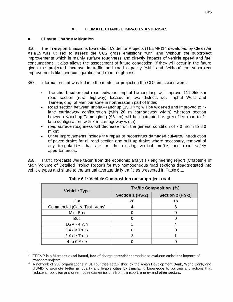
145
VI. CLIMATE CHANGE IMPACTS AND RISKS
A. Climate Change Mitigation
356. The Transport Emissions Evaluation Model for Projects (TEEMP)14 developed by Clean Air Asia 15 was utilized to assess the CO2 gross emissions ‘with’ and ‘without’ the subproject improvements which is mainly surface roughness and directly impacts of vehicle speed and fuel consumptions. It also allows the assessment of future congestion, if they will occur in the future given the projected increase in traffic and road capacity ‘with’ and ‘without’ the subproject improvements like lane configuration and road roughness. 357. Information that was fed into the model for projecting the CO2 emissions were:
Tranche 1 subproject road between Imphal-Tamenglong will improve 111.055 km road section (rural highway) located in two districts i.e. Imphal West and Tamenglong; of Manipur state in northeastern part of India;
Road section between Imphal-Kanchup (15.0 km) will be widened and improved to 4-lane carriagway configuration (with 26 m carriageway width) whereas section between Kanchup-Tamenglong (96 km) will be contrcuted as greenfiled road to 2-lane configuration (with 7 m carriageway width);
road surface roughness will decrease from the general condition of 7.0 m/km to 3.0 m/km;
Other improvements include the repair or reconstruct damaged culverts, introduction of paved drains for all road section and built up drains where necessary, removal of any irregularities that are on the existing vertical profile, and road safety appurtenances.
358. Traffic forecasts were taken from the economic analysis / engineering report (Chapter 4 of Main Volume of Detailed Project Report) for two homogeneous road sections disaggregated into vehicle types and share to the annual average daily traffic as presented in Table 6.1.
Table 6.1: Vehicle Composition on subproject road
Vehicle Type Traffic Composition (%)
Section 1 (HS-2) Section 2 (HS-2) Car 28 18
Commercial (Cars, Taxi, Vans) 4 3 Mini Bus 0 0
Bus 0 0 LGV - 4 Wh 1 4 3 Axle Truck 0 0 2 Axle Truck 3 1 4 to 6 Axle 0 0
14 TEEMP is a Microsoft excel-based, free-of-charge spreadsheet models to evaluate emissions impacts of
transport projects. 15 A network of 250 organizations in 31 countries established by the Asian Development Bank, World Bank, and
USAID to promote better air quality and livable cities by translating knowledge to policies and actions that reduce air pollution and greenhouse gas emissions from transport, energy and other sectors.
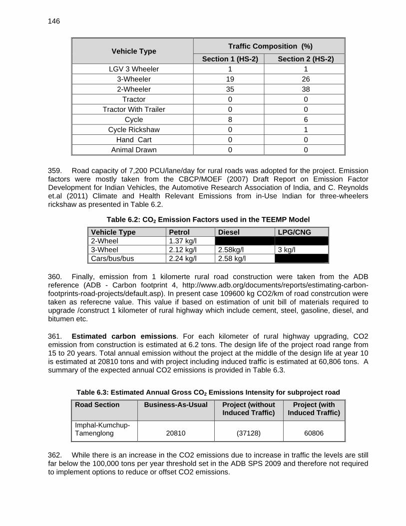
146
Vehicle Type Traffic Composition (%)
Section 1 (HS-2) Section 2 (HS-2) LGV 3 Wheeler 1 1
3-Wheeler 19 26 2-Wheeler 35 38
Tractor 0 0 Tractor With Trailer 0 0
Cycle 8 6 Cycle Rickshaw 0 1
Hand Cart 0 0 Animal Drawn 0 0
359. Road capacity of 7,200 PCU/lane/day for rural roads was adopted for the project. Emission factors were mostly taken from the CBCP/MOEF (2007) Draft Report on Emission Factor Development for Indian Vehicles, the Automotive Research Association of India, and C. Reynolds et.al (2011) Climate and Health Relevant Emissions from in-Use Indian for three-wheelers rickshaw as presented in Table 6.2.
Table 6.2: CO2 Emission Factors used in the TEEMP Model
Vehicle Type Petrol Diesel LPG/CNG 2-Wheel 1.37 kg/l 3-Wheel 2.12 kg/l 2.58kg/l 3 kg/l Cars/bus/bus 2.24 kg/l 2.58 kg/l
360. Finally, emission from 1 kilomerte rural road construction were taken from the ADB reference (ADB - Carbon footprint 4, http://www.adb.org/documents/reports/estimating-carbon-footprints-road-projects/default.asp). In present case 109600 kg CO2/km of road constrcution were taken as referecne value. This value if based on estimation of unit bill of materials required to upgrade /construct 1 kilometer of rural highway which include cement, steel, gasoline, diesel, and bitumen etc. 361. Estimated carbon emissions. For each kilometer of rural highway upgrading, CO2 emission from construction is estimated at 6.2 tons. The design life of the project road range from 15 to 20 years. Total annual emission without the project at the middle of the design life at year 10 is estimated at 20810 tons and with project including induced traffic is estimated at 60,806 tons. A summary of the expected annual CO2 emissions is provided in Table 6.3.
Table 6.3: Estimated Annual Gross CO2 Emissions Intensity for subproject road
Road Section Business-As-Usual Project (without Induced Traffic)
Project (with Induced Traffic)
Imphal-Kumchup-Tamenglong 20810 (37128) 60806
362. While there is an increase in the CO2 emissions due to increase in traffic the levels are still far below the 100,000 tons per year threshold set in the ADB SPS 2009 and therefore not required to implement options to reduce or offset CO2 emissions.
147
B. Climate Risks and Adapation Needs
363. Climate risks were identified following both top down and bottom up approaches. Under the top down approach changes of key climate parameters, mainly temperature and precipitation were projected for 2050 using an ensemble of Global Climate Models (GCMs). Given the projected variations of temperature and precipitation the subproject road were screened for 9 types of climate risks:
Landslide triggered by increased precipitation Fire Flood Drought Tsunami Cyclone wind Cyclone surge Sea level rise Coastal erosion
364. Climate risk maps based on information from the GCMs were created for the subproject area using Geographic Information System (GIS) maps. After overlaying the road locations on the climate risk maps low to medium risks identified for the subproject road were flooding, landslides triggered by precipitation, and drought. 365. Landslides triggered by precipitation. Heavy rains can cause disruption of the road network, decreased accessibility, erosion of roads and embankments, surface water drainage problems, slope failures, landslides, among others. Increased river flow resulting from precipitation and storminess may result in damages to bridges. Bridge/culvert capacities are reduced or exceeded, causing upstream flooding to occur. Seasonal variation is rainfall also causes drought in subproject areas. Section between Imphal-Kunchup is particularly vulnerable to flood and submergence risks since this is low-lying area. Flooding occurs during the rainy seasons (May to October). 366. Landslide Triggered by Precipitation. Road section between Kunchup and Tamenglong, which is basically hilly terrain with weak geology, is potentially susceptible to medium to high levels of landslide risk. 367. Droughts are also experienced in recent years in subproject areas mostly Imphal, Thoubal and also in Chandel districts of Manipur. The drought risk is low. 368. Under the bottom up approach environmental checklists were compiled on all environmental features including risks for landslides, flooding, drought for the subproject road. A combination of review of published data, field visits and public consultations were carried out to complete the environmental checklists. State/District level consultations with key stakeholders were carried out to find out information on history of flooding and drought in the project area. Through these methods information on the existing hydrology as well as meteorological data, and potential hydro-meteorological impacts that may arise from the project activities were compiled. Based on information from the subproject road specific environmental checklists, public consultations and hydro-meteorological analysis the main risks identified were flooding, landslides and drought.
148
369. The climate risks and subproject road section with risks identified using the top down and bottom up approach though not exactly the same were largely consistent. After combining the findings from the two approaches, the final list of road sections and types of risks they faced were listed. A final review of the road sections was carried out by the engineers. It was found that the risk of drought was very low. Hence, only flooding and landslide that was considered for addressing the road design. 370. Key engineering measures taken to address these risks in the design are: i) increase in embankment height in Imphal-Kunchup section, ii) construction of new side and lead away drains, iii) construction of new culverts or widening of existing ones, iv) construction of new bridges, v) construction of retaining walls, and iv) use of slope protection techniques. As shown in Table 6.4, costs for taking these measures add up to a total of US$ 42.6 million. This is approximately 29.4% of the total civil works costs. It must be pointed out that these measures would have been considered anyway in the conventional design as the issue of flooding and landslide is a threat to the sustainability of the road. However, these measures also contribute to adaptation of the road for future increases in precipitation. This risk screening and risk identification exercise has helped to ensure that subproject road has adequate climate risk mitigation or adaptation measures. The sectionwise details of climate risks, specific engineering measures taken and the costs of those measures are provided in Table 6.5.
Table 6.4: Cost of Climate Adaptation Measures (in million US$)
Section Increase Embankment Height
New side and lead away drains and Retaining walls
New/ Widening Culverts
Major Bridges
Total
Imphal-Kumchup-
Tamenglong 1.7 16.5 9.1 15.3 42.6
371. Provisions have also been made in the bidding documents for the contractor to prepare contract package specific EMP’s based on the final detailed design to address a range of issues including climate related risks and vulnerabilities such as flooding, coastal erosion, landslide and accordingly incorporate required costs in the BOQ.
149
Table 6.5: Climate Adaptation Measures and associated costs for Imphal-Kuncgup-Tamenglong Road Subproject
Road
Section Climate risk Cause of risk Adaptation measures taken in design Costs for adaptation
measures (US$) Imphal-Kumchup-Tamenglong
Damage of road due to flooding
Located in low lying areas
Raising embankment height by 1.0 m to 3m in Imphal-Kunchup section (low lying area)
1.7 million
Croosing of subproject roads
Constrcution of culverts (new culvers, widening, and rehabilitation) along Imphal-Kunchup-Tamenglong Section
9.1 million
Croosing of subproject roads
Constrcution of Major bridges along Imphal-Kunchup-Tamenglong Section
15.3 million
Croosing of subproject roads
Constrcution of draingage and protection work (turfing of embankment slopes, planting trees and shrubs, side drains (lines and unlined) etc.) along Imphal-Kunchup-Tamenglong Section
13.5 million
Damage of road due to landslides
Hilly sections along the project road
Construction of retaining walls on hill side to protect slopes along Kunchup-Tamenglong Road Section
3.0 million
150
VII. ANALYSIS OF ALTERNATIVES
A. Introduction
372. This chapter presents the symmetrically compared feasible alternatives to the proposed project with respect to site, design, technology etc. Since the Imphal-Kunchup section involves improvement of the existing road, only one alternative alignment was considered for this section. For Kunchup-Tamenglong sections, various alternate alignment options were syudies including option of a Tunnel. Besides this an evaluation has been carried out for the 'with’ and ‘without’ project situation-in terms of the potential environmental impacts for the justification of the project. This chapter discusses how environmental parameters were assigned due importance and were carefully considered in the analysis of alternatives. B. ‘With Project’ and ‘Without Project’ Scenario
1. ‘With Project’ Scenario
373. The ‘with Project’ scenario includes improvement of Imphal-Kanchup-Tamenglong road section to four/two lane carriageway configuration in Imphal West and Tamenglong districts of Manipur. The ‘with project’ scenario has been assessed to be economically viable and will alleviate the existing conditions. It would thereby, contribute to the development goals envisaged by the Government of Manipur as well as Government of India, and enhance the growth potential of the state as well as SASEC Region as well as region. 374. To avoid the large-scale acquisition of land and properties, the project envisages the widening of road to two lane and mostly along the existing tracks to minimize the loss of properties and livelihood of the PAPs.
2. ‘Without Project’ Scenario
375. In the case of ‘without project’ scenario the existing road and tracks without carriageway will be considered as it is. Considering the present traffic volume and potential for growth in near future, the capacity of the present road is insufficient for handling expected traffic volume and calls in for immediate improvements. 376. The project road provides shortest connectivity for the State of “East West Corridor” of the National Highway Authority of India. This shall also reduce the distance to Guwahati, the commercial hub of the North East, from Imphal by at least 90 (ninety) Kms as compared to the existing route via Dimapur. The alignment passes through Imphal, Kangchup, Haochong, Bhalok and Tamenglong. Tracks at certain sections between Kangchup to Haochong earlier known as KT road during British era are still being used by settlers to transport wooden logs during dry season and are accessible on foot or Shaktiman trucks only. Existing road surface has exposed rocks as it has not been maintained due to heavy rains in the region. The alignment has many settlements and rivers along its length. Alignment traverses through steep mountains towards Haochong settlement, via Waphong settlement. Existing alignment at certain section has very steep grades. Alignment passing through Waphong settlement crosses Ijei River very close to the settlement. 377. The poor road conditions, population growth, increase in traffic volumes and the economic development along the project corridor would continue to occur and will exacerbate
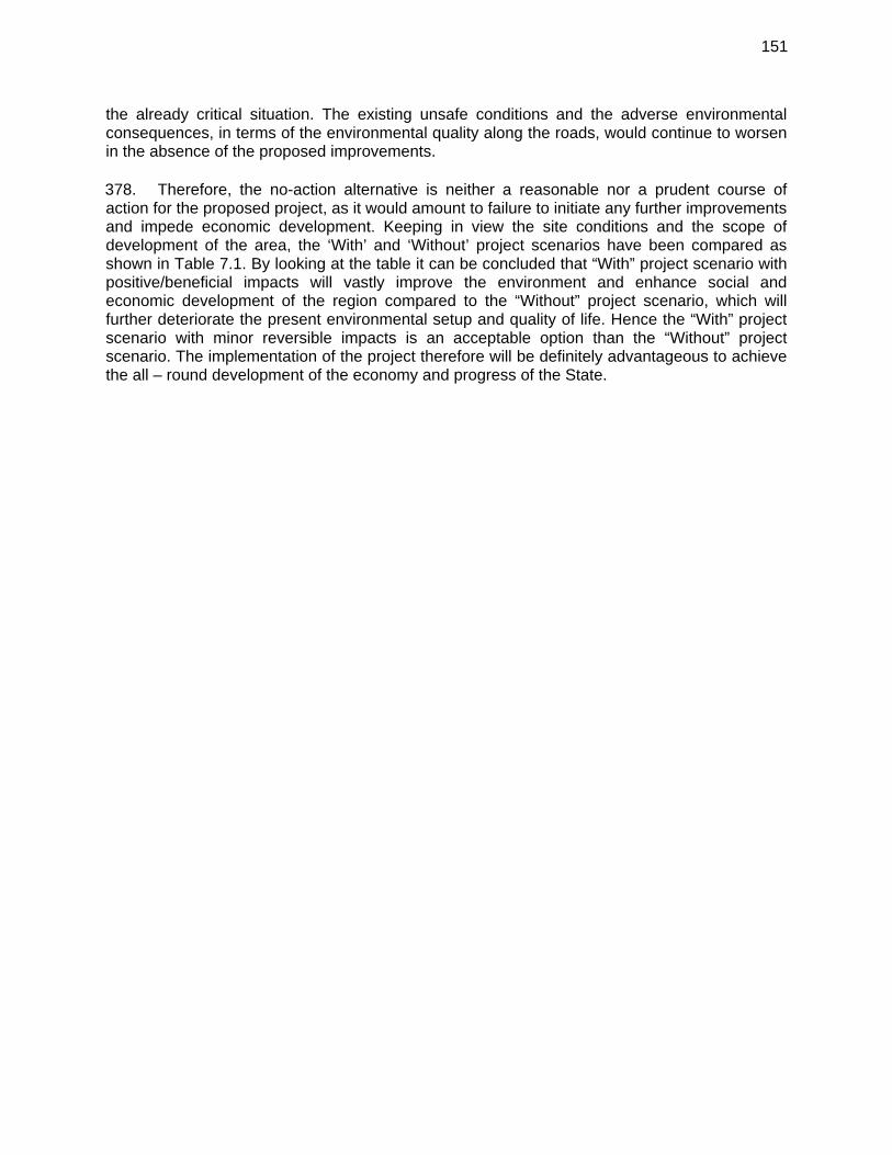
151
the already critical situation. The existing unsafe conditions and the adverse environmental consequences, in terms of the environmental quality along the roads, would continue to worsen in the absence of the proposed improvements. 378. Therefore, the no-action alternative is neither a reasonable nor a prudent course of action for the proposed project, as it would amount to failure to initiate any further improvements and impede economic development. Keeping in view the site conditions and the scope of development of the area, the ‘With’ and ‘Without’ project scenarios have been compared as shown in Table 7.1. By looking at the table it can be concluded that “With” project scenario with positive/beneficial impacts will vastly improve the environment and enhance social and economic development of the region compared to the “Without” project scenario, which will further deteriorate the present environmental setup and quality of life. Hence the “With” project scenario with minor reversible impacts is an acceptable option than the “Without” project scenario. The implementation of the project therefore will be definitely advantageous to achieve the all – round development of the economy and progress of the State.
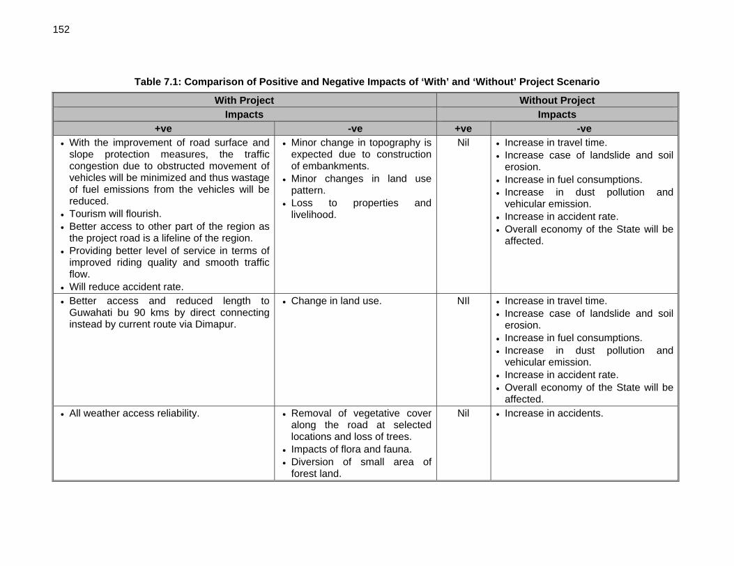
152
Table 7.1: Comparison of Positive and Negative Impacts of ‘With’ and ‘Without’ Project Scenario
With Project Without Project Impacts Impacts
+ve -ve +ve -ve With the improvement of road surface and
slope protection measures, the traffic congestion due to obstructed movement of vehicles will be minimized and thus wastage of fuel emissions from the vehicles will be reduced.
Tourism will flourish. Better access to other part of the region as
the project road is a lifeline of the region. Providing better level of service in terms of
improved riding quality and smooth traffic flow.
Will reduce accident rate.
Minor change in topography is expected due to construction of embankments.
Minor changes in land use pattern.
Loss to properties and livelihood.
Nil Increase in travel time. Increase case of landslide and soil
erosion. Increase in fuel consumptions. Increase in dust pollution and
vehicular emission. Increase in accident rate. Overall economy of the State will be
affected.
Better access and reduced length to Guwahati bu 90 kms by direct connecting instead by current route via Dimapur.
Change in land use. NIl Increase in travel time. Increase case of landslide and soil
erosion. Increase in fuel consumptions. Increase in dust pollution and
vehicular emission. Increase in accident rate. Overall economy of the State will be
affected. All weather access reliability. Removal of vegetative cover
along the road at selected locations and loss of trees.
Impacts of flora and fauna. Diversion of small area of
forest land.
Nil Increase in accidents.
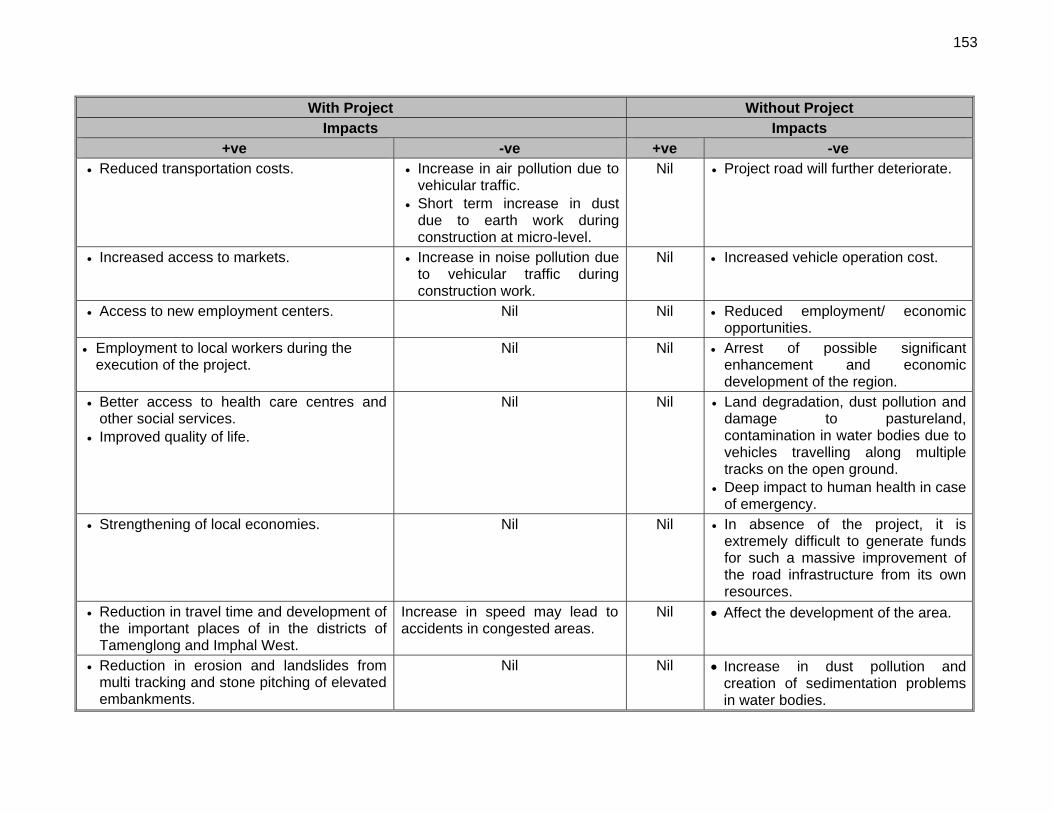
153
With Project Without Project Impacts Impacts
+ve -ve +ve -ve Reduced transportation costs. Increase in air pollution due to
vehicular traffic. Short term increase in dust
due to earth work during construction at micro-level.
Nil Project road will further deteriorate.
Increased access to markets. Increase in noise pollution due to vehicular traffic during construction work.
Nil Increased vehicle operation cost.
Access to new employment centers. Nil Nil Reduced employment/ economic opportunities.
Employment to local workers during the execution of the project.
Nil Nil Arrest of possible significant enhancement and economic development of the region.
Better access to health care centres and other social services.
Improved quality of life.
Nil Nil Land degradation, dust pollution and damage to pastureland, contamination in water bodies due to vehicles travelling along multiple tracks on the open ground.
Deep impact to human health in case of emergency.
Strengthening of local economies. Nil Nil In absence of the project, it is extremely difficult to generate funds for such a massive improvement of the road infrastructure from its own resources.
Reduction in travel time and development of the important places of in the districts of Tamenglong and Imphal West.
Increase in speed may lead to accidents in congested areas.
Nil Affect the development of the area.
Reduction in erosion and landslides from multi tracking and stone pitching of elevated embankments.
Nil Nil Increase in dust pollution and creation of sedimentation problems in water bodies.
154
With Project Without Project Impacts Impacts
+ve -ve +ve -ve The widened and paved road will reduce
impacts due to multiple tracking on soil and vegetation along the road.
Nil Nil Increased adverse impacts on soil and vegetation.
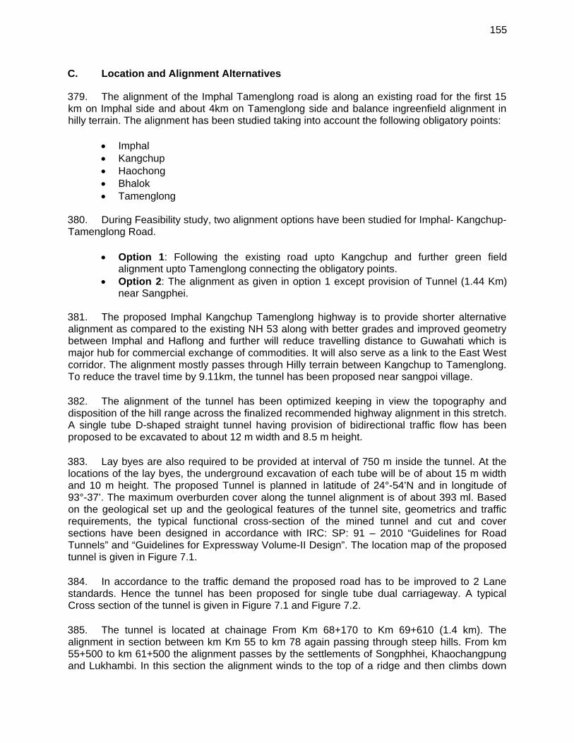
155
C. Location and Alignment Alternatives
379. The alignment of the Imphal Tamenglong road is along an existing road for the first 15 km on Imphal side and about 4km on Tamenglong side and balance ingreenfield alignment in hilly terrain. The alignment has been studied taking into account the following obligatory points:
Imphal Kangchup Haochong Bhalok Tamenglong
380. During Feasibility study, two alignment options have been studied for Imphal- Kangchup-Tamenglong Road.
Option 1: Following the existing road upto Kangchup and further green field alignment upto Tamenglong connecting the obligatory points.
Option 2: The alignment as given in option 1 except provision of Tunnel (1.44 Km) near Sangphei.
381. The proposed Imphal Kangchup Tamenglong highway is to provide shorter alternative alignment as compared to the existing NH 53 along with better grades and improved geometry between Imphal and Haflong and further will reduce travelling distance to Guwahati which is major hub for commercial exchange of commodities. It will also serve as a link to the East West corridor. The alignment mostly passes through Hilly terrain between Kangchup to Tamenglong. To reduce the travel time by 9.11km, the tunnel has been proposed near sangpoi village. 382. The alignment of the tunnel has been optimized keeping in view the topography and disposition of the hill range across the finalized recommended highway alignment in this stretch. A single tube D-shaped straight tunnel having provision of bidirectional traffic flow has been proposed to be excavated to about 12 m width and 8.5 m height. 383. Lay byes are also required to be provided at interval of 750 m inside the tunnel. At the locations of the lay byes, the underground excavation of each tube will be of about 15 m width and 10 m height. The proposed Tunnel is planned in latitude of 24°-54’N and in longitude of 93°-37’. The maximum overburden cover along the tunnel alignment is of about 393 ml. Based on the geological set up and the geological features of the tunnel site, geometrics and traffic requirements, the typical functional cross-section of the mined tunnel and cut and cover sections have been designed in accordance with IRC: SP: 91 – 2010 “Guidelines for Road Tunnels” and “Guidelines for Expressway Volume-II Design”. The location map of the proposed tunnel is given in Figure 7.1. 384. In accordance to the traffic demand the proposed road has to be improved to 2 Lane standards. Hence the tunnel has been proposed for single tube dual carriageway. A typical Cross section of the tunnel is given in Figure 7.1 and Figure 7.2. 385. The tunnel is located at chainage From Km 68+170 to Km 69+610 (1.4 km). The alignment in section between km Km 55 to km 78 again passing through steep hills. From km 55+500 to km 61+500 the alignment passes by the settlements of Songphhei, Khaochangpung and Lukhambi. In this section the alignment winds to the top of a ridge and then climbs down
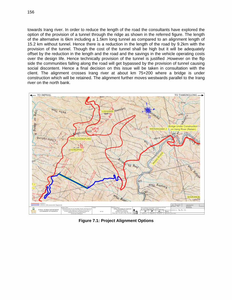
156
towards Irang river. In order to reduce the length of the road the consultants have explored the option of the provision of a tunnel through the ridge as shown in the referred figure. The length of the alternative is 6km including a 1.5km long tunnel as compared to an alignment length of 15.2 km without tunnel. Hence there is a reduction in the length of the road by 9.2km with the provision of the tunnel. Though the cost of the tunnel shall be high but it will be adequately offset by the reduction in the length and the road and the savings in the vehicle operating costs over the design life. Hence technically provision of the tunnel is justified .However on the flip side the communities falling along the road will get bypassed by the provision of tunnel causing social discontent. Hence a final decision on this issue will be taken in consultation with the client. The alignment crosses Irang river at about km 75+200 where a bridge is under construction which will be retained. The alignment further moves westwards parallel to the Irang river on the north bank.
Figure 7.1: Project Alignment Options
Prepared by Checked byDesigned by Approved by
Intercontinental Consultants & Technocrats Pvt Ltd,A-8, Green Park, New Delhi - 110016Ph : +91-11-4086-3000, Fax +91-11-2685-5252
Checked by
FILE NAME:-
RevisionsDescriptionDateRevisions
R0 Initial Drawings
DRAWING No:-
Aug-2014
Consultancy Services for Feasibility Study and Preparationof Detailed Project Report for Proposed Construction of
Greater Imphal Ring Road and Imphal KangchupTamenglong Tousem Haflong Road
in the state of Manipur
Scale:-Project Title:- Drawing Name:-
Fig. No.
Vimal Prakash Aseem Prabhakar Deepak KumarAnju
PUBLIC WORKS DEPARTMENTGOVERMENT OF MANIPUR
TO IMPHAL TO TAMENGLONG
Alignment Options(Imphal Tamenglong)
OPTION 1OPTION 2 (Recommended Alignment)
FINAL FEASIBILITY REPORT
From Km. 55+000 to Km. 68+000N.T.S.
5.6
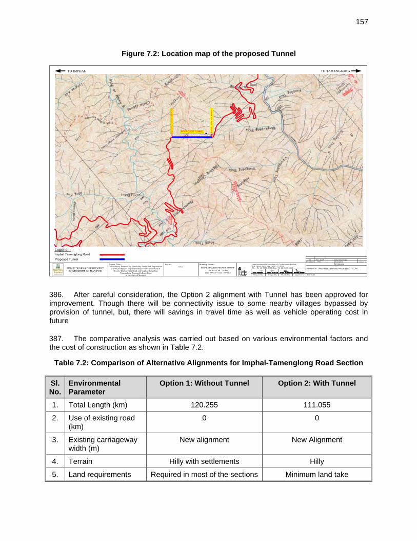
157
Figure 7.2: Location map of the proposed Tunnel
386. After careful consideration, the Option 2 alignment with Tunnel has been approved for improvement. Though there will be connectivity issue to some nearby villages bypassed by provision of tunnel, but, there will savings in travel time as well as vehicle operating cost in future 387. The comparative analysis was carried out based on various environmental factors and the cost of construction as shown in Table 7.2.
Table 7.2: Comparison of Alternative Alignments for Imphal-Tamenglong Road Section
Sl. No.
Environmental Parameter
Option 1: Without Tunnel Option 2: With Tunnel
1. Total Length (km) 120.255 111.055
2. Use of existing road (km)
0 0
3. Existing carriageway width (m)
New alignment New Alignment
4. Terrain Hilly with settlements Hilly
5. Land requirements Required in most of the sections Minimum land take
Prepared by Checked byDesigned by Approved by
Intercontinental Consultants & Technocrats Pvt Ltd,A-8, Green Park, New Delhi - 110016Ph : +91-11-4086-3000, Fax +91-11-2685-5252
Checked by
FILE NAME:-
RevisionsDescriptionDateRevisions
R0 Initial Drawings
DRAWING No:-
Nov.-2014
Consultancy Services for Feasibility Study and Preparationof Detailed Project Report for Proposed Construction of
Greater Imphal Ring Road and Imphal KangchupTamenglong Tousem Haflong Road
in the state of Manipur
Scale:-
DRAFT DETAILED PROJECT REPORT
Project Title:- Drawing Name:-
PWD/IMPHAL TAMENGLONG/TUNNEL/ /R0PUBLIC WORKS DEPARTMENTGOVERMENT OF MANIPUR
N.T.S.
TO IMPHAL TO TAMENGLONG
LAYOUT PLAN - TUNNEL(Km. 68+170 to Km. 69+610)
01
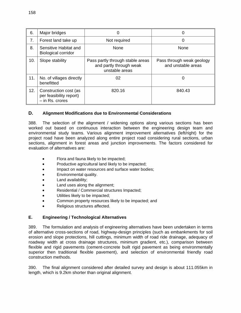
158
6. Major bridges 0 0
7. Forest land take up Not required 0
8. Sensitive Habitat and Biological corridor
None None
10. Slope stability Pass partly through stable areas and partly through weak
unstable areas
Pass through weak geology and unstable areas
11. No. of villages directly benefitted
02 0
12. Construction cost (as per feasibility report) – in Rs. crores
820.16 840.43
D. Alignment Modifications due to Environmental Considerations
388. The selection of the alignment / widening options along various sections has been worked out based on continuous interaction between the engineering design team and environmental study teams. Various alignment improvement alternatives (left/right) for the project road have been analyzed along entire project road considering rural sections, urban sections, alignment in forest areas and junction improvements. The factors considered for evaluation of alternatives are:
Flora and fauna likely to be impacted; Productive agricultural land likely to be impacted; Impact on water resources and surface water bodies; Environmental quality. Land availability; Land uses along the alignment; Residential / Commercial structures Impacted; Utilities likely to be impacted; Common property resources likely to be impacted; and Religious structures affected.
E. Engineering / Technological Alternatives
389. The formulation and analysis of engineering alternatives have been undertaken in terms of alternative cross-sections of road, highway-design principles (such as embankments for soil erosion and slope protections, hill cuttings, minimum width of road ride drainage, adequacy of roadway width at cross drainage structures, minimum gradient, etc.), comparison between flexible and rigid pavements (cement-concrete built rigid pavement as being environmentally superior then traditional flexible pavement), and selection of environmental friendly road construction methods. 390. The final alignment considered after detailed survey and design is about 111.055km in length, which is 9.2km shorter than original alignment.
159
VIII. PUBLIC CONSULTATION AND INFORMATION DISCLOSURE
391. In accordance with ADB’s Safeguard Policy Statement (SPS) 2009 and Environment Impact Assessment Notification of GoI (2006), public consultations were held, as part of environment assessment study. The consultation undertaken with project beneficiaries, local/ government officials, community leaders, non-government organizations (NGO’s), stakeholders in the corridor of impact and people likely to be effected due to the project on various issues affecting them and incorporation of various measures pertaining to environmental issues based on the responses from the people.
A. Objectives of Consultations
392. The process of public participation/ consultations was taken up as an integral part of the project in accordance with environmental assessment requirements. The objectives of these consultations are:
To inform and educate the general public, specially potentially impacted communities/ individuals and stakeholders about the proposed project activities;
To familiarize the people with technical, environmental, social and economic issues of the project for better understanding;
To solicit the opinion of the affected communities/ individuals on environmental
issues and assess the significance of impacts due to the proposed development;
To foster co-operation among officers of PWD, the communities and the stakeholders to achieve a cordial working relationship for smooth implementation of the project;
To identify the environmental issues relating to the road improvement work;
Assess the views of the beneficiary communities and their willingness to participate
in the project in a bottom up planning and decision making process;
To secure people’s inputs in respect of project planning, selection of mitigation measures and monitoring strategies;
To ensure lessening of public resistance to change by providing them a platform in
the decision making process;
To inculcate the sense of belongingness among the public about the project. B. Methodology used for Consultations
393. Both formal and informal modes of consultation were used in the public consultation process for the project. Consultation with the stakeholders, beneficiaries, and community leaders were carried out using standard structured questionnaires as well as unstructured questionnaires. In addition, focused ground discussions (FGDs) and personal discussions with officials, on-site discussion with project affected stakeholders, and reconnaissance visits have also been made to the project area. The attempts were made to encourage participation in the
160
consultation process of the government officials from different departments that have relevance to the project. Same way, local people from different socio economic backgrounds in the villages as well as urban areas along the road alignment and at detours, women, residents near the existing road, local commuters, and other concerned were also consulted. C. Identification of Stakeholders
394. Stakeholders were identified to ensure as wide coverage as possible of the project area as follows:
Households in the project area including potential Project Affected Persons, Women groups, Local, regional and international voluntary organisations / non-government
organizations (NGOs), Government agencies, and Community leaders.
395. Questionnaire survey/ discussions were designed to obtain background information and details of general environmental issues that concern people in the project area. In addition, environmental issues were discussed with relevant organizations, government officials, beneficiaries, community leaders, women groups and experts. 396. In compliance with ADB’s SPS requirements consultations will be continued throughout the project planning, design and implementation phase. The consultation process initiated during preparation of the EIA study. The official consultation with the key stakeholders was undertaken in the months of April 2014 to December 2014 at respective district offices and head quarter in Imphal. Various officials consulted include PWD Officials, Officials from Department of Environment (Manipur), Forest Officers, Wildlife Officials, Environmental Officers from pollution control board, statistical officer, officials from NGOs active in the project areas etc. Various issues discussed are:
Statistics of forests cover in the State and its legal status i.e. Reserved, Protected, Unclassed;
Protected area network of Manipur, Applicability of various laws and regulations to the present road development project; Requirements of Forest Department to carryout project activities within forest
/protected areas; Flora and Fauna and endangered species in the State and project area in particular; Scope of the proposed road development, EIA and likely impacts on flora & fauna; Major threats to flora & fauna in the state; Applicability of EIA notiifcation to the proposed project; Procedure to get clearance from forest department and NOC from pollution control
board; Environmental quality parameters i.e. air, water, noise quality in the State and major
sources of pollution; Institutional capacity of state authorities in pollution control and environmental
management; Socio-economic conditions and likely impacts on due to proposed road improvement;
161
397. The list of officials/ people contacted along with the venue, issues raised, date of consultation is presented on Table 8.1.
Table 8.1: List of Officials Consulted & Issues Discussed During Field Visit
Sl. No.
Name of Official Consulted
Department Issue discussed
1. Mr. Neeraj Verma
Joint Secretary, Ministry of Road Transport and Highway, Government of India, New Delhi
Scope of the work, implementation arrangement, policy and regulatory requirements from environmental point of view.
2. Mr. Kh. Temba Singh
Addl. Chief Engineer-II PWD, Manipur, Imphal
Overall scope of the Project, existing conditions of Imphal-Moreh NH section in Manipur, implementation arrangement, existing capacity of PWD, Major problems of NH, treatment to landslides
3. Mr. Y. Joykumar Singh
Project Director, NESRIP, PWD Manipur, Imphal
Existing conditions of state road, Major problems of state roads, clearances /permits requirements, Treatment to landslides
4. Th. Ibobi Singh, IFS
Additional PCCF (Wild Life) and Chief Wildlife Warden, Forest Department, Govt. of Manipur, Imphal
Scope of EIA, Impacts on wildlife and forest, Wildlife status in state, flora & fauna species, environmental aspects of hilly roads, regulatory requirements of Manipur and GOI for the implementation of the Project.
5. Mr. A.K. Rana PCCF, Forest Department, Govt. of Manipur, Imphal
Scope of EIA, Impacts on wildlife and forest, Wildlife status in state, flora & fauna species, environmental aspects of hilly roads, regulatory requirements of Manipur and GOI for the implementation of the Project.
6. Mr. L. Joukumar Singh, IFS
Dy. Conservator of Forests (Wildlife), National Parks and Sanctuaries Division, Forest Department, Government of Manipur, Imphal
Scope of EIA, Impacts on Wildlife and forest, Wildlife status in state, flora & fauna species, Environmental aspects of hilly roads
7. Mr. Dhananjay, IFS
Chief Conservator of Forests, Forest Department, Manipur, Imphal
Details of Flora & Fauna, Forest Resources, Scope of IEE, potential impacts due to proposed project

162
Sl. No.
Name of Official Consulted
Department Issue discussed
8. Mr. Mahendra Pratap, IFS
Conservator of Forests, Forest Department, Manipur, Imphal
Details of Flora & Fauna, Forest Resources, Scope of IEE, potential impacts due to proposed project
9. Mr. K. Jagadishwar Singh, IFS
Member Secretary, Manipur Pollution Control Board (MPCB), Lamphalpat, Imphal
Applicability of MPCB requirements for the currently road development project. Ambient air quality monitoring network in Manipur and existing environmental quality in Manipur.
10. Mr. W. Roshan Singh
Assistant Environmental Engineer, MPCB, Lamphalpat, Imphal
Ambient air quality monitoring network in Manipur and existing environmental quality in Manipur.
11. Mr. Khumanthem Tomba Singh
Scientist C, MPCB, Lamphalpat, Imphal
Environmental quality monitoring for along project road section. Existing environmental quality in Manipur.
12. Dr. T. Brijakumar Singh
Research Officer, Directorate of Environment, Government of Manipur, Imphal
Environmental issues in the project areas. Biodiversity studies in the project areas. Flora and fauna species.
13. Dr. N. Sana Macha
Investigator, Directorate of Environment, Government of Manipur, Imphal
Environmental issues in the project areas. Biodiversity studies in the project areas. Flora and fauna species.
14. Dr. H. Nandiram Sharma
Rtd. HOD, PG Dean College, President Science Teacher forum, Manipur
Environmental issues in the project areas. Research projects on biodiversity.
15. Dr. Vinay Kumar
Associate Professor, Deptt. Of Life Sciences, Manipur University, Imphal
Environmental quality and issues in the project areas. Research projects on biodiversity.
16. Dr. Sharma
Professor, Deptt. Of Life Sciences, Manipur University, Imphal
Environmental quality and issues in the project areas. Research projects on biodiversity.
17. Mr. RajKumar Birjit Singh
State coordinator, Indian Bird Conservation Network (IBCN), Ningthoukhong, Bishnupur, Manipur
IBCN activities in Manipur, biodiversity issued in Manipur, bird conservations programs in Yangoupokpoi Lokchao Wildlife Sanctuary, presence of threaten/endangered/vulnerable species of birds and wilier in Yangoupokpoi Lokchao
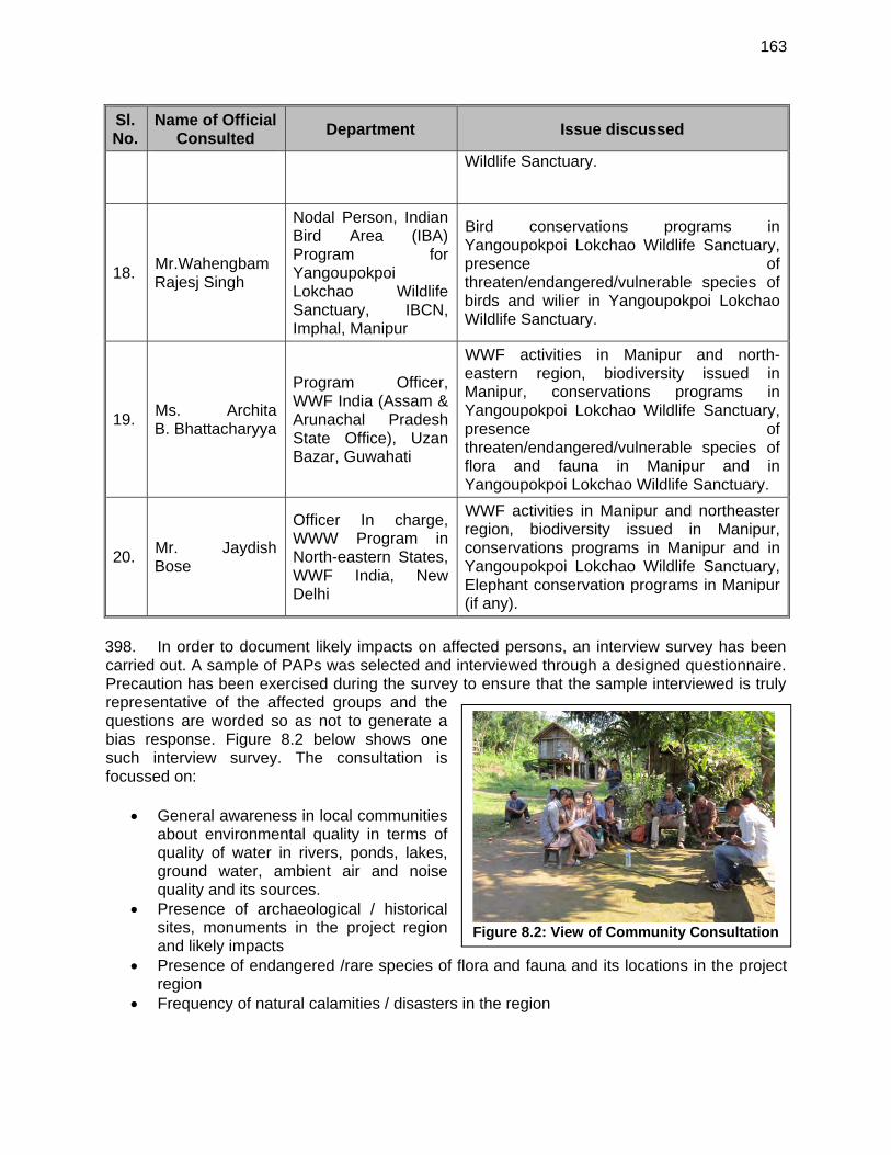
163
Figure 8.2: View of Community Consultation
Sl. No.
Name of Official Consulted
Department Issue discussed
Wildlife Sanctuary.
18. Mr.Wahengbam Rajesj Singh
Nodal Person, Indian Bird Area (IBA) Program for Yangoupokpoi Lokchao Wildlife Sanctuary, IBCN, Imphal, Manipur
Bird conservations programs in Yangoupokpoi Lokchao Wildlife Sanctuary, presence of threaten/endangered/vulnerable species of birds and wilier in Yangoupokpoi Lokchao Wildlife Sanctuary.
19. Ms. Archita B. Bhattacharyya
Program Officer, WWF India (Assam & Arunachal Pradesh State Office), Uzan Bazar, Guwahati
WWF activities in Manipur and north-eastern region, biodiversity issued in Manipur, conservations programs in Yangoupokpoi Lokchao Wildlife Sanctuary, presence of threaten/endangered/vulnerable species of flora and fauna in Manipur and in Yangoupokpoi Lokchao Wildlife Sanctuary.
20. Mr. Jaydish Bose
Officer In charge, WWW Program in North-eastern States, WWF India, New Delhi
WWF activities in Manipur and northeaster region, biodiversity issued in Manipur, conservations programs in Manipur and in Yangoupokpoi Lokchao Wildlife Sanctuary, Elephant conservation programs in Manipur (if any).
398. In order to document likely impacts on affected persons, an interview survey has been carried out. A sample of PAPs was selected and interviewed through a designed questionnaire. Precaution has been exercised during the survey to ensure that the sample interviewed is truly representative of the affected groups and the questions are worded so as not to generate a bias response. Figure 8.2 below shows one such interview survey. The consultation is focussed on:
General awareness in local communities about environmental quality in terms of quality of water in rivers, ponds, lakes, ground water, ambient air and noise quality and its sources.
Presence of archaeological / historical sites, monuments in the project region and likely impacts
Presence of endangered /rare species of flora and fauna and its locations in the project region
Frequency of natural calamities / disasters in the region
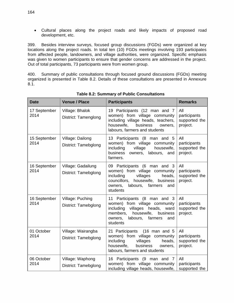
164
Cultural places along the project roads and likely impacts of proposed road development, etc.
399. Besides interview surveys, focused group discussions (FGDs) were organized at key locations along the project roads. In total ten (10) FGDs meetings involving 193 participates from affected people, landowners, and village authorities, were organized. Specific emphasis was given to women participants to ensure that gender concerns are addressed in the project. Out of total participants, 73 participants were from women group. 400. Summary of public consultations through focused ground discussions (FGDs) meeting organized is presented in Table 8.2. Details of these consultations are presented in Annexure 8.1.
Table 8.2: Summary of Public Consultations
Date Venue / Place Participants Remarks
17 September 2014
Village: Bhalok
District: Tamenglong
19 Participants (12 man and 7 women) from village community including village heads, teachers, housewife, business owners, labours, farmers and students
All participants supported the project.
15 September 2014
Village: Dailong
District: Tamebglong
13 Participants (8 man and 5 women) from village community including village housewife, business owners, labours, and farmers.
All participants supported the project.
16 September 2014
Village: Gadailung
District: Tamebglong
09 Participants (6 man and 3 women) from village community including villages heads, councillors, housewife, business owners, labours, farmers and students
All participants supported the project.
16 September 2014
Village: Puching
District: Tamebglong
11 Participants (8 man and 3 women) from village community including villages heads, ward members, housewife, business owners, labours, farmers and students
All participants supported the project.
01 October 2014
Village: Wairangba
District: Tamebglong
21 Participants (16 man and 5 women) from village community including villages heads, housewife, business owners, labours, farmers and students
All participants supported the project.
06 October 2014
Village: Waphong
District: Tamebglong
16 Participants (9 man and 7 women) from village community including village heads, housewife,
All participants supported the
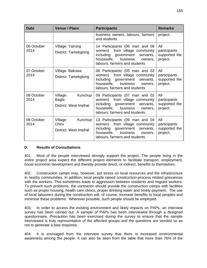
165
Date Venue / Place Participants Remarks
business owners, labours, farmers and students
project.
06 October 2014
Village: Yairong
District: Tamebglong
14 Participants (06 man and 08 women) from village community including government servants, housewife, business owners, labours, farmers and students
All participants supported the project.
07 October 2014
Village: Bakuwa
District: Tamebglong
08 Participants (05 man and 03 women) from village community including government servants, housewife, business owners, labours, farmers and students
All participants supported the project.
08 October 2014
Village: Kunchup Bagla
District: West Imphal
09 Participants (07 man and 02 women) from village community including government servants, housewife, business owners, labours, farmers and students
All participants supported the project.
08 October 2014
Village: Kunchup Chiru
District: West Imphal
13 Participants (09 man and 04 women) from village community including government servants, housewife, business owners, labours, farmers and students
All participants supported the project.
D. Results of Consultations
401. Most of the people interviewed strongly support the project. The people living in the entire project area expect the different project elements to facilitate transport, employment, boost economic development and thereby provide direct, or indirect, benefits to themselves. 402. Construction camps may, however, put stress on local resources and the infrastructure in nearby communities. In addition, local people raised construction-process related grievances with the workers. This sometimes leads to aggression between residents and migrant workers. To prevent such problems, the contractor should provide the construction camps with facilities such as proper housing, health care clinics, proper drinking water and timely payment. The use of local labourers during the construction will, of course, increase benefits to local peoples and minimise these problems. Wherever possible, such people should be employed. 403. In order to access the existing environment and likely impacts on PAPs, an interview survey has been carried out. A sample of PAPs has been interviewed through a designed questionnaire. Precaution has been exercised during the survey to ensure that the sample interviewed is truly representative of the affected groups and the questions are worded so as not to generate a bias response. 404. It is envisaged from the interview survey that there is increased environmental awareness among the people. It can also be seen from the table that more than 76% of the
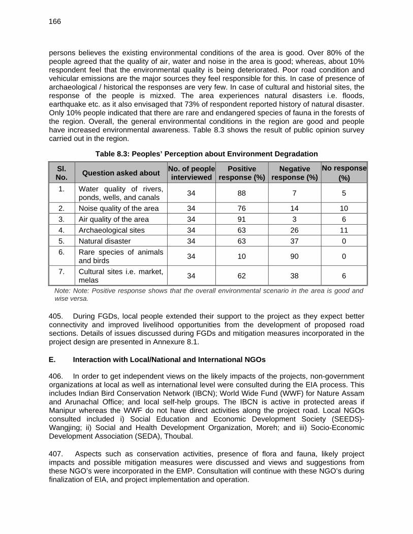
166
persons believes the existing environmental conditions of the area is good. Over 80% of the people agreed that the quality of air, water and noise in the area is good; whereas, about 10% respondent feel that the environmental quality is being deteriorated. Poor road condition and vehicular emissions are the major sources they feel responsible for this. In case of presence of archaeological / historical the responses are very few. In case of cultural and historial sites, the response of the people is mizxed. The area experiences natural disasters i.e. floods, earthquake etc. as it also envisaged that 73% of respondent reported history of natural disaster. Only 10% people indicated that there are rare and endangered species of fauna in the forests of the region. Overall, the general environmental conditions in the region are good and people have increased environmental awareness. Table 8.3 shows the result of public opinion survey carried out in the region.
Table 8.3: Peoples’ Perception about Environment Degradation
Sl. No.
Question asked about No. of people interviewed
Positive response (%)
Negative response (%)
No response(%)
1. Water quality of rivers, ponds, wells, and canals
34 88 7 5
2. Noise quality of the area 34 76 14 10
3. Air quality of the area 34 91 3 6
4. Archaeological sites 34 63 26 11
5. Natural disaster 34 63 37 0
6. Rare species of animals and birds
34 10 90 0
7. Cultural sites i.e. market, melas
34 62 38 6
Note: Note: Positive response shows that the overall environmental scenario in the area is good and wise versa.
405. During FGDs, local people extended their support to the project as they expect better connectivity and improved livelihood opportunities from the development of proposed road sections. Details of issues discussed during FGDs and mitigation measures incorporated in the project design are presented in Annexure 8.1. E. Interaction with Local/National and International NGOs
406. In order to get independent views on the likely impacts of the projects, non-government organizations at local as well as international level were consulted during the EIA process. This includes Indian Bird Conservation Network (IBCN); World Wide Fund (WWF) for Nature Assam and Arunachal Office; and local self-help groups. The IBCN is active in protected areas if Manipur whereas the WWF do not have direct activities along the project road. Local NGOs consulted included i) Social Education and Economic Development Society (SEEDS)- Wangjing; ii) Social and Health Development Organization, Moreh; and iii) Socio-Economic Development Association (SEDA), Thoubal. 407. Aspects such as conservation activities, presence of flora and fauna, likely project impacts and possible mitigation measures were discussed and views and suggestions from these NGO’s were incorporated in the EMP. Consultation will continue with these NGO’s during finalization of EIA, and project implementation and operation.
167
F. Public Disclosure
408. The project EA will be responsible for the disclosure of this EIA in compliance to ADB’s Communication Policy 2011 and ADB SPS 2009. The draft Environmental Impact Assessment Report will be disclosed in the English language in the office of PWD. The report will also be made available to interested parties on request from the office of the PWD. Since this is Category A subproject, this draft EIA report will be disclosed to the public through the ADB website, 120 days before the approval of the respective tranche for ADB financing. This draft EIA report will also be made available to all stakeholders as part of the consultation process required under the SPS 2009.
168
IX. ENVIRONMENTAL MANAGEMENT PLAN AND GRIEVANCE REDRESS
MECHANISM
A. Introduction
409. The Environmental Management Plan (EMP) is the synthesis of all proposed mitigation and monitoring actions, set to a time-frame with specific responsibility assigned and follow-up actions defined. It contains all the information for the proponent, the contractor and the regulatory agencies to implement the project within a specified time-frame 410. This EMP consists of a set of mitigation, monitoring and institutional measures to be taken for the project to avoid, minimize and mitigate adverse environmental impacts and enhance positive impacts. The plan also includes the actions needed for the implementation of these measures. The major components of the Environmental Management Plan are:
Mitigation of potentially adverse impacts; monitoring of EMP implementation during project implementation and operation; and Institutional arrangements to implement the EMP.
B. Objectives of Environmental Management Plan
411. The main objectives of this EMP are:
To ensure compliance with Asian Development Bank’s applicable safeguard policies, and regulatory requirements of Manipur and the Government of India;
To formulate avoidance, mitigation and compensation measures for anticipated adverse environmental impacts during construction and operation, and ensure that environmentally sound, sustainable and good practices are adopted;
To stipulate monitoring and institutional requirements for ensuring safeguard compliance; and
The project road should be environmentally sustainable.
C. Impacts and Mitigation Measures
412. The identified environmental issues and suggested mitigation measures with institutional arrangements for implementation, supervision and monitoring have been provided in a matrix format in Table 9.3. However, anticipated potential impacts and suggested mitigation measures specific to this project are summarised in following paragraphs. These mitigation measures will be implemented as part of this project.
1. Impacts
413. Following are anticipated potential adverse environmental impacts: Impacts due to acquisition of about 291 hactare of land for new alignment, Impacts on surrounding area due to tree cutting (2732) for the proposed
improvement work; Impacts do to diversion of about 18 hectare of forest land for non-forest purpose; Temporary impact on land and air environment due to locating construction camp;
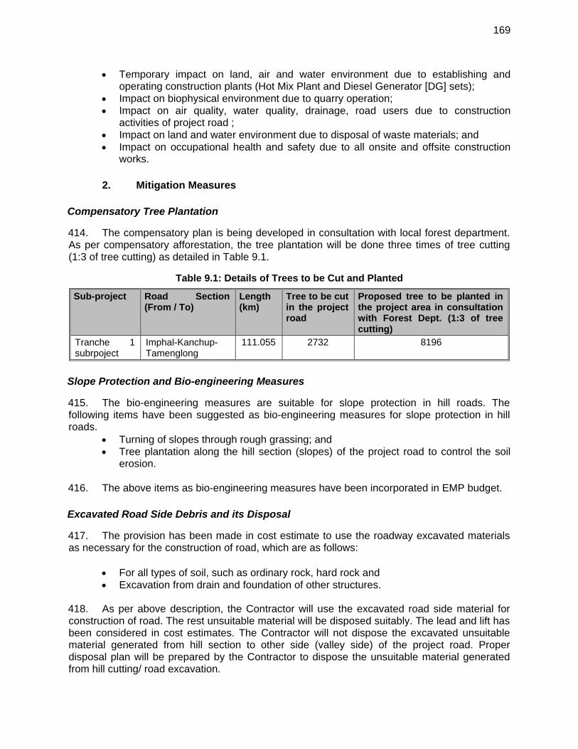
169
Temporary impact on land, air and water environment due to establishing and operating construction plants (Hot Mix Plant and Diesel Generator [DG] sets);
Impact on biophysical environment due to quarry operation; Impact on air quality, water quality, drainage, road users due to construction
activities of project road ; Impact on land and water environment due to disposal of waste materials; and Impact on occupational health and safety due to all onsite and offsite construction
works.
2. Mitigation Measures
Compensatory Tree Plantation
414. The compensatory plan is being developed in consultation with local forest department. As per compensatory afforestation, the tree plantation will be done three times of tree cutting (1:3 of tree cutting) as detailed in Table 9.1.
Table 9.1: Details of Trees to be Cut and Planted
Sub-project Road Section (From / To)
Length (km)
Tree to be cut in the project road
Proposed tree to be planted in the project area in consultation with Forest Dept. (1:3 of tree cutting)
Tranche 1 subrpoject
Imphal-Kanchup-Tamenglong
111.055 2732 8196
Slope Protection and Bio-engineering Measures
415. The bio-engineering measures are suitable for slope protection in hill roads. The following items have been suggested as bio-engineering measures for slope protection in hill roads.
Turning of slopes through rough grassing; and Tree plantation along the hill section (slopes) of the project road to control the soil
erosion. 416. The above items as bio-engineering measures have been incorporated in EMP budget.
Excavated Road Side Debris and its Disposal
417. The provision has been made in cost estimate to use the roadway excavated materials as necessary for the construction of road, which are as follows:
For all types of soil, such as ordinary rock, hard rock and Excavation from drain and foundation of other structures.
418. As per above description, the Contractor will use the excavated road side material for construction of road. The rest unsuitable material will be disposed suitably. The lead and lift has been considered in cost estimates. The Contractor will not dispose the excavated unsuitable material generated from hill section to other side (valley side) of the project road. Proper disposal plan will be prepared by the Contractor to dispose the unsuitable material generated from hill cutting/ road excavation.
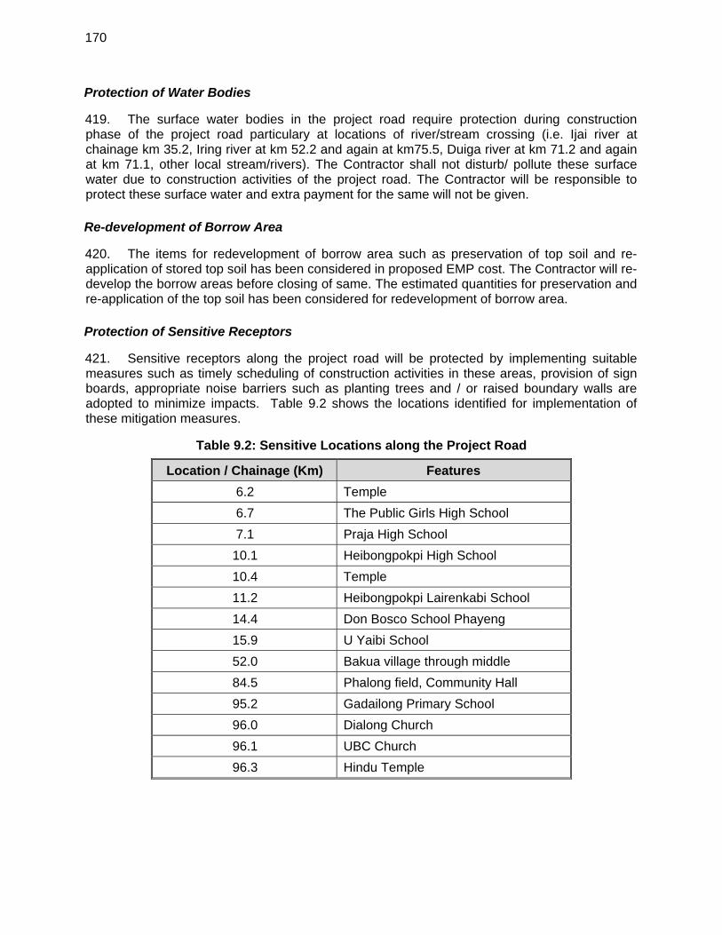
170
Protection of Water Bodies
419. The surface water bodies in the project road require protection during construction phase of the project road particulary at locations of river/stream crossing (i.e. Ijai river at chainage km 35.2, Iring river at km 52.2 and again at km75.5, Duiga river at km 71.2 and again at km 71.1, other local stream/rivers). The Contractor shall not disturb/ pollute these surface water due to construction activities of the project road. The Contractor will be responsible to protect these surface water and extra payment for the same will not be given.
Re-development of Borrow Area
420. The items for redevelopment of borrow area such as preservation of top soil and re-application of stored top soil has been considered in proposed EMP cost. The Contractor will re-develop the borrow areas before closing of same. The estimated quantities for preservation and re-application of the top soil has been considered for redevelopment of borrow area.
Protection of Sensitive Receptors
421. Sensitive receptors along the project road will be protected by implementing suitable measures such as timely scheduling of construction activities in these areas, provision of sign boards, appropriate noise barriers such as planting trees and / or raised boundary walls are adopted to minimize impacts. Table 9.2 shows the locations identified for implementation of these mitigation measures.
Table 9.2: Sensitive Locations along the Project Road
Location / Chainage (Km) Features
6.2 Temple
6.7 The Public Girls High School
7.1 Praja High School
10.1 Heibongpokpi High School
10.4 Temple
11.2 Heibongpokpi Lairenkabi School
14.4 Don Bosco School Phayeng
15.9 U Yaibi School
52.0 Bakua village through middle
84.5 Phalong field, Community Hall
95.2 Gadailong Primary School
96.0 Dialong Church
96.1 UBC Church
96.3 Hindu Temple
171
D. Environmental Monitoring and Reporting Program 422. Environmental monitoring is an essential tool for environmental management as it provides the basic information for rational management decisions. To ensure the effective implementation of mitigation measures and environmental management plan during construction and operation phase of the up gradation of subproject road, it is essential that an effective Environmental Monitoring Plan be designed and followed. 423. Environmental monitoring program has the underlying objective to ensure that the intended environmental mitigations are realized and these results in desired benefits to the target population causing minimal deterioration to the environmental parameters. Such program targets proper implementation of the EMP. The broad objectives are:
To evaluate the performance of mitigation measures proposed in the EMP. To evaluate the adequacy of environmental assessment. To suggest ongoing improvements in management plan based on the monitoring and
to devise fresh monitoring on the basis of the improved EMP. To enhance environmental quality through proper implementation of suggested
mitigation measures. To meet the requirements of the existing environmental regulatory framework and
community obligations. 1. Performance Indicators
424. The significant physical, biological and social components affecting the environment at critical locations serve as wider/overall Performance Indicators. However, the following specific environmental parameters can be quantitatively measured and compared over a period of time and are, therefore, selected as specific Performance Indicators (PIs) for monitoring because of their regulatory importance and the availability of standardized procedures and relevant expertise.
Air Quality with respect to PM2.5, PM10, CO, NOx and SO2 at selected location. Water Quality with reference to DO, BOD, Oil and grease, COD, Suspended Solids
and Turbidity, Alkalinity at crossing points on rivers/streams at selected points. Noise levels at sensitive receptors (schools, hospitals, community/religious places). Survival rates of trees planted as compensatory plantation to compensate for lost
forestlands and compensatory plantation raised for removal of roadside trees. Ambient Air Quality (AAQ) Monitoring 425. Ambient air quality parameters recommended for monitoring road development projects are PM2.5, PM10, Carbon Monoxide (CO), Oxides of Nitrogen (NOx) and Sulphur Dioxide (SO2). These are to be monitored, right from the commencement of construction activity at selected locations of plants and machinery, crushers on sites, excavation works etc. Data should be generated once in a season excluding monsoon at the monitoring locations in accordance with the revised National Ambient Air Quality Standards formulated by MoEF in 2009 (Annexure-3.3). Water Quality Monitoring 426. The physical and chemical parameters recommended for analysis of water quality relevant to road development projects are pH, total solids, total dissolved solids, total
172
suspended solids, oil and grease, COD, Chloride, Lead, Zinc and Cadmium. The location, duration and the pollution parameters to be monitored and the responsible institutional arrangements are given in the Environmental Monitoring Plan. The monitoring of the water quality is to be carried out at locations identified along the project road during construction and operation phase. The Indian Standard Specifications – IS10500: 1991 is given in Annexure – 3.2. Noise Level Monitoring 427. The measurements for monitoring noise levels would be carried out at sensitive receptors and construction sites along the project road. The Ambient Noise Standards formulated by Central Pollution Control Board (CPCB) in 1989 or the standards by State Pollution Control Board of Manipur if such standards are stringent than those of the CPCB are to be complied. The CPCB standards are given in Annexure – 3.4. Sound pressure levels would be monitored on twenty-four hour basis. Noise should be recorded at “A” weighted frequency using a “slow time response mode” of the measuring instrument. Success of Re-vegetation 428. The project involves widening and up-gradation including construction of cross drainage structures, hence these will require felling of trees. Such lost vegetation will be required to be replaced by compensatory plantation. As per policy of the State Government 03 trees have to be planted for each tree removed. These compensatory plantations will have to be monitored by the implementing agency with the help of the Forest Department. Such monitoring will be conducted through random samples. Such sampling should cover at least 5% of the area planted up. E. Environmental Reporting System
429. The monitoring plan covering various performance indicators, frequency and institutional arrangements of the project in the construction and operation stages, along with the estimated cost, is summarized in Table 9.4. 430. The reporting system will operate linearly with the contractor who is at the lowest rank of the implementation system reporting to the CSC, who in turn shall report to the PIU. All reporting by the contractor and CSC shall be on a quarterly basis. The PIU shall be responsible for preparing targets for each of the identified EMP activities. 431. The compliance monitoring and the progress reports on environmental components may be clubbed together and submitted to the PIU quarterly during the implementation period. The operation stage monitoring reports may be annual or biannual provided the Project Environmental Completion Report shows that the implementation was satisfactory. Otherwise, the operation stage monitoring reports will have to be prepared as specified in the said Project Environmental Completion Report. 432. Responsibilities for overseeing will rest with the CSC’s staff reporting to the PIU. Capacity to quantitatively monitor relevant ecological parameters would be an advantage but monitoring will primarily involve ensuring that actions taken are in accordance with contract and specification clauses, and specified mitigation measures as per the EMP.
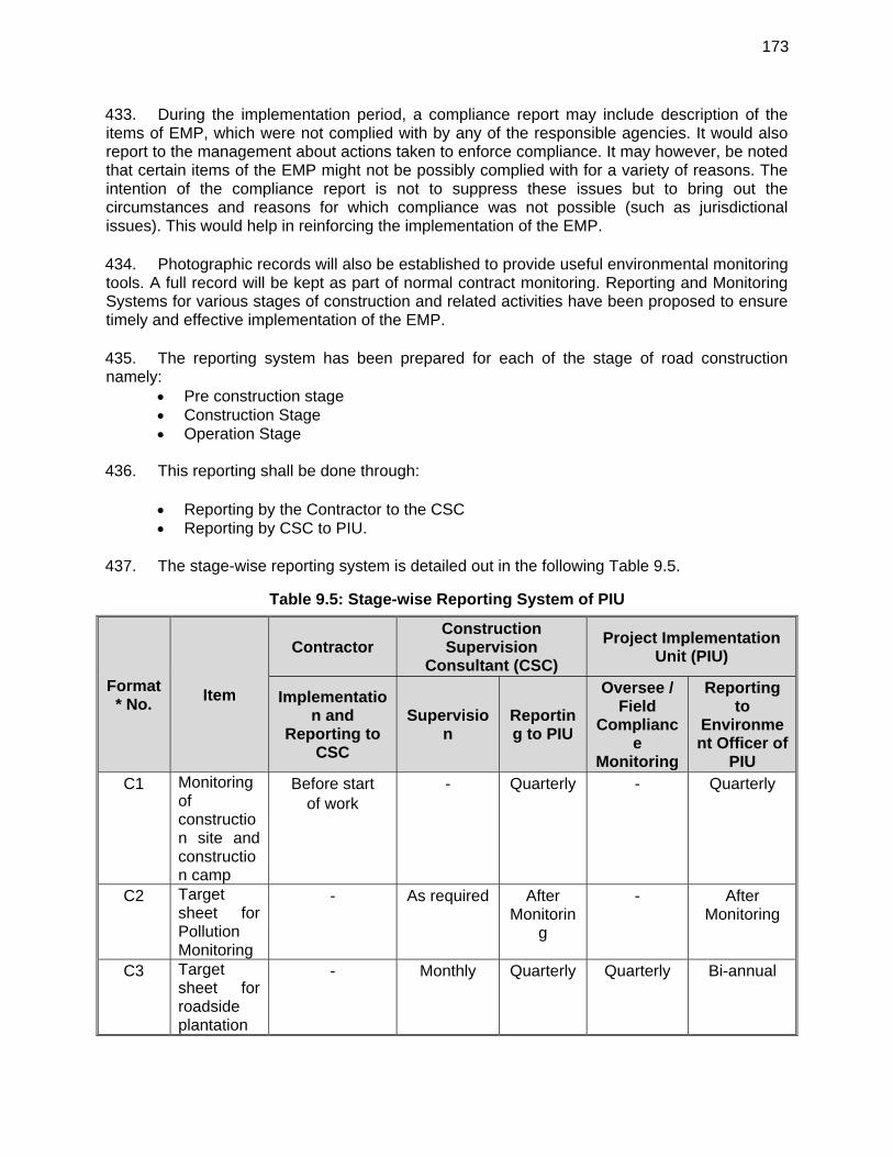
173
433. During the implementation period, a compliance report may include description of the items of EMP, which were not complied with by any of the responsible agencies. It would also report to the management about actions taken to enforce compliance. It may however, be noted that certain items of the EMP might not be possibly complied with for a variety of reasons. The intention of the compliance report is not to suppress these issues but to bring out the circumstances and reasons for which compliance was not possible (such as jurisdictional issues). This would help in reinforcing the implementation of the EMP. 434. Photographic records will also be established to provide useful environmental monitoring tools. A full record will be kept as part of normal contract monitoring. Reporting and Monitoring Systems for various stages of construction and related activities have been proposed to ensure timely and effective implementation of the EMP. 435. The reporting system has been prepared for each of the stage of road construction namely:
Pre construction stage Construction Stage Operation Stage
436. This reporting shall be done through:
Reporting by the Contractor to the CSC Reporting by CSC to PIU.
437. The stage-wise reporting system is detailed out in the following Table 9.5.
Table 9.5: Stage-wise Reporting System of PIU
Format* No.
Item
Contractor Construction Supervision
Consultant (CSC)
Project Implementation Unit (PIU)
Implementation and
Reporting to CSC
Supervision
Reporting to PIU
Oversee / Field
Compliance
Monitoring
Reporting to
Environment Officer of
PIU C1 Monitoring
of construction site and construction camp
Before start of work
- Quarterly - Quarterly
C2 Target sheet for Pollution Monitoring
- As required After Monitorin
g
- After Monitoring
C3 Target sheet for roadside plantation
- Monthly Quarterly Quarterly Bi-annual
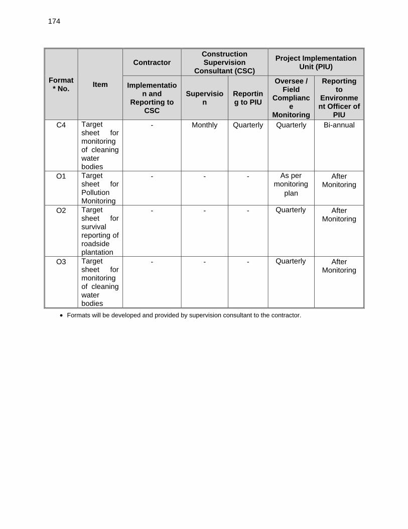
174
Format* No.
Item
Contractor Construction Supervision
Consultant (CSC)
Project Implementation Unit (PIU)
Implementation and
Reporting to CSC
Supervision
Reporting to PIU
Oversee / Field
Compliance
Monitoring
Reporting to
Environment Officer of
PIU C4 Target
sheet for monitoring of cleaning water bodies
- Monthly Quarterly Quarterly Bi-annual
O1 Target sheet for Pollution Monitoring
- - - As per monitoring
plan
After Monitoring
O2 Target sheet for survival reporting of roadside plantation
- - - Quarterly After Monitoring
O3 Target sheet for monitoring of cleaning water bodies
- - - Quarterly After Monitoring
Formats will be developed and provided by supervision consultant to the contractor.
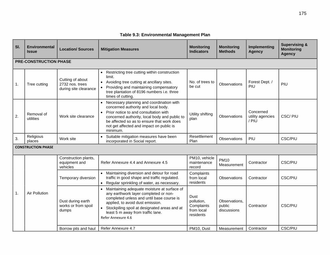
175
Table 9.3: Environmental Management Plan
Sl. Environmental Issue
Location/ Sources Mitigation Measures Monitoring Indicators
Monitoring Methods
Implementing Agency
Supervising & Monitoring Agency
PRE-CONSTRUCTION PHASE
1. Tree cutting Cutting of about 2732 nos. trees during site clearance
Restricting tree cutting within construction limit.
Avoiding tree cutting at ancillary sites. Providing and maintaining compensatory
tree plantation of 8196 numbers i.e. three times of cutting.
No. of trees to be cut
Observations Forest Dept. / PIU
PIU
2. Removal of utilities
Work site clearance
Necessary planning and coordination with concerned authority and local body.
Prior notice to and consultation with concerned authority, local body and public to be affected so as to ensure that work does not get affected and impact on public is minimum.
Utility shifting plan
Observations Concerned utility agencies / PIU
CSC/ PIU
3. Religious places
Work site Suitable mitigation measures have been incorporated in Social report.
Resettlement Plan
Observations PIU CSC/PIU
CONSTRUCTION PHASE
1. Air Pollution
Construction plants, equipment and vehicles
Refer Annexure 4.4 and Annexure 4.5 PM10, vehicle maintenance record
PM10 Measurement
Contractor CSC/PIU
Temporary diversion Maintaining diversion and detour for road
traffic in good shape and traffic regulated. Regular sprinkling of water, as necessary.
Complaints from local residents
Observations Contractor CSC/PIU
Dust during earth works or from spoil dumps
Maintaining adequate moisture at surface of any earthwork layer completed or non-completed unless and until base course is applied, to avoid dust emission.
Stockpiling spoil at designated areas and at least 5 m away from traffic lane.
Refer Annexure 4.6
Dust pollution, Complaints from local residents
Observations, public discussions
Contractor CSC/PIU
Borrow pits and haul Refer Annexure 4.7 PM10, Dust Measurement Contractor CSC/PIU
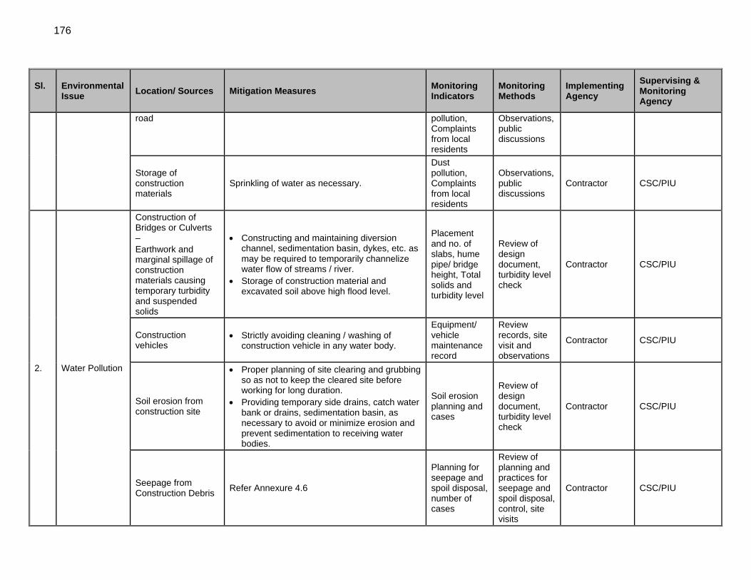
176
Sl. Environmental Issue
Location/ Sources Mitigation Measures Monitoring Indicators
Monitoring Methods
Implementing Agency
Supervising & Monitoring Agency
road pollution, Complaints from local residents
Observations, public discussions
Storage of construction materials
Sprinkling of water as necessary.
Dust pollution, Complaints from local residents
Observations, public discussions
Contractor CSC/PIU
2. Water Pollution
Construction of Bridges or Culverts – Earthwork and marginal spillage of construction materials causing temporary turbidity and suspended solids
Constructing and maintaining diversion channel, sedimentation basin, dykes, etc. as may be required to temporarily channelize water flow of streams / river.
Storage of construction material and excavated soil above high flood level.
Placement and no. of slabs, hume pipe/ bridge height, Total solids and turbidity level
Review of design document, turbidity level check
Contractor CSC/PIU
Construction vehicles
Strictly avoiding cleaning / washing of construction vehicle in any water body.
Equipment/ vehicle maintenance record
Review records, site visit and observations
Contractor CSC/PIU
Soil erosion from construction site
Proper planning of site clearing and grubbing so as not to keep the cleared site before working for long duration.
Providing temporary side drains, catch water bank or drains, sedimentation basin, as necessary to avoid or minimize erosion and prevent sedimentation to receiving water bodies.
Soil erosion planning and cases
Review of design document, turbidity level check
Contractor CSC/PIU
Seepage from Construction Debris
Refer Annexure 4.6
Planning for seepage and spoil disposal, number of cases
Review of planning and practices for seepage and spoil disposal, control, site visits
Contractor CSC/PIU
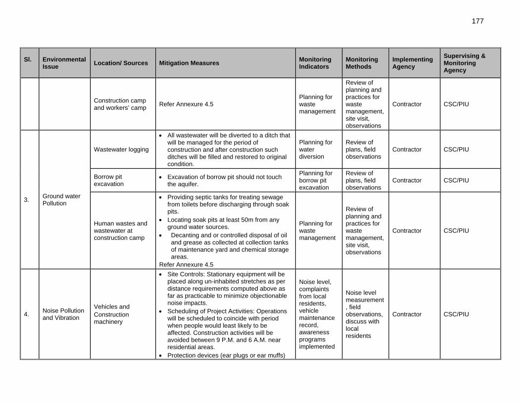
177
Sl. Environmental Issue
Location/ Sources Mitigation Measures Monitoring Indicators
Monitoring Methods
Implementing Agency
Supervising & Monitoring Agency
Construction camp and workers’ camp
Refer Annexure 4.5 Planning for waste management
Review of planning and practices for waste management, site visit, observations
Contractor CSC/PIU
3. Ground water Pollution
Wastewater logging
All wastewater will be diverted to a ditch that will be managed for the period of construction and after construction such ditches will be filled and restored to original condition.
Planning for water diversion
Review of plans, field observations
Contractor CSC/PIU
Borrow pit excavation
Excavation of borrow pit should not touch the aquifer.
Planning for borrow pit excavation
Review of plans, field observations
Contractor CSC/PIU
Human wastes and wastewater at construction camp
Providing septic tanks for treating sewage from toilets before discharging through soak pits.
Locating soak pits at least 50m from any ground water sources.
Decanting and or controlled disposal of oil and grease as collected at collection tanks of maintenance yard and chemical storage areas.
Refer Annexure 4.5
Planning for waste management
Review of planning and practices for waste management, site visit, observations
Contractor CSC/PIU
4. Noise Pollution and Vibration
Vehicles and Construction machinery
Site Controls: Stationary equipment will be placed along un-inhabited stretches as per distance requirements computed above as far as practicable to minimize objectionable noise impacts.
Scheduling of Project Activities: Operations will be scheduled to coincide with period when people would least likely to be affected. Construction activities will be avoided between 9 P.M. and 6 A.M. near residential areas.
Protection devices (ear plugs or ear muffs)
Noise level, complaints from local residents, vehicle maintenance record, awareness programs implemented
Noise level measurement, field observations, discuss with local residents
Contractor CSC/PIU
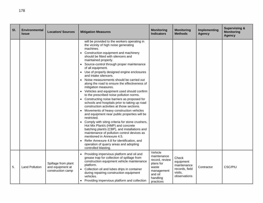
178
Sl. Environmental Issue
Location/ Sources Mitigation Measures Monitoring Indicators
Monitoring Methods
Implementing Agency
Supervising & Monitoring Agency
will be provided to the workers operating in the vicinity of high noise generating machines.
Construction equipment and machinery should be fitted with silencers and maintained properly.
Source-control through proper maintenance of all equipment.
Use of properly designed engine enclosures and intake silencers.
Noise measurements should be carried out along the road to ensure the effectiveness of mitigation measures.
Vehicles and equipment used should confirm to the prescribed noise pollution norms.
Constructing noise barriers as proposed for schools and hospitals prior to taking up road construction activities at those sections.
Movements of heavy construction vehicles and equipment near public properties will be restricted.
Comply with siting criteria for stone crushers, Hot Mix Plant/s (HMP) and concrete batching plant/s (CBP), and installations and maintenance of pollution control devices as mentioned in Annexure 4.5.
Refer Annexure 4.8 for identification, and operation of quarry areas and adopting controlled blasting.
5. Land Pollution Spillage from plant and equipment at construction camp
Providing impervious platform and oil and grease trap for collection of spillage from construction equipment vehicle maintenance platform.
Collection oil and lubes drips in container during repairing construction equipment vehicles.
Providing impervious platform and collection
Vehicle maintenance record, review plans for waste management and oil handling practices
Check equipment maintenance records, field visits, observations
Contractor CSC/PIU
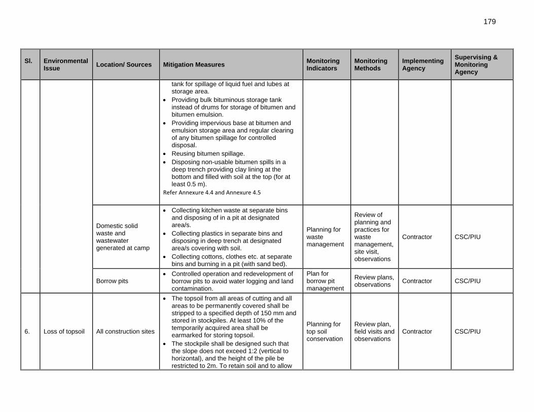
179
Sl. Environmental Issue
Location/ Sources Mitigation Measures Monitoring Indicators
Monitoring Methods
Implementing Agency
Supervising & Monitoring Agency
tank for spillage of liquid fuel and lubes at storage area.
Providing bulk bituminous storage tank instead of drums for storage of bitumen and bitumen emulsion.
Providing impervious base at bitumen and emulsion storage area and regular clearing of any bitumen spillage for controlled disposal.
Reusing bitumen spillage. Disposing non-usable bitumen spills in a
deep trench providing clay lining at the bottom and filled with soil at the top (for at least 0.5 m).
Refer Annexure 4.4 and Annexure 4.5
Domestic solid waste and wastewater generated at camp
Collecting kitchen waste at separate bins and disposing of in a pit at designated area/s.
Collecting plastics in separate bins and disposing in deep trench at designated area/s covering with soil.
Collecting cottons, clothes etc. at separate bins and burning in a pit (with sand bed).
Planning for waste management
Review of planning and practices for waste management, site visit, observations
Contractor CSC/PIU
Borrow pits Controlled operation and redevelopment of
borrow pits to avoid water logging and land contamination.
Plan for borrow pit management
Review plans, observations
Contractor CSC/PIU
6. Loss of topsoil All construction sites
The topsoil from all areas of cutting and all areas to be permanently covered shall be stripped to a specified depth of 150 mm and stored in stockpiles. At least 10% of the temporarily acquired area shall be earmarked for storing topsoil.
The stockpile shall be designed such that the slope does not exceed 1:2 (vertical to horizontal), and the height of the pile be restricted to 2m. To retain soil and to allow
Planning for top soil conservation
Review plan, field visits and observations
Contractor CSC/PIU
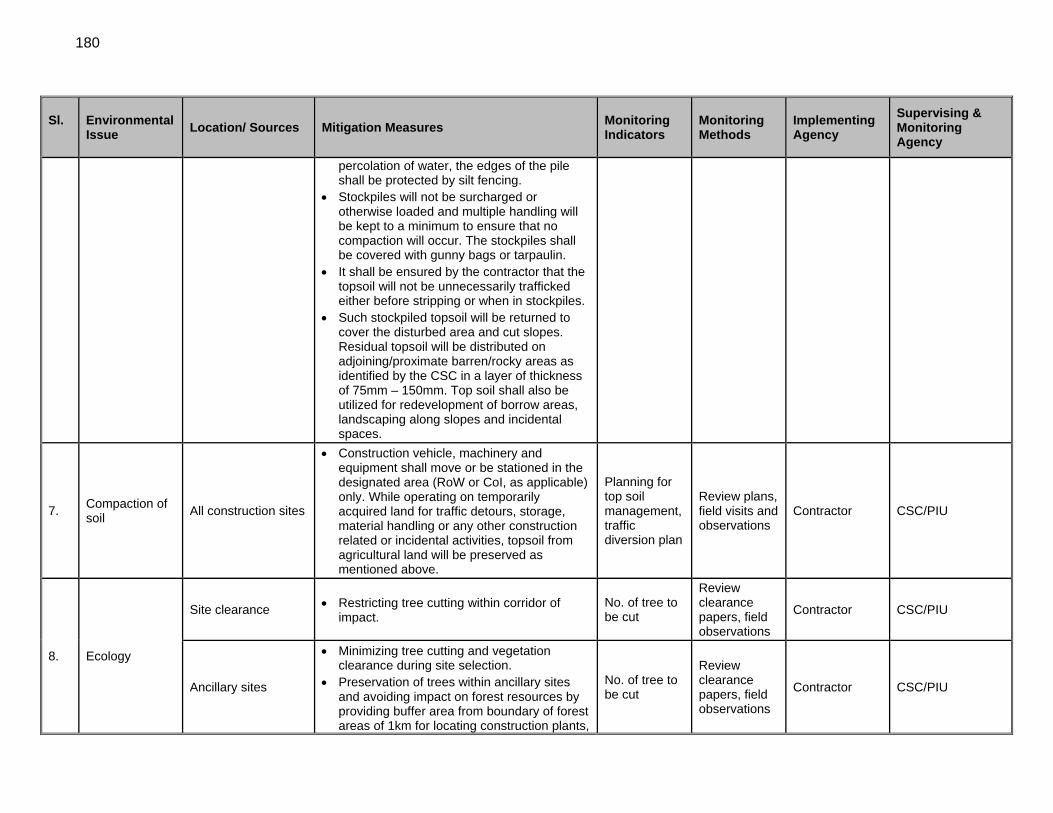
180
Sl. Environmental Issue
Location/ Sources Mitigation Measures Monitoring Indicators
Monitoring Methods
Implementing Agency
Supervising & Monitoring Agency
percolation of water, the edges of the pile shall be protected by silt fencing.
Stockpiles will not be surcharged or otherwise loaded and multiple handling will be kept to a minimum to ensure that no compaction will occur. The stockpiles shall be covered with gunny bags or tarpaulin.
It shall be ensured by the contractor that the topsoil will not be unnecessarily trafficked either before stripping or when in stockpiles.
Such stockpiled topsoil will be returned to cover the disturbed area and cut slopes. Residual topsoil will be distributed on adjoining/proximate barren/rocky areas as identified by the CSC in a layer of thickness of 75mm – 150mm. Top soil shall also be utilized for redevelopment of borrow areas, landscaping along slopes and incidental spaces.
7. Compaction of soil
All construction sites
Construction vehicle, machinery and equipment shall move or be stationed in the designated area (RoW or CoI, as applicable) only. While operating on temporarily acquired land for traffic detours, storage, material handling or any other construction related or incidental activities, topsoil from agricultural land will be preserved as mentioned above.
Planning for top soil management, traffic diversion plan
Review plans, field visits and observations
Contractor CSC/PIU
8. Ecology
Site clearance Restricting tree cutting within corridor of impact.
No. of tree to be cut
Review clearance papers, field observations
Contractor CSC/PIU
Ancillary sites
Minimizing tree cutting and vegetation clearance during site selection.
Preservation of trees within ancillary sites and avoiding impact on forest resources by providing buffer area from boundary of forest areas of 1km for locating construction plants,
No. of tree to be cut
Review clearance papers, field observations
Contractor CSC/PIU
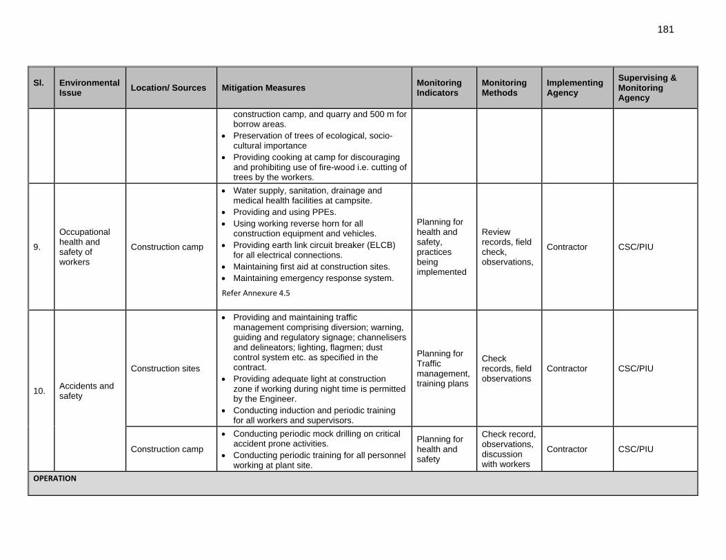
181
Sl. Environmental Issue
Location/ Sources Mitigation Measures Monitoring Indicators
Monitoring Methods
Implementing Agency
Supervising & Monitoring Agency
construction camp, and quarry and 500 m for borrow areas.
Preservation of trees of ecological, socio-cultural importance
Providing cooking at camp for discouraging and prohibiting use of fire-wood i.e. cutting of trees by the workers.
9.
Occupational health and safety of workers
Construction camp
Water supply, sanitation, drainage and medical health facilities at campsite.
Providing and using PPEs. Using working reverse horn for all
construction equipment and vehicles. Providing earth link circuit breaker (ELCB)
for all electrical connections. Maintaining first aid at construction sites. Maintaining emergency response system.
Refer Annexure 4.5
Planning for health and safety, practices being implemented
Review records, field check, observations,
Contractor CSC/PIU
10. Accidents and safety
Construction sites
Providing and maintaining traffic management comprising diversion; warning, guiding and regulatory signage; channelisers and delineators; lighting, flagmen; dust control system etc. as specified in the contract.
Providing adequate light at construction zone if working during night time is permitted by the Engineer.
Conducting induction and periodic training for all workers and supervisors.
Planning for Traffic management, training plans
Check records, field observations
Contractor CSC/PIU
Construction camp
Conducting periodic mock drilling on critical accident prone activities.
Conducting periodic training for all personnel working at plant site.
Planning for health and safety
Check record, observations, discussion with workers
Contractor CSC/PIU
OPERATION
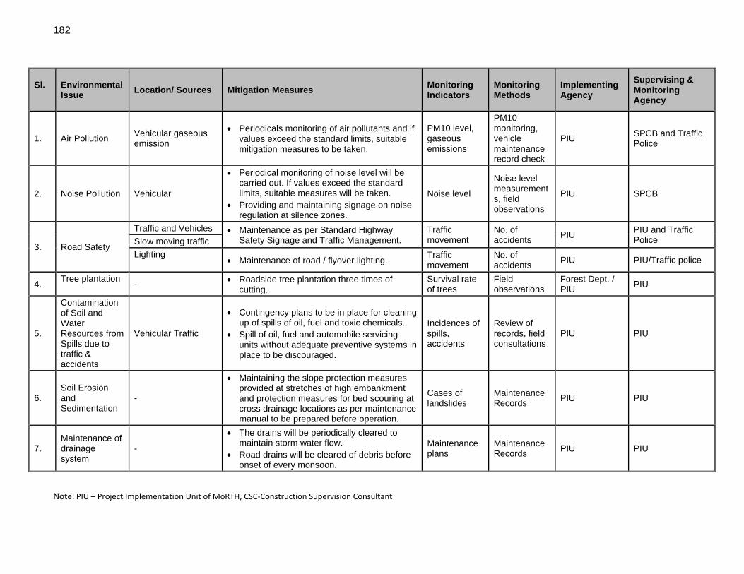
182
Sl. Environmental Issue
Location/ Sources Mitigation Measures Monitoring Indicators
Monitoring Methods
Implementing Agency
Supervising & Monitoring Agency
1. Air Pollution Vehicular gaseous emission
Periodicals monitoring of air pollutants and if values exceed the standard limits, suitable mitigation measures to be taken.
PM10 level, gaseous emissions
PM10 monitoring, vehicle maintenance record check
PIU SPCB and Traffic Police
2. Noise Pollution Vehicular
Periodical monitoring of noise level will be carried out. If values exceed the standard limits, suitable measures will be taken.
Providing and maintaining signage on noise regulation at silence zones.
Noise level
Noise level measurements, field observations
PIU SPCB
3. Road Safety
Traffic and Vehicles Maintenance as per Standard Highway Safety Signage and Traffic Management.
Traffic movement
No. of accidents
PIU PIU and Traffic Police Slow moving traffic
Lighting
Maintenance of road / flyover lighting. Traffic movement
No. of accidents
PIU PIU/Traffic police
4. Tree plantation
- Roadside tree plantation three times of cutting.
Survival rate of trees
Field observations
Forest Dept. / PIU
PIU
5.
Contamination of Soil and Water Resources from Spills due to traffic & accidents
Vehicular Traffic
Contingency plans to be in place for cleaning up of spills of oil, fuel and toxic chemicals.
Spill of oil, fuel and automobile servicing units without adequate preventive systems in place to be discouraged.
Incidences of spills, accidents
Review of records, field consultations
PIU PIU
6. Soil Erosion and Sedimentation
-
Maintaining the slope protection measures provided at stretches of high embankment and protection measures for bed scouring at cross drainage locations as per maintenance manual to be prepared before operation.
Cases of landslides
Maintenance Records
PIU PIU
7. Maintenance of drainage system
-
The drains will be periodically cleared to maintain storm water flow.
Road drains will be cleared of debris before onset of every monsoon.
Maintenance plans
Maintenance Records
PIU PIU
Note: PIU – Project Implementation Unit of MoRTH, CSC‐Construction Supervision Consultant
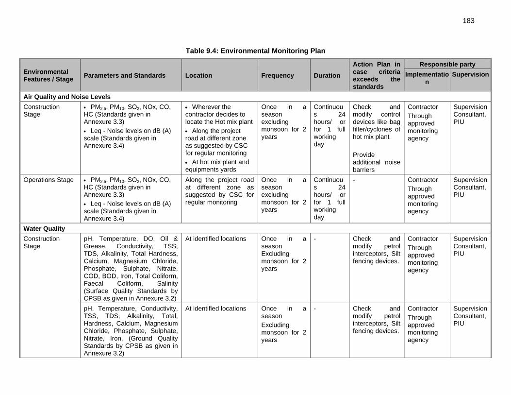
183
Table 9.4: Environmental Monitoring Plan
Environmental Features / Stage
Parameters and Standards Location Frequency Duration
Action Plan in case criteria exceeds the standards
Responsible party
Implementation
Supervision
Air Quality and Noise Levels
Construction Stage
PM2.5, PM10, SO2, NOx, CO, HC (Standards given in Annexure 3.3) Leq - Noise levels on dB (A) scale (Standards given in Annexure 3.4)
Wherever the contractor decides to locate the Hot mix plant Along the project road at different zone as suggested by CSC for regular monitoring At hot mix plant and equipments yards
Once in a season excluding monsoon for 2 years
Continuous 24 hours/ or for 1 full working day
Check and modify control devices like bag filter/cyclones of hot mix plant Provide additional noise barriers
Contractor Through approved monitoring agency
Supervision Consultant, PIU
Operations Stage PM2.5, PM10, SO2, NOx, CO, HC (Standards given in Annexure 3.3) Leq - Noise levels on dB (A) scale (Standards given in Annexure 3.4)
Along the project road at different zone as suggested by CSC for regular monitoring
Once in a season excluding monsoon for 2 years
Continuous 24 hours/ or for 1 full working day
- Contractor Through approved monitoring agency
Supervision Consultant, PIU
Water Quality
Construction Stage
pH, Temperature, DO, Oil & Grease, Conductivity, TSS, TDS, Alkalinity, Total Hardness, Calcium, Magnesium Chloride, Phosphate, Sulphate, Nitrate, COD, BOD, Iron, Total Coliform, Faecal Coliform, Salinity (Surface Quality Standards by CPSB as given in Annexure 3.2)
At identified locations Once in a season Excluding monsoon for 2 years
- Check and modify petrol interceptors, Silt fencing devices.
Contractor Through approved monitoring agency
Supervision Consultant, PIU
pH, Temperature, Conductivity, TSS, TDS, Alkalinity, Total, Hardness, Calcium, Magnesium Chloride, Phosphate, Sulphate, Nitrate, Iron. (Ground Quality Standards by CPSB as given in Annexure 3.2)
At identified locations Once in a season Excluding monsoon for 2 years
- Check and modify petrol interceptors, Silt fencing devices.
Contractor Through approved monitoring agency
Supervision Consultant, PIU
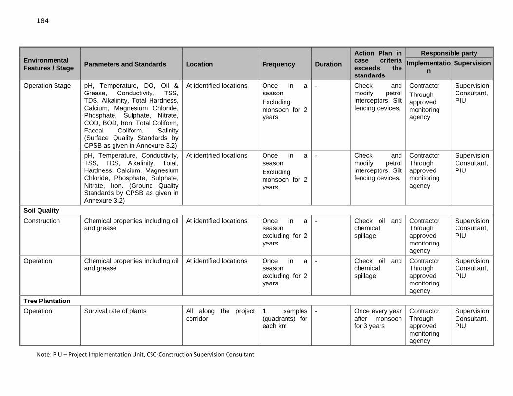
184
Environmental Features / Stage
Parameters and Standards Location Frequency Duration
Action Plan in case criteria exceeds the standards
Responsible party
Implementation
Supervision
Operation Stage pH, Temperature, DO, Oil & Grease, Conductivity, TSS, TDS, Alkalinity, Total Hardness, Calcium, Magnesium Chloride, Phosphate, Sulphate, Nitrate, COD, BOD, Iron, Total Coliform, Faecal Coliform, Salinity (Surface Quality Standards by CPSB as given in Annexure 3.2)
At identified locations Once in a season Excluding monsoon for 2 years
- Check and modify petrol interceptors, Silt fencing devices.
Contractor Through approved monitoring agency
Supervision Consultant, PIU
pH, Temperature, Conductivity, TSS, TDS, Alkalinity, Total, Hardness, Calcium, Magnesium Chloride, Phosphate, Sulphate, Nitrate, Iron. (Ground Quality Standards by CPSB as given in Annexure 3.2)
At identified locations Once in a season Excluding monsoon for 2 years
- Check and modify petrol interceptors, Silt fencing devices.
Contractor Through approved monitoring agency
Supervision Consultant, PIU
Soil Quality
Construction Chemical properties including oil and grease
At identified locations Once in a season excluding for 2 years
- Check oil and chemical spillage
Contractor Through approved monitoring agency
Supervision Consultant, PIU
Operation Chemical properties including oil and grease
At identified locations Once in a season excluding for 2 years
- Check oil and chemical spillage
Contractor Through approved monitoring agency
Supervision Consultant, PIU
Tree Plantation
Operation Survival rate of plants All along the project corridor
1 samples (quadrants) for each km
- Once every year after monsoon for 3 years
Contractor Through approved monitoring agency
Supervision Consultant, PIU
Note: PIU – Project Implementation Unit, CSC‐Construction Supervision Consultant
185
F. Institutional Requirements
438. The Public Works Department of Manipur (MPWD) will be the executing agency (EA) as well as Implementing Agency (IA) for this subproject. The project will be implemented by PIU of MPWD based on Imphal. EA/IA will be responsible for the implementation of the Project. The Project Director of PIU will be overall responsible for EMP implementation. The following key players are involved in EMP implementation during construction stage:
EA and its Implementation Support Consultants (ISC) PIU and its environmental units; Construction Supervision Consultants (CSC) i.e. Engineer and his representatives;
and Contractors.
439. The PIU will have an Environmental and Social Management Unit (EMSU). It is recommended that one of the senior officers of PIU could be designated as Environmental and Social Officer for monitoring implementation of proposed safeguard measures. EMSU will be headed by the Project Director but coordinating and supervising implementation of safeguard measures will be undertaken by the designated Environmental and Social Officer. There is a need for capacity building of environmental unit through various trainings. 440. The Project Director of PIU with the assistance of designated Environmental and Social Officer will be overall responsible for ensuring compliance of safeguard measures and will be reporting to the regulatory bodies and ADB certifying that relevant environmental safeguard measures have been complied with during project implementation. At the field level, the Executive Engineer with his Assistant Engineer/s will supervise implementation of safeguard measures for this subproject and submit monthly reports to PIU. 441. PIU may engage independent agencies for carrying out pollution monitoring activities. The Supervision Consultant shall be interacting with these agencies and facilitate them in carrying out such activities. 442. The Construction Supervision Consultant (CSC) will have an Environmental Safeguards Specialist in its team and it will liaise with PIU environment unit to ensure that Contractor complies with the requirements of various environmental safeguard measures through supervision, monitoring and reporting on the same. Efforts must be made by SC to ensure that environmental mitigation and good-construction-practices are not only considered but actually implemented as integral component of each civil activity. It should be considered as day-to-day activity. Implementation of environmental safeguard measures needs team effort and as such the Team Leader of CSC will delegate the responsibilities to each member of the supervision team with respect to their core responsibilities. The project should have a provision of Environmental Specialist within CSC to supervise implementation of safeguard measures. His role would be more on advisory. He will assist the Team Leader of CSC on the following:
Advise PIU on preparing reports to ADB and other statutory bodies; Preparing procedures for implementing EMP; review Contractor’s EMP, traffic management plan and safety plan and recommend
for its approval / improvements, to the Team Leader; provide training to PIU, CSC and Contractors’ staff on implementing environmental
safeguard measures;
186
advise on obtaining various statutory environmental clearances on time; conduct periodic field visits to examine environmental compliances and suggest
corrective actions ; and any other issues as will be required to ensure environmental compliance.
443. Besides, the Team Leader of CSC will nominate a senior engineer from the site office for being directly responsible for day-to-day supervision of implementation of stipulated safeguard measures, to ensure accountability. He will provide guidance to the field staff of SC and Contractor for implementing each of the activities as per the EMP. He will be responsible for record keeping, providing instructions through the Engineer for corrective actions, ensuring compliance of various statutory and legislative requirements and assist Engineer for submitting reports to PIU. He will maintain a close co-ordination with the Contractor and PIU for successful implementation of the environmental safeguard measures. 444. Responsibilities of various agencies involved in the project implementation are described in following paragraphs.
1. Executing Agencies (EAs) Responsibilities
445. The EA’s responsibilities will mainly be focussed on addressing national or state level environment safeguard issues and decisions concerning the subprojects. Specific responsibilities on environment safeguards at the EA level are:
Ensure that all environment safeguard requirements as given in ADB SPS 2009, and applicable laws and rules under MOEF are being complied with during all stages of respective subprojects under the loan.
Reviewing and approving all environment safeguards related documents such as EIA or IEE, monitoring reports etc. prepared for subprojects under the investment program with recommendations and clarifications from the IA where necessary.
Timely endorsement and signing of key documents and forwarding to the respective agency such as those required for processing of environmental clearance, forestry clearance etc. and disclosure on ADB website.
Taking proactive and timely measures to address any environment safeguards related challenges at the national or state level such as delays in processing of clearances (during pre-construction stage), significant grievances (during construction stage)
Recruiting an external monitor to conduct third party environmental monitoring for category A and B subprojects
2. Implementing Agencies (IAs) Responsibilities
446. The IA’s responsibilities will mainly be focussed on implementing environment safeguard requirements in accordance with the EIA or IEE and EMP at the subproject and site level. Specific responsibilities on environment safeguards at the IA level are:
Where necessary hire an environmental consultant to prepare IEE or EIA report including EMP as may be required.
Ensure that the consultant follows all procedures for conducting the environmental assessment as given in ADB’s SPS.
187
Review the budgetary needs for complying with the Government’s and ADB’s requirements on environment safeguards and ensure the proposed budget is in line with project requirements.
Prepare forms, reports and all documents etc. for processing of environmental, forestry and related clearances in a timely manner and submit them for further review and signing to the authorized officer in the respective EA office.
If any problems or long delays are encountered when processing the clearance documents, immediately alert the authorized officer at the EA level and seek ways resolve the problem at the soonest.
Provide necessary support to the consultants preparing the environmental assessment reports to facilitate smooth and efficient preparation of documents, conduction of meetings, conduction of public hearings etc. required by ADB, MOEF, SPCB, Forestry Department, Wildlife Board etc.
Review the EIA or IEE reports including EMP and EMOP prepared by the consultant and provide comments if necessary.
After receipt of satisfactory EIA or IEE report including EMP and EMOP forward the respective reports to the respective EA for further endorsement and forwarding to ADB for disclosure on the ADB website.
Ensure that all necessary regulatory clearances are obtained prior to commencing any civil work of the respective contract package or road section.
Ensure that for Engineering Procurement and Construction (EPC) based contracts updating of the EMP and EMOP based on detailed design and implementation of the EMP is included under the contractor’s responsibilities.
Ensure that the EMP which includes required mitigation measures and monitoring requirements with defined Bill of Quantity (BOQ), forms part of bidding document for the case of item rate based contracts.
Ensure that contractors have access to the EIA or IEE report including EMP and EMOP of the subprojects.
Ensure that contractors understand their responsibilities to mitigate environmental problems associated with their construction activities.
Ensure and Monitor that all required permits, no objection certificates etc. are obtained by the contractor for establishment and operation of equipments and facilities as detailed in EIA/IEE.
With the support of the EFP of the contractors and ISC ensure that the contractor implements the EMP including EMOP as given in the respective EIA or IEE report.
In case of unanticipated environmental impacts during project implementation stage, with the support of ISC prepare and implement an updated EMP to account for such impacts after seeking concurrence from ADB. The updating shall be carried out after due consultation with the stake holders and concerned government agencies.
In case during project implementation a subproject needs to be realigned, review the environmental classification and revise accordingly, and identify whether supplementary IEE or EIA study is required. If it is required, prepare the TOR for undertaking supplementary IEE or EIA and hire an environment consultant to carry out the study.
Ensure that construction workers work under safe and healthy working environment. Ensure effective implementation of Grievance Redress Mechanism to address
affected people’s concerns and complaints. Submit semi-annual reports for category A subprojects and annual reports for
category B subprojects on the implementation of all environment safeguard
188
requirements including the EMP and EMOP under the respective subproject to ADB and make these reports available for public disclosure.
3. ADB’s Responsibilities
447. ADB is responsible for the following:
Review REA checklist and endorse or modify the tranche classification proposed by the EA
Review EIA or IEE reports and disclose the draft and final reports on the ADB website as required;
Issue subproject’s approval based on EIA or IEE reports; Monitor implementation of the EMP through due diligence missions; Provide assistance to the EA and IA of subprojects, if required, in carrying out its
responsibilities and for building capacity for safeguard compliance; Monitor overall compliance of the subprojects to this EARF; and If necessary provide further guidance to the IA on the format, content, and scope �of
the EIA or IEE reports and annual and/or semi-annual monitoring reports for submission to ADB.
448. For ensuring that EMP is properly implemented, Contractor shall appoint a full time qualified and experienced Environmental and Safety Officer (ESO) from the commencement to completion of the project. The qualification and responsibilities of ESO as stipulated below should be considered. The qualification of ESO will be as given below:
Diploma or Graduate in Civil Engineering with post graduate specialization in Environmental Engineering or Environmental Science or equivalent;
5 to 10 years of total professional experience; and About 3 to 5 years of experience in similar projects i.e. management of
environmental issues in design and construction of road / highway / flyover / bridge projects.
449. The responsibilities of ESO of Contractor will include the following:
Directly reporting to the Project Manager of the Contractor; Discussing various environmental issues and environmental mitigation,
enhancement and monitoring actions with all concerned directly or indirectly; Prepare Contractor’s EMP, traffic management plan and safety plan as part of their
Work Program; Ensure contractor’s compliance with the EMP stipulations and conditions of statutory
bodies; Assisting his project manager to ensure environmentally sound and safe construction
practices; Assisting his project manager to ensure the timely procurement of materials that are
included in the Bill of Quantities relating to environmental mitigation and enhancement measures;
Conducting periodic environmental and safety training for contractor’s engineers, supervisors and workers;
Preparing a registers for material sources, labour, pollution monitoring results, public complaint and as may be directed by the Engineer;
189
Assisting the PIU on various environmental monitoring and control activities including pollution monitoring; and
Preparing and submitting monthly reports to SC on status of implementation safeguard measures.
450. As mentioned above, there will need for capacity building of PIU on various environmental and social aspects of the project through various environmental training. Recently, there has been change of statutory requirements for this similar projects based on new EIA Notification. This has changed the landscape of legal and administrative framework for implementing the projects. Thus, there is a need for the PIU staff to updating the information and keeping abreast with the changing legal and administrative requirement. The requirements of various statutory permits and clearances are mentioned in Table 4.3 (Chapter 4). For successful implementation of EMP, it is essential to orient engineers of PIU, CSC and Contractor who would be mobilized for this project. One day environmental orientation workshop will be conducted at Imphal by ADB supported consultant, once most of the staff has been mobilized. The training program is included in Annexure 10.1. G. Environmental Management Budget
451. An environmental management budget of INR 3,453,075 (Indian Rupees Three million sixty three one thousand and seventy five only) (US$ 0.57 milion) has been estimated for implementation of the environmental management plan. This budget also includes cost of environmental monitoring and associated trainings. A detail of environmental management budget is given in Table 9.6.
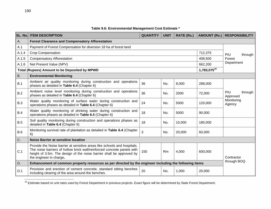
190
Table 9.6: Environmental Management Cost Estimate *
SL. No. ITEM DESCRIPTION QUANTITY UNIT RATE (Rs.) AMOUNT (Rs.) RESPONSIBILITY
A. Forest Clearance and Compensatory Afforestation
A.1 Payment of Forest Compensation for diversion 18 ha of forest land
PIU through Forest Department
A.1.4 Crop Compensation 712,375
A.1.5 Compensatory Afforestation 408,500
A.1.6 Net Present Value (NPV) 662,200
Total (Rupees) Amount to be Deposited by MPWD 1,783,07516
B. Environmental Monitoring
B.1 Ambient air quality monitoring during construction and operations phases as detailed in Table 6.4 (Chapter 6)
36 No. 8,000 288,000
PIU through Approved Monitoring Agency
B.2 Ambient noise level monitoring during construction and operations phases as detailed in Table 6.4 (Chapter 6)
36 No. 2000 72,000
B.3 Water quality monitoring of surface water during construction and operations phases as detailed in Table 6.4 (Chapter 6)
24 No. 5000 120,000
B.4 Water quality monitoring of drinking water during construction and operations phases as detailed in Table 6.4 (Chapter 6)
18 No. 5000 90,000
B.5 Soil quality monitoring during construction and operations phases as detailed in Table 6.4 (Chapter 6)
18 No. 10,000 180,000
B.6 Monitoring survival rate of plantation as detailed in Table 6.4 (Chapter 6)
3 No. 20,000 60,000
C. Noise Barrier at sensitive location
C.1
Provide the Noise barrier at sensitive areas like schools and hospitals. The noise barriers of hollow brick wall/reinforced concrete panels with height of 3.5m. The design of the noise barrier shall be approved by the engineer in charge.
150 Rm 4,000 600,000
Contractor through BOQ
D. Enhancement of common property resources as per directed by the engineer including the following items
D.1 Provision and erection of cement concrete, standard sitting benches including clearing of the area around the benches.
20 No. 1,000 20,000
16 Estimate based on unit rates used by Forest Department in previous projects. Exact figure will be determined by State Forest Department.
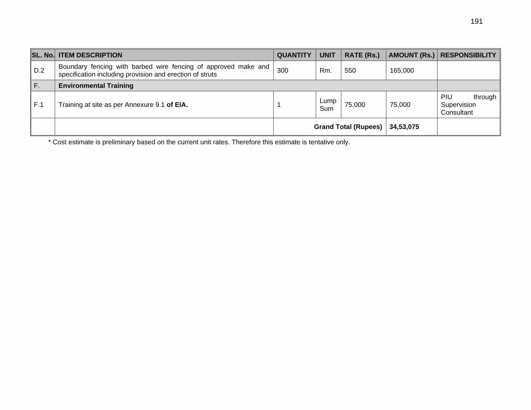
191
SL. No. ITEM DESCRIPTION QUANTITY UNIT RATE (Rs.) AMOUNT (Rs.) RESPONSIBILITY
D.2 Boundary fencing with barbed wire fencing of approved make and specification including provision and erection of struts
300 Rm. 550 165,000
F. Environmental Training
F.1 Training at site as per Annexure 9.1 of EIA. 1 Lump Sum
75,000 75,000 PIU through Supervision Consultant
Grand Total (Rupees) 34,53,075
* Cost estimate is preliminary based on the current unit rates. Therefore this estimate is tentative only.
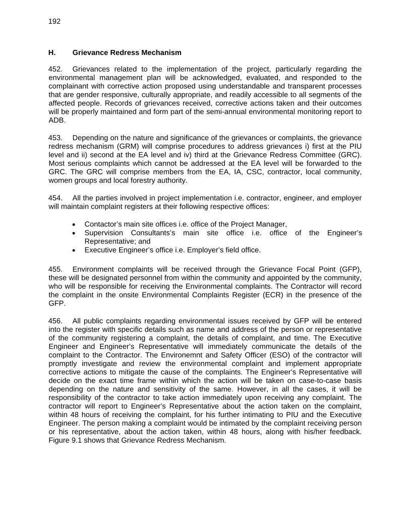
192
H. Grievance Redress Mechanism
452. Grievances related to the implementation of the project, particularly regarding the environmental management plan will be acknowledged, evaluated, and responded to the complainant with corrective action proposed using understandable and transparent processes that are gender responsive, culturally appropriate, and readily accessible to all segments of the affected people. Records of grievances received, corrective actions taken and their outcomes will be properly maintained and form part of the semi-annual environmental monitoring report to ADB. 453. Depending on the nature and significance of the grievances or complaints, the grievance redress mechanism (GRM) will comprise procedures to address grievances i) first at the PIU level and ii) second at the EA level and iv) third at the Grievance Redress Committee (GRC). Most serious complaints which cannot be addressed at the EA level will be forwarded to the GRC. The GRC will comprise members from the EA, IA, CSC, contractor, local community, women groups and local forestry authority. 454. All the parties involved in project implementation i.e. contractor, engineer, and employer will maintain complaint registers at their following respective offices:
Contactor’s main site offices i.e. office of the Project Manager, Supervision Consultants’s main site office i.e. office of the Engineer’s
Representative; and Executive Engineer’s office i.e. Employer’s field office.
455. Environment complaints will be received through the Grievance Focal Point (GFP), these will be designated personnel from within the community and appointed by the community, who will be responsible for receiving the Environmental complaints. The Contractor will record the complaint in the onsite Environmental Complaints Register (ECR) in the presence of the GFP. 456. All public complaints regarding environmental issues received by GFP will be entered into the register with specific details such as name and address of the person or representative of the community registering a complaint, the details of complaint, and time. The Executive Engineer and Engineer’s Representative will immediately communicate the details of the complaint to the Contractor. The Environemnt and Safety Officer (ESO) of the contractor will promptly investigate and review the environmental complaint and implement appropriate corrective actions to mitigate the cause of the complaints. The Engineer’s Representative will decide on the exact time frame within which the action will be taken on case-to-case basis depending on the nature and sensitivity of the same. However, in all the cases, it will be responsibility of the contractor to take action immediately upon receiving any complaint. The contractor will report to Engineer’s Representative about the action taken on the complaint, within 48 hours of receiving the complaint, for his further intimating to PIU and the Executive Engineer. The person making a complaint would be intimated by the complaint receiving person or his representative, about the action taken, within 48 hours, along with his/her feedback. Figure 9.1 shows that Grievance Redress Mechanism.
193
Figure 9.1: Grievance Redress Mechanism
Affected Person through GFP
Contractor
Not Redressed
Resolve through Local Legal Process
Redressed (2 days)
Appeal to Grievance Redress Committee dressed (15 days)
Not Redressed
Resolve with PIU (SC) Consultant Redressed (7 days)
Not Redressed
Resolve with EA dressed (15 days)
Not Redressed
194
X. CONCLUSIONS AND RECOMMENDATIONS
457. The proposed Imphal-Kanchup-Tamenglong subproject proposed for improvement is classified as environment Category A projects as per ADB SPS requirements, since the subproject involves construction of new road for about 97 kms. As per Government of India regulations EC is required for this subproject since the project road is located above 1000 m above mean seal level. Forest Clearance for Central/State Government is also required since the project will require acquisition of about 18 hectares of forest land. The categorization has been done based on environmental screening and assessment of likely impacts while the environmental impact assessment ascertains that it is unlikely to cause any significant environmental impacts. Few impacts were identified attributable to the proposed project, all of which are localized and temporary in nature and easy to mitigate. 458. About 6 km length of subproject roads passes through Kanchup reserve forest. There are no other ecologically sensitive areas along the subproject road neither there are any archaeological/protected monument located in the project vicinity. Except for initial 15 km section (from imphal-Kanchup), the proposed alignment passes through hilly terrain. The land use pattern around the proposed alignment is predominantly mix of forest and agriculture land. 459. The significant adverse impacts of the road section upgrading are:
Impacts from acquisition of about 291 hectares of land for construction of new road between Kanchup and Tamenglong.
Impacts on surrounding area due to tree cutting (2732) for the proposed widening; Potential impacts on endangered species existing in the project area Impacts due to conversion of about 18 hectare of forest land for non-forest purpose; Temporary impact on land and air environment due to locating construction camp; Temporary impact on land, air and water environment due to establishing and
operating construction plants (Hot Mix Plant and Diesel Generator [DG] sets); Impacts on roadside flora and fauna particularly on sections of road passing through
forest area; Impact on air quality, water quality, drainage, road users due to construction
activities of project road; Impact on land and water environment due to disposal of waste materials; and Impact on occupational health and safety due to all on-site and off-site construction
works. 460. Measures such as use of EFRC slope protection measures are proposed to minimize the impacts of slope instability, use of bioengineering technique, compensatory afforestation, measures to minimize impacts on wildlife movement, engineering alternatives to limit impacts on forest areas etc. are proposed to minimize the potential impacts. 461. Besides, series of mitigation measures have been proposed that are described in the EIA Report and addressed comprehensively in the environmental management plan. These include provision of bioengineering applications for stabilizing slopes, use of spoil disposal areas to minimize destruction of forests down-slope of the alignment, proper sizing of hydraulic structures to assure adequate capacity and prevent destruction of adjacent land, provision of sign boards along migratory paths of animals and other precious ecological zones, provision of bridges and culverts designed especially for facilitating the movement of animals, identification of vulnerable community infrastructure that must be preserved or replaced under construction
195
contracts, limits on location and access of workers and other provisions regarding construction to assure minimum impact, and other basic provisions found in the EMP. All the above observations and mitigation measures will be included in the tender documents for contract works. 462. Application of these measures in parallel with MoRTH environmentally friendly road construction practices will reduce significantly any potential environmental impact. Impacts remaining on the physical environment (air and water pollution) are temporary and often occur away from the presence of people. The biological environment will reconstitute itself following any residual or remaining impacts on it. 463. Potential adverse effects during operations of the roadways have been minimized by aligning the road in optimal locations in relation to roadway safety and community impact, through provision of designs and budgets for superior roadway drainage structures. 464. A systematic approach for surveillance and monitoring is provided by means of a management framework, and monitoring and reporting protocol. In general, the project received good support from local people. The local people appreciated that besides providing an all-weather efficient connectivity to large rural populations and improving the traffic scenario in the region, it will bear out several other socio-economic positive benefits. Follow-up public consultation is intended to provide future input to the identification of environmental impact during the construction phase as well as a grievance redress mechanism for project affected persons. The social component of the project has identified the numbers of affected persons and households, the amount and locations requiring total and partial land acquisition, and the amount of damage costs. The EMP is a living document and the same will be revised if necessary during project implementation or if there is any change in the project design and with approval of ADB during the construction period. The environmental mitigation measures are itemized in the EMP and the EA and IA shall ensure that EMP and EMoP are included in Bill of Quantity (BOQ) and forms part of bid document and civil works contract. 465. Before the start of civil works for the any section of the project road the project proponent (PWD Manipur) must obtain necessary clearances / permits from staturoty authorities.