IND: India Infrastructure Project Financing Facility II ... · 6-Laning of Chilakaluripet to...
227
Environment and Social Due Diligence Report July 2012 IND: India Infrastructure Project Financing Facility II –Simhapuri Expressway Ltd. Prepared by India Infrastructure Finance Company Limited This report has been submitted to ADB by the India Infrastructure Finance Company Limited (IIFCL) and is made publicly available in accordance with ADB’s public communications policy (2005). It does not necessarily reflect the views of ADB.
-
Upload
nguyentuyen -
Category
Documents
-
view
224 -
download
0
Transcript of IND: India Infrastructure Project Financing Facility II ... · 6-Laning of Chilakaluripet to...

Environment and Social Due Diligence Report July 2012
IND: India Infrastructure Project Financing Facility II –Simhapuri Expressway Ltd. Prepared by India Infrastructure Finance Company Limited This report has been submitted to ADB by the India Infrastructure Finance Company Limited (IIFCL) and is made publicly available in accordance with ADB’s public communications policy (2005). It does not necessarily reflect the views of ADB.

Environment and Social Due Diligence Report Simhapuri Expressway Limited
1
INDIA INFRASTRUCTURE FINANCE COMPANY LTD.
Simhapuri Expressway Ltd. (SEL) 6-Laning of Chilakaluripet to Nellore section of National Highway No.5 from Km
1182.802 to Km. 1366.547 (Including 10.125 km long New Ongole bypass) in the State of Andhra Pradesh on DBFOT pattern
June, 2012
Environment and Social Due Diligence Report Simhapuri Expressway Limited
2
CONTENTS
1. INTRODUCTION ......................................................................................................... 5 2. CONCESSIONAIRE: ................................................................................................... 8 3. INDEPENDENT CONSULTANT: ................................................................................. 9 4. EPC CONTRACTORS:................................................................................................ 9 5. LENDER’S ENGINEER: .............................................................................................. 9 DUE DILIGENCE ON ENVIRONMENTAL SAFEGUARDS: .................................................... 10 6. AVAILABILITY OF EIA/EMP REPORTS: ................................................................. 11 7. ENVIRONMENTAL SENSITIVITY AND DUE DILIGENCE: ....................................... 11 8. CATEGORIZATION OF SUB-PROJECT: ................................................................. 13 9. STATUS OF REGULATORY CLEARANCES: .......................................................... 13 10. PUBLIC CONSULTATION AND INFORMATION DISCLOSURE: ............................ 16 11. ALTERNATIVE ANALYSIS: ...................................................................................... 17 12. ENVIRONMENT AND SAFETY CLAUSES IN CONCESSION AGREEMENT: ......... 18 13. ENVIRONMENT AND SAFETY CLAUSES IN EPC CONTRACT: ............................ 19 14. EMP IMPLEMENTATION BUDGET: ......................................................................... 20 15. ENVIRONMENT MANAGEMENT PLAN (EMP) IMPLEMENTATION: ...................... 20 15.1. CONCESSIONAIRE AND EPC CONTRACTOR’S HSE PLAN: .............................................. 20 15.2. EMP COMPLIANCE STATUS:.................................................................................................. 21 15.3. ENVIRONMENTAL MONITORING: .......................................................................................... 21 15.4. INSTITUTIONAL FRAMEWORK FOR EMP IMPLEMENTATION: .......................................... 21 16. SITE VISIT OBSERVATIONS: .................................................................................. 24 17. CONCLUSIONS AND RECOMMENDATION: ........................................................... 25 DUE DILIGENCE ON SOCIAL SAFEGUARDS ....................................................................... 27 18. SOCIAL SAFEGUARDS DUE DILIGENCE REPORT: .............................................. 28 18.1. METHODOLOGY ADOPTED FOR SOCIAL COMPLIANCE REVIEW: ................................... 28 19. EFFORTS TO MINIMIZE SOCIAL IMPACTS: ........................................................... 28 20. MAGNITUDE OF LAND ACQUISITION IN THE SUBPROJECT: ............................. 28 21. RESETTLEMENT IMPACT IN THE SUB-PROJECT: ............................................... 31 22. INDIGENOUS PEOPLE AFFECTED DUE TO THE PROJECT: ................................ 31 23. COMPENSATION AND ENTITLEMENTS: ................................................................ 31 24. LOCAL EMPLOYMENT GENERATED: .................................................................... 32 25. PUBLIC CONSULTATION/FOCUS GROUP DISCUSSION: ..................................... 32 26. IMPACT ON COMMON PROPERTY RESOURCES (CPR): ..................................... 34 27. GRIEVANCE REDRESSAL MECHANISM: ............................................................... 34 28. CSR ACTIVITY UNDERTAKEN: ............................................................................... 35 29. MONITORING AND EVALUATION THROUGH EXTERNAL AGENCY: ................... 35 30. SITE VISIT OBSERVATION: ..................................................................................... 35 31. CONCLUSIONS AND RECOMMENDATION: ........................................................... 36
APPENDICES:
APPENDIX-I: EIA-EMP REPORT
APPENDIX-II: RELEVANT CLEARANCES AND PERMITS
APPENDIX-III: PUBLIC HEARING NOTICES
APPENDIX-IV: COPY OF CONCESSION AGREEMENT
APPENDIX-V: COPY OF EPC CONTRACT
APPENDIX-VI: IMPLEMENTATBLE ENVIRONMENTAL MANAGEMENT PLAN FOR SIMHAPURI PROJECT

Environment and Social Due Diligence Report Simhapuri Expressway Limited
3
APPENDIX-VII: HSE POLICY FOR SIMHAPURI EXPRESSWAY PROJECT
APPENDIX-VIII-APEX OHSE MANUAL FOR SIMHAPURI EXPRESSWAY PROJECT
APPENDIX-IX: DETAILS OF SAFETY WEEK REPORT
APPENDIX-X-EMERGENCY RESPONSE PLAN FOR SIMHAPURI EXPRESSWAY PROJECT
APPENDIX-XI: MONTHLY COPY OF ACCIDENT INCIDENT REPORTS
APPENDIX-XII-ORGANIZATION CHART OF CONCESSIONAIRE, PMC & EPC
APPENDIX-XIII: SIA-RAP REPORT
APPENDIX-XIV A: COPY OF THE LAND HANDOVER LETTER PROVIDED TO THE CONCESSIONAIRE BY NHAI
APPENDIX-XIV B: COPY OF JOINT VERIFICATION OF LAND HANDED OVER TO CONCESSIONAIRE
APPENDIX-XV: COPY OF LETTER ISSUES BY THE CONCESSIONAIRE REQUESTING A JOINT INSPECTION
APPENDIX-XVI: LIST OF AFFECTED RELIGIOUS PROPERTIES
APPENDIX-XVII: COPY OF THE ACTION TAKEN AGAINST THE PUBLIC GRIEVANCES
PHOTOPLATE:
PHOTOPLATE I: SITE VISIT PHOTOGRAPHS FOR ENVIRONMENTAL SAFEGUARD
PHOTOPLATE II: SITE VISIT PHOTOGRAPHS FOR SOCIAL SAFEGUARD
Environment and Social Due Diligence Report Simhapuri Expressway Limited
4
Sub Project: 6-Laning of Chilakaluripet to Nellore section of National Highway No.5 from Km 1182.802 to Km. 1366.547 (Including 10.125 km long New Ongole bypass) in the State of Andhra Pradesh on DBFOT
pattern
Due diligence Report on Environment and Social Safeguards

Environment and Social Due Diligence Report Simhapuri Expressway Limited
5
1.
1. National Highway Authority of India has awarded the subproject to Simhapuri Expressway Ltd. (SEL), a Special Purpose Vehicle (SPV) company promoted by KMC Construction Ltd. (51%), BSCPL Infrastructure Ltd. (48%) and BIPL Infra Projects Ltd. (1%) for its road stretch project on NH5 which was selected to carry out for 6-Laning of Chilakaluripet to Nellore section of National Highway NH-5 from Km 1182+802 to Km. 1366+547 (Including 10.125 km long New Ongole bypass) in the State of Andhra Pradesh under NHDP phase V as BOT (Toll) project on DBFOT pattern.
2. The sub project includes widening and up-gradation of the section of NH-5 from Km 1182+802 (at Tatapudi village of Chilakaluripet Mandal in Guntur District) to Km 1366+547 (at Kovour villange of Kovur Mandal in SPSR Nellore District) from existing 4 lane to 6-lane configuration, covering a distance of 183.745 Km (old) and a new six lane Ongole bypass having a length of 10.125 Km. Its length along new ongole bypass is about 183.620km.The Chainage wise details of the project road is depicted in bellow Table-1.
Table-1: Chainage details of the Project Road
Sl.No
Section Chainage Length (Km) Type From To
1 Nellore-Kavali As Built Chainage 178+200 222+000 43.8 New Chainage 1366+547 1322+750
2 Kavali-Ongole As Built Chainage 222+000 291+000 72.0 New Chainage 1322+750 1250+691
3 Ongole-Chilakaluripet
As Built Chainage 291+000 358+000 67.8 New Chainage 1250+691 1182.802
Total Length (Km) 183.6 3. The Project road starts from Km. 1182.802 near Chilakaluripet and ends at Km.
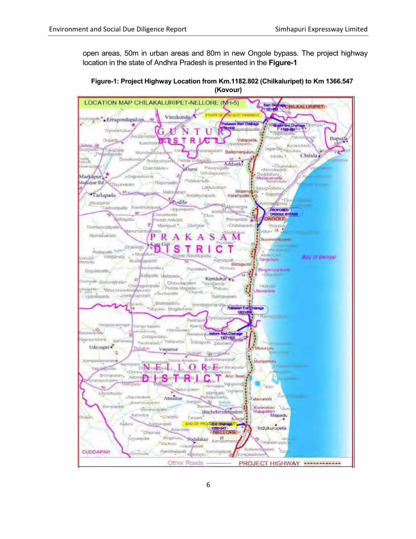
1366.547, near Nellore, covering a total length of 183.62 Km. The entire project road passes through three districts namely Guntur ( totaling to 1.08 Km), Prakasam (totaling to 124.02 Km) and Nellore (totaling to 58.65 Km) Districts in the state of Andhra Pradesh.The project stretch in general passes through plain terrain. The land use along the project road is predominantly dominated by agriculture land followed by Built-up, Industrial/Commercial, barren and Forest land. At few locations it crosses State Highways and other link roads to the nearby villages. The road section also crosses river Penna a subsidiary of river Krishna after Kavali bypass near Nellore. A total of 61 villages spread over three districts namely Guntur, Prakasam and Nellore are located on either side of the project road.
4. The existing Right of Way (ROW) varies from 40 m to 60 m in width in the stretch and has provision for expansion of 4 lanes to 6 lanes. The proposed RoW is 66m in rural and
Environment and Social Due Diligence Report Simhapuri Expressway Limited
6
open areas, 50m in urban areas and 80m in new Ongole bypass. The project highway location in the state of Andhra Pradesh is presented in the Figure-1
Figure-1: Project Highway Location from Km.1182.802 (Chilkaluripet) to Km 1366.547 (Kovour)

Environment and Social Due Diligence Report Simhapuri Expressway Limited
7
5. The proposed widening and strengthening work would mainly involve: ((i) widening of existing four lane road to six lane divided carriageways; (iii) Pavement strengthening and provision of drains, service roads, sidewalks, pedestrian crossing, underpasses, bus bays and truck lay byes, rest areas, toll plazas, street lighting, land scaping and tree plantation and other infrastructure like traffic aid posts, medical aid posts and vehicle rescue posts and telecom system etc.
6. The brief particulars of the subproject are as follows in Table-2:
Table-2: Salient features of the project road (Km.1182.802 (Chilkaluripet) to Km.1366.547 (Kovour))
Type Details Remarks
Concessionaire Simhapuri Expressway Ltd. (SEL)
Location of Project
From Tatapudi village of Chilakaluripet Mandal in Guntur District (Km1182+802) to Kovur Village of Kovur Mandal in SPSR Nellore District (Km1366+547) a section of NH-5 including proposed Ongole bypass from village Mukthinuthalapadu (km 1241+450) to village Pelluru (Km1251+700) of Ongole Mandal of NH-5
Length of the project
Guntur District = 1.079 Km Prakasam District = 123.894 Km (includes Ongole Bypass 10.125km) Nellore District = 58.647
183.620
Administrative Location 3 Districts- Guntur, Praksam and Nellore
Service Road Additional Service Road at 115 Locations Guntur District = Nil Prakasam District=74(27.446 Km) Nellore District= 41 (14.884Km)
84.66 Km on either side
By pass Prakasam District- New Ongole bypass on eastern side of Ongole town
10.125km
ROW 60m in rural areas and 50m in urban areas
Major Bridges 12 Nos
a) 1-New construction at Ch. 4+850 at Ongole bypass
b) 11-Rehabilitation/Repair/Widen
-
Minor Bridges 56 Nos
a) 2- New construction at Ongole bypass including service roads
b) 54- Rehabilitation/Repair/Widen
-
ROB 5Nos.
a) 2-New construction at Ongole Bypass ch. 3+450 & 8+970
-

Environment and Social Due Diligence Report Simhapuri Expressway Limited
8
Type Details Remarks
b) 3- Rehabilitation/Repair/Widening at Ch. 1306+300 , Ch. 1342+300, Ch. 1366+600 (Railway Chainages)
Grade Separated Intersections
4Nos a) Ch. 1218.000 (at Medarmetla) b) Ch. 1240.045 (at Trovagunta Chirala
crossing) c) Ch. 0+700 (Ongole bypass starting) d) Ch. 9+760 (Ongole bypass ending)
Vehicular Underpass
24 Nos a) 1-at Ongole bypass b) 23 Nos along the existing road and
-
Pedestrian/ Cattle Underpass 21 -
Rest Areas 06 LHS& RHS Bus- Byes and Bus Shelter 126 LHS/RHS
Culverts 173 -
Toll Plaza 03
(i)Ch. 1200 (Bollapally) (ii)Ch. 1264 (Tangutur)
(iii)Ch. 1326 (Masnuru)
Source: Monthly Progress Report, December 2011
7. The debt component of the proposed project is being financed by a syndication of loan with lead Bank/Lenders Agent as State Bank of India. SEL has signed a Common Rupee Loan Agreement with a consortium of three banks, the consortium comprises of State Bank of India, IDFC and India Infrastructure Finance Company Limited (IIFCL). On 16th July 2010, IIFCL’s board has sanctioned a loan amount to Rs. 300 Cr. to SEL..
2.
8. National Highway Authority of India (NHIA) has appointed M/s. Simhapuri Expressway Limited (SEL) as the concessionaire for widening and up-gradation of the section of NH-5 from Km 1182+802 to Km 1366+547 for this sub-project. The Concession Agreement (CA) was signed on 15th July 2010 between NHAI and M/s. Simhapuri Express Limited.

Environment and Social Due Diligence Report Simhapuri Expressway Limited
9
3. 9. NHAI has appointed M/S Intercontinental Technocrats Pvt. Ltd. as the independent
consultant for the project.
4. 10. M/s KMC Constructions Limited and M/s. BSCPL Infrastructures Limited has been
assigned the Engineer Procurement and Construction part of the project.
5. 11. M/s Frishmann Prabhu (India) Pvt. Ltd. has been appointed as Lender’s Engineer for the
project

Environment and Social Due Diligence Report Simhapuri Expressway Limited
10

Environment and Social Due Diligence Report Simhapuri Expressway Limited
11
6.
12. National Highway Authority of India (NHAI) through its consultant M/s EGIS BCEOM International in association with EGIS India Consulting Engineers Pvt. Ltd. has prepared the Environmental Assessment and Environment Management Plan. A copy of the EIA/EMP report is given in Appendix-I.
7.
13. The environmental sensitivity of the Chilakaluripet-Nellore section of NH-5 (starting from Tatapudi Village at km 1182+802 and ending at Kovour at km1366+547),from existing 4- lane to 6-lane configuration including a new 6-lane bypass at Ongole with a length of 10.125 km. covering a distance of 183.7 km, has been assessed by reviewing the Environmental Assessment and Management Plan, prepared for the project. The Chilakaluripet-Nellore road corridor is a part of Kolkata-Chennai leg of Golden Quadrilateral corridor. This section of NH-5 from Chilakaluripet to Nellore in the State of Andhra Pradesh is proposed to be taken up for six laning under NHDP Phase-V. The project is proposed to be implemented under Public Private Partnership (PPP) mode and executed as Design, Build, Finance and Operate (DBFO) contracts. The entire project is located in the state of Andhra Pradesh. The project stretch passes through three districts of Andhra Pradesh namely Guntur (Km 1182+802 to Km 1183+881), Prakasam (1183+881 to Km 1307+900) and Nellore (Km 1307+900 to Km 1366+547). The proposed new Ongole Bypass is located in Prakasam District and takes off from Km 1241+450 on NH-5 and terminates at Km 1251+700 on NH-5 after passing on the eastern side of the existing highway covering a total distance of 10.125 Km.
14. The sub-project was visited by the Environmental and Social safeguard specialists of IIFCL during 18th -20th of June, 2012 for field verification of Environmental safeguards as reported in the EIA/EMP reports and consultation with the concessionaire. The site visit photographs are given in Photoplate-I. The environmental sensitivity assessment is given below:
Landuse along the project road is predominantly agricultural and barren. No
major industry is located along the project road.
The project road mainly passes through flat terrain with gently rolling having mean elevation varying between 10 m to 40 m. However some interspersed small hillocks can also be observed around the project stretch;
The project road crosses rivers, nallas, local streams and canals. The major rivers which project crosses are Mudigundi, Musi, Paleru, Maneru and Pyderu. All these rivers and streams are rainfed;
The area along the project corridor is dotted with a number of the ponds / tanks and reservoirs all along the project stretch which are mainly used for

Environment and Social Due Diligence Report Simhapuri Expressway Limited
12
irrigation purpose and some of the ponds and reservoirs are used for fishery. Some of the Ponds fall within the proposed ROW may need to be partially filled for road formation;
There is no any National Park, Wildlife Sanctuary, Tiger Reserves, notified ecologically sensitive area, or any other significant area of ecological interest situated within 15 Km radius except for reserved forest areas hence no impact on such features anticipated due to the project;
The baseline studies showed that there are no known rare, threatened or endangered flora and fauna species within the project area;
The baseline study in EIA Report showed that at six locations, reserved forest patches are located along the project stretch. These Reserve Forests are falling in Prakasam District (Mocherla RF, Mocheral Chalamchatla RF, Chevuru RF) and in Nellore District( Rudrakota RF, Bitragunta RF, & Kothapalli RF). It has been proposed to accommodate the widening within the available ROW in the stretch where the Reserved Forests are located in order to avoid acquisition of reserved forest land into non-forestry purpose. As informed by project developer, if required, Retaining walls will be provided on either side to maintain required formation width for six laning. The forest department has done eucalyptus plantation in these forest patches. There is no natural habitat of wildlife in these forest areas. Hence no impact on these forest areas and wildlife is envisaged.
As informed by project developer, 123204 nos. of tree cutting is involved as
part of the project. Compensatory plantation and landscaping will be carried out in the ratio of 1:3 as per NHAI plantation strategy and in accordance with Guidelines on Landscaping and Tree Plantation specified under IRC:SP:21-2009. The cost provision for felling, and plantation of new saplings has been made;
There are no protected archaeological properties or monuments along the project road alignment;
There are some cultural properties as well as other Government properties/facilities within the RoW that are likely to be affected due to widening and upgradation of project road which will be properly relocated;
There will be 12 major bridges, 56 minor bridges, 5 ROBs, 173 Culverts, 24 no. of Vehicular underpasses, 21 no. of Pedestrian/cattle underpasses, 6 no. rest areas, 126 no. of Bus-bays and bus shelters, 4 no. of Grade Separated Interactions along the entire length of the project road. Out of which, some structures will be newly constructed and some structures will be rehabilitated/repaired/widened;
Public consultations have been conducted during the environmental studies to disseminate the project information and to record the views/aspirations of

Environment and Social Due Diligence Report Simhapuri Expressway Limited
13
the local people along this NH section. Public Hearings were conducted in all the three concerned districts, i.e. Guntur, Prakasam and Nellore. The Public Hearing were conducted at the Office of Revenue Divisional Officer Kavali of Nellore District on 21st June, 2011, on 25th June, 2011 at Tahsildar Office, Ongole of Prakasam District and on 4th August, 2011 at Mandal Parishad Pradmika Paatasala, Tatapudi village, Chilakaluripet Mandal in Guntur District;
Elaborate environmental management and monitoring programme has been suggested for this NH section;
As per EC Letter, a cost provision of INR 14 Crores has been proposed for Environment protection works during construction and operation phase for this project.
8.
15. The sub-project, being highway widening project, can be classified as category B based upon
ADB’s EA requirements as per their Safeguard Policy Statement (2009). This classification is based on the review of the EA report and other available documents with respect to the environmental sensitivity due to project activities.
9.
16. It is required that the sub-project meets the requirements of appropriate Indian legislations by considering appropriate obligations and guidelines of Regulatory Authorities. The sub project should have necessary national and local environmental clearances as well as permits and approvals for project implementation and suitable environmental management plan has been applied. The statutory clearances required as part of the proposed widening and strengthening of NH-5 section between Chilakaluripet-Nellore was assessed and current status of availability of such clearances are given in Table 3.
Table 3: Status of Regulatory Clearances Obtained
Sl. No.
Clearances Required
Statutory Authority
Current Status of Clearance
1 Environmental Clearance
Ministry of Environment and Forests, New Delhi
MoEF has granted Environmental Clearance to this project on 14th November, 2011, Letter no. F. No. 10-58/2010-IA-III.
2 Forest Clearance
State Forest Dept. and Ministry of
Not Applicable Pockets of Reserve Forests at 6 locations along the project corridor have been recorded. These Reserve Forests are: Guntur District: Nil Prakasam District: Mocherla RF, Mocheral
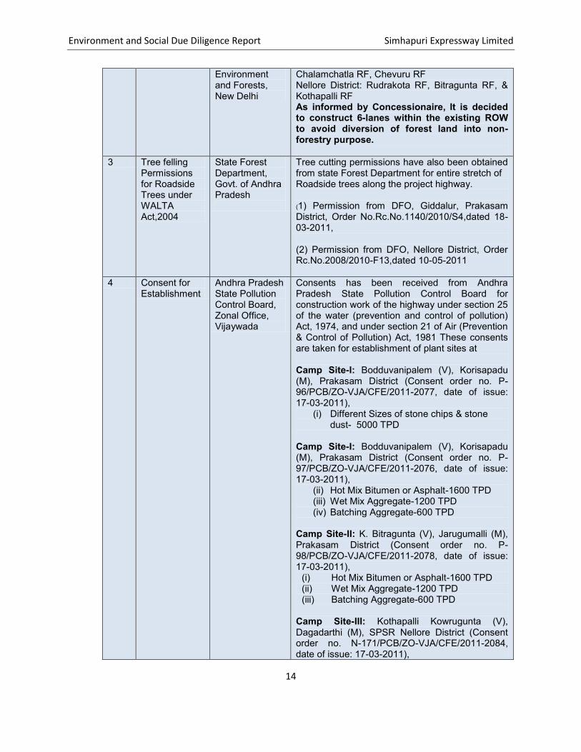
Environment and Social Due Diligence Report Simhapuri Expressway Limited
14
Environment and Forests, New Delhi
Chalamchatla RF, Chevuru RF Nellore District: Rudrakota RF, Bitragunta RF, & Kothapalli RF As informed by Concessionaire, It is decided to construct 6-lanes within the existing ROW to avoid diversion of forest land into non-forestry purpose.
3 Tree felling Permissions for Roadside Trees under WALTA Act,2004
State Forest Department, Govt. of Andhra Pradesh
Tree cutting permissions have also been obtained from state Forest Department for entire stretch of Roadside trees along the project highway. (1) Permission from DFO, Giddalur, Prakasam District, Order No.Rc.No.1140/2010/S4,dated 18-03-2011, (2) Permission from DFO, Nellore District, Order Rc.No.2008/2010-F13,dated 10-05-2011
4 Consent for Establishment
Andhra Pradesh State Pollution Control Board, Zonal Office, Vijaywada
Consents has been received from Andhra Pradesh State Pollution Control Board for construction work of the highway under section 25 of the water (prevention and control of pollution) Act, 1974, and under section 21 of Air (Prevention & Control of Pollution) Act, 1981 These consents are taken for establishment of plant sites at Camp Site-I: Bodduvanipalem (V), Korisapadu (M), Prakasam District (Consent order no. P-96/PCB/ZO-VJA/CFE/2011-2077, date of issue: 17-03-2011),
(i) Different Sizes of stone chips & stone dust- 5000 TPD
Camp Site-I: Bodduvanipalem (V), Korisapadu (M), Prakasam District (Consent order no. P-97/PCB/ZO-VJA/CFE/2011-2076, date of issue: 17-03-2011),
(ii) Hot Mix Bitumen or Asphalt-1600 TPD (iii) Wet Mix Aggregate-1200 TPD (iv) Batching Aggregate-600 TPD
Camp Site-II: K. Bitragunta (V), Jarugumalli (M), Prakasam District (Consent order no. P-98/PCB/ZO-VJA/CFE/2011-2078, date of issue: 17-03-2011),
(i) Hot Mix Bitumen or Asphalt-1600 TPD (ii) Wet Mix Aggregate-1200 TPD (iii) Batching Aggregate-600 TPD
Camp Site-III: Kothapalli Kowrugunta (V), Dagadarthi (M), SPSR Nellore District (Consent order no. N-171/PCB/ZO-VJA/CFE/2011-2084, date of issue: 17-03-2011),

Environment and Social Due Diligence Report Simhapuri Expressway Limited
15
(i) Different Sizes of stone chips & stone
dust- 1200 TPD (ii) Hot Mix Aggregate-800 TPD (iii) Wet Mix Aggregate-1000 TPD (iv) Batching Aggregate-150 TPD
5 Consent for
Operation Andhra Pradesh State Pollution Control Board, Zonal Office, Vijaywada
Consents for Operation has been received from Andhra Pradesh State Pollution Control Board for construction work of the highway under section 25 of the water (prevention and control of pollution) Act, 1974, and under section 21 of Air (Prevention & Control of Pollution) Act, 1981 These consents are taken for establishment of plant sites at Camp Site-I: Bodduvanipalem (V), Korisapadu (M), Prakasam District (Consent order no. P-80/PCB/ZO-VJA/CFO/W&A/2011-2667, date of issue: 24-03-2012),
(i) Different Sizes of stone chips & stone dust- 5000 TPD
Camp Site-I: Bodduvanipalem (V), Korisapadu (M), Prakasam District (Consent order no. P-82/PCB/ZO-VJA/CFO/W&A/2012-2659, date of issue: 24-03-2012),
(v) Hot Mix Bitumen or Asphalt-1600 TPD (vi) Wet Mix Aggregate-1200 TPD (vii) Batching Aggregate-600 TPD
Camp Site-II: K. Bitragunta (V), Jarugumalli (M), Prakasam District (Consent order no. P-81/PCB/ZO-VJA/CFO/W&A/2012-2660, date of issue: 24-03-2012),
(iv) Hot Mix Bitumen or Asphalt-1600 TPD (v) Wet Mix Aggregate-1200 TPD (vi) Batching Aggregate-600 TPD
6 Quarry Approval
Dept. of Mines & Geology, Govt. of Andhra Pradesh
Quarry Permits/Licenses have been obtained for carrying out road metal Quarrying from Dept. of Mines & Geology, Govt. of Andhra Pradesh. (1) Permission proceedings. No.
9315/Ql2010,dated16-05-2011 for the location of Bodduvanipalem (v), Korisapadu (M), Prakasam District
(2) Permission proceedings. No. 2635/Ql2011,dated 09-05-2011 for the location of Velupodu (v), Dagadarthi (M), S.P.S.R. Nellore District
7 Borrow Area
Permissions Village Panchayat and Land Owners
No Objection Certificate from Village Panchayat and Consent from Private Land Owners has been taken for Borrow Areas used for the project.

Environment and Social Due Diligence Report Simhapuri Expressway Limited
16
Sample Copy of consent and list of Borrow Areas has been attached.
8 Grant of Explosive License for possession of Explosives and use of explosives in Quarrying Operations
Joint Chief Controller of Explosives, Egmore, Chennai
No Objection Certificate has been received vide permission no. D.Dis.C5/107/2011, dated: 07-04-2011 from Joint Chief Controller of Explosive’s Office, Egmore, Chennai for possessing and use of Explosives in Mining lease site under Explosives Act and Rules, 2008.
9 Factory Inspector’s Permission for setting up Construction Plants
Factories Department, Govt. of Andhra Pradesh, Hyderabad
Plant site plans have been approved by Director of Factories and necessary measures have been suggested to undertake at plant sites under the requirement of Factories Act, 1948.License to work as a Factory has been obtained for plant site in Nellore District vide Permission Letter No. D.Dis/DI/NLR/1080/11,dated 15-03-2011 from Inspector of Factories.
10 Labour License
Office of Assistant Labour Commissioner (Central),Hyderabad , Andhra Pradesh
The establishment has been registered under the provisions of the Building & other Construction Workers( Regulation of Employment Conditions of Services Act,1996 and rules made there under vide Permission No. 57/90/2011-ALC-VJA, dated: 24.6.2011 labour license has been obtained for the project under the Contract Labour (Regulation and Abolition) Act, 1970 vide Permission No. 46/119/2011-ALC-VJA, dated : 24.6.2011
17. Copies of all relevant clearance, approvals and permits are given in Appendix-II.
10.
18. Public participation and community consultation has been taken up as an integral part of social and environmental assessment process of the project. The discussions process established for the project has employed a range of formal and informal consultative tools including in depth interviews with key informants, on-site consultation and meetings. The consultations were carried out at 15 places with an objective to create awareness about the project among the people and district administration and to understand the public perception and different environmental and social issues within the project stretch. Village level consultations were held at Marturu, Gollapalli, Maddipadu, Maddurupadu and Gauravaram apart from local level consultation in 15 places all along the project stretch.
19. The main points of discussion were concentrated on environmental awareness, afforestation, health, safety, shifting of structures, etc. Majority of the population are in favour of the project.
Environment and Social Due Diligence Report Simhapuri Expressway Limited
17
However, the major concern expressed by them were safety associated with the operation of the existing four lane project, acquisition of properties and issue of compensation, protection of water bodies located in close vicinity of the project road, protection of trees and plants which are beyond the formation width, but very close to the project road, protection of cultural properties. Most of the people in the settlement area demanded provision for pedestrian/ cattle crossings as well as underpasses for movement of local traffic including tractors, trolleys carrying agriculture produces. They are also of the opinion to involve local labours in construction.
20. Formal Public Hearings as part of Environment Clearance Process were conducted at the Office of Revenue Divisional Officer Kavali of Nellore District on 21st, June, 2011, on 25th June 2011 at Tahsildar Office, Ongole of Prakasam District and on 4th August, 2011 at Mandal Parihad Pradmik Patasal, Tatapudi village, Chilakaluripet Mandal in Guntur District. Copies of newspaper advertisements and minutes of public hearing proceedings are attached as Appendix-III.
21. The Public Hearings has been conducted in all the three concerned districts, i.e. Guntur, Prakasam and Nellore with state pollution control board and the Minutes of the Public Hearing Proceedings and response of NHAI is enclosed as APPENDIX-I of EIA report. As reported in EIA report, the issues raised by public have been addressed appropriately in Environmental Management Plan.
11.
22. Since the alignment is to follow the existing 4 lane highway; hence there is no other alternative design. Therefore the analysis of alternative has been carried out ‘with project’ and ‘without project’ scenarios for the only one possible alternative i.e. to follow the existing alignment only. As reported in EIA report,407.78 Ha hectares of additional land is required to accommodate 6 lane configuration, service lane, bus bays, truck lay byes, toll plaza, rest areas, entry & exit points etc. and new Ongole bypass. Keeping in view, the site conditions and the scope of development of the area, the ‘With’ and ‘Without’ project scenarios has been compared for the lone existing alignment. The alternative assessment is summarized here:
23. “Without Project Scenario”: The capacity of the present highway is insufficient for handling increasing volume of traffic over time. It will impact on traffic movements resulting in lowered traffic speed and increase in accidents due to less traffic safety. Although in “no project scenario”, there won’t be any land acquisition, and no cutting of trees but the population growth, increase in traffic volumes and the economic development along the corridor would continue to occur and will exacerbate the already critical situation. The existing unsafe conditions and the adverse environmental consequences, in terms of environmental quality along the highway, would further deteriorate in the absence of the proposed improvements. Therefore, the no-action alternative is neither reasonable nor prudent, as it would amount to failure to initiate any further improvements and impede economic development.

Environment and Social Due Diligence Report Simhapuri Expressway Limited
18
24. “With Project Scenario”: This option will improve the capacity of the highway of traffic movement for future and no congestion envisaged. Traffic speed will increase at a uniform rate and no future bottlenecks are envisaged. Traffic safety will improve substantially due to widened road, median and proper design of intersections etc. Due to new design, drainage condition will improve along entire stretch. Improved facilities e.g., parking, service road etc. will be provided in all sections. Although there will be acquirement of new land, removal of trees & vegetation due to widening, increase in dust pollution & vehicular emission, partial filling of Ponds/Water Tanks falling within proposed RoW which may have some environmental impacts. But the road widening option will improve quality of life of the local people, better access to healthcare and other social services, flourish in trade and commerce, better way side amenities and increase in ground water recharge due to proposed rainwater harvesting structure etc.
25. An analysis of “With” and “Without” Project scenario reveals that the positive impacts
outnumbered the negative impacts due to the proposed development. The negative impacts are envisaged only during the construction period which will be temporary in nature and of short duration. Further, mitigation measures will be adopted to limit the impacts during the construction phase. The proposed expansion will aid in infrastructure development and will act as a catalyst to boost the economic progress. As reported in EIA report, It was revealed during discussions with various stakeholders that safety is a major concern along the existing highway section. The safety aspect will be enhanced considerably with the provision of service lanes, pedestrian crossings, street lights, additional systematically designed bust stands, rest areas, bus bays and truck lay byes, service roads which are the significant part of the project. That will ensure smooth traffic, it is envisaged that commercial establishments will revive their business and this will in turn boost the economic development.
12.
26. As per article 5 under obligations of Concessionaire in concession agreement, the concessionaire shall comply with all applicable laws and applicable permits (including renewals as required) in the performance of its obligations under this agreement. It is also mentioned that Concessionaire shall ensure and procure that its contractors comply with all applicable permits and applicable laws in the performance by them of any of the Concessionaire’s obligations under this agreement. Concession agreement for this project is attached as Appendix-IV. Safety requirements are given under Article 18 in which it is specified that the Concessionaire shall comply with the provisions of applicable laws and applicable permits and conform to good industry practices for securing the safety of the users. In particular, the Concessionaire shall develop, implement and administer a surveillance and safety programme for providing a safe environment on or about the project highway, and shall comply with the safety requirements set forth in Schedule-L.
27. Compliance with applicable permits has also been specified in Schedule -E of Concession agreement. As per the schedule- L of CA safety requirements apply to all phases of construction, maintenance with emphasis on identification of factors associated with accidents,

Environment and Social Due Diligence Report Simhapuri Expressway Limited
19
consideration of the same, and implementation of appropriate remedial measures. The concessionaire shall abide with applicable laws and applicable permits, manual for safety in road design, issued by MORTH, relevant standards/guidelines of IRC relating to safety In accordance with the provisions of CA and good industry practices relating to safety of users. NHAI shall appoint an experienced and qualified firm or organization as a safety consultant for the project for carrying out safety audit of the project highway in accordance with the safety requirements.
13.
28. Simhapuri Expressways Limited (SEL) has awarded the EPC works for this project to two contractors. M/s. BSCPL Infrastructure Limited has been awarded the construction job of section from Km 1182.802 to Km 1266.00 and M/s. KMC Constructions Limited has been awarded the construction works from Km 1266 to Km 1366.547. As per Lenders Engineer’s report for December month, physical progress of 10.65 % has been shown to be achieved for this project upto the period of October, 2011 which concessionaire has done with his own resources.
29. EPC Contract for this project has been attached as Appendix-V. Both the contract copies are similar in terms of clauses mentioned for environmental management & safety. As per both the contract copies under clause 2.2, under heading of Permits, Licenses or Approvals, the Employer shall provide reasonable assistance to the contractor at the request of the contractor in obtaining any permits, licenses or approvals required by the laws of the Country which the Contractor is required to obtain. Under Clause 4.8 for safety procedures, contractor will undertake traffic management during the Construction period including but not limited to barricading, signages, lighting and any other safety precautions and measures as per the Employer’s requirements.
30. As per Clause 4.18 for Protection of the Environment, the Contractor shall develop an Environmental Management Plan with the objectives that the works shall endeavor to cause minimum impact of the environment; the Contractor shall, in all operations, economize on natural resources and energy; the works shall be carried out considering the importance of human health and safety; all legal requirements and regulations related to the environment shall be complied with; the contractor shall train, inform and stimulate its staff towards involvement, participation and responsibility in environmental matters; the contractor shall make sure that high environmental standards are implemented by subcontractors, business partners and suppliers; the measures for the protection of the environment will be part of the project quality management plan. Under Clause 4.23 for Contractor’s Operations on Site, its mentioned that Contractor shall at all times be responsible for ensuring safe operation of the project highway. The Contractor shall also maintain, during the construction period and defects notification period in conformity with Good Industry practices, all stretches of approach roads, over-passes, under-passes or other structures situated on the site but not forming part of the carriageway.

Environment and Social Due Diligence Report Simhapuri Expressway Limited
20
14.
31. As part of the project, detailed EMP measures have been undertaken including a budget of 14 Crores (as given in EC Letter) during construction stage (3 years) and operation phase (5 years) for implementing the same. The EMP budget exclusively includes the following measures:
Compensatory Afforestation and Landscaping/Plantation in the median/ Greenbelt development during Construction & Operation Phase;
Relocation of water resources; Provision of rainwater harvesting structures; Environmental Protection Measures in the construction sites; Environmental Training; Corporate Social Responsibility; Enhancement of cultural features; Environmental Quality Monitoring during construction and operation Phase;
15.
32. The environmental management plan as appeared in EIA report is given in Appendix-I, which describes the proposed mitigation measures that would be adopted during the construction and operation stages of the project. Detailed and implementable Environment Management Plan of Concessionaire has been attached as Appendix-VI.
15.1. CONCESSIONAIRE AND EPC CONTRACTOR’S HSE PLAN: 33. The Occupational Health, Safety and Environment (HSE) Manual has been developed for
managing the HSE issues at construction sites for Simhapuri Expressway project. The purpose of the OHSE Manual is to provide guidelines to the Concessionaire, EPC Contractor (the Sub-Contractors) and Engineer/PMC team that all are responsible for performing work and supervise the Contract in conformance with all environmental, health and safety rules and regulations of Andhra Pradesh State Govt. and Govt. of India. This document works as a guidance manual for implementing good industry practices w.r.t. environmental management, worker safety and accident/hazard prevention at work site. The concessionaire is committed to comply with good practices related with environment & safety during development of its projects and has adopted Health, Safety and Environment Policy which is attached as Appendix-VII.OHSE Manual prepared for the project has been attached as Appendix-VIII. As reported by concessionaire, Regular Traffic awareness programs are being conducted along the highway. Some Details for recent safety awareness activities are enclosed in Appendix-IX.
34. Under Emergency Response Plan, Emergency Response Protocol describes categorization of different emergency events and decision making responsibilities during each event. Rescue and medical aid services are described which includes provisioning of different emergency services like ambulance services, fire tender services, emergency equipment facilities etc. The emergency procedures are given which shows the involvement of different parties/ agencies

Environment and Social Due Diligence Report Simhapuri Expressway Limited
21
and decision levels. Emergency Response Plan prepared for Simhapuri project has been attached as Appendix-X.
35. Accident monitoring system is in place to assess the rate of accidents in project road section and to take the preventive measures. This monitoring is essential to judge the effectiveness of traffic safety measures implemented during construction. Monthly reporting system is developed which gives details of chainage wise accident location, nature of accident, severity of accident and no. of affected persons. Sample copy for Monthly accident/incident summary data has been attached as Appendix-XI.
15.2. EMP COMPLIANCE STATUS: 36. As per Lender’s Independent Engineer Monthly Progress Report of December 2011, its
reported that the Concessionaire is complying with the environmental laws in terms of the EMP manual document finalized by M/s. Feedback Infrastructure Services Pvt. Ltd. and the same has been implemented for the project. Concessionaire has been advised to continuously monitor the renewal of licenses and clearances. Lender’s Engineer has also reported that the project is viable with minimum risk and most of the required permits and clearances have already been obtained. The work has already been started at number of locations and making good progress. Safety Plan has been submitted to the Independent Engineer and a separate team has been deployed by the concessionaire to monitor the safety aspects of the project.
15.3. ENVIRONMENTAL MONITORING: 37. Monitoring of environmental quality during construction and during operation reflects the
success of implementation of the mitigation measures and it also provides a chance to review the suggested measure and improve upon the measures. The environmental monitoring is primarily the responsibility of the EPC contractor. The environmental monitoring plan proposed for this project as given in EIA report,Chapter-9 for EMP, covers various environmental monitoring parameters, monitoring frequency and cost involved for carrying it out during pre-construction , construction (3 years) and operation stages (5 years) of the project. The job of environmental monitoring for Simhapuri Expressway project has been outsourced to an Environmental Laboratory namely M/s. Vision Labs based at Hyderabad. The field reports of various environmental components will be received at quarterly basis. IIFCL has requested to provide the latest copy of Environmental Monitoring report.
15.4. INSTITUTIONAL FRAMEWORK FOR EMP IMPLEMENTATION: 38. The project institutional framework as given in the project EMP indicates that the overall
implementation responsibility of the EMP lies with the Project Implementation Unit (PIU); Project Director at PIU is supported by the Environment Officer of NHAI. As per concession agreement, NHAI shall appoint the safety consultant for carrying out safety audit of the project highway in accordance with the safety requirement and shall take all other actions necessary for securing compliance with safety requirements. The Independent Engineer (IE) shall assist the NHAI with the implementation of Project. Environmental Expert of the IE shall be the key personnel to ensure the successful implementation of EMP provisions. The position is leveraged to ensure

Environment and Social Due Diligence Report Simhapuri Expressway Limited
22
that the Contractor complies with the various EMP requirements. The Project will require continuous environmental supervision from the IE‟s side.
39. The General Manager of Concessionaire with the assistance of Project Manager of Contractor
and supporting Environmental / Safety Engineer shall be responsible for ensuring compliance of safeguard measures through Contractors under the supervision of concessionaire and will be reporting to the regulatory bodies and competent authority for certifying that relevant environmental safeguard measures have been complied with during project implementation. Concessionaire shall coordinate with Contractors for complying the requirements of various environmental safeguard measures through supervision, monitoring and reporting on the same. The General Manager, Project Manager of concessionaire, Environmental / Safety Engineers of Contractor and their Field Representatives shall be responsible for discharging the duties of Supervising EMP compliance. The PMC/Engineer shall monitor the implementation of the work on behalf of Concessionaire of the Project. The Contractor will be responsible for planning all Environmental Management Plan (EMP) activities. The institutional arrangement made for the project implementation is given in Figure 2. HSE Organogram for SPV,PMC and EPC Contractor has been attached as Appendix-XII.

Environment and Social Due Diligence Report Simhapuri Expressway Limited
23
Figure 2: Overall Implementation Framework for EMP Implementation
Direct Indirect
Project Manager
(Contractor)
Environmental Officer
(Contractor)
Team Leader
(Independent Engineer /
Consultant)
Environmental Expert
(Independent Engineer /
Consultant)
General/Chief Project Manager
(Concessionaire)
Environmental Officer
(Concessionaire/PMC)
Project Director
(Project Implementation
Unit, NHAI)
Environmental
Officer
(SHAI)
State Pollution
Control Board
MoEF,
Regional Office

Environment and Social Due Diligence Report Simhapuri Expressway Limited
24
16.
40. A site visit was undertaken by IIFCL’s Environmental and Social Safeguard specialists during 18th -20th of June, 2012 to review the implementation of the project environmental safeguards. During the site visit it has been observed that:
Regular water sprinkling is being done in high dust generation areas like road
construction sites and crushing operation areas. As the construction work is in early stage so Rain Water Harvesting construction
work has not been started till date. Nearly Half of the tree cutting has been completed on road side and tree stumps
were seen falling alongside the road. Reserve forest area present at some of the project sections alongside the road
has not been diverted as the sufficient land is available for widening the project road. Retaining walls will be constructed in forest sections, if required as informed by the developer during the site visit.
Topsoil stockpiling has also been practiced during soil excavation activities for this project.
Due to early stage of construction, Avenue plantation work has not been started. As informed by developer, tree plantation plan is under finalization stage.
Proper traffic diversions and appropriate signages are being provided at the site to prevent any disruption to the highway traffic.
Workers are being provided with the required safety gears to be worn during execution of work.
At construction plant sites for dust pollution control, crushers have been provided with wind screens and water sprinkler at the start of crushing operation in crusher equipment and Hot Mix Plants have been provided with Bag House filter.
For recycling bituminous aggregate material generated from old road demolishing in new road construction, HMP facility has been installed at Camp Site-I which is being used for recycling bitumen and aggregate from waste material. As informed by EPC Contractor, this type of facility has been established first time in India.
Necessary barricading and safety precautions for deep excavations are also being ensured. Work safety signages have been provided throughout the project highway.
The Labour camps are provided with adequate drinking water, canteen and sanitation facilities. Provision of sanitation facility and septic tanks have been made.
Emergency patrolling vehicle has been provided and tie up has been done with local hospital for emergency ambulance facility.
Efforts have been taken for protecting ponds/water tanks falling alongside the project road during widening by realigning the road at these locations. At one location of Ch. 1260 KM, Pond named Punta at Nayadupalam will be filled in road widening which will be constructed again at nearby another place for villagers.

Environment and Social Due Diligence Report Simhapuri Expressway Limited
25
On the demand of local people at Valluru- Ch. 1256 km, Vehicular Underpass will be provided in front of temple falling on the road which was not under earlier scope of work given by NHAI.
As reported by concessionaire, Regular Traffic awareness programs are being conducted along the highway. 23rd Road Safety week was celebrated during Jan. 1 to Jan. 7 ,2012 and pamphlets were distributed consisting of safety aspects both in English and Telugu throughout the stretch. Some Details for safety awareness activities are enclosed in Appendix-IX.
41. The site visit photographs are given for some of the environmental safeguard measures
and progress of construction work details are given in Photoplate-I.
17.
42. Based upon the available documents, the conclusions for the sub-project are given below:
The sub-project has been prepared by NHAI as per its own funding requirement and not in anticipation to ADB operation.
The sub-project has obtained necessary national and local level environmental clearance as well as permits and approvals for project implementation as given in Appendix-II.
Concessionaire has confirmed that pending statutory environmental clearances /approvals /consents are obtained and renewed, as per applicability;
The sub-project does not affect any eco-sensitive zones as declared by MoEF. Also the project does not pass through any national park or wild life sanctuary area. No historical or cultural monuments are affected due to this road project.
The Reserve Forest Stretches falling alongside the road has not been diverted and road will be widened within the available RoW. If required, Retaining walls will be constructed in forest sections as informed by the developer during the site visit.
Concessionaire has confirmed that continued compliance is being carried out w.r.t. the terms and conditions stipulated for according statutory environmental clearances /approvals /consents by the facility owner and the civil works contractors;
The sub project may also have a positive GHG emission reduction due to less fuel consumption for the same traffic density.

Environment and Social Due Diligence Report Simhapuri Expressway Limited
26
The institutional arrangement available for the implementation of EMP appears to be adequate as there is a sufficient number of staff available for implementing and monitoring the EMP implementation.
Based on the due diligence findings, it can be deduced that the sub-project has no significant environmental safeguard issues.
The Sub-project, therefore does not appear to involve reputational risk to Asian Development Bank funding on environmental safeguards and recommended for funding under the proposed project.

Environment and Social Due Diligence Report Simhapuri Expressway Limited
27

Environment and Social Due Diligence Report Simhapuri Expressway Limited
28
18.
18.1. METHODOLOGY ADOPTED FOR SOCIAL COMPLIANCE REVIEW: 43. The due diligence study for the subproject was initiated by IIFCL after the review of Social
Impact Assessment & Resettlement Action Plan (RAP), Lenders’ Engineers (LE) Report, Environmental Clearance received for the sub-project, compliance report of additional TOR requirements as per the proceeding of Environmental Committee and the information received from the Concessionaire regarding the land requirement for the project and the local labour employment details. A copy of RAP report is given in Appendix-VIII. Following documents were referred for the Social Safeguard Compliance review:
Social Impact Assessment & Resettlement Action Plan (RAP); Environment Impact Assessment Report (EIA); Environment Management Plan (EMP); Monthly Progress Report (MPR), December 2011; Environment Clearance Certificate
19. 44. Efforts have been made during the planning stage to minimize the negative social impact
of the sub-project. To avoid any impact on built up area, provision for underpass and bypasses have been made during the project planning stage. In this regard, Ongole bypass of a total length of 10.250 km, from village Mukthinuthalapadu (km 1241+450) to village Pelluru (Km1251+700) of Ongole Mandal of NH-5, has been proposed to minimize the social impact.
20. 45. As mentioned in RAP, the sub-project requires 270.98 Ha. of additional land (186.02 Ha
for main alignment and 84.96 Ha for Ongole bypass) which includes land for widening and improvement of the existing 4-lane to 6-lane road, new underpasses, bypass at Ongole, flyovers, etc. The detail of the district wise land requirement across the project road sections is given in the Table-4 below.
Table 4- The details of district wise Land requirements
Sl. No District Area Required (Ha) Area by Ownership (Ha)
Private
Government
A. Main Alignment 1 Guntur 0.5619 0.3722 0.1897 2 Prakasam 112.1955 86.3884 25.8071 3 Nellore 73.2645 43.2864 29.9811
Sub Total 186.0219 130.047 55.9779 B. Ongole Bypass
4 Prakasam 151.4380 54.5204 30.437

Environment and Social Due Diligence Report Simhapuri Expressway Limited
29
Grand Total 270.98 184.5674 86.4149 Source: SIA & RAP Report
46. A total of 61villages of three districts namely Guntur, Prakasam and Nellore is being impacted due to the sub-project. The land acquisition status is given in table-5 below, which shows that 3D notification has been published in all the villages but 3G publication and award is under progress. The district wise land acquisition status is given in the below Table 5.
Table 5- District wise Land Acquisition Status
No. of District
No of Village
3D Notification 3G Publication Award
Published To be Published Published To be
Published Passed To be Passed
Guntur 2 2 0 2 0 2 0
Prakasam 43 43
0 38
5 27 11
SPSR Nellore 16 16
0 16
0 15 1
Total 61 61 0 56 5 42 12
Source: Information received from the Developer
47. During the site visit, it was informed by the concessionaire that they are in total possession of 82.69% of required land (Appendix-XIV A). About 18.31% of the remaining land has also been handed over to them by NHAI but the acceptance of the same is pending due to a joint verification as requested by the Concessionaire. The Concessionaire has requested NHAI to authorize a representative for joint inspection and to validate the site details as per requirement. The copy of the land handover letter provided to the Concessionaire by NHAI and the letter issues by the Concessionaire requesting a joint inspection is attached as Appendix XIV B and Appendix XV respectively.
48. As informed by the concessionaire, there are four pending litigation cases related to land acquisition and compensation. All the cases are being dealt by the Competent Authority. The detail of the pending litigation cases is given in the following table .
Table 6- Status of pending litigation cases related to land acquisition and
compensation
Sl. No.
Location Village Case Status
1. 1225.000 Thimmanapalem An extent of 50 cents acquired at the time of 2-lane to 4-laning.
The case is pending before the DC for

Environment and Social Due Diligence Report Simhapuri Expressway Limited
30
Compensation has been received by the awardee as per the original award. But later the awardee filed an appeal before the Arbitrator/ District Collector, Ongole, for enhancement of the compensation.
hearing.
2. 1285.250 Karedu Survey number 372/1A has been acquired to an extent of 18 cents. But compensation could not be paid due to pending family dispute.
The case is currently pending in additional District Judge court.
3. 1356.300 Bodduvaripalem Survey Number 219/1A has to be acquired to an extent of 50 cents. Notification has been issued. Rice Mill is existing in the said Survey Number and the High Court and obtained Stay-Order for not dismantling the Rice Mill.
The Honorable High Court has issued Order withdrawing the said Survey Number from 3A notification and directed the competent Authority to verify the connected records about the classification of land and take further necessary action.
4. 1208.600 Renangivaram For the land with survey number 7/5A, 7/6A1, 2, 7/6A2A2, compensation has been withheld as a case is pending in the Principle Junior Civil Judge Court –Addanki covered by OS number 292/07 and IA Number:3006/08
The case is currently pending and the compensation amount is going to be deposited in the court.
Source: Information received from the Developer

Environment and Social Due Diligence Report Simhapuri Expressway Limited
31
21. 49. As mentioned in RAP, 1104 structures are affected due to the subproject. Out of the total
affected structures 946 numbers are private, 117 numbers are government and 41 structures are community structures in the form of religious and other properties.
50. Land acquisition which results in complete or partial displacement of about 1070 private structures. Out of the total affected 505 numbers are residential, followed by 407 commercial, and 129 numbers are both residential and commercial. In addition to the above a considerable number 29 of affected structures are found to be compound walls, security rooms, bathrooms, and cattle sheds etc. The details of affected structures are given in page No.10 of Appendix-XIII.
22.
51. As informed by the concessionaire, no indigenous people are being affected due to the sub project.
23. 52. During the review of the Resettlement Action Plan (RAP) it is found that provisions have
been made to adequately compensate the affected people for loss of land and structures as per the applicable national policies. The Resettlement Action Plan (RAP) report has been prepared as per “ The National Rehabilitation and Resettlement Policy 2007” (NRRP – 2007). The details of compensation have been given in SIA & RAP report (Appendix- XIII). The estimated Resettlement and Rehabilitation budget as mentioned in RAP is given in Table-7.
Table 7- Resettlement &Rehabilitation Budget
Item Amount (in Rs.) Land Structure Total Compensation 954062200 250943944 1205006144 Assistance 286218660 21400000 307618660 Support for implementation of RAP (Lumpsum)
- - 5,000,000
M & E consultant (Lumpsum) -- - 2,500,000 Sub Total - - 1,520,124,804 Annual Inflation accounted for @ 5 % - - 76006240 Contingency @ 10 % of the total Cost - - 152012480 GRAND TOTAL 1,748,143,524 Source: Resettlement Action Plan
53. The compensation for the loss of land has been paid entirely under the mandate of NHAI
considering the market value obtained from the Revenue Department of the state.

Environment and Social Due Diligence Report Simhapuri Expressway Limited
32
24. 54. The subproject is a linear project, and due to land acquisition the APs are losing part of
their land. However the focus of restoration of livelihoods is to ensure that the Affected Persons are able to “regain their previous living standards”.
55. As informed by the concessionaire, the subproject generated job opportunity to 700 peoples which includes local people, people from villages outside the project area and the project affected people. They are employed as labours for various construction activities and also for the job of as security guards and office assistants,. The component wise local employment generated during the operation phase has been given in below Table-8:
Table-8: Local Employment Generated at the sub project
Component
wise
No of worker employed Total Outside the Project
Area Local Labour
employed Skilled 20 180 200 Semi-Skilled 14 226 240 Unskilled 5 252 257 TOTAL 39 658 697
Source: Information provided by the concessionaire
25. 56. To create awareness about the project among the people and district administration and
to understand the public perception and different environmental and social issues within the project stretch, formal Public consultation has been carried out for this subproject with the objectives of minimizing probable adverse impacts of the project through alternate design solutions. Public consultations were held at five village and towns namely Marturu, Maddipadu Gundlapalli, Gauravaram and Muppavaram on 11th, 25th, 27th October 2007 and 7th and 11th November 2007 respectively. The details of the village level public consultation are given in chapter 6- of Appendix-XIII. In addition to the village level consultation, 15 local level consultations were also done all along the project road.
Table-9: Photographs of public consultation carried out during the
project planning stage

Environment and Social Due Diligence Report Simhapuri Expressway Limited
33
Public Consultation at Tettu Village People Participation in Tettu.
Public Consultation at Mathur village Public Consultation at Mahur village
Public Consultation at Ongola town Public Consultation at Ongole town

Environment and Social Due Diligence Report Simhapuri Expressway Limited
34
57. Public Hearing notice has been published in The Eenadu and the Sakhi in the vernacular language i.e., Telugu. The details of the minutes of the Public Hearing is given in Guntur, Prakasam, and Nellore district is given in Appendix-III attached with ESDDR.
26. 58. As informed by the Concessionaire during the site visit, 47 religious structures are being
affected due to the project road which includes temples, church, mosque, compound walls of religious properties, statues and graveyards. A detailed survey of all the CPR falling within the proposed ROW has been conducted by the concessionaire and effort has been made by them to minimize the impact by adjusting the civil work wherever possible without affecting the structure. The shifting requirement based on the survey by the concessionaire is attached as Appendix XVI.
59. Compensation for the loss of religious structures is being paid by the Concessioning Authority. As informed by the concessionaire, they will help the local people in the relocation of religious structures. Since the physical progress of the project is nearly 20 %, the relocation of temples has not started yet.
27. 60. As informed by the developer, the grievances received from the local people are dealt by
the Concessioning Authority. A copy of the action taken against the public grievances received is attached as Appendix XVII. The details of grievances received from the local people and the action taken to mitigate the grievances is given in the below table:
Table 10: Status of Grievances received from the local people Sl. No.
Location Grievances Status
1. Stretch between Kavali to Nellore, Chainage km. 1318.000 to km. 1366.547
To meet the necessary maintenance requirements in the project stretch.
Concessionaire has complied to the recommendations as per the provisions of Schedule-K as recommended by Independent Engineer after having carried out physical survey of the said stretch.
2. Near Valluramma Temple at Valluru village, Chainage km. 1256.200
Public demand received for the construction of a flyover near Valluramma temple.
Joint inspection has been carried out in the presence of Independent Engineer and technically found that there is no requirement to build a flyover. Instead a Vehicular Underpass
Environment and Social Due Diligence Report Simhapuri Expressway Limited
35
(VUP) has been considered to be proposed to be built in front of the temple for which the design is yet to be submitted to the Independent Engineer in pending anticipation of permission to be procured from the Department of Irrigation to dismantle the existing minor bridge at the same location.
3. Naidupalem village, Chainage km. 1260.000
Construction activities are disturbing the existing pond which is used for supply of drinking water.
It is mutually agreed with the villagers to shift the tank from the existing location and extend it beyond the proposed ROW. The work for the same is under progress.
Source: Information from the Concessionaire
28. 61. The Concessioning Authority, National Highway Authority of India (NHAI) acknowledged
HIV/AIDS as a corporate social responsibility and has taken the lead in association with the WB, ADB & NGOs on HIV/AIDS awareness programs to truckers and migrant workers. NHAI launched an awareness program called "Pathik Mela" on two national highways. A similar program has been proposed in the EIA report where there target group may be truck drivers, commercial sex workers and the communities surrounding the truckers. Such program can be organized from time to time at different location along the project section. A separate budgetary provision of Rs. 2.4 Crore has been made for carrying out various CSR programmes in the project.
29. 62. As mentioned in the RAP, for better monitoring of the R&R issues, a separate budgetary
provision of Rs.2, 500,000/-has been earmarked in the Resettlement and Rehabilitation budget.
30. 63. A site visit was undertaken by IIFCL’s Environmental and Social Safeguard specialists
during 18th-20th of June 2012 to review the implementation of the project social safeguards. During the site visit it has been observed that:

Environment and Social Due Diligence Report Simhapuri Expressway Limited
36
Concessionaire has taken efforts to minimize the impact on the religious properties. In this regard, a detailed survey of all the CPR falling within the proposed ROW has been done by the concessionaire and effort has been made by them to minimize the impact by adjusting the civil work wherever possible without affecting the structure.
The religious structures will be relocated by them based on the availability of land. Since the physical progress of the project is nearly 20 %, the relocation of temples has not started yet.
Local labour has been employed for skilled and unskilled activities.
Proper traffic diversions and appropriate signages are being provided at the site to prevent any disruption to the highway traffic.
Construction work is only being carried out after the affected structures are vacated by their owners.
64. The site visit photographs are given in Photoplate-II.
31. 65. Based upon the available documents it is concluded that the concessionaire has
undertaken adequate social safeguard measures for the implementation of the sub project. The conclusions for the sub-project is given below:
The sub-project has been prepared by NHAI as per its own funding requirement
and not anticipation to ADB operation.
The Resettlement Action Plan (RAP) report has been prepared on the basis of National Rehabilitation and Resettlement policy 2007 (NRRP – 2007).
The land acquisition has been done by NHAI under NH Act-1956 and the compensation is being paid to the affected families by NHAI as per the applicable policies.
Adequate measures have been adopted for the minimization of social impacts during the project planning stage of the sub-project. Ongole bypass, of a total length of 10.2 km, has been provided so that the alignment does not pass through any congested settlement area.
Local people’s view has been given due consideration during the planning stage of the sub-project to minimize the social impact.
As informed by the Concessionaire, local labour has been employed for the
various skilled and unskilled activities during the construction stage.
By reviewing the information and document provided by the developer and the observation during the site visit, it seems that the sub-project does not involve reputational risk to ADB on social safeguards.


6-Laning of Chilakaluripet to Nellore Section of NH- 5 in the
State of Andhra Pradesh
EIA Report
TOR Compliance
1-1
Compliance to Additional TOR Requirements as per Proceedings of the
Environmental Committee held on 21-23 September, 2010
The proposal for approval of the Terms of Reference(TOR) for conducting EIA study of the project was
considered in the 91st EAC meeting held on 21st – 23rd
September, 2010 (Ref F.No.10-58/2010-IA-III dated Dated: 13th October 2010). The TOR was finalized by the MoEF which are to be suitably added
in the EIA study. The conditions stipulated under the TOR for additional studies were suitably incorporated in the EIA study and report. The compliance status of the conditions stipulated under the approved TOR is
presented in the following Table:
Compliance status of the Conditions stipulated under MoEF’s Approved TOR Sl. No.
Additional C onditions As P er A pproved TOR
Compliance Status
1. Any litigation(s) pending against the proposed
project and/or any directions or orders is to be detailed out.
There is neither Litigation nor any directions or
against passed by any court of law/any statutory
authority against the proposed project
2. Submit Land use map of the study area to a
scale of 1:25,000 based on recent satellite
imagery delineating the crop lands (both single
and double crop), agricultural plantations, fallow
lands, waste lands, water bodies, built-up areas,
forest area and other surface features such as
railway tracks, airports, roads, and major
industries etc. and submit a detailed ground
surveyed map on 1:4000 scale showing the
existing features falling within the right of way
(RoW) namely trees, structures including
archaeological & religious, monuments etc. if
any.
Landuse map of the study area is included As
Annexure-3.5 of Chapter-3
The Land plan indicating important features
within and along the ROW is enclosed as
separate volume.
3. Study regarding the requirement of animal
bypasses/ underpasses/FOB etc. across the
habitation areas shall be carried out. Adequate
cattle passes for the movement of agriculture
material shall be provided at the stretches
passing through habitation areas.
A total numbers 21 new pedestrian
crossings/cattle passes have been provided at
habitation areas and 1 old crossing has been
retained
4. The information should be provided for exact
number of trees to be cut (including their girth
sizes), their species and whether it also involved
any protected or endangered species. Also
examine and submit details of compensatory
afforestation. Necessary green belt shall be
provided on both side of the highway/
expressway with proper central verge as per the
guideline and cost provision should be made for
regular maintenance for at least 5 years during
A total number of 32506 trees will required to be
felled. The detailing of trees including their
species and girth classification is presented in
Annexure-3.7&3.8
The predominant species are Gulmohar (Delonix
regia), Neem (Azadirachta indica), Imli
(Tamarindus indica), Acacia auriculiformis and
Albizzia.lebbeck (Kala Siris) and rest are having
mainly ornamental & firewood. There is no
protected or endangered species reported from

6-Laning of Chilakaluripet to Nellore Section of NH- 5 in the
State of Andhra Pradesh
EIA Report
TOR Compliance
1-2
Sl. No.
Additional C onditions As P er A pproved TOR
Compliance Status
operational phase of the project. the proposed corridor. Compensatory plantation
and landscaping will be carried out in the ratio of
1:3 as per NHAI plantation strategy and in
accordance with Guidelines on Landscaping and
Tree Plantation specified under IRC:SP:21-2009.
A general scheme for compensatory plantation is
presented in ANNEXURE-9.1 of Environmental
Management Plan.
5. If the proposed route is passing through a city
or town, with houses and human habitation on
the either side of the road, the necessity for
provision of bypasses/diversions/under passes
shall be examined and submitted. The proposal
should also indicate the location of wayside
amenities, which should include petrol
station/service centre, rest areas including
public conveyance, telephone booths and
ambulance/first aid centres etc. Submit the
details of noise control measures viz. noise
reflector/barriers at the Sanctuary area/ thickly
populated area.
The project road has been widened two 4-lane
dual carriageway recently and almost all the
major settlement area has been avoided by
providing 7 bypasses. At Ongole town the
present a new bypass has been proposed to
avoid settlement area.
The details of wayside amenities, service centres
rest areas, street light. Etc. have been given in
Chapter- 2. There is no wildlife sanctuary exist
along the proposed project.
6. Submit details about measures taken for the
pedestrian safety and construction of
underpasses and foot-over bridges along with
flyovers and interchanges as per the relevant
IRC guidelines.
A total number of 21 pedestrian/Cattle
underpasses have been proposed at different
settlement area.A total number of 4-flyovers
have been proposed in the project. The IRC
specification nwill be followed in designing of
these flyovers.
7. Assess whether there is a possibility that the
proposed project will adversely affect the
existing road traffic in the surrounding areas
both during construction and operation phases.
(e.g. by causing increases in traffic congestion
and traffic accidents). Using primary traffic
data, traffic forecasting methods as indicated in
IRC guidelines.
The construction work will mainly away from the
existing pavement except for the few bridge
sites. Proper traffic management plan will be
ascertained to ensure smooth plying of traffic.
IRC: SP:55-2001will be followed in providing all
the signs, diversions, and other traffic safety
measures during Construction. Six laning Manual
and IRC:67-2001 will be followed for traffic signs
and
8. Examine and submit the details of use of fly ash
as per the revised fly ash rules (2009) in the
road construction, if the project road is located
within the 100 km from the Thermal Power
Plant as per the relevant IRC guidelines.
There are 3 thermal plants located within 100 Km
radius of the proposed project. The use of fly ash
will be in accordance with IRC:SP:58-2001,
Flyash utilization plan has been incorporated as
ANNEXURE-9.7 of Chapter Environmental
Management Plan

6-Laning of Chilakaluripet to Nellore Section of NH- 5 in the
State of Andhra Pradesh
EIA Report
TOR Compliance
1-3
Sl. No.
Additional C onditions As P er A pproved TOR
Compliance Status
9. Examine and submit the details of sand quarry
borrow area and rehabilitation and mark them
on the layout plan.
The Quarry locations are presented in Section
3.1.4 of Chapter 3. The Quarry & borrow area
operation and rehabilitation plan has been
incorporated as ANNEXURE-9.3 & 9.4 of Chapter-
9
10. Examine in detail the climate and meteorology
of the area (max and min temperature, relative
humidity, rainfall); the nearest IMD
meteorological station from which climatological
data have been obtained to be indicated.
The Climatological Data collected from IMD,
Nellore Ongole and compiled in section 3.1.5 of
Chapter-3
11. Examine and submit road safety audit as per
the guidelines of Ministry of Road Transport of
Highway.
The Safety auditing is being conducted during
preconstruction activities, Construction and Post
Construction stage. The Consultant for Road
Safety Audit has been appointed and will conduct
the safety auditing prior to construction.
12. Hydrology study should be carried out and
examine the impact on the canal system.
The streams and canals in the area are mostly
rainfed. The Hydrological study will be carried out
by the Concessionaire during detailed designing
of bridge. Sufficient measures will be provided in
design in order to avoid any impact on Canal
System.
13. The air quality monitoring should be carried out
both before and during the construction phase
and also expected increase/ decrease after the
construction as per the EIA guidance manual.
Air quality monitoring has been carried out at
different locations along the project stretch.
During Construction the air quality monitoring will
be carried out as per Environmental Monitoring
Plan provided in the EIA report
14. Identify project activities during construction
and operation phases, which will affect the
noise levels and the potential for increased
noise resulting from this project. Discuss the
effect of noise levels on nearby habitation
during the construction and operational phases
of the proposed highway. Identify noise
reduction measures and traffic management
strategies to be deployed for reducing the
negative impact at critical locations if any.
Prediction of noise levels should be done by
using mathematical modelling at different
representative locations, suitable for Indian
conditions clearly indicating the various inputs
used in the world.
The Noise level monitoring has been carried out
at different locations and the impact has been
discussed in Chapter 4.0
15. Examine the impact of the project during the
construction phase due to generation of fugitive
The Concessionaire has to identify the sites for
establishing their own Hot mix Plant and Stone

6-Laning of Chilakaluripet to Nellore Section of NH- 5 in the
State of Andhra Pradesh
EIA Report
TOR Compliance
1-4
Sl. No.
Additional C onditions As P er A pproved TOR
Compliance Status
dust from crusher units, air emissions from hot
mix plants and vehicles used for transportation
of materials and prediction of impact on
ambient air quality using appropriate
mathematical model, description of model, input
requirement including ARA/CBCP emission
factors and on site meteorological parameters)
and reference of derivation, distribution of
major pollutants and presentation in tabular
form for easy interpretation shall be carried out.
crusher plan and the capacity of the plants will
be decided based on the quantity of materials
required in construction at different sections. It
will be ensured that the Concessionaire follows
the siting criteria of Hot Mix Plant, Stone Crusher
Plant and Batchmix Plant by in compliance with
Environmental Protection Act, 1986 and as per
conditions stipulated by the Andhra Pradesh
Pollution Control Board. It will also be ensured
that the Concessionaire has valid NOC from
APPCB for establishing and operating the plants
and all plants are fitted with adequate
arrangements of emission control. The emission
levels will be strictly monitored periodically as
specified in Environmental Monitoring Plan to
ensure that the Emissions are within the
prescribed limits.
16. Also examine and submit the details about the
protection to existing habitations from dust,
noise, odour etc. both during construction and
operation stages
The Dust control measures have been discussed
in Chapter 4 and the mitigation measures have
also been incorporated in Environmental
Management Plan (Chapter-9)
17. If the proposed route involves cutting of earth,
the details of area to be cut, depth of cut,
locations, soil type, volume and quantity of
earth and other materials to be removed with
location of disposal/ dump site along with
necessary permission.
No cutting is proposed as the proposed project is
located in plain terrain
18. Examine and submit the details of measures
taken during constructions of bridges across
river/canal/major or minor drains keeping in
view the flooding of the rivers and the life span
of the existing bridges. Provision of speed
breakers, safety signals, service lanes and foot
paths should be examined at appropriate
locations throughout the proposed road to avoid
the accidents as per the relevant IRC guideline.
The provisions for the new bridge construction
have been made after assessment of the existing
structures. The project involves retaining of 12
major bridges with minor repairs; 6 new 2-lane
major bridges parallel to existing bridges and 3
major bridges to be widened and 1 major bridge
construction of culverts, 112 minor bridges and
7 major bridges. The construction in the
river/canal/major or minor drain beds will be
taken up during lean season flow. During
construction, as required provision for diversion
of traffic will be made with proper signage for
road safety. additional service roads covering a
total length of 84.660 Km have been proposed in
the project, 4 flyovers
Pedestrian guard rails have been proposed at 14
locations covering a length of 22.932 Km

6-Laning of Chilakaluripet to Nellore Section of NH- 5 in the
State of Andhra Pradesh
EIA Report
TOR Compliance
1-5
Sl. No.
Additional C onditions As P er A pproved TOR
Compliance Status
between the nearest at grade junction and the
bus stop for the safe movement of the pedestrian
traffic. The safety measures will be provided in
accordance with per IRC 67, IRC, IRC and
IRC:SP:87-2010, Manual for six laning
(IRC:SP:87-2010). The details of safety measures
provided in the project has been discussed in
Chapter-2
19. Submit the details of source of water,
availability and utilizable quantity, usage and
impact on other competitive users.
About 853 cum of water would be required per
day for construction and allied activities. Separate
water supply arrangement for construction and
allied works will be made in from ground
water/surface water source away from public
water supply source so that there is no interfere
with the normal public water supply. The water
for the construction will be taken after taking
prior permission from Competent Authority and
comply with all the requirements of State Ground
Water Authority/ Irrigation Department. The
Concessionaire will take all the measures in order
to minimize wastage of water during the
construction.
20. If there will be any change in the drainage
pattern after the proposed activity, details of
changes shall be examined and submitted.
No such impact is visualized due to project
activity.
21. Examine and submit details of highest ground
water table and soil characteristics. Provide
details of Rain Water Harvesting (RWH), which
should be designed as per CGWB provisions.
RWH pit should be at least > 5 m. above the
highest ground water table. Provision shall be
made for oil and grease removal from surface
runoff.
Rain Water Harvesting structures will be provided
in accordance with the CGWB along the entire
project stretch as per NHAI policy
22. If there is a possibility that the
construction/widening of road will cause
adverse impacts such as destruction of forest,
poaching, reductions in wetland areas, if so,
examine the impact and submit details.
There is no natural forest occur in the project
area. Only Eucaluptus plantation having girth
below 30 cm is done in the Reserved Forest
located adjacent to the ROW. No such impact are
envisaged due to the project.
23. Submit the details of road safety measures
proposed both during construction and
operation phases with the details of signage,
service roads, vehicular under passes, accident
prone zone. IRC guidelines shall be followed for
A total number of 24 new vehicular crossings and
21 new Pedestrian/ cattle Underpasses at
different locations, service roads covering a total
length of 84.660 Kms, have been proposed in the
project. The detailed locations is given in
Chapter-2. The Six Laning Manual IRC:SP:87-

6-Laning of Chilakaluripet to Nellore Section of NH- 5 in the
State of Andhra Pradesh
EIA Report
TOR Compliance
1-6
Sl. No.
Additional C onditions As P er A pproved TOR
Compliance Status
widening & up gradation of road. 2010 will be followed for widening & up gradation
of road.
24. Examine road design standards, safety
equipment specifications and Management
System training to ensure that design details
take account of safety concerns.
All the safety concerns will be taken into account
in detailed design. The same will be submitted by
the Concessionaire during detail designing. All
the specifications and standards will be followed
as per IRC specifications and Six Laning Manual
IRC:SP:87-2010 and the same will be strictly
monitored. Crash Barriers, Guard rails, Survice
roads, Street lights, mast lights, bus shelters,
truck laybyes, zebra crossings, safety signs, etc.
have been proposed in the project at different
locations. The detailed locations of these facilities
has been provided in Chapter-2.
25. Submit traffic management plan during
construction phase including the diversions etc.
The traffic Management Plan during Construction
is incorporated in Chapter-11
26. Provide details of Accident Prone Areas (if any).
Further Accident data and geographic
distribution should be reviewed and analyzed to
predict and identify trends incase of expansion
of the existing highway and provide Post
accident emergency assistance and medical
care to accident victims
The accidents and riad safety provisions as well
as Post accident emergency assistance and
medical care to accident victims is provided in
Chapter-11. There will be provision of Highway
traffic vehicles, cranes and well equipped
ambulance at every 50 Kms to ensure proper
response during accidents. Emergency numbers
will be displaced at regular intervals as per IRC
specifications
27. If the proposed project involves any land
reclamation, details to be provided for which
activity land to reclaim and the area of land to
be reclaimed.
No land reclamation proposed
28. Submit details of social impact assessment of
the project due to the proposed construction of
road.
The detailed Social Impact Assessment is
presented in SIA & RAP report.
29. Estimated cost of the project including
environmental monitoring cost and funding
agencies, whether governmental or on the basis
of BOT etc for at least 5 years after the
construction and provide details of budget
provisions (capital & recurring) for the project
specific R&R Plan (if applicable). Separate SIA
has to be carried out (if required). No. of PAFs
exceeds the no. as specified under NRRP
(2007).
A budgetary allocation for Environmental
Mitigation Measures and Environmental
Monitoring cost for construction and Operation
stage upto 5 Years has been made for Rs.
1355.68 Lakhs. The Capital Cost of
Environmental Mitigation Measures during
Construction
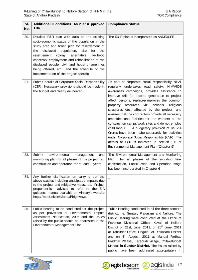
6-Laning of Chilakaluripet to Nellore Section of NH- 5 in the
State of Andhra Pradesh
EIA Report
TOR Compliance
1-7
Sl. No.
Additional C onditions As P er A pproved TOR
Compliance Status
30. Detailed R&R plan with data on the existing
socio-economic status of the population in the
study area and broad plan for resettlement of
the displaced population, site for the
resettlement colony, alternative livelihood
concerns/ employment and rehabilitation of the
displaced people, civil and housing amenities
being offered, etc and the schedule of the
implementation of the project specific
The R& R plan is incorporated as ANNEXURE
31. Submit details of Corporate Social Responsibility
(CSR). Necessary provisions should be made in
the budget and clearly delineated.
As part of corporate social responsibility NHAI
regularly undertakes road safety, HIV/AIDS
awareness campaigns, provides assistance to
improve skill for income generation to project
affect persons, replaces/improves the common
property resources viz. schools, religious
structures etc., affected by the project, and
ensures that the contractors provide all necessary
amenities and facilities for the workers at the
construction camps/work sites and do not employ
child labour. A budgetary provision of Rs. 2.4
Crores have been mabe separately for activities
under Corporate Social Responsibility (CSR). The
details of CSR is indicated in section 9.6 of
Environmental Management Plan (Chapter 9)
33. Submit environmental management and
monitoring plan for all phases of the project viz.
construction and operation for at least 5 years
The Environmental Management and Monitoring
Plan for all phases of the including Pre-
construction, Construction and Operation stage
has been incorporated in Chapter 6
34. Any further clarification on carrying out the above studies including anticipated impacts due
to the project and mitigative measures, Project
proponent is advised to refer to the EIA guidance manual available on Ministry’s website
http://moef.nic.in/Manual/highways.
_
35. Public hearing to be conducted for the project
as per provisions of Environmental Impact
Assessment Notification, 2006 and the issues raised by the public should be addressed in the
Environmental Management Plan.
Public Hearing conducted in all the three concern
district, i.e. Guntur, Prakasam and Nellore. The
Public Hearing were conducted at the Office of
Revenue Divisional Officer Kavali of Nellore
District on 21st, June, 2011, on 26th June, 2011
at Tahsildar Office, Ongole of Prakasam District
and on 4th August, 2011 at Mandal Parihad
Pradmik Patasal, Tatapudi village, Chilakaluripet
Mandal in Guntur District. The issues raised by
public have been addressed appropriately in

6-Laning of Chilakaluripet to Nellore Section of NH- 5 in the
State of Andhra Pradesh
EIA Report
TOR Compliance
1-8
Sl. No.
Additional C onditions As P er A pproved TOR
Compliance Status
Environmental Management Plan appropriately.
The Minutes of the Public Hearing Proceedings
and Response of NHAI is enclosed as APPENDIX-I
36. A detailed draft EIA/EMP report should be
prepared as per the above additional TOR and
should be submitted to the Ministry as per the
Notification.
The Draft EIA/EMP report has been prepared as
per Additional TOR.
6-Laning of Chilakaluripet to Nellore Section of NH- 5 EIA Report In the State of Andhra Pradesh Table of Contents
i
TABLE OF CONTENTS Contents Page No.
CHAPTER 1.0 INTRODUCTION ............................................................................................... 1-1 1.1 Purpose of the Report .......................................................................................................... 1-1
1.2 Identification of Project and Project Proponent ...................................................................... 1-1 1.3 Project Road ........................................................................................................................ 1-1
1.4 Environmental Screening of Project Road .............................................................................. 1-1 1.5 Objectives of the Study ........................................................................................................ 1-1
1.6 Scope of the Study ............................................................................................................... 1-2 1.7 Environmental Policies and Legislation ................................................................................... 1-2
1.8 Fly ash Notification ............................................................................................................... 1-5
1.9 Summary of Statutory Clearance Requirement ....................................................................... 1-6 1.10 Structure of the Report......................................................................................................... 1-7
CHAPTER 2.0 PROJECT DESCRIPTION ................................................................................... 2-1 2.1 Introduction......................................................................................................................... 2-1
2.2 Need for the project ............................................................................................................. 2-1 2.3 Project Objective .................................................................................................................. 2-2
2.4 Project Approach for Environmental Studies........................................................................... 2-2 2.5 Project Location ................................................................................................................... 2-2
2.5.1 Chilkaluripet to Nellore NH-5 ................................................................................................. 2-2
2.5.2 Proposed Bypass at Ongole .................................................................................................. 2-5 2.6 Proposed Development......................................................................................................... 2-5
2.7 Existing Scenario & proposed Plan for Project ........................................................................ 2-9 2.7.1 Chilkaluripet to Nellore NH-5 Section ..................................................................................... 2-9
2.7.2 Proposed Ongole Bypass section ........................................................................................... 2-9 2.7.3 Right of Way (ROW) .......................................................................................................... 2-10
2.7.4 Additional Land Requirement for Widening .......................................................................... 2-10
2.5.5 Traffic Scenario .................................................................................................................. 2-10 2.7.6 Pedestrian Flow ................................................................................................................. 2-12
2.7.7 Service Roads .................................................................................................................... 2-12 2.7.8 Vehicular/Pedestrian Underpasses ....................................................................................... 2-13
2.7.8 Cart Tracks ........................................................................................................................ 2-14
2.7.9 Bridges .............................................................................................................................. 2-15 2.7.10 Rail Over Bridge (ROB) ....................................................................................................... 2-15
2.7.11 Culverts ............................................................................................................................. 2-15 2.7.12 Toll Plazas ......................................................................................................................... 2-15
2.7.13 Facilities and Services to the Users ...................................................................................... 2-16 2.7.14 Traffic Sign and Pavement Marking ..................................................................................... 2-19
2.8 Typical Cross Section: ........................................................................................................ 2-19
CHPTER 3.0 DESCRIPTION OF ENVIRONMENT ...................................................................... 3-1 3.1 PHYSICAL ENVIRONMENT .................................................................................................... 3-1 3.1.1 PHYSIOGRAPHY ................................................................................................................... 3-1
3.1.2 GEOLOGY AND SEISMICITY .................................................................................................. 3-1
3.1.3 SOILS .................................................................................................................................. 3-2 3.1.4 QUARRY SITE AND BORROW AREAS:.................................................................................... 3-5
3.1.5 CLIMATIC CONDITIONS ....................................................................................................... 3-9 3.1.6 LAND USE PATTERN .......................................................................................................... 3-13
3.1.7 SURFACE WATER RESOURCE: ............................................................................................ 3-14
3.1.8 GROUNDWATER SOURCES ................................................................................................. 3-19 3.1.9 AMBIENT AIR QUALITY: ..................................................................................................... 3-21
3.1.10 AMBIENT NOISE LEVEL: ..................................................................................................... 3-24 3.2 ECOLOGICAL RESOURCES: ................................................................................................. 3-26
6-Laning of Chilakaluripet to Nellore Section of NH- 5 EIA Report In the State of Andhra Pradesh Table of Contents
ii
3.2.1 FOREST AREA .................................................................................................................... 3-26 3.2.2 ECOLOGICALLY PROTECTED AREA: .................................................................................... 3-28
3.2.3 ROADSIDE TREE PLANTATION: .......................................................................................... 3-28 3.2.4 FAUNA .............................................................................................................................. 3-29
3.3 SOCIAL ENVIRONMENT: ..................................................................................................... 3-29
3.3.1 DEMOGRAPHIC PROFILE .................................................................................................... 3-29 3.3.2 LITERACY .......................................................................................................................... 3-29
3.3.3 WORK PARTICIPATION ...................................................................................................... 3-30 3.3.4 OCCUPATION PROFILE ....................................................................................................... 3-30
3.3.5 HUMAN USE VALUES .......................................................................................................... 3-31
3.3.6 SETTLEMENTS ................................................................................................................... 3-31 3.3.7 MARKETS .......................................................................................................................... 3-31
3.3.8 CULTURAL PROPERTIES ..................................................................................................... 3-31
CHAPTER 4.0 ANTICIPATED ENVIRONMENTAL IMPACTS AND MITIGATION MEASURES ....................................................................................................... 4-1
4.0 Introduction......................................................................................................................... 4-1
4.1 IMPACTS DURING DESIGN/ PRE-CONSTRUCTIONAL PHASE ................................................... 4-2 4.1.1 Impact on Land Resources ................................................................................................... 4-2
4.1.2 Impact on People due to land acquisition and properties ........................................................ 4-3 4.1.3 Impacts on Other Assets ...................................................................................................... 4-5
4.1.4 Land use Change ................................................................................................................. 4-6
4.1.5 Impact on Water bodies: ...................................................................................................... 4-6 4.1.6 Religious, Common and Govt. Property Affected .................................................................... 4-7
4.1.7 Impact on Utilities ................................................................................................................ 4-8 4.1.8 Impact on Roadside Trees .................................................................................................... 4-8
4.1.9 Impact on Reserved Forest Land: ......................................................................................... 4-9
4.2 IMPACTS DURING CONSTRUCTION PHASE............................................................................ 4-9 4.2.1 Impact on Land Resources ................................................................................................. 4-10 4.2.2 Impact on Soil ................................................................................................................... 4-11 4.2.3 Impact on Water Resources ................................................................................................ 4-12
4.2.4 Impact on Water Quality: ................................................................................................... 4-14 4.2.5 Impact on Ambient Air Quality ............................................................................................ 4-14
4.2.6 Impacts on Noise Level ...................................................................................................... 4-16
4.2.7 Impact on Ecological Resources .......................................................................................... 4-18 4.2.8 Impact on Social Environment ............................................................................................ 4-18
4.2.9 Other Environmental Concerns of Construction Phase: ......................................................... 4-20 4.3 IMPACTS DURING OPERATIONAL PHASE ............................................................................ 4-22
4.3.1 Impacts on Water Quality and Resources ............................................................................ 4-22
4.3.2 Impact on Air Quality ......................................................................................................... 4-22 4.3.3 Impact on Noise Quality ..................................................................................................... 4-26
4.3.4 Human Use Values ............................................................................................................. 4-27 4.3.5 Road Safety ....................................................................................................................... 4-27
CHAPTER 5.0 ANALYSIS OF ALTERNATIVES ......................................................................... 5-1 5.1 Introduction......................................................................................................................... 5-1
5.2 “With” and “Without” Project Scenario ................................................................................... 5-1
CHAPTER 6.0 ENVIRONMENTAL MONITORING PROGRAMME ............................................... 6-1 6.1 Performance Indicators (PIS) ................................................................................................ 6-1
6.2 Selection of Indicators for Monitoring .................................................................................... 6-1
6.3 Monitoring of Performance Indicators .................................................................................... 6-2 6.3.1 Ambient Air Quality (AAQ) Monitoring ................................................................................... 6-2
6.3.2 Ambient Noise Monitoring ..................................................................................................... 6-2 6.3.3 Water Quality ...................................................................................................................... 6-2
6.3.4 Soil Quality .......................................................................................................................... 6-2

6-Laning of Chilakaluripet to Nellore Section of NH- 5 EIA Report In the State of Andhra Pradesh Table of Contents
iii
6.3.5 Tree Survival Rate ................................................................................................................ 6-2 6.4 Environmental Monitoring Action Plan ................................................................................... 6-3
6.5 Environmental Reporting System .......................................................................................... 6-3 6.6 ENVIRONMENTAL MONITORING COST .................................................................................. 6-3
CHAPTER 7.0 PUBLIC CONSULTATION ................................................................................. 7-1 7.1 Focus Group Discussion (FGD) .............................................................................................. 7-1
7.1.1 Need and Usefulness of Focus Group Discussion (FGD) .......................................................... 7-1 7.1.2 Objectives ........................................................................................................................... 7-1
7.1.3 Level of Discussion ............................................................................................................... 7-1
CHAPTER 8.0 PROJECT BENEFITS .......................................................................................... 8-1 8.1 Introduction......................................................................................................................... 8-1 8.2 Economic Development ........................................................................................................ 8-1
8.3 Employment Opportunity ...................................................................................................... 8-2
8.4 Road Safety ......................................................................................................................... 8-2 8.5 Reduction in Vehicle Operating Cost (VOC) ............................................................................ 8-3
8.6 Environmental Benefits ......................................................................................................... 8-3 8.7 Indirect Benefits .................................................................................................................. 8-4
CHAPTER 9.0 ENVIRONMENTAL MANAGEMENT PLAN (EMP) ................................................ 9-1 9.1 Objectives of the EMP .......................................................................................................... 9-1
9.2 Critical Environmental Issues ................................................................................................ 9-2 9.3 EMP Implementation Framework........................................................................................... 9-2
9.3.1 Key Players of EMP Implementation ...................................................................................... 9-2 9.3.2 Responsibilities and Authorities ............................................................................................. 9-2
9.3.3 Responsibilities of Concessionaire’s Chief Project Manager / General Manager
(CPM/GM) ........................................................................................................................... 9-3 9.3.4 Responsibilities of Concessionaire’s Project Manager (PM) ...................................................... 9-3
9.3.5 Responsibilities of Concessionaire’s Environmental / Safety Engineer ....................................... 9-3 9.3.6 Responsibilities of Contractor’s Project Manager ..................................................................... 9-3
9.3.7 Responsibilities of Contractor’s Environmental/ Safety Engineer (CEE/CSE) .............................. 9-4 9.4 Environmental Management Action Plan ................................................................................ 9-4
9.5 Environmental Training ........................................................................................................ 9-5
9.6 CORPORATE SOCIAL RESPONSIBILITY ............................................................................... 9-34 9.7 Environmental Budgeting .................................................................................................... 9-36
CHAPTER 10.0 ACCIDENTS AND ROAD SAFETY ................................................................... 10-1 10.1 GENERAL ........................................................................................................................... 10-1
10.2 SITE INSPECTION .............................................................................................................. 10-1 10.3 ACCIDENT DATA ................................................................................................................ 10-3
10.4 PROPOSED SAFETY FACILITIES .......................................................................................... 10-5 10.5 ADDRESSABLE OF SAFETY IN PROJECT DESIGN: ................................................................ 10-6
10.6 TRAFFIC MANAGEMENT DURING CONSTRUCTION STAGE: .................................................. 10-7 10.7 PREPARATION OF TRAFFIC MANAGEMENT PLAN ................................................................. 10-7
10.8 POST ACCIDENT EMERGENCY ASSISTANCE PLAN: ............................................................ 10-10
10.9 CONCLUSIONS ................................................................................................................. 10-10
CHAPTER-11 SUMMARY AND CONCLUSION ........................................................................ 11-1 11.1 The Project ........................................................................................................................ 11-1
11.2 Implementing Agency ........................................................................................................ 11-1
11.3 Project Location: ................................................................................................................ 11-1 11.4 Categorisation of Project: ................................................................................................... 11-1
11.5 Salient Features of Project .................................................................................................. 11-1 11.6 Description of the Environment ........................................................................................... 11-4
11.6.1 Physiography and Soil ........................................................................................................ 11-4

6-Laning of Chilakaluripet to Nellore Section of NH- 5 EIA Report In the State of Andhra Pradesh Table of Contents
iv
11.6.2 Climate .............................................................................................................................. 11-5 11.6.3 Ambient Air Quality ............................................................................................................ 11-5
11.6.4 Water Resources ................................................................................................................ 11-5 11.6.5 Noise Level ........................................................................................................................ 11-6
11.6.6 Forests .............................................................................................................................. 11-6
11.6.7 Road Side Plantation: ......................................................................................................... 11-6 11.6.8 Socio-economic Environment .............................................................................................. 11-6
11.6.9 Land Use Pattern ............................................................................................................... 11-7 11.6.10 Protected Monuments and Properties of Archaeological Value ............................................... 11-7
11.7 Anticipated environmental Impacts and Mitigation measures ................................................ 11-7
11.7.1 Impacts during Preconstruction Phase ................................................................................. 11-7 11.7.2 Impact during Construction and Operation Phase: ............................................................... 11-9
11.8 Environmental Monitoring Plan .......................................................................................... 11-17 11.9 Analysis of Alternatives ..................................................................................................... 11-17
11.10 Public Consultation ........................................................................................................... 11-17
11.11 Project benefits ................................................................................................................ 11-18 11.12 Environmental Management Plan ......................................................................................... 11-18
CHAPTER – 12 DISCLOSURES OF CONSULTANTS ENGAGED ............................................... 12-1 12.1 PREAMBLE ......................................................................................................................... 12-1 12.2 ENVIRONMENTAL IMPACT ASSESSMENT STUDY - CONSULTANCY FIRMS ............................. 12-1
12.3 TEAM OF CONSULTANTS .................................................................................................... 12-1
12.3.1 Dr. S. S. Deepak ................................................................................................................ 12-1 12.3.2 Mr. Nilesh Kumar ............................................................................................................... 12-1
12.3.3 Dr. Gagan C. Patra ............................................................................................................. 12-2 12.3.4 Dr. Sudesh Kaul ................................................................................................................... 12-2
12.3.4 Mr. Vishwanath Jangid ....................................................................................................... 12-2
12.3.5 Mr. K. Sudhendra Kumar .................................................................................................... 12-2 12.3.6 Mr. Vinay Kumar Rathi ....................................................................................................... 12-3 12.3.7 Mr. Mohan R. Zade ............................................................................................................ 12-3 12.3.8 Mr. Mohammed Rafiyuddin Shaphiyoddinn Malik .................................................................. 12-3
12.3.9 Monitoring Agency for Sampling and Analysis of Air, Water, Noise data and Meteorological data: ........................................................................................................... 12-3

6-Laning of Chilakaluripet to Nellore Section of NH- 5 EIA Report In the State of Andhra Pradesh Table of Contents
v
List of Tables
Table 2.1: Salient Features of the Project .......................................................................................... 2-6 Table 2.2: Chainage Details .............................................................................................................. 2-9
Table 2.3: Average Daily Traffic at Traffic Homogeneous Sections .................................................... 2-10
Table 2.4: Proposed Traffic Growth Rate (%) for Different types of Vehicles ...................................... 2-11 Table 2.5: Projected Traffic at the Homogeneous Traffic Sections ..................................................... 2-11
Table 2.6: Pedestrian Flows across Highway .................................................................................... 2-12 Table 2.7: Proposed Vehicular Underpasses and Pedestrian/Cattle Underpasses ................................ 2-13
Table 2.8: Cart Tracks for Ongole Bypass ........................................................................................ 2-14
Table 2.9: Existing Toll Plazas ......................................................................................................... 2-15 Table 2.10: Proposed Toll Plaza Locations ....................................................................................... 2-16
Table 2.11: Truck Lay-Bys cum Rest Area ........................................................................................ 2-16 Table 2.12: Proposed Wayside Amenity locations ............................................................................. 2-17
Table 2.13: Proposed Locations of Street lighting ............................................................................. 2-17
Table 2.14: Proposed Locations of Highway Lighting ........................................................................ 2-18 Table 2.15: Proposed Locations of Pedestrian Guard Railing ............................................................. 2-18
Table 3.1: Soil Sampling Location Along The Project Road .................................................................. 3-2 Table 3.2: Physico-Chemical Characteristics Of Soil Along The Project Corridor .................................... 3-3
Table 3.3: The Month Wise Average Temperature And Rainfall For Last 10 Years (From 2000 To 2010) ................................................................................................................ 3-9
Table 3.4: Land Use Pattern In Guntur, Prakasam And Nellore Districts ............................................. 3-13
Table 3.5: River And Canals Crossing The Project Section ................................................................. 3-14 Table 3.6: Ponds / Tanks Within Corridor Of Impact Project Road ..................................................... 3-15
Table 3.7: Surface Water Sampling Location .................................................................................... 3-16 Table 3.8: Surface Water Quality Results ......................................................................................... 3-18
Table 3.9: Ground Water Sampling Locations ................................................................................... 3-19
Table 3.10: Ground Water Quality Results ....................................................................................... 3-20 Table 3.11: Sampling Locations Of Ambient Air Quality Along The Project Corridor ............................ 3-21
Table 3.12: Ambient Air Quality Along Chilakluripet To Nellore Section Nh-5 At Different Locations ...................................................................................................................... 3-22
Table 3.13: Noise Monitoring Locations Along The Project Road ........................................................ 3-24 Table 3.14: Ambient Noise Level At Different Location Along Project Corridor .................................... 3-26
Table 3.15: District-Wise Forest Coverage (In Sq Km) (Source Andhra Pradesh Forest
Statistics, 2007) ............................................................................................................ 3-27 Table 3.16: Reserve Forest Within Corridor Of Impact ...................................................................... 3-27
Table 3.17: Tree Species Along Roadside ........................................................................................ 3-28 Table 3.19: Demographic Profile Of Guntur, Prakasam And Nellore Districts ...................................... 3-29
Table 3.20: Literacy Of Guntur, Prakasam And Nellore Districts ......................................................... 3-30
Table 3.21: Proportion Of Workers And Non Workers In Guntur, Prakasam And Nellore Districts ........................................................................................................................ 3-30
Table 3.22: Occupation Profile Of Guntur, Prakasam And Nellore Districts ......................................... 3-30 Table 3.23: Religious Features Along The Project Corridor ................................................................ 3-31
Table 4.1: Districwise Additional Land Requirement for Proposed Project ............................................ 4-3 Table 4.2: Ownership status of the Affected Structures ...................................................................... 4-3
Table 4.3: Usage of the private properties affected ............................................................................ 4-4
Table 4.4: Type and Area of Structures Affected along project ............................................................ 4-4 Table 4.5: Usage of the displaced structures ...................................................................................... 4-4
Table 4.6: Other assets and minor structures affected ........................................................................ 4-5 Table 4.7: List of affected Water Tanks due to Proposed Widening ..................................................... 4-6
Table 4.8: Religious Structures within the Proposed ROW ................................................................... 4-7
Table 4.10: Water Requirement for Construction.............................................................................. 4-13 Table 4.11: Typical Noise Levels of Principal Construction Equipment during major
construction activity (Noise Level in dB (A) at 50 Feet) .................................................... 4-16 Table 4.12: Land use, Emission Standards and the Road Width ........................................................ 4-23

6-Laning of Chilakaluripet to Nellore Section of NH- 5 EIA Report In the State of Andhra Pradesh Table of Contents
vi
Table 4.13: Predicted 1-Hour Average CO Concentrations for the Years 2011, 2015, 2020, 2025, and 2030 .................................................................................................... 4-25
Table 4.14: Predicted Ambient Noise Levels at Receptors ................................................................ 4-27 Table 5.1: ‘With’ and ‘Without’ Project Scenario ................................................................................. 5-1
Table 6.1: Environmental Monitoring Plan .......................................................................................... 6-4
Table 7.1: Outputs of local level consultations ................................................................................... 7-2 Table 9.1: Critical Environmental Issues to be addressed .................................................................... 9-2
Table 9.2 Environmental Management Plan ....................................................................................... 9-6 Table 9.3: Environmental Mitigation and Monitoring Cost.................................................................. 9-37
Table 11.1: Salient Features of the Project ...................................................................................... 11-2
Table 11.2: Anticipated Environmental Impacts due to the Proposed Project and their Mitigation Measures during Pre-construction Stage: ......................................................... 11-7
Table 11.3: Matrix of Potential Environmental Impacts and Mitigation Measures during Construction and Operation Stage ................................................................................ 11-10
List of Figures Figure 2.1: Index Map Project Road .................................................................................................. 2-3
Figure 2.2: Location Plan of Chilakaruripet-Nellore Section of NH-5 ..................................................... 2-4 Figure 2.3: Location of Proposed Ongole By-Pass .............................................................................. 2-5
Figure 2.4 a: Typical Cross Section .................................................................................................. 2-21
Figure 2.4 b: Typical Cross Section .................................................................................................. 2-22 Figure 2.4 c: Typical Cross Section .................................................................................................. 2-23
Figure 2.4d: Typical Cross Section in Reserved Forest Section .......................................................... 2-24 Figure 2.4e: Typical Cross Section in Reserved Forest Section ........................................................... 2-25
Figure 3.1: Location Plan Of Soil Samples Along Project Corridor ........................................................ 3-4
Figure 3.2a: Identified Potential Quarry Sites For The Project ............................................................. 3-6 Figure 3.2b: Identified Potential Quarry Sites For The Project ............................................................. 3-7
Figure 3.2c: Identified Potential Quarry Sites For The Project ............................................................. 3-8 Figure 3.3: Variation In Annual Rainfall At Different Places Along Project Area During Last
10 Years ...................................................................................................................... 3-10 Figure 3.4: Wind Rose Diagram At Ongole ....................................................................................... 3-12
Figure 3.5: Land Use Pattern Along Project Alignment ...................................................................... 3-14
Figure: 3.6 Surface And Ground Water Sampling Locations ............................................................... 3-17 Figure 3.7: Sampling Location Of Ambient Air Quality ....................................................................... 3-23
Figure 3.8: Noise Monitoring Locations Along The Project Road ........................................................ 3-25 Figure 3.9: Forest Coverage In Andhra Pradesh ............................................................................... 3-27

6-Laning of Chilakaluripet to Nellore Section of NH- 5 in the
State of Andhra Pradesh
EIA Report
Introduction
1-1
CHAPTER 1.0
INTRODUCTION
1.1 Purpose of the Report
The environment has a limited carrying capacity and it can only sustain a negative impact up to a
level without further degradation. Several systems, however, temporarily disturb it leading to a
new balance in order to re-establish the equilibrium between human activity and nature. But
sensitive systems are not so resilient to cope up with changes in physical and natural
Environment, thus not only leading to negative impact on them but also, socio-economic losses
may occur. Road projects are meant for improving the quality of life for people and developing the
country’s economy. For all positive impacts of the road projects, there may be also some
significant detrimental impacts on nearby communities and natural environment. There may be
impact on properties of people, their livelihood and other social components. Similarly there can
be direct or indirect impact on flora, fauna, water resources, land use etc. To account for all these
issues, environmental and social impact assessment is utmost necessary. These concerns for
environmental and social issues in road projects have also become a part of legal requirements
and for obtaining financial support. Environmental considerations are therefore of prime
importance in road projects.
1.2 Identification of Project and Project Proponent
The National Highways Authority of India (NHAI) has been entrusted with the development,
maintenance and management of the National Highways as entrusted to it by the Government of
India. Under NHDP Phase-V Programme, the Government of India has decided to convert this
existing four-lane highway section of National Highway No.-5 (NH-5) from Chilakaluripet to Nellore
section into six-lane highway. This project is to be executed by private entrepreneurs on DBFO
pattern.
This report pertains to environmental aspects of consultancy related to feasibility study for the
improvement of selected four lane section to six lane section of National Highway No.-5 from
Chilakaluripet to Nellore in the State of Andhra Pradesh. The Project Proponent is National
Highway Authority of India.
1.3 Project Road
This project section of NH-5 starts at Km 1182+802 at Tatapudi village near Chilakaluripet in the
district of Guntur and ends at Km 1366+547 after passes through the Districts of Guntur,
Prakasam and Nellore. The entire project road falls in the State of Andhra Pradesh.
1.4 Environmental Screening of Project Road
The environmental assessment preparation led to identification of potential environmental hazards
and their feasible remedial measures, based on which the environmental mitigation measures
have been prepared.
1.5 Objectives of the Study
The major objective of this study is to establish present environmental condition along the project
corridor through available data / information supported by field studies to evaluate the impacts on
relevant environmental attributes due to the construction & operation of the proposed project; to
recommend adequate mitigation measures to minimize / reduce adverse impacts and to prepare

6-Laning of Chilakaluripet to Nellore Section of NH- 5 in the
State of Andhra Pradesh
EIA Report
Introduction
1-2
an Environmental Management Plan (EMP) for timely implementation of the mitigation measures
to make the project environmentally sound and sustainable. An Environmental Impact Assessment
(EIA) study basically includes:
• Establishment of the present environmental scenario
• Study of the specific activities related to the project
• Evaluation of the probable environmental impacts
• Recommendations of necessary environmental control measures.
• Preparation of Environmental Management Plan
1.6 Scope of the Study
Environmental assessment is a detailed process, which starts from the conception of the project
and continues till the operation phase. The steps for environmental assessment are therefore
different at different phases. The present report details the environmental setting of the project
zone, collects the baseline data and then identifies the anticipated environmental impact and
finally suggests appropriate mitigation measures and mechanism for ensuring effective
implementation of the environmental safeguard measures at different stages of the project..
1.7 Environmental Policies and Legislation
Table-1.1 presents Environmental regulations and legislations relevant to this project, which are
the responsibility of a number of government agencies.
Table 1.1: Summary of Relevant Environmental Legislations
Act/Rule/Notification/ Policy
Year Objectives Responsible Agency
The Environment (Protection)
Act The Environment (Protection)
Rules
1986
1986
To protect and improve the overall
environment
MoEF; GoI; Department
of Forest, GoAP; CPCB; APPCB
Environment Impact Assessment Notification and amendments
made thereafter.
2006 To provide environmental clearance to new development activities following
environmental impact assessment
MoEF; GoI; CPCB; APPCB
Indian Forest Act
Forest (Conservation) Act
Forest (Conservation) Rules
Forest Conservation Rules (Notification)
1927
1980
1981
2003
To consolidate the laws related to forest, the transit of forest produce and
the duty livable on timber and other
forest produce. Conservation of Forests, Judicious use
of forestland for non-forestry purposes; and to replenish the loss of forest cover
by Compensatory Afforestation on degraded forestland and non-forest
land.
Procedure for submission of the proposals seeking approval for Central
Government for diversion of forestland to non-forest purposes.
MoEF; Department of Forest, GoAP
Wild Life (Protection) Act
The Wild Life (Protection)
Amendment Act
1972
2002
To protect wildlife in general and
National Parks and Sanctuaries in particulars.
To protect wild animals, birds and plants with a view to ensure the
ecological and environmental security
of the country.
Chief Conservator of
Wildlife, Wildlife Wing, Forest Department,
GoAP National/State Board for
Wildlife
National Forest Policy 1952 To maintain ecological stability through Forest Department, GoI

6-Laning of Chilakaluripet to Nellore Section of NH- 5 in the
State of Andhra Pradesh
EIA Report
Introduction
1-3
Act/Rule/Notification/ Policy
Year Objectives Responsible Agency
National Forest Policy (Revised) 1988 preservation and restoration of
biological diversity
and GoAP
The Water (Prevention and
Control of Pollution) Act
1974 To control water pollution by
controlling discharge of pollutants as per prescribed standards
CPCB; APPCB
The Air (Prevention and Control
of Pollution) Act
1981 To control air pollution by controlling
emission of air pollutants as per prescribed standards
CPCB; APPCB &
Transport Department; GoUP
Noise Pollution (Regulation and
Control) Rules The Noise Pollution (Regulation
and Control) Amendment Rules
2000
2006
To regulate and control noise
producing and generating sources with the objective of maintaining the
ambient air quality standards in respect of noise.
CPCB; APPCB &
Transport Department; GoAP
The Motor Vehicle Act
Central Motor Vehicle Rules
1988
1989
To consolidate and amend the laws related to motor vehicles.
Licensing of driving of motor vehicles, registration of motor vehicles, with
emphasis on road safety standards and
pollution control measures, standards for transportation of hazardous and
explosive materials To check vehicular air and noise
pollution.
RTO Office, GoAP
The Ancient Monuments and Archaeological Sites and Remain
Act
1958 To provide for the preservation of ancient and historical monuments and
archeological sites and remains of national importance and protection
sculptures, carvings and other like
objects.
Archaeological Department, GoI; Indian
Heritage Society and Indian National Trust for
Art and Culture Heritage
(INTACH),
The National Highway Act 1956 For Land Acquisition NHAI; Revenue
Department, GoAP
National Policy of Resettlement and Rehabilitation
2007 For payment of compensation and assistance, different entitlements
payment of compensation and assistance, resettlement and
rehabilitation of project affected
population due to acquisition of lands and structures.
PIU NHAI, Competent Authority (Revenue
Department)
Andhra Pradesh Water, Land and
Trees Act
2002
(WALTA Act)
Andhra Pradesh Water, Land and Trees
Act 2002 is a comprehensive law enacted by the GOAP and it is a unique
initiative in the country.
District Authority
APWALTA promotes water conservation
and tree cover; regulates the
exploitation and use of ground and surface water. The objective is
protection and conservation of land, water sources and environment and
matters connected therewith or incidental thereto.
A brief description of relevant laws is given below:
Forest (Conservation) Act, 1980: The Forest (Conservation) Act, 1980 is of particular significance in
case the project corridors require acquisition of forestland outside the RoW of the road corridors as a
result of the rehabilitation work proposed.

6-Laning of Chilakaluripet to Nellore Section of NH- 5 in the
State of Andhra Pradesh
EIA Report
Introduction
1-4
If the area of forest land to be cleared or diverted exceeds 20 ha., then prior permission of Central
Government is required;
In case of Reserved Forest
If the forest land is between 5 to 20 ha., then permission form the Regional Office of Chief Conservator is
required;
If the forest land is below or equal to 5 ha., the State Government can give permission; and,
If the canopy area is more than 40% forest, permission to undertake any work is needed from the Central
Government, irrespective of the size of the area.
MoEF regional office is empowered to accord Forest Clearance for an area up to 5 ha.
In case of Protected Forest
Wild Life Protection Act, 1972 has allowed the government to establish a number of National Parks and
Sanctuaries over the past 25 years, to protect and conserve the flora and fauna of the State.
The Water (Prevention and Control of Pollution) Act, 1974 resulted in the establishment of the Central and
State level Pollution Control Boards whose responsibilities include managing water quality and effluent
standards, as well as monitoring water quality, prosecuting offenders and issuing licenses for construction
and operation of any facility. This will include generation of liquid effluent during construction of road from
Civil Engineering activities or from domestic activities in workers colony. There are specific penalties for
violation, which include imprisonment for responsible officials.
The Air (Prevention and Control of Pollution) Act, 1981 empowers Central and State Pollution Control
Boards for managing air quality and emission standards, as well as monitoring air quality, prosecuting
offenders and issuing licenses for construction and operation of any facility. There are specific penalties for
violation, which include imprisonment for responsible officials. This Act has notified National Ambient Air
Quality Standard for different regions e.g. Industrial, Residential and Sensitive. Air quality during
construction and operation phases will be guided by this specific act.
Environment (Protection) Act, 1986: This Act was passed as an overall comprehensive act “for protection
and improvement of environment”. According to this Act, the Central Government has the power to take
all such measures as it deems necessary or expedient for the purpose of protecting and improving the
quality of environment and preventing, controlling and abating environmental pollution. Under this act
rules have been specified for discharge/emission of effluents and different standards for environmental
quality. These include Ambient Noise Standard, Emission from Motor Vehicles, Mass Emission Standard for
Petrol Driven Vehicles, General Effluent Standards etc. especially important for road project.
EIA Notification, 2006: The Environment Impact Assessment (EIA) notification 2006, Ministry of
Environment and Forests, Government of India, came into effect from 14th
Category A: New National Highways and expansion of existing National Highway greater than 30 Km,
involving additional RoW greater than 20 m involving land acquisition and passing through more than one
state.
September 2006. The EIA
Notification, 2006 specifies the various development projects requiring prior clearance from Ministry of
Environment and Forests (MoEF). As per Schedule of the Notification; the Highway project falls under
Physical Infrastructure including Environmental Services and have been listed under item no. 7(f),
including new highways or expansion of existing highways. The projects and activities under the
Notification have been classified into two categories- Category A and Category B, based on the spatial
extent of potential impacts on human health and natural and man made resources. The highway projects
have also been classified into two categories- Category A and Category B based on the following
conditions:

6-Laning of Chilakaluripet to Nellore Section of NH- 5 in the
State of Andhra Pradesh
EIA Report
Introduction
1-5
Category B: All State Highway projects and State Highway expansion projects in hilly terrain (above 1000
m AMSL) and or ecologically sensitive areas.
Moreover any project or activity specified in Category B will be treated as Category A if located in whole or
in part with in 10 km from the boundary of:
i. Protected areas notified under the Wild Life (Protection) Act, 1972,
ii. Critically Polluted areas as notified by Central Pollution Control Board from time to time,
iii. Eco sensitive areas as notified under section 3 of Environment Protection Act, 1986 such as
Mahabaleshwar, Panchangi, Matheran, Pachmarhi, Dahanu, Doon Valley and
iv. Inter State boundaries and international boundaries.
Provided that the requirement regarding distance of 10 km of the inter-state boundaries can be reduced or
completely done away with by an agreement between the respective States or U.Ts sharing the common
boundary in the case the activity does not fall within 10 kilometers of the areas mentioned at item (i), (ii)
and (iii) above
In the present case, the proposed highway is more than 30 Kms in length. At several locations (entry and
exit points; rest areas and at toll plaza) the land acquisitions is more than 20 m. Hence, as per EIA
notification 2006, the proposed project falls under Category A and attracts the conditions of obtaining prior
Environmental Clearance from Ministry of Environment and Forests (MoEF).
1.8 Fly ash Notification
According to the Notification No. S.O. 763(E), dated 14.09.1999 and its amendment thereafter on
27.08.2003 and notification S.O. 2804(E) dated 3rd
Soil required for top or side cover of embankment of roads or flyovers shall be excavated from the
embankment site and it is not possible to do so, only the minimum quantity of the soil required for the
purpose shall be excavated from soil borrow area. In either case, the topsoil should be kept or stored
separately. Voids created due to soil borrow area shall be filled up with ash with proper compaction and
covered with top soil kept separately as mentioned above.
November 2009 by Ministry of Environment and
Forests, it is mandatory to use fly ash with in a radius of 100 kilometers of Thermal Power Plant. No
agency, person or organization shall within a radius of 100 kilometer of Thermal Power Plant undertake
construction or approve design for construction of roads of flyover embankments in contravention of the
guidelines/ specification issued by the Indian Road Congress (IRC) as contained in IRC specification No.
SP: 56 of 2001. Any deviation from this direction can only be agreed to an technical reasons if the same is
approved by Chief Engineer (Design) or Engineer-in-chief of the concerned agency or organization or on
production of certificate of “Pond ash not available” from the Thermal Power Plant(s) located within 100
kilometers of the site construction. This certificate shall be provided by TPP within two working days from
the date of making request for fly ash.
No agency, person or organization shall within a radius of 100 kilometers of coal or lignite based Thermal
Power Plant allow reclamation and compaction of low lying areas with soil. Only pond ash shall be used for
compaction. They shall also ensure that such reclamation and compaction is done in accordance with the
bye-laws, regulation and specification laid down by Authorities.
All agencies undertaking construction of roads or fly over bridges including Ministry of Shipping Road
Transport and Highways (MoSRTH), National Highways Authority of India (NHAI), Central Public Works
Department (CPWD), State Public Works Department and other State Government Agencies, shall within
three months from the 1st day of September 2003 make provision in their documents, schedules of
approved materials and rates as well as technical documents; including those related to soil borrow area
or pits.

6-Laning of Chilakaluripet to Nellore Section of NH- 5 in the
State of Andhra Pradesh
EIA Report
Introduction
1-6
Make necessary specifications/guidelines for road or fly over embankments that are not covered by the
specification laid down by the Indian Road Congress (IRC).
Three coal based thermal Power plants Namely Nellore Thermal Power Plant, Kovur and Sitapuram Power
Plant at Dondapadu and Dr Narla Tata Rao Thermal Power Plant, Vijaywada fall within a radius of 100
kilometer from the proposed alignment of Nellore-Chilakaluripet section of NH-5; hence the fly ash
utilization in the part of the project road is mandatory, subject to availability. In case the fly ash is used in
the project, all the above mentioned provision shall be enforceable.
1.9 Summary of Statutory Clearance Requirement
The project requires a number of statutory clearances under different Acts and Rules at different stage of
the project. These are listed in Table 1.2.
Table 1.2: Summary of Statutory Clearance Requirement of the Project Sl. No
Type of Clearance Applicability Project Stage Responsibility
1. Environmental Clearance For Prior Environmental
Clearance for Highway Project
Pre-Construction PIU, NHAI
2. Forest Clearance for land
diversion
For acquisition of
Reserve forest land
Pre Construction PIU-NHAI
3. Tree felling permission under WALTA Act
For roadside tree cutting
Pre construction PIU-NHAI
4. NOC and consents under Air & Water Act from SPCB
For Highway Project Alignment
Pre- Construction PIU-NHAI
5. Consent for Establishment
under Air and Water Act from SPCB
For siting and
erection of stone crusher and Hot
Max Plants etc.
Construction Stage (Prior
to erection of Plants)
The
Concessionaire
6. Consent for Operation under Ai and Water Act
from SPCB
For operating construction plant,
crusher, batching plant, Hot Max Plant
etc.
Construction Stage (Prior to commencement of
Operation of Plants)
The Concessionaire
7. Explosive License from Chief Controller of
Explosives,
For storing fuel oil, lubricants, diesel etc.
Construction stage (Prior to storing fuel, lubricants
and Diesel, etc.)
The Concessionaire
8. Permission for storage of hazardous chemical from
CPCB
Manufacture storage and Import of
Hazardous Chemical
Construction stage (Prior to initiation of any work)
The Concessionaire
9. Quarry Lease Deed and Quarry License from State
Department of Mines and Geology
Quarry operation Construction stage (Prior to initiation of Quarrying)
The Concessionaire
10. Permission for extraction of
ground water for use in road construction activities
from State Ground Water board
Extraction of ground
water
Construction stage (Prior
to initiation of installation of Bore wells and
abstraction of water from such source)
The
Concessionaire
11. Permission for use of water
for construction purpose from irrigation department
Use of surface water
for construction
Construction stage (Prior
to initiation of abstraction of water from such
source)
The
Concessionaire
12. Labour license from Labour Commissioner Office
Engagement of Labour
Construction stage (Prior to initiation of any work)
The Concessionaire

6-Laning of Chilakaluripet to Nellore Section of NH- 5 in the
State of Andhra Pradesh
EIA Report
Introduction
1-7
1.10 Structure of the Report
The present Environmental Impact Assessment Report is structured in accordance with the generic
structure as prescribed under Environment Impact Assessment Notification, 2006, Ministry of
Environment and Forests (MoEF) and the content is briefed below:
Chapter 1.0 Introduction: The chapter provides the introduction to the present project, identification of
the project proponent, need of the project and its interventions with statutory requirements.
Chapter 2.0 Project Description: It provides the details of salient features of the existing project road,
details of the proposed developments – widening proposal, service roads, details of bridges,
culverts, flyover, vehicular/ pedestrian underpasses, bus bays, truck lay byes, entry and exit
locations, rest areas and toll plaza etc.
Chapter 3.0 Analysis of Alternatives: This chapter provides detailed analysis of alternatives that has
been carried out ‘with project’ or ‘without project’ scenario in terms of potential environmental
impacts.
Chapter 4.0 Description of the Environment: The chapter describes Baseline Environmental features
within the project area in details. It includes detailing of physical environmental resources viz.
(Physiography, Geology and Soils, Quarry Site and Borrow Area, Climatology details), Ecological
and social & cultural resources along the project road corridor and its area of influence. The
data presented in the chapter is collected from primary and secondary sources.
Chapter 5.0 Anticipated Environmental Impacts & Mitigation Measures: It deals with details of
anticipated environmental impacts (both positive as well as negative) due to the proposed
project and provides mitigation measures for all the identified adverse impacts during design
and construction phase and operation stage of the project.
Chapter 6.0 Environmental Monitoring Programme: The chapter provides the details about the
Environmental Monitoring Plan in Construction Stage and in Operation Stage. The monitoring
plans details out the performance indicators, monitoring parameters, standards, frequency,
duration, implementation and responsibilities required for monitoring and the cost of monitoring
the parameters.
Chapter 7.0 Public Consultation: Provides details about the project related additional studies carried
out for the project. The details of Focus Group Discussions carried out and the responses
received from the people are presented in this chapter.
Chapter 8.0 Project Benefits: This chapter describes Project Benefits from proposed project and
includes local benefits and the wider regional or national level benefits.
Chapter 9.0 Environmental Management Plan (EMP): This chapter comprises a set of environmental
safeguard measures for identifies adverse impacts during different stage of the project and
activities with an objective to offset or reduce adverse environmental impacts to acceptable
levels. The EMP provides action plan of implementation of mitigation measures at different
locations, time frame with responsibility assignments for implementing appropriate measures at
appropriate time for ensuring effectiveness of the proposed safeguard measures. Adequate
budgetary provisions have also been made for implementation and monitoring of the
effectiveness of the suggested measures.
Chapter 10.0 Summary and Conclusion: This chapter summarises the finding of the EIA study.
Chapter 11.0 Accidents and Road Safety: This Chapter examines the existing scenario of the road
safety and proposed safety aspects into the project. The Chapter also describes the Post
Accident Emergency Assistance Plan.
Chapter 12.0 Disclosure of the Consultants Involved: This chapter gives the details of consultants
involved in reviewing and preparing of the report.

6-Laning of Chilakaluripet to Nellore Section of NH- 5 in the State of Andhra Pradesh
EIA ReportProject Description
2-1
CHAPTER 2.0
PROJECT DESCRIPTION
2.1 Introduction
National Highway No.5 (called as “NH No. 16” vide notification S.O. 542(E) published on 05-03-
2010 in Part II, Section 3, Sub-section (ii) in the Gazette of India, Extraordinary) is a part of
golden quadrilateral project and is the significant link between Kolkata and Chennai. It traverses
Wast Bengal, Orissa, Andhra Pradesh and Tamilnadu and connects number of major urban areas
on its way viz. Kolkotta, It takes off from Baharagora (near Kolkata) and terminates at Chennai in
the state of Tamilnadu after passing through major towns Bhrampur, Bhubaneshwar, Cuttack,
Bhadrak, Palsa-Kasibugga of Orissa, Tekkali, Srikakulam, Vishakhapattanam, Rajmundary, Eluru,
Vijayawada, Guntur, Chilakaluripet, Ongole, Nellore in Andhra Pradesh and Chennai, the capital
city of Tamilnadu. The Government of India has resolute to promotion 6500 km span of
accessible 4-lane alienated highways into Six-Lane divided carriageway under Phase-V of
National Highway Development project (NHDP). The Phase-V of NHDP is to be executed as BOT
(Toll) Project through Public Private Partnership (PPP) on Design-Build-Finance-Operate (DBFO)
model.
The present project includes widening and up-gradation of the section of NH-5 from Km
1182+802 (at Tatapudi village of Chilakaluripet Mandal in Guntur District) to Km 1366+547 (at
Kovour villange of Kovur Mandal in SPSR Nellore District) from existing 4 lane to 6-lane
configuration, covering a distance of 183.745 Km (old) and a new six lane Ongole bypass having
a length of 10.125 Km. Its length along new ongole bypass is about 183.620km.
The National Highway Authority of India (NHAI) has selected BCEOM Societe Francaise
d’Ingenierie, France in Association with BCEOM India Pvt. Limited, at present known as EGIS
India Consulting Engineers Pvt Ltd., as consultants to bring out probability study for upgrading
the accessible four lane highway to Six-Lane access control highway (retrofitting on the exiting
alignment) from Nellore to Chilakaluripet a section of NH-5. The Consultant have completed the
study and submitted the final feasibility report vide letter BCEOM/2008/6184 dated 22 July 2008.
Subsequently consultants were instructed to carryout feasibility study for providing bypasses for
Ongole towns and a letter to this effect (Ref: NHAI/NHDP-V/BOT (Toll)/BP/2009/65 dated
14.12.09) has been issued to the Consultants by NHAI to initiate the studies as an additional
work. The proposed bypass was planned from Mukthinuthalapadu (1241+450) to Pelluru
(1251+700) will connect NH-5 without disturbing of local human lives, vegetation and
economics.
2.2 Need for the project
Road projects are generally undertaken to improve the economic and social welfare of those
using the road or served by it. Increased road capacity and improved pavements can reduce
travel times and lower the costs of vehicle use. Benefits include increased access to markets,
jobs, education and health services, and reduced transport costs for both freight and passengers,
reduce fuel consumption and exhaust emissions from the vehicle plying on the road.

6-Laning of Chilakaluripet to Nellore Section of NH- 5 in the State of Andhra Pradesh
EIA ReportProject Description
2-2
2.3 Project Objective
The main objective of the project is to prepare a proposal to retrofit a six-lane cross-section on
to the existing 4-lane highway in a manner which ensures:
Enhanced safety of the traffic, the road users and the people living close to the highway.
Enhanced operational efficiency of the highway.
Fulfilment of the access needs of the local population.
Minimal adverse impact on the road users and the local population due to construction.
Feasible and constructible options for the project with least cost options.
This Detailed Feasibility study will be used as a planning tool for integrating objectives of
sustainable development with economic growth and social development to facilitate
decision-making.
2.4 Project Approach for Environmental Studies
The basic approach adopted for conducting the environmental study for the project will strongly
pursue the prevailing institutional and legislative setup of the Government of India (GoI) and in
conformity with NHAI policy on this subject. The main approaches are:
Identification, appraisal and division between positive and negative impacts, direct and
indirect impacts, and instant and long-term impacts likely to result from the proposed
bypass;
Identification of unavoidable or irreversible impacts;
Explanation of the impacts quantitatively, in terms of environmental costs and benefits, if
possible;
Characterization of the extent and quality of available data;
Identification of significant information deficiencies;
Identification as well as estimation of any uncertainties associated with predictions of
impacts;
Identification of un-mitigated negative impacts;
Exploration towards the opportunities for environmental enhancement; and
Identification of feasible and cost effective mitigation measures to minimize negative
impacts and enhance positive impacts by incorporating in the preliminary engineering
design.
2.5 Project Location
2.5.1 Chilkaluripet to Nellore NH-5
The project highway (183.7 Km) section of NH-5 from Chilkaluripet to Nellore is a part of golden
quadrilateral project in the state of Andhra Pradesh which connects capital of West Bengal,
Kolkota to Capital of Tamil Nadu Chennai. The existing 4 lane road has been upgraded from old 2
Lane roads over the last five years under three construction packages AP-13, AP-12 & AP-11. It
passes through Guntur, Prakasam and Nellore districts of the Andhra Pradesh. The project
highway location in India and in the state of Andhra Pradesh is presented in the Figure 2.1 and
Figure 2.2.

6-Laning of Chilakaluripet to Nellore Section of NH- 5 in the State of Andhra Pradesh
EIA ReportProject Description
2-3
Figure 2.1: Index Map Project Road
Project Road
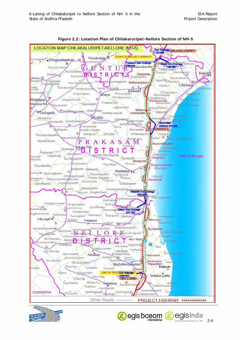
6-Laning of Chilakaluripet to Nellore Section of NH- 5 in the State of Andhra Pradesh
EIA ReportProject Description
2-4
Figure 2.2: Location Plan of Chilakaruripet-Nellore Section of NH-5

6-Laning of Chilakaluripet to Nellore Section of NH- 5 in the State of Andhra Pradesh
EIA ReportProject Description
2-5
2.5.2 Proposed Bypass at Ongole
The proposed bypass road corridor starts from village Mukthinuthalapadu (NH-5, Ch. 1241+450)
and ends at village Pelluru (NH-5, Ch.1251+700) near to Ongole town of Prakasam district. The
proposed bypass road section passes through grass land, agriculture land, bushes land. It will
also cross two canals and FCR Road at near NTR Colony and also cross twice the railway track
to reach village Pelluru at change 1251+700 of NH-5. The total length of proposed bypass is
10.125 km. The project new bypass road section passes through coastal area of Prakasam
district, Andhra Pradesh. The proposed bypass location is presented in the Figure 2.3.
Figure 2.3: Location of Proposed Ongole By-Pass
2.6 Proposed Development
As stated earlier the proposed project is the part of National Highway Development project
(NHDP) Phase-V and is to be developed to 6-lane configuration. The project will be executed by
National Highways Authority of India (NHAI) as Public Private Partnership (PPP) ventures on
DBFO (Design-Built-Finance-Operation) pattern. The project road under the proposal is from Km
1182+802 at Tatapudi village to Km 1366+547 at Kovur Village in the State of Andhra Pradesh.
Under this project it is proposed to widen and upgrade the section from 4-lane to 6-lane
standards along with provisions of additional facilities and services including enhancement of
highway safety. The salient features of the proposed project is summarised in Table 2.1.

6-Laning of Chilakaluripet to Nellore Section of NH- 5 in the State of Andhra Pradesh
EIA ReportProject Description
2-6
Table 2.1: Salient Features of the Project Sl. No
Project Components
Details
A. General Information
1. Location of Project From Tatapudi village of Chilakaluripet Mandal in Guntur District
(Km1182+802) to Kovur Village of Kovur Mandal in SPSR Nellore District
(Km1366+547) a section of NH-5 including proposed Ongole bypass
from village Mukthinuthalapadu (km 1241+450) to village Pelluru (Km
1251+700) of Ongole Mandal of NH-5
2. Administrative
locations
Guntur District, Praksam District, and Nellore District,
3. State Andhra Pradesh
4. Length of the
Proposed Project road
Main alignment in Guntur District = 1.079 Km
Prakasam District = 123.894 Km which includes Ongole Bypass
10.125km
Nellore District = 58.647
Total = 183.620 km 5. Terrain Virtually all plain
6. Major Settlement
along the Project
Stretch
Marturu, Muppavaram, Medarametla, Kavali, Ongole, Maddipadu,
Kouvur
7. Rivers Guntur District=Palamadugu Nalla
Prakasam District= Gundalakamma River, Mudigandi River, Musi River,
Paleru River, Maneru River, Chillavagu
Nellore District: Pillavagu Nallah, Pyderu Nallah
All these rivers are rainfed in nature
8. Ponds/Tanks 7 No in directly affected area(i.e. within proposed ROW)
Guntur District: Nil
Prakasam District: 5
Nellore District: 2
9. Forest area The project stretch encounters Reserve Forests at 6 locations along the
project stretch. These Reserve Forests are:
Guntur District: Nil
Prakasam District: Mocherla RF, Mocheral Chalamchatla RF, Chevuru
RF
Nellore District: Rudrakota RF, Bitragunta RF, & Kothapalli RF
However, it is decided to form 6-lanes within the existing ROW in the section where reserved forest is located to avoid diversion of forest land into non-forestry purpose.
B. Other Salient Features
Sl. No.
Items Existing Proposed
1. ROW 40m to 60m 66m in rural areas and 50m in urban areas Ongole bypass:- 80 m
2. Existing Carriageway
23 m (4 lane divided carriage way width of 7.25 m each + (1.5 m paved shoulder on either side+ 1m earthen shoulder + 4.5 median width)
Main Section : 30 m Ongole bypass:- 22 m
3. Design Speed 80- 100 km / hr. 100 km / hr.
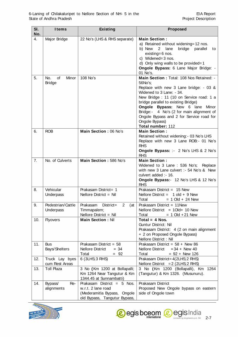
6-Laning of Chilakaluripet to Nellore Section of NH- 5 in the State of Andhra Pradesh
EIA ReportProject Description
2-7
Sl. No.
Items Existing Proposed
4. Major Bridge 22 No’s (LHS & RHS separate) Main Section : a) Retained without widening=12 nos. b) New 2 lane bridge parallel to
existing=6 nos. c) Widened=3 nos. d) Only wing walls to be provided=1 Ongole Bypass: 6 Lane Major Bridge: - 01 No’s.
5. No. of Minor Bridge
108 No’s Main Section : Total: 108 Nos Retained: - 56No’s; Replace with new 3 Lane bridge: - 03 & Widened to 3 Lane: - 34. New Bridge : 11 (10 on Service road: 1 a bridge parallel to existing Bridge) Ongole Bypass: New 6 lane Minor Bridge:- 4 No’s (2 for main alignment of Ongole Bypass and 2 for Service road for Ongole Bypass) Total number: 112
6. ROB Main Section : 06 No’s Main Section : Retained without widening:- 03 No’s LHS Replace with new 3 Lane ROB:- 01 No’s RHS Ongole Bypass: :- 2 No’s LHS & 2 No’s RHS
7. No. of Culverts Main Section : 586 No’s Main Section : Widened to 3 Lane : 536 No’s; Replace with new 3 Lane culvert :- 54 No’s & New culvert added :- 16. Ongole Bypass:- 12 No’s LHS & 12 No’s RHS
8. Vehicular Underpass
Prakasam District= 1 Nellore District = Nil
Prakasam District = 15 New Nellore District = 1 old + 9 New Total = 1 Old + 24 New
9. Pedestrian/Cattle Underpass
Prakasam District= 2 (at Timmapalem; Nellore District = Nil
Prakasam District = 11New Nellore District = 1Old+ 10 New Total = 1 Old +21 New
10. Flyovers Main Section : Nil Total = 4 Nos. Guntur District: Nil Prakasam District: 4 (2 on main alignment + 2 on Proposed Ongole Bypass) Nellore District : Nil
11. Bus Bays/Shelters
Prakasam District = 58 Nellore District = 34 Total = 92
Prakasam District = 58 + New 86 Nellore District =34 + New 40 Total = 92 + New 126
12. Truck Lay byes cum Rest Areas
6 (3LHS;3 RHS)
Prakasam District=4(2LHS;2 RHS) Nellore District =2 (2LHS;2 RHS)
13. Toll Plaza 3 No (Km 1200 at Bollapalli; Km 1264 Near Tangutur & Km 1344.45 at Sunnambatti)
3 No (Km 1200 (Bollapalli), Km 1264 (Tangutur) & Km 1326. (Musunuru).
14. Bypass/ Re-alignments
Prakasam District = 5 Nos. w.r.t. 2 lane road (Mederamitla Bypass, Ongole old Bypass, Tangutur Bypass,
Prakasam District Proposed New Ongole bypass on eastern side of Ongole town

6-Laning of Chilakaluripet to Nellore Section of NH- 5 in the State of Andhra Pradesh
EIA ReportProject Description
2-8
Sl. No.
Items Existing Proposed
Singaryakonda Bypass, Ulvapalem Bypass) Nellore District = 2 Nos. w.r.t. 2 lane road (Kavali Bypass, Rajupalem Bypass)
15. Street Light -Nil Prakasam District= 25 locations (22.470 Km) Nellore District = 10 locations (8.240Km) Total = 35 locations Total 31.610 Km
16. High Mast Light Nil Prakasam District: 6 (4 on main alignment, 2 locations on Ongole Byepass) At Bollapalli Toll plaza, Medarametla / Addanki Jn. Chirala Jn., Start and End of Ongole Bypass and Tangaturu Toll Plaza
Nellore District: at 1 Location at Masunuru Toll Plaza
17. Service Road Guntur District: Nil Prakasam District: 10 locations Covering 13.260 Km Nellore District: Nil
Additional Service Road at 115 Locations Guntur District = Nil Prakasam District=74(27.446 Km) Nellore District= 41 (14.884Km) Total = 84.66 Km on either side
18. Wayside Amenity Centres
1 No’s Guntur District = Nil Prakasam District= 4 locations Nellore District = 2 locations
19. Crash Barrier - Total at 86 Locations Prakasam District= 53 locations Nellore District = 33 locations
20 Construction Cost of the Project
Rs. 1,002.24 Crores for Main Section 231.08 Ongole Bypass Total = 1,233.32 crores
14. Bypass/ Re-alignments
Prakasam District = 5 Nos. w.r.t. 2 lane road (Mederamitla Bypass, Ongole old Bypass, Tangutur Bypass, Singaryakonda Bypass, Ulvapalem Bypass) Nellore District = 2 Nos. w.r.t. 2 lane road (Kavali Bypass, Rajupalem Bypass)
Prakasam District Proposed New Ongole bypass on eastern side of Ongole town
15. Street Light -Nil Prakasam District= 25 locations (22.470 Km) Nellore District = 10 locations (8.240Km) Total = 35 locations Total 31.610 Km
16. High Mast Light Nil Prakasam District: 6 (4 on main alignment, 2 locations on Ongole Byepass) At Bollapalli Toll plaza, Medarametla / Addanki Jn. Chirala Jn., Start and End of Ongole Bypass and Tangaturu Toll Plaza
Nellore District: at 1 Location at Masunuru

6-Laning of Chilakaluripet to Nellore Section of NH- 5 in the State of Andhra Pradesh
EIA ReportProject Description
2-9
Sl. No.
Items Existing Proposed
Toll Plaza
17. Service Road Guntur District: Nil Prakasam District: 10 locations Covering 13.260 Km Nellore District: Nil
Additional Service Road at 115 Locations Guntur District = Nil Prakasam District=74(27.446 Km) Nellore District= 41 (14.884Km) Total = 84.66 Km on either side
18. Wayside Amenity Centres
1 No’s Guntur District = Nil Prakasam District= 4 locations Nellore District = 2 locations
19. Crash Barrier - Total at 86 Locations Prakasam District= 53 locations Nellore District = 33 locations
20 Construction Cost of the Project
Rs. 1,002.24 Crores for Main Section 231.08 Ongole Bypass Total = 1,233.32 crores
2.7 Existing Scenario & proposed Plan for Project
2.7.1 Chilkaluripet to Nellore NH-5 Section
The NH-5 follows different chainage systems from Chennai to Kolkota i.e. starting point at
Chennai, Vjayawada etc. The NHAI has issued a circular stating that new chainage for NH-5 will
start from the Baharagora (near Kolkata) to Chennai under Golden Quadrilateral project. There
was some chainage equations developed at the time of 4 lane construction due to construction
of the bypasses along the project highway. For easy reference the chainage equations along the
project highway is given in Table 2.2.
Table 2.2: Chainage Details Package Section Chainage Length
(km) Type From To AP-11 Nellore -
Kavali
As Built Chainage 178+200 222+000 43.8
New Chainage 1366+547.143 1322+750.143
AP-12 Kavali -
Ongole
As Built Chainage 222+000 291+000 72.0
New Chainage 1322+750.143 1250+691.149
AP-13 Ongole -
Chilakaluripet
As Built Chainage 291+000 358+000 67.8
New Chainage 1250+691.149 1182+802.339
Total length (Km) 183.6
2.7.2 Proposed Ongole Bypass section
The widening of the existing old 4 lane Ongole bypass to six laning would involve significant land
acquisition and demolition of existing properties along the highway. Moreover, the presence of
about 540m elevated 4-lane viaduct adds to technical complexity in widening or proposing a new
elevated section. There were many representations in the past from local public to provide a

6-Laning of Chilakaluripet to Nellore Section of NH- 5 in the State of Andhra Pradesh
EIA ReportProject Description
2-10
bypass for Ongole. The Proposed Bypass is on the eastern side of existing NH-5 taking off at KM
1241+450, Crossing Railway line twice, passes through green fields and ends at Km 1251+700
of NH-5. The total length of bypass is 10.125 Km.
2.7.3 Right of Way (ROW)
The available Right of Way (RoW) for the existing 4 lane road is varying between 40m to 60m,
the minimum range is applicable through some sections where in the previous 4 laning contract
the land acquisition was done only up to limits. Hence, in places where the currently proposed
ROW is 66m in rural areas and 50m in urban areas, further acquisition is required for 6-laning
with service roads. In the case of proposed bypass at Ongole, it is proposed to have 80m RoW.
As per the preliminary design, the proposed Right of Way (RoW) for the new by-pass road is
varying between 80m to 84m. As the proposed by-pass is entirely new, the land acquisition is to
be done all along the project road. At chainage 9+915 the proposed RoW is 150m. In addition to
this there is one existing connectivity road (Gravel Road) at chainage 0+700 where the proposed
RoW is 30m. Hence, as the proposed by-pass is entirely new land acquisition is required all
along the project road.
2.7.4 Additional Land Requirement for Widening
A total area of 270.97 Ha of land will be required for acquisition to accommodate proposed
widening beyond existing ROW. The area includes 186.02 Ha for main alignment and 84.95 Ha
for proposed Ongole Bypass.
Out of the total land acquisition only marginal land area of 0.5619 Ha will be needed from
Guntur District, whereas from Prakasam District the total land requirement for acquisition is
197.15 ha (112.19 Ha for main alignment and 84.95 Ha for proposed Ongole Bypass) and the
same from Nellore District is 73.26 Ha. The village wise breakup of the land requirement is given
in Annexure-2.1.
2.7.5 Traffic Scenario
The traffic volume count data collected has been analysed to assess the traffic intensity in
various homogeneous sections of the corridor. The Average Daily Traffic (ADT) in base year 2007
minimum is 7077 vehicles (15285 PCU) in section Chilakaluripet – Medarametla and maximum is
11479 vehicles (23999 PCU) in Ongole-Kavali sections. The share of non motorised vehicles is
very less (maximum being 2.1%), whereas the share of tollable traffic is about 70% and in terms
of numbers, this vary between 5300 vehicles and 7970 vehicles The peak hour traffic as a
percentage of ADT vary between 5.5% to 7% indicating fairly uniform distribution of traffic over
the day. Table 2.3 presents the summary of Average Daily Traffic at all the four traffic
homogeneous sections. Following are the salient findings:

6-Laning of Chilakaluripet to Nellore Section of NH- 5 in the State of Andhra Pradesh
EIA ReportProject Description
2-11
Table 2.3: Average Daily Traffic at Traffic Homogeneous Sections
S. No. Traffic Count Station Location AADT Vehicles PCU’s
1 Chilakaluripet - Medarametla Bollapalli 7077 15285
2 Medarametla – Ongole Medarametla 10345 21790
3 Ongole – Kavali Tanguturu 11479 23999
4 Kavali - Nellore Musnuru 10602 22732
2.7.5.1 Travel Pattern
Little over 4000 vehicles (>11300PCU) pass through the entire corridor, which is 70% of the
total traffic in Chilakaluripet-Medarametla Section & 44-49% in other sections. Over 15200 PCU
(5400 vehicles) is the traffic that is through to Medarametla-Nellore Section of the corridor
(travelling 148km out of the total 182 Km) which is about 70% of the total corridor length.
Medarametla is the major diversion point on the project corridor with over 2000 freight vehicles
getting off at this location. The tollable traffic that would be using only one section or part
thereof is generally less than 5% except in Ongole-Kavali section where it is 11% (this however
does not include traffic diversion taking place at Medarametla. The estimated by passable traffic
to Ongole city is about 5900 vehicles (about 15900PCU) for recommended option of bypass
alignment.
2.7.5.2 Traffic Growth rates
The traffic growth rates adopted for the project highway are finalized based on the past trend
analysis and analysis of the economic indicators of the project influence area and presented in
Table 2.4.
Table 2.4: Proposed Traffic Growth Rate (%) for Different types of Vehicles
Vehicle Type < =
2010 2011-2015
2016-2020 > 2020
2 Wheelers 6.1 5.1 4.4 4.4
Car 6.6 5.6 4.9 4.4
Bus 5.5 4.6 3.9 3.5
LCV/ 2 Axle Truck 6.5 6.0 5.0 4.0
Multi Axle Truck 7.2 6.6 5.5 4.5
2.7.5.3 Traffic Projection
The total traffic on the project highway will be the sum of normal traffic, diverted traffic and
generated traffic. The total estimated traffic on the traffic homogeneous sections and proposed
Ongole bypass are projected with respect to adopted traffic growth rates and presented in Table 2.5.
Table 2.5: Projected Traffic at the Homogeneous Traffic Sections
Year Car/
Jeep/ Van
Mini Bus/ LCV
Bus/ Truck
3 Axle
TruckMAV
Total Vehicles (in Nos.) Total Vehicles (in PCUs) Tollable
Non-Tollable
Total Tollable
Non-Tollable
Total
Chilakaluripet-Medarametla Section 2010 1439 552 2051 2288 415 6745 2026 8771 17152 1979 19131
2015 1883 707 2611 3005 544 8750 2456 11206 22240 2300 24540
2020 2384 875 3216 3817 691 10983 2910 13893 27905 2634 30539
2025 2941 1040 3821 4644 841 13287 3467 16754 33681 3038 36719

6-Laning of Chilakaluripet to Nellore Section of NH- 5 in the State of Andhra Pradesh
EIA ReportProject Description
2-12
Year Car/
Jeep/ Van
Mini Bus/ LCV
Bus/ Truck
3 Axle
TruckMAV
Total Vehicles (in Nos.) Total Vehicles (in PCUs) Tollable
Non-Tollable
Total Tollable
Non-Tollable
Total
2030 3627 1235 4538 5650 1024 16074 4142 20216 40652 3508 44160
2035 4475 1467 5389 6874 1245 19450 4966 24416 49067 4070 53137
2040 5523 1742 6401 8364 1514 23544 5975 29519 59244 4744 63988
Medarametla-Ongole Section 2010 1777 608 2923 3416 567 9291 3499 12790 24258 3038 27296
2015 2325 779 3721 4486 745 12056 4280 16336 31467 3568 35035
2020 2944 966 4583 5698 946 15137 5114 20251 39493 4126 43619
2025 3627 1147 5443 6932 1151 18300 6132 24432 47652 4791 52443
2030 4472 1363 6464 8434 1401 22134 7375 29509 57515 5583 63098
2035 5515 1619 7677 10261 1704 26776 8899 35675 69426 6534 75960
2040 6802 1922 9118 12485 2073 32400 10769 43169 83823 7686 91509
Ongole-Kavali Section 2010 1880 757 3213 3615 684 10149 4067 14216 26578 3517 30095
2015 2463 969 4088 4748 899 13167 5031 18198 34470 4163 38633
2020 3122 1202 5031 6031 1142 16528 6073 22601 43250 4858 48108
2025 3856 1427 5975 7337 1389 19984 7345 27329 52183 5682 57865
2030 4763 1695 7097 8927 1690 24172 8913 33085 62983 6687 69670
2035 5886 2013 8430 10861 2056 29246 10831 40077 76031 7877 83908
2040 7273 2390 10012 13214 2502 35391 13195 48586 91795 9331 101126
Proposed Ongole Bypass 2010 791 589 1818 3289 666 7153 181 7334 19992 352 20344
2015 1039 788 2433 4527 916 9704 200 9903 27225 389 27614
2020 1320 1005 3106 5917 1197 12545 215 12759 35283 403 35687
2025 1637 1222 3778 7374 1492 15504 231 15735 43642 419 44061
2030 2030 1486 4597 9189 1859 19163 250 19412 53986 437 54424
2035 2518 1808 5593 11451 2317 23688 270 23958 66791 457 67248
2040 3123 2199 6805 14271 2888 29285 292 29578 82643 479 83121
Kavali-Nellore Section 2010 2031 800 3190 3368 722 10111 3019 13130 26154 2437 28591
2015 2658 1025 4064 4423 949 13119 3649 16768 33927 2851 36778
2020 3366 1270 5010 5618 1205 16469 4332 20801 42578 3297 45875
2025 4151 1509 5949 6835 1466 19910 5164 25074 51364 3832 55196
2030 5120 1792 7066 8316 1784 24078 6173 30251 61982 4471 66453
2035 6316 2129 8392 10118 2171 29126 7402 36528 74809 5233 80042
2040 7794 2528 9966 12310 2641 35239 8897 44136 90299 6141 96440
2.7.6 Pedestrian Flow
There are quite a few major settlements along the project corridor where considerably high pedestrians
cross the highway. Pedestrian survey was conducted at major settlement area. The summary of
pedestrian flows at important locations is presented in Table 2.6 below.
Table 2.6: Pedestrian Flows across Highway
Location 12 Hour Flows Peak Hour Flows PV2 (1 X 10⁸)Muppavaram 1598 213 0.6
Gowravaram 5089 591 3.6
Konanki 2250 355 0.9

6-Laning of Chilakaluripet to Nellore Section of NH- 5 in the State of Andhra Pradesh
EIA ReportProject Description
2-13
Marturu 13408 1303 3.4
Valluramma Devasthanam 3687 470 3.3
Narnevaripalem 4233 467 1.6
2.7.7 Service Roads
The service roads exist at only few locations in the stretch extending in Prakasam district covering a total
length of 13.260 Km. In order to make the project road access control and ascertaining the safety of
local traffic and people additional servicer roads have been provided at 115 locations covering a total
length of 84.66 Km on either side. The lists of existing and proposed service roads are presented in
Annexure-2.2.
2.7.8 Vehicular/Pedestrian Underpasses
It is proposed to provide a total number of 23 new vehicular/ pedestrian underpasses and at different
locations wherever settlement areas are coming along the project corridor. 1 vehicular underpass has
been proposed at proposed Ongole bypass. 1 existing vehicular underpass located at Km 1320/3 and 1
Pedestrian/Cattle Underpasses will be retained. The newly proposed vehicular underpasses and
pedestrian/cattle underpasses are given in Table 2.7.
Table 2.7: Proposed Vehicular Underpasses and Pedestrian/Cattle Underpasses
S. No
Chainage km
Span arrangement
Minimum Vertical
Clearance (m)
Total width* (m)
Remark
1 1188.290 1x12m 5.0 2 x 13.50m Martur Town
2 1195.855 1x12m 5.0 2 x 13.50m Konanki
3 1202.040 1x12m 5.0 2 x 13.50m Narnivanipalem
4 1204.900 1x12m 5.0 2 x 13.50m Muppavaram
5 1209.620 1x12m 5.0 2 x 13.50m Renangivaram
6 1227.000 1x12m 5.0 2 x 13.50m Gullapalli
7 1231.503 1x12m 5.0 2 x 13.50m Maddipadu
8 1260.275 1x12m 5.0 2 x 13.50m Sorareddypalem Industrial
9 1264.648 1x12m 5.0 2 x 13.50m Tangaturu Bypass
10 1266.195 1x12m 5.0 2 x 13.50m Tangaturu Bypass
11 1267.400 1x12m 5.0 2 x 13.50m Tangaturu Bypass
12 1273.700 1x12m 5.0 2 x 13.50m Singarayakonda Bypass
13 1278.087 1x20m 5.0 2 x 13.50m Kandukuru road,
Singarayakonda Bypass
14 1280.185 1x12m 5.0 2 x 13.50m Singarayakonda Bypass
15 1309.950 1x12m 5.0 2 x 13.50m Rudrakota
16 1313.811 1x12m 5.0 2 x 13.50m Kavalai bypass
17 1323.950 1x12m 5.0 2 x 13.50m Kavalai bypass
18 1336.620 1x12m 5.0 2 x 13.50m Bogollu
19 1345.980 1x12m 5.0 2 x 13.50m Sunambhatti
20 1356.825 1x12m 5.0 2 x 13.50m Naidupalem
21 1358.950 1x12m 5.0 2 x 13.50m Rajupalem Byapss
22 1360.460 1x12m 5.0 2 x 13.50m Rajupalem Byapss
23 1366.200 1x20m 5.0 2 x 13.50m Nellore Bypass
New Vehicular Underpass for Ongole Bypass

6-Laning of Chilakaluripet to Nellore Section of NH- 5 in the State of Andhra Pradesh
EIA ReportProject Description
2-14
24 5.760 1x12m 5.0 2 x 13.50m Ongole Bypass
Vehicular Underpass to be retained
S. No
Structure No. /
Chainage Location Repair and Rehabilitation Measures
1 1320/3 LHS & RHS Repair damaged wearing coat, drainage spout gratings missing, repair approach slab settlement
New Pedestrian/Cattle Underpasses
S. No
Chainage km
Span arrangement
Minimum Vertical
Clearance (m)
Total width* (m) Remark
1 1193.680 1x7.5m 3.5 2 x 13.50m Darshiagraharam
2 1207.380 1x7.5m 3.5 2 x 13.50m Jagarla Muduvaripalem
3 1215.020 1x7.5m 3.5 2 x 13.50m Korisepadu
4 1238.650 1x7.5m 3.5 2 x 13.50m Yendukondlapadu
5 1252.664 1x7.5m 3.5 2 x 13.50m Pelluru
6 1256.200 1x7.5m 3.5 2 x 13.50m Valluramma
7 1270.900 1x7.5m 3.5 2 x 13.50m Bitragunta
8 1288.120 1x7.5m 3.5 2 x 13.50m Kollurupadu
9 1297.492 1x7.5m 3.5 2 x 13.50m Veerapalli
10 1301.522 1x7.5m 3.5 2 x 13.50m Tettu (Ramayapatnam)
11 1305.817 1x7.5m 3.5 2 x 13.50m Ravuru
12 1311.900 1x7.5m 3.5 2 x 13.50m Maddurupadu
13 1322.000 1x7.5m 3.5 2 x 13.50m Musnur
14 1328.890 1x12m 3.5 2 x 13.50m Gauravaram
15 1333.265 1x12m 3.5 2 x 13.50m Kadanutala
16 1334.750 1x12m 3.5 2 x 13.50m Kadanutala
17 1340.650 1x7.5m 3.5 2 x 13.50m Ulavapadu
18 1350.315 1x7.5m 3.5 2 x 13.50m Racharlapadu
19 1353.500 1x12m 3.5 2 x 13.50m Regadichilaka
20 1355.713 1x7.5m 3.5 2 x 13.50m Buddavaripalem
21 1365.300 1x7.5m 3.5 2 x 13.50m Kovuru Bus Stand
Pedestrian/Cattle Underpasses to be retained S. No
Structure No. / Chainage
Location Repair and Rehabilitation Measures
1 1224/1
1223+121
LHS &
RHS Provide boulder pitching on earth fill around abutments
2.7.9 Cart Tracks
Apart from vehicular underpasses and pedestrian underpasses, 3 m wide cart tracks have been
proposed for Ongole Bypass in order to facilitate the movement of cart across the highway
section. The location of cart tracks for Ongole Bypass has been listed in Table 2.8.
Table 2.8: Cart Tracks for Ongole Bypass
Chainage(km) Width (m) Length (km)
1.020 2.960 3 1.940
2.960 3.200 3 0.240

6-Laning of Chilakaluripet to Nellore Section of NH- 5 in the State of Andhra Pradesh
EIA ReportProject Description
2-15
3.740 4.020 3 0.280
4.020 4.790 3 0.770
4.910 5.460 3 0.550
6.020 7.605 3 1.585
7.625 8.260 3 0.635
8.260 8.660 3 0.400
9.240 9.600 3 0.360
One side length of Cart Track 6.76 Both side length of Cart Track 13.52
2.7.10 Bridges
There are of 22 Major Bridges (Total length > 60.0 m), 108 Minor Bridges (6.0 m < Total Length
<60.0m), 6 ROBs, 4 underpasses/ cattle crossings and 586 culverts on the project road. At few
locations culverts have been provided for service roads. All the numbers of structures mentioned
above are for individual 2/3–lane carriageways. Palleru Bridge is the longest bridge on the
project road. 12 Number of bridges will be retained without widening, whereas 3 bridges will be
widened to 3-lane whereas for remaining 6 bridge locations additional 2-lane bridges are
proposed in the project. Apart from these one new 6-lane Major Bridge has been proposed on
new Ongole bypass.
There are 108 numbers of existing minor bridges in the project. Out of 108, 56 minor bridges will
be retained, 3 will be replaced with new 3 Lane bridge and 34 minor bridges will be widened to 3
lane. It has been proposed to construct 11 new bridges (10 on Service road and 1 a bridge
parallel to existing Bridge).On proposed Ongole bypass construction of 4 new minor bridges have
been proposed 2 on main alignment and 2 on service roads.
2.7.11 Rail Over Bridge (ROB)
There are 4 Rail over Bridge exist in the project stretch. Out of these 3 will be retained with
repairs whereas one ROB will be replaced. 2 new ROBs have been proposed on new Ongole
bypass. The details of ROB are given in Annexure-2.3.
2.7.12 Culverts
There are 586 culverts along the entire project road out of which 54 numbers of culverts will be
replaced with new 3-lane culverts, 536 culverts will be widened to 3-lane and a total number of
16 additional culverts will be provided in the main section. 2 new culverts have been proposed
for new Ongole bypass.
2.7.13 Toll Plazas
Existing Toll plazas
There are three toll plazas along the project corridor. The details of the existing toll plazas are
given in Table 2.9.
Table 2.9: Existing Toll Plazas
S. No. Chainage Toll Section Remarks
1 Km 1200 Bollapalli Km 1182.802 to Km 1253.75 (70.948km)
Chilakaluripet – Ongole
2 Km 1264 Km 1253.75 to Km 1322.750 (69km) Ongole – Kavali

6-Laning of Chilakaluripet to Nellore Section of NH- 5 in the State of Andhra Pradesh
EIA ReportProject Description
2-16
S. No. Chainage Toll Section Remarks
Near Tangutur
3 Km 1344.45 Sunnambatti**
Km 1322.750 to Km 1383.713 (61km*) Kavali - Nellore
Proposed Toll Plaza Locations
The current project length is about 183.7km and going by the norm of one toll plaza in every 60-
80km the appropriate number of toll plazas works out to 2-3. However, considering the location
of major towns and travel pattern along the corridor 4 toll plazas would be required. If 4 toll
plazas are planned, the spacing of toll plazas will be reduced as two toll plazas are required to be
placed in Chilakaluripet-Ongole section (70km) itself (considering the travel pattern). Thus the
number toll plazas cannot be more than 3. This leaves with the option of placing one toll plaza
each in the following sections:
Chilakaluripet – Ongole (includes the Ongole Bypass section)
Ongole – Kavali
Kavali - Nellore
The recommended locations for toll plaza and tolling sections are presented in Table 2.10.
Table 2.10: Proposed Toll Plaza Locations
S. No.
Tolling Section
Tolling Section Length, km
Location Inter-Toll Plaza Distance, Km
Toll Lanes Remarks
1 Chilakaluripet – Ongole
60.695 and Ongole bypass of length 10.125 Km
Km 1200 (Bollapalli)
80.4 6+6 Lanes Existing Location
2 Ongole – Kavali
69.0 Km 1264, Tangutur
64 6+6 Lanes Existing Location
3 Kavali – Nellore
43.8 Km 1326 (Masnuru)
62 6+6 Lanes New Location
2.7.14 Facilities and Services to the Users Bus Bays
There are as many as 92 bus bay and bus bays with shelters exist along the project highway for
the safety of Pedestrian movement. It is also felt that a few more bus bays with shelters are
required at some places. All these bus bays will be utilized for widening into 6-lane and new bus
bays will be constructed on the outer side of the proposed service lane near the existing
locations. A total number of 126 new Bus Bays with Shelters have been proposed at different
locations. The list of those proposed bus bays with shelters is presented in Annexure 2.4.
Truck Lay byes cum Rest Areas
At present no truck laybyes is provided in the project stretch. New Truck laybyes cum rest areas
has been proposed at the 3 locations, the details of which are given in Table 2.11 along the
project corridor.

6-Laning of Chilakaluripet to Nellore Section of NH- 5 in the State of Andhra Pradesh
EIA ReportProject Description
2-17
Table 2.11: Truck Lay-Bys cum Rest Area
S. No. Chainage (Km) LHS Chainage (Km) RHS
Prakasam District
1 1185.430 1185.050
2 1256.170 1264.560
Nellore District
3 1329.510 1331.170
Wayside Amenities
For the road user, wayside amenities such as drinking water, telephone booths, bus shelters and
road side rest areas are of value. The industrialisation and socio-economic development has
increased the use of telephones. Telephone booths are often available in urban areas but their
provision along highway would also be beneficial. Road side rest areas are essential for long
distance road travellers of main highway. Long distance journey’s cause driver fatigue resulting
in poor driving and increase in driver reaction time. In India such services are starting to be
provided but more are needed. To promote safer driving, drivers should be encouraged to have
adequate rest when they feel tired. The existing wayside amenity centres and proposed new
wayside amenities location are given below (Table 2.12).
Table 2.12: Proposed Wayside Amenity locations S. No. LHS RHS
Prakasam District 1 1185430 1185050
2 1256170 1264560
Nellore District 3 1329510 1331170
Street Lighting
The number of urban and habituated area is along the project highway. At present no street
lights have been provided on the highways section in this stretch. The street light has been
proposed along the town/ villages for safe movement of traffic on the service road. The proper
lighting has been proposed at all Pedestrian Subway & Underpass, Vehicular Underpasses.
The all entry exit ramps along the project highway should be properly lighted. The lighting
system has been proposed at all the bus shelters and the rest area. Table 2.13 depicts the
proposed location of street lighting provision in the project stretch.
Table 2.13: Proposed Locations of Street lighting
Locations of Street lighting S.
No. Village/town Name Chainage
Length (m) From To
1 Marturu 1185.8 1192 6200
2 Konanki 1195.4 1196.6 1200
3 Muppavaram 1204.2 1205.6 1400
4 Jagarlamudivaripalem 1207.38 1207.7 320
5 Redangivaram 1208.6 1209.7 1100
6 Korispadu 1214.3 1214.7 400
7 Thimmanapalem 1223 1224 1000
8 Gullapalli 1226.5 1227.8 1300

6-Laning of Chilakaluripet to Nellore Section of NH- 5 in the State of Andhra Pradesh
EIA ReportProject Description
2-18
9 Maddipadu 1230.4 1232.7 2300
10 Kostalu 1233.4 1234.2 800
11 Yedugutlapadu 1240.5 1241.45 950
Start of Ongole Bypass 12 Flyover/VUP 0.68 0.78 100
13 PUP 2.96 3.06 100
14 VUP 5.71 5.81 100
15 PUP 8.16 8.26 100
16 Flyover 9.71 9.81 100
End of Proposed Bypass 17 Pelluru 1252.2 1253.1 900
18 Valluru 1256.4 1256.7 300
19 Sorareddypalem 1257.5 1257.8 300
20 Kalika Bitragunta 1270.3 1271 700
21 Karadu 1283.7 1284.1 400
22 Chagallu 1294.6 1294.9 300
23 Mocharla 1300.2 1300.8 600
24 Tettu 1301.4 1302.4 1000
25 Ravuru 1304.2 1304.7 500
26 Maddurupadu 1311.8 1313.5 1700
27 Gauravaram 1328.5 1329.3 800
28 Kadumetla 1332.9 1333.7 800
29 Bogollu 1336.3 1337.1 800
30 Ullavapadu 1340 1340.6 600
31 Sunnabhatti 1345.8 1346.6 800
32 Racharlapadu 1350.1 1350.5 400
33 Regadachilaka 1353 1354.3 1300
34 Boddavaripalem 1355.08 1355.42 340
35 Naidupalem 1356.8 1357.5 700
Total Length (m) 31610
Highway Lighting
The High mast lighting has been proposed at the following location along the project highway:
Table 2.14: Proposed Locations of Highway Lighting
\
S. No. Chainage Location 1 1200.000 Bollapalli Toll plaza
2 1218.100 Medarametla / Addanki Jn.
3 1240.000 Chirala Jn.
Start of Proposed Ongole Bypass 4 0150.000 Ongole City outskirts(Bypass start)
5 0975.000 Ongole City outskirts(Bypass End)
End of Proposed Ongole Bypass 6 1264.000 Tangaturu Toll Plaza
7 1326.000 Masunuru Toll Plaza

6-Laning of Chilakaluripet to Nellore Section of NH- 5 in the State of Andhra Pradesh
EIA ReportProject Description
2-19
Pedestrian Guard Railing
The pedestrian guard railing between the service road and the main carriageway has been
proposed along the urban sections and the villages/towns area along the project highway for the
safe movement of the pedestrian traffic. The railing is not required along the length of villages
where the underpasses have been proposed.
The pedestrian guard rails has been proposed between the nearest at grade junction and the bus
stop for the safe movement of the pedestrian traffic. Table 2.15 presents the locations of
proposed guard railing in the project stretch.
Table 2.15: Proposed Locations of Pedestrian Guard Railing
S. No. Chainage (km)
Length (m) From To
Prakasam District 1 1185.800 1187.860 2060
2 1188.720 1193.000 4280
3 1195.450 1195.618 168
4 1196.093 1196.250 157
5 1204.000 1204.651 651
6 1230.750 1231.254 504
7 1231.752 1232.260 508
8 1239.500 1239.763 263
9 1252.300 1252.458 158
10 1252.870 1253.000 130
11 1256.406 1257.000 594
Nellore District 12 1312.106 1313.574 1468
13 1328.400 1328.653 253
14 1329.128 1329.400 272
One side length 11466 Both side length 22932
Crash Barrier
About 21km of concrete crash barrier exists as Service Road and main carriageway separator or
at bridge approaches. The metal beam crash barrier exists at high embankment and bridge
locations for a length of 19km.
The W beam/ concrete safety barrier has been proposed along the project highway at following
locations:
Where the embankment height is 3m or more
Where the embankment is retained by retaining structure
Where the median is less than 4.5m
Both side approach for the Minor & Major Bridges
At sharp horizontal curves locations
6-Laning of Chilakaluripet to Nellore Section of NH- 5 in the State of Andhra Pradesh
EIA ReportProject Description
2-20
2.7.15 Traffic Sign and Pavement Marking
The gantry sign mounted on post indicating the village name and the important road it would lead
to at all exit locations. The position of these signs should meet the requirement of the IRC 67 and
Manual for six laning. The pavement marking along the project highway should meet the
requirement of the IRC 35 and Manual for six laning. The proper zebra marking has been proposed
at the Underpass locations for safe crossing of the pedestrian traffic. The safety features such as
delineators, cat’s eyes, hazard markers and safety barrier at hazardous locations has been proposed
on the project highway.
2.8 Typical Cross Section:
The proposed ROW is 66m in rural section where as 45 m in urban builtup areas. At number of
places service lanes, crass barriers have been provided. Based on widening proposal and facilities
typical cross sections have been developed to depict the proposed widening at different locations.
In all the 6 Reserved forest pockets which are located adjacent to the existing ROW, it has been
proposed to widened the highway section within available ROW by providing retaining wall/
toewalls. Typical cross sections have been given below as Figure 2.4a, 2.4b, 2.4c, 2.4d, 2.4e.

6-Laning of Chilakaluripet to Nellore Section of NH- 5 in the State of Andhra Pradesh
EIA ReportProject Description
2-21
Figure 2.4 a: Typical Cross Section

6-Laning of Chilakaluripet to Nellore Section of NH- 5 in the State of Andhra Pradesh
EIA ReportProject Description
2-22
Figure 2.4 b: Typical Cross Section

6-Laning of Chilakaluripet to Nellore Section of NH- 5 in the State of Andhra Pradesh
EIA ReportProject Description
2-23
Figure 2.4 c: Typical Cross Section

6-Laning of Chilakaluripet to Nellore Section of NH- 5 in the State of Andhra Pradesh
EIA ReportProject Description
2-24
Figure 2.4d: Typical Cross Section in Reserved Forest Section
Proposed Cross Section of 6-Lane Carriageway Type-1 with toe wall in Forest Section where sufficient ROW is not available

6-Laning of Chilakaluripet to Nellore Section of NH- 5 in the State of Andhra Pradesh
EIA ReportProject Description
2-25
Figure 2.4e: Typical Cross Section in Reserved Forest Section
Proposed Cross Section of 6-Lane Carriageway Type-1 with 2.4m high fencing and RCC retaining wall in Forest Section where sufficient ROW is not available
6-Laning of Chilakaluripet to Nellore Section of NH- 5 in the
State of Andhra Pradesh
EIA Report
Project Description (Annexure 2.1)
ANNEXURE-2.1
VILLAGEWISE AND DISTRICTWISE LAND AREA TO BE ACQUIRED WITHIN PROPOSED ROW THE PROJECT
A. Main Alignment
S.NO NAME OF VILLAGE NAME OF TALUK
AREA REQUIRED (in Sqmts)
OWNERSHIP (in Sqmts)
PRIVATE GOVERNMENT
DISTRICT - GUNTUR 1 Tatipudi Chilakaluripet 4612 3155 1457
2 Murikipudi 1007 567 440
TOTAL LAND IN SQ. MTS 5619 3722 1897 TOTAL LAND IN Ha 0.5619 0.3722 0.1897
DISTRICT - PRAKASAM 1 Rajupalem Marturu 11516.56 10969.60 546.96
2 Marturu 17554.44 16125.36 1429.08
3 Zonnatali 2752.64 2752.64 0
4 Isuka Darsi 20236.40 16370.32 3866.08
5 Konanki 23336.72 20928.16 2408.56
6 Lakkavaram 3157.44 3157.44 0
7 Bollapalli 14066.80 9877.12 4189.68
8 Kondamanjuluru J. Pangulur 29734.44 25767.40 3967.04
9 Baitamanjuluru 15382.40 12611.56 2770.84
10 Muppavaram 22710.72 15236.32 7474.4
11 Renangivaram 30086.76 25816.12 4270.64
12 Alavalapadu 11071.28 10241.44 829.84
13 Pichikulagudipadu 33344.23 24560.07 8784.16
14 Kondamur 19470.88 8228.32 11242.56
15 Addanki Korisapadu 2712.16 1862.08 850.08
16 Korisipadu Addanki 7956.92 7289.00 667.92
17 Bodduvaripalem Korisapadu 52330.52 38911.40 13419.12
18 Gundlapalli 66286.92 65174.92 1112
20 Maddipadu Maddipadu 29035.80 25273.36 3762.44
21 Seetharamapuram 22992.64 22709.28 283.36
22 Doddavarppadu 33203.72 30855.84 2347.88
23 Edugundlapadu 65467.96 61824.76 3643.2
24 Valluru Tangutur 42382.56 36189.12 6193.44
25 Thurpu Naidu palem 2995.52 2104.96 890.56
26 Valluru Kavali Manyam 3177.68 2894.32 283.36
27 Tanguturu 45904.68 35157.24 10747.44
28 Vaviletipadu Jarugumalli 7626.08 6371.20 1254.88
29 Bitragunta 41382.36 37298.60 4083.76
30 Kalikivaya Singarayakonda 6254.16 4371.84 1882.32
31 Mulaguntapadu 30862.64 23920.32 6942.32
32 Konumalla 15058.56 14086.04 972.52
33 Somarajupalli 3177.68 445.28 2732.4

6-Laning of Chilakaluripet to Nellore Section of NH- 5 in the
State of Andhra Pradesh
EIA Report
Project Description (Annexure 2.1)
S.NO NAME OF VILLAGE NAME OF TALUK
AREA REQUIRED (in Sqmts)
OWNERSHIP (in Sqmts)
PRIVATE GOVERNMENT
34 Singarayakonda Singarayakonda 37636.88 21853.08 15783.8
35 Karedu Ulavapadu 91120.48 89815.92 1304.56
36 Kollurupadurajupalem 82988.40 47689.82 35298.58
37 Chagollu 36023.20 29951.20 6072
38 Veerepalli 18944.64 14775.20 4169.44
39 Mocherla Gudlur 89624.60 35796.32 53828.28
40 Chevuru 32386.92 4621.40 27765.52
TOTAL LAND IN SQ. MTS 1121955.4 863884.4 258071.0
TOTAL LAND IN Ha 112.1955 86.3884 25.8071 DISTRICT - SPSR NELLORE
1 Rudrakota Kavali 42527 6814 35713
2 Musurnuru 36233 32073 4160
Kavali Bit-II 22687 11808 10879
3 Kavali Bit-I 26114 23649 2495
4 Maddurupadu 13736 6696 7040
5 Gowravaram 56082 35787 20295
6 Allimadugu Bogole 29652 18595 11057
7 Kovurupalli 33761 10200 23561
8 Bogole 21580 6612 14968
9 Ulavapalla Dagadarti 41524 11258 30266
10 Ananthavaram 30433 15777 14656
11 Kottapalli Kavuragunta 111491 51918 59573
12 Talamanchi Kodavalur 121008 85615 35393
13 Bodduvaripalem 64325 40305 24020
14 Gandavaram 26183 20939 5244
15 Rajupalem 9942 9451 491
16 Kovur Kovur 45367 45367 0
TOTAL LAND IN SQ. MTS 732645 432864 299811 TOTAL LAND IN Ha 73.2645 43.2864 29.9811
GRAND TOTAL IN SQ. MTS 1860219 1300470 559779 GRAND TOTAL IN Ha 186.0219 130.047 55.9779
B. Proposed New Ongole Bypass
S.NO NAME OF TALUK
NAME OF VILLAGE AREA REQUIRED (in Sqmts)
REMARKS
DISTRICT - PRAKSAM
1 Ongole Pelluru 219150.28 Area includes main
alignment and bypass
2 Annavarampadu 137751.87
3 Koppole 212154.93
4 Muktinuthalapadu 244309.03
5 Throvagunta 36208.05 Area includes main
alignment and bypass
TOTAL LAND IN SQ. MTS 849574.16
TOTAL LAND IN Ha 84.9574

6-Laning of Chilakaluripet to Nellore Section of NH- 5 in the
State of Andhra Pradesh
EIA Report
Project Description (Annexure 2.2)
ANNEXURE-2.2
A. EXISTING SERVICE ROADS ALONG PROJECT HIGHWAY SECTION S.No. Chainage (km) Length (m) Side Carriageway
Width(m) Place
From To PRAKASAM DISTRICT
1 1186.760 1189.100 2340 LHS 5.5 Marturu
2 1187.480 1189.100 1620 RHS 5.5 Marturu
3 1189.480 1191.780 2300 LHS 5.5 Marturu
4 1189.480 1189.680 200 RHS 5.5 Marturu
5 1195.580 1196.480 900 Both Side 5.5 Konanki
6 1201.480 1202.380 900 LHS 5.5 Kondamanjuluru
7 1203.790 1205.05 1260 LHS 5.5 Muppavaram
8 1230.700 1232.200 1500 RHS 5.5 Maddipadu
9 1240.700 1241.250 550 LHS 5.5 Yedugutlapadu
10 1240.700 1241.490 790 RHS 5.5 Yedugutlapadu
Total aggregate length 13.260 km
B. PROPOSED SERVICE/SLIP ROADS DETAILS Chainage(km)
Place Carriageway Width including signage (m)
Length (km) From To
A. GUNTUR DISRICT NIL NIL
B. PRAKASAM DISTRICT
1185.800 1187.860 RAJUPALEM/MARTURU 7.5 2.06
1187.860 1188.043 MARTURU 7.5 0.183
1188.043 1188.537 MARTURU 7.5 0.494
1188.537 1188.720 MARTURU 7.5 0.183
1188.720 1193.000 MARTHUR ZONNATALI ISUKA
DARSI 7.5 4.28
1193.000 1193.461 ISUKA DARSI 7 0.461
1193.461 1193.900 ISUKA DARSI 7.5 0.439
1195.450 1195.618 KONANKI 7.5 0.168
1195.618 1196.093 KONANKI 7.5 0.475
1196.093 1196.250 KONANKI 7.5 0.157
1201.790 1201.803 KONDAMANJULURU 7 0.013
1201.803 1202.278 KONDAMANJULURU 7.5 0.475
1202.278 1202.290 KONDAMANJULURU 7 0.012
1204.000 1204.651 MUPPAVARAM 7.5 0.651
1204.651 1205.149 MUPPAVARAM 7.5 0.498
1207.148 1207.613 MUPPAVARAM 6 0.465
1209.370 1209.371 RENANGIVARAM 7 0.001
1209.371 1209.869 RENANGIVARAM 7.5 0.498
1209.869 1209.870 RENANGIVARAM 7 0.001
1214.814 1215.226 ADDANKI 6 0.412
1217.800 1218.249 KORISAPADU 7.5 0.449
1218.249 1218.300 KORISAPADU 7 0.051
1226.740 1227.261 GUNDALAPALLI 6 0.521
1230.750 1231.254 MADDIPADU 7.5 0.504
1231.254 1231.752 MADDIPADU 7.5 0.498

6-Laning of Chilakaluripet to Nellore Section of NH- 5 in the
State of Andhra Pradesh
EIA Report
Project Description (Annexure 2.2)
Chainage(km) Place Carriageway Width
including signage (m) Length (km) From To
1231.752 1232.260 MADDIPADU 7.5 0.508
1238.450 1238.474 EDUGUNDLAPADU 7 0.024
1238.474 1238.826 EDUGUNDLAPADU 7.5 0.352
1238.826 1239.500 EDUGUNDLAPADU 7 0.674
1239.500 1239.763 EDUGUNDLAPADU/THAROVAGUNTA
7.5 0.263
1239.763 1240.327 THAROVAGUNTA 7.5 0.564
1240.500 1241.450 THAROVAGUNTA 7 0.950
START OF PROPOSED ONGOLE BYEPASS 0.000 0.400 THAROVAGUNTMAMIDIPALEM 7 0.400
0.400 1.020 PELLURU 7.5 0.620
5.460 6.020 PELLURU 7.5 0.560
9.600 10.125 PELLURU 7.5 0.525
END OF PROPOSED ONGOLE BYEPASS 1252.300 1252.458 PELLURU 7.5 0.158
1252.458 1252.870 PELLURU 7.5 0.412
1252.870 1253.000 PELLURU 7.5 0.130
1255.950 1255.994 VALLURU 5.5 0.044
1255.994 1256.406 VALLURU 6 0.412
1256.406 1257.000 VALLURU 7.5 0.594
1257.475 1257.975 VALLURU 7 0.500
1260.025 1260.026 THURPUNAIDUPALEM 7 0.001
1260.026 1260.524 THURPUNAIDUPALEM 7.5 0.498
1260.524 1260.525 THURPUNAIDUPALEM 7 0.001
1264.398 1264.423 TANGUTURU 7 0.025
1264.423 1264.873 TANGUTURU 7.5 0.450
1264.873 1264.898 TANGUTURU 7 0.025
1265.945 1265.946 TANGUTURU 7 0.001
1265.946 1266.444 TANGUTURU 7.5 0.498
1266.444 1266.445 TANGUTURU 7 0.001
1267.150 1267.151 TANGUTURU 7 0.001
1267.151 1267.649 TANGUTURU 7.5 0.498
1267.649 1267.650 TANGUTURU 7 0.001
1270.681 1271.120 BITRAGUNTA 6 0.439
1273.450 1273.489 MULASANTAPADU 7 0.039
1273.489 1273.912 MULASANTAPADU 7.5 0.423
1273.912 1273.950 MULASANTAPADU 7 0.038
1277.837 1277.852 KANUMALLA 7 0.015
1277.852 1278.322 KANUMALLA 7.5 0.470
1278.322 1278.337 KANUMALLA 7 0.015
1279.935 1279.936 SOMARAJUPALLE 7 0.001
1279.936 1280.434 SOMARAJUPALLE 7.5 0.498
1280.434 1280.435 SOMARAJUPALLE 7 0.001
1287.770 1287.914 KOLLURUPADU RAJUPALEM 5.5 0.144
1287.914 1288.326 KOLLURUPADU RAJUPALEM 6 0.412
1297.286 1297.698 VEERAPALLI/ MOCHERLA 6 0.412
1301.272 1301.316 MOCHERLA 5.5 0.044
1301.316 1301.728 MOCHERLA 6 0.412
1301.728 1301.772 MOCHERLA 5.5 0.044
6-Laning of Chilakaluripet to Nellore Section of NH- 5 in the
State of Andhra Pradesh
EIA Report
Project Description (Annexure 2.2)
Chainage(km) Place Carriageway Width
including signage (m) Length (km) From To
1305.600 1305.659 CHEVURU 5.5 0.059
1305.659 1305.976 CHEVURU 6 0.317
1305.976 1306.000 CHEVURU 5.5 0.024
C. NELLORE DISTRICT 1309.690 1310.211 RUDRAKOTA 6 0.521
1311.694 1312.106 MADDARUPADU 7.5 0.412
1312.106 1313.574 MADDARUPADU 7.5 1.468
1313.574 1314.049 KAVALI 7.5 0.475
1314.049 1314.311 KAVALI 7 0.262
1318.900 1319.350 KAVALI 7 0.450
1321.800 1321.808 MUSUNURU 5.5 0.008
1321.808 1322.192 MUSUNURU 6 0.384
1322.192 1322.200 MUSUNURU 5.5 0.008
1323.690 1324.211 MUSUNURU 7.5 0.521
1328.400 1328.653 GAURAVARAM 7.5 0.253
1328.653 1329.128 GAURAVARAM 7.5 0.475
1329.128 1329.400 GAURAVARAM 7.5 0.272
1333.015 1333.040 ALLIMADUGU 5.5 0.025
1333.040 1333.490 ALLIMADUGU 6 0.450
1333.490 1333.515 ALLIMADUGU 5.5 0.025
1334.500 1334.513 KOVVURUPALLI 5.5 0.013
1334.513 1334.988 KOVVURUPALLI 6 0.475
1334.988 1335.000 KOVVURUPALLI 5.5 0.012
1336.250 1336.349 ALLIMADUGU 7 0.099
1336.349 1336.892 ALLIMADUGU/ BHOGAVOLU 7.5 0.543
1336.892 1337.250 BHOGAVOLU 7 0.358
1339.900 1340.431 ULAVAPALLE 5.5 0.531
1340.431 1340.870 ULAVAPALLE 6 0.439
1345.720 1346.241 KAVULAGUTTA 6 0.521
1350.065 1350.109 TALAMANCHI 5.5 0.044
1350.109 1350.521 TALAMANCHI 6 0.412
1350.521 1350.565 TALAMANCHI 5.5 0.044
1352.900 1353.275 TALAMANCHI 7 0.375
1353.275 1353.725 TALAMANCHI/ BUDDUVARIPALEM
7.5 0.450
1353.725 1355.100 BUDDUVARIPALEM 7 1.375
1355.507 1355.919 BUDDUVARIPALEM 6 0.412
1355.919 1356.013 BUDDUVARIPALEM 5.5 0.094
1356.575 1356.576 BUDDUVARIPALEM 7 0.001
1356.576 1357.074 BUDDUVARIPALEM 7.5 0.498
1357.074 1357.075 BUDDUVARIPALEM 7 0.001
1358.679 1359.222 BUDDUVARIPALEM/ GANDAVARAM
7.5 0.543
1360.189 1360.732 GANDAVARAM/ RAJUPALEM 7.5 0.543
1365.068 1365.533 KOVUR 6 0.465
1365.533 1365.600 KOVUR 5.5 0.067
1365.920 1366.480 KOVUR 7.5 0.560
One side length of Service/Slip Road 42.330
Both side length of Service/Slip Road 84.660

6-Laning of Chilakaluripet to Nellore Section of NH- 5 in the
State of Andhra Pradesh
EIA Report
Project Description (Annexure 2.3)
DETAILS OF RAIL OVER BRIDGE (ROB)
ANNEXURE-2.3
(a) Rail Over Bridges (ROBs) to be retained with repair
S. No
Structure No. / Chainage Location Repair and Rehabilitation Measures
1 1306/3 LHS Spalling i n s uperstructure, abut ments an d p iers, dr ainage s pout
pipes ending at soffit slab level.
RHS Drainage spout gratings missing, raise height of median side crash barrier
2 1342/3 LHS Repair approach slab settlement
3 1366/6 LHS Repair ap proach s lab s ettlement, r epair d amage i n c oncrete
around expansion joints, repair / replace damaged safety kerb
RHS Spalling in pier / abutment cap, Expansion joints have failed, drainage spout pipes are corroded.
(b) Rail Over Bridges (ROBs) to be replaced
S. No.
Structure No. /
Chainage
Location
New structure Details Span (No. x
Length m)
Deck (m) Imp. Code
1 1342/3 RHS 2 x 31 (Skew) 15.00
Replace the existing old 2 lane ROB with new 3 lane ROB with vertical and horizontal clearances as per r ailways r equirements f or dedicated freight corridor
(c) NEW 6 Lane Rail Over Bridges (ROBs) for Ongole Bypass
S. No
Chainage (km) Type Span Arrangement
(m) Minimum Vertical
Clearance (m) Total Width
(m)
1 3+450 ROB 9x25+3x35+9x25 8.4 2 x 15.0m
2 8+970 ROB 10x25+3x35+9x25 8.4 2 x 15.0m

6-Laning of Chilakaluripet to Nellore Section of NH- 5 in the
State of Andhra Pradesh
EIA Report
Project Description (Annexure 2.4)
ANNEXURE-2.4
CHAINAGEWISE LOCATION OF PROPOSED BUS BAYS WITH BUS SHELTER
S. No Chainage
(Km) Direction
LHS RHS 1 1185.521
RHS
2 1185.557 LHS
3 1187.771
RHS
4 1187.922 LHS
5 1189.107
RHS
6 1189.16 LHS
7 1192.35
RHS
8 1192.35 LHS
9 1193.6
RHS
10 1193.75 LHS
11 1198.939
RHS
12 1198.976 LHS
13 1200.54
RHS
14 1200.848 LHS
15 1201.95
RHS
16 1202.678
RHS
17 1202.957 LHS
18 1205.29
RHS
19 1205.36 LHS
20 1207.25
RHS
21 1207.82 LHS
22 1209.13
RHS
23 1209.8 LHS
24 1210.568
RHS
25 1211.277
RHS
26 1211.592 LHS
27 1214.58
RHS
28 1215.15 LHS
29 1217.894
RHS
30 1218.209 LHS
31 1223.333
RHS
32 1223.37 LHS
33 1223.908
RHS
34 1224.03 LHS
35 1226.885
RHS
36 1227.122 LHS
37 1228.039
RHS
38 1229.864
RHS
39 1229.87 LHS
40 1231.21 LHS
41 1231.755
RHS
42 1232.18 LHS
43 1233.394
RHS
44 1233.773 LHS
45 1234.454
RHS
46 1235.056
RHS
47 1236.161 LHS
48 1236.706
RHS
49 1238.2 LHS
50 1238.195
RHS
S. No Chainage
(Km) Direction
LHS RHS 51 1239.887
RHS
52 1239.922 LHS
53 1240.762 LHS
54 1240.872
RHS
55 1252.387
RHS
56 1252.424 LHS
57 1256.51 LHS
58 1257.73
RHS
59 1257.73 LHS
60 1260.05
RHS
61 1260.45 LHS
62 1263.1 LHS
63 1263.1
RHS
64 1265.73 LHS
65 1266.85
RHS
66 1268.15 LHS
67 1268.333
RHS
68 1271.139
RHS
69 1273.2 LHS
70 1274.15
RHS
71 1277.63 LHS
72 1278.55
RHS
73 1280.7 LHS
74 1282.02
RHS
75 1283.879
RHS
76 1285.8
RHS
77 1287.95 LHS
78 1288.2
RHS
79 1300.433
RHS
80 1300.513 LHS
81 1302.042
RHS
82 1302.079 LHS
83 1304.382
RHS
84 1304.419 LHS
85 1306.143
RHS
86 1307.075 LHS
87 1309.71 LHS
88 1310.45
RHS
89 1310.759 LHS
90 1312.141 LHS
91 1313.3 LHS
92 1313.3
RHS
93 1328.809 LHS
94 1332.138
RHS
95 1332.175 LHS
96 1334.88
RHS
97 1334.86 LHS
98 1336.38 LHS
99 1336.859
RHS
100 1340.560 LHS

6-Laning of Chilakaluripet to Nellore Section of NH- 5 in the
State of Andhra Pradesh
EIA Report
Project Description (Annexure 2.4)
S. No Chainage
(Km) Direction
LHS RHS 101 1340.500
RHS
102 1342.804
RHS
103 1343.444
RHS
104 1343.787 LHS
105 1344.629
RHS
106 1344.666 LHS
107 1345.970 LHS
108 1346.150
RHS
109 1349.840
RHS
110 1350.591 LHS
111 1353.081
RHS
112 1353.243 LHS
113 1353.799
RHS
S. No Chainage
(Km) Direction
LHS RHS 114 1353.943 LHS
115 1355.952
RHS
116 1355.989 LHS
117 1356.739 LHS
118 1356.807
RHS
119 1357.222 LHS
120 1357.261
RHS
121 1358.800 LHS
122 1359.100
RHS
123 1362.787
RHS
124 1362.871 LHS
125 1365.389
RHS
126 1365.200 LHS

6-Laning of Chilakaluripet to Nellore Section of NH- 5 in
the State of Andhra Pradesh
EIA Report
Description of Environment
3-1
CHPTER 3.0
DESCRIPTION OF ENVIRONMENT
This chapter reviews the existing conditions of the natural, cultural, economic and social
environments within the project area. Scope of this exercise was 15 kilometers on both sides
from the centre of the road as per guidelines of Ministry of Environment and Forests,
Government of India. However, the focus of the study was on the areas within and directly
adjacent to the corridor of impact and ROW. The review of the environmental status within the
project corridor is mainly based on the secondary information collected from various sources
followed by field surveys of the project area. All the data have been collected and collated to
identify a general environmental condition within the project catchment area and major
environmental issues to be taken care off during the design as well project implementation
phase.
3.1 Physical Environment
3.1.1 Physiography
Project stretch of NH-5, starts at Km 1182+802 Tatapudi village of Chilakaluripet and
terminates at km1366+547 at Kovour near Nellore covering a total length of 183.7 Km and a
new bypass at Ongole which has additional length of 10.125km. The project stretch traverses
through Marturu, Martelmata, Maddipadu,Ongole, Bitragunta, Gudlur in Prakasam District and
Maddurupadu, Bogole and Kovour in Nellore District apart from other villages enroute. In
Guntur district the project length is only 1.079 km (Km 1182+802 to Km 1183+881) and there
is no settlement along the project section. The geographical extension of the project road
section is between 16°5’ N & 14°26' N latitude and 80°10' E & 79°58' E Longitude between
Chilkaluripet to Kovour village near Nellore. The project road is located over flat terrain with
mean elevation varying between 10 m to 40m. However some interspersed small hillocks can
also be observed around the project stretch. The entire area normally shows a general slope
from right to left. The project road intersects a number of rivers, nallas, local streams and
canals. The prominent rivers crossing the project stretch are Mudigundi, Musi, Paleru, Maneru
and Pyderu. Most of these rivers and nallah are rainfed. All the drains and River flow from
right to left of the project corridor.
3.1.2 Geology and Seismicity
The geological formations in the project area vary widely ranging from the oldest Archaeans to
the recent laterites and alluvium. The major rock formations in the study area are in the form
of broad belts disposed of in north North West - South South East direction. The geological
succession met within the study area is as follows:
Age Rock formation Recent and sub-recent Recent deposits, older alluvium, and laterite
Mio-Plliocene Cuddalore sandstones,
Mid Triassic to lower cretaceous Upper Gondwanas, sand stones, and shales
Upper Pre-Cambrian Upper Cuddapatis, Nallamalai series (cumbum shales,
slates, and quartzites)
Archaean / sharwars Closepet granite, Penisular gneisses and pegmatite, basic dykes and hornblende schists.

6-Laning of Chilakaluripet to Nellore Section of NH- 5 in
the State of Andhra Pradesh
EIA Report
Description of Environment
3-2
The study area is composed of rocks of pre-cambrian age. The geology of the area is
composed of Dharwar gneisses and schists, peninsular gneisses and charnockites. The
boundary between the charnockitic and the non-charnockitic region stretches into the area.
The charnockitic region differs from the non-charnockitic by not only in the presence of
charnockitic but also in the several form of metamorphism which has affected the schists in the
immediate vicinity of the charnockite exposures.
Dharwar rocks exposed in the area have a trend of northwest - southeast. These rocks are
mostly made of chloritic, biotite and hornbendic schists. The folliated gneiss in the area
includes schist complex, the rocks of which consist largely of well foliated biotite schists and
hornblendic schists. Besides, quartzite bands are present in these rocks. Biotite schists and
quartzites are replaced by hornblende rocks in the area north of river Pennar. There are two
prinicipal sets of dykes, one running north north west-south south east and the other east
north east - west south west. The latter set of dyke is considered to be of cuddapah age and
the former of Archaean age. Charnockites associated with pegmatite, widely distributed in parts
of the area, form the major chunk of the eastern ghat province, the general trend of these
rocks is northeast-southwest. The charnockitc are hypersthene bearing granitic rocks composed
of blue quartz and feldspars. Another rock of importance found in south and south western side
of the area is pegmatite. These rocks occur in the form of viens, coarse grained, and are rich in
muscorite mica.
The underlying geology is a significant factor in determining the susceptibility to earthquakes of
structures standing above ground.
The project area falls under Seismic Zone –III which are moderately active in nature. A few
earthquakes being reported in the area in past but the intensity remained below rector scale 6.
3.1.3 Soils
The project influence area is largely located in a flat land. In general the soil along the road
alignment is alluvial, reddish to whitish in color and loam to sandy loam in texture. The soils
are neutral to moderately alkaline with accumulation of calcium in the form of lime at varying
depths and sizes.
Soil analysis has been carried out for different soil samples collected from different locations
along the project alignment to understand the Soil characteristics along the project road. Six
numbers of soil samples from adjacent agricultural land were collected in the month of
January, 2011 ranging from distance of 15 m to 30 m from NH-5 and from the alignment of
proposed Ongole Bypass. The soil sampling for proposed Ongole is done near NTR colony,
which is 2.5 Km from main alignment of NH-5. The soil sampling locations with respect to the
project road has been presented in Table 3.1 and Figure 3.1.
Table 3.1: Soil sampling location along the project road
Sl. No.
Locations Chainage (Km)
Distance from NH-5 (meter)
Description of Site
1 Marturu 1187 15 Agriculture Land
2 Maddipadu 1232 15 Agriculture Land
3 Proposed Ongole
Bypass
Near NTR
Colony
2500 Agriculture Land
4 Bitragunta 1270 20 Agriculture Land
5 Kavali Bypass 1324 25 Agriculture Land
6 Kovour 1366 30 Agriculture Land

6-Laning of Chilakaluripet to Nellore Section of NH- 5 in
the State of Andhra Pradesh
EIA Report
Description of Environment
3-3
The analysis results reflect that the soil is slightly alkaline with pH ranging from 7.32 to 7.98
along the project road. The soil texture is Silt loam, Loam, Sandy Clay Loam, Clay and Loam
along the project road. The Nitrogen content is in the range of 0.09 mg /Kg to 1.92 mg /Kg for
different locations along the project road. The physico chemical characteristics of soils along
the project corridor within the influence zone are presented in the following Table 3.2.
Table 3.2: Physico-chemical Characteristics of Soil along the Project Corridor
Parameters
Sample Locations S-1 S-2 S-3 S-4 S-5 S-6
Marturu Maddipadu Proposed Ongole Bypass
Bitragunta Kavali Bypass
Kovour
pH 7.98 7.62 7.32 7.72 7.16 7.89
Electrical Conductivity
0.336 0.274 0.314 0.211 0.286 0.311
Texture Silt loam Loam Sandy clay loam
Silt loam Clay Loam
Sand%
Silt% Clay%
17.53 45.84 60.58 8.258 21.39 36.42
69.75 37.13 12.06 78.18 9.04 48.58
12.72 17.03 27.36 13.56 69.57 15.00
Moisture retention
capacity%
49.67 46.07 34.06 52.20 53.76 37.58
Bulk Density (g/cm3)
1.31 1.25 1.28 1.31 1.36 1.12
Porosity (s·in2/dl) 45.14 49.38 61.26 49.18 41.27 51.21
Organic matter (%) 0.33 0.21 0.29 0.57 0.28 0.27
Nitrogen (mg /Kg) 0.12 0.09 0.15 1.92 0.13 0.08
Potassium (mg /Kg) 250.8 97.13 86.61 22.77 34.21 69.72
Phosphate (as P),
(mg /Kg)
42.63 83.48 90.46 45.30 51.59 22.34
Organic Carbon 0.58 0.36 0.51 0.98 0.47 0.46
Lead as Pb (mg
/Kg)
71.19 12.75 47.60 43.58 29.45 33.45
Iron as Fe, (mg /Kg)
36016.4 21844.7 14666.7 47548.3 25261.2 332220.2
Source: Primary Data Collection
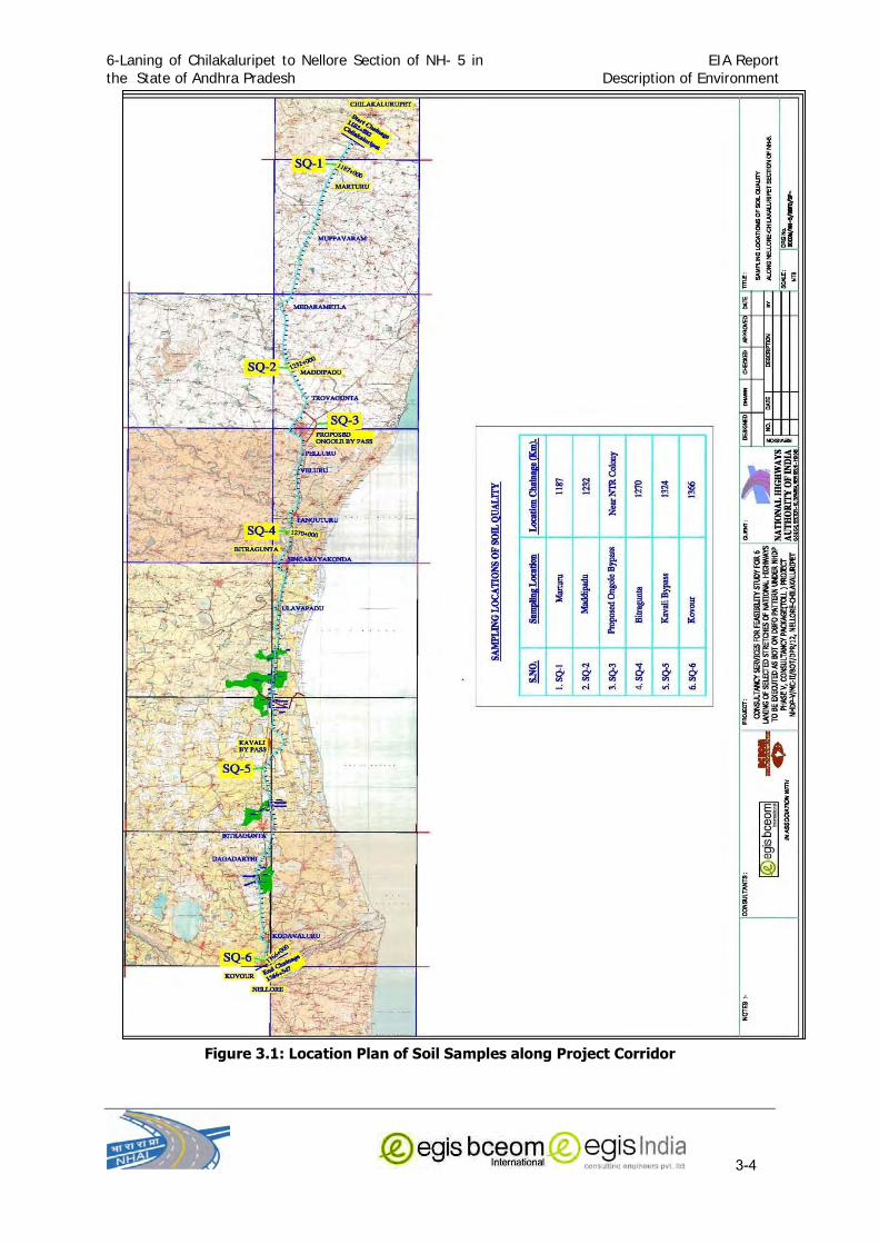
6-Laning of Chilakaluripet to Nellore Section of NH- 5 in
the State of Andhra Pradesh
EIA Report
Description of Environment
3-4
Figure 3.1: Location Plan of Soil Samples along Project Corridor

6-Laning of Chilakaluripet to Nellore Section of NH- 5 in
the State of Andhra Pradesh
EIA Report
Description of Environment
3-5
3.1.4 Quarry site and Borrow Areas:
Quarry areas
Road construction requires earth, stones and sand. These raw materials are to be obtained
from surrounding areas, which are suitable from quality point of view The stone materials
including sand and granular ones are needed in large quantities for the pavement
construction. The other area of requirement is concrete structures which call for a good
quality stone.
The potential source for stone aggregates, sand and gravels has been identified which is
depicted in Figure 3.2a, Figure 3.2b and Figure 3.2c. The Metal quarries are hill quarry or
flat land quarry and are devoid of any significant environmental features. Sufficient quantities
of metals are available in these quarries. Earth-Gravels quarries are located either over
hillocks or flat barren of unirrigated agricultural lands. Some vegetations can be seen over
these lands but these vegetations are mainly bushy and no significant species were observed
at these borrow sites. The sand quarries are mainly riverbed sand quarries.
Borrow Areas
The soils to be used, as sub-grade, select sub-grade and shoulder materials need to be
hauled from designated borrow areas. Similar to the identification of suitable quarries,
suitable borrow areas for supply of soil to the new road formation will be identified by
concessionaire during project implementation. Based on the total requirement and availability
of each soil type, estimates of soil quantity to be obtained from each of the borrow areas will
be worked out in accordance with the National Standards, recommended by the Indian Roads
Congress (IRC).
In the selection of the borrow areas, care will be taken to ensure that:
Sufficient quantity of suitable soil is available from the borrow pit;
The borrow areas are as close to the project road as far as possible;
The loss of productive and fertile agricultural soil is minimum; and
There is minimum loss of vegetation.
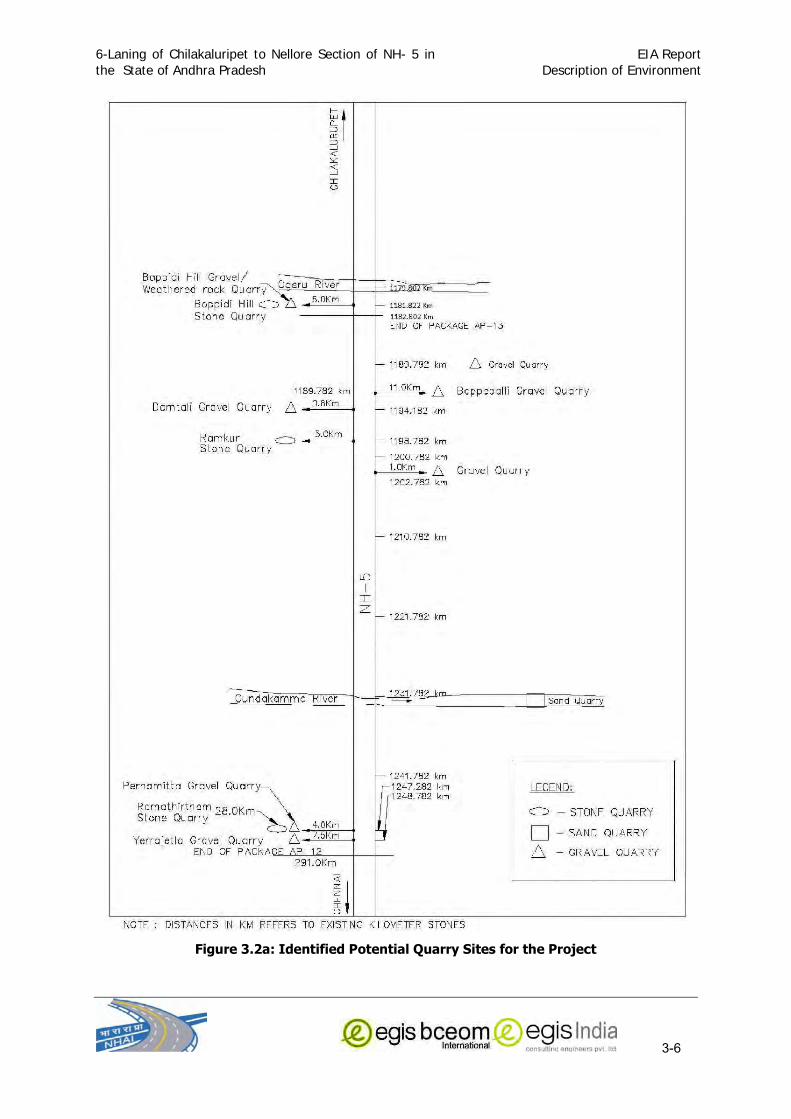
6-Laning of Chilakaluripet to Nellore Section of NH- 5 in
the State of Andhra Pradesh
EIA Report
Description of Environment
3-6
Figure 3.2a: Identified Potential Quarry Sites for the Project

6-Laning of Chilakaluripet to Nellore Section of NH- 5 in
the State of Andhra Pradesh
EIA Report
Description of Environment
3-7
Figure 3.2b: Identified Potential Quarry Sites for the Project

6-Laning of Chilakaluripet to Nellore Section of NH- 5 in
the State of Andhra Pradesh
EIA Report
Description of Environment
3-8
Figure 3.2c: Identified Potential Quarry Sites for the Project
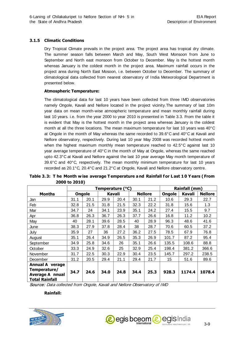
6-Laning of Chilakaluripet to Nellore Section of NH- 5 in
the State of Andhra Pradesh
EIA Report
Description of Environment
3-9
3.1.5 Climatic Conditions
Dry Tropical Climate prevails in the project area. The project area has tropical dry climate.
The summer season falls between March and May, South West Monsoon from June to
September and North east monsoon from October to December. May is the hottest month
whereas January is the coldest month in the project area. Maximum rainfall occurs in the
project area during North East Mosoon, i.e. between October to December. The summary of
climatological data collected from nearest observatory of India Meteorological Department is
presented below.
Atmospheric Temperature:
The climatological data for last 10 years have been collected from three IMD observatories
namely Ongole, Kavali and Nellore located in the project vicinity.The summary of last 10m
year data on mean month-wise atmospheric temperature and mean monthly rainfall during
last 10 years. i.e. from the year 2000 to year 2010 is presented in Table 3.3. From the table it
is evident that May is the hottest month in the project area whereas January is the coldest
month at all the three locations. The mean maximum temperature for last 10 years was 40°C
at Ongole in the month of May whereas the same recorded to 39.6°C and 40°C at Kavali and
Nellore observatory, respectively. During last 10 year May 2008 was recorded hottest month
when the highest maximum monthly mean temperature reached to 42.5°C against last 10
year average temperature of 40°C in the month of May at Ongole, whereas the same reached
upto 42.3°C at Kavali and Nellore against the last 10 year average May month temperature of
39.6°C and 40°C, respectively. The mean monthly minimum temperature for last 10 years
recorded as 20.1°C, 20.4°C and 21.2°C at Ongole, Kavali and Nellore observatory centre.
Table 3. 3: T he Month w ise average T emperature a nd Rainfall f or L ast 1 0 Y ears ( From 2000 to 2010)
Months Temperature (°C) Rainfall (mm)
Ongole Kavali Nellore Ongole Kavali Nellore Jan 31.1 20.1 29.9 20.4 30.1 21.2 10.6 29.3 22.7
Feb 32.8 21.5 31.8 21.5 32.3 22.2 31.8 15.6 1.3
Mar 34.7 24 34.1 23.9 35.1 24.2 27.4 15.5 9.7
Apr 36.8 26.3 36.7 26.3 37.7 26.6 16.8 11.2 10.2
May 40 28.1 39.6 28.5 40 28.9 96.3 48.6 41.6
June 38.3 27.9 37.8 28.4 38 28.7 70.6 60.5 37.2
July 35.9 27 36 27.2 36.2 27.5 78.5 67.9 76.8
August 35.1 26.4 34.9 26.5 35.3 26.9 101.7 87.2 95.4
September 34.9 25.8 34.6 26 35.1 26.6 135.5 108.6 88.8
October 33.3 24.9 32.6 25 32.9 25.4 198.4 381.2 366.6
November 31.7 22.5 30.3 22.9 30.4 23.5 145.7 297.2 238.5
December 31.2 20.5 29.4 21.1 29.4 21.7 15 51.6 89.6
Annual A verage Temperature/ Average A nnual Total Rainfall
34.7 24.6 34.0 24.8 34.4 25.3 928.3 1174.4 1078.4
Source: Data collected from Ongole, Kavali and Nellore Observatory of IMD
Rainfall:

6-Laning of Chilakaluripet to Nellore Section of NH- 5 in
the State of Andhra Pradesh
EIA Report
Description of Environment
3-10
The rainfall found to be erratic as at different years for last 10 years. The annual rainfall
varied greatly from 755.1 mm in the year 2000-2001 to 1357 mm in the year 2001-2002
against normal rainfall of 1140 mm at Nellore (Figure 3.3). The same varies between 706.2
mm and 1526.9 mm against normal annual rainfall of 1194 mm at Kavali. At Nellore the
annual rainfall recorded between 553.9 mm to 1467 mm against normal annual rainfall of
1085 mm. The precipitation in the project area occurs both due to South West Monsoon from
June to September and North east monsoon from October to December. More than 60
percent rainfall is recorded due to North East Monsoon, which starts from October and extend
upto December in the entire project area. From the above Table 3.3, it is evident that the last
10 year mean annual rainfall was recorded maximum in Kavali (1174.4 mm) followed by
Nellore (1078.4) and lowest in Ongole (928.3 mm).
Figure 3.3: Variation in Annual Rainfall at different Places along Project Area during last 10 Years

6-Laning of Chilakaluripet to Nellore Section of NH- 5 in
the State of Andhra Pradesh
EIA Report
Description of Environment
3-11
Source: IMD, Hyderabad
Wind Pattern:
The wind direction has different pattern in the project area during morning and evening
hours. It also varies with months. At Nellore the predominant wind direction during morning
hours is NW in the month of January, SSE during February, March and April, in May and June
it changes to West. In the month of July and August the wind direction is usually from West
South West (WSW) whereas the same changes to from West North West (WNW) in the
months of September & October. During November and December the wind blows from
North West (NW).
During Evening time from North North East (NNE) direction, in February to April from East
South East (ESE) direction, West South West (WSW), July August West (W), September to
December from North East (NE).
The wind speed is moderate with an average speed ranging from 1-19 Km per hours
In Ongole the predominant wind direction during morning hours is from South West to North
East direction During February to October whereas During January, November and December
the predominant wind direction is from North to South. In the evening time the predominant
direction is from South East during the months of January to May which changes to from
South West to North East Direction. In the month of October to December the same again
changes to from North East to South West Direction. The Calms (in percentage frequencies)
during the day for the month of January, February, March, April & May is 34%, 40%, 24%,
13% & 13% respectively; however, during the night for the month of January, February,
March, April & May is 3 %, 1%, 8%, 8% and 3% respectively The Calms (in percentage
frequencies) during the day for the month of June, July, August, September & October is 6%,
9%, 7%, 24% & 36% respectively; however, during the night for the month of June, July,
August, September & October is 5%, 6%, 8%, 12% and 20% respectively. The Calms (in
percentage frequencies) for the month of Nov & Dec during the day is 21% & 22%
respectively and during the night for the month of Nov & Dec is 15 and 5% respectively.
ONGOLE

6-Laning of Chilakaluripet to Nellore Section of NH- 5 in
the State of Andhra Pradesh
EIA Report
Description of Environment
3-12
Relative Humidity:
Being a coastal districts, all the three districts experience high relative humidity throughout
the year., Most of the time the relative humidity is found in the range more than 70% except
in the months of May, June and July when relative humidity is between 60% to 70% in the
morning hours at all the three observatory, i.e at Ongole, Kavali and Nellore. However in the
evening hours slight reduction in relative humidity if observed but still it ranges from 52% to
75% most of the time in a year.
Micro-metrology at Ongole:
To collect site-specific meteorological data like maximum and minimum temperature, rainfall,
humidity, wind speed and wind direction, a wireless Data logger weather monitoring station
was installed at project site at Ongole town and the data was collected from 6th January,
2011 to 5th February, 2011. The maximum temperature recorded was 310 C on where as the
minimum temperature recorded was 310 C. No rainfall occurred during the study period. The
predominant wind direction during the monitored period was from South-West to North-East.
The maximum wind speed monitored was 8.64 Km/hr. The frequency of calm wind was
0.13%. The summary of the results of meteorological data collected at site are given in
Annexure 3.3 and Wind Rose Diagram of the area was prepared based on the site data and
is shown in Figure 3.4.
Figure 3.4: Wind rose Diagram at Ongole

6-Laning of Chilakaluripet to Nellore Section of NH- 5 in
the State of Andhra Pradesh
EIA Report
Description of Environment
3-13
3.1.6 Land Use Pattern
As per the statistics of Irrigation and Command Area Development Department, Government of
Andhra Pradesh presented in Table 3.4 shows that, in Guntur district out of the total area of
27.99 lakh acres around 56% constitute cultivable land, forest land (14.30%), barren and
uncultivable area (3.04%) and land put to non-agricultural use is about 13.24%. In Prakasam
district out of the total area of 42.35 lakh acres around 52% constitute cultivable land, forest
land (25.82%), barren and uncultivable area (8.8%) and land put to non-agricultural use is
about 13%.
Table 3.4: Land use pattern in Guntur, Prakasam and Nellore Districts
Description
Guntur Prakasam Nellore
Area (Acres)
% to total area
Area (Acres)
% to total area
Area (Acres)
% to total area
Total Geographical
Area 27,99,264 --- 42,35,530 --- 32,52,006 ---
Cultivable Area 15,67,614 56.00 22,16,571 52.33
Forest Area 4,00,163 14.30 10,93,684 25.82 6,48,597 19.94
Barren & Un Cultivable
Area 85,178 3.04 3,72,849 8.80
Land put to Non-
Agricultural purpose 3,70,643 13.24 5,52,426 13.04 5,33,832 16.42
Sown Area 13,41,845 47.94 15,14,272 35.75
Irrigated Area 6,78,197 24.23 10,78,369 25.46 7,88,386 24.24
Source: Primary Census Abstract, Census of India, 2001, Handbook of Statistics, Prakasam 2006,
National Informatics Centre, Nellore district website
Along the project corridor also the predominant land use is agriculture which accounts for
about 52 % considering the entire project stretch, whereas land use along the project section
in Guntur district, which is only 1.079 Kms, is only agriculture whereas the same in the stretch
falling under Prakasam and Nellore district boundary is about 51% each. The land use pattern
along the Right of Way of the project stretch is depicted in Figure 3.5 and ANNEXURE-3.4
The superimposition of Land use pattern, environmental features and drainage pattern data
along the highway section in 10 Km radius over satellite imagery collected from NRSA,
Hyderabad and Survey of India Toposheet is presented in Annexure 3.5.

6-Laning of Chilakaluripet to Nellore Section of NH- 5 in
the State of Andhra Pradesh
EIA Report
Description of Environment
3-14
3.1.7 Surface Water Resource:
The terrain along the Project Highway is fairly level with gently rolling terrain up to north end
of the project highway. Due to the presence of eastern Ghat, a number of streams, nallas and
rivers originate and flow in the easterly direction ultimately discharging along the Bay of Bengal
(Coromandel Coast). The drainage pattern in the project area is depicted in Annexure 3.5 and
Annexure 3.6.
The project road crosses rivers, nallas, local streams and canals. The major rivers which project
crosses are Mudigundi , Musi, Paleru, Maneru and Pyderu. All these rivers and streams are
rainfed. The chainages of the river, canal, nalla crossings are given below in Table 3.5. Apart
from these rivers and Canals a number of local streams and nallah flows in the area which are
shallow and are active during monsoon. Some of the rivers and streams have been harnessed
by constructing dams and barrages which in-turn supply water through a network of canals.
Table 3.5: River and Canals crossing the project section
S. No. River/Stream Name
Chainage KM Remark
A. Guntur District 1 Palamadugu Nalla 1183.279 Rain fed Major Nalla
B. Prakasam District
2 Gundalakamma River
1229.025 Rain fed Major River
3 Mudigandi River 1240.357 Rain fed Major River
4 Nalla 1261.320 Rain fed Major Nalla
5 Musi River 1261.810 Rain fed Major River
Figure 3.5: Land Use Pattern along Project Alignment

6-Laning of Chilakaluripet to Nellore Section of NH- 5 in
the State of Andhra Pradesh
EIA Report
Description of Environment
3-15
S. No. River/Stream Name
Chainage KM Remark
6 Drain 1262.950 Rain fed Major Nalla
7 Palleru River 1269.150 Rain fed Major River
8 Maneru River 1282.680 Rain fed Major River
9 Chillavagu 1286.220 Rain fed Major Nalla
C. Nellore District 10 Pillavagu Canal 1327.835 Rain fed Major Nalla
11 Pyderu Canal 1355.150 Rain fed Major Nalla
Source: Primary Data
The area along the project corridor is dotted with a number of The ponds / tanks and
reservoirs all along the project stretch. These ponds and reservoirs are mainly used for
irrigation purpose and some of the ponds and reservoirs are used for fishery. Some of the
Ponds fall within the proposed ROW may need to be partially filled for road formation. The
list of such ponds and reservoirs has been presented in Table 3.6.
Table 3.6: Ponds / Tanks within Corridor of Impact Project Road
Sl No
Type of Resources
Name of Tank
Chainage in Km.(From - To)
Place Direction (RHS/LHS)
A. GUNTUR DISTRICT
Nil B. PRAKASAM DISTRICT 1 Pond 1222+700 to 1222+800 Timmanapalem RHS
2 Tank 1222+850 to 1223+100 Timmanapalem RHS
3 Tank 1236+100 to 1236+240 Venkatarajupalem RHS
4 Tank 1238+360 to 1238+460 Yedugundlapadu RHS
5 Water Logged
area
1241+300 to 1241+400 Muktinutalapadu RHS
6 Reservoir Vallurumma tank
1253+490 to 1253+950, 1254+480
to 1254+600,
1255+650 to 1256.35 & 1256+700 to 1257+100
Pelluru & Valloru RHS
7 Tank 1268+130 to 1268+170 Vaviletipadu RHS
8 Tank 1268+250 to 1268+320 Vaviletipadu RHS
9 Tank 1268+630 to 1268+780 Vaviletipadu RHS
10 Tank Vora
Cheruvu
1281+530 to
1281+800
Singarayakonda RHS
11 Pond Kollurupadu tank
1288+000 to 1288+100 Kollurupadu LHS
12 Pond 1292+070 to 1292+500 Rajupalem RHS
13 Pond 1292+330 to 1292+580 Rajupalem LHS
14 Pond 1293+340 to 1293+370 Rajupalem LHS
15 Tank 1301+400 to 1301+920 Tettu RHS
16 Tank Mocherla Tank
1304+540 to 1304+580 Mocherla RHS

6-Laning of Chilakaluripet to Nellore Section of NH- 5 in
the State of Andhra Pradesh
EIA Report
Description of Environment
3-16
Sl No
Type of Resources
Name of Tank
Chainage in Km.(From - To)
Place Direction (RHS/LHS)
C. NELLORE DISTRICT 17 Reservoir Jutur
Reservoir
1319+350 to
1320+770
Amudaladinne Both side
18 Tank 1324+270 to 1324+370 Musunuru LHS
19 Tank 1330+200 to 1330+260 Gawravaram RHS
20 Tank 1332+420 to 1332+470 Bitragunta LHS
21 Tank 1332+920 to 1332+960 Bitragunta RHS
22 Tank 1333+900 to 1334+500 Kadanutala RHS
23 Tank 1334+300 to 1334+400 Kovurupalli LHS
24 Tank 1342+860 to 1342+900 Lions Nagar RHS
25 Tank 1349+470 to 1349+520 Kothapalli Kavuru
Gunta
LHS
26 Tank 1349+450 to 1349+730 Kothapalli Kavuru Gunta
RHS
27 Tank 1352+030 to 1352+050 Gopalapuram RHS
28 Tank 1352+240 to 1352+270 Gopalapuram RHS
29 Tank 1352+390 to 1352+480 Gopalapuram RHS
30 Tank 1352+860 to 1352+910 Gopalapuram RHS
31 Tank 1357+000 to 1357+220 Nayudupalem LHS
32 Tank 1364+460 to 1364+540 Nandalagunta RHS
Source: Primary Data
Surface Water Quality
Pre-monsoon surface water samples were taken from 6 locations along the project corridor in
the month of January, 2011 for assessing the surface water quality within the project area.
The surface water samples were from River, Pond, Canal & Water tanks along the project
road. The sampling locations for surface water are given in Table 3.7 and Figure 3.6. The
test results of physic-chemical and bacteriological characteristics of the surface water samples
are presented in Table 3.8.
Table 3.7: Surface Water sampling location Sl Locations Location
Chainage (Km)
Date of Sampling
Distance from NH-5
(meter)
Description of Site
1 Gundalakamma 1228+200 11.01.2011 25 Residential Cum Commercial Area
2 Musi River 1262+950 11.01.2011 50 Agriculture Land
3 Proposed Ongole Bypass
Near NTR Colony
10.01.2011 2500 Agriculture Land
4 Water Tank at
Musuru Village
1323+000 10.01.2011 30 Agriculture Land
5 Water Tank at
Dagadarthi Village
1342+000 10.01.2011 20 Agriculture Land
6 Pydlerilli Canal 1355+150 10.01.2011 20 Agriculture Land

6-Laning of Chilakaluripet to Nellore Section of NH- 5 in
the State of Andhra Pradesh
EIA Report
Description of Environment
3-17
Figure: 3.6 Surface and Ground Water Sampling Locations

6-Laning of Chilakaluripet to Nellore Section of NH- 5 in
the State of Andhra Pradesh
EIA Report
Description of Environment
3-18
Table 3.8: SURFACE WATER QUALITY RESULTS Sl
No. Water Quality
Parameters
LOCATIONS SW-1 SW-2 SW-3 SW-4 SW-5 SW-6
Gandalakamma Musi River
Proposed Ongole Bypass
Water Tank a t Musuru Village
Water Tank a t Dagadarthi Village
Pydlerili Canal
1. pH ( at 280 C) 8.07 7.32 7.64 7.49 7.56 7.39
2. Conductivity at
250C in ms/cm
482 750 730 804 182 482
3. Total Suspended Solid (TSS) in
mg/L
6 8 2 4 4 8
4. Total Dissolved Solids in mg/L
304 472 458 506 114 304
5. Total Hardness
(as CaCO3) in mg/L
152 164 248 140 52 108
6. Dissolved Oxygen in mg/L
7.0 7.8 7.1 7.5 7.8 7.3
7. Biochemical
Oxygen Demand (for 3 days at 270
C) in mg/L
0.80 1.70 1.2 1.40 1.60 2.90
8. Chemical Oxygen Demand in mg/L
2.4 5.30 3.78 4.20 4.70 8.80
9. Chloride as Cl in
mg/L
115.85 45.77 75.96 262.18 36.50 118.89
10. Sulphate (as SO4)
in mg/L
43.33 14.78 15.23 17.87 16.81 21.66
11. TKN mg/L ND ND ND ND ND ND
12. Nitrate (as NO3) in mg/L
0.20 0.67 0.76 0.13 0.32 0.06
13. Iron (as Fe) in mg/L
0.19 0.32 0.24 0.18 0.14 0.22
14. Cadmium (as Cd)
in mg/L
<0.01 <0.01 <0.01 <0.01 <0.01 <0.01
15. Chromium (as Cr) in mg/L
<0.01 <0.01 <0.01 <0.01 <0.01 <0.01
16. Copper (as Cu) in mg/L
<0.01 <0.01 <0.01 <0.01 <0.01 <0.01
17. Mercury (as Hg)
in mg/L
<0.01 <0.01 <0.01 <0.01 <0.01 <0.01
18. Lead (as Pb) in mg/L
<0.01 <0.01 <0.01 <0.01 <0.01 <0.01
19. Zinc (as Zn) in mg/L
<0.01 <0.01 <0.01 <0.01 <0.01 <0.01
20. Fluoride (as F) in
mg/L
1.45 0.45 0.34 0.82 0.23 1.15
21. Oil & Grease in mg/L
Nil Nil Nil Nil Nil Nil
22. Phenolic <0.01 <0.01 <0.01 <0.01 <0.01 <0.01

6-Laning of Chilakaluripet to Nellore Section of NH- 5 in
the State of Andhra Pradesh
EIA Report
Description of Environment
3-19
Sl No.
Water Quality Parameters
LOCATIONS SW-1 SW-2 SW-3 SW-4 SW-5 SW-6
Gandalakamma Musi River
Proposed Ongole Bypass
Water Tank a t Musuru Village
Water Tank a t Dagadarthi Village
Pydlerili Canal
Compounds in mg/L
23. Detergent(as
MBAS),mg/l
<0.01 <0.01 <0.01 <0.01 <0.01 <0.01
24. Phosaphate as
PO4 in mg/L
Nil Nil Nil Nil Nil Nil
25. Total Coliform Organism
(MPN)/100 ml
<2.0 <2.0 <2.0 <2.0 <2.0 <2.0
26. Faecal Coliforms / 100 ml
Absent Absent Absent Absent Absent Absent
The analysis result indicates that all the surface water bodies from which the water samples
were taken meet the quality criteria for Class C (Drinking water source after conventional
treatment and disinfection) and Class D (Propagation of Wildlife and Fisheries) of surface
water. The pH, Dissolve Oxygen (DO), Biological Oxygen Demand (BOD) for all the locations
along the project road is within permissible limits. The pH is varying from 7.32 to 8.07,
Dissolve Oxygen is varying from 7.0 mg/l to 7.8 mg/l and Biological Oxygen Demand (BOD)
ranged from 0.80 mg/l to 2.90 mg/l. The Fluoride (as F) in mg/l is varying from 0.23 mg/l to
1.45 mg/l along the project road. The water samples of Gandalakamma and Pydlerili canals
showed higher Fluoride content 1.45 mg/l, and 1.15 mg/l respectively, which is more than the
desirable limit of 1.0 mg/l.
3.1.8 Groundwater Sources
The water table varies between 8 m to 20 m in the project area. There are some ground
water resources identified in the project corridor. Groundwater resources consists of bore
wells, tube wells, hand pumps and these are mainly used for irrigation, drinking, domestic
and commercial purposes. The list of hand pumps, which fall along proposed ROW and are
likely to be affected, is attached at Annexure 3.6. Keeping in view the importance of ground
water, four ground water samples were taken for physico-chemical analysis along the project
road. The details of ground water sampling locations are given in Table 3.9 the indicative
map of ground water sampling locations is presented in Figure 3.6.
Table 3.9: Ground Water sampling locations
S.N.l Location Name Location Chainage
(Km)
Date of Sampling
Distance from NH-5
(meter)
Type of Source
1 Marturu 1187 11.01.2011 20 Borewell 2 Muppavaram 1205 11.01.2011 10 Borewell
3 Trovagunta 1240 11.01.2011 10 Borewell
4 Proposed Ongole
Bypass
Near NTR
Colony
10.01.2011 2400 Hand Pump
5 Kavali Bypass 1324 10.01.2011 15 Hand Pump
6 Kovour 1366 10.01.2011 30 Borewell

6-Laning of Chilakaluripet to Nellore Section of NH- 5 in
the State of Andhra Pradesh
EIA Report
Description of Environment
3-20
The pH along the project road for all the locations is within permissible limit. The Total dissolve solid
is varying from 214 to 960 mg/l for different locations along the project road. At three locations such
as Marture, Bitragunta and Maddipadu, the Dissolve Solid is 960 mg/l, 830 mg/l and 718 mg/l
respectively, which is more than the desirable limit as per IS:10,500 is 500 mg/l. The Total hardness
(as CaCO3) in mg/l is ranging from 136 to 328 mg/l for different locations along the project road. At
Maddipadu, the Total hardness is 328 mg/l, which is more than the desirable limit of 300 mg/ l as per
IS: 10,500. The Fluoride (as F) in mg/l is varying from 0.45 mg/l to 1.93 mg/l along the project road.
At three locations such as Marture, Proposed Ongole bypass and Kovour, the Fluoride is 1.93 mg/l,
1.45 mg/l and 1.16 mg/l respectively, which is more than the desirable limit as per IS:10,500 is <1.0
mg/l after disinfection. The other heavy are within desirable limits. The results of ground water
quality are given in Table 3.10.
Table 3.10: GROUND WATER QUALITY RESULTS Sl
No. Water Quality
Parameters LOCATIONS
GW-1 (Marturu)
GW-2 (Maddipadu)
GW-3 (Proposed
Ongole Bypass)
GW-4 (Bitragunta)
GW-5 (Kavali Bypass)
GW-6 (Kovour)
1. pH ( at 280 C) 7.40 7.02 7.93 7.99 7.20 8.16
2. Conductivity at 250C in ms/cm
1526 1140 492 1318 340 578
3. Total Suspended
Solid (TSS) in mg/L
5 6 4 6 4 2
4. Total Dissolved
Solids in mg/L
960 718 310 830 214 364
5. Total Hardness (as
CaCO3) in mg/L
172 328 144 300 168 136
6. Dissolved Oxygen in mg/L
7.1 7.6 7.1 7.1 7.1 7.2
7. Biochemical
Oxygen Demand (for 3 days at 270
C) in mg/L
0.40 0.30 0.30 0.40 0.30 0.20
8. Chemical Oxygen
Demand in mg/L
1.6 1.2 1.2 1.6 1.2 1.0
9. Chloride as Cl in mg/L
442.06 298.77 109.75 298.77 100.60 121.94
10. Sulphate (as SO4)
in mg/L
27.12 68.02 38.78 92.27 23.78 38.48
11. TKN mg/L ND ND ND ND ND ND
12. Nitrate (as NO3) in
mg/L
0.30 0.45 0.65 0.72 0.38 0.53
13. Iron (as Fe) in mg/L
0.26 0.26 0.28 0.18 0.17 0.14
14. Cadmium (as Cd) in mg/L
<0.01 <0.01 <0.01 <0.01 <0.01 <0.01
15. Chromium (as Cr)
in mg/L
<0.01 <0.01 <0.01 <0.01 <0.01 <0.01
16. Copper (as Cu) in mg/L
<0.01 <0.01 <0.01 <0.01 <0.01 <0.01
17. Mercury (as Hg) in mg/L
<0.01 <0.01 <0.01 <0.01 <0.01 <0.01

6-Laning of Chilakaluripet to Nellore Section of NH- 5 in
the State of Andhra Pradesh
EIA Report
Description of Environment
3-21
Sl No.
Water Quality Parameters
LOCATIONS GW-1
(Marturu) GW-2
(Maddipadu) GW-3
(Proposed Ongole Bypass)
GW-4 (Bitragunta)
GW-5 (Kavali Bypass)
GW-6 (Kovour)
18. Lead (as Pb) in
mg/L
<0.01 <0.01 <0.01 <0.01 <0.01 <0.01
19. Zinc (as Zn) in
mg/L
<0.01 <0.01 <0.01 <0.01 <0.01 <0.01
20. Fluoride (as F) in mg/L
1.93 0.45 1.45 0.68 0.49 1.16
21. Oil & Grease in
mg/L
Nil Nil Nil Nil Nil Nil
22. Phenolic
Compounds in mg/L
<0.01 <0.01 <0.01 <0.01 <0.01 <0.01
23. Detergent(as
MBAS),mg/l
<0.01 <0.01 <0.01 <0.01 <0.01 <0.01
24. Phosaphate as PO4
in mg/L Nil Nil Nil Nil Nil Nil
25. Total Coliform Organism
(MPN)/100 ml
<2.0 <2.0 <2.0 <2.0 <2.0 <2.0
26. Faecal Coliforms / 100 ml
Absent Absent Absent Absent Absent Absent
Source: Primary data collection
3.1.9 Ambient Air Quality:
To study the baseline ambient air quality scenario within the project corridor the ambient air
quality was monitored at seven locations in the month of December, 2010 February 2011. The
monitoring stations were selected considering the spatial relationship of various land uses
along the project road, and CPCB guidelines. The details of Sampling Location are presented in
Table 3.11 and Figure 3.7.
Table 3.11: Sampling Locations of Ambient Air Quality along the Project Corridor Sl. No
Sampling Location Traffic Section Location Chainage
(Km)
Coordinates (N)
Coordinates (E)
01 Marturu (25 mts. from NH-5) AAQ1
Chilakaluripet - Medarametla
1187 N15059’14.1” E080006’15.7”
02 Muppavaram AAQ6 Chilakaluripet -
Medarametla
1205 N15050’47.6” E080003’05.7”
03 Maddipadu AAQ5 Medarametla –
Ongole
1232 N15037’14.4” E080001’17.4”
04 Proposed Ongole Bypass AAQ4
Medarametla – Ongole
Near NTR Colony
N15029’49.7” E080004’06.2”
05 Bitragunta AAQ3 Kavali - Nellore 1270 N15018’32.2” E080001’41.2”
06 Kavali Bypass AAQ2 Kavali - Nellore 1324 N14052’23.4” E079059’11.1”
07 Kovour AAQ1 Kavali - Nellore 1366 N14030’33.5” E079059’13.6”

6-Laning of Chilakaluripet to Nellore Section of NH- 5 in
the State of Andhra Pradesh
EIA Report
Description of Environment
3-22
Table 3 .12: Ambient A ir Quality a long Chilakluripet to Nellore section NH-5 at D ifferent
Locations Monitoring
Station Code
Location Chainage (Km)
Place Concentrations of Air Quality Parameters
SPM (µgm-3)
PM10
(µgm-
3)
PM2.5 (µgm-
3)
SO2 (µgm-3)
NO2 (µgm-
3)
CO (mgm-
3) A. PRAKASAM DISTRICT
AAQ-1 1187 Marturu 201 96 48 6 22.2 1.12
AAQ-2 1205 Muppavaram 215 97 48 6.6 16.1 1.03
AAQ-3 1232 Maddipadu 191 94 52 6.6 23.9 1.1
AAQ-4
Near NTR Colony
Ongole Bypass
220 107 47 <5 16.10 1.02
AAQ-5 1270 Bitragunta 193 89 49 6 25 1.16
B. NELLORE DISTRICT AAQ-6 1324 Kavali Bypass 213 96 53 6 23.2 1.15
AAQ-7 1366 Kovur 215 93 51 5.7 25.1 1.07
AAQ
Standards
- 100 60 80 80 2.0

6-Laning of Chilakaluripet to Nellore Section of NH- 5 in
the State of Andhra Pradesh
EIA Report
Description of Environment
3-23
Figure 3.7: Sampling Location of Ambient Air Quality

6-Laning of Chilakaluripet to Nellore Section of NH- 5 in
the State of Andhra Pradesh
EIA Report
Description of Environment
3-24
The average Suspended Particulate Manner (SPM) concentration in the air varied between
191µgm-3 and 220µgm-3 during the study period. The concentration of Particulate Matters
having less than 10µ size (PM10) in the ambient air varied between 89 µgm-3 to 107 µgm-3
whereas the concentration of PM2.5 in the air ranged between 47 µgm-3 and 53 µgm-3. The
dryness of the areas, semi arid conditions and loose dust particles along the project corridor
caused higher concentration of PM10 and PM2.5. The other gaseous pollutants monitored in the
ambient air were well within the National Ambient Air Quality Standard at all the locations.
3.1.10 Ambient Noise Level:
Noise monitoring was carried out at different locations along the project road to understand the
present scenario of noise pollution along the project section. Ten numbers of noise monitoring
locations covering different types of environmental setting such as educational institutions
religious place, residential and commercial locations along the project road has been identified
for ambient noise monitoring. The noise monitoring locations along the project road are given
in Table 3.13 and same is given in Figure 3.8.
Table 3.13: Noise Monitoring Locations along the project road
Station Code
Monitoring Location
Machine location
Chainage (Km)
Date of Sampling
Type of Area Distance from (NH5) (meter)
N-1 Marturu Near Primary
School
1187 18/01/11 to
19/01/11
Residential Cum
Commercial
20
N-2 Narnevaaripalem Near Temple 1202+50 18/01/11 to 19/01/11
Residential Cum Commercial
15
N-3 Muppavaram Near Govt.
Hospital
1205 27/01/11 to
28/01/11
Residential Cum
Commercial
18
N-4 Maddipadu Near Residential
Colony
1232 27/01/11 to
28/01/11
Residential Cum
Commercial
20
N-5 Trovagunta Near Residential Colony
1240 25/01/11 to 26/01/11
Residential Cum Commercial
15
N-6 Proposed Ongole
Bypass
NTR Colony Proposed
Ongole Bypass
25/01/11 to
26/01/11
Residential Area 2500
N-7 Pelluru Near Sai School 1252+50 20/01/11 to
21/01/11
Commercial Area
10
N-8 Velluru Near College 1256+35 20/01/11 to
21/01/11
Mixed use 10
N-9 Kavali By Pass Near College 1324 18/01/11 to 19/01/11
Mixed use 15
N-10 Kovour Near Temple 1366 18/01/11 to
19/01/11
Commercial Area
15
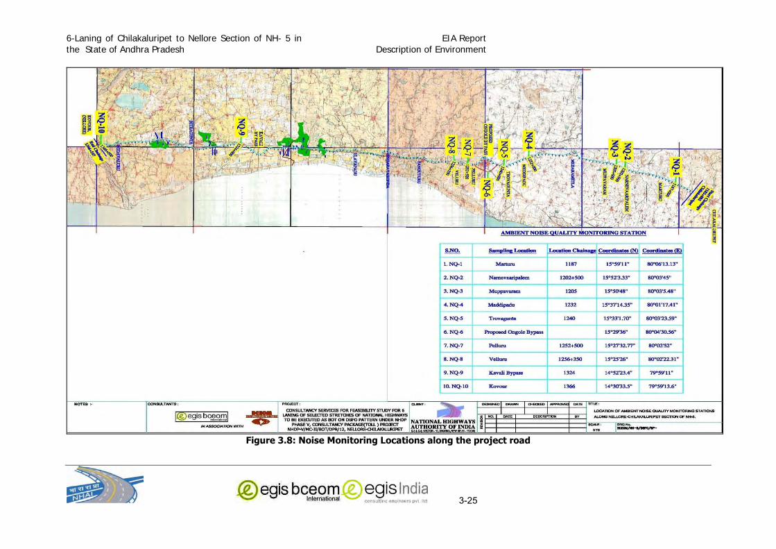
6-Laning of Chilakaluripet to Nellore Section of NH- 5 in
the State of Andhra Pradesh
EIA Report
Description of Environment
3-25
Figure 3.8: Noise Monitoring Locations along the project road

6-Laning of Chilakaluripet to Nellore Section of NH- 5 in
the State of Andhra Pradesh
EIA Report
Description of Environment
3-26
The finding of the Noise level monitoring is presented in Table 3.14. The noise monitoring has been
carried out ranging from 10 meters to 20 meter distance from National Highway except proposed
Ongole bypass. The distance of noise monitoring from proposed Ongole bypass is 2.5 km. The noise
monitoring result at Marturu (Near Primary School), Narnevaaripalem (Near Temple), Muppavaram
(Near Govt. Hospital), Pelluru (Near Sai School), Velluru (Near College) and Kovour (Near Temple) are
at higher value during day and night time as compared to standards of silence zone, due to mix
category of areas. The noise monitoring result at Maddipadu (Near Residential Colony) and Proposed
Ongole Bypass are within permissible limits during day and night time. The noise monitoring results at
different locations along the project road are given in Table 3.14.
Table 3.14: Ambient Noise Level at different Location along Project Corridor Station Code
Monitoring Location
Chainage (Km)
Distance from (NH5) (meter)
Mean Day time Leq
dB(A)
Mean Night
Time Leq dB(A)
Lmax dB(A)
Lmin dB(A)
N-1 Marturu (Near
Primary School)
1187 20 65.8 53.3 71.0 47.3
N-2 Narnevaaripalem (Near Temple)
1202+50 15 60.4 54.3 64.7 44.5
N-3 Muppavaram (Near
Govt. Hospital)
1205 18 58.0 50.3 69.0 41.4
N-4 Maddipadu (Near
Residential Colony)
1232 20 55.0 42.8 63.0 38.0
N-5 Trovagunta (Near Residential Colony)
1240 15 65.5 56.6 74.0 35.6
N-6 Proposed Ongole
Bypass
2500 50.6 40.3 63.0 31.0
N-7 Pelluru (Near Sai
School)
1252+50 10 57.9 48.8 74.2 47.6
N-8 Velluru (Near College)
1256+35 10
66.5 57.5 79.3 43.2
N-9 Kavali By Pass
(Near College)
1324 15 55.3 48.9 62.3 42.3
N-10 Kovour (Near Temple)
1366 15 60.5 49.5 72.0 42.0
Source: Primary data collection
3.2 Ecological Resources:
3.2.1 Forest Area
The project area is devoid of any significant vegetation of forests. The district wise forest
coverage is low. Among the three concern district Prakasam has only 17.61 % forest
coverage to its total geographical area, whereas Nellore has only 7.17% of its geographical
area under forest. Guntur has as low as 7.58 % of its area under forest coverage (Table 3.15). Figure 3 .9 depicts that in all the three costal districts of Nellore, Prakasam and
Gunture have forest far away from the project area.
spatial extent of potential impacts on human health and natural and manmade resources. In
the present case, the proposed highway is more than 30 Kms in length. At several locations
(entry and exit points; rest areas and at toll plaza) the land acquisitions is more than 20 m. The
proposed Ongole bypass is having a length of Hence, as per EIA notification 2006, the

6-Laning of Chilakaluripet to Nellore Section of NH- 5 in
the State of Andhra Pradesh
EIA Report
Description of Environment
3-27
proposed project falls under Category A and attracts the conditions of obtaining prior
Environmental Clearance from Ministry of Environment and Forests (MoEF).
Table 3 .15: District-wise Fo rest C overage ( in sq Km ) (Source Andhra Pradesh
Forest Statistics, 2007) District Geographical
Area Very
Dense Forest
Moderately Dense Forest
Open Forest
Total % of Geographical
area Guntur 11,391 0 219 644 863 7.58
Prakasam 17,626 172 1,342 1,590 3,104 17.61
Nellore 13,076 5 261 671 937 7.17
Andhra Pradesh
Total
2,75,069 820 24,757 19,525 45,102 16.4
Figure 3.9: Forest Coverage in Andhra Pradesh
Along the project corridor open bushy vegetation are situated. There are some pockets of
Reserved Forests located in closed vicinity and some are extended within the proposed right
of way, hence are likely to be affected and diversion of forest area will be required. Some
plantation of Eucalyptus and Babool plantation has been carried out in these forest areas.
The list of Reserve Forest area falling within the proposed ROW is presented in Table 3.16.
Table 3.16: Reserve Forest within Corridor of Impact Forest Section Chianage (Km)
Length (Km) From To A. Guntur District
Nil Nil Nil
B. Prakasam District Mocherla R.F. 1297.8 1299.2 1.4
Mocherla R.F. 1297.8 1299.2 1.4

6-Laning of Chilakaluripet to Nellore Section of NH- 5 in
the State of Andhra Pradesh
EIA Report
Description of Environment
3-28
Forest Section Chianage (Km) Length (Km) From To
Ravuru RF 1302.6 1303.6 1
Mocherla Chalamcharla RF 1302.7 1303.6 0.9
Cheveru 1303.65 1304.2 0.55
Cheveru 1303.65 1304.3 0.65
Cheveru 1305.45 1305.46 0.01
Cheveru R.F. 1306.5 1307.9 1.4
Total 7.31 C. Nellore District
Rudrakota, R.F. 1307.9 1309.4 1.5
Gawravaram, R.F. 1331.5 1332.2 0.7
Allimadugu Bogole 1332.09 1332.1 0.01
Kothapali Kavuru Gunta R.F. 1347.19 1348.5 1.31
3.52
3.2.2 Ecologically Protected Area:
There is no any National Park, Wildlife Sanctuary, Tiger Reserves, notified ecologically sensitive
area, or any other significant area of ecological interest situated within 15 Km radius except for
reserved forest areas. No endangered or protective species reported from the project area.
3.2.3 Roadside Tree Plantation:
A total number of 32506 trees of varying girth are located within the corridor of impact and are
likely to be felled due to the project. Out of these, a total number of 273 trees will required to
be cut in the district Guntur, 25144 from Prakasam District and rest 7089 in Nellore district.
The average distance of the tree rows from the edges of the existing carriageway varied
between 5 m to 8 m. The baseline studies showed that there is no any endangered or
protected tree species located within the project area. The predominant tree species to be
felled include Gulmohar (Delonix regia), Neem (Azadirachta indica), Imli (Tamarindus indica),
Acacia auriculiformis and Albizzia.lebbeck (Kala Siris) and rest are having mainly ornamental &
firewood. These are all ubiquitous species.
Table 3.17: Tree Species along Roadside S.No. Common Name Botanical Name 1. Palm Barassus flabellitor 2. Coconut Cocus nucifera 3. Siris Albezia lebbeck 4. Gulmohar Delonix regia 5. Banyan Ficus benghalensis 6. Peepal Ficus religiosa 7. Tamarind Tamarindus Indica 8. Mango Magnifera Indica 9. Ashoka Polyalthia longitolia 10. Acasia auriculiformis Acasia auriculiformis 10. Eucalyptus Eucalyptus sp. 11. Akashmani - 12. Neeru Azarichta Indica
The complete list of the trees species along with their girth size are presented in Annexure-3.7 and Annexure 3 .8 which are falling within the ROW in main alignment and Ongole
Bypass alignment, respectively.

6-Laning of Chilakaluripet to Nellore Section of NH- 5 in
the State of Andhra Pradesh
EIA Report
Description of Environment
3-29
3.2.4 Fauna
The faunal population along the project corridor is constituted by mainly domestic animal such
as cattles, goats, dogs, etc. The common birds observed in the area are crows, ducks, eagles,
cranes, etc. There is no natural habitat of wild fauna along the project corridor. There are no
endangered/endemic species reported from the area. The stretch is not on migratory route of
animals and birds.
3.3 Social Environment:
3.3.1 Demographic Profile
Demographic profile has an important bearing on the development process. According to the
2001 census, the total population of Guntur district is about 44.65 lakhs, Prakasam 30.59 lakhs
and Nellore district is about 26.68 lakhs. The proportion of urban population is 28.8% in Guntur
district, 15.3% in Prakasam and around 49.6% in Nellore district. (Table 2) The number of
households in Guntur, Prakasam and Nellore districts are 1077303, 702559 and 640942
respectively. The average household size in Guntur, Prakasam and Nellore districts is 4.1, 4.4,
4.2 persons per household respectively. The Sex ratio for both Guntur and Nellore districts is
984 and for Prakasam it is 972. The Sex ratio in all the three projects slightly varies in urban
and rural areas. The proportion of SC population in Guntur, Prakasam and Nellore districts is
18.3%, 21.3% and 22% to total population respectively.
Table 3.19: Demographic Profile of Guntur, Prakasam and Nellore districts
Description Guntur Prakasam Nellore
Total Rural Urban Total Rural Urban Total Rural Urban No. of Households
1,077,303 783,685 293,618 702,559 595,288 107,271 640,942 504,132 136,810
Population
Persons 4,465,144 3,179,384 1,285,760 30,59,423 25,92,055 4,67,368 2,668,564 20,69,521 5,99,043
Males 2,250,279 1,604,767 645,512 15,52,332 13,16,473 2,35,859 1,344,935 10,43,308 3,01,627
Females 2,214,865 1,574,617 640,248 15,07,091 12,75,582 2,31,509 1,323,629 10,26,213 2,97,416
Sex ratio (Females per 1000 Males)
984 981 992 972 969 981 984 983 986
Proportion of SC Population (%)
18.3 21.3 11.0 21.3 23.1 11.5 22.00 38.28 5.46
Proportion of ST Population (%)
4.7 5.4 2.9 3.9 3.8 4.1 9.08 15.71 2.34
Source: Primary Census Abstract, Census of India, 2001
3.3.2 Literacy
The total literacy rate for Guntur, Prakasam and Nellore districts as per 2001 census is 62.5%,
57.4% and 65.1% respectively.. It is observed that the male literacy is higher as compared to
female literacy rate in all the three projects districts. A variation across the rural and urban areas and the gender gap in literacy for all the three project districts is presented in the following
Table.

6-Laning of Chilakaluripet to Nellore Section of NH- 5 in
the State of Andhra Pradesh
EIA Report
Description of Environment
3-30
Table 3.20: Literacy of Guntur, Prakasam and Nellore districts
Literacy Rate (%) Guntur Prakasam Nellore Total Rural Urban Total Rural Urban Total Rural Urban
Persons 62.5 58.1 73.4 57.4 54.5 73.3 65.1 61.4 77.7
Males 71.2 67.4 80.7 69.4 67.0 82.2 73.7 70.6 84.1
Females 53.7 48.7 66.1 45.1 41.5 64.3 56.4 52.0 71.2
Gender gap in literacy
17.5 18.7 14.6 24.3 25.5 17.9 17.3 17.4 12.9
Source: Primary Census Abstract, Census of India, 2001
3.3.3 Work Participation
The occupational classification as per 2001 Census shows that the total workers in the Guntur
district account for 21.90 lakh constituting 49.1 % of the total population of the district. As far as
Prakasam and Nellore districts are concerned, total workers with proportionate to total
population are about 15.37 lakh (50.3%) and 12.11 lakh (45.4%) respectively. Out of the total
number of workers, main workers accounted for 41.9%, 42.7% and 36.9% in Guntur, Prakasam
and Nellore districts respectively. Of the remaining population, around 7.2%, 7.5% and 8.5%
are marginal workers. It can be seen from the below table that, in all the three project districts
nearly half of the total population are non-workers. The details across gender are presented in
the following Table.
Table 3.21: Proportion of Workers and non workers in Guntur, Prakasam and Nellore districts
Description Guntur Prakasam Nellore
Total Male Female Total Male Female Total Male Female
Work Participation
Rate (%) 49.1 59.1 38.9 50.3 57.7 42.6 45.4 58.3 32.3
Proportion of Main
Workers (%) 41.9 53.9 29.6 42.7 52.7 32.4 36.9 51.8 21.8
Proportion of
Marginal Workers
(%)
7.2 5.1 9.2 7.5 4.9 10.2 8.5 6.5 10.5
Proportion of Non Workers (%)
50.9 40.9 61.1 49.7 42.3 57.4 54.6 41.7 67.7
Source: Primary Census Abstract, Census of India, 2001
3.3.4 Occupation Profile
The occupation classification showed that of the total number of workers, the main workers
comprise of cultivators (17.8%), agricultural labourers (49.0%), household industries workers
(2.4%) and other workers (30.8%) in Guntur district. Whereas in Prakasam and Nellore
districts, of the total main workers, 24.6% and 17.6% are cultivators, 43.8% and 44.7% are
agricultural labourers, 3.7% and 4% are depending on HH Industries and the remaining
27.9% and 33.7% are other workers. Table below gives the details of the occupation across
gender.
Table 3.22: Occupation profile of Guntur, Prakasam and Nellore districts
Occupation (Proportion to total workers)
Guntur Prakasam Nellore
Total Male Female Total Male Female Total Male Female
Cultivators 17.8 20.1 14.2 24.6 27.5 20.6 17.6 20.8 11.8

6-Laning of Chilakaluripet to Nellore Section of NH- 5 in
the State of Andhra Pradesh
EIA Report
Description of Environment
3-31
Occupation (Proportion to total workers)
Guntur Prakasam Nellore
Total Male Female Total Male Female Total Male Female
Agricultural laborers 49.0 37.4 67.0 43.8 33.0 58.8 44.7 33.8 64.7
Household Industries 2.4 2.1 2.9 3.7 3.2 4.3 4.0 3.3 5.3
Other workers 30.8 40.4 15.9 27.9 36.3 16.3 33.7 42.1 18.2
Source: Primary Census Abstract, Census of India, 2001
3.3.5 Human Use Values
The land adjacent to the project alignment is primarily in use for agriculture. Three crops are
taken annually: Rabi, Kharif and Zaid. The major share of the land use is cultivation in all the
concern districts. Paddy, Jowar, Bajra, millets are the main food crops among cereals,
blackgram and red gram among pulses and cotton, chillies, turmeric and tobacco among non-
food and commercial crops in the project area.
3.3.6 Settlements
There are a number of small and large settlements adjacent to project alignment. Most of the
settlements are villages and towns. Most of the larger settlements are also like villages that
have grown out of proportions rather than cities. There are in all about 34 villages along the
alignment. In addition to these villages there are seven towns also. The names of these
towns are Medarametla, Ongole, Tangatuva, Singarayakonda, Ulapavadu, Kavali and
Razupalam.
3.3.7 Markets
There are permanent markets in larger settlements. This trade in food grains in wholesale
quantities and other items of daily needs of these settlements as well as villages nearby. Most
of these markets assemble once or twice a week. The commonly traded items are vegetables,
cattle and groceries.
3.3.8 Cultural Properties
A number of cultural properties are there within RoW of project road and proposed alignment
of bypasses mainly in the form of religious structures. Altogether about 42 religious structures
are located in close vicinity which may be affected due to the proposed project. The detail of
these cultural properties is given below:
Table 3.23: Religious Features along the Project Corridor
Sl. No.
Type of structure
Location
Chainage (Km) LHS/RHS of Existing Highway Section Place
A. Prakasam District 1 Temple 1194.46 RHS Konanki
2 Temple 1194.475 RHS Konanki
3 Temple 1194.48 RHS Konanki
4 Temple 1194.485 RHS Konanki
5 Temple 1194.495 RHS Konanki
6 Temple 1196.01 RHS Konanki
7 Temple 1200.6 RHS Kondamanjulur
8 Temple 1202 RHS Kondamanjulur
9 Temple 1205.6 RHS Muppavaram
10 Temple 1211.43 RHS Alavalapadu
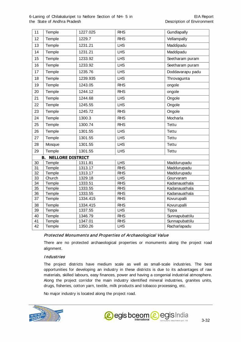
6-Laning of Chilakaluripet to Nellore Section of NH- 5 in
the State of Andhra Pradesh
EIA Report
Description of Environment
3-32
11 Temple 1227.025 RHS Gundlapally
12 Temple 1229.7 RHS Vellampally
13 Temple 1231.21 LHS Maddipadu
14 Temple 1231.21 LHS Maddipadu
15 Temple 1233.92 LHS Seetharam puram
16 Temple 1233.92 LHS Seetharam puram
17 Temple 1235.76 LHS Doddavarapu padu
18 Temple 1239.935 LHS Throvagunta
19 Temple 1243.05 RHS ongole
20 Temple 1244.12 RHS ongole
21 Temple 1244.68 LHS Ongole
22 Temple 1245.55 LHS Ongole
23 Temple 1245.72 RHS Ongole
24 Temple 1300.3 RHS Mocharla
25 Temple 1300.74 RHS Tettu
26 Temple 1301.55 LHS Tettu
27 Temple 1301.55 LHS Tettu
28 Mosque 1301.55 LHS Tettu
29 Temple 1301.55 LHS Tettu
B. NELLORE DISTRICT 30 Temple 1311.81 LHS Maddurupadu
31 Temple 1313.17 RHS Maddurupadu
32 Temple 1313.17 RHS Maddurupadu
33 Church 1329.18 LHS Gourvaram
34 Temple 1333.51 RHS Kadanauathala
35 Temple 1333.55 RHS Kadanauathala
36 Temple 1333.55 RHS Kadanauathala
37 Temple 1334.415 RHS Kovurupalli
38 Temple 1334.415 RHS Kovurupalli
39 Temple 1337.55 LHS Tippa
40 Temple 1346.79 RHS Sunnapubattilu
41 Temple 1347.01 RHS Sunnapubattilu
42 Temple 1350.26 LHS Racharlapadu
Protected Monuments and Properties of Archaeological Value
There are no protected archaeological properties or monuments along the project road
alignment.
Industries
The project districts have medium scale as well as small-scale industries. The best
opportunities for developing an industry in these districts is due to its advantages of raw
materials, skilled labours, easy finances, power and having a congenial industrial atmosphere.
Along the project corridor the main industry identified mineral industries, granites units,
drugs, fisheries, cotton yarn, textile, milk products and tobacco processing, etc.
No major industry is located along the project road.

6-Laning of Chilakaluripet to Nellore Section of NH- 5 in the
State of Andhra Pradesh
EIA Report
Description of Environment (Annexure 3.1)
ANNEXURE-3.1

6-Laning of Chilakaluripet to Nellore Section of NH- 5 in the
State of Andhra Pradesh
EIA Report
Description of Environment (Annexure 3.1)

6-Laning of Chilakaluripet to Nellore Section of NH- 5 in the
State of Andhra Pradesh
EIA Report
Description of Environment (Annexure 3.1)

6-Laning of Chilakaluripet to Nellore Section of NH- 5 in the
State of Andhra Pradesh
EIA Report
Description of Environment (Annexure 3.1)

6-Laning of Chilakaluripet to Nellore Section of NH- 5 in the State of Andhra Pradesh
EIA Report Description of Environment
(Annexure 3.2)
ANNEXURE-3.2
WIND ROSES OF NELLORE AND ONGOLE (PERIOD 1975-1990) (Source IMD, Hyderabad)

6-Laning of Chilakaluripet to Nellore Section of NH- 5 in the State of Andhra Pradesh
EIA Report Description of Environment
(Annexure 3.2)

6-Laning of Chilakaluripet to Nellore Section of NH- 5 in the State of Andhra Pradesh
EIA Report Description of Environment
(Annexure 3.2)
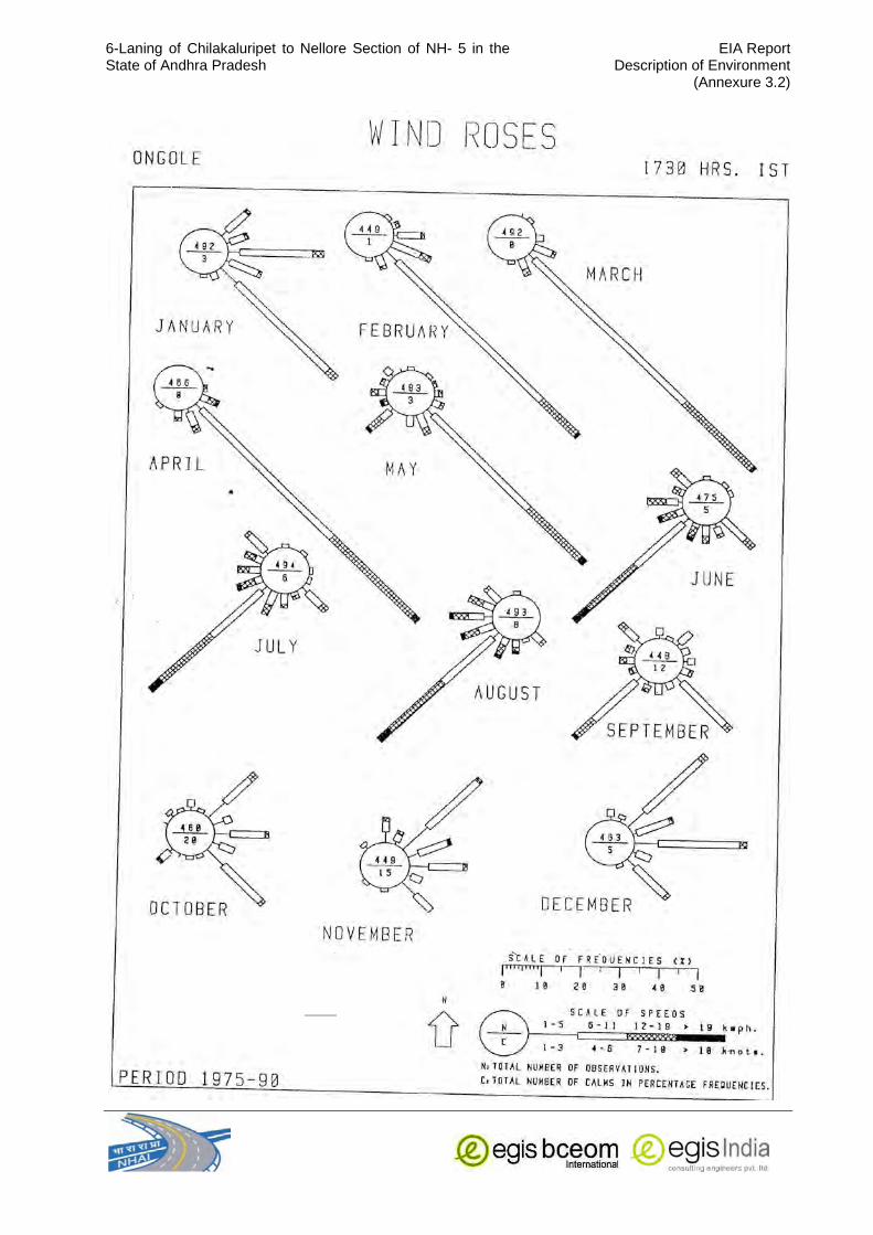
6-Laning of Chilakaluripet to Nellore Section of NH- 5 in the State of Andhra Pradesh
EIA Report Description of Environment
(Annexure 3.2)

6-Laning of Chilakaluripet to Nellore Section of NH- 5 in the
State of Andhra Pradesh
EIA Report
Description of Environment (Annexure 3.3)
ANNEXURE 3.3
AVERAGE DAILY WEATHER CONDITION AT ONGOLE
Sl No
Date Temperature (°C) Average daily wind Speed
(m/sec)
Humidity (%)
Rainfall (mm)
Maximum Minimum Maximum Minimum
1 06.01.2011 31 21 1.1 94 36 0
2 07.01.2011 28 21 1.275 89 44 0
3 08.01.2011 29 22 0.1375 88 42 0
4 09.01.2011 30 21 1.1125 94 48 0
5 10.01.2011 29 22 1.2791 92 41 0
6 11.01.2012 30 20 1.15 85 30 0
7 12.01.2013 28 20 1.1291 84 30 0
8 13.01.2014 30 19 1.1833 80 45 0
9 14.01.2015 29 20 1.2541 90 43 0
10 15.01.2016 29 21 1.0333 93 38 0
11 16.01.2017 29 21 1.1125 90 42 0
12 17.01.2018 31 21 0.9875 92 26 0
13 18.01.2019 30 21 1.0625 90 48 0
14 19.01.2020 30 21 1.025 90 40 0
15 20.01.2021 29 21 1.0333 86 43 0
16 21.01.2022 29 21 1.2416 92 46 0
17 22.01.2023 83 21 1.0625 93 56 0
18 23.01.2024 28 21 0.6666 94 38 0
19 24.01.2025 30 21 1.2833 92 39 0
20 25.01.2026 23 21 1.325 91 36 0
21 26.01.2027 29 21 1.1416 92 39 0
22 27.01.2028 31 22 1.1458 92 40 0
23 28.01.2029 28 22 1.2708 90 40 0
24 29.01.2030 28 21 1.0875 92 41 0
25 30.01.2031 31 22 1.1958 92 38 0
26 31.01.2032 29 22 1.1833 92 38 0
27 01.02.2011. 31 21 1.10833 94 36 0
28 02.02.2011. 31 21 1.2291 92 49 0
29 03.02.2011. 28 22 0.83 93 45 0
30 04.02.2011. 30 22 1.3125 93 42 0
31 05..02.2011. 31 22 1.3333 94 39 0
Month Average
31.03 21.12 1.1 91 41 0

6-Laning of Chilakaluripet to Nellore Section of NH- 5 in the
State of Andhra Pradesh
EIA Report
Description of Environment (Annexure 3.4)
ANNEXURE 3.4
Chainage wise Land use pattern for project road
Chainage (Km) Land use Remarks
From To LHS RHS
1182+802 1184+200 Agriculture Agriculture
1184+300 Pond
1184+200 1185+800 Agriculture Agriculture
1185+800 1186+000 Tank Martur
1185+800 1186+300 Granite Industry Martur
1186+000 1192+000 Village Village Martur
1192+000 1195+400 Agriculture Agriculture
1195+400 Pond Konanki
1195+500 1196+500 Village Village Konanki
1196+500 1198+700 Agriculture Agriculture
1198+700 1198+900 Open Area Agg
1198+900 1199+400 Open Area Open Area
1199+400 1200+000 Toll Plaza Toll Plaza Bolla palli
1200+000 1202+000 Agriculture Agriculture
1202+000 1202+400 Builtup Builtup
1202+400 1203+100 Agriculture Barren
1203+100 1204+100 Agriculture Agriculture
1204+100 1205+100 Village Village Muppavaram
1205+500 1207+300 Agriculture Agriculture
1207+300 1207+700 Village Village Jagarlamudivaripale
m
1207+700 1208+600 Agriculture Agriculture
1208+600 1209+800 Village Village Renangivaram
1209+800 1214+300 Agriculture Agriculture
1214+300 1214+700 Village Village Korisa padu
1214+700 1218+200 Agriculture Agriculture
1218+200 1218+800 Agriculture Hill
1218+800 1218+900 Agriculture Agriculture
1218+900 1219+100 Shops Shops
1219+100 1222+900 Agriculture Agriculture
1222+900 1224+000 Village Village Timmanapalem
1223+116 Tank
1224+000 1224+700 Open Area Open Area
1224+700 1225+400 Agriculture Agriculture
1225+400 1226+500 Open Area Open Area
1226+500 1227+800 Village Village Gullapalli
1227+800 1230+400 Agriculture Agriculture
1230+400 1232+700 Village Village Maddipadu
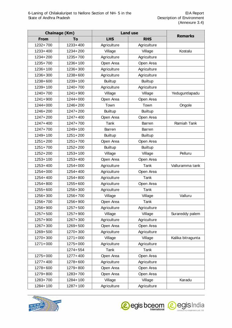
6-Laning of Chilakaluripet to Nellore Section of NH- 5 in the
State of Andhra Pradesh
EIA Report
Description of Environment (Annexure 3.4)
Chainage (Km) Land use Remarks
From To LHS RHS 1232+700 1233+400 Agriculture Agriculture
1233+400 1234+200 Village Village Kostalu
1234+200 1235+700 Agriculture Agriculture
1235+700 1236+100 Open Area Open Area
1236+100 1236+300 Agriculture Agriculture
1236+300 1238+600 Agriculture Agriculture
1238+600 1239+100 Builtup Builtup
1239+100 1240+700 Agriculture Agriculture
1240+700 1241+900 Village Village Yeduguntlapadu
1241+900 1244+000 Open Area Open Area
1244+000 1246+200 Town Town Ongole
1246+200 1247+200 Builtup Builtup
1247+200 1247+400 Open Area Open Area
1247+400 1247+700 Tank Barren Ramiah Tank
1247+700 1249+100 Barren Barren
1249+100 1251+200 Builtup Builtup
1251+200 1251+700 Open Area Open Area
1251+700 1252+200 Builtup Builtup
1252+200 1253+100 Village Village Pelluru
1253+100 1253+400 Open Area Open Area
1253+400 1254+000 Agriculture Tank Valluramma tank
1254+000 1254+400 Agriculture Open Area
1254+400 1254+800 Agriculture Tank
1254+800 1255+600 Agriculture Open Area
1255+600 1256+300 Agriculture Tank
1256+300 1256+700 Village Village Valluru
1256+700 1256+900 Open Area Tank
1256+900 1257+500 Agriculture Agriculture
1257+500 1257+900 Village Village Surareddy palem
1257+900 1267+300 Agriculture Agriculture
1267+300 1269+500 Open Area Open Area
1269+500 1270+300 Agriculture Agriculture
1270+300 1271+000 Village Village Kalika bitragunta
1271+000 1275+000 Agriculture Agriculture
1274+554 Tank Tank
1275+000 1277+400 Open Area Open Area
1277+400 1278+600 Agriculture Agriculture
1278+600 1279+800 Open Area Open Area
1279+800 1283+700 Open Area Open Area
1283+700 1284+100 Village Village Karadu
1284+100 1287+100 Agriculture Agriculture

6-Laning of Chilakaluripet to Nellore Section of NH- 5 in the
State of Andhra Pradesh
EIA Report
Description of Environment (Annexure 3.4)
Chainage (Km) Land use Remarks
From To LHS RHS 1287+100 1288+900 Open Area Open Area
1288+900 1291+600 Agriculture Agriculture
1291+600 1291+900 Builtup Builtup
1291+900 1292+700 Reserve Forest Tank
1292+700 1293+400 Reserve Forest Reserve Forest
1293+400 1294+600 Reserve Forest Agg
1294+600 1294+900 Village Village Chagallu
1294+900 1295+200 Reserve Forest Builtup
1295+200 1297+200 Agriculture Agriculture
1297+200 1298+800 Reserve Forest Reserve Forest
1298+800 1300+200 Agriculture Agriculture
1300+200 1300+800 Village Village Mocharla
1300+800 1301+400 Open Area Open Area
1301+400 1302+000 Builtup Tank Tettu
1302+000 1302+400 Village Village Tettu
1302+400 1304+200 Reserve Forest Reserve Forest
1304+200 1304+700 Village Village Ravuru
1304+700 1305+100 Open Area Open Area
1305+100 1305+600 Agriculture Agriculture
1305+600 1306+000 Builtup Open Area
1306+000 1306+800 Tank Tank Ekurupadu
1306+800 1308+100 Reserve Forest Reserve Forest
1308+100 1308+500 Agriculture Agriculture
1308+500 1309+500 Agriculture Open Area
1309+500 1310+000 Open Area Open Area
1310+000 1311+200 Agriculture Agriculture
1311+200 1311+800 Open Area Open Area
1311+800 1313+500 Village Village Madduru padu
1313+500 1319+300 Agriculture Agriculture
1319+300 1319+900 Tank Tank Jutur
1319+900 1324+300 Barren Barren
1324+300 1324+400 Tank Tank Musnur
1324+400 1328+500 Agriculture Agriculture
1328+500 1329+300 Village Village Gowrawaram
1329+300 1330+500 Agriculture Tank Gowrawaram
1330+500 1333+000 Agriculture Agriculture
1333+000 1333+700 Village Village Kadumetla
1333+700 1333+900 Agriculture Agriculture
1333+900 1335+000 Agriculture Tank Kadunutala
1335+000 1335+300 Agriculture Agriculture
1335+300 1335+700 Agriculture Tank Kavurpalli
1335+700 1336+300 Agriculture Agriculture

6-Laning of Chilakaluripet to Nellore Section of NH- 5 in the
State of Andhra Pradesh
EIA Report
Description of Environment (Annexure 3.4)
Chainage (Km) Land use Remarks
From To LHS RHS 1336+300 1337+100 Village Village Bogolu
1337+100 1337+900 Agriculture Agriculture
1337+900 1340+000 Open Area Open Area
1340+000 1340+700 Village Village Vulavapadu
1340+700 1342+800 Agriculture Agriculture
1342+800 1343+100 Agriculture Tank Lions nagar
1343+100 1345+800 Open Area Open Area
1345+800 1346+700 Village & Tank Village Sunnapubatti
1346+700 1349+400 Open Area Open Area
1349+400 1349+750 Open Area Tank
1349+750 1350+100 Open Area Agriculture
1350+100 1350+500 Village Village Racharlapadu
1350+500 1351+100 Agriculture Agriculture
1351+100 1353+000 Open Area Open Area
1353+000 1354+300 Village Village
1354+300 1355+100 Agriculture Agriculture
1355+100 1355+400 Village Village Boddavaripalem
1355+400 1356+800 Agriculture Agriculture
1356+800 1357+500 Village Village Naidupalem
1357+500 1358+200 Agriculture Agriculture
1358+200 1360+100 Barren Barren
1360+100 1366+500 Agriculture Agriculture

6-Laning of Chilakaluripet to Nellore Section of NH- 5 in the State of Andhra Pradesh
EIA Report Description of Environment
(Annexure 3.5)
ANNEXURE 3.5

6-Laning of Chilakaluripet to Nellore Section of NH- 5 in the State of Andhra Pradesh
EIA Report Description of Environment
(Annexure 3.5)

6-Laning of Chilakaluripet to Nellore Section of NH- 5 in the State of Andhra Pradesh
EIA Report Description of Environment
(Annexure 3.5)

6-Laning of Chilakaluripet to Nellore Section of NH- 5 in the State of Andhra Pradesh
EIA Report Description of Environment
(Annexure 3.5)

6-Laning of Chilakaluripet to Nellore Section of NH- 5 in the State of Andhra Pradesh
EIA Report Description of Environment
(Annexure 3.6)
Catchment of Major rivers along the project stretch ANNEXURE-3.6
GOOGLE Earth extract of Major Rivers Gundalakamma (KM 1229) and Mudigandi (KM 1240)
GOOGLE Earth extract of Major Rivers Musi (KM 1262), Palleru (KM 1269) and other Streams
GOOGLE Earth extract of Major Rivers Maneru (KM 1282.5) and Chillavagu Stream (KM 1286)

6-Laning of Chilakaluripet to Nellore Section of NH- 5 in the State of Andhra Pradesh
EIA Report Description of Environment
(Annexure 3.7)
ANNEXURE 3.7
List of Bore Well/Well, Hand pump and Water Tanks within Corridor of Impact Sl No Type of Features Location
Chianage (Km)
LHS/ RHS from Centre line
Village/Town
A. Guntur District Total Affected F eatures in Guntur District
Bore well 0 Open well 0
Hand pump 0 Water tank 0
B. Prakasam District 1 Bore well 1185+980 RHS Rajupalem
2 Bore well 1186+485 RHS Martur
3 Bore well 1187+300 RHS Martur
4 Bore well 1187+720 RHS Martur
5 Bore well 1187+780 RHS Martur
6 Bore well 1187+880 RHS Martur
7 Water tank 1188+500 RHS Martur
8 Bore well 1188+590 RHS Martur
9 Bore well 1188+635 RHS Martur
10 Bore well 1188+640 RHS Martur
11 Bore well 1188+725 RHS Martur
12 Bore well 1188+800 RHS Martur
13 Bore well 1191+800 LHS Jonnatali
14 Bore well 1194+425 RHS Konanki
15 Bore well 1194+435 RHS Konanki
16 Bore well 1194+460 RHS Konanki
17 Open well 1194+460 RHS Konanki
18 Bore well 1194+560 RHS Konanki
19 Water tank 1194+560 RHS Konanki
20 Bore well 1195+825 RHS Konanki
21 Open well 1195+825 RHS Konanki
22 Bore well 1199+380 RHS Bollapalli
23 Open well 1200+630 RHS Kondamanjulur
24 Bore well 1200+660 RHS Kondamanjulur
25 Burwell 1202+100 RHS Narne varipalem
26 Bore well 1202+150 RHS Narne varipalem
27 Water tank 1204+680 RHS Muppavaram
28 Bore well 1204+700 LHS Muppavaram
29 Bore well 1204+790 RHS Muppavaram
30 Open well 1207+660 RHS Jagarlamudi vari palem
31 Bore well 1208+620 RHS Ranangivaram

6-Laning of Chilakaluripet to Nellore Section of NH- 5 in the State of Andhra Pradesh
EIA Report Description of Environment
(Annexure 3.7)
Sl No Type of Features Location Chianage
(Km) LHS/ RHS from
Centre line Village/Town
32 Bore well 1210+500 RHS Alavalapadu
33 Open well 1211+450 RHS Venkatapuram
34 Bore well 1215+010 LHS Korisapadu
35 Water tank 1219+500 LHS Medara metla
36 Bore well 1226+630 RHS Gundlapally
37 Bore well 1226+980 RHS Gundlapally
38 Water tank 1226+980 RHS Gundlapally
39 Bore well 1229+530 RHS Vellampally
40 Bore well 1229+700 RHS Vellampally
41 Open well 1233+920 LHS Seetharam puram
42 Bore well 1245+245 RHS Ongole
43 Bore well 1245+425 RHS Ongole
44 Bore well 1245+440 RHS Ongole
45 Bore well 1245+500 RHS Ongole
46 Bore well 1245+790 RHS Ongole
47 Bore well 1246+100 RHS ongole
48 Bore well 1246+650 RHS ongole
49 Bore well 1252+700 RHS Pelluru
50 Hand Pump 1252+800 RHS Pelluru
51 Open well 1259+300 RHS Surareddy palem
52 Bore well 1259+300 RHS Surareddy palem
53 Water tank 1263+010 RHS Tangutur
54 Bore well 1270+230 RHS Tangutur
55 Bore well 1270+250 RHS K. Bitragunta
56 Bore well 1270+750 LHS K. Bitragunta
57 Bore well 1277+900 RHS Singarayakonda
58 Bore well 1283+830 RHS Karedu
59 Open well 1285+550 RHS Ulvapadu
60 Bore well 1291+600 RHS Narne varipalem
61 Open well 1294+830 RHS Chagallu
62 Open well 1294+890 RHS Chagallu
63 Open well 1300+542 RHS Mocharla
64 Bore well 1300+770 LHS Tettu
65 Hand Pump 1301+800 RHS Tettu
66 Open well 1302+400 RHS Tettu
67 Bore well 1302+400 RHS Tettu
Total Affected Features in Prakasam District Bore well 47
Open well 12 Hand pump 2 Water tank 6
C. Nellore District

6-Laning of Chilakaluripet to Nellore Section of NH- 5 in the State of Andhra Pradesh
EIA Report Description of Environment
(Annexure 3.7)
Sl No Type of Features Location Chianage
(Km) LHS/ RHS from
Centre line Village/Town
1 Openwell 1311+935 RHS Maddurupadu
2 Openwell 1312+140 RHS Maddurupadu
3 Openwell 1312+700 RHS Maddurupadu
4 Openwell 1313+170 RHS Maddurupadu
5 Openwell 1313+170 RHS Maddurupadu
6 Openwell 1313+190 RHS Maddurupadu
7 Openwell 1328+700 RHS Gourvaram
8 Openwell 1328+950 LHS Gourvaram
9 Openwell 1328+980 RHS Gourvaram
10 Openwell 1329+100 LHS Gourvaram
11 Openwell 1329+110 RHS Gourvaram
12 Openwell 1330+525 RHS Gourvaram
13 Openwell 1333+545 RHS Kadanauathala
14 Openwell 1334+435 RHS Kovurupalli
15 Openwell 1334+465 RHS Kovurupalli
16 Openwell 1334+495 RHS Kovurupalli
17 Openwell 1346+800 RHS Sunnapubattilu
18 Openwell 1353+090 RHS Regadichelika
19 Openwell 1353+120 RHS Regadichelika
20 Openwell 1354+035 RHS Chandra sekara palem
Total Affected Features in Nellore District Bore well 0 Open well 20
Hand pump 0 Water tank 0
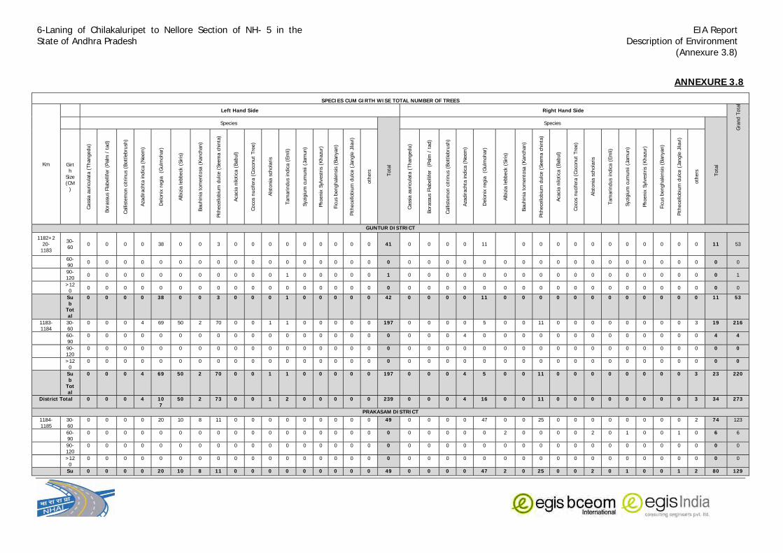
6-Laning of Chilakaluripet to Nellore Section of NH- 5 in the State of Andhra Pradesh
EIA Report Description of Environment
(Annexure 3.8)
ANNEXURE 3.8
SPECIES CUM GIRTH WISE TOTAL NUMBER OF TREES
Km
Left Hand Side Right Hand Side
Gra
nd T
ota
l
Species
Tota
l
Species
Tota
l Girth
Size (CM
)
Cass
ia a
uricu
lata
(Thangedu)
Bora
ssus
Fla
belli
fer
(Palm
/ t
ad)
Calli
stem
on c
itrinus
(Bott
lebru
sh)
Aza
dirach
ta indic
a (
Neem
)
Delo
nix
regia
(G
ulm
ohar)
Alb
izia
lebbeck
(Siris
)
Bauhin
ia t
om
ento
sa (
Kanch
an)
Pithece
llobiu
m d
ulc
e (
Seem
a c
hin
ta)
Aca
cia n
ilotica
(Babul)
Coco
s nuci
fera
(Coco
nut
Tre
e)
Als
tonia
sch
ola
ris
Tam
arindus
indic
a (
Em
li)
Syzi
giu
m c
um
unii
(Jam
un)
Phoenix
Sylv
est
ris
(Khazu
r)
Fic
us
benghale
nsi
s (B
anyan)
Pithece
llobiu
m d
ulc
e (
Jangle
Jila
vi)
oth
ers
GUNTUR DISTRICT
1182+220-
1183
30-60
0 0 0 0 38 0 0 3 0 0 0 0 0 0 0 0 0 41 0 0 0 0 11
0 0 0 0 0 0 0 0 0 0 0 11 53
60-90
0 0 0 0 0 0 0 0 0 0 0 0 0 0 0 0 0 0 0 0 0 0 0 0 0 0 0 0 0 0 0 0 0 0 0 0 0
90-120
0 0 0 0 0 0 0 0 0 0 0 1 0 0 0 0 0 1 0 0 0 0 0 0 0 0 0 0 0 0 0 0 0 0 0 0 1
>12
0 0 0 0 0 0 0 0 0 0 0 0 0 0 0 0 0 0 0 0 0 0 0 0 0 0 0 0 0 0 0 0 0 0 0 0 0 0
Sub
Total
0 0 0 0 38 0 0 3 0 0 0 1 0 0 0 0 0 42 0 0 0 0 11 0 0 0 0 0 0 0 0 0 0 0 0 11 53
1183-1184
30-60
0 0 0 4 69 50 2 70 0 0 1 1 0 0 0 0 0 197 0 0 0 0 5 0 0 11 0 0 0 0 0 0 0 0 3 19 216
60-90
0 0 0 0 0 0 0 0 0 0 0 0 0 0 0 0 0 0 0 0 0 4 0 0 0 0 0 0 0 0 0 0 0 0 0 4 4
90-120
0 0 0 0 0 0 0 0 0 0 0 0 0 0 0 0 0 0 0 0 0 0 0 0 0 0 0 0 0 0 0 0 0 0 0 0 0
>120
0 0 0 0 0 0 0 0 0 0 0 0 0 0 0 0 0 0 0 0 0 0 0 0 0 0 0 0 0 0 0 0 0 0 0 0 0
Sub
Total
0 0 0 4 69 50 2 70 0 0 1 1 0 0 0 0 0 197 0 0 0 4 5 0 0 11 0 0 0 0 0 0 0 0 3 23 220
District Total 0 0 0 4 107
50 2 73 0 0 1 2 0 0 0 0 0 239 0 0 0 4 16 0 0 11 0 0 0 0 0 0 0 0 3 34 273
PRAKASAM DISTRICT1184-1185
30-60
0 0 0 0 20 10 8 11 0 0 0 0 0 0 0 0 0 49 0 0 0 0 47 0 0 25 0 0 0 0 0 0 0 0 2 74 123
60-90
0 0 0 0 0 0 0 0 0 0 0 0 0 0 0 0 0 0 0 0 0 0 0 2 0 0 0 0 2 0 1 0 0 1 0 6 6
90-120
0 0 0 0 0 0 0 0 0 0 0 0 0 0 0 0 0 0 0 0 0 0 0 0 0 0 0 0 0 0 0 0 0 0 0 0 0
>120
0 0 0 0 0 0 0 0 0 0 0 0 0 0 0 0 0 0 0 0 0 0 0 0 0 0 0 0 0 0 0 0 0 0 0 0 0
Su 0 0 0 0 20 10 8 11 0 0 0 0 0 0 0 0 0 49 0 0 0 0 47 2 0 25 0 0 2 0 1 0 0 1 2 80 129

6-Laning of Chilakaluripet to Nellore Section of NH- 5 in the State of Andhra Pradesh
EIA Report Description of Environment
(Annexure 3.8)
b Total
1185-1186
30-60
0 0 0 0 35 51 33 0 12 0 5 1 0 0 0 0 137 0 0 0 0 25 20 0 0 3 0 0 0 0 0 0 0 1 49 186
60-90
0 0 0 0 0 0 0 0 0 0 0 0 0 0 0 0 0 0 0 0 0 0 0 0 0 0 0 0 0 0 0 0 0 0 0 0 0
90-120
0 0 0 0 0 0 0 0 0 0 0 0 0 0 0 0 0 0 0 3 4 2 0 0 0 0 0 0 0 1 0 0 0 0 0 10 10
>120
0 0 0 0 0 0 0 0 0 0 0 0 0 0 0 0 0 0 0 0 0 0 0 0 0 0 0 0 0 0 0 0 0 0 0 0 0
Sub
Total
0 0 0 0 35 51 33 0 12 0 0 5 1 0 0 0 0 137 0 3 4 2 25 20 0 0 3 0 0 1 0 0 0 0 1 59 196
1186-1187
30-60
0 0 0 0 5 4 0 0 0 0 0 0 0 0 0 0 0 10 0 0 0 0 5 1 2 1 0 0 0 0 0 0 0 0 9 19
60-90
0 0 0 0 0 0 0 0 0 0 0 0 0 0 0 0 0 3 0 0 0 0 0 0 3 0 0 0 0 0 0 0 0 0 6 6
90-120
0 0 0 0 0 0 0 1 0 0 0 0 0 0 0 0 0 0 0 0 1 0 0 0 0 0 0 0 0 0 0 0 0 0 1 1
>120
0 0 0 0 0 0 0 0 0 0 0 0 0 0 0 0 0 0 0 0 0 0 0 0 0 0 0 0 0 0 1 0 0 1 1
Sub
Total
0 0 0 0 5 4 0 1 0 0 0 0 0 0 0 0 0 10 3 0 0 1 5 1 2 4 0 0 0 0 0 0 1 0 0 17 27
1187-1188
30-60
0 0 0 0 0 0 0 0 0 0 0 0 0 0 0 0 0 0 0 0 0 0 0 0 1 2 0 0 3 2 1 0 0 1 0 10 10
60-90
0 1 1 1 1 1 0 0 0 0 0 1 0 0 0 0 0 6 0 0 0 3 0 0 0 0 0 0 0 0 0 0 0 1 0 4 10
90-120
0 1 0 7 0 0 0 0 0 1 0 0 0 0 0 0 0 9 0 0 0 0 0 0 0 0 0 0 0 0 0 0 0 0 0 0 9
>120
0 0 0 0 0 0 0 0 0 0 0 0 0 0 1 0 0 1 0 0 0 0 0 0 0 0 0 0 0 0 0 0 1 0 0 1 2
Sub
Total
0 2 1 8 1 1 0 0 0 1 0 1 0 0 1 0 0 16 0 0 0 3 0 0 1 2 0 0 3 2 1 0 1 2 0 15 31
1188-1189
30-60
0 0 0 0 0 0 0 0 0 0 0 0 0 0 0 0 0 0 0 0 0 0 1 0 0 0 0 0 0 0 0 0 0 0 0 1 1
60-90
0 0 0 0 0 0 0 0 0 0 0 0 0 0 0 0 0 0 0 0 0 4 0 0 0 0 0 0 5 4 2 0 8 0 23 23
90-120
0 0 0 0 0 0 0 0 0 0 0 0 0 0 0 0 0 0 16 0 1 0 0 0 0 0 1 0 0 0 0 0 0 0 18 18
>120
0 0 0 0 0 0 0 0 0 0 0 0 0 0 0 0 0 0 0 0 3 0 0 0 0 0 0 0 0 0 0 1 0 0 4 4
Sub
Total
0 0 0 0 0 0 0 0 0 0 0 0 0 0 0 0 0 0 0 16 0 4 5 0 0 0 0 1 0 5 4 2 1 8 0 46 46
1189-1190
30-60
0 0 0 0 2 0 0 0 0 0 0 0 0 0 0 0 0 2 2 0 0 0 2 3 1 0 0 0 0 1 0 0 0 1 0 10 12
60-90
0 0 0 0 0 0 0 0 0 0 0 0 0 0 0 0 0 0 0 0 0 1 0 0 1 0 0 0 0 0 0 0 0 0 0 2 2
90-120
0 0 0 2 0 3 0 0 0 0 0 0 0 0 0 0 0 5 0 0 0 0 0 0 0 0 0 0 0 0 0 0 1 0 0 1 6
>120
0 0 0 0 0 0 0 0 0 0 0 0 0 0 0 0 0 0 0 0 0 0 0 0 0 0 0 0 0 0 0 0 0 0 0 0 0
Sub
Total
0 0 0 2 2 3 0 0 0 0 0 0 0 0 0 0 0 7 2 0 0 1 2 3 2 0 0 0 0 1 0 0 1 1 0 13 20

6-Laning of Chilakaluripet to Nellore Section of NH- 5 in the State of Andhra Pradesh
EIA Report Description of Environment
(Annexure 3.8)
1190-1191
30-60
0 0 0 0 0 0 0 0 0 0 0 0 0 0 0 0 0 2 0 2 2 30 35 4 3 2 0 2 5 2 0 0 5 0 94 94
60-90
0 0 0 0 0 0 0 0 0 0 0 0 0 0 0 0 0 0 0 0 3 0 0 0 0 0 0 0 0 0 0 0 0 0 3 3
90-120
0 0 0 0 0 0 0 0 0 0 0 0 0 0 0 0 0 0 0 0 5 0 0 0 0 0 0 0 1 1 1 0 1 0 9 9
>120
0 0 0 0 0 0 0 0 0 0 0 0 0 0 0 0 0 0 0 0 0 0 0 0 0 0 0 0 0 0 0 1 0 0 1 1
Sub
Total
0 0 0 0 0 0 0 0 0 0 0 0 0 0 0 0 0 0 2 0 2 10 30 35 4 3 2 0 2 6 3 1 1 6 0 107 107
1191-1192
30-60
0 0 0 0 3 2 0 0 0 0 0 0 0 0 0 0 0 5 0 0 0 0 20 20 20 0 11 0 14 15 6 0 0 14 0 120 125
60-90
0 0 0 1 0 0 0 0 0 0 0 0 0 0 0 0 0 1 0 0 0 5 0 0 0 0 0 0 0 1 0 0 0 1 0 7 8
90-120
0 0 0 1 0 0 0 0 0 0 0 0 0 0 0 0 0 1 0 0 0 2 0 0 0 0 0 1 2 1 1 1 0 8 9
>120
0 0 0 0 0 0 0 0 0 0 0 0 0 0 0 0 0 0 0 0 0 1 0 0 0 0 0 0 0 0 0 0 1 0 0 2 2
Sub
Total
0 0 0 2 3 2 0 0 0 0 0 0 0 0 0 0 0 7 0 0 0 8 20 20 20 0 11 1 14 18 6 1 2 16 0 137 144
1192-1193
30-60
5 0 3 0 25 19 8 0 0 0 5 6 0 0 0 0 0 71 0 0 10 0 11 13 4 4 5 0 17 17 2 0 2 4 89 160
60-90
1 0 0 6 0 0 0 0 0 0 0 0 0 0 0 0 0 7 0 0 0 7 0 0 0 0 0 0 0 0 0 0 0 0 0 7 14
90-120
2 1 0 6 0 0 0 0 0 0 0 0 0 0 0 0 0 9 0 0 0 0 0 0 0 0 0 0 0 5 4 0 0 4 0 13 22
>120
0 0 0 0 0 0 0 0 0 0 0 0 0 0 0 0 0 0 0 0 0 0 0 0 0 0 0 0 0 0 0 0 0 0 0 0 0
Sub
Total
8 1 3 12 25 19 8 0 0 0 5 6 0 0 0 0 0 87 0 0 10 7 11 13 4 4 5 0 17 22 6 0 0 6 4 109 196
1193-1194
30-60
31 15 1 0 8 2 8 1 0 0 0 0 0 0 0 0 5 71 65 0 0 0 3 4 3 0 2 0 0 0 0 0 0 2 1 80 151
60-90
4 5 0 0 0 0 0 1 0 0 0 0 0 0 0 5 0 15 0 0 0 0 0 0 0 0 0 0 0 1 0 0 0 0 0 1 16
90-120
0 3 0 0 0 0 0 0 0 0 0 2 0 0 1 2 0 8 0 0 0 0 0 0 0 0 0 0 0 0 0 0 1 0 0 1 9
>120
0 0 0 0 0 0 0 0 0 0 0 0 0 0 0 0 0 0 0 0 0 0 0 0 0 0 0 0 0 0 0 0 0 0 0 0 0
Sub
Total
35 23 1 0 8 2 8 2 0 0 0 2 0 0 1 7 5 94 65 0 0 0 3 4 3 0 2 0 0 1 0 0 1 2 1 82 176
1194-1195
30-60
16 4 11 0 3 17 1 1 0 8 9 4 0 0 5 0 79 13 3 5 0 5 2 12 0 5 0 0 0 0 0 0 0 0 45 124
60-90
1 0 0 0 0 0 0 0 0 0 0 0 0 0 0 0 0 1 1 0 0 0 0 1 1 0 0 0 0 0 0 0 0 2 0 5 6
90-120
0 4 0 0 0 0 0 0 0 0 0 0 0 0 1 0 0 5 0 3 0 2 0 2 3 7 0 1 5 2 4 0 1 2 0 32 37
>120
0 0 0 0 0 0 0 0 0 0 0 0 0 0 0 0 0 0 0 0 0 0 0 0 0 0 0 0 0 0 0 0 0 0 0 0 0
Sub
Total
17 8 11 0 3 0 17 1 1 0 8 9 4 0 1 5 0 85 14 6 5 2 5 5 16 7 5 1 5 2 4 0 1 4 0 82 167
1195-1196
30-60
3 0 3 0 24 0 0 0 0 0 0 0 1 0 0 1 0 32 0 0 3 0 3 0 1 1 3 0 0 0 0 0 0 0 0 11 43
60-90
0 0 0 0 0 0 0 0 0 0 0 0 0 0 0 0 0 0 0 5 0 3 0 0 0 0 0 5 0 0 0 0 0 0 0 13 13

6-Laning of Chilakaluripet to Nellore Section of NH- 5 in the State of Andhra Pradesh
EIA Report Description of Environment
(Annexure 3.8)
90-120
0 0 0 0 0 0 0 0 0 0 0 0 0 0 0 0 0 0 0 2 0 2 2 0 1 2 0 2 0 0 0 0 0 0 0 11 11
>120
0 0 0 0 0 0 0 0 0 0 0 0 0 0 0 0 0 0 0 0 0 0 0 0 0 0 0 0 0 0 0 0 0 0 0 0 0
Sub
Total
3 0 3 0 24 0 0 0 0 0 0 0 1 0 0 1 0 32 0 7 3 5 5 0 2 3 3 7 0 0 0 0 0 0 0 35 67
1196-1197
30-60
0 0 0 0 0 0 0 7 5 0 4 5 2 0 0 5 2 30 0 3 0 0 0 0 0 30 11 0 0 1 2 0 0 2 2 51 81
60-90
0 0 0 0 0 0 0 0 0 0 0 0 0 0 0 0 0 0 0 0 0 0 0 0 0 0 0 0 0 1 0 0 0 3 0 4 4
90-120
0 0 0 0 0 0 0 0 0 0 0 0 0 0 0 0 0 0 0 0 0 0 0 0 0 0 0 0 0 0 0 0 1 0 0 1 1
>120
0 0 0 0 0 0 0 0 0 0 0 0 0 0 0 0 0 0 0 0 0 0 0 0 0 0 0 0 0 0 0 0 0 0 0 0 0
Sub
Total
0 0 0 0 0 0 0 7 5 0 4 5 2 0 0 5 2 30 0 3 0 0 0 0 0 30 11 0 0 2 2 0 1 5 2 56 86
1197-1198
30-60
0 0 0 0 0 0 0 0 0 0 0 0 0 0 0 0 0 0 0 0 0 0 0 0 0 3 0 0 0 0 0 0 0 0 0 3 3
60-90
0 0 0 0 0 0 0 0 0 0 0 0 0 0 0 0 0 0 0 0 0 0 0 0 0 0 0 0 0 0 0 0 0 0 0 0 0
90-120
0 0 0 0 0 0 0 0 0 0 0 0 0 0 0 0 0 0 0 0 0 0 0 0 0 0 0 0 0 0 0 0 0 0 0 0 0
>120
0 0 0 0 0 0 0 0 0 0 0 0 0 0 0 0 0 0 0 0 0 0 0 0 0 0 0 0 0 0 0 0 0 0 0 0 0
Sub
Total
0 0 0 0 0 0 0 0 0 0 0 0 0 0 0 0 0 0 0 0 0 0 0 0 0 3 0 0 0 0 0 0 0 0 0 3 3
1198-1199
30-60
0 0 0 0 0 0 0 0 0 0 0 0 0 0 0 0 0 0 0 0 0 0 0 0 0 0 1 0 0 0 0 0 0 0 0 1 1
60-90
0 8 1 0 0 0 0 0 0 0 0 0 0 0 0 0 0 9 0 0 0 0 0 0 0 0 0 0 0 0 0 0 0 0 0 0 9
90-120
0 1 0 0 0 0 0 0 0 0 0 0 0 0 0 0 0 1 0 4 0 0 0 0 0 0 0 0 0 0 0 0 0 0 0 4 5
>120
0 0 0 0 0 0 0 0 0 0 0 0 0 0 0 0 0 0 0 0 0 0 0 0 0 0 0 0 0 0 0 0 0 0 0 0
Sub
Total
0 9 1 0 0 0 0 0 0 0 0 0 0 0 0 0 0 10 0 4 0 0 0 0 0 0 1 0 0 0 0 0 0 0 0 5 15
1199-1200
30-60
0 0 1 0 0 0 0 0 1 0 0 0 0 0 0 0 0 2 0 0 4 1 0 0 2 0 1 0 0 0 0 0 0 0 0 8 10
60-90
0 18 1 0 0 0 0 0 0 0 0 0 0 0 0 0 0 19 0 0 3 0 0 0 0 0 0 0 0 0 0 0 0 0 0 3 22
90-120
0 10 0 0 0 0 0 0 0 0 0 0 0 0 0 0 0 10 0 0 0 0 0 0 0 0 0 0 0 4 0 0 0 0 0 4 14
>120
0 0 0 0 0 0 0 0 0 0 0 0 0 0 0 0 0 0 0 0 0 0 0 0 0 0 0 0 0 0 0 0 0 0 0 0
Sub
Total
0 28 2 0 0 0 0 0 1 0 0 0 0 0 0 0 0 31 0 0 7 1 0 0 2 0 1 0 0 4 0 0 0 0 0 15 46
1200-1201
30-60
3 0 0 0 3 0 0 0 0 0 0 1 0 0 0 0 0 7 1 0 0 0 0 1 1 1 3 0 4 1 0 0 0 2 14 21
60-90
0 2 0 0 0 0 0 0 0 0 0 0 0 0 0 0 0 2 1 0 0 0 0 0 0 0 0 4 0 0 0 0 0 0 0 5 7
90-120
0 3 0 0 0 0 0 0 0 0 0 0 0 0 0 0 0 3 0 0 0 2 0 0 0 0 0 0 0 1 0 0 1 0 0 4 7
>120
0 0 0 0 0 0 0 0 0 0 0 0 0 0 0 0 0 0 0 0 0 0 0 0 0 0 0 0 0 0 0 0 0 0 0 0 0

6-Laning of Chilakaluripet to Nellore Section of NH- 5 in the State of Andhra Pradesh
EIA Report Description of Environment
(Annexure 3.8)
Sub
Total
3 5 0 0 3 0 0 0 0 0 0 1 0 0 0 0 0 12 2 0 0 2 0 1 1 1 3 4 0 5 1 0 1 0 2 23 35
1201-1202
30-60
0 0 1 0 7 4 6 0 0 0 0 0 0 0 0 0 0 18 4 0 0 0 6 2 3 0 0 0 0 0 0 0 0 0 0 15 33
60-90
0 1 0 2 0 0 0 0 0 0 0 0 0 0 0 0 0 3 0 7 0 0 0 0 0 2 0 0 0 0 0 0 0 0 0 9 12
90-120
0 7 0 0 0 0 0 0 0 0 0 0 0 0 0 0 0 7 0 0 0 0 0 0 0 0 0 0 0 0 0 0 0 0 0 0 7
>120
0 0 0 0 0 0 0 0 0 0 0 0 0 0 0 0 0 0 0 0 0 0 0 0 0 0 0 0 0 0 0 0 0 0 0 0 0
Sub
Total
0 8 1 2 7 4 6 0 0 0 0 0 0 0 0 0 0 28 4 7 0 0 6 2 3 2 0 0 0 0 0 0 0 0 0 24 52
1202-1203
30-60
0 0 0 0 0 0 4 0 0 0 0 0 0 0 0 0 0 4 0 0 0 0 8 0 6 2 0 0 0 0 0 0 0 0 4 20 24
60-90
0 0 0 0 0 0 0 0 0 0 0 0 0 0 0 0 0 0 0 0 0 1 0 0 0 1 0 2 0 0 0 0 0 0 0 4 4
90-120
0 0 0 0 0 0 0 0 0 0 0 0 0 0 0 0 0 0 0 7 0 3 0 0 0 2 0 0 0 0 0 0 0 0 0 12 12
>120
0 0 0 0 0 0 0 0 0 0 0 0 0 0 0 0 0 0 0 0 0 0 0 0 0 0 0 0 0 0 0 0 0 0 0 0 0
Sub
Total
0 0 0 0 0 0 4 0 0 0 0 0 0 0 0 0 0 4 0 7 0 4 8 0 6 5 0 2 0 0 0 0 0 0 4 36 40
1203-1204
30-60
0 0 6 0 0 0 38 3 0 0 0 0 0 0 0 0 3 50 0 0 0 0 2 1 2 0 2 0 0 0 0 0 0 0 0 7 57
60-90
0 0 0 0 0 0 0 0 0 0 0 0 0 0 0 0 0 0 0 0 0 0 0 0 0 0 0 0 0 0 0 0 0 0 0 0 0
90-120
0 2 0 0 0 0 0 1 0 0 0 0 0 0 0 0 0 3 0 2 0 0 0 0 1 0 0 0 0 0 0 0 0 0 0 3 6
>120
0 0 0 0 0 0 0 0 0 0 0 0 0 0 0 0 0 0 0 0 0 0 0 0 0 0 0 0 0 0 0 0 0 0 0 0 0
Sub
Total
0 2 6 0 0 0 38 4 0 0 0 0 0 0 0 0 3 53 0 2 0 0 2 1 3 0 2 0 0 0 0 0 0 0 0 10 63
1204-1205
30-60
0 0 0 1 0 0 0 0 0 0 0 0 0 0 0 0 1 0 0 0 0 0 0 6 0 0 0 0 0 0 0 0 0 0 6 7
60-90
0 0 0 0 0 0 0 0 0 6 0 0 0 0 0 0 0 6 0 0 0 0 0 0 1 0 0 10 0 0 0 0 0 0 0 11 17
90-120
0 0 0 1 0 0 0 0 0 0 0 2 1 0 0 0 0 4 0 3 0 3 0 0 5 0 0 1 0 6 4 0 1 4 0 27 31
>120
0 0 0 0 0 0 0 0 0 0 0 0 0 0 0 0 0 0 0 0 0 0 0 0 0 0 0 0 0 0 0 0 0 0 0 0 0
Sub
Total
0 0 0 2 0 0 0 0 0 6 0 2 1 0 0 0 0 11 0 3 0 3 0 0 12 0 0 11 0 6 4 0 1 4 0 44 55
1205-1206
30-60
0 0 5 0 110 50 0 0 3 1 0 0 0 0 0 0 1 170 0 0 0 0 40 37 4 1 0 0 0 0 0 0 0 0 0 82 252
60-90
0 6 0 3 0 0 0 0 0 0 0 3 0 0 0 1 0 13 1 0 5 10 0 0 2 0 1 2 0 1 0 0 0 0 0 22 35
90-120
0 84 0 0 0 0 0 0 0 0 0 0 0 0 0 0 0 84 0 44 10 0 0 0 0 0 0 0 0 1 2 0 1 4 0 62 146
>120
0 0 0 0 0 0 0 0 0 0 0 0 0 0 0 0 0 0 0 0 0 0 0 0 0 0 0 0 0 0 0 0 0 0 0 0 0
Sub
Total
0 90 5 3 110
50 0 0 3 1 0 3 0 0 0 1 1 267 1 44 15 10 40 37 6 1 1 2 0 2 2 0 1 4 0 166 433

6-Laning of Chilakaluripet to Nellore Section of NH- 5 in the State of Andhra Pradesh
EIA Report Description of Environment
(Annexure 3.8)
1206-1207
30-60
0 0 0 0 36 0 0 15 3 0 9 15 0 0 0 3 5 86 0 0 0 0 99 88 0 21 14 0 1 0 0 0 2 1 226 312
60-90
0 6 0 0 0 0 0 0 0 0 0 0 0 0 0 0 0 6 0 0 0 0 0 0 0 0 0 0 0 0 0 0 0 0 0 0 6
90-120
0 0 0 0 0 0 0 0 0 0 0 0 0 0 0 0 0 0 0 0 0 0 0 0 0 0 0 0 0 0 0 0 0 0 0 0 0
>120
0 0 0 0 0 0 0 0 0 0 0 0 0 0 0 0 0 0 0 0 0 0 0 0 0 0 0 0 0 0 0 0 0 0 0 0 0
Sub
Total
0 6 0 0 36 0 0 15 3 0 9 15 0 0 0 3 5 92 0 0 0 0 99 88 0 21 14 0 0 1 0 0 0 2 1 226 318
1207-1208
30-60
2 0 0 0 2 0 0 10 2 0 8 14 6 0 0 4 5 53 0 0 2 0 0 0 5 3 1 11 9 1 0 0 0 4 36 89
60-90
0 0 0 0 0 0 0 0 0 0 0 0 0 0 0 0 0 0 0 0 0 0 0 0 0 0 0 4 0 0 0 0 0 0 0 4 4
90-120
0 7 0 0 0 0 0 0 0 0 0 0 0 0 0 0 0 7 0 15 0 3 0 0 0 3 0 0 0 0 0 0 0 0 0 21 28
>120
0 0 0 0 0 0 0 0 0 0 0 0 0 0 0 0 0 0 0 0 0 0 0 0 0 0 0 0 0 0 0 0 0 0 0 0 0
Sub
Total
2 7 0 0 2 0 0 10 2 0 8 14 6 0 0 4 5 60 0 15 2 3 0 0 0 8 3 5 11 9 1 0 0 0 4 61 121
1208-1209
30-60
0 0 7 0 2 2 0 0 2 4 0 0 0 0 0 0 3 20 2 0 5 0 2 2 0 3 2 0 0 11 0 0 0 10 6 43 63
60-90
0 0 0 3 0 0 0 2 0 4 0 0 0 0 0 0 0 9 0 0 0 1 0 0 0 6 0 0 10 6 3 0 0 5 0 31 40
90-120
0 9 0 0 0 0 0 6 0 0 0 0 0 0 0 0 0 15 0 0 0 6 0 0 0 0 0 0 0 1 1 1 2 0 11 26
>120
0 0 0 0 0 0 0 0 0 0 0 0 0 0 0 0 0 0 0 0 0 0 0 0 0 0 0 0 0 0 0 0 0 0 0 0 0
Sub
Total
0 9 7 3 2 2 0 8 2 8 0 0 0 0 0 0 3 44 2 0 5 7 2 2 0 9 2 0 10 18 4 0 1 17 6 85 129
1209-1210
30-60
0 0 2 5 3 0 0 0 0 0 0 0 0 0 0 0 0 10 0 0 0 0 0 0 0 0 0 0 5 6 0 0 5 7 23 33
60-90
0 0 0 2 0 0 0 4 0 0 1 0 0 0 0 2 2 11 0 0 0 5 0 0 0 0 0 0 0 4 5 4 0 9 0 27 38
90-120
0 19 0 11 0 0 0 0 0 0 0 0 0 0 0 0 0 30 0 0 0 0 0 0 0 8 0 0 0 0 2 0 1 4 0 15 45
>120
0 0 0 0 0 0 0 0 0 0 0 0 0 0 0 0 0 0 0 0 0 0 0 0 0 0 0 0 0 0 0 0 0 0 0 0 0
Sub
Total
0 19 2 18 3 0 0 4 0 0 1 0 0 0 0 2 2 51 0 0 0 5 0 0 0 8 0 0 0 9 13 4 1 18 7 65 116
1210-1211
30-60
17 0 0 2 2 0 0 5 0 0 0 0 0 0 0 0 1 27 0 0 3 0 0 0 0 0 0 0 0 2 0 0 0 0 0 5 32
60-90
1 0 0 0 0 0 0 0 0 0 0 0 0 0 0 0 0 1 0 0 0 0 0 0 0 0 0 0 0 0 0 0 0 0 0 0 1
90-120
0 0 0 0 0 0 0 0 0 0 0 0 0 0 0 0 0 0 0 3 0 1 0 0 0 0 0 0 0 3 0 0 0 3 0 10 10
>120
0 0 0 0 0 0 0 0 0 0 0 0 0 0 0 0 0 0 0 0 0 0 0 0 0 0 0 0 0 0 0 0 0 0 0 0 0
Sub
Total
18 0 0 2 2 0 0 5 0 0 0 0 0 0 0 0 1 28 0 3 3 1 0 0 0 0 0 0 0 5 0 0 0 3 0 15 43
1211-1212
30-60
3 0 4 0 68 45 0 6 0 0 0 0 0 0 0 0 0 126 0 0 0 0 47 65 0 0 0 0 0 0 0 0 0 0 0 112 238
60-90
0 0 0 0 0 0 0 2 0 0 0 0 0 0 0 0 0 2 0 0 9 1 0 0 0 0 0 0 0 0 0 0 0 0 0 10 12
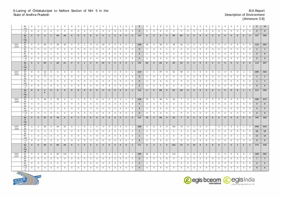
6-Laning of Chilakaluripet to Nellore Section of NH- 5 in the State of Andhra Pradesh
EIA Report Description of Environment
(Annexure 3.8)
90-120
0 0 0 1 0 0 0 0 0 0 0 3 1 0 0 0 0 5 0 0 0 2 3 0 0 0 0 0 0 0 0 0 0 0 0 5 10
>120
0 0 0 0 0 0 0 0 0 0 0 0 0 0 0 0 0 0 0 0 0 0 0 0 0 0 0 0 0 0 0 0 0 0 0 0 0
Sub
Total
3 0 4 1 68 45 0 8 0 0 0 3 1 0 0 0 0 133 0 0 9 3 50 65 0 0 0 0 0 0 0 0 0 0 0 127 260
1212-1213
30-60
0 0 80 0 26 20 0 0 1 0 0 10 0 0 0 0 1 138 26 0 26 5 40 16 0 0 0 0 0 0 0 0 0 0 0 113 251
60-90
0 0 0 0 0 0 0 0 0 0 0 0 0 0 0 0 0 0 0 0 0 1 0 0 0 0 0 0 0 0 0 0 0 0 0 1 1
90-120
0 3 0 1 0 1 0 0 0 0 0 0 0 0 0 0 0 5 0 0 0 0 0 0 0 0 0 0 0 0 0 0 0 0 0 0 5
>120
0 0 0 0 0 0 0 0 0 0 0 0 0 0 0 0 0 0 0 0 0 0 0 0 0 0 0 0 0 0 0 0 0 0 0 0 0
Sub
Total
0 3 80 1 26 21 0 0 1 0 0 10 0 0 0 0 1 143 26 0 26 6 40 16 0 0 0 0 0 0 0 0 0 0 0 114 257
1213-1214
30-60
9 0 100
0 0 0 0 0 0 0 0 5 0 0 0 0 1 115 0 0 97 0 61 49 0 0 0 0 0 0 0 0 0 1 1 209 324
60-90
0 0 0 0 0 0 0 0 0 0 0 0 0 0 0 0 0 0 0 0 1 0 0 0 0 0 0 0 0 0 0 0 0 0 0 1 1
90-120
0 0 0 0 0 0 0 0 0 0 0 0 0 0 0 0 0 0 0 0 0 0 0 0 0 0 0 0 0 1 0 0 0 0 0 1 1
>120
0 0 0 0 0 0 0 0 0 0 0 0 0 0 0 0 0 0 0 0 0 0 0 0 0 0 0 0 0 0 0 0 0 0 0 0 0
Sub
Total
9 0 ##
0 0 0 0 0 0 0 0 5 0 0 0 0 1 115 0 0 98 0 61 49 0 0 0 0 0 1 0 0 0 1 1 211 326
1214-1215
30-60
0 0 35 0 76 0 0 1 0 0 0 5 0 0 0 1 0 118 79 0 48 0 22 7 0 0 0 0 0 0 0 0 0 0 0 156 274
60-90
3 0 2 0 0 0 0 0 0 0 0 0 0 0 0 0 0 5 0 0 0 0 0 0 0 0 0 0 0 0 0 0 0 0 0 0 5
90-120
0 0 0 0 0 0 0 0 0 0 0 0 0 0 0 0 0 0 0 4 0 0 0 0 0 0 0 0 0 0 0 0 0 0 0 4 4
>120
0 0 0 0 0 0 0 0 0 0 0 0 0 0 0 0 0 0 0 0 0 0 0 0 0 0 0 0 0 0 0 0 0 0 0 0 0
Sub
Total
3 0 37 0 76 0 0 1 0 0 0 5 0 0 0 1 0 123 79 4 48 0 22 7 0 0 0 0 0 0 0 0 0 0 0 160 283
1215-1216
30-60
3 0 30 0 84 43 0 1 0 1 2 4 0 0 0 0 1 169 0 0 0 0 161 73 0 2 0 0 5 1 0 0 1 2 245 414
60-90
0 0 0 0 0 0 0 0 0 1 0 0 0 0 0 0 0 1 0 0 0 3 0 0 0 12 0 0 0 3 0 0 0 0 0 18 19
90-120
1 0 0 0 0 0 0 0 0 0 0 0 0 0 0 0 0 1 0 4 1 2 0 0 0 1 0 0 0 1 0 0 1 1 0 11 12
>120
0 0 0 0 0 0 0 0 0 0 0 0 0 0 0 0 0 0 0 0 0 0 0 0 0 0 0 0 0 0 0 0 0 0 0 0 0
Sub
Total
4 0 30 0 84 43 0 1 0 2 2 4 0 0 0 0 1 171 0 4 1 5 161 73 0 15 0 0 0 9 1 0 1 2 2 274 445
1216-1217
30-60
0 0 20 0 60 110 0 0 1 0 0 0 0 0 0 0 1 192 48 0 2 0 112 0 0 0 0 5 0 0 0 0 2 169 361
60-90
0 0 0 0 0 0 0 0 0 0 0 0 0 0 0 0 0 0 5 0 2 0 0 0 0 0 0 0 0 0 0 0 0 0 0 7 7
90-120
0 0 0 0 0 0 0 0 0 0 0 0 0 0 0 0 0 0 2 0 0 0 0 0 0 0 0 0 0 0 0 0 0 0 0 2 2
>120
0 0 0 0 0 0 0 0 0 0 0 0 0 0 0 0 0 0 0 0 0 0 0 0 0 0 0 0 0 0 0 0 0 0 0 0 0

6-Laning of Chilakaluripet to Nellore Section of NH- 5 in the State of Andhra Pradesh
EIA Report Description of Environment
(Annexure 3.8)
Sub
Total
0 0 20 0 60 110
0 0 1 0 0 0 0 0 0 0 1 192 55 0 4 0 112 0 0 0 0 0 0 5 0 0 0 0 2 178 370
1217-1218
30-60
0 0 2 0 64 23 0 0 6 0 10 15 0 0 6 0 126 50 0 0 0 39 0 0 3 0 4 3 0 0 0 0 1 100 226
60-90
0 0 0 0 0 0 0 0 0 0 0 0 0 0 0 0 0 0 6 0 0 0 0 0 0 0 0 0 0 2 0 0 0 0 0 8 8
90-120
0 0 0 0 0 0 0 0 0 0 0 0 0 0 0 0 0 0 0 0 0 0 0 0 0 0 0 0 0 0 0 0 0 0 0 0 0
>120
0 0 0 0 0 0 0 0 0 0 0 0 0 0 0 0 0 0 0 0 0 0 0 0 0 0 0 0 0 0 0 0 0 0 0 0 0
Sub
Total
0 0 2 0 64 23 0 0 6 0 0 10 15 0 0 6 0 126 56 0 0 0 39 0 0 0 3 0 4 5 0 0 0 0 1 108 234
1218-1219
30-60
0 0 0 0 4 3 0 0 0 0 0 0 0 0 0 0 0 7 0 0 0 0 0 0 0 1 0 0 0 0 0 0 0 0 1 8
60-90
0 0 0 0 0 0 0 0 0 0 0 0 0 0 0 0 0 0 0 0 0 0 0 0 0 0 0 0 0 0 0 0 0 0 0 0 0
90-120
0 0 0 0 0 0 0 0 0 0 0 0 0 0 0 0 0 0 0 0 0 0 0 0 0 0 0 0 0 0 0 0 0 0 0 0 0
>120
0 0 0 0 0 0 0 0 0 0 0 0 0 0 0 0 0 0 0 0 0 0 0 0 0 0 0 0 0 0 0 0 0 0 0 0 0
Sub
Total
0 0 0 0 4 3 0 0 0 0 0 0 0 0 0 0 0 7 0 0 0 0 0 0 0 0 1 0 0 0 0 0 0 0 0 1 8
1219-1220
30-60
0 0 0 0 0 0 0 60 0 0 0 0 0 0 0 0 0 60 0 0 0 0 30 0 0 0 0 0 0 0 0 0 0 0 0 30 90
60-90
0 0 0 0 0 0 0 0 0 0 0 0 0 0 0 0 0 0 0 0 0 0 1 0 0 0 0 0 0 0 0 0 0 0 0 1 1
90-120
0 0 0 0 0 0 0 0 0 0 0 0 0 0 0 0 0 0 0 0 0 0 0 0 0 0 0 0 0 0 0 0 0 0 0 0 0
>120
0 0 0 0 0 0 0 0 0 0 0 0 0 0 0 0 0 0 0 0 0 0 0 0 0 0 0 0 0 0 0 0 0 0 0 0 0
Sub
Total
0 0 0 0 0 0 0 60 0 0 0 0 0 0 0 0 0 60 0 0 0 0 31 0 0 0 0 0 0 0 0 0 0 0 0 31 91
1220-1221
30-60
0 0 0 0 0 0 0 0 0 0 0 2 0 0 0 0 0 2 0 0 0 0 160 24 0 0 0 0 0 0 0 0 0 0 0 184 186
60-90
0 0 0 0 0 0 0 0 0 0 0 0 0 0 0 0 0 0 0 0 0 0 21 0 0 0 0 0 0 0 0 0 0 0 0 21 21
90-120
0 0 0 0 0 0 0 0 0 0 0 0 0 0 0 0 0 0 0 0 0 0 0 0 0 0 0 0 0 0 0 0 0 0 0 0 0
>120
0 0 0 0 0 0 0 0 0 0 0 0 0 0 0 0 0 0 0 0 0 0 0 0 0 0 0 0 0 0 0 0 0 0 0 0 0
Sub
Total
0 0 0 0 0 0 0 0 0 0 0 2 0 0 0 0 0 2 0 0 0 0 181 24 0 0 0 0 0 0 0 0 0 0 0 205 207
1221-1222
30-60
0 0 4 0 37 0 0 0 0 0 10 5 4 0 2 0 0 62 0 0 1 1 173 51 0 0 0 0 0 0 0 0 0 0 0 226 288
60-90
0 0 0 0 0 0 0 0 0 0 0 0 0 0 0 0 0 0 0 0 1 1 17 0 0 0 0 0 0 2 0 0 0 1 0 22 22
90-120
0 0 0 2 0 0 0 0 0 0 0 4 0 0 0 0 0 6 0 0 0 0 0 0 0 0 0 0 0 0 0 0 0 0 0 0 6
>120
0 0 0 0 0 0 0 0 0 0 0 0 0 0 0 0 0 0 0 0 0 0 0 0 0 0 0 0 0 0 0 0 0 0 0 0 0
Sub
Total
0 0 4 2 37 0 0 0 0 0 10 9 4 0 2 0 0 68 0 0 2 2 190 51 0 0 0 0 0 2 0 0 0 1 0 248 316
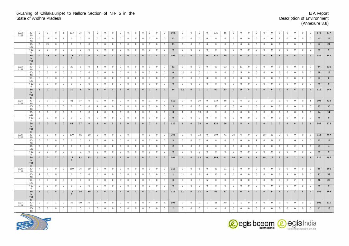
6-Laning of Chilakaluripet to Nellore Section of NH- 5 in the State of Andhra Pradesh
EIA Report Description of Environment
(Annexure 3.8)
1222-1223
30-60
0 0 0 1 133 27 0 0 0 0 0 0 0 0 0 0 0 161 0 0 0 0 121 55 0 0 0 0 0 0 0 0 0 0 0 176 337
60-90
0 12 0 1 0 0 0 0 0 0 0 0 0 0 0 0 0 13 0 0 0 0 0 0 0 0 0 0 4 6 3 0 0 0 0 13 26
90-120
0 21 0 0 0 0 0 0 0 0 0 0 0 0 0 0 0 21 0 0 0 0 0 0 0 0 0 0 0 0 0 0 0 0 0 0 21
>120
0 0 0 0 0 0 0 0 0 0 0 0 0 0 0 0 0 0 0 0 0 0 0 0 0 0 0 0 0 0 0 0 0 0 0 0 0
Sub
Total
0 33 0 2 133
27 0 0 0 0 0 0 0 0 0 0 0 195 0 0 0 0 121 55 0 0 0 0 4 6 3 0 0 0 0 189 384
1223-1224
30-60
0 0 2 0 20 9 0 1 0 0 0 0 0 0 0 0 0 32 0 0 0 0 60 23 0 11 0 0 0 0 0 0 0 0 0 94 126
60-90
0 0 0 0 0 0 0 0 0 0 0 0 0 0 0 0 0 0 12 0 0 1 0 0 0 5 0 0 0 0 0 0 0 0 0 18 18
90-120
2 0 0 0 0 0 0 0 0 0 0 0 0 0 0 0 0 2 0 0 0 0 0 0 0 0 0 0 0 0 0 0 0 0 0 0 2
>120
0 0 0 0 0 0 0 0 0 0 0 0 0 0 0 0 0 0 0 0 0 0 0 0 0 0 0 0 0 0 0 0 0 0 0 0 0
Sub
Total
2 0 2 0 20 9 0 1 0 0 0 0 0 0 0 0 0 34 12 0 0 1 60 23 0 16 0 0 0 0 0 0 0 0 0 112 146
1224-1225
30-60
0 0 1 0 81 37 0 0 0 0 0 0 0 0 0 0 0 119 0 0 20 0 110 66 0 5 2 0 2 0 0 0 0 1 206 325
60-90
0 0 2 0 0 0 0 1 0 0 0 0 0 0 0 0 0 3 0 0 5 0 20 0 0 0 2 0 0 0 0 0 0 0 0 27 30
90-120
0 0 2 0 0 0 0 1 0 0 0 0 0 0 0 0 0 3 1 0 13 0 0 0 0 0 0 0 0 0 0 0 0 0 0 14 17
>120
0 0 0 0 0 0 0 0 0 0 0 0 0 0 0 0 0 0 0 0 0 0 0 0 0 0 0 0 0 0 0 0 0 0 0 0 0
Sub
Total
0 0 5 0 81 37 0 2 0 0 0 0 0 0 0 0 0 125 1 0 38 0 130 66 0 5 4 0 0 2 0 0 0 0 1 247 372
1225-1226
30-60
0 0 5 0 130 91 30 0 0 0 0 0 0 0 0 0 256 0 0 13 0 109 41 16 6 0 0 10 12 2 0 0 0 2 211 467
60-90
0 0 0 0 0 0 3 0 0 0 0 0 0 0 0 0 0 3 0 0 0 0 0 0 0 0 0 1 0 5 3 0 4 0 13 16
90-120
0 0 2 0 0 0 0 0 0 0 0 0 0 0 0 0 0 2 0 0 0 0 0 0 0 0 0 0 0 0 0 0 2 0 0 2 4
>120
0 0 0 0 0 0 0 0 0 0 0 0 0 0 0 0 0 0 0 0 0 0 0 0 0 0 0 0 0 0 0 0 0 0 0 0 0
Sub
Total
0 0 7 0 130
91 33 0 0 0 0 0 0 0 0 0 0 261 0 0 13 0 109 41 16 6 0 1 10 17 5 0 2 4 2 226 487
1226-1227
30-60
4 0 0 0 159 34 19 0 0 0 0 0 0 0 0 0 0 216 0 0 6 0 53 31 0 0 0 0 0 0 0 0 0 0 0 90 306
60-90
1 0 0 0 0 0 0 0 0 0 0 0 0 0 0 0 1 11 0 5 4 10 0 0 0 0 0 0 0 0 1 0 0 0 31 32
90-120
0 0 0 0 0 0 0 0 0 0 0 0 0 0 0 0 0 0 0 0 0 5 0 0 0 0 0 0 0 9 4 0 2 5 0 25 25
>120
0 0 0 0 0 0 0 0 0 0 0 0 0 0 0 0 0 0 0 0 0 0 0 0 0 0 0 0 0 0 0 0 0 0 0 0 0
Sub
Total
5 0 0 0 159
34 19 0 0 0 0 0 0 0 0 0 0 217 11 0 11 9 63 31 0 0 0 0 0 9 4 1 2 5 0 146 363
1227-1228
30-60
0 0 1 0 49 39 0 0 0 0 0 6 0 0 4 0 6 105 0 0 0 1 58 40 0 1 0 5 0 0 0 0 0 0 0 105 210
60-90
0 0 0 0 1 0 1 0 0 0 0 0 0 0 0 0 0 2 0 0 0 1 4 6 0 0 0 0 0 0 0 0 0 0 0 11 13

6-Laning of Chilakaluripet to Nellore Section of NH- 5 in the State of Andhra Pradesh
EIA Report Description of Environment
(Annexure 3.8)
90-120
0 0 0 0 0 0 0 0 0 0 0 0 0 0 0 0 0 0 0 0 0 0 0 0 0 0 0 0 0 5 0 0 0 3 0 8 8
>120
0 0 0 0 0 0 0 0 0 0 0 0 0 0 0 0 0 0 0 0 0 0 0 0 0 0 0 0 0 0 0 0 0 0 0 0 0
Sub
Total
0 0 1 0 50 39 1 0 0 0 0 6 0 0 4 0 6 107 0 0 0 2 62 46 0 1 0 5 0 5 0 0 0 3 0 124 231
1228-1229
30-60
0 0 0 0 20 9 0 22 0 0 5 3 0 0 1 1 61 19 0 3 0 17 0 0 0 1 0 0 0 0 0 0 0 0 40 101
60-90
0 0 0 0 0 0 0 0 0 0 0 0 0 0 0 0 0 0 17 0 0 0 0 0 0 0 0 0 0 0 0 0 0 0 0 17 17
90-120
0 0 0 0 0 0 0 0 0 0 0 0 0 0 0 0 0 0 1 0 0 2 0 0 0 0 0 0 0 0 0 0 1 0 0 4 4
>120
0 0 0 0 0 0 0 0 0 0 0 0 0 0 0 0 0 0 0 0 0 0 0 0 0 0 0 0 0 0 0 0 0 0 0 0 0
Sub
Total
0 0 0 0 20 9 0 22 0 0 0 5 3 0 0 1 1 61 37 0 3 2 17 0 0 0 1 0 0 0 0 0 1 0 0 61 122
1229-1230
30-60
0 0 0 0 36 22 7 0 0 0 0 2 0 0 0 0 1 68 0 0 0 0 0 0 2 0 4 0 0 0 0 0 0 0 6 74
60-90
0 0 0 0 0 0 0 0 0 0 0 0 0 0 0 0 0 0 0 0 0 0 0 0 0 0 0 6 0 0 0 0 0 0 0 6 6
90-120
0 0 0 0 0 0 0 0 0 0 0 0 0 0 0 0 0 0 0 1 0 4 0 0 0 0 0 0 0 5 0 0 1 0 0 11 11
>120
0 0 0 0 0 0 0 0 0 0 0 0 0 0 0 0 0 0 0 0 0 0 0 0 0 0 0 0 0 0 0 0 0 0 0 0 0
Sub
Total
0 0 0 0 36 22 7 0 0 0 0 2 0 0 0 0 1 68 0 1 0 4 0 0 0 2 0 10 0 5 0 0 1 0 0 23 91
1230-1231
30-60
0 0 0 0 0 0 0 0 0 0 0 0 0 0 0 0 0 0 0 0 3 0 49 15 0 8 0 0 9 18 0 0 0 1 3 106 106
60-90
0 0 1 0 0 0 0 0 0 0 0 1 0 0 0 0 0 2 8 0 0 0 0 0 0 0 0 0 0 0 0 0 0 0 0 8 10
90-120
0 0 0 0 0 0 0 0 0 0 0 2 0 0 0 0 0 2 0 5 0 3 0 0 0 0 0 0 0 0 0 0 1 0 0 9 11
>120
0 0 0 0 0 0 0 0 0 0 0 0 0 0 0 0 0 0 0 0 0 0 0 0 0 0 0 0 0 0 0 0 0 0 0 0 0
Sub
Total
0 0 1 0 0 0 0 0 0 0 0 3 0 0 0 0 0 4 8 5 3 3 49 15 0 8 0 0 9 18 0 0 1 1 3 123 127
1231-1232
30-60
0 0 3 0 0 0 0 0 0 0 0 1 0 0 0 0 1 5 0 0 10 0 126 90 0 0 0 0 5 2 0 0 0 1 1 235 240
60-90
0 0 0 2 0 0 0 0 0 0 0 2 0 0 0 0 0 4 0 0 0 0 5 0 0 0 0 0 4 2 2 0 0 0 0 13 17
90-120
0 0 0 0 0 0 0 0 0 0 0 0 2 0 0 4 0 6 0 0 0 0 0 0 0 0 0 0 0 4 0 0 1 0 0 5 11
>120
0 0 0 0 0 0 0 0 0 0 0 0 0 0 0 0 0 0 0 0 0 0 0 0 0 0 0 0 0 0 0 0 0 0 0 0 0
Sub
Total
0 0 3 2 0 0 0 0 0 0 0 3 2 0 0 4 1 15 0 0 10 0 131 90 0 0 0 0 9 8 2 0 1 1 1 253 268
1232-1233
30-60
0 0 0 0 132 79 2 1 0 1 0 0 0 0 0 0 2 217 0 0 10 0 156 64 0 0 0 0 0 0 0 0 0 0 0 230 447
60-90
0 0 0 3 0 0 1 0 0 0 0 0 0 0 0 0 0 4 0 0 0 1 0 0 0 0 0 0 15 0 0 0 0 4 0 20 24
90-120
0 0 0 0 0 0 3 0 0 0 0 0 0 0 0 0 0 3 1 0 0 0 0 0 0 0 0 0 2 0 0 0 0 0 0 3 6
>120
0 0 0 0 0 0 0 0 0 0 0 0 0 0 0 0 0 0 0 0 0 0 0 0 0 0 0 0 0 0 0 0 2 0 0 2 2

6-Laning of Chilakaluripet to Nellore Section of NH- 5 in the State of Andhra Pradesh
EIA Report Description of Environment
(Annexure 3.8)
Sub
Total
0 0 0 3 132
79 6 1 0 1 0 0 0 0 0 0 2 224 1 0 10 1 156 64 0 0 0 0 17 0 0 0 2 4 0 255 479
1233-1234
30-60
0 0 2 1 161 86 0 0 1 0 0 0 0 0 0 0 1 252 0 0 24 7 137 52 0 1 0 0 6 6 5 2 0 0 2 242 494
60-90
0 0 0 1 0 0 0 0 0 0 0 2 0 0 0 0 0 3 3 0 0 0 0 0 0 0 0 0 0 12 0 0 0 0 0 15 18
90-120
0 0 0 0 0 0 0 0 0 0 0 0 0 0 0 0 0 0 0 0 0 0 0 0 0 0 0 0 0 2 0 0 0 1 0 3 3
>120
0 0 0 0 0 0 0 0 0 0 0 0 0 0 0 0 0 0 0 0 0 0 0 0 0 0 0 0 0 0 0 0 2 0 2 2
Sub
Total
0 0 2 2 161
86 0 0 1 0 0 2 0 0 0 0 1 255 3 0 24 7 137 52 0 1 0 0 6 20 5 2 2 1 2 262 517
1234-1235
30-60
0 0 1 0 134 98 0 0 0 0 0 0 0 0 0 0 0 233 0 0 7 0 82 89 3 2 1 0 0 0 0 0 0 0 2 186 419
60-90
0 0 1 0 0 0 0 0 0 0 0 0 0 0 0 0 0 1 0 0 7 0 5 0 2 0 0 0 0 5 5 0 0 8 4 36 37
90-120
0 0 0 0 0 0 0 0 0 0 0 0 0 0 0 0 0 0 0 2 0 0 0 0 0 0 0 0 0 1 0 0 0 2 0 5 5
>120
0 0 0 0 0 0 0 0 0 0 0 0 0 0 0 0 0 0 0 0 0 0 0 0 0 0 0 0 0 0 0 0 1 0 0 1 1
Sub
Total
0 0 2 0 134
98 0 0 0 0 0 0 0 0 0 0 0 234 0 2 14 0 87 89 5 2 1 0 0 6 5 0 1 10 6 228 462
1235-1236
30-60
0 0 1 1 27 40 0 0 0 0 25 36 27 7 0 6 1 171 0 0 0 0 43 36 0 0 6 0 0 0 0 0 0 0 0 85 256
60-90
0 0 0 1 0 0 0 0 0 9 3 0 0 0 0 0 0 13 0 0 0 0 3 0 0 0 0 2 0 0 0 0 0 0 0 5 18
90-120
0 0 0 0 0 0 0 0 0 0 0 0 0 0 0 1 0 1 0 7 0 1 0 0 0 0 0 0 0 0 0 0 1 0 0 9 10
>120
0 0 0 0 0 0 0 0 0 0 0 0 0 0 0 0 0 0 0 0 0 0 0 0 0 0 0 0 0 0 0 0 0 0 0 0 0
Sub
Total
0 0 1 2 27 40 0 0 0 9 28 36 27 7 0 7 1 185 0 7 0 1 46 36 0 0 6 2 0 0 0 0 1 0 0 99 284
1236-1237
30-60
0 0 0 0 50 75 0 0 1 0 0 4 0 0 0 1 1 132 0 0 37 0 173 67 0 0 0 0 2 4 2 2 0 287 419
60-90
0 0 0 0 0 0 0 0 0 0 0 1 0 0 0 0 0 1 0 0 0 2 10 3 0 0 0 0 0 0 0 0 0 0 0 15 16
90-120
0 0 0 0 0 0 0 0 0 0 0 0 0 0 0 0 0 0 0 0 0 0 0 0 0 0 0 0 0 1 1 0 1 1 0 4 4
>120
0 0 0 0 0 0 0 0 0 0 0 0 0 0 0 0 0 0 0 0 0 0 0 0 0 0 0 0 0 0 0 0 0 0 0 0
Sub
Total
0 0 0 0 50 75 0 0 1 0 0 5 0 0 0 1 1 133 0 0 37 2 183 70 0 0 0 0 2 5 3 0 1 3 0 306 439
1237-1238
30-60
0 0 1 0 130 89 0 0 0 0 0 0 0 0 0 0 1 221 0 0 32 0 212 97 0 0 0 0 5 6 3 0 0 0 3 358 579
60-90
0 0 0 0 0 0 0 0 0 0 0 0 0 0 0 0 0 0 0 0 0 0 0 0 0 0 0 0 0 2 0 0 0 0 0 2 2
90-120
0 0 0 0 0 0 0 0 0 0 0 2 0 0 0 0 0 2 0 0 0 0 0 0 0 0 0 0 0 0 0 0 0 0 0 0 2
>120
0 0 0 0 0 0 0 0 0 0 0 0 0 0 0 0 0 0 0 0 0 0 0 0 0 0 0 0 0 0 0 0 0 0 0 0
Sub
Total
0 0 1 0 130
89 0 0 0 0 0 2 0 0 0 0 1 223 0 0 32 0 212 97 0 0 0 0 5 8 3 0 0 0 3 360 583

6-Laning of Chilakaluripet to Nellore Section of NH- 5 in the State of Andhra Pradesh
EIA Report Description of Environment
(Annexure 3.8)
1238-1239
30-60
0 0 3 0 45 40 0 0 0 0 0 5 1 0 0 0 0 94 0 0 6 0 71 54 0 0 0 5 15 30 12 8 0 15 5 221 315
60-90
0 0 0 1 0 0 0 0 0 0 0 0 0 0 2 0 0 3 0 0 0 0 0 0 0 0 0 0 0 5 0 0 0 1 0 6 9
90-120
0 0 0 0 0 0 0 0 0 0 0 2 0 0 0 0 0 2 0 0 0 0 0 0 0 0 0 0 0 0 0 0 0 0 0 0 2
>120
0 0 0 0 0 0 0 0 0 0 0 0 0 0 0 0 0 0 0 0 0 0 0 0 0 0 0 0 0 0 0 0 2 0 0 2 2
Sub
Total
0 0 3 1 45 40 0 0 0 0 0 7 1 0 2 0 0 99 0 0 6 0 71 54 0 0 0 5 15 35 12 8 2 16 5 229 328
1239-1240
30-60
0 0 0 0 35 12 15 0 0 0 0 0 0 0 0 0 0 62 0 0 1 1 30 35 0 0 1 0 5 2 1 0 0 1 4 81 143
60-90
0 0 0 0 0 0 0 0 0 0 0 0 0 0 0 0 0 0 0 0 0 0 0 0 0 0 0 0 0 0 0 0 0 0 0 0 0
90-120
0 0 0 0 0 0 0 0 0 0 0 0 0 0 0 0 0 0 0 0 0 0 0 0 0 0 0 0 0 4 0 0 0 0 0 4 4
>120
0 0 0 0 0 0 0 0 0 0 0 0 0 0 0 0 0 0 0 0 0 0 0 0 0 0 0 0 0 0 0 0 0 0 0 0 0
Sub
Total
0 0 0 0 35 12 15 0 0 0 0 0 0 0 0 0 0 62 0 0 1 1 30 35 0 0 1 0 5 6 1 0 0 1 4 85 147
1240-1241
30-60
0 0 0 0 2 0 1 0 0 0 0 0 0 0 0 0 1 4 0 0 0 0 0 0 0 0 0 0 0 0 0 0 0 0 0 0 4
60-90
0 0 0 0 0 0 0 0 0 0 0 0 0 0 0 0 0 0 0 0 0 0 0 0 0 0 0 0 0 0 0 0 0 0 0 0 0
90-120
0 0 0 0 0 0 0 0 0 0 0 0 0 0 0 0 0 0 0 0 0 0 0 0 0 0 0 0 0 0 0 0 0 0 0 0 0
>120
0 0 0 0 0 0 0 0 0 0 0 0 0 0 0 0 0 0 0 0 0 0 0 0 0 0 0 0 0 0 0 0 0 0 0 0 0
Sub
Total
0 0 0 0 2 0 1 0 0 0 0 0 0 0 0 0 1 4 0 0 0 0 0 0 0 0 0 0 0 0 0 0 0 0 0 0 4
1241-1242
30-60
0 0 1 0 0 0 0 0 1 0 1 0 0 0 0 0 0 3 0 0 0 0 0 0 0 0 0 0 0 0 0 0 0 0 0 0 3
60-90
0 0 0 2 0 0 0 0 0 0 0 0 0 0 0 0 0 2 0 0 0 0 0 0 0 0 0 0 0 0 0 0 0 0 0 0 2
90-120
0 0 0 6 0 0 0 0 0 0 0 1 0 0 1 0 0 8 0 0 0 0 0 0 0 0 0 0 0 0 0 0 0 0 0 0 8
>120
0 0 0 0 0 0 0 0 0 0 0 0 0 0 0 0 0 0 0 0 0 0 0 0 0 0 0 0 0 0 0 0 0 0 0 0 0
Sub
Total
0 0 1 8 0 0 0 0 1 0 1 1 0 0 1 0 0 13 0 0 0 0 0 0 0 0 0 0 0 0 0 0 0 0 0 0 13
1242-1243
30-60
0 0 0 0 0 0 0 0 0 0 0 0 0 0 0 0 0 0 0 0 0 0 0 0 0 0 0 0 0 0 0 0 0 0 0 0 0
60-90
0 0 0 0 0 0 0 0 0 0 0 0 0 0 0 0 0 0 0 0 0 0 0 0 0 0 0 0 0 0 0 0 0 0 0 0 0
90-120
0 0 0 0 0 0 0 0 0 0 0 0 0 0 0 0 0 0 0 0 0 0 0 0 0 0 0 0 0 0 0 0 0 0 0 0 0
>120
0 0 0 0 0 0 0 0 0 0 0 0 0 0 0 0 0 0 0 0 0 0 0 0 0 0 0 0 0 0 0 0 0 0 0 0 0
Sub
Total
0 0 0 0 0 0 0 0 0 0 0 0 0 0 0 0 0 0 0 0 0 0 0 0 0 0 0 0 0 0 0 0 0 0 0 0 0
1243-1244
30-60
0 0 0 1 0 0 0 0 0 0 0 0 0 0 0 0 0 1 0 0 0 0 0 0 0 0 0 0 0 0 0 0 0 0 0 0 1
60-90
0 0 0 0 0 0 0 0 0 0 0 0 0 0 0 0 0 0 0 0 0 0 0 0 0 0 0 0 0 0 0 0 0 0 0 0 0

6-Laning of Chilakaluripet to Nellore Section of NH- 5 in the State of Andhra Pradesh
EIA Report Description of Environment
(Annexure 3.8)
90-120
0 0 0 0 0 0 0 0 0 0 0 0 0 0 0 0 0 0 0 0 0 0 0 0 0 0 0 0 0 0 0 0 0 0 0 0 0
>120
0 0 0 0 0 0 0 0 0 0 0 0 0 0 0 0 0 0 0 0 0 0 0 0 0 0 0 0 0 0 0 0 0 0 0 0 0
Sub
Total
0 0 0 1 0 0 0 0 0 0 0 0 0 0 0 0 0 1 0 0 0 0 0 0 0 0 0 0 0 0 0 0 0 0 0 0 1
1244-1245
30-60
0 0 0 0 0 0 0 0 0 0 0 0 0 0 0 0 0 0 0 0 0 0 0 0 0 0 0 0 0 0 0 0 0 0 0 0 0
60-90
0 0 0 0 0 0 0 0 0 0 0 0 0 0 0 0 0 0 0 0 0 0 0 0 0 0 0 0 0 0 0 0 0 0 0 0 0
90-120
0 0 0 0 0 0 0 0 0 0 0 0 0 0 0 0 0 0 0 0 0 0 0 0 0 0 0 0 0 0 0 0 0 0 0 0 0
>120
0 0 0 0 0 0 0 0 0 0 0 0 0 0 0 0 0 0 0 0 0 0 0 0 0 0 0 0 0 0 0 0 0 0 0 0 0
Sub
Total
0 0 0 0 0 0 0 0 0 0 0 0 0 0 0 0 0 0 0 0 0 0 0 0 0 0 0 0 0 0 0 0 0 0 0 0 0
1245-1246
30-60
0 0 0 2 1 0 0 0 0 0 0 0 0 0 0 0 1 4 0 0 0 0 0 0 0 0 0 0 0 0 0 0 0 0 0 0 4
60-90
0 0 0 0 0 0 0 0 0 0 0 1 0 0 0 0 0 1 0 0 0 0 0 0 0 0 0 0 0 0 0 0 0 0 0 0 1
90-120
0 0 0 0 0 0 0 0 0 0 0 0 0 0 1 0 0 1 0 0 0 0 0 0 0 0 0 0 0 0 0 0 0 0 0 0 1
>120
0 0 0 0 0 0 0 0 0 0 0 0 0 0 0 0 0 0 0 0 0 0 0 0 0 0 0 0 0 0 0 0 0 0 0 0 0
Sub
Total
0 0 0 2 1 0 0 0 0 0 0 1 0 0 1 0 1 6 0 0 0 0 0 0 0 0 0 0 0 0 0 0 0 0 0 0 6
1246-1247
30-60
0 0 0 0 1 0 0 0 0 0 0 0 0 0 0 0 0 1 0 0 0 0 0 0 0 0 0 0 0 0 0 0 0 0 1
60-90
0 0 0 0 0 0 0 0 0 0 0 0 0 0 0 0 0 0 0 0 0 0 0 0 0 0 0 0 0 0 0 0 0 0 0 0 0
90-120
0 0 0 0 0 0 0 0 0 0 0 0 0 0 0 0 0 0 0 0 0 0 0 0 0 0 0 0 0 1 0 0 0 0 0 1 1
>120
0 0 0 0 0 0 0 0 0 0 0 0 0 0 0 0 0 0 0 0 0 0 0 0 0 0 0 0 0 0 0 0 0 0 0 0 0
Sub
Total
0 0 0 0 1 0 0 0 0 0 0 0 0 0 0 0 0 1 0 0 0 0 0 0 0 0 0 0 0 1 0 0 0 0 0 1 2
1247-1248
30-60
0 0 2 0 56 55 0 0 0 0 0 3 0 0 0 0 1 117 0 0 0 1 8 0 0 0 0 0 0 0 0 0 0 0 0 9 126
60-90
0 0 0 0 0 0 0 0 0 0 0 0 0 0 0 0 0 0 0 0 0 0 0 0 0 0 0 0 0 0 0 0 0 0 0 0 0
90-120
0 0 0 0 0 0 0 0 0 0 0 0 0 0 0 0 0 0 0 0 0 0 0 0 0 0 0 0 0 0 0 0 0 0 0 0 0
>120
0 0 0 0 0 0 0 0 0 0 0 0 0 0 0 0 0 0 0 0 0 0 0 0 0 0 0 0 0 0 0 0 0 0 0 0 0
Sub
Total
0 0 2 0 56 55 0 0 0 0 0 3 0 0 0 0 1 117 0 0 0 1 8 0 0 0 0 0 0 0 0 0 0 0 0 9 126
1248-1249
30-60
42 0 0 0 0 0 42 0 0 0 5 2 2 0 2 1 96 3 0 0 0 11 10 0 0 0 0 0 0 0 0 0 0 0 24 120
60-90
0 0 0 0 0 0 0 0 0 0 0 0 0 0 0 0 0 0 0 0 0 0 0 0 0 0 0 0 0 0 0 0 0 0 0 0 0
90-120
0 0 0 0 0 0 0 0 0 0 0 0 0 0 0 0 0 0 0 0 0 0 0 0 0 0 0 0 0 0 0 0 0 0 0 0 0
>120
0 0 0 0 0 0 0 0 0 0 0 0 0 0 0 0 0 0 0 0 0 0 0 0 0 0 0 0 0 0 0 0 0 0 0 0 0

6-Laning of Chilakaluripet to Nellore Section of NH- 5 in the State of Andhra Pradesh
EIA Report Description of Environment
(Annexure 3.8)
Sub
Total
42 0 0 0 0 0 42 0 0 0 0 5 2 2 0 2 1 96 3 0 0 0 11 10 0 0 0 0 0 0 0 0 0 0 0 24 120
1249-1250
30-60
0 0 1 0 0 0 9 0 0 0 10 11 10 4 0 0 2 47 4 0 1 0 0 0 0 0 0 0 0 0 0 0 0 0 0 5 52
60-90
0 0 0 0 0 0 0 0 0 0 0 0 0 0 0 0 0 0 0 0 0 0 0 0 0 0 0 0 0 0 0 0 0 0 0 0 0
90-120
0 0 0 0 0 0 0 0 0 0 0 1 0 0 0 0 0 1 0 0 0 0 0 0 0 0 0 0 0 0 0 0 0 0 0 0 1
>120
0 0 0 0 0 0 0 0 0 0 0 0 0 0 0 0 0 0 0 0 0 0 0 0 0 0 0 0 0 0 0 0 0 0 0 0 0
Sub
Total
0 0 1 0 0 0 9 0 0 0 10 12 10 4 0 0 2 48 4 0 1 0 0 0 0 0 0 0 0 0 0 0 0 0 0 5 53
1250-1251
30-60
56 0 6 0 0 0 0 0 0 0 0 0 0 0 0 0 2 64 0 0 1 0 0 0 3 0 0 0 1 0 1 0 0 0 2 8 72
60-90
0 0 0 0 0 0 0 0 0 0 0 0 0 0 0 0 0 0 0 0 0 0 0 0 0 0 0 0 0 2 0 0 0 0 0 2 2
90-120
0 0 0 0 0 0 0 0 0 0 0 0 0 0 0 0 0 0 0 0 0 0 0 0 0 0 0 0 0 0 0 0 0 0 0 0 0
>120
0 0 0 0 0 0 0 0 0 0 0 0 0 0 0 0 0 0 0 0 0 0 0 0 0 0 0 0 0 0 0 0 0 0 0 0 0
Sub
Total
56 0 6 0 0 0 0 0 0 0 0 0 0 0 0 0 2 64 0 0 1 0 0 0 3 0 0 0 1 2 1 0 0 0 2 10 74
1251-1252
30-60
11 0 0 0 20 9 0 0 1 0 0 10 8 0 0 0 1 60 12 0 6 0 3 0 75 0 3 0 3 4 0 0 0 1 107 167
60-90
0 0 0 0 0 0 0 0 0 0 0 0 0 0 0 0 0 0 5 0 0 0 0 0 0 0 0 0 0 0 0 0 0 0 0 5 5
90-120
0 0 0 0 0 0 0 0 0 0 0 0 0 0 0 0 0 0 3 0 0 0 0 0 0 0 0 0 0 0 0 0 0 0 3 3
>120
0 0 0 0 0 0 0 0 0 0 0 0 0 0 0 0 0 0 0 0 0 0 0 0 0 0 0 0 0 0 0 0 0 0 0 0 0
Sub
Total
11 0 0 0 20 9 0 0 1 0 0 10 8 0 0 0 1 60 20 0 6 0 3 0 75 0 3 0 3 4 0 0 0 0 1 115 175
1252-1253
30-60
18 2 0 0 4 0 0 0 0 9 14 5 0 0 3 0 0 55 27 0 4 0 20 7 5 0 0 3 1 0 0 0 0 0 0 67 122
60-90
2 0 0 0 0 0 0 0 0 0 0 0 0 0 0 0 0 2 9 0 0 1 0 0 0 0 0 0 0 0 0 0 0 0 0 10 12
90-120
6 0 0 0 0 0 0 0 0 0 0 0 0 0 0 0 0 6 0 0 0 7 0 0 0 0 0 0 0 0 0 0 0 0 0 7 13
>120
0 0 0 0 0 0 0 0 0 0 0 0 0 0 0 0 0 0 0 0 0 0 0 0 0 0 0 0 0 0 0 0 0 0 0 0
Sub
Total
26 2 0 0 4 0 0 0 0 9 14 5 0 0 3 0 0 63 36 0 4 8 20 7 5 0 0 3 1 0 0 0 0 0 0 84 147
1253-1254
30-60
19 0 7 0 0 0 3 0 0 0 10 12 8 0 5 3 67 22 0 0 2 0 0 2 0 21 0 0 0 0 0 0 0 2 49 116
60-90
0 0 0 0 0 0 0 0 0 0 0 0 0 0 0 0 0 0 0 0 2 0 0 0 0 0 0 0 0 0 0 0 0 0 0 2 2
90-120
0 0 0 0 0 0 0 0 0 0 0 0 0 0 0 0 0 0 9 0 9 0 0 0 0 0 0 0 0 0 0 0 0 0 0 18 18
>120
0 0 0 0 0 0 0 0 0 0 0 0 0 0 0 0 0 0 0 0 0 0 0 0 0 0 0 0 0 0 0 0 0 0 0 0
Sub
Total
19 0 7 0 0 0 3 0 0 0 0 10 12 8 0 5 3 67 31 0 11 2 0 0 2 0 21 0 0 0 0 0 0 0 2 69 136

6-Laning of Chilakaluripet to Nellore Section of NH- 5 in the State of Andhra Pradesh
EIA Report Description of Environment
(Annexure 3.8)
1254-1255
30-60
96 0 11 0 10 8 8 0 4 0 0 2 0 0 0 0 2 141 104 0 3 0 25 0 3 0 5 0 2 2 1 0 0 0 145 286
60-90
0 0 0 0 0 0 0 0 0 0 0 0 0 0 0 0 0 0 0 0 0 0 0 0 0 0 0 0 0 0 0 0 0 0 0 0 0
90-120
0 0 0 0 0 0 0 0 0 0 0 0 0 0 0 0 0 0 1 0 0 0 0 0 0 0 0 0 0 0 0 0 0 0 0 1 1
>120
0 0 0 0 0 0 0 0 0 0 0 0 0 0 0 0 0 0 0 0 0 0 0 0 0 0 0 0 0 0 0 0 0 0 0 0 0
Sub
Total
96 0 11 0 10 8 8 0 4 0 0 2 0 0 0 0 2 141 105
0 3 0 25 0 3 0 5 0 2 2 1 0 0 0 0 146 287
1255-1256
30-60
0 0 12 0 101 34 44 0 5 0 6 2 0 0 0 0 2 206 5 1 15 0 0 0 27 0 0 0 4 2 0 0 0 0 1 55 261
60-90
0 0 0 0 0 0 0 0 0 0 0 0 0 0 0 0 0 0 0 0 0 0 0 0 0 0 11 0 0 0 0 0 0 0 0 11 11
90-120
0 0 0 0 0 0 0 0 0 0 0 0 0 0 0 0 0 0 0 0 0 1 0 0 0 0 0 0 0 0 0 0 0 0 0 1 1
>120
0 0 0 0 0 0 0 0 0 0 0 0 0 0 0 0 0 0 0 0 0 0 0 0 0 0 0 0 0 0 0 0 0 0 0 0 0
Sub
Total
0 0 12 0 101
34 44 0 5 0 6 2 0 0 0 0 2 206 5 1 15 1 0 0 27 0 11 0 4 2 0 0 0 0 1 67 273
1256-1257
30-60
69 0 0 1 4 0 0 3 2 4 0 0 0 0 0 0 0 83 0 0 5 0 0 0 0 0 1 0 0 0 0 0 0 0 0 6 89
60-90
0 0 0 0 0 0 0 0 0 0 0 0 0 0 0 0 0 0 0 0 0 0 0 0 0 0 0 0 0 0 0 0 0 0 0 0 0
90-120
4 0 0 0 0 0 0 0 0 0 0 2 0 0 0 0 0 6 3 0 1 3 0 0 0 0 0 0 0 3 0 0 0 0 0 10 16
>120
0 0 0 0 0 0 0 0 0 0 0 0 0 0 0 0 0 0 0 0 0 0 0 0 0 0 0 0 0 0 0 0 0 0 0 0 0
Sub
Total
73 0 0 1 4 0 0 3 2 4 0 2 0 0 0 0 0 89 3 0 6 3 0 0 0 0 1 0 0 3 0 0 0 0 0 16 105
1257-1258
30-60
27 0 5 0 50 28 24 0 3 0 0 0 0 0 0 0 0 137 51 1 2 0 65 52 11 1 1 1 5 4 4 3 0 2 2 205 342
60-90
0 0 0 0 0 0 0 0 0 0 0 0 0 0 0 0 0 0 4 0 0 0 0 0 0 0 0 0 0 0 0 0 0 0 0 4 4
90-120
0 0 0 0 0 0 0 0 0 0 0 0 0 0 0 0 0 0 0 0 0 0 0 0 0 0 0 0 0 2 0 0 1 0 0 3 3
>120
0 0 0 0 0 0 0 0 0 0 0 0 0 0 0 0 0 0 0 0 0 0 0 0 0 0 0 0 0 0 0 0 0 0 0 0 0
Sub
Total
27 0 5 0 50 28 24 0 3 0 0 0 0 0 0 0 0 137 55 1 2 0 65 52 11 1 1 1 5 6 4 3 1 2 2 212 349
1258-1259
30-60
23 0 1 0 7 0 25 0 1 5 5 5 0 0 0 0 0 72 8 0 1 0 0 0 19 0 1 0 0 10 5 3 0 0 0 47 119
60-90
0 0 0 0 0 0 0 0 0 0 0 0 0 0 0 0 0 0 0 0 0 0 0 0 0 0 0 0 0 0 0 0 0 0 0 0 0
90-120
0 0 0 0 0 0 0 0 0 0 0 0 0 0 0 0 0 0 0 0 0 0 0 0 0 0 0 0 0 0 0 0 0 0 0 0 0
>120
0 0 0 0 0 0 0 0 0 0 0 0 0 0 0 0 0 0 0 0 0 0 0 0 0 0 0 0 0 0 0 0 0 0 0 0 0
Sub
Total
23 0 1 0 7 0 25 0 1 5 5 5 0 0 0 0 0 72 8 0 1 0 0 0 19 0 1 0 0 10 5 3 0 0 0 47 119
1259-1260
30-60
0 0 0 0 1 0 28 0 1 0 0 5 0 0 0 0 2 37 8 0 2 1 30 10 54 0 6 0 0 15 2 0 0 0 0 128 165
60-90
0 0 0 0 0 0 0 0 0 0 0 1 0 0 0 0 0 1 0 0 0 0 0 0 0 0 0 0 0 1 0 0 0 0 0 1 2

6-Laning of Chilakaluripet to Nellore Section of NH- 5 in the State of Andhra Pradesh
EIA Report Description of Environment
(Annexure 3.8)
90-120
0 0 0 0 0 0 0 0 0 0 0 0 0 0 0 0 0 0 0 0 0 0 0 0 0 0 0 0 0 0 0 0 0 0 0 0 0
>120
0 0 0 0 0 0 0 0 0 0 0 0 0 0 0 0 0 0 0 0 0 0 0 0 0 0 0 0 0 0 0 0 0 0 0 0 0
Sub
Total
0 0 0 0 1 0 28 0 1 0 0 6 0 0 0 0 2 38 8 0 2 1 30 10 54 0 6 0 0 16 2 0 0 0 0 129 167
1260-1261
30-60
8 0 3 0 45 45 0 4 0 3 5 0 0 0 0 0 113 3 2 0 0 31 36 0 2 2 16 5 3 5 0 0 3 108 221
60-90
0 0 0 0 0 0 0 0 0 0 0 1 0 0 0 0 0 1 0 0 0 0 0 0 0 0 0 0 0 0 0 0 0 0 0 0 1
90-120
0 0 0 0 0 0 0 0 0 0 0 0 0 0 0 0 0 0 0 0 0 0 0 0 0 0 0 0 0 5 0 0 2 2 0 9 9
>120
0 0 0 0 0 0 0 0 0 0 0 0 0 0 0 0 0 0 0 0 0 0 0 0 0 0 0 0 0 0 0 0 0 0 0 0 0
Sub
Total
8 0 3 0 45 0 45 0 4 0 3 6 0 0 0 0 0 114 3 2 0 0 31 0 36 0 2 2 16 10 3 5 2 2 3 117 231
1261-1262
30-60
28 0 0 0 30 13 2 0 2 0 0 2 0 0 0 0 1 78 1 0 1 0 1 0 11 1 0 0 1 3 0 0 0 0 0 19 97
60-90
0 0 0 0 0 0 0 0 0 0 0 0 0 0 0 0 0 0 0 0 0 0 0 0 0 0 0 0 0 0 0 0 0 0 0 0 0
90-120
0 0 0 0 0 0 0 0 0 0 0 0 0 0 0 0 0 0 0 0 0 0 0 0 0 0 0 0 0 0 0 0 0 0 0 0 0
>120
0 0 0 0 0 0 0 0 0 0 0 0 0 0 0 0 0 0 0 0 0 0 0 0 0 0 0 0 0 0 0 0 0 0 0 0 0
Sub
Total
28 0 0 0 30 13 2 0 2 0 0 2 0 0 0 0 1 78 1 0 1 0 1 0 11 1 0 0 1 3 0 0 0 0 0 19 97
1262-1263
30-60
41 0 3 0 0 0 20 0 1 0 1 0 0 0 0 0 2 68 0 0 2 0 29 0 10 0 3 0 11 0 0 0 0 0 2 57 125
60-90
0 0 0 0 0 0 0 0 0 0 0 0 0 0 0 0 0 0 0 0 0 0 0 0 0 0 0 0 2 0 0 0 0 0 2 2
90-120
0 0 0 0 0 0 0 0 0 0 0 0 0 0 0 0 0 0 0 0 0 0 0 0 0 0 0 0 2 0 0 0 0 0 2 2
>120
0 0 0 0 0 0 0 0 0 0 0 0 0 0 0 0 0 0 0 0 0 0 0 0 0 0 0 0 2 0 0 0 0 0 2 2
Sub
Total
41 0 3 0 0 0 20 0 1 0 1 0 0 0 0 0 2 68 0 0 2 0 29 0 10 0 3 0 11 6 0 0 0 0 2 63 131
1263-1264
30-60
13 0 0 0 0 0 49 0 2 0 0 0 0 0 0 0 0 64 0 0 0 0 17 10 4 0 5 0 1 2 0 0 0 0 2 41 105
60-90
0 0 0 0 0 0 0 0 0 0 0 0 0 0 0 0 0 0 0 0 0 0 0 0 0 0 0 4 10 1 0 0 0 0 0 15 15
90-120
0 0 0 1 0 0 0 0 0 0 0 0 0 0 0 0 0 1 0 0 0 0 0 0 0 0 0 0 0 5 0 0 1 5 3 14 15
>120
0 0 0 0 0 0 0 0 0 0 0 0 0 0 0 0 0 0 0 0 0 0 0 0 0 0 0 0 0 0 0 0 0 0 0 0 0
Sub
Total
13 0 0 1 0 0 49 0 2 0 0 0 0 0 0 0 0 65 0 0 0 0 17 10 4 0 5 4 11 8 0 0 1 5 5 70 135
1264-1265
30-60
0 0 2 0 55 50 0 0 0 0 0 0 0 0 0 0 3 110 4 0 9 0 100 66 0 0 0 1 5 5 5 0 0 0 0 195 305
60-90
0 0 0 5 10 0 0 0 0 0 0 1 0 0 0 0 0 16 0 0 0 0 20 4 0 0 0 0 0 0 0 0 0 0 0 24 40
90-120
0 0 0 0 0 0 0 0 0 0 0 4 0 0 0 0 0 4 0 0 0 0 0 0 0 0 0 0 0 0 0 0 0 0 0 0 4
>120
0 0 0 0 0 0 0 0 0 0 0 0 0 0 0 0 0 0 0 0 0 0 0 0 0 0 0 0 0 0 0 0 0 0 0 0 0

6-Laning of Chilakaluripet to Nellore Section of NH- 5 in the State of Andhra Pradesh
EIA Report Description of Environment
(Annexure 3.8)
Sub
Total
0 0 2 5 65 50 0 0 0 0 0 5 0 0 0 0 3 130 4 0 9 0 120 70 0 0 0 1 5 5 5 0 0 0 0 219 349
1265-1266
30-60
2 0 11 4 84 89 18 0 0 0 6 8 0 0 0 0 2 224 0 0 10 0 262 11 0 0 0 15 10 3 0 0 0 2 313 537
60-90
0 0 0 0 0 0 0 0 0 0 0 0 0 0 0 0 0 0 0 0 0 2 0 0 0 0 0 0 0 0 1 0 0 0 0 3 3
90-120
0 0 0 0 0 0 0 0 0 0 0 0 0 0 0 0 0 0 0 3 0 0 0 0 0 0 0 0 0 1 0 0 1 0 0 5 5
>120
0 0 0 0 0 0 0 0 0 0 0 0 0 0 0 0 0 0 0 0 0 0 0 0 0 0 0 0 0 0 0 0 0 0 0 0 0
Sub
Total
2 0 11 4 84 89 18 0 0 0 6 8 0 0 0 0 2 224 0 3 10 2 262 0 11 0 0 0 15 11 4 0 1 0 2 321 545
1266-1267
30-60
0 0 22 0 142 67 5 0 0 0 15 0 0 0 0 0 2 253 0 0 3 0 75 96 0 0 2 0 0 6 0 0 0 0 1 183 436
60-90
0 0 1 3 0 0 0 0 0 0 0 0 0 0 0 0 0 4 0 0 0 0 0 0 0 0 0 0 0 0 0 0 0 0 0 0 4
90-120
0 0 0 0 0 0 0 0 0 0 0 0 0 0 0 0 0 0 0 0 0 0 0 0 0 0 0 0 0 1 0 0 0 0 0 1 1
>120
0 0 0 0 0 0 0 0 0 0 0 0 0 0 0 0 0 0 0 0 0 0 0 0 0 0 0 0 0 0 0 0 0 0 0 0 0
Sub
Total
0 0 23 3 142
67 5 0 0 0 15 0 0 0 0 0 2 257 0 0 3 0 75 96 0 0 2 0 0 7 0 0 0 0 1 184 441
1267-1268
30-60
32 0 5 0 0 18 0 1 0 21 20 5 8 0 0 3 113 4 3 5 0 152 55 0 0 0 0 28 24 0 0 0 0 7 278 391
60-90
0 0 0 0 0 0 2 0 0 0 0 0 0 0 0 0 0 2 4 0 2 0 11 0 0 0 0 0 0 0 0 0 0 0 0 17 19
90-120
0 0 0 0 0 0 0 0 0 0 2 0 0 0 0 0 0 2 0 3 0 0 0 0 0 0 0 0 0 0 0 0 0 0 0 3 5
>120
0 0 0 0 0 0 0 0 0 0 0 0 0 0 0 0 0 0 0 0 0 0 0 0 0 0 0 0 0 0 0 0 0 0 0 0 0
Sub
Total
32 0 5 0 0 0 20 0 1 0 23 20 5 8 0 0 3 117 8 6 7 0 163 55 0 0 0 0 28 24 0 0 0 0 7 298 415
1268-1269
30-60
81 3 2 6 0 0 38 2 0 0 0 0 0 0 0 0 2 134 46 1 1 0 12 6 29 0 2 0 11 12 0 0 0 0 0 120 254
60-90
2 0 0 0 0 0 0 0 0 0 0 0 0 0 0 0 0 2 0 0 0 0 0 0 0 0 0 0 0 1 0 0 0 0 0 1 3
90-120
5 0 0 0 0 0 0 0 0 0 0 0 0 0 0 0 0 5 0 0 0 0 0 0 0 0 0 0 0 0 0 0 2 0 0 2 7
>120
0 0 0 0 0 0 0 0 0 0 0 0 0 0 0 0 0 0 0 0 0 0 0 0 0 0 0 0 0 0 0 0 0 0 0 0 0
Sub
Total
88 3 2 6 0 0 38 2 0 0 0 0 0 0 0 0 2 141 46 1 1 0 12 6 29 0 2 0 11 13 0 0 2 0 0 123 264
1269-1270
30-60
1 0 6 0 24 0 0 0 2 10 3 6 1 2 0 6 61 0 1 0 0 5 0 0 0 1 3 0 0 0 0 0 0 0 10 71
60-90
4 0 0 0 0 0 0 0 0 0 0 0 0 0 0 0 0 4 0 0 0 0 10 0 0 0 0 0 0 0 0 0 0 0 0 10 14
90-120
10 8 0 0 0 0 0 0 0 0 3 0 0 0 0 0 0 21 0 0 0 0 0 0 0 0 0 0 14 0 0 0 0 0 0 14 35
>120
0 0 0 0 0 0 0 0 0 0 0 0 0 0 0 0 0 0 0 0 0 0 0 0 0 0 0 0 0 0 0 0 0 0 0 0
Sub
Total
15 8 6 0 24 0 0 0 0 2 13 3 6 1 2 0 6 86 0 1 0 0 15 0 0 0 1 3 14 0 0 0 0 0 0 34 120

6-Laning of Chilakaluripet to Nellore Section of NH- 5 in the State of Andhra Pradesh
EIA Report Description of Environment
(Annexure 3.8)
1270-1271
30-60
0 0 9 0 5 0 105 2 0 0 0 0 0 0 0 0 1 122 6 0 3 7 20 14 19 0 1 1 10 12 3 3 0 0 5 104 226
60-90
0 0 0 2 5 0 3 0 0 0 0 0 0 0 0 0 0 10 4 0 0 2 0 0 0 0 0 0 0 0 0 0 0 0 0 6 16
90-120
0 24 3 0 0 0 0 0 0 0 0 0 0 0 0 0 0 27 0 0 0 5 0 0 0 0 0 0 0 0 0 0 0 0 0 5 32
>120
0 0 0 0 0 0 0 0 0 0 0 0 0 0 0 0 0 0 0 0 0 0 0 0 0 0 0 0 0 0 0 0 0 0 0 0 0
Sub
Total
0 24 12 2 10 0 108
2 0 0 0 0 0 0 0 0 1 159 10 0 3 14 20 14 19 0 1 1 10 12 3 3 0 0 5 115 274
1271-1272
30-60
0 0 2 0 50 22 0 4 0 2 2 1 0 0 0 2 85 64 0 3 0 31 7 25 0 9 0 17 3 5 0 0 0 0 164 249
60-90
0 0 0 0 1 0 0 0 0 0 0 0 0 0 0 0 0 1 0 0 0 0 0 0 0 0 0 0 0 1 0 0 0 2 0 3 4
90-120
0 0 0 0 0 0 0 0 0 0 0 2 0 0 0 0 0 2 0 0 0 0 0 0 0 0 0 0 0 0 0 0 0 0 0 0 2
>120
0 0 0 0 0 0 0 0 0 0 0 0 0 0 0 0 0 0 0 0 0 0 0 0 0 0 0 0 0 0 0 0 0 0 0 0 0
Sub
Total
0 0 2 0 51 0 22 0 4 0 2 4 1 0 0 0 2 88 64 0 3 0 31 7 25 0 9 0 17 4 5 0 0 2 0 167 255
1272-1273
30-60
20 0 0 0 40 5 28 0 2 5 0 3 1 0 0 0 0 104 48 0 4 0 5 0 32 1 2 0 11 6 4 4 0 0 3 120 224
60-90
2 0 0 0 0 0 0 0 0 0 0 0 0 0 0 0 0 2 1 0 0 0 0 0 0 0 0 0 0 0 0 0 0 0 0 1 3
90-120
0 2 0 0 0 0 0 0 0 0 0 1 0 0 0 0 0 3 0 0 0 0 0 0 0 0 0 0 0 0 0 0 0 0 0 0 3
>120
0 0 0 0 0 0 0 0 0 0 0 0 0 0 0 0 0 0 0 0 0 0 0 0 0 0 0 0 0 0 0 0 0 0 0 0 0
Sub
Total
22 2 0 0 40 5 28 0 2 5 0 4 1 0 0 0 0 109 49 0 4 0 5 0 32 1 2 0 11 6 4 4 0 0 3 121 230
1273-1274
30-60
0 0 8 0 74 75 4 8 0 2 1 0 0 0 0 0 1 173 28 0 2 0 87 38 54 0 0 0 16 9 12 7 0 0 2 255 428
60-90
2 0 0 0 0 0 0 0 0 0 0 0 0 0 0 0 0 2 4 0 0 0 0 0 0 0 0 0 0 0 0 0 0 0 0 4 6
90-120
0 0 0 0 0 0 0 0 0 0 0 7 0 0 0 1 0 8 0 0 0 0 0 0 0 0 0 0 0 0 0 0 0 0 0 0 8
>120
0 0 0 0 0 0 0 0 0 0 0 0 0 0 0 0 0 0 0 0 0 0 0 0 0 0 0 0 0 0 0 0 0 0 0 0 0
Sub
Total
2 0 8 0 74 75 4 8 0 2 1 7 0 0 0 1 1 183 32 0 2 0 87 38 54 0 0 0 16 9 12 7 0 0 2 259 442
1274-1275
30-60
2 0 0 0 99 67 23 0 0 0 10 2 0 0 0 0 1 204 0 0 2 2 136 23 37 0 0 0 4 3 10 7 0 0 1 225 429
60-90
0 0 0 1 0 0 0 0 0 0 0 0 0 0 0 0 0 1 0 0 0 0 0 0 0 0 0 0 5 1 0 0 0 0 0 6 7
90-120
1 0 0 0 0 0 0 0 0 0 0 0 0 0 0 0 0 1 0 0 0 0 0 0 0 0 0 0 0 0 0 0 0 0 0 0 1
>120
0 0 0 0 0 0 0 0 0 0 0 0 0 0 0 0 0 0 0 0 0 0 0 0 0 0 0 0 0 0 0 0 0 0 0 0 0
Sub
Total
3 0 0 1 99 67 23 0 0 0 10 2 0 0 0 0 1 206 0 0 2 2 136 23 37 0 0 0 9 4 10 7 0 0 1 231 437
1275-1276
30-60
0 0 0 1 131 78 6 0 0 0 7 0 0 0 0 0 1 224 0 0 0 7 149 110 0 0 0 0 4 5 5 5 7 1 5 298 522
60-90
1 0 0 0 0 0 0 0 0 0 0 0 0 0 0 0 0 1 0 0 0 0 0 0 0 0 0 0 0 9 5 7 0 2 0 23 24

6-Laning of Chilakaluripet to Nellore Section of NH- 5 in the State of Andhra Pradesh
EIA Report Description of Environment
(Annexure 3.8)
90-120
0 0 0 0 0 0 0 0 0 0 0 0 0 0 1 0 0 1 0 0 0 0 0 0 0 0 0 0 0 7 0 0 2 0 0 9 10
>120
0 0 0 0 0 0 0 0 0 0 0 0 0 0 0 0 0 0 0 0 0 0 0 0 0 0 0 0 0 0 0 0 0 0 0 0 0
Sub
Total
1 0 0 1 131
78 6 0 0 0 7 0 0 0 1 0 1 226 0 0 0 7 149 110
0 0 0 0 4 21 10 12 9 3 5 330 556
1276-1277
30-60
0 0 0 1 114 78 1 0 0 0 1 0 0 0 0 0 1 196 0 0 0 2 154 123 0 0 0 0 0 1 0 0 0 0 1 281 477
60-90
0 0 0 0 0 0 0 0 0 0 0 0 0 0 0 0 0 0 0 0 0 0 5 0 0 0 0 0 0 0 0 0 0 0 0 5 5
90-120
0 0 0 0 0 0 0 0 0 0 0 0 0 1 0 0 0 1 0 0 0 0 0 0 0 0 0 0 0 0 0 0 0 0 0 0 1
>120
0 0 0 0 0 0 0 0 0 0 0 0 0 0 0 0 0 0 0 0 0 0 0 0 0 0 0 0 0 0 0 0 0 0 0 0 0
Sub
Total
0 0 0 1 114
78 1 0 0 0 1 0 0 1 0 0 1 197 0 0 0 2 159 123
0 0 0 0 0 1 0 0 0 0 1 286 483
1277-1278
30-60
0 2 3 0 104 67 5 0 0 0 2 1 0 0 0 0 1 185 0 0 0 0 120 89 1 0 0 1 1 3 1 2 8 0 1 227 412
60-90
1 0 0 0 2 0 0 0 0 0 0 0 0 0 0 0 0 3 0 0 0 2 0 0 0 0 0 0 0 0 0 0 0 0 0 2 5
90-120
0 0 0 1 0 0 0 0 0 0 1 0 0 0 1 0 0 3 0 6 0 2 0 0 0 0 0 0 0 1 0 0 0 0 0 9 12
>120
0 0 0 0 0 0 0 0 0 0 0 0 0 0 0 0 0 0 0 0 0 0 0 0 0 0 0 0 0 0 0 0 0 0 0 0 0
Sub
Total
1 2 3 1 106
67 5 0 0 0 3 1 0 0 1 0 1 191 0 6 0 4 120 89 1 0 0 1 1 4 1 2 8 0 1 238 429
1278-1279
30-60
0 0 1 5 32 20 19 0 0 0 2 2 1 1 7 0 1 91 0 0 20 0 53 40 0 0 0 0 0 5 1 1 0 0 1 121 212
60-90
0 2 0 0 2 0 0 0 0 0 0 0 0 0 0 0 0 4 0 0 0 0 0 0 0 0 0 0 0 0 0 0 0 0 0 0 4
90-120
0 2 0 0 0 0 0 0 0 0 0 0 0 0 0 0 0 2 0 0 0 0 0 0 0 0 0 0 0 0 0 0 0 0 0 0 2
>120
0 0 0 0 0 0 0 0 0 0 0 0 0 0 0 0 0 0 0 0 0 0 0 0 0 0 0 0 0 0 0 0 0 0 0 0 0
Sub
Total
0 4 1 5 34 20 19 0 0 0 2 2 1 1 7 0 1 97 0 0 20 0 53 40 0 0 0 0 0 5 1 1 0 0 1 121 218
1279-1280
30-60
0 0 13 0 73 99 0 0 0 0 3 4 1 1 0 0 2 196 3 0 9 0 100 43 0 0 2 0 1 2 4 0 0 0 0 164 360
60-90
0 0 0 0 0 0 0 0 0 0 0 0 0 0 0 0 0 0 0 0 0 1 0 0 0 0 0 0 0 5 0 0 0 0 0 6 6
90-120
0 0 0 3 0 0 0 0 0 0 0 0 0 0 0 0 0 3 0 0 0 0 0 0 0 0 0 0 0 0 0 0 0 0 0 0 3
>120
0 0 0 0 0 0 0 0 0 0 0 0 0 0 0 0 0 0 0 0 0 0 0 0 0 0 0 0 0 0 0 0 0 0 0 0 0
Sub
Total
0 0 13 3 73 99 0 0 0 0 3 4 1 1 0 0 2 199 3 0 9 1 100 43 0 0 2 0 1 7 4 0 0 0 0 170 369
1280-1281
30-60
0 2 1 0 8 10 0 0 0 1 0 1 0 0 0 1 24 0 22 0 7 31 14 0 0 0 0 0 0 0 0 0 0 0 74 98
60-90
0 0 0 0 0 0 0 0 0 0 0 0 0 0 0 0 0 0 0 0 0 0 0 0 0 0 0 0 6 0 0 0 0 0 0 6 6
90-120
0 0 0 0 0 0 0 0 0 0 0 0 0 1 5 0 0 6 0 0 0 0 0 0 0 0 0 0 0 6 5 4 1 0 0 16 22
>120
0 0 0 0 0 0 0 0 0 0 0 0 0 0 0 0 0 0 0 0 0 0 0 0 0 0 0 0 0 0 0 0 0 0 0 0 0
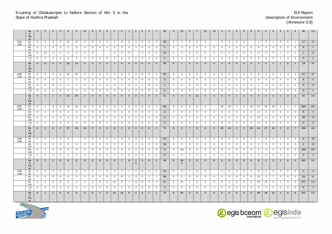
6-Laning of Chilakaluripet to Nellore Section of NH- 5 in the State of Andhra Pradesh
EIA Report Description of Environment
(Annexure 3.8)
Sub
Total
0 2 1 0 8 0 10 0 0 0 1 0 1 1 5 0 1 30 0 22 0 7 31 14 0 0 0 0 6 6 5 4 1 0 0 96 126
1281-1282
30-60
0 0 0 0 16 14 4 0 0 0 1 0 0 0 0 0 0 35 0 1 0 0 4 2 4 0 0 1 3 1 0 0 1 17 52
60-90
0 1 0 0 0 0 0 0 0 0 0 0 0 0 0 0 0 1 0 0 0 0 0 0 0 0 0 0 0 0 0 0 0 0 0 0 1
90-120
0 10 0 0 0 0 0 0 0 0 0 0 0 0 10 0 0 0 0 0 0 0 0 0 0 0 0 0 0 1 0 0 1 11
>120
0 0 0 0 0 0 0 0 0 0 0 0 0 0 0 0 0 0 0 0 0 0 0 0 0 0 0 0 0 0 0 0 0 0 0 0 0
Sub
Total
0 11 0 0 16 14 4 0 0 0 1 0 0 0 0 0 0 46 0 1 0 0 4 0 2 4 0 0 0 1 3 1 1 0 1 18 64
1282-1283
30-60
0 1 1 4 22 20 1 0 0 0 0 0 0 0 0 0 1 50 0 4 0 0 4 4 2 0 1 3 5 4 3 2 1 3 1 37 87
60-90
0 0 0 0 0 0 0 0 0 0 0 0 0 0 0 0 0 0 0 0 0 6 0 0 0 0 0 0 0 0 0 0 0 0 0 6 6
90-120
0 0 0 0 0 0 0 0 0 0 0 0 0 0 1 0 0 1 0 0 0 8 0 0 0 0 0 0 0 1 0 0 0 0 0 9 10
>120
0 0 0 0 0 0 0 0 0 0 0 0 0 0 0 0 0 0 0 0 0 0 0 0 0 0 0 0 0 0 0 0 0 0 0 0 0
Sub
Total
0 1 1 4 22 20 1 0 0 0 0 0 0 0 1 0 1 51 0 4 0 14 4 4 2 0 1 3 5 5 3 2 1 3 1 52 103
1283-1284
30-60
0 1 4 0 24 10 14 0 4 0 3 1 0 0 0 0 1 62 0 0 0 0 0 30 19 1 3 25 27 25 24 2 1 7 164 226
60-90
0 0 0 0 3 0 0 0 0 0 0 0 0 0 0 0 0 3 0 0 0 0 0 0 0 0 0 0 4 0 0 0 0 2 0 6 9
90-120
0 0 0 0 0 0 0 0 0 0 5 0 0 0 0 0 0 5 0 2 7 0 0 0 0 0 0 0 0 15 2 0 0 0 0 26 31
>120
0 0 0 0 0 0 0 0 0 0 0 0 0 0 0 0 0 0 0 0 0 0 0 0 0 0 0 0 0 0 0 0 0 0 0 0 0
Sub
Total
0 1 4 0 27 10 14 0 4 0 8 1 0 0 0 0 1 70 0 2 7 0 0 0 30 19 1 3 29 42 27 24 2 3 7 196 266
1284-1285
30-60
0 0 1 0 0 0 0 0 0 2 4 6 8 0 0 1 22 0 0 2 0 0 0 0 0 0 0 0 1 0 2 1 0 0 6 28
60-90
0 0 0 0 0 0 0 0 0 0 5 3 3 4 3 0 0 18 0 0 0 0 0 0 0 0 0 0 0 2 0 0 0 0 0 2 20
90-120
0 7 0 0 0 0 0 0 0 0 2 0 0 0 0 0 0 9 0 181 0 5 0 0 0 0 0 0 0 5 2 1 1 0 0 195 204
>120
0 0 0 0 0 0 0 0 0 0 0 0 0 0 0 0 0 0 0 0 0 0 0 0 0 0 0 0 0 0 0 0 0 0 0 0 0
Sub
Total
0 7 1 0 0 0 0 0 0 0 9 7 9 12
3 0 1 49 0 181
2 5 0 0 0 0 0 0 0 8 2 3 2 0 0 203 252
1285-1286
30-60
0 0 1 0 0 0 0 0 1 0 3 2 1 2 0 0 0 10 0 0 1 0 0 0 0 0 0 0 0 0 0 0 0 0 1 11
60-90
0 0 0 0 0 0 0 0 0 0 0 12 1 3 4 7 1 28 0 0 0 0 0 0 0 0 0 0 0 13 3 7 0 0 0 23 51
90-120
0 1 0 0 0 0 0 0 0 0 24 5 7 0 0 0 0 37 0 92 1 0 0 0 0 0 0 0 0 55 23 5 1 0 0 177 214
>120
0 0 0 0 0 0 0 0 0 0 0 0 0 0 0 0 0 0 0 0 0 0 0 0 0 0 0 0 0 0 0 0 0 0 0 0 0
Sub
Total
0 1 1 0 0 0 0 0 1 0 27 19 9 5 4 7 1 75 0 92 2 0 0 0 0 0 0 0 0 68 26 12 1 0 0 201 276

6-Laning of Chilakaluripet to Nellore Section of NH- 5 in the State of Andhra Pradesh
EIA Report Description of Environment
(Annexure 3.8)
1286-1287
30-60
0 1 0 1 3 0 0 0 0 5 1 0 0 0 0 1 12 0 0 0 0 20 8 3 0 0 0 14 4 1 0 0 0 0 50 62
60-90
0 0 0 0 0 0 0 0 0 0 0 2 0 0 0 0 0 2 0 0 0 0 0 0 0 0 0 0 4 1 0 0 0 0 0 5 7
90-120
0 0 0 0 0 0 0 0 0 0 2 2 2 0 0 0 0 6 0 0 0 1 0 0 0 0 0 0 2 1 7 0 1 7 0 19 25
>120
0 0 0 0 0 0 0 0 0 0 0 0 0 0 0 0 0 0 0 0 0 0 0 0 0 0 0 0 0 0 0 0 0 0 0 0 0
Sub
Total
0 1 0 1 3 0 0 0 0 0 7 5 2 0 0 0 1 20 0 0 0 1 20 8 3 0 0 0 20 6 8 0 1 7 0 74 94
1287-1288
30-60
0 0 10 0 155 50 4 0 0 0 1 0 1 1 1 0 2 225 1 0 3 0 145 67 0 0 0 0 0 1 1 0 0 0 0 218 443
60-90
0 0 0 1 0 0 0 0 0 0 0 0 0 0 0 0 0 1 0 0 0 0 0 0 0 0 0 0 0 0 0 0 0 0 0 0 1
90-120
0 0 0 0 0 0 0 0 0 0 0 0 0 0 0 0 0 0 0 2 0 0 0 0 0 0 0 0 0 0 0 0 0 0 0 2 2
>120
0 0 0 0 0 0 0 0 0 0 0 0 0 0 0 0 0 0 0 0 0 0 0 0 0 0 0 0 0 0 0 0 0 0 0 0 0
Sub
Total
0 0 10 1 155
50 4 0 0 0 1 0 1 1 1 0 2 226 1 2 3 0 145 67 0 0 0 0 0 1 1 0 0 0 0 220 446
1288-1289
30-60
1 0 0 0 111 43 0 0 0 0 0 1 1 0 0 0 1 158 0 0 31 0 56 39 0 0 1 0 1 1 1 1 1 1 0 133 291
60-90
0 0 0 0 0 0 0 0 0 0 0 0 0 0 0 0 0 0 0 0 0 0 0 0 0 0 0 0 0 4 0 0 0 0 0 4 4
90-120
0 0 0 0 0 0 0 0 0 0 0 0 0 0 0 0 0 0 0 0 0 0 0 0 0 0 0 0 0 1 0 0 1 0 0 2 2
>120
0 0 0 0 0 0 0 0 0 0 0 0 0 0 0 0 0 0 0 0 0 0 0 0 0 0 0 0 0 0 0 0 0 0 0 0 0
Sub
Total
1 0 0 0 111
43 0 0 0 0 0 1 1 0 0 0 1 158 0 0 31 0 56 39 0 0 1 0 1 6 1 1 2 1 0 139 297
1289-1290
30-60
0 0 0 0 27 12 0 0 0 0 1 2 4 6 0 0 0 52 0 0 11 0 48 12 0 0 0 89 3 4 1 2 8 3 3 184 236
60-90
0 0 0 4 3 0 0 0 0 0 0 0 0 0 0 0 0 7 0 0 0 7 7 0 0 0 0 0 0 0 0 0 0 0 0 14 21
90-120
0 6 0 0 0 0 0 0 0 0 0 21 4 0 0 0 0 31 0 0 0 0 0 0 0 0 0 0 34 2 1 2 2 1 1 43 74
>120
0 0 0 0 0 0 0 0 0 0 0 0 0 0 0 0 0 0 0 0 0 0 0 0 0 0 0 0 0 0 0 0 0 0 0 0 0
Sub
Total
0 6 0 4 30 12 0 0 0 0 1 23 8 6 0 0 0 90 0 0 11 7 55 12 0 0 0 89 37 6 2 4 10 4 4 241 331
1290-1291
30-60
0 0 2 3 0 0 0 0 1 0 0 0 0 0 0 2 8 0 0 3 0 1 3 0 0 1 0 2 5 7 1 7 0 0 30 38
60-90
0 0 0 0 0 0 0 0 0 0 30 0 0 0 0 0 0 30 0 0 0 0 0 0 0 0 0 0 0 20 0 0 0 0 20 50
90-120
0 47 0 0 0 0 0 0 0 0 0 0 0 0 0 0 0 47 0 68 0 10 0 0 0 0 0 0 0 5 0 0 0 0 0 83 130
>120
0 0 0 0 0 0 0 0 0 0 0 0 0 0 0 0 0 0 0 0 0 0 0 0 0 0 0 0 0 0 0 0 0 0 0 0 0
Sub
Total
0 47 2 3 0 0 0 0 0 1 30 0 0 0 0 0 2 85 0 68 3 10 1 3 0 0 1 0 2 30 7 1 7 0 0 133 218
1291-1292
30-60
0 0 2 0 0 0 0 0 2 1 2 1 0 0 0 0 8 0 0 2 0 0 0 0 2 0 2 0 0 0 0 0 0 2 8 16
60-90
0 0 0 1 0 0 0 2 0 5 0 3 2 0 0 3 2 18 0 0 0 2 0 0 0 0 0 0 5 5 1 0 0 0 0 13 31

6-Laning of Chilakaluripet to Nellore Section of NH- 5 in the State of Andhra Pradesh
EIA Report Description of Environment
(Annexure 3.8)
90-120
0 14 0 5 0 0 0 0 0 0 0 10 5 2 2 3 0 41 0 23 0 15 0 0 0 0 0 0 0 0 0 0 0 0 0 38 79
>120
0 0 0 0 0 0 0 0 0 0 0 0 0 0 0 0 0 0 0 0 0 0 0 0 0 0 0 0 0 0 0 0 0 0 0 0 0
Sub
Total
0 14 2 6 0 0 0 2 0 7 1 15 8 2 2 6 2 67 0 23 2 17 0 0 0 2 0 2 5 5 1 0 0 0 2 59 126
1292-1293
30-60
0 0 0 0 0 0 0 0 0 0 0 0 0 0 0 0 0 0 0 0 0 0 0 0 0 0 1 0 10 7 12 5 0 3 0 38 38
60-90
0 0 0 0 3 0 0 0 0 0 0 0 0 0 0 0 0 3 0 0 0 0 0 0 0 0 0 5 2 7 0 0 0 0 14 17
90-120
0 0 0 0 0 0 0 0 0 0 0 0 0 0 0 0 0 0 0 18 0 1 0 0 0 0 0 0 2 5 0 0 0 0 0 26 26
>120
0 0 0 0 0 0 0 0 0 0 0 0 0 0 0 0 0 0 0 0 0 0 0 0 0 0 0 0 0 0 0 0 0 0 0 0 0
Sub
Total
0 0 0 0 3 0 0 0 0 0 0 0 0 0 0 0 0 3 0 18 0 1 0 0 0 0 1 5 12 14 19 5 0 3 0 78 81
1293-1294
30-60
9 0 3 0 2 1 0 0 1 0 0 0 0 0 0 0 1 17 0 0 3 4 0 0 0 0 2 0 15 21 0 0 0 0 5 50 67
60-90
0 4 0 4 0 0 0 0 0 0 0 0 3 0 0 0 0 11 2 0 0 0 0 0 0 0 0 0 4 0 0 0 0 0 0 6 17
90-120
0 21 0 0 0 0 0 0 0 0 0 0 0 0 0 0 0 21 0 82 0 4 0 0 0 0 0 0 0 9 0 0 4 0 0 99 120
>120
0 0 0 0 0 0 0 0 0 0 0 0 0 0 0 0 0 0 0 0 0 0 0 0 0 0 0 0 0 0 0 0 0 0 0 0 0
Sub
Total
9 25 3 4 2 1 0 0 1 0 0 0 3 0 0 0 1 49 2 82 3 8 0 0 0 0 2 0 19 30 0 0 4 0 5 155 204
1294-1295
30-60
0 0 3 0 4 0 0 0 0 2 21 27 1 0 0 0 2 60 0 0 0 0 0 0 0 0 0 0 27 2 3 1 0 0 0 33 93
60-90
26 0 0 3 5 0 0 0 0 27 0 0 0 0 0 0 0 61 22 0 0 0 0 0 0 0 0 0 0 0 0 0 0 0 0 22 83
90-120
0 18 0 3 0 0 0 0 0 0 0 0 0 0 0 0 0 21 2 31 0 2 0 0 0 0 0 0 0 0 0 0 0 0 0 35 56
>120
0 0 0 0 0 0 0 0 0 0 0 0 0 0 0 0 0 0 0 0 0 0 0 0 0 0 0 0 0 0 0 0 0 0 0 0
Sub
Total
26 18 3 6 9 0 0 0 0 29 21 27 1 0 0 0 2 142 24 31 0 2 0 0 0 0 0 0 27 2 3 1 0 0 0 90 232
1295-1296
30-60
13 0 1 0 0 0 2 12 4 0 0 0 0 0 0 0 0 32 32 0 2 0 0 0 26 7 3 0 0 0 0 0 0 0 0 70 102
60-90
0 0 0 0 0 0 0 0 0 0 0 0 0 0 0 0 0 0 0 0 0 0 0 0 0 0 0 0 0 0 0 0 0 0 0 0 0
90-120
0 0 0 0 0 0 0 0 0 0 0 0 0 0 0 0 0 0 0 0 0 0 0 0 0 0 0 0 0 0 0 0 1 0 0 1 1
>120
0 0 0 0 0 0 0 0 0 0 0 0 0 0 0 0 0 0 0 0 0 0 0 0 0 0 0 0 0 0 0 0 0 0 0 0 0
Sub
Total
13 0 1 0 0 0 2 12 4 0 0 0 0 0 0 0 0 32 32 0 2 0 0 0 26 7 3 0 0 0 0 0 1 0 0 71 103
1296-1297
30-60
0 0 1 0 0 0 2 1 1 0 0 0 0 0 0 0 0 5 0 0 0 0 0 2 0 5 0 4 0 0 0 0 1 12 17
60-90
0 2 0 0 0 0 0 0 0 0 0 0 0 0 0 0 0 2 22 0 0 1 0 0 0 0 0 0 0 0 0 0 0 0 0 23 25
90-120
0 4 0 0 0 0 0 0 0 0 0 0 0 0 0 0 0 4 0 17 0 0 0 0 0 0 0 0 0 0 0 0 0 0 0 17 21
>120
0 0 0 0 0 0 0 0 0 0 0 0 0 0 0 0 0 0 0 0 0 0 0 0 0 0 0 0 0 0 0 0 0 0 0 0 0

6-Laning of Chilakaluripet to Nellore Section of NH- 5 in the State of Andhra Pradesh
EIA Report Description of Environment
(Annexure 3.8)
Sub
Total
0 6 1 0 0 0 2 1 1 0 0 0 0 0 0 0 0 11 22 17 0 1 0 0 2 0 5 0 0 4 0 0 0 0 1 52 63
1297-1298
30-60
0 0 1 0 10 5 0 1 0 0 10 23 2 0 0 0 2 54 2 0 6 0 0 0 0 0 2 0 1 2 3 1 1 0 2 20 74
60-90
0 0 0 0 0 0 0 0 0 0 0 12 0 0 0 0 0 12 0 0 0 0 0 0 0 0 0 0 0 0 0 0 0 2 0 2 14
90-120
0 2 0 0 0 0 0 0 0 0 0 6 0 0 0 0 0 8 0 17 0 9 0 0 0 0 0 0 0 0 0 0 1 0 0 27 35
>120
0 0 0 0 0 0 0 0 0 0 0 0 0 0 0 0 0 0 0 0 0 0 0 0 0 0 0 0 0 0 0 0 0 0 0 0 0
Sub
Total
0 2 1 0 10 5 0 1 0 0 10 41 2 0 0 0 2 74 2 17 6 9 0 0 0 0 2 0 1 2 3 1 2 2 2 49 123
1298-1299
30-60
0 0 5 0 4 0 0 0 1 0 11 2 1 1 0 0 2 27 2 0 9 1 0 1 0 3 2 0 10 7 0 0 0 0 2 37 64
60-90
25 11 23 0 15 4 0 4 16 0 0 8 0 0 0 8 0 114 0 0 0 3 0 0 0 0 0 0 0 0 0 0 0 0 0 3 117
90-120
0 1 0 0 0 0 0 0 0 0 1 1 6 0 1 5 2 17 0 3 0 0 0 0 0 0 0 0 0 0 0 0 0 0 0 3 20
>120
0 0 0 0 0 0 0 0 0 0 0 0 0 0 0 0 0 0 0 0 0 0 0 0 0 0 0 0 0 0 0 0 0 0 0 0 0
Sub
Total
25 12 28 0 19 4 0 4 17 0 12 11 7 1 1 13 4 158 2 3 9 4 0 1 0 3 2 0 10 7 0 0 0 0 2 43 201
1299-1300
30-60
5 0 0 0 4 0 1 0 0 0 0 0 0 0 0 0 2 12 38 0 13 0 0 52 0 1 0 1 1 0 0 0 0 1 107 119
60-90
1 17 0 0 0 0 0 0 0 0 0 0 0 0 0 0 0 18 0 0 0 0 0 0 0 0 0 0 0 0 0 0 0 0 0 0 18
90-120
0 35 0 0 0 0 0 0 0 0 0 0 0 0 0 0 0 35 0 0 0 0 0 0 4 0 0 0 0 0 0 0 0 0 0 4 39
>120
0 0 0 0 0 0 0 0 0 0 0 0 0 0 0 0 0 0 0 0 0 0 0 0 0 0 0 0 0 0 0 0 0 0 0 0 0
Sub
Total
6 52 0 0 4 0 1 0 0 0 0 0 0 0 0 0 2 65 38 0 13 0 0 0 56 0 1 0 1 1 0 0 0 0 1 111 176
1300-1301
30-60
9 0 2 1 38 30 1 0 0 1 1 0 0 0 0 0 0 83 27 0 0 0 0 0 48 2 0 2 2 12 4 0 0 0 2 99 182
60-90
1 18 0 0 0 0 0 0 0 0 0 0 0 0 0 0 0 19 5 0 0 0 0 0 0 0 0 0 0 0 0 0 0 0 0 5 24
90-120
0 26 0 0 0 0 0 0 0 0 0 0 0 0 0 0 0 26 0 9 0 4 0 0 0 0 0 0 1 0 0 0 0 0 0 14 40
>120
0 0 0 0 0 0 0 0 0 0 0 0 0 0 0 0 0 0 0 0 0 0 0 0 0 0 0 0 0 0 0 0 0 0 0 0 0
Sub
Total
10 44 2 1 38 30 1 0 0 1 1 0 0 0 0 0 0 128 32 9 0 4 0 0 48 2 0 2 3 12 4 0 0 0 2 118 246
1301-1302
30-60
4 0 0 0 6 0 2 3 0 20 11 2 4 1 0 0 4 57 0 0 2 0 2 2 15 1 3 3 14 5 2 0 0 9 2 60 117
60-90
4 0 0 7 0 0 0 0 0 0 0 0 0 0 0 0 0 11 0 0 0 9 1 0 0 0 0 0 0 0 0 0 0 0 0 10 21
90-120
2 8 0 10 0 0 0 0 0 0 0 5 0 0 1 8 0 34 0 1 0 9 0 0 4 0 0 0 0 0 0 0 0 0 0 14 48
>120
0 0 0 0 0 0 0 0 0 0 0 0 0 0 0 0 0 0 0 0 0 0 0 0 0 0 0 0 0 0 0 0 0 0 0 0 0
Sub
Total
10 8 0 17 6 0 2 3 0 20 11 7 4 1 1 8 4 102 0 1 2 18 3 2 19 1 3 3 14 5 2 0 0 9 2 84 186
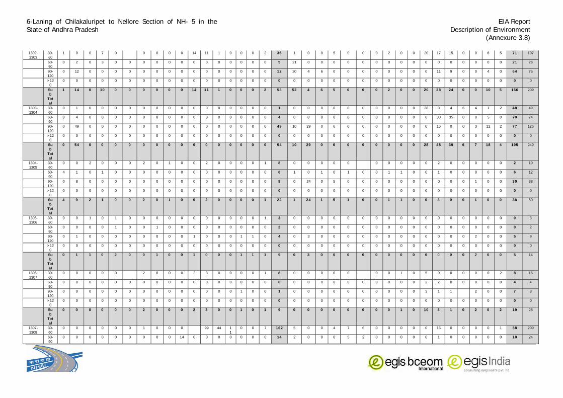
6-Laning of Chilakaluripet to Nellore Section of NH- 5 in the State of Andhra Pradesh
EIA Report Description of Environment
(Annexure 3.8)
1302-1303
30-60
1 0 0 7 0 0 0 0 0 14 11 1 0 0 0 2 36 1 0 0 5 0 0 0 2 0 0 20 17 15 0 0 6 5 71 107
60-90
0 2 0 3 0 0 0 0 0 0 0 0 0 0 0 0 0 5 21 0 0 0 0 0 0 0 0 0 0 0 0 0 0 0 0 21 26
90-120
0 12 0 0 0 0 0 0 0 0 0 0 0 0 0 0 0 12 30 4 6 0 0 0 0 0 0 0 0 11 9 0 0 4 0 64 76
>120
0 0 0 0 0 0 0 0 0 0 0 0 0 0 0 0 0 0 0 0 0 0 0 0 0 0 0 0 0 0 0 0 0 0 0 0 0
Sub
Total
1 14 0 10 0 0 0 0 0 0 14 11 1 0 0 0 2 53 52 4 6 5 0 0 0 2 0 0 20 28 24 0 0 10 5 156 209
1303-1304
30-60
0 1 0 0 0 0 0 0 0 0 0 0 0 0 0 0 0 1 0 0 0 0 0 0 0 0 0 0 28 3 4 6 4 1 2 48 49
60-90
0 4 0 0 0 0 0 0 0 0 0 0 0 0 0 0 0 4 0 0 0 0 0 0 0 0 0 0 0 30 35 0 0 5 0 70 74
90-120
0 49 0 0 0 0 0 0 0 0 0 0 0 0 0 0 0 49 10 29 0 6 0 0 0 0 0 0 0 15 0 0 3 12 2 77 126
>120
0 0 0 0 0 0 0 0 0 0 0 0 0 0 0 0 0 0 0 0 0 0 0 0 0 0 0 0 0 0 0 0 0 0 0 0 0
Sub
Total
0 54 0 0 0 0 0 0 0 0 0 0 0 0 0 0 0 54 10 29 0 6 0 0 0 0 0 0 28 48 39 6 7 18 4 195 249
1304-1305
30-60
0 0 2 0 0 0 2 0 1 0 0 2 0 0 0 0 1 8 0 0 0 0 0 0 0 0 0 0 2 0 0 0 0 0 2 10
60-90
4 1 0 1 0 0 0 0 0 0 0 0 0 0 0 0 0 6 1 0 1 0 1 0 0 1 1 0 0 1 0 0 0 0 0 6 12
90-120
0 8 0 0 0 0 0 0 0 0 0 0 0 0 0 0 0 8 0 24 0 5 0 0 0 0 0 0 0 0 0 0 1 0 0 30 38
>120
0 0 0 0 0 0 0 0 0 0 0 0 0 0 0 0 0 0 0 0 0 0 0 0 0 0 0 0 0 0 0 0 0 0 0 0 0
Sub
Total
4 9 2 1 0 0 2 0 1 0 0 2 0 0 0 0 1 22 1 24 1 5 1 0 0 1 1 0 0 3 0 0 1 0 0 38 60
1305-1306
30-60
0 0 1 0 1 0 0 0 0 0 0 0 0 0 0 0 1 3 0 0 0 0 0 0 0 0 0 0 0 0 0 0 0 0 0 0 3
60-90
0 0 0 0 1 0 0 1 0 0 0 0 0 0 0 0 0 2 0 0 0 0 0 0 0 0 0 0 0 0 0 0 0 0 0 0 2
90-120
0 1 0 0 0 0 0 0 0 0 1 0 0 0 1 1 0 4 0 3 0 0 0 0 0 0 0 0 0 0 0 0 2 0 0 5 9
>120
0 0 0 0 0 0 0 0 0 0 0 0 0 0 0 0 0 0 0 0 0 0 0 0 0 0 0 0 0 0 0 0 0 0 0 0 0
Sub
Total
0 1 1 0 2 0 0 1 0 0 1 0 0 0 1 1 1 9 0 3 0 0 0 0 0 0 0 0 0 0 0 0 2 0 0 5 14
1306-1307
30-60
0 0 0 0 0 2 0 0 0 2 3 0 0 0 0 1 8 0 0 0 0 0 0 0 1 0 5 0 0 0 0 0 2 8 16
60-90
0 0 0 0 0 0 0 0 0 0 0 0 0 0 0 0 0 0 0 0 0 0 0 0 0 0 0 0 2 2 0 0 0 0 0 4 4
90-120
0 0 0 0 0 0 0 0 0 0 0 0 0 0 1 0 0 1 0 0 0 0 0 0 0 0 0 0 3 1 1 2 0 0 7 8
>120
0 0 0 0 0 0 0 0 0 0 0 0 0 0 0 0 0 0 0 0 0 0 0 0 0 0 0 0 0 0 0 0 0 0 0 0 0
Sub
Total
0 0 0 0 0 0 2 0 0 0 2 3 0 0 1 0 1 9 0 0 0 0 0 0 0 0 1 0 10 3 1 0 2 0 2 19 28
1307-1308
30-60
0 0 0 0 0 0 1 0 0 0 99 44 11
0 0 7 162 5 0 0 4 7 6 0 0 0 0 0 15 0 0 0 0 1 38 200
60-90
0 0 0 0 0 0 0 0 0 14 0 0 0 0 0 0 0 14 2 0 0 0 5 2 0 0 0 0 0 1 0 0 0 0 0 10 24

6-Laning of Chilakaluripet to Nellore Section of NH- 5 in the State of Andhra Pradesh
EIA Report Description of Environment
(Annexure 3.8)
90-120
0 0 0 0 0 0 0 0 0 0 8 2 2 0 0 0 0 12 0 0 0 0 0 0 0 0 0 0 0 0 0 0 2 2 0 4 16
>120
0 0 0 0 0 0 0 0 0 0 0 0 0 0 0 0 0 0 0 0 0 0 0 0 0 0 0 0 0 0 0 0 0 0 0 0 0
Sub
Total
0 0 0 0 0 0 1 0 0 14 8 101
46 11
0 0 7 188 7 0 0 4 12 8 0 0 0 0 0 16 0 0 2 2 1 52 240
District Total ##
634
##
173
## 2211
846
203
##
127
##
##
218
73
47
91 136
11111
1107
797
##
##
###
###
##
236
189
180
597
##
352
131
106
##
156
###
25080
NELLORE DISTRICT1308-1309
30-60
0 0 0 0 26 20 0 0 0 0 2 6 0 0 0 0 1 55 4 0 5 0 15 16 0 0 0 0 0 0 0 0 0 0 1 41 96
60-90
0 0 0 0 5 1 0 0 0 0 0 1 0 0 0 0 0 7 0 0 0 0 0 0 0 0 0 0 0 5 2 0 0 0 0 7 14
90-120
0 0 0 0 1 0 0 0 0 0 0 2 0 0 0 4 0 7 2 1 0 6 5 0 0 0 0 0 0 0 0 0 2 4 0 20 27
>120
0 0 0 0 0 0 0 0 0 0 0 0 0 0 0 0 0 0 0 0 0 0 0 0 0 0 0 0 0 0 0 0 0 0 0 0 0
Sub
Total
0 0 0 0 32 21 0 0 0 0 2 9 0 0 0 4 1 69 6 1 5 6 20 16 0 0 0 0 0 5 2 0 2 4 1 68 137
1309-1310
30-60
0 0 0 0 0 0 0 0 0 0 0 0 0 0 0 0 1 1 0 0 0 0 3 0 0 0 0 0 0 0 0 0 0 0 3 4
60-90
0 0 0 0 0 0 0 0 0 0 0 0 0 0 0 0 0 0 0 0 0 0 2 0 0 0 1 0 0 0 0 0 0 0 0 3 3
90-120
0 0 0 0 0 0 0 0 0 0 0 0 0 0 0 0 0 0 0 5 8 0 1 0 0 0 0 0 0 1 1 0 2 2 0 20 20
>120
0 0 0 0 0 0 0 0 0 0 0 0 0 0 0 0 0 0 0 0 0 0 0 0 0 0 0 0 0 0 0 0 0 0 0 0 0
Sub
Total
0 0 0 0 0 0 0 0 0 0 0 0 0 0 0 0 1 1 0 5 8 0 6 0 0 0 1 0 0 1 1 0 2 2 0 26 27
1310-1311
30-60
0 0 0 0 3 1 0 0 1 0 0 0 0 0 0 0 0 5 0 0 2 0 7 3 0 1 0 0 12 4 12 0 0 0 3 44 49
60-90
0 0 0 0 1 0 0 0 0 0 0 0 0 0 0 0 0 1 0 0 5 0 7 7 0 2 0 0 0 0 0 0 0 0 0 21 22
90-120
0 2 0 0 1 0 0 0 0 0 0 0 0 0 0 0 0 3 0 34 0 2 2 0 0 0 0 0 0 0 0 0 0 0 0 38 41
>120
0 0 0 0 0 0 0 0 0 0 0 0 0 0 0 0 0 0 0 0 0 0 0 0 0 0 0 0 0 0 0 0 0 0 0 0 0
Sub
Total
0 2 0 0 5 1 0 0 1 0 0 0 0 0 0 0 0 9 0 34 7 2 16 10 0 3 0 0 12 4 12 0 0 0 3 103 112
1311-1312
30-60
0 0 0 0 6 5 0 0 7 1 0 2 1 0 0 0 1 23 0 0 10 0 37 0 0 0 5 1 5 4 3 0 0 0 3 68 91
60-90
0 0 0 1 3 0 0 0 0 0 0 0 0 0 0 0 0 4 0 0 0 0 0 0 0 0 0 0 0 10 2 0 0 0 0 12 16
90-120
0 2 0 2 3 0 0 0 0 0 0 0 0 0 0 0 0 7 0 20 4 1 2 0 0 0 0 0 0 0 0 0 2 4 0 33 40
>120
0 0 0 0 0 0 0 0 0 0 0 0 0 0 0 0 0 0 0 0 0 0 0 0 0 0 0 0 0 0 0 0 0 0 0 0 0
Sub
Total
0 2 0 3 12 5 0 0 7 1 0 2 1 0 0 0 1 34 0 20 14 1 39 0 0 0 5 1 5 14 5 0 2 4 3 113 147
1312-1313
30-60
0 0 0 0 4 0 0 0 1 0 2 0 0 0 0 1 8 2 0 8 0 1 20 2 0 1 0 2 1 2 2 0 0 2 43 51
60-90
0 0 0 0 0 0 0 0 0 0 2 0 0 0 0 0 0 2 0 0 0 0 11 0 0 0 0 0 0 0 0 0 0 0 0 11 13

6-Laning of Chilakaluripet to Nellore Section of NH- 5 in the State of Andhra Pradesh
EIA Report Description of Environment
(Annexure 3.8)
90-120
0 9 0 1 0 0 0 0 0 0 0 0 0 0 0 5 0 15 0 6 0 9 0 0 0 0 0 0 0 2 0 0 0 0 0 17 32
>120
0 0 0 0 0 0 0 0 0 0 0 0 0 0 0 0 0 0 0 0 0 0 0 0 0 0 0 0 0 0 0 0 0 0 0 0 0
Sub
Total
0 9 0 1 4 0 0 0 0 1 2 2 0 0 0 5 1 25 2 6 8 9 12 20 2 0 1 0 2 3 2 2 0 0 2 71 96
1313-1314
30-60
0 0 0 0 10 0 20 0 0 10 0 3 0 0 0 0 1 44 0 0 3 0 19 6 0 0 1 0 0 0 0 0 0 0 1 30 74
60-90
0 0 0 0 0 0 0 0 4 0 0 0 0 0 0 0 0 4 0 0 0 0 0 0 0 0 0 0 0 0 0 0 0 6 0 6 10
90-120
0 0 0 0 0 0 0 0 0 0 0 5 0 0 6 0 0 11 0 1 0 3 0 0 0 0 0 0 0 4 2 0 0 2 0 12 23
>120
0 0 0 0 0 0 0 0 0 0 0 0 0 0 0 0 0 0 0 0 0 0 0 0 0 0 0 0 0 0 0 0 0 0 0 0 0
Sub
Total
0 0 0 0 10 0 20 0 4 10 0 8 0 0 6 0 1 59 0 1 3 3 19 6 0 0 1 0 0 4 2 0 0 8 1 48 107
1314-1315
30-60
0 0 0 0 22 20 9 1 13 0 1 2 1 1 0 0 2 72 0 0 14 0 39 0 2 25 0 11 0 0 0 0 0 2 93 165
60-90
0 0 0 0 0 0 0 0 0 0 0 7 0 0 0 0 0 7 0 0 0 0 0 0 0 0 0 0 2 5 5 0 0 0 0 12 19
90-120
0 9 0 0 0 0 0 0 0 0 0 0 0 0 1 0 0 10 0 5 0 0 0 0 0 0 0 0 0 4 0 0 0 0 0 9 19
>120
0 0 0 0 0 0 0 0 0 0 0 0 0 0 0 0 0 0 0 0 0 0 0 0 0 0 0 0 0 0 0 0 0 0 0 0 0
Sub
Total
0 9 0 0 22 20 9 1 13 0 1 9 1 1 1 0 2 89 0 5 14 0 39 0 0 2 25 0 13 9 5 0 0 0 2 114 203
1315-1316
30-60
0 0 0 0 30 34 38 1 35 0 14 5 0 0 0 0 5 162 0 0 4 0 40 27 1 1 45 0 0 0 0 0 0 0 0 118 280
60-90
0 1 0 0 0 0 0 0 0 0 0 2 0 0 0 0 0 3 2 3 0 0 0 0 0 1 0 0 2 0 0 0 0 0 0 8 11
90-120
0 32 0 0 0 0 0 0 0 0 0 0 0 0 0 0 0 32 0 60 0 0 0 0 0 0 0 0 0 0 0 0 0 0 0 60 92
>120
0 0 0 0 0 0 0 0 0 0 0 0 0 0 0 0 0 0 0 0 0 0 0 0 0 0 0 0 0 0 0 0 0 0 0 0 0
Sub
Total
0 33 0 0 30 34 38 1 35 0 14 7 0 0 0 0 5 197 2 63 4 0 40 27 1 2 45 0 2 0 0 0 0 0 0 186 383
1316-1317
30-60
5 0 0 3 32 30 36 0 24 0 9 6 5 0 0 0 1 151 5 0 3 0 29 25 6 1 55 0 10 3 1 0 0 0 0 138 289
60-90
0 0 0 0 0 0 0 0 0 0 0 0 0 0 0 0 0 0 0 5 0 0 0 0 0 0 0 0 0 0 0 0 0 0 0 5 5
90-120
0 70 0 0 0 0 0 0 0 0 0 0 0 0 0 0 0 70 0 53 0 0 0 0 0 0 0 0 0 0 0 0 0 0 0 53 123
>120
0 0 0 0 0 0 0 0 0 0 0 0 0 0 0 0 0 0 0 0 0 0 0 0 0 0 0 0 0 0 0 0 0 0 0 0 0
Sub
Total
5 70 0 3 32 30 36 0 24 0 9 6 5 0 0 0 1 221 5 58 3 0 29 25 6 1 55 0 10 3 1 0 0 0 0 196 417
1317-1318
30-60
8 0 2 2 100 36 0 0 12 0 0 5 2 0 0 0 0 167 0 0 0 0 79 0 0 13 0 2 0 0 0 0 0 4 98 265
60-90
0 2 0 0 0 0 0 0 0 0 0 0 0 0 0 0 0 2 2 0 0 0 9 0 0 2 0 0 0 0 0 0 0 0 0 13 15
90-120
0 41 0 0 0 0 0 0 0 0 0 0 0 0 0 0 0 41 0 8 0 0 0 0 0 0 0 0 0 0 0 0 0 0 0 8 49
>120
0 0 0 0 0 0 0 0 0 0 0 0 0 0 0 0 0 0 0 0 0 0 0 0 0 0 0 0 0 0 0 0 0 0 0 0 0

6-Laning of Chilakaluripet to Nellore Section of NH- 5 in the State of Andhra Pradesh
EIA Report Description of Environment
(Annexure 3.8)
Sub
Total
8 43 2 2 100
36 0 0 12 0 0 5 2 0 0 0 0 210 2 8 0 0 88 0 0 2 13 0 2 0 0 0 0 0 4 119 329
1318-1319
30-60
0 5 0 0 31 30 0 0 3 0 0 0 0 0 0 0 0 69 0 0 0 0 42 20 0 2 0 0 0 0 0 0 0 0 0 64 133
60-90
0 0 0 0 0 0 0 0 0 0 0 0 0 0 0 0 0 0 0 0 0 0 0 0 0 0 0 0 0 0 0 0 0 0 0 0
90-120
0 52 0 0 0 0 0 0 0 0 0 0 0 0 0 0 0 52 0 60 0 0 0 0 0 0 0 0 0 0 0 0 0 0 0 60 112
>120
0 0 0 0 0 0 0 0 0 0 0 0 0 0 0 0 0 0 0 0 0 0 0 0 0 0 0 0 0 0 0 0 0 0 0 0 0
Sub
Total
0 57 0 0 31 30 0 0 3 0 0 0 0 0 0 0 0 121 0 60 0 0 42 20 0 2 0 0 0 0 0 0 0 0 0 124 245
1319-1320
30-60
0 0 0 0 9 9 0 0 25 0 0 0 0 0 0 0 0 43 0 0 0 0 19 0 0 0 0 2 1 1 0 0 0 1 24 67
60-90
0 0 0 0 0 0 0 0 0 0 0 0 0 0 0 0 0 0 0 0 0 0 2 0 0 0 0 0 0 0 0 0 0 0 0 2 2
90-120
0 3 0 0 0 0 0 0 0 0 0 0 0 0 0 0 0 3 0 2 0 0 0 0 0 0 0 0 0 0 0 0 0 0 0 2 5
>120
0 0 0 0 0 0 0 0 0 0 0 0 0 0 0 0 0 0 0 0 0 0 0 0 0 0 0 0 0 0 0 0 0 0 0 0 0
Sub
Total
0 3 0 0 9 9 0 0 25 0 0 0 0 0 0 0 0 46 0 2 0 0 21 0 0 0 0 0 2 1 1 0 0 0 1 28 74
1320-1321
30-60
0 0 0 0 3 0 0 2 0 0 0 0 0 0 0 0 0 5 0 0 0 0 6 12 0 2 0 0 9 0 0 0 0 0 1 30 35
60-90
0 0 0 0 0 0 0 0 0 0 0 0 0 0 0 0 0 0 0 0 0 0 0 0 0 0 0 0 0 0 0 0 0 0 0 0 0
90-120
0 21 0 0 0 0 0 0 0 0 0 0 0 0 0 0 0 21 0 11 0 0 0 0 0 0 0 0 0 0 0 0 0 0 0 11 32
>120
0 0 0 0 0 0 0 0 0 0 0 0 0 0 0 0 0 0 0 0 0 0 0 0 0 0 0 0 0 0 0 0 0 0 0 0 0
Sub
Total
0 21 0 0 3 0 0 2 0 0 0 0 0 0 0 0 0 26 0 11 0 0 6 12 0 2 0 0 9 0 0 0 0 0 1 41 67
1321-1322
30-60
0 0 1 0 2 0 0 0 3 0 0 0 0 0 0 0 2 8 0 0 0 0 0 0 0 17 0 5 6 3 2 0 0 1 34 42
60-90
0 0 0 0 0 0 0 0 0 0 0 0 0 0 0 0 0 0 0 0 0 0 0 0 0 0 0 0 0 0 0 0 0 0 0 0 0
90-120
0 4 0 0 0 0 0 0 0 0 0 0 0 0 0 0 0 4 0 31 0 0 0 0 0 0 0 0 0 0 0 0 0 0 0 31 35
>120
0 0 0 0 0 0 0 0 0 0 0 0 0 0 0 0 0 0 0 0 0 0 0 0 0 0 0 0 0 0 0 0 0 0 0 0 0
Sub
Total
0 4 1 0 2 0 0 0 3 0 0 0 0 0 0 0 2 12 0 31 0 0 0 0 0 0 17 0 5 6 3 2 0 0 1 65 77
1322-1323
30-60
0 0 0 0 1 0 0 1 3 0 0 0 0 0 0 1 6 0 2 0 2 50 30 0 0 5 0 5 2 1 0 0 0 0 97 103
60-90
0 0 0 0 0 0 0 0 0 0 0 0 0 0 0 0 0 0 0 1 0 0 0 0 0 0 0 0 0 0 0 0 0 0 0 1 1
90-120
0 23 0 0 0 0 0 0 0 0 0 3 0 0 2 0 0 28 0 15 0 0 0 0 0 0 0 0 0 0 0 0 0 0 0 15 43
>120
0 0 0 0 0 0 0 0 0 0 0 0 0 0 0 0 0 0 0 0 0 0 0 0 0 0 0 0 0 0 0 0 0 0 0 0 0
Sub
Total
0 23 0 0 1 0 0 0 1 3 0 3 0 0 2 0 1 34 0 18 0 2 50 30 0 0 5 0 5 2 1 0 0 0 0 113 147

6-Laning of Chilakaluripet to Nellore Section of NH- 5 in the State of Andhra Pradesh
EIA Report Description of Environment
(Annexure 3.8)
1323-1324
30-60
0 0 0 0 13 0 0 0 2 0 0 0 0 0 0 0 0 15 0 0 0 0 20 14 0 0 2 0 0 5 3 0 0 0 1 45 60
60-90
0 0 0 0 0 0 0 0 0 0 0 0 0 0 0 0 0 0 0 0 0 0 0 0 0 0 0 0 0 0 0 0 0 0 0 0 0
90-120
0 0 0 0 0 0 0 0 0 0 0 0 0 0 0 0 0 0 0 3 0 0 0 0 0 0 0 0 0 0 0 0 0 0 3 3
>120
0 0 0 0 0 0 0 0 0 0 0 0 0 0 0 0 0 0 0 0 0 0 0 0 0 0 0 0 0 0 0 0 0 0 0 0 0
Sub
Total
0 0 0 0 13 0 0 0 2 0 0 0 0 0 0 0 0 15 0 3 0 0 20 14 0 0 2 0 0 5 3 0 0 0 1 48 63
1324-1325
30-60
0 0 2 0 180 7 0 1 48 0 0 0 0 0 0 0 2 240 0 0 71 0 0 0 0 0 15 0 0 0 0 0 0 0 1 87 327
60-90
0 0 0 0 11 0 0 0 0 0 0 0 0 0 0 0 0 11 0 0 0 0 0 0 0 0 0 0 0 0 0 0 0 0 0 0 11
90-120
0 1 0 1 0 0 0 0 0 0 0 3 0 0 0 0 0 5 0 1 0 0 0 0 0 0 0 0 0 0 0 0 0 0 0 1 6
>120
0 0 0 0 0 0 0 0 0 0 0 0 0 0 0 0 0 0 0 0 0 0 0 0 0 0 0 0 0 0 0 0 0 0 0 0 0
Sub
Total
0 1 2 1 191
7 0 1 48 0 0 3 0 0 0 0 2 256 0 1 71 0 0 0 0 0 15 0 0 0 0 0 0 0 1 88 344
1325-1326
0 0 0 0 29 0 0 1 24 0 0 0 0 0 0 0 0 54 0 0 2 0 99 49 1 0 37 0 0 5 0 0 0 0 1 194 248
0 0 0 0 6 0 0 0 0 0 0 0 0 0 0 0 0 6 0 0 0 0 0 0 0 0 0 0 0 0 0 0 0 0 0 0 6
0 0 0 0 0 0 0 0 0 0 0 0 0 0 1 0 0 1 0 0 0 0 0 0 0 0 0 0 0 0 0 0 0 0 0 0 1
0 0 0 0 0 0 0 0 0 0 0 0 0 0 0 0 0 0 0 0 0 0 0 0 0 0 0 0 0 0 0 0 0 0 0 0 0
Sub
Total
0 0 0 0 35 0 0 1 24 0 0 0 0 0 1 0 0 61 0 0 2 0 99 49 1 0 37 0 0 5 0 0 0 0 1 194 255
1326-1327
30-60
0 0 0 0 23 20 0 1 6 0 0 0 0 0 0 0 1 51 0 0 0 0 10 9 0 0 2 0 0 0 0 0 0 0 0 21 72
60-90
0 0 0 0 6 0 0 0 0 0 0 0 0 0 0 0 0 6 0 0 0 0 6 0 0 0 0 0 0 0 0 0 0 0 0 6 12
90-120
0 0 0 0 0 0 0 0 0 0 0 0 0 0 1 0 0 1 0 0 0 0 0 0 0 0 0 0 0 0 0 0 1 0 0 1 2
>120
0 0 0 0 0 0 0 0 0 0 0 0 0 0 0 0 0 0 0 0 0 0 0 0 0 0 0 0 0 0 0 0 0 0 0 0 0
Sub
Total
0 0 0 0 29 20 0 1 6 0 0 0 0 0 1 0 1 58 0 0 0 0 16 9 0 0 2 0 0 0 0 0 1 0 0 28 86
1327-1328
30-60
0 0 0 0 0 0 0 0 7 0 0 0 0 0 0 0 0 7 0 0 0 0 0 0 0 0 0 0 0 0 0 0 1 0 0 1 8
60-90
0 0 0 0 0 0 0 0 0 0 0 0 0 0 1 0 0 1 0 0 0 0 0 0 0 0 0 0 0 0 0 0 1 0 0 1 2
90-120
0 1 0 0 1 0 0 0 0 0 0 0 0 0 0 0 0 2 0 0 0 0 0 0 0 0 0 0 0 0 0 0 1 0 0 1 3
>120
0 0 0 0 0 0 0 0 0 0 0 0 0 0 1 0 0 1 0 0 0 0 0 0 0 0 0 0 0 0 0 0 1 0 0 1 2
Sub
Total
0 1 0 0 1 0 0 0 7 0 0 0 0 0 2 0 0 11 0 0 0 0 0 0 0 0 0 0 0 0 0 0 4 0 0 4 15
1328-1329
30-60
0 0 0 0 20 1 0 0 4 0 0 0 0 0 0 0 0 25 0 0 0 0 0 0 0 0 4 4 0 0 0 0 0 0 0 8 33
60-90
0 0 0 3 0 0 0 0 0 0 0 0 0 0 0 0 0 3 0 0 0 0 1 0 0 0 0 0 5 2 0 0 0 0 0 8 11
90-120
2 8 0 7 0 0 0 0 0 0 7 1 0 0 0 0 0 25 0 26 0 8 0 0 0 1 0 0 0 0 0 0 0 0 0 35 60

6-Laning of Chilakaluripet to Nellore Section of NH- 5 in the State of Andhra Pradesh
EIA Report Description of Environment
(Annexure 3.8)
>120
0 0 0 0 0 0 0 0 0 0 0 0 0 0 0 0 0 0 0 0 0 0 0 0 0 0 0 0 0 0 0 0 1 0 0 1 1
Sub
Total
2 8 0 10 20 1 0 0 4 0 7 1 0 0 0 0 0 53 0 26 0 8 1 0 0 1 4 4 5 2 0 0 1 0 0 52 105
1329-1330
1 0 0 0 5 0 0 0 2 0 0 0 0 0 0 0 1 9 0 0 2 0 15 0 0 0 0 2 0 0 0 0 0 0 0 19 28
2 0 0 0 0 0 0 0 0 0 0 0 0 0 0 0 0 2 0 0 0 0 1 0 0 0 0 0 0 0 0 0 0 0 0 1 3
0 0 0 1 0 0 0 0 0 0 0 0 0 0 0 0 0 1 0 2 0 3 0 0 0 0 0 0 0 0 0 0 1 0 0 6 7
0 0 0 0 0 0 0 0 0 0 0 0 0 0 0 0 0 0 0 0 0 0 0 0 0 0 0 0 0 0 0 0 0 0 0 0 0
Sub
Total
3 0 0 1 5 0 0 0 2 0 0 0 0 0 0 0 1 12 0 2 2 3 16 0 0 0 0 2 0 0 0 0 1 0 0 26 38
1330-1331
30-60
0 0 0 0 7 0 0 0 0 3 0 0 0 0 0 0 0 10 0 0 2 0 5 0 0 0 1 0 0 0 0 0 0 0 3 11 21
60-90
0 0 0 0 0 0 0 0 0 0 0 0 0 0 0 0 0 0 0 0 0 0 0 0 0 0 0 0 0 0 0 0 0 0 0 0 0
90-120
0 7 0 0 2 0 0 0 0 0 1 2 0 0 1 1 0 14 0 2 0 0 1 0 0 0 0 0 0 0 0 0 0 0 0 3 17
>120
0 0 0 0 0 0 0 0 0 0 0 0 0 0 0 0 0 0 0 0 0 0 0 0 0 0 0 0 0 0 0 0 0 0 0 0 0
Sub
Total
0 7 0 0 9 0 0 0 0 3 1 2 0 0 1 1 0 24 0 2 2 0 6 0 0 0 1 0 0 0 0 0 0 0 3 14 38
1331-1332
30-60
0 0 0 0 8 0 0 2 1 0 0 0 0 0 0 0 11 0 0 5 0 9 0 0 8 0 10 2 0 0 0 0 0 34 45
60-90
0 0 0 0 0 0 0 0 0 0 0 0 0 0 0 0 0 0 0 0 0 7 6 0 0 0 0 0 0 0 0 0 0 0 0 13 13
90-120
0 9 0 0 0 0 0 0 0 0 3 0 0 0 0 0 0 12 0 23 0 2 0 0 0 0 0 0 0 0 0 0 0 0 0 25 37
>120
0 0 0 0 0 0 0 0 0 0 0 0 0 0 0 0 0 0 0 0 0 0 0 0 0 0 0 0 0 0 0 0 0 0 0 0
Sub
Total
0 9 0 0 8 0 0 0 2 1 3 0 0 0 0 0 0 23 0 23 5 9 15 0 0 0 8 0 10 2 0 0 0 0 0 72 95
1332-1333
30-60
8 0 1 0 0 0 0 0 0 4 1 2 0 0 0 1 17 0 0 0 0 10 0 0 0 0 0 4 6 0 0 0 0 2 22 39
60-90
0 0 0 0 0 0 0 0 0 0 0 0 0 0 0 0 0 0 0 0 0 0 0 0 0 0 0 0 0 0 0 0 0 10 0 10 10
90-120
0 3 0 2 0 0 0 0 0 0 0 3 0 0 0 0 0 8 0 4 0 0 1 0 0 0 0 0 0 0 0 0 0 0 0 5 13
>120
0 0 0 0 0 0 0 0 0 0 0 0 0 0 0 0 0 0 0 0 0 0 0 0 0 0 0 0 0 0 0 0 0 0 0 0 0
Sub
Total
8 3 1 2 0 0 0 0 0 0 4 4 2 0 0 0 1 25 0 4 0 0 11 0 0 0 0 0 4 6 0 0 0 10 2 37 62
1333-1334
30-60
2 0 0 4 0 0 0 0 0 0 0 0 0 0 0 2 8 0 0 0 3 0 0 0 1 0 0 0 0 0 0 0 0 4 12
60-90
1 0 0 0 0 0 0 0 0 0 0 0 0 0 0 0 0 1 0 0 0 0 0 0 0 0 0 0 0 0 0 0 0 0 0 0 1
90-120
1 0 0 0 0 0 0 0 0 0 0 0 0 0 0 0 0 1 0 3 0 0 0 0 0 0 0 0 0 0 0 0 0 0 0 3 4
>120
0 0 0 0 0 0 0 0 0 0 0 0 0 0 0 0 0 0 0 0 0 0 0 0 0 0 0 0 0 0 0 0 0 0 0 0 0
Sub
Total
4 0 0 4 0 0 0 0 0 0 0 0 0 0 0 0 2 10 0 3 0 3 0 0 0 0 1 0 0 0 0 0 0 0 0 7 17

6-Laning of Chilakaluripet to Nellore Section of NH- 5 in the State of Andhra Pradesh
EIA Report Description of Environment
(Annexure 3.8)
1334-1335
30-60
0 0 0 0 0 0 0 4 1 0 0 0 0 0 0 1 6 0 0 0 0 0 0 0 0 1 0 0 0 0 0 0 2 3 9
60-90
0 0 0 0 0 0 0 0 0 0 0 0 0 0 0 0 0 0 0 0 0 0 0 0 0 0 0 3 0 0 0 0 0 0 0 3 3
90-120
0 0 0 1 0 0 0 0 0 0 1 0 0 0 0 0 0 2 0 23 0 0 0 0 0 0 0 0 0 0 0 0 0 0 0 23 25
>120
0 0 0 0 0 0 0 0 0 0 0 0 0 0 0 0 0 0 0 0 0 0 0 0 0 0 0 0 0 0 0 0 0 0 0 0 0
Sub
Total
0 0 0 1 0 0 0 0 4 1 1 0 0 0 0 0 1 8 0 23 0 0 0 0 0 0 0 4 0 0 0 0 0 0 2 29 37
1335-1336
30-60
0 0 1 0 3 0 0 0 0 0 0 0 0 0 0 0 0 4 0 0 0 1 56 0 0 0 0 0 0 0 0 0 0 1 58 62
60-90
0 0 0 1 0 0 0 0 0 0 0 0 0 0 0 0 0 1 0 0 0 0 0 0 0 0 0 0 0 0 0 0 0 0 0 0 1
90-120
0 4 0 0 0 0 0 0 0 0 0 0 0 0 0 0 0 4 0 0 0 0 0 0 0 0 0 0 0 0 0 1 4 0 5 9
>120
0 0 0 0 0 0 0 0 0 0 0 0 0 0 0 0 0 0 0 0 0 0 0 0 0 0 0 0 0 0 0 0 0 0 0 0 0
Sub
Total
0 4 1 1 3 0 0 0 0 0 0 0 0 0 0 0 0 9 0 0 0 1 56 0 0 0 0 0 0 0 0 0 1 4 1 63 72
1336-1337
30-60
2 0 0 0 5 0 3 0 0 1 1 0 0 0 0 1 13 0 0 0 0 1 0 0 0 1 0 0 0 0 0 0 0 2 15
60-90
0 0 0 0 0 0 0 0 0 0 0 5 0 0 0 0 0 5 0 0 0 0 0 0 0 0 0 12 2 5 2 0 0 1 0 22 27
90-120
0 1 0 1 0 0 0 0 0 0 0 3 0 0 0 0 0 5 0 0 0 0 0 0 0 0 0 0 0 0 0 0 0 11 0 11 16
>120
0 0 0 0 0 0 0 0 0 0 0 0 0 0 0 0 0 0 0 0 0 0 0 0 0 0 0 0 0 0 0 0 0 0 0 0 0
Sub
Total
2 1 0 1 5 0 0 3 0 0 1 9 0 0 0 0 1 23 0 0 0 0 1 0 0 0 0 13 2 5 2 0 0 12 0 35 58
1337-1338
30-60
0 0 1 0 3 0 0 18 0 3 1 0 0 0 0 1 27 0 0 0 0 5 0 0 0 0 0 0 0 0 0 0 3 8 35
60-90
0 0 0 0 0 0 0 0 0 0 0 0 0 0 0 0 0 0 0 0 0 0 0 0 0 0 4 0 0 0 0 0 0 0 0 4 4
90-120
0 0 0 0 0 0 0 0 0 0 0 0 0 0 0 0 0 0 0 0 0 0 0 0 0 0 0 0 0 0 0 0 0 0 0 0 0
>120
0 0 0 0 0 0 0 0 0 0 0 0 0 0 0 0 0 0 0 0 0 0 0 0 0 0 0 0 0 0 0 0 0 0 0 0 0
Sub
Total
0 0 1 0 3 0 0 0 18 0 3 1 0 0 0 0 1 27 0 0 0 0 5 0 0 0 4 0 0 0 0 0 0 0 3 12 39
1338-1339
30-60
0 0 1 0 3 0 0 12 0 1 8 2 2 0 0 2 31 0 0 0 0 6 0 0 2 0 1 2 2 7 0 0 2 22 53
60-90
0 0 0 0 0 0 0 0 0 0 4 0 0 0 0 0 4 0 0 0 0 0 0 0 0 0 0 0 3 0 0 0 0 0 3 7
90-120
0 0 0 1 0 0 0 0 0 0 0 2 0 0 0 0 0 3 0 0 0 0 0 0 0 0 0 0 0 0 0 0 1 0 0 1 4
>120
0 0 0 0 0 0 0 0 0 0 0 0 0 0 0 0 0 0 0 0 0 0 0 0 0 0 0 0 0 0 0 0 0 0 0 0 0
Sub
Total
0 0 1 1 3 0 0 0 12 0 1 14 2 2 0 0 2 38 0 0 0 0 6 0 0 0 2 0 1 5 2 7 1 0 2 26 64
1339-1340
30-60
0 0 3 0 0 0 0 0 0 0 8 0 0 0 0 0 2 13 0 0 0 0 3 0 0 0 0 13 20 21 5 6 0 2 70 83
60-90
0 0 0 0 0 0 0 0 0 0 6 0 0 0 0 0 0 6 0 0 0 0 0 0 0 0 0 0 0 0 0 0 0 15 0 15 21

6-Laning of Chilakaluripet to Nellore Section of NH- 5 in the State of Andhra Pradesh
EIA Report Description of Environment
(Annexure 3.8)
90-120
0 0 0 2 0 0 0 0 0 0 0 0 0 0 0 0 0 2 0 0 0 0 0 0 0 0 0 0 0 1 4 4 2 9 1 21 23
>120
0 0 0 0 0 0 0 0 0 0 0 0 0 0 0 0 0 0 0 0 0 0 0 0 0 0 0 0 0 0 0 0 0 0 0 0 0
Sub
Total
0 0 3 2 0 0 0 0 0 0 14 0 0 0 0 0 2 21 0 0 0 0 3 0 0 0 0 0 13 21 25 9 8 24 3 106 127
1340-1341
30-60
0 1 0 1 20 0 0 1 0 1 0 0 0 0 0 0 1 25 0 0 0 0 5 0 0 0 0 0 0 0 0 0 0 0 3 8 33
60-90
0 0 0 3 0 0 0 0 0 0 0 0 0 0 0 0 0 3 0 0 0 0 2 0 0 0 0 0 0 0 0 0 0 0 0 2 5
90-120
0 0 0 1 0 0 0 0 0 0 0 0 0 0 2 0 0 3 0 0 0 0 0 0 0 0 0 0 0 0 0 0 0 0 0 0 3
>120
0 0 0 0 0 0 0 0 0 0 0 0 0 0 0 0 0 0 0 0 0 0 0 0 0 0 0 0 0 0 0 0 0 0 0 0 0
Sub
Total
0 1 0 5 20 0 0 1 0 1 0 0 0 0 2 0 1 31 0 0 0 0 7 0 0 0 0 0 0 0 0 0 0 0 3 10 41
1341-1342
30-60
0 0 1 0 1 0 0 0 0 0 2 2 0 0 0 0 1 7 0 0 0 0 8 12 0 0 0 0 0 0 0 0 0 0 0 20 27
60-90
0 0 0 0 0 0 0 0 0 0 5 0 0 0 0 0 0 5 0 0 0 0 0 0 0 0 0 0 0 0 0 0 0 0 0 0 5
90-120
0 0 0 0 0 0 0 0 0 0 2 2 0 0 0 0 0 4 0 0 0 0 0 0 0 0 0 0 0 0 0 0 0 0 0 0 4
>120
0 0 0 0 0 0 0 0 0 0 0 0 0 0 0 0 0 0 0 0 0 0 0 0 0 0 0 0 0 0 0 0 0 0 0 0 0
Sub
Total
0 0 1 0 1 0 0 0 0 0 9 4 0 0 0 0 1 16 0 0 0 0 8 12 0 0 0 0 0 0 0 0 0 0 0 20 36
1342-1343
30-60
0 0 0 0 1 0 0 0 0 0 0 0 0 0 0 0 0 1 0 0 0 0 0 0 0 0 0 0 0 0 0 0 0 0 0 1
60-90
0 0 0 1 1 0 0 0 4 0 0 0 0 0 0 0 0 6 0 0 0 3 1 0 0 0 0 0 0 0 0 0 0 0 1 5 11
90-120
0 13 0 1 1 0 0 0 0 0 0 0 0 0 0 0 0 15 0 3 0 0 0 0 0 0 0 0 0 0 0 0 0 0 0 3 18
>120
0 0 0 0 0 0 0 0 0 0 0 0 0 0 0 0 0 0 0 0 0 0 0 0 0 0 0 0 0 0 0 0 0 0 0 0 0
Sub
Total
0 13 0 2 3 0 0 0 4 0 0 0 0 0 0 0 0 22 0 3 0 3 1 0 0 0 0 0 0 0 0 0 0 0 1 8 30
1343-1344
30-60
0 0 0 0 35 0 0 0 0 1 0 0 0 0 0 0 0 36 0 0 2 1 56 40 0 0 1 0 0 0 0 0 0 0 0 100 136
60-90
0 0 4 0 0 0 0 0 0 0 0 0 0 0 0 0 0 4 0 3 0 0 0 0 0 0 0 0 0 0 0 0 0 0 0 3 7
90-120
0 5 0 1 0 0 0 0 0 0 0 0 0 0 0 0 0 6 0 0 0 0 0 0 0 0 0 0 0 0 0 0 0 0 0 0 6
>120
0 0 0 0 0 0 0 0 0 0 0 0 0 0 0 0 0 0 0 0 0 0 0 0 0 0 0 0 0 0 0 0 0 0 0 0 0
Sub
Total
0 5 4 1 35 0 0 0 0 1 0 0 0 0 0 0 0 46 0 3 2 1 56 40 0 0 1 0 0 0 0 0 0 0 0 103 149
1344-1345
30-60
0 0 2 1 9 0 0 1 0 1 2 0 0 0 0 0 16 0 0 0 0 20 18 0 0 0 0 0 0 0 0 0 0 3 41 57
60-90
0 0 0 0 0 0 0 0 0 0 0 0 0 0 0 0 0 0 0 0 0 0 0 0 0 0 0 0 0 0 0 0 0 0 0 0 0
90-120
0 0 0 0 0 0 0 0 0 0 0 0 0 0 2 0 0 2 0 0 0 0 0 0 0 0 0 0 0 0 0 0 0 0 0 0 2
>120
0 0 0 0 0 0 0 0 0 0 0 0 0 0 0 0 0 0 0 0 0 0 0 0 0 0 0 0 0 0 0 0 0 0 0 0 0

6-Laning of Chilakaluripet to Nellore Section of NH- 5 in the State of Andhra Pradesh
EIA Report Description of Environment
(Annexure 3.8)
Sub
Total
0 0 2 1 9 0 0 0 1 0 1 2 0 0 2 0 0 18 0 0 0 0 20 18 0 0 0 0 0 0 0 0 0 0 3 41 59
1345-1346
30-60
0 0 2 0 1 0 0 0 0 1 1 1 0 0 0 0 6 0 0 3 0 50 0 0 0 0 0 0 0 0 0 0 0 53 59
60-90
1 0 0 2 0 0 0 0 0 2 0 1 0 0 0 0 0 6 0 0 0 0 1 0 0 0 0 2 0 0 0 0 0 0 0 3 9
90-120
0 4 0 5 0 0 0 0 0 0 0 0 0 0 0 0 0 9 0 0 0 1 0 0 0 0 0 0 0 3 0 0 0 0 0 4 13
>120
0 0 0 0 0 0 0 0 0 0 0 0 0 0 0 0 0 0 0 0 0 0 0 0 0 0 0 0 0 0 0 0 0 0 0 0 0
Sub
Total
1 4 2 7 1 0 0 0 0 2 1 2 1 0 0 0 0 21 0 0 3 1 51 0 0 0 0 2 0 3 0 0 0 0 0 60 81
1346-1347
30-60
0 0 3 0 1 0 0 0 0 1 0 0 0 0 0 0 0 5 0 0 0 0 3 0 0 0 0 1 0 0 0 0 0 1 5 10
60-90
0 0 1 3 0 0 0 0 0 0 4 0 0 0 0 0 0 8 0 0 0 0 0 0 0 0 0 0 0 3 0 0 0 0 0 3 11
90-120
0 18 0 0 0 0 0 0 0 1 10 1 0 0 0 2 0 32 0 6 0 1 0 0 0 0 0 0 0 1 0 0 0 0 0 8 40
>120
0 0 0 0 0 0 0 0 0 0 0 0 0 0 0 0 0 0 0 0 0 0 0 0 0 0 0 0 0 0 0 0 0 0 0 0 0
Sub
Total
0 18 4 3 1 0 0 0 0 2 14 1 0 0 0 2 0 45 0 6 0 1 3 0 0 0 0 0 1 4 0 0 0 0 1 16 61
1347-1348
30-60
0 0 0 0 0 0 0 0 0 0 0 0 0 0 0 0 0 0 0 0 0 0 58 0 0 0 0 4 1 0 0 0 0 0 0 63 63
60-90
0 0 0 0 0 0 0 0 0 0 0 0 0 0 0 0 0 0 0 0 0 0 0 0 0 0 0 0 0 0 0 0 0 0 0 0 0
90-120
0 8 0 0 0 0 0 0 0 0 0 0 0 0 0 0 0 8 0 2 0 0 0 0 0 0 0 0 0 0 0 0 0 0 0 2 10
>120
0 0 0 0 0 0 0 0 0 0 0 0 0 0 0 0 0 0 0 0 0 0 0 0 0 0 0 0 0 0 0 0 0 0 0 0 0
Sub
Total
0 8 0 0 0 0 0 0 0 0 0 0 0 0 0 0 0 8 0 2 0 0 58 0 0 0 0 4 1 0 0 0 0 0 0 65 73
1348-1349
30-60
0 0 2 0 58 30 0 0 0 0 0 0 0 0 0 0 1 91 0 0 0 0 50 24 0 0 0 0 4 4 0 0 0 0 0 82 173
60-90
0 0 0 0 0 0 0 0 0 0 0 0 0 0 0 0 0 0 0 0 0 0 0 0 0 0 0 0 0 0 0 0 0 0 0 0 0
90-120
0 0 0 0 0 0 0 0 0 0 0 0 0 0 0 0 0 0 0 0 0 0 0 0 0 0 0 0 0 0 0 0 0 0 0 0 0
>120
0 0 0 0 0 0 0 0 0 0 0 0 0 0 0 0 0 0 0 0 0 0 0 0 0 0 0 0 0 0 0 0 0 0 0 0 0
Sub
Total
0 0 2 0 58 30 0 0 0 0 0 0 0 0 0 0 1 91 0 0 0 0 50 24 0 0 0 0 4 4 0 0 0 0 0 82 173
1349-1350
30-60
0 0 0 0 85 0 0 0 1 0 0 0 0 0 0 0 1 87 3 0 1 0 37 0 0 0 0 0 1 0 0 0 0 2 44 131
60-90
0 0 0 0 0 0 0 0 0 0 0 0 0 0 0 0 0 0 0 0 0 0 0 0 0 0 0 0 0 0 0 0 0 0 0 0 0
90-120
0 0 0 0 0 0 0 0 0 0 0 0 0 0 0 0 0 0 0 0 0 0 0 0 0 0 0 0 0 0 0 0 0 0 0 0 0
>120
0 0 0 0 0 0 0 0 0 0 0 0 0 0 0 0 0 0 0 0 0 0 0 0 0 0 0 0 0 0 0 0 0 0 0 0 0
Sub
Total
0 0 0 0 85 0 0 0 1 0 0 0 0 0 0 0 1 87 3 0 1 0 37 0 0 0 0 0 0 1 0 0 0 0 2 44 131

6-Laning of Chilakaluripet to Nellore Section of NH- 5 in the State of Andhra Pradesh
EIA Report Description of Environment
(Annexure 3.8)
1350-1351
30-60
3 0 1 4 10 0 0 3 0 4 0 0 0 0 0 0 0 25 2 0 0 0 82 0 0 2 0 0 0 0 0 0 0 1 87 112
60-90
0 0 0 0 5 0 0 0 0 0 0 1 0 0 0 0 0 6 0 0 0 0 0 0 0 0 0 0 0 0 0 0 0 0 0 0 6
90-120
0 33 0 4 0 0 0 0 0 0 0 0 0 0 3 0 0 40 0 0 0 0 0 0 0 0 0 0 0 0 0 0 0 0 0 0 40
>120
0 0 0 0 0 0 0 0 0 0 0 0 0 0 0 0 0 0 0 0 0 0 0 0 0 0 0 0 0 0 0 0 0 0 0 0 0
Sub
Total
3 33 1 8 15 0 0 3 0 4 0 1 0 0 3 0 0 71 2 0 0 0 82 0 0 0 2 0 0 0 0 0 0 0 1 87 158
1351-1352
30-60
2 0 1 0 19 0 0 0 0 0 0 0 0 0 0 0 1 23 0 0 1 0 8 0 5 0 0 0 0 5 4 0 0 0 0 23 46
60-90
0 0 0 0 0 0 0 0 0 0 0 0 0 0 0 0 0 0 0 0 0 0 0 0 0 0 0 0 0 0 0 0 0 0 0 0 0
90-120
0 0 0 0 0 0 0 0 0 0 0 0 0 0 0 0 0 0 0 0 0 0 0 0 0 0 0 0 0 0 0 0 0 0 0 0 0
>120
0 0 0 0 0 0 0 0 0 0 0 0 0 0 0 0 0 0 0 0 0 0 0 0 0 0 0 0 0 0 0 0 0 0 0 0 0
Sub
Total
2 0 1 0 19 0 0 0 0 0 0 0 0 0 0 0 1 23 0 0 1 0 8 0 5 0 0 0 0 5 4 0 0 0 0 23 46
1352-1353
30-60
9 0 0 2 26 0 0 0 0 0 0 0 0 0 0 0 0 37 36 0 0 0 20 9 0 0 2 0 0 0 0 0 0 0 2 69 106
60-90
0 0 0 0 0 0 0 0 0 0 0 0 0 0 0 0 0 0 0 0 0 0 0 0 0 0 0 0 0 0 0 0 0 0 0 0 0
90-120
0 0 0 0 0 0 0 0 0 0 0 0 0 0 0 0 0 0 0 0 0 0 0 0 0 0 0 0 0 0 0 0 1 0 0 1 1
>120
0 0 0 0 0 0 0 0 0 0 0 0 0 0 0 0 0 0 0 0 0 0 0 0 0 0 0 0 0 0 0 0 0 0 0 0 0
Sub
Total
9 0 0 2 26 0 0 0 0 0 0 0 0 0 0 0 0 37 36 0 0 0 20 9 0 0 2 0 0 0 0 0 1 0 2 70 107
1353-1354
30-60
4 0 0 0 21 1 0 0 0 2 0 0 0 0 0 2 30 0 0 0 3 14 10 5 1 0 0 8 2 0 0 0 0 0 43 73
60-90
0 0 0 0 0 0 0 0 0 0 0 0 0 0 0 2 0 2 0 0 0 4 0 0 0 0 0 0 0 0 0 0 0 0 0 4 6
90-120
0 4 0 2 0 0 0 0 0 0 0 5 0 0 0 0 0 11 0 3 0 1 0 0 0 0 0 0 0 0 0 0 0 0 0 4 15
>120
0 0 0 0 0 0 0 0 0 0 0 0 0 0 0 0 0 0 0 0 0 0 0 0 0 0 0 0 0 0 0 0 0 0 0 0 0
Sub
Total
4 4 0 2 21 0 1 0 0 0 2 5 0 0 0 2 2 43 0 3 0 8 14 10 5 1 0 0 8 2 0 0 0 0 0 51 94
1354-1355
30-60
14 0 5 0 0 0 1 2 0 0 0 0 0 0 0 1 23 0 0 0 0 11 6 20 0 2 0 0 5 0 0 0 0 2 46 69
60-90
0 0 0 0 0 0 0 0 0 0 0 0 0 0 0 0 0 0 0 0 0 0 1 0 0 0 0 0 0 0 0 0 0 0 0 1 1
90-120
0 1 0 0 0 0 0 2 0 0 0 1 0 0 0 0 0 4 0 45 0 2 0 0 0 0 0 0 0 0 0 0 0 0 0 47 51
>120
0 0 0 0 0 0 0 0 0 0 0 0 0 0 0 0 0 0 0 0 0 0 0 0 0 0 0 0 0 0 0 0 0 0 0 0 0
Sub
Total
14 1 5 0 0 0 0 3 2 0 0 1 0 0 0 0 1 27 0 45 0 2 12 6 20 0 2 0 0 5 0 0 0 0 2 94 121
1355-1356
30-60
0 0 2 0 0 0 0 5 10 11 4 2 2 1 0 2 39 1 0 0 0 99 0 2 2 8 2 1 1 0 0 0 0 2 118 157
60-90
0 0 0 0 0 0 0 4 0 0 0 0 0 0 0 0 0 4 1 0 0 0 0 0 0 0 0 0 0 0 0 0 0 0 0 1 5

6-Laning of Chilakaluripet to Nellore Section of NH- 5 in the State of Andhra Pradesh
EIA Report Description of Environment
(Annexure 3.8)
90-120
0 68 0 0 0 0 0 0 0 0 0 0 0 0 0 0 0 68 0 0 0 0 0 0 0 0 0 0 0 0 0 0 2 2 0 4 72
>120
0 0 0 0 0 0 0 0 0 0 0 0 0 0 0 0 0 0 0 0 0 0 0 0 0 0 0 0 0 0 0 0 0 0 0 0 0
Sub
Total
0 68 2 0 0 0 0 4 5 10 11 4 2 2 1 0 2 111 2 0 0 0 99 0 2 2 8 2 1 1 0 0 2 2 2 123 234
1356-1357
30-60
0 0 4 0 0 9 3 8 1 23 24 2 0 0 0 2 76 0 0 3 1 2 0 1 8 14 0 0 0 0 0 0 0 0 29 105
60-90
0 0 0 0 0 0 0 0 0 0 12 0 0 0 0 1 0 13 0 0 0 2 0 0 0 0 0 0 0 0 0 0 0 0 0 2 15
90-120
0 19 0 1 0 0 0 0 0 0 0 0 0 0 0 0 0 20 0 0 0 1 0 0 0 0 0 0 0 0 0 0 0 0 0 1 21
>120
0 0 0 0 0 0 0 0 0 0 0 0 0 0 0 0 0 0 0 0 0 0 0 0 0 0 0 0 0 0 0 0 0 0 0 0 0
Sub
Total
0 19 4 1 0 0 9 3 8 1 35 24 2 0 0 1 2 109 0 0 3 4 2 0 1 8 14 0 0 0 0 0 0 0 0 32 141
1357-1358
30-60
0 0 16 8 0 0 0 0 0 13 0 0 0 0 0 0 2 39 0 0 7 0 6 0 10 4 8 1 0 0 0 0 0 0 0 36 75
60-90
0 0 0 0 0 0 0 0 0 11 0 0 0 0 0 0 0 11 0 0 0 0 0 0 1 0 0 0 0 0 0 0 0 0 0 1 12
90-120
0 19 10 3 0 0 2 2 0 0 0 0 0 0 2 6 1 45 0 0 0 0 5 0 0 0 0 0 0 0 0 0 0 0 5 50
>120
0 0 0 0 0 0 0 0 0 0 0 0 0 0 0 0 0 0 0 0 0 0 0 0 0 0 0 0 0 0 0 0 0 0 0 0 0
Sub
Total
0 19 26 11 0 0 2 2 0 24 0 0 0 0 2 6 3 95 0 0 7 0 11 0 11 4 8 1 0 0 0 0 0 0 0 42 137
1358-1359
30-60
1 0 6 0 15 0 0 2 7 0 0 0 0 0 0 0 0 31 0 2 5 0 20 5 0 3 7 0 0 0 1 1 0 0 1 45 76
60-90
0 0 0 0 0 0 0 0 0 0 0 0 0 0 0 0 0 0 0 0 0 0 0 0 0 0 0 0 0 0 0 0 0 0 0 0 0
90-120
0 0 0 0 0 0 0 0 0 0 0 0 0 0 0 0 0 0 0 0 0 0 0 0 0 0 0 0 0 0 0 0 1 0 0 1 1
>120
0 0 0 0 0 0 0 0 0 0 0 0 0 0 0 0 0 0 0 0 0 0 0 0 0 0 0 0 0 0 0 0 0 0 0 0 0
Sub
Total
1 0 6 0 15 0 0 2 7 0 0 0 0 0 0 0 0 31 0 2 5 0 20 5 0 3 7 0 0 0 1 1 1 0 1 46 77
1359-1360
30-60
0 0 0 0 5 4 0 18 18 0 0 0 0 0 0 0 1 46 0 0 2 0 46 30 0 7 5 0 0 0 0 0 0 0 1 91 137
60-90
0 0 0 0 2 0 0 0 0 0 0 0 0 0 0 0 0 2 0 0 0 0 0 0 0 0 0 0 0 0 0 0 0 0 0 0 2
90-120
0 0 0 0 0 0 0 0 0 0 0 0 0 0 0 0 0 0 0 0 0 0 0 0 0 0 0 0 0 0 0 0 0 0 0 0 0
>120
0 0 0 0 0 0 0 0 0 0 0 0 0 0 0 0 0 0 0 0 0 0 0 0 0 0 0 0 0 0 0 0 0 0 0 0 0
Sub
Total
0 0 0 0 7 4 0 18 18 0 0 0 0 0 0 0 1 48 0 0 2 0 46 30 0 7 5 0 0 0 0 0 0 0 1 91 139
1360-1361
30-60
0 0 0 0 0 0 1 2 12 0 0 0 0 0 0 0 1 16 0 0 2 0 1 0 13 25 0 2 3 0 0 0 0 46 62
60-90
0 0 0 0 0 0 1 0 0 0 1 0 0 0 0 0 0 2 0 0 0 0 2 0 0 2 0 0 0 0 0 0 0 0 0 4 6
90-120
0 4 0 0 0 0 0 0 0 0 0 0 0 0 0 0 0 4 0 1 0 0 0 0 0 0 0 0 0 0 0 0 0 0 0 1 5
>120
0 0 0 0 0 0 0 0 0 0 0 0 0 0 0 0 0 0 0 0 0 0 0 0 0 0 0 0 0 0 0 0 0 0 0 0 0

6-Laning of Chilakaluripet to Nellore Section of NH- 5 in the State of Andhra Pradesh
EIA Report Description of Environment
(Annexure 3.8)
Sub
Total
0 4 0 0 0 0 2 2 12 0 1 0 0 0 0 0 1 22 0 1 2 0 3 0 0 15 25 0 0 2 3 0 0 0 0 51 73
1361-1362
30-60
0 0 5 0 1 5 4 49 0 4 6 0 0 0 0 1 75 0 0 8 3 15 4 15 26 0 11 4 2 1 0 0 1 90 165
60-90
0 1 0 4 1 0 4 0 0 0 0 0 0 0 0 0 0 10 0 0 0 0 0 0 0 0 0 0 0 0 0 0 0 0 0 0 10
90-120
0 5 0 0 0 0 0 0 0 0 0 0 0 0 0 0 0 5 0 6 0 0 0 0 0 0 0 0 0 0 0 0 0 0 0 6 11
>120
0 0 0 0 0 0 0 0 0 0 0 0 0 0 0 0 0 0 0 0 0 0 0 0 0 0 0 0 0 0 0 0 0 0 0 0 0
Sub
Total
0 6 5 4 2 0 9 4 49 0 4 6 0 0 0 0 1 90 0 6 8 3 15 0 4 15 26 0 11 4 2 1 0 0 1 96 186
1362-1363
30-60
0 0 1 0 70 30 0 1 0 0 1 0 0 0 0 0 1 104 0 0 3 0 41 9 0 3 13 0 4 4 0 0 0 0 1 78 182
60-90
0 0 0 3 15 0 0 0 0 0 0 0 0 0 0 0 0 18 0 0 0 1 0 0 0 0 0 0 0 0 0 0 0 0 0 1 19
90-120
0 0 0 0 0 0 0 0 0 0 0 0 0 0 0 0 0 0 0 0 0 1 1 0 0 0 0 0 0 0 0 0 0 0 0 2 2
>120
0 0 0 0 0 0 0 0 0 0 0 0 0 0 0 0 0 0 0 0 0 0 0 0 0 0 0 0 0 0 0 0 0 0 0 0 0
Sub
Total
0 0 1 3 85 30 0 1 0 0 1 0 0 0 0 0 1 122 0 0 3 2 42 9 0 3 13 0 4 4 0 0 0 0 1 81 203
1363-1364
30-60
0 0 9 0 59 49 0 13 0 0 0 0 0 0 0 0 0 130 0 0 4 3 53 65 2 0 6 0 2 1 2 0 0 0 1 139 269
60-90
0 0 0 0 6 0 0 0 0 0 0 0 0 0 0 0 0 6 0 0 0 0 0 0 0 0 0 0 0 0 0 0 0 0 0 0 6
90-120
0 0 0 0 0 0 0 0 0 0 0 0 0 0 0 0 0 0 0 0 0 0 0 0 0 0 0 0 0 0 0 0 0 0 0 0 0
>120
0 0 0 0 0 0 0 0 0 0 0 0 0 0 0 0 0 0 0 0 0 0 0 0 0 0 0 0 0 0 0 0 0 0 0 0 0
Sub
Total
0 0 9 0 65 49 0 13 0 0 0 0 0 0 0 0 0 136 0 0 4 3 53 65 2 0 6 0 2 1 2 0 0 0 1 139 275
1364-1365
30-60
0 0 0 0 5 18 2 0 8 2 2 0 0 0 0 2 39 0 0 0 0 24 0 0 2 0 0 2 1 0 0 0 0 1 30 69
60-90
0 0 0 0 0 0 0 0 0 0 0 0 0 0 0 2 0 2 0 4 0 0 0 0 0 0 0 22 0 0 0 0 0 0 0 26 28
90-120
0 5 0 0 0 0 5 0 0 0 6 0 0 0 0 0 0 16 0 1 0 0 0 0 0 0 0 0 0 0 0 0 0 0 0 1 17
>120
0 0 0 0 0 0 0 0 0 0 0 0 0 0 0 0 0 0 0 0 0 0 0 0 0 0 0 0 0 0 0 0 0 0 0 0 0
Sub
Total
0 5 0 0 5 0 23 2 0 8 8 2 0 0 0 2 2 57 0 5 0 0 24 0 0 2 0 22 2 1 0 0 0 0 1 57 114
1365-1366
30-60
0 0 1 0 7 5 0 1 0 0 5 6 0 0 0 0 1 26 0 0 1 0 14 16 0 0 0 0 0 0 0 0 0 0 0 31 57
60-90
0 0 0 0 0 0 0 0 0 0 0 0 0 0 0 0 0 0 0 0 0 0 0 0 0 0 0 0 0 0 0 0 0 0 0 0 0
90-120
0 0 0 0 0 0 0 0 0 0 0 0 0 0 0 0 0 0 0 1 0 0 1 0 0 0 0 0 0 0 0 0 0 0 0 2 2
>120
0 0 0 0 0 0 0 0 0 0 0 0 0 0 0 0 0 0 0 0 0 0 0 0 0 0 0 0 0 0 0 0 0 0 0 0 0
Sub
Total
0 0 1 0 7 5 0 1 0 0 5 6 0 0 0 0 1 26 0 1 1 0 15 16 0 0 0 0 0 0 0 0 0 0 0 33 59

6-Laning of Chilakaluripet to Nellore Section of NH- 5 in the State of Andhra Pradesh
EIA Report Description of Environment
(Annexure 3.8)
1366-1367
30-60
0 0 0 0 0 4 0 0 0 0 0 0 0 0 0 0 4 0 0 0 0 0 0 4 0 0 0 0 0 0 0 0 0 0 4 8
60-90
0 0 0 0 0 0 0 0 0 0 0 0 0 0 0 0 0 0 0 0 0 0 0 0 0 0 0 0 0 0 0 0 0 0 0 0 0
90-120
0 0 0 0 0 0 0 0 0 0 0 0 0 0 0 0 0 0 0 0 0 0 0 0 0 0 0 0 0 0 0 0 0 0 0 0 0
>120
0 0 0 0 0 0 0 0 0 0 0 0 0 0 0 0 0 0 0 0 0 0 0 0 0 0 0 0 0 0 0 0 0 0 0 0 0
Sub
Total
0 0 0 0 0 0 4 0 0 0 0 0 0 0 0 0 0 4 0 0 0 0 0 0 4 0 0 0 0 0 0 0 0 0 0 4 8
District Total 66 518
88 83 1098
332
153
69 364
73 155
143
18 5 24
23 52 3264
60 487
190
75 1439
482
64 75 363
55 136
140
79 22 27 70 61 3825
7089
Grand Total 912
1152
640
260
5102
2593
1001
345
466
200
523
733
236
78
71
114
188
14614
1167
1284
867
383
64000
2826
828
322
552
235
733
996
431
153
133
298
220
17828
32442

6-Laning of Chilakaluripet to Nellore Section of NH- 5 in the State of Andhra Pradesh
EIA Report Description of Environment
(Annexure 3.9)
ANNEXURE 3.9
Species wise total number of trees along Proposed Ongole Byepass Km Left Hand Side Right Hand Side
Gra
nd T
ota
l
Species
Tota
l
Species
Tota
l
Girth
Size
Aza
dirach
ta indic
a
Melia
aza
dirach
Fic
us
his
pid
a
Aca
cia n
ilotica
Aegle
marm
elo
s
Tam
arindus
Indic
a
Phoenix
Sylv
est
ris
Anth
oce
phalu
s ca
dam
ba
Bora
ssus
flabelli
fer
Fic
us
benghale
nsi
s
Als
tonia
sch
ola
ris
Fic
us
relig
iosa
Delo
nix
regia
(G
ulm
ohar)
Cocu
s nuci
fera
Euca
lyptu
s sp
s.
Aza
dirach
ta indic
a
Melia
aza
dirach
Fic
us
his
pid
a
Aca
cia n
ilotica
(Babul)
Aegle
marm
elo
s
Tam
arindus
Indic
a
Phoenix
Sylv
est
ris
Anth
oce
phalu
s ca
dam
ba
Bora
ssus
flabelli
fer
Fic
us
benghale
nsi
s
Als
tonia
sch
ola
ris
Fic
us
relig
iosa
Delo
nix
regia
(G
ulm
ohar)
Cocu
s nuci
fera
Euca
lyptu
s sp
s.
0 -1 30-60 CM
1 0 0 0 0 0 0 0 0 0 0 0 0 0 0 1 0 1 0 1 0 0 0 0 0 0 0 0 0 0 0 2 3
60-90 CM
0 0 0 0 0 0 0 0 0 0 0 0 0 0 0 0 0 0 0 0 0 0 0 0 0 0 0 0 0 0 0 0 0
90-120
CM
0 0 0 0 0 0 0 0 0 0 0 0 0 0 0 0 0 0 0 0 0 0 0 0 0 0 0 0 0 0 0 0 0
>120 CM
0 0 0 0 0 0 0 0 0 0 0 0 0 0 0 0 0 0 0 0 0 0 0 0 0 0 0 0 0 0 0 0 0
Sub Total
1 0 0 0 0 0 0 0 0 0 0 0 0 0 0 1 0 1 0 1 0 0 0 0 0 0 0 0 0 0 0 2 3
1 -2 30-60 CM
0 0 0 0 0 1 0 0 0 0 0 0 0 0 0 1 0 1 0 1 0 1 0 0 0 0 0 0 0 0 0 3 4
60-90
CM
0 0 0 0 0 0 0 0 0 0 0 0 0 0 0 0 0 0 0 0 0 0 0 0 0 0 0 0 0 0 0 0 0
90-120
CM
0 0 0 0 0 0 0 0 0 0 0 0 0 0 0 0 0 0 0 0 0 0 0 0 0 0 0 0 0 0 0 0 0
>120 CM
0 0 0 0 0 0 0 0 0 0 0 0 0 0 0 0 0 0 0 0 0 0 0 0 0 0 0 0 0 0 0 0 0
Sub Total
0 0 0 0 0 1 0 0 0 0 0 0 0 0 0 1 0 1 0 1 0 1 0 0 0 0 0 0 0 0 0 3 4
2 -3 30-60 CM
0 0 0 0 0 1 0 0 0 0 0 0 0 0 0 1 0 0 0 0 0 0 0 0 0 0 0 0 0 0 0 0 1
60-90 CM
0 0 0 0 0 0 0 0 0 0 0 0 0 0 0 0 1 0 0 0 0 1 0 0 0 0 0 0 0 0 0 2 2

6-Laning of Chilakaluripet to Nellore Section of NH- 5 in the State of Andhra Pradesh
EIA Report Description of Environment
(Annexure 3.9)
90-120
CM
0 0 0 0 0 0 0 0 0 0 0 0 0 0 0 0 0 0 0 0 0 0 0 0 0 0 0 0 0 0 0 0 0
>120
CM
0 0 0 0 0 0 0 0 0 0 0 0 0 0 0 0 0 0 0 0 0 0 0 0 0 0 0 0 0 0 0 0 0
Sub Total
0 0 0 0 0 1 0 0 0 0 0 0 0 0 0 1 1 0 0 0 0 1 0 0 0 0 0 0 0 0 0 2 3
3 -4 30-60 CM
0 0 0 0 0 0 0 0 0 0 0 0 0 0 0 0 0 0 0 0 0 0 0 0 0 0 0 0 0 0 0 0 0
60-90 CM
0 0 0 0 0 0 0 0 0 0 0 0 0 0 0 0 0 1 1 0 0 0 0 0 0 0 0 0 0 0 0 2 2
90-120
CM
1 1 0 0 0 2 0 0 0 0 0 0 0 0 0 4 0 0 0 0 0 1 0 0 0 1 0 0 0 0 0 2 6
>120
CM
0 0 0 0 0 0 0 0 0 0 0 0 0 0 0 0 0 0 0 0 0 0 0 0 0 0 0 0 0 0 0 0 0
Sub Total
1 1 0 0 0 2 0 0 0 0 0 0 0 0 0 4 0 1 1 0 0 1 0 0 0 1 0 0 0 0 0 4 8
4 -5 30-60 CM
0 0 0 0 0 0 0 0 0 0 0 0 0 0 0 0 0 0 0 1 0 0 0 0 0 0 0 0 0 0 0 1 1
60-90 CM
0 0 0 0 0 1 0 0 0 0 0 0 0 0 0 1 0 1 0 0 0 0 0 0 0 0 0 0 0 0 0 1 2
90-120
CM
0 0 0 0 0 0 0 0 0 0 0 0 0 0 0 0 1 0 0 0 0 2 0 0 0 1 0 0 0 0 0 4 4
>120
CM
0 0 0 0 0 0 0 0 0 0 0 0 0 0 0 0 0 0 0 0 0 0 0 0 0 0 0 0 0 0 0 0 0
Sub Total
0 0 0 0 0 1 0 0 0 0 0 0 0 0 0 1 1 1 0 1 0 2 0 0 0 1 0 0 0 0 0 6 7
5 -6 30-60 CM
0 0 0 0 0 0 0 0 0 0 0 0 0 0 0 0 0 0 0 1 0 0 1 1 0 0 0 0 0 0 0 3 3
60-90 CM
1 1 1 0 0 1 0 0 0 0 0 0 1 0 0 5 2 1 0 0 0 1 0 0 0 0 0 0 0 0 0 4 9
90-120
CM
1 0 0 0 0 1 1 0 0 1 0 1 0 0 0 5 1 0 1 0 0 1 0 0 0 1 0 1 0 0 0 5 10
>120 CM
0 0 0 0 0 0 0 0 0 0 0 0 0 0 0 0 0 0 0 0 0 0 0 0 0 0 0 0 0 0 0 0 0
Sub Total
2 1 1 0 0 2 1 0 0 1 0 1 1 0 0 10 3 1 1 1 0 2 1 1 0 1 0 1 0 0 0 12 22
6 -7 30-60 CM
0 0 0 0 0 1 0 0 0 0 0 0 0 0 0 1 0 0 0 0 0 0 0 0 0 0 0 0 0 0 0 0 1
60-90 CM
0 0 0 0 0 0 0 0 0 0 0 0 0 0 0 0 0 0 0 0 0 1 0 0 0 0 0 0 0 0 0 1 1
90-
120 CM
0 0 0 0 0 0 0 0 0 0 0 0 0 0 0 0 0 0 0 0 0 0 0 0 0 0 0 0 0 0 0 0 0

6-Laning of Chilakaluripet to Nellore Section of NH- 5 in the State of Andhra Pradesh
EIA Report Description of Environment
(Annexure 3.9)
>120 CM
0 0 0 0 0 0 0 0 0 0 0 0 0 0 0 0 0 0 0 0 0 0 0 0 0 0 0 0 0 0 0 0 0
Sub Total
0 0 0 0 0 1 0 0 0 0 0 0 0 0 0 1 0 0 0 0 0 1 0 0 0 0 0 0 0 0 0 1 2
7 -8 30-60 CM
0 0 0 0 1 0 1 0 0 0 0 0 0 0 0 2 0 0 0 0 0 0 0 0 0 0 0 0 0 0 0 0 2
60-90 CM
0 0 0 0 0 1 0 0 0 0 0 0 0 0 0 1 0 1 0 0 0 0 0 0 0 0 1 0 0 0 0 2 3
90-
120 CM
0 0 0 0 0 0 0 0 0 0 0 0 0 0 0 0 0 0 0 0 0 0 0 0 0 0 0 1 0 0 0 1 1
>120 CM
0 0 0 0 0 0 0 0 0 0 0 0 0 0 0 0 0 0 0 0 0 0 0 0 0 0 0 0 0 0 0 0 0
Sub Total
0 0 0 0 1 1 1 0 0 0 0 0 0 0 0 3 0 1 0 0 0 0 0 0 0 0 1 1 0 0 0 3 6
8 -9 30-60 CM
0 0 0 0 0 0 0 0 1 0 0 0 0 0 0 1 0 0 0 0 0 0 0 0 0 0 0 0 0 0 0 0 1
60-90
CM
0 0 0 0 0 0 0 0 0 0 0 0 0 0 0 0 1 0 0 0 0 0 0 0 0 0 0 0 0 0 0 1 1
90-
120 CM
0 0 0 0 0 0 0 0 0 0 0 0 0 0 0 0 0 0 0 0 0 0 0 0 0 0 0 0 0 0 0 0 0
>120 CM
0 0 0 0 0 0 0 0 0 0 0 0 0 0 0 0 0 0 0 0 0 0 0 0 0 0 0 0 0 0 0 0 0
Sub Total
0 0 0 0 0 0 0 0 1 0 0 0 0 0 0 1 1 0 0 0 0 0 0 0 0 0 0 0 0 0 0 1 2
9 -10.025
30-60
CM
1 1 1 1 1 0 0 0 0 0 0 0 0 0 0 5 0 0 0 1 0 0 0 0 0 0 0 0 0 0 0 1 6
60-90
CM
0 0 0 0 0 0 0 0 0 0 0 0 0 0 0 0 1 0 0 0 0 0 0 0 0 0 0 0 0 0 0 1 1
90-
120 CM
0 0 0 0 0 0 0 0 0 0 0 0 0 0 0 0 0 0 0 0 0 0 0 0 0 0 0 0 0 0 0 0 0
>120 CM
0 0 0 0 0 0 0 0 0 0 0 0 0 0 0 0 0 0 0 0 0 0 0 0 0 0 0 0 0 0 0 0 0
Sub Total
1 1 1 1 1 0 0 0 0 0 0 0 0 0 0 5 1 0 0 1 0 0 0 0 0 0 0 0 0 0 0 2 7
Total 5 3 2 1 2 9 2 0 1 1 0 1 1 0 0 28 7 6 2 5 0 8 1 1 0 3 1 2 0 0 0 36 64

6-Laning of Chilakaluripet to Nellore Section
of NH- 5 in the State of Andhra Pradesh
EIA Report
Anticipated Environmental Impacts & Mitigation Measures
4-1
CHAPTER 4.0
ANTICIPATED ENVIRONMENTAL IMPACTS AND MITIGATION MEASURES
4.0 Introduction
In this chapter, anticipated environmental impacts, both bio-physical and socio-economic, are
assessed in terms of the direct and indirect nature of the impact, extent, duration and significance.
The level of assessment of each potential impact was based on the important environmental issues
identified in baseline environmental studies and the proposed improvement and activities of the
project.
The impacts of major infrastructure projects can be divided into two principal categories. First direct
impacts which result from physical presence of the facilities and the way they are designed built and
operated. Second, indirect impacts, which stem from the construction and economic activities
surrounding construction and the induced development resulting from improved access. These
impacts occur in two main phases- Construction and operation. Direct environmental impacts are
those that are directly caused by road construction or operation. During construction these impacts
primarily occur within the road formation area or immediately adjacent to it, and at ancillary sites such
as quarries and workforce camp. Direct construction impacts can include the loss of agricultural land
damage to ecological features such as land resources and water bodies, damage to man made
structures and resettlement. During road operation direct impacts may include a reduction in air and
water quality.
Relatively small potential for negative impacts is generally envisaged for road widening and upgrading
project. Most of these negative environmental effects can be 'design out' at an early stage through
proper engineering designs, which will emphasize the contractors to follow environmentally friendly
construction methodology.
The construction activities will mainly be restricted to the proposed ROW along the entire stretch
except few locations where existing alignment is modified due to environmental or social negative
impacts and the temporary camp sites, quarry and borrow areas which are the activities associated
with the construction and are usually located beyond the right of way. All the proposed construction
activities will follow the current Indian and International standards for highway engineering design.
The potential environmental impacts are studied as direct, indirect or cumulative effects on various
environmental components.
The improvement of road have positive influence by virtue of better connectivity and accessibility, low
vehicle operating cost, quick access to marketing centers, educational and medical facilities,
improvement of way side amenities, enhancement of safety for the road users as well as the
population living in the vicinity of the highway, etc. and thus provide tremendous opportunities of
socio-economic development of the region. Besides these, the negative environmental impacts due to
the road development works can be correlated to the loss of land and properties, deterioration of
environmental quality (air, water, soil and noise) and ecological degradation during various
constructional works as well as during operational phase due to increase in traffic volume, change in
land use pattern, landscape deterioration, etc.

6-Laning of Chilakaluripet to Nellore Section
of NH- 5 in the State of Andhra Pradesh
EIA Report
Anticipated Environmental Impacts & Mitigation Measures
4-2
The road improvement project may influence various environmental components at different stages of
the project viz: Pre-constructional phase Constructional phase and Operational phase. The impacts
may be direct or indirect and may be beneficial or adverse with respect to the environment. The
major works associated with the construction phase mainly are site clearance, Earth work in
embankment, excavation, pavement and cross drainage works, dumping of spoils and waste materials
and other construction activities and associated works like mobilization of constructional equipments,
setting up of workforce camps, quarrying, transportation and storage of materials, etc. These
activities have potential impacts on physical, biological as well as social environment. The impacts
may be of short terms and temporary or long terms and permanent. The likely impacts on various
environmental components have been described as follows.
4.1 IMPACTS DURING DESIGN/ PRE-CONSTRUCTIONAL PHASE
The major impacts during pre-construction and designing phase are related with the land acquisition,
since widening needs land area throughout the corridor. The present RoW varies widely between 30
m -50 m and acquisition of land will be needed where there is no adequate available ROW or where
there is proposal of correction of geometrics to accommodate the desired widening of the road upto 6
laning as per specification. In such case loss of productive agricultural land, private properties and
business is anticipated. The major land use along the project road is agriculture, so the major share
of land acquisition shall be from agriculture land.
4.1.1 Impact on Land Resources
The project involves widening of highway from existing 4 lane configurations to 6 lane which require
additional land beyond the existing carriageway. Further the project proposes one new bypass at
Ongole having a length of 10.125 Km, which is new alignment and will have 80 m of ROW. The
available ROW at many sections is not sufficient to accommodate the proposed widening and require
additional land width in those sections.
Mainly concentric widening has been proposed through the stretch in order to minimize additional
land lake. The selection of alignment has been done in such a manner that the acquisition of land is
restricted to minimum and the loss of residential and commercial structures are minimum. The
estimated land take as per preliminary assessment is about 186.0219 Ha for main alignment and
84.9574 ha for proposed Ongole Bypass which is a new alignment having a total length of 10.125 Km.
Out of 186.0219 Ha, 0.5619 Ha land will be required for the project stretch falling in Guntur District,
112.1955 Ha from Prakasam district and rest 73.2645Ha will be from Nellore district. The proposed
Nellore Bypass falls in the District of Prakasam and will need acquisition of 84.9574 Ha of land for
accommodating the alignment. The area estimated is subject to verification from the revenue
departments of respective districts who after joint verification will estimate the exact area of the land
and the status of ownership. Table 4.1 represents the district wise estimated land requirement for
land for the project. The detailed village wise break-up of lands required for acquisition has been
given in Annexure 2.2.

6-Laning of Chilakaluripet to Nellore Section
of NH- 5 in the State of Andhra Pradesh
EIA Report
Anticipated Environmental Impacts & Mitigation Measures
4-3
Table 4.1: Districwise Additional Land Requirement for Proposed Project Sl. No.
District Area required (Ha)
Area by Ownership (Ha) Private Government
A. Main Alignment 1 Guntur 0.5619 0.3722 0.1897
2 Prakasam 112.1955 86.3884 25.8071
3 Nellore 73.2645 43.2864 29.9811
Sub Total 186.0219 130.047 55.9779 B. Ongole Bypass
5 Prakasam 84.9574 54.5204 30.437
Grand Total 270.9793 184.5674 86.4149
4.1.2 Impact on People due to land acquisition and properties
Impact of another issue after land acquisition envisaged during the pre-construction phase is related
to acquisition of various commercial and residential structures and displacement of people. Such
issues are described in details under Resettlement and Rehabilitation Report
High social risk and a high social content characterize the proposed project. Initial studies and
experience indicate three broad categories of social and economic impacts due the proposed project,
which require mitigation measures. These are loss of assets, including lands and houses; loss of
livelihood or income opportunities and collective impacts on groups, such as loss of common property
resources.
The estimated number of structures to be affected completely or partially is about 1104 structures. Of
the total affected structures, 946 numbers are private (85.69%), 117 numbers are owned by the
government (10.60%), and 41 structures (3.71%) are owned by the community in the form of
religious and other properties. A summary of structures needed to be acquired are presented in the
following Table 4.2.
Table 4.2: Ownership status of the Affected Structures
Sl No. Ownership No % to total
1 Private 946 85.69
2 Government 117 10.60
3 Community 41 3.71
Total 1104 100.00
Impact on private properties
The estimated land requirements are resulting in complete or partial displacement of about 946
private structures (Table 4.3). Of the total affected 472 numbers are residential (49.89%), followed
by 328 commercial (34.67%), 119 are both residential and commercial (12.58%). A considerable
number 27 (2.85%) of affected structures are found to be compound walls, security rooms,
bathrooms, cattle sheds etc. Most of the commercial establishments are provisional kirana shops,
hotels and few industrial units.

6-Laning of Chilakaluripet to Nellore Section
of NH- 5 in the State of Andhra Pradesh
EIA Report
Anticipated Environmental Impacts & Mitigation Measures
4-4
Table 4.3: Usage of the private properties affected
Sl No.
Usage No % to total
1 Residential 472 49.89
2 Commercial 328 34.67
3 Res+Commercial 119 12.58
4 Others (incl. Bath rooms, Cattle sheds, Arch, Compound walls etc.)
27 2.85
Total 946 100.00
Type and area of the affected structures
Of the total 1104 structures affected under both private and common property resources a majority
(59.15%) are Pucca in type, followed by 35.05 % which are of Semi-Pucca structures (Table 4.4).
The total area affected by these 1104 structures is about 38000.12 square meters. Details are
presented in Table 4.4.
Table 4.4: Type and Area of Structures Affected along project
Sl. No
Type Total Structures Affected Total Area affected (Sq.mts)
No % No % 1 Pucca 653 59.15 23513.31 61.88
2 Semi pucca 387 35.05 13156.50 34.62
3 Kutcha 64 5.80 1330.31 3.50
Total 1104 100.00 38000.12 100.00
Out of 1104 structure 611 structure will be required 100 percent acquisition and hence will be
displaced. The type of such structures with respect to usage is presented in Table 4.5.
Table 4.5: Usage of the displaced structures
Usage No % to total Residence 270 44.19
Shop/Business/trade 121 19.80
Hotel 25 4.09
Petty shop 6 0.98
Religious place 22 3.60
Industry 21 3.44
Govt Buildings 99 16.20
Res+Commercial 30 4.91
Others 17 2.78
Total 611 100.00
The acquisition of structures directly leads into displacement of people, families and business from
their existing locations. Since many people are dependent on the road users and the road for their
livelihood, the shifting from the current place will affect their sustenance. In addition many
encroachers and squatters have occupied the ROW and pursue their commercial activities from that
place. The total number of project-affected households who will be loosing their privately owned
structures is 852. A total of 3162 persons are affected due to acquisition of houses and other assets.
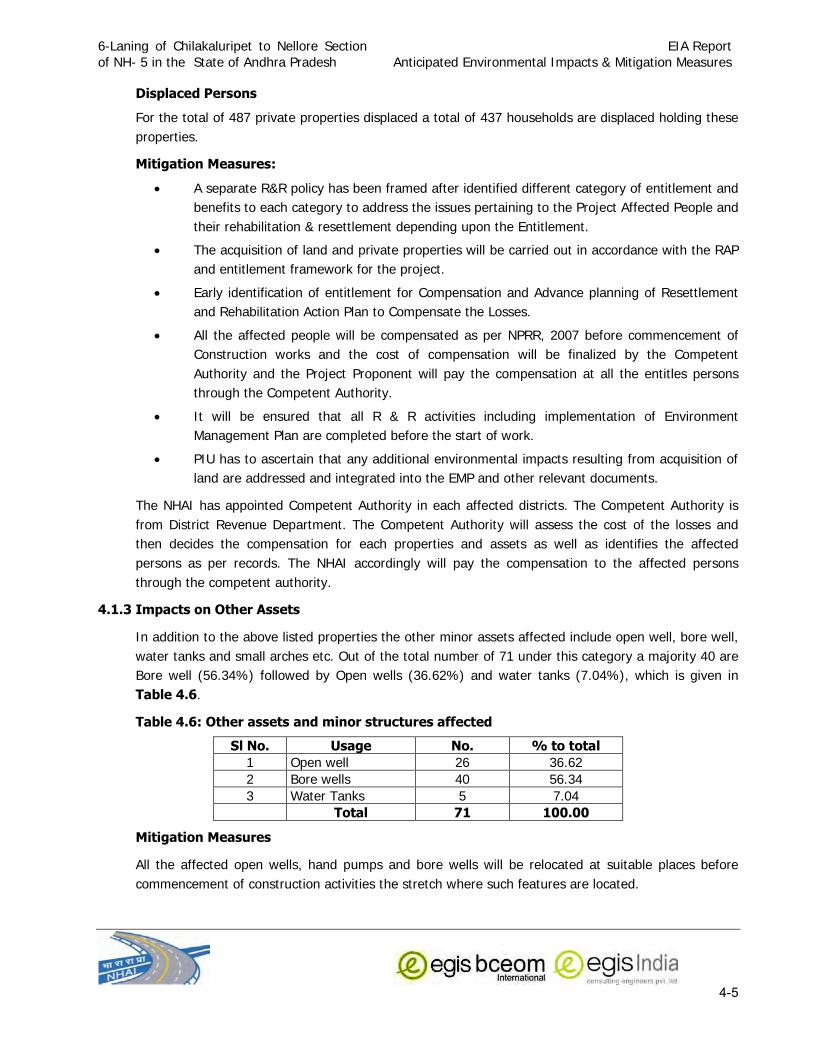
6-Laning of Chilakaluripet to Nellore Section
of NH- 5 in the State of Andhra Pradesh
EIA Report
Anticipated Environmental Impacts & Mitigation Measures
4-5
Displaced Persons
For the total of 487 private properties displaced a total of 437 households are displaced holding these
properties.
Mitigation Measures:
• A separate R&R policy has been framed after identified different category of entitlement and
benefits to each category to address the issues pertaining to the Project Affected People and
their rehabilitation & resettlement depending upon the Entitlement.
• The acquisition of land and private properties will be carried out in accordance with the RAP
and entitlement framework for the project.
• Early identification of entitlement for Compensation and Advance planning of Resettlement
and Rehabilitation Action Plan to Compensate the Losses.
• All the affected people will be compensated as per NPRR, 2007 before commencement of
Construction works and the cost of compensation will be finalized by the Competent
Authority and the Project Proponent will pay the compensation at all the entitles persons
through the Competent Authority.
• It will be ensured that all R & R activities including implementation of Environment
Management Plan are completed before the start of work.
• PIU has to ascertain that any additional environmental impacts resulting from acquisition of
land are addressed and integrated into the EMP and other relevant documents.
The NHAI has appointed Competent Authority in each affected districts. The Competent Authority is
from District Revenue Department. The Competent Authority will assess the cost of the losses and
then decides the compensation for each properties and assets as well as identifies the affected
persons as per records. The NHAI accordingly will pay the compensation to the affected persons
through the competent authority.
4.1.3 Impacts on Other Assets
In addition to the above listed properties the other minor assets affected include open well, bore well,
water tanks and small arches etc. Out of the total number of 71 under this category a majority 40 are
Bore well (56.34%) followed by Open wells (36.62%) and water tanks (7.04%), which is given in
Table 4.6.
Table 4.6: Other assets and minor structures affected
Sl No. Usage No. % to total 1 Open well 26 36.62
2 Bore wells 40 56.34
3 Water Tanks 5 7.04
Total 71 100.00
Mitigation Measures
All the affected open wells, hand pumps and bore wells will be relocated at suitable places before
commencement of construction activities the stretch where such features are located.

6-Laning of Chilakaluripet to Nellore Section
of NH- 5 in the State of Andhra Pradesh
EIA Report
Anticipated Environmental Impacts & Mitigation Measures
4-6
4.1.4 Land use Change
In order to accommodate the proposed alignment some land is to be acquired. The proposed Ongole
bypass further requires land acquisition for the designed highway section. This will cause diversion of
land to highway from current use. Acquisitions of some agricultural or some commercial land will be
needed for widening of the road to meet the design specification. As the land acquisition is very
limited along the entire project stretch beyond the existing ROW the severity of diversion of other land
would not be high. The widening section would involve only small sections of agricultural land and
thus the anticipated loss of productive agricultural land is not significant. 7 ponds/water tanks will be
affected due to the proposed Right of Way. Partial filling of these ponds/ tanks for construction is
unavoidable due to engineering constraints as well as due to minimization of land acquisition and loss
of agricultural lands.
4.1.5 Impact on Water bodies:
Baseline study of the area indicates that the area along the ROW is dotted with a number of water
tanks/ponds. These store rainwater during rainy season and mainly used for irrigation purpose. The
widening will result into partial acquisition of such bodies which are situated adjacent of the ROW.
These water tanks/ ponds are maintained by the Irrigation Department. A list of affected water
tank/ponds and area required to be acquired is presented below:
Table 4.7: List of affected Water Tanks due to Proposed Widening
The impact on such water bodies can be minimize by restricting earth filling only within portion falling
within the formation width. The proper protection measures like provision of bunding, silt traps in
consultation with line department, i.e. Irrigation Department. Oil interceptor may be provided at the
S. No
Name of Tank/Bund Chainage Side
(LHS/RHS)
Length (m)
Acquired Width varies
(m)
Average Aquired width (m)
Total tank Area
required (m2) From to Min Max
1
Valluramma 1253+500 1253+950 RHS 450 10.65 14.58 12.62 5676.75
1254+480 1254+600 RHS 120 7 12 9.50 1140.00
1255+700 1256+350 RHS 650 18.23 20.5 19.37 12587.25
1256+700 1256+800 RHS 100 0 11.75 5.88 587.50
2 Tank with Bund 1292+050 1292+400 RHS 350 13.3 13.3 13.30 4655.00
3
Tank without
Bund 1292+300 1292+600 LHS 300 5.24 10.4 7.82 2346.00
4 Ekurupadu Tank 1306+000 1306+800 RHS & LHS 800 9.37 9.37 9.37 7496.00
5 Jutur Tank 1319+350 1319+920
RHS &
LHS 570 7.41 9.57 8.49 4839.30
6 Tank 1324+250 1324+400 LHS 150 16.34 16.34 16.34 2451.00
7 Gauravaram 1333+900 1334+500 RHS 600 16.82 17.54 17.18 10308.00
8 Kadanutala 1346+150 1346+320 RHS 170 9.72 10.5 10.11 1718.70
9 Tank 1349+450 1349+750 RHS 300 6.5 14.85 10.68 3202.50

6-Laning of Chilakaluripet to Nellore Section
of NH- 5 in the State of Andhra Pradesh
EIA Report
Anticipated Environmental Impacts & Mitigation Measures
4-7
roadside ponds/tanks to avoid contamination of tank/pond due to mixing of runoff water from
highway section during rains.
4.1.6 Religious, Common and Govt. Property Affected
There are 42 number of religious structures are present along the project stretch out of which 30
structures will be required to be relocated and others will be affected partially. The list of religious
structure to be relocated is given in Table 4.8.
Mitigation M easures: Required mitigation measures for land acquisition will be followed for
acquisition. The PIU will ensure that the religious structures are relocated before start of construction
of road and the idols/artifacts are relocated in the new structure before demolishing the structures
falling in Corridor of Impact. The relocation site for all these features will be finalized after discussion
with the user community and accordingly compensatory measures will be taken.
Table 4.8: Religious Structures within the Proposed ROW
Sl No. Type of Structures Chainage Km LHS/ RHS Village/Town
A. Guntur District Total Religious place (Nos.) 0
B. Prakasham 1 Religious place 1194+460 RHS Konanki
2 Religious place 1194+475 RHS Konanki
3 Religious place 1194+480 RHS Konanki
4 Religious place 1194+485 RHS Konanki
5 Religious place 1194+495 RHS Konanki
6 Religious place 1196+010 RHS Konanki
7 Religious place 1200+600 RHS Kondamanjulur
8 Religious place 1202+000 RHS Kondamanjulur
9 Religious place 1211+430 RHS Alavalapadu
10 Religious place 1227+025 RHS Gundlapally
11 Religious place 1231+210 LHS Maddipadu
12 Religious place 1233+920 LHS Seetharam puram
13 Religious place 1233+920 LHS Seetharam puram
14 Religious place 1235+760 LHS Doddavarapu padu
15 Religious place 1243+050 RHS ongole
16 Religious place 1300+300 RHS Mocharla
17 Religious place 1300+740 RHS Tettu
18 Religious place 1301+550 LHS Tettu
19 Religious place 1301+550 LHS Tettu
20 Religious place 1301+550 LHS Tettu
21 Religious place 1301+550 LHS Tettu
Total Religious place (Nos.) 21 C. Nellore
1 Religious place 1311+810 LHS Maddurupadu
2 Religious place 1313+170 RHS Maddurupadu
3 Religious place 1333+510 RHS Kadanauathala
4 Religious place 1333+550 RHS Kadanauathala

6-Laning of Chilakaluripet to Nellore Section
of NH- 5 in the State of Andhra Pradesh
EIA Report
Anticipated Environmental Impacts & Mitigation Measures
4-8
Sl No. Type of Structures Chainage Km LHS/ RHS Village/Town
5 Religious place 1333+550 RHS Kadanauathala
6 Religious place 1334+415 RHS Kovurupalli
7 Religious place 1334+415 RHS Kovurupalli
8 Religious place 1337+550 LHS Tippa
9 Religious place 1350+260 LHS Racharlapadu
Total Religious place (Nos.) 9 Grand Total (Guntur+Prakasam+Nellore Districts) 30
4.1.7 Impact on Utilities
Several types of utilities serving local and regional needs are falling under COI will need to be
relocated from their present position due to the proposed widening alignment. These services are
mainly electric poles, transformers, OFC lines, wells and bore wells and water supply pipelines which
may be required to be relocated at some locations. Such type of impacts due to the widening of
highways is inevitable.
Mitigation Measures: All the utilities will be restored in advance prior to the start of construction
works. The required mitigation measures would be to instruct in advance the relevant owners of these
utilities to shift those before construction starts to avoid disruption of local services. The
Concessionaire will submit the details of such features falling within the alignment and inform the PIU.
It will be judicious for the PIU to assist the owners to get land for new locations.
4.1.8 Impact on Roadside Trees
The present project will have varying levels of impact on the roadside plantations through out the
entire stretch of the road. This impact is viewed critical due to long duration required for its reversal
and sometimes it is irreversible. Roadside plantations not only provide a healthy aesthetics to the road
users but also provide shade and protect the users from harmful effects of contaminants by absorbing
them through vegetation canopy.
A total number of 32506 trees of varying girth are located within the corridor of impact and are likely
to be felled due to the project. Out of these, a total number of 273 trees will required to be cut in the
district Guntur, 25144 from Prakasam District and rest 7089 in Nellore district. The average distance
of the tree rows from the edges of the existing carriageway varied between 5 m to 8 m. Cutting of
roadside tree are inevitable in highway projects. Apart from the widening of the existing carriageway a
number of service roads have also been proposed both the sides of the new carriageway and thus
very limited option is left for saving the existing roadside trees.
The baseline studies showed that there is no any endangered or protected tree species located within
the project area. The predominant tree species to be felled include Gulmohar (Delonix regia), Neem
(Azadirachta indica), Imli (Tamarindus indica), Eucalyptus, Albizzia.lebbeck (Kala Siris) and Acacia
auriculiformis, and rest are having mainly ornamental value. These are all ubiquitous species.

6-Laning of Chilakaluripet to Nellore Section
of NH- 5 in the State of Andhra Pradesh
EIA Report
Anticipated Environmental Impacts & Mitigation Measures
4-9
Mitigation Measures
• Permission of Roadside cutting will be obtained from the line department, i.e. Forest
Department.
• All efforts will be made to preserve trees by restricting tree cutting within the formation width.
Special attention will be given for protecting giant trees, and locally important trees (having
cultural importance)
• Compensatory plantation will be carried out along the space available within the proposed
ROW in the ratio of at least 3 times as much the trees are proposed to cut as per Forest
(Conservation) Act.
• A general guideline for tree plantation will be followed as per IRC:SP: 21:2009 and as per
Tree Plantation Strategy given in Annexure-9.1 of Environmental Management Plan
(Chapter-9).
• Median plantation has also been proposed. These plantation will not only compensate the loss
but at the same time will enhance the aesthetic along the highway and enhance the pollution
alleviation capacity of the area.
• The avenue plantation programme will be promptly adopted to restore and further enrich the
loss of vegetation.
4.1.9 Impact on Reserved Forest Land:
The baseline study showed that reserved forest patches are located along the project stretch. It has
been proposed to accommodate the widening within the available ROW in the stretch where the
Reserved Forests are located in order to avoid acquisition of reserved forest land. Retaining walls will
be provided on eitherside to maintain required formation width for six laning. The forest department
has done eucalyptus plantation in these forest patches. There is no natural habitat of wildlife in
these forest areas. Hence no impact on these forest areas and wildlife is envisaged.
4.2 IMPACTS DURING CONSTRUCTION PHASE
The construction phase, in general, has adverse influence on all the components of environment.
Most of these impacts are primarily due to negligent practices but are short lived and reversible in
nature. A proper care is essential to minimize the adverse impacts to the possible extent to facilitate
the restoration of the environment and can be discussed under following sub-heads.
The standard road construction works involve are site clearance, excavation, filling of earth
materials and sub grade materials, laying of bituminous mixtures, handling of hazardous materials
like bitumen, diesel, etc, dumping of unusable debris materials, transportation of materials from
production site to construction site, and other constructional activities and associated works like
mobilization of constructional equipments, setting up of different construction plants, setting up of
workforce camps, quarrying, transportation of materials, material storage etc. These activities have
certain impacts of various magnitude on different components of environment. The anticipated
impacts due to all these activities have been described below.
6-Laning of Chilakaluripet to Nellore Section
of NH- 5 in the State of Andhra Pradesh
EIA Report
Anticipated Environmental Impacts & Mitigation Measures
4-10
4.2.1 Impact on Land Resources
Clearing and grubbing and excavation of the land within the extent of formation width of the
proposed alignment as well as the proposed bypass are the primary activity to prepare the bed for
road construction The excavation activity will lead into generation of excavated materials which
would mainly soil mixed with pebbles and rocks in the project area. Most of these materials will be
re-used as fill materials, aggregates and for construction of retaining walls. However, still about 20
percent of the excavated material will need to be disposed off due to non-suitability for use in road
fill materials. The disposal of debris materials in haphazard manner will not only hamper the
aesthetic look of the area but at the same time they are potential contaminant for the surrounding
land.
Some land would be needed to establish site offices and construction camps, worker/labour camps.
These will require land acquisition although for a short period.
Substantial amount of land would also be required for extraction of borrow materials. A total
quantity requirement of soil is 28,27,784 cum sand is 2,62,852 cum and 37,85,000 cum
aggregates including Ongole bypasse. For fulfilling of requirement of soil and aggregates certain
land acquisition will be required followed by excavation of materials from that land area. Such type
of activity can lead into disfiguration of topography of the area to minor extent. Water stagnation in
the borrow pit provides ideal breeding sites for mosquitoes and thereby can spread malaria and
dengue if borrow pit is not properly managed . Pits near settlements can pose health risk.
Further haphazard cutting near water courses will result into soil erosion and siltation to the nearby
water bodies.
Mitigation Measures:
• The Construction camps will be located preferably on barren land and sufficiently away from
settlements and water bodies.
• The Construction camp will be provided with necessary sanitation arrangements and basic
facilities.
• After dismantling of Camp the natural condition of the land will be restored.
• No scare will be left unattended after excavation activity.
• The Borrow area will be located preferably on barren land or unirrigated land.
• The Borrow pits will not be dug within 800 m of town or village settlement or within ROW
• After excavation is over, the borrow area will be suitable rehabilitated either by backfilling it of
by dressing the sides of the borrow pit to create slope consistent to the adjoining land.
• Where pit can be developed as water recharging pond depending upon the terrain of the area
• Proper reclamation of pits will be done
• Cut face of the pit will be merged with the slope of the adjoining terrain
• Bottom of the pits will be graded towards natural outfalls to prevent water accumulation
• The reclaimed area will be seeded to provide grass coverage.
• Quarrying of metal will be done only at licensed quarry and the area will be suitable
rehabilitated after quarrying is over.

6-Laning of Chilakaluripet to Nellore Section
of NH- 5 in the State of Andhra Pradesh
EIA Report
Anticipated Environmental Impacts & Mitigation Measures
4-11
• The borrow areas and stone quarry site can be operated and managed as per guidelines
provided in Annexure 9.2 & Annexure 9.3 of Environmental Management Plan (Chapter-9),
respectively.
4.2.2 Impact on Soil
The site clearance process includes excavation and vegetation clearance which ultimately induces
vegetation loss as well as loss of top soil. Since vegetation clearance shall be confined to the
minimum area required for widening activities beyond the ROW the area affected would be very
less. The activities associated with the site preparation and excavation plus movement of vehicles
and equipments can disturb the surrounding lands.
4.2.2.1 Contamination of Soil
Contamination of soil during construction stage is primarily due to construction and allied activities.
The sites where construction vehicles are parked and serviced are likely to be contaminated because
of leakage or spillage of fuel and lubricants. Pollution of soil can also occur in hot-mix plants from
leakage or spillage of asphalt or bitumen. Refuse and solid waste from labour camps can also
contaminate the soil. Contamination of soil during construction might be a major long-term residual
negative impact. Unwarranted disposal of construction spoil and debris will add to soil
contamination. This contamination is likely to be carried over to water bodies in case of dumping
being done near water body locations. However, by following mitigative measures such as
maintenance of vehicles and machines and fuel refilling is carried out in a confined area can avoid
contamination of soil to a great extend. The provision for oil interception chamber is suggested in
EMP for treating the waste water generated from vehicle washing, refilling and maintenance areas.
Fuel storage and refilling sites should be kept away from cross drainage structures and important
water bodies. All spoils shall be disposed off as desired and the site shall be fully cleaned before
handing over. These measures are expected to minimise the impact on soil contamination.
4.2.2.2 Compaction of Soil
Compaction of soil may anticipated due to the movement of construction vehicles and heavy
machines. Thus regulation of movement of heavy equipments and vehicles shall be essential to
prevent this.
Mitigation Measure:
• The excavation activities and vegetation clearance will strictly be limited to formation width
only.
• All the usable excavated materials will be re-used as fill materials and aggregates.
• Fill materials for the embankments are to be arranged from places located outside ROW.
• The movement of construction vehicles and equipments will be restricted to only designated
route.
• Designated storage site for fill materials and adequate stockpiling to prevent erosion and runoff
related problem.
• Construction of temporary berms, sediment basins, slope drains and use of temporary mulches
fabrics or other control measures necessary to control soil erosion and sedimentation will be
done at site.

6-Laning of Chilakaluripet to Nellore Section
of NH- 5 in the State of Andhra Pradesh
EIA Report
Anticipated Environmental Impacts & Mitigation Measures
4-12
4.2.3 Impact on Water Resources
4.2.3.1 Contamination of Surface Water from Construction and Allied Activities:
Activities near the water body may result into contamination of water if proper care is not take. The
waste water from construction sites, campsites, vehicles/equipments servicing centres, stockyards
may carry different types of contaminants and may get way into nearby waterbodies thereby
contaminating water. Staking of construction materials like earth, stones, cement, etc or spoils near
water bodies or along waterways may result into siltation proble of the water ponds/water tank.
Such impacts however can be minimized through proper site management and work plan. Following
mitigation measures will minimize the impacts on impact on surface waterwater bodies:
Mitigation Measures
• All necessary precautions will be taken to construct temporary or permanent devices to prevent
water pollution due to increased siltation and turbidity.
• The precautionary measures to prevent the wastewater generated during construction from
entering into canals, water bodies or the irrigation system and avoid construction works close to
canals or water bodies during monsoon.
• All wastes arising from the project will be disposed off, as per SPCB norms, so as not to block
the flow of water.
• No construction materials/ spoils will be stored along the water bodies and adequate provision
will be made for preventing spillage of materials into these water bodies.
• Wastes must be collected, stored and taken to approved disposal site.
• Water quality to be monitored periodically.
4.2.3.2 Impact on Ground water :
The proposed widening will result in increase of surface run-off. It will have adverse impact on
ground water recharging if measures are not taken during the design and construction of
longitudinal drainages.
The geological studies of the project area show water table 6-20 m below the surface. As the depth
of the ground water table is very high no adverse impact is anticipated on ground water. Laying of
pavement within the formation width may lead to reduction in the ground water recharge capacity.
But as the area involved in the road construction is very less, the chances of this influence will be
non-significant.
Mitigation Measures
• Longitudinal drains of sufficient capacity will be provided on both sides of the road to
accommodate increased run-off.
• In urban stretches, the lined drains will be provided with cut in between to facilitate ground
water recharging. The cut will be made of granular coarse material, which will increase the
infiltration rate.

6-Laning of Chilakaluripet to Nellore Section
of NH- 5 in the State of Andhra Pradesh
EIA Report
Anticipated Environmental Impacts & Mitigation Measures
4-13
• In rural stretches the unlined drains will be connected with ponds. New small ponds will be dug
if necessary. It will help in rainwater harvesting.
• Rainwater Harvesting pits will be provided in consultation with Ground Water Boards at an
average interval of 500 m covering the entire project stretch including Ongole Bypass
depending upon the water table status (The recharge pit can only be provided at those
locations where the water table is greater than 5 m deep). The schematic plan of rainwater
harvesting is presented in Annexure 9.4 of Environmental Management Plan (Chapter-9). The
Concessionaire will have to collect the information about the water table and then construct the
rainwater harvesting pits which will be approved by the Engineer and PIU-NHAI. The
Concessionaire will submit completion after construction of rainwater harvesting pits along with
their details duly certified by the Engineer and PIU-NHAI.
4.2.3.3 Water Requirement for Construction:
As per assessment water requirement for construction and other purposes during peak period would
be about 853 cum/day.
4.10: Water Requirement for Construction
S. No Purpose Water requirement (cum/day)
1 Road making 352
2 Bridge/Curing 132
2 Plant sites/ Dust Suppression 254
3 Drinking 5
4 Domestic & Other uses at Camp sites/laboratory/construction sites/ labour camps
etc.
110
TOTAL 853
The water demands for the construction work may pose severe stress on the public water supply if
the water for construction and allied activities are taken from the same source as the project area is
a water stressed area and water supply sources are limited.
The main source of water for construction and other related activities will be a mixture of surface
water source and ground water source. Most of the rivers and water tanks along the project corridor
are rainfed and contain water for a brief period. Surface water may be used to meet the water
requirement for the project. However groundwater may be used by installing borewells at different
locations such at camp sites and plant sites. separate water supply arrangement for construction
and allied works will be made in from ground water/surface water source away from public water
supply source so that there is no interfere with the normal public water supply. The water for the
construction will be taken after taking prior permission from Competent Authority and comply with
all the requirements of State Ground Water Authority/ Irrigation Department. The Concessionair will
take all the measures in order to minimize wastage of water during the construction.

6-Laning of Chilakaluripet to Nellore Section
of NH- 5 in the State of Andhra Pradesh
EIA Report
Anticipated Environmental Impacts & Mitigation Measures
4-14
The Source of water for construction shall be identified by the Concessionaire depending upon the
location of construction sites, construction camp and plant site locations in consultation with line
department and NHAI and will obtain all necessary statutory permits for usage of water before start
of abstraction of water.
4.2.4 Impact on Water Quality:
No permanent impact is anticipated on water quality due to the project. Construction activity may
temporarily deteriorate surface water quality near the alignment through increase in turbidity as well
as in oil and grease. These impacts are temporary in nature and will be handled through the
proposed mitigation measures:
• All water and liquid wastes arising from construction activities will be properly disposed off
and will not be discharged into any water body without adequate treatment.
• Littering or unauthorized discharge will not be permitted.
• Permission of the engineer and the concern regulatory authorities will be obtained for
disposal of the waste as the designated disposal point.
• The stream course and drain will be kept free from dumping of solid wastes and earth
materials.
• The construction materials and debris will be stored away from water bodies or water ways
and only on the designated sites along the construction zones.
4.2.5 Impact on Ambient Air Quality
The air quality parameter is the most common environmental feature, which is being affected by any
road improvement projects at different stages i.e. during constructional as well as operational
phase. The major indicators of Ambient Air Quality relevant to the road project are the concentration
of suspended particulate matters (SPM), Particulate matters of size less than 10 µ (PM10), particulate
matters of size less than 2.5µ (PM2.5), sulphur dioxide (SO2), nitrogen oxides (NOx), carbon
monoxide (CO) in the atmosphere. The majority of the air pollutants are emitted from the traffic as
there is no major activity along the project road except for few small scale industries. The result of
the measurement of these parameters in the atmosphere along the project road showed that the
concentration of these air pollutants are well below the safe limit as prescribed for the National
Ambient Air Quality laid by Ministry of Environment and Forests, Government of India at all the
places.
Significant amount of dust would be generated due to site clearance and excavation activities,
exhaust of mobile and stationary construction equipment, stone crushing plant, batching plant, HMP,
demolition, embankment and grading activities, transportation of earth materials and dumping of
spoils, which have potential deterioration of air quality during the process. This can increase the
localized concentration of fugitive dust during construction phase. During asphalt preparation,
operation of hot mixing plants needs burning of fuels that result into release of significant amount of
gaseous pollutants into the atmosphere like oxides of sulfur, hydrocarbons and particulate matters.
These are likely to deteriorate the air quality in general and also cause occupational exposure in
particular. These impacts are, however, temporary one that will remain only upto the period of
clearance and excavation processes. Besides this, air quality deterioration is also expected at

6-Laning of Chilakaluripet to Nellore Section
of NH- 5 in the State of Andhra Pradesh
EIA Report
Anticipated Environmental Impacts & Mitigation Measures
4-15
deposits and borrows sites, materials treatment areas, quarries, access roads and the site where
facilities provided for project workers due to dust generation and gaseous pollutant emission.
Additional vehicular emission is expected during the mobilization of construction equipments,
transportation of materials, etc. due to the increased vehicular number at the project sites but that
will be minor in extent as there will not be significant increase in vehicle numbers.
The improper sanitation at work camps and waste disposal usually lead to odour problem. Foul
odour may also caused during laying of pavement. The abovementioned problems related to the
deterioration of air quality, however, will temporal in nature till the construction period only. Further,
the activities will not be confined to any one place rather, it will progressively move along the ROW,
so prolonged deterioration in air quality will not occur at any one site. The minor volume of dust
generated will cause a short-term localized problem through settlements.
Mitigation measures:
Generation of Dust
• Water will be sprayed during construction phase, in earth handling sites, asphalt mixing
sites and other excavation areas for suppressing fugitive dust.
• Water sprinkling and transporting construction materials with tarpaulin coverage duringthe
construction stage.
• During the sub-grade construction, sprinkling of water will be carried out on regular basis
during the entire construction period especially in the winter and summer seasons.
• In case fly ash is used, dust emission during its loading and unloading, storage at open
place and handling for road construction shall be suppressed by regular water sprinkling.
• Dust emission from stock piles of excavated material will be controlled either by covering
the stockpiled materials or water spraying over it.
• Special attention will be given when working near educational institutions and health centers
and settlement areas.
• As soon as construction is over all the surplus earth will be utilized properly all loose
earth will be removed from the site.
M itigation measures for P lants & Equipments:
• The Stone crusher plant, Hot mix plant and Wet Mix Plant will be located sufficiently away
from settlement towards downwind direction and will conform to the siting and operation
requirements under Environmental (Protection) Rules, 1986.
• Proper management of all Plant sites having stone crusher unit, Hotmixplants, Batchmix
plant, stockyards.
• All the vehicles used during the construction stage to have valid PUC certificate
• Provision of effective air pollution control systems in stone crushers, Hotmix Plant, Batchmix
plants such as Dust containment cum suppression system for the equipment, Construction
of wind breaking walls along periphery of plant sites, construction of the metalled roads
within the premises, regular cleaning and wetting of the ground within the premises, etc.

6-Laning of Chilakaluripet to Nellore Section
of NH- 5 in the State of Andhra Pradesh
EIA Report
Anticipated Environmental Impacts & Mitigation Measures
4-16
Gaseous Pollution
• All the Construction vehicles and machineries will be regularly maintained to conform to the
emission standards stipulated under Environment (Protection) Rules, 1986.
• Asphalt mixing /Stone Crusher plans should be located at list 800 m away from any
habitation or sensitive environmental site and at least 250 m away from highway towards
downwind direction.
• All the DG sets will conform to the emission standards as stipulated under Environment
(Protection) Rules, 1986.
• The workers working at asphalt mixing and subsequent application of asphalt mix on road
surface will be provided with heat resistant shoes and masks.
4.2.6 Impacts on Noise Level
Operation of heavy machineries; movement of heavy vehicles, stone crushing aggregate mixing
activities generates high noise increasing the ambient noise level in the surrounding. The behavior
of truck drivers also plays roles in increasing the noise level by the injudicious frequent use of blow
horns. Especially in the settlement area this can pose a problem.
Workers working near the noise generating equipments and plants are likely to be exposed to high
noise level. The acceptable limits (for 8 hour duration) of the equivalent noise level exposure during
one shift is 90 dB(A). Hence, noise generated due to various activities in the construction camps
may affect health of the workers if they are continuously exposed to high noise level. For reasons of
occupational safety, exposure to impulses or impact noise should not exceed 140 dB (A) (peak
acoustic pressure). Exposure to 10,000 impulses of 120 dB (A) are permissible in one day. The noise
likely to be generated during excavation, loading and transportation of material will be in the range
of 90 to 105 dB (A) and this will occur only when all the equipment operate together and
simultaneously. This is however, is a remote possibility. The workers in general are likely to be
exposed to an equivalent noise level of 80 to 90 dB (A) in an 8-hour shift, for which all statutory
precautions should be taken into consideration. However, careful planning of machinery selection,
operations and scheduling of operations can reduce these levels. A typical Noise generation due to
different activities has been given in the Table 4.11.
Table 4.11: T ypical N oise L evels of P rincipal C onstruction E quipment during ma jor construction activity (Noise Level in dB (A) at 50 Feet)
Activities and Equipment Noise Levels in dB(A) CLEARING Bulldozer Front end loader
Dump truck Jack hammer
Crane with ball
80 72 - 84
83 - 94 81 - 98
75 - 87
EXCAVATION AND EARTH MOVING Bulldozer Backhoe
Front end loader Dump truck
Jack hammer Scraper
80 72 - 93
72 - 84 83 - 94
81 - 98 80 - 93
6-Laning of Chilakaluripet to Nellore Section
of NH- 5 in the State of Andhra Pradesh
EIA Report
Anticipated Environmental Impacts & Mitigation Measures
4-17
STRUCTURE CONSTRUCTION Crane
Welding generator Concrete mixer
Concrete pump
Concrete vibrator Air compressor
Pneumatic tools Bulldozer
Cement and dump trucks Front end loader
Dump truck
Paver
75 - 77
71 - 82 74 - 88
81 - 84
76 74 - 87
81 - 98 80
83 - 94 72 - 84
83 - 94
86 - 88
GRAND AND COMPACTING Grader
Roller
80 -93
73 - 75
PAVING Paver
Truck Tamper
86 - 88
83 - 94 74 - 77
LANDSCAPING AND CLEAN UP Bulldozer Backhoe
Truck
Front end Loader Dump Truck
Paver
80 72 - 93
83 - 94
72 - 84 83 - 94
86 - 88
Source: CPCB, Govt. of India
It is evident from the above table that the operation of construction machinery e.g. hot-mixer,
bulldozer, loader, backhoes, concrete mixer, etc will lead to rise in noise level to the range between
80-95 dB (A). Vehicles carrying construction materials will also act as the noise sources. The
magnitude of impact from noise will depend upon types of equipment to be used, construction
methods and also on work scheduling. However, the noise pollution generated due to different
construction activities is a temporary affair. Each type of activity can generate different type and
levels of noise that continue for a short period during the operations of those activities.
Implementing proper mitigation measures can reduce a lot of problem associated with noise
pollution due to construction activities.
Mitigation Measures:
• All noise generating equipments will be installed sufficiently away from settlement areas.
• Provision for stationary machines and equipment with acoustic enclosures and silencers,
• Provision of mandatory acoustic enclosure /acoustic treatment of room for stationary DG
sets (5KVA and above). The acoustic enclosure/acoustic treatment of the room should be
designed for minimum 25 dB (A) insertion loss for meeting the ambient noise standards,
whichever is on the higher side. The DG set should be provided with proper exhaust muffler
with insertion loss of minimum 25 dB (A)
6-Laning of Chilakaluripet to Nellore Section
of NH- 5 in the State of Andhra Pradesh
EIA Report
Anticipated Environmental Impacts & Mitigation Measures
4-18
• The plants and equipment used for construction will strictly conform to CPCB noise
standards.
• Vehicles and equipments used will be fitted with silencer and maintained accordingly.
• Noise to be monitored as per monitoring plan and if the noise level at any time found to be
higher than immediate measure to reduce noise in that area will be ensured.
• Noise standards of industrial enterprises will be strictly enforced to protect construction
workers from severe noise impacts. All the workers working very close to the noise
generating machinery shall be provided Earplugs to avoid any ill impacts on their health.
• An awareness programme will be organized for drivers and equipment operators to make
them aware of the consequences of noise and to act properly at site.
4.2.7 Impact on Ecological Resources
The baseline study of the biological environmental within the project area did not show any
endangered or significant flora or fauna and within the corridor of impact and there is no wildlife
migration route reported, therefore, any potential direct impact on biological environmental
characteristics such as, loss of rare or endangered species, habitat fragmentation and wild life
migrations is not envisaged. The area is not characterized by any significant ecosystem so loss of
habitat is not there. Moreover, the alignment of proposed road widening is mostly along the existing
road, the potential for habitat fragmentation negligible. Similarly, since the road improvement is
proposed for the already existing one the extent of impact is minimum. The temporary impact may
be in the visual appearance of the trees and shrubs as construction activity may lead to deposition
of dust cover over the leaves and foliage. This is limited to construction period and gets washed
away with the first monsoon shower.
There is no any National Park, Wild Life Sanctuary, Tiger Reserves or Ecological Sensitive area or
any other features located within 15 Km radius of the project hence no impact on such features
anticipated due to the project.
4.2.8 Impact on Social Environment
4.2.8.1 Impairment of access to the properties
During construction of road, cross water and side drain temporary blockage of access or interference
with the access to the properties located along the right of way may occur, causing inconvenience to
the road users and enhances the accident risk if not managed properly. Such impact can be avoided
through proper planning of works and good engineering practices. Safe and convenient passage for
vehicles, pedestrians and livestock to and from roadsides and property accesses connecting the
project road shall be ensured by providing temporary access. Adequate signage and barricades shall
be raised at the expected bottlenecks for safe movement of people. The Concessionaire shall
provide early information to the affected people. On completion of the works, all-temporary
obstructions to access shall be cleared away, all rubbish and piles of debris that obstruct access
should be cleared.
4.2.8.2 Aesthetics
Disturbance of landscape aesthetics due to excavation of borrow pits, extensive quarrying, disposal
site of spoils, is expected during the constructional phase. However, it is only temporary one and it
6-Laning of Chilakaluripet to Nellore Section
of NH- 5 in the State of Andhra Pradesh
EIA Report
Anticipated Environmental Impacts & Mitigation Measures
4-19
can be restored with proper management plans within a short period such as roadside plantation,
etc. During operational phase this will be enhanced with the activities associated with the
maintenance of landscape such as plantation programme, by providing road side amenities, parks
etc.
Mitigation Measures:
• The site will be cleaned immediately after the construction activity is over.
• The debris materials will be disposed off only at identified area for disposal and proper
leveling will be done after disposing the materials and shall be covered with top soil and
some plantation will be done at the disposal site
• The borrow area will be rehabilitated as per site condition. It can either be developed as
ponds, backfilled and leveled machine with the surrounding terrain.
4.2.8.3 Public Health and Safety
Health and safety are of major concern during the construction as well as operational phases. The
impact on health and safety can be envisaged for both workers at site and road users as well as
inhabitants of nearby areas.
Emission of gaseous pollutants and dusts are major result of various processes like material
treatment, operation of hot mix plant, stone crushing, and asphalt preparation. This emission effect
is only for short term till the construction work is over but the effect may be significant from the
point of view that the workers are directly exposed to these emissions. Apart from this, safety risks
to road workers, primarily in the areas of storage and handling of dangerous materials, and in
operation of heavy machinery close to traffic, slopes, power line and water courses, are also
involved during the construction works.
The dust and gaseous pollutant generation within the congested area during the construction works
will adversely affect the health of people residing in the close proximity of the road. Excavation of
borrow pits on both the sides of roads within and outside the existing ROW can create unhealthy
aesthetics and also enhance the risk of malaria. These areas provide ideal breeding zones for flies
and insects. Stagnancy of water in borrow pits located nearby settlements during rains may enhance
the possibility of spreading of diseases. The vehicles and equipment operation increase the chances
of collision with vehicles, pedestrians and livestock. The poor sanitation and poorly manages dispose
off the waste may cause increase in communicable diseases.
Mitigation Measures:
• The plants and equipments will be installed sufficiently away from the settlement.
• All the construction equipments and vehicles will conform with the emission standards
stipulated by the CPCB.
• Safe working techniques will be followed up and all the workers will be trained
• All the workers will be provided with proper personal safety equipments at construction as
well as plant site
• Proper caution signage, barricading, delineators etc. will be installed at Construction zone
and temporary diversions

6-Laning of Chilakaluripet to Nellore Section
of NH- 5 in the State of Andhra Pradesh
EIA Report
Anticipated Environmental Impacts & Mitigation Measures
4-20
• Proper traffic management will be ensured at the Construction zone as per IRC.
• An Emergency Response system in case of any incidence will be developed and
implemented
• Periodical health check facility will be provided at camp sites.
4.2.9 Other Environmental Concerns of Construction Phase:
Various other environmental impacts during construction stage include:
4.2.9.1 Diversion of Traffic
Short term impact associated with the project will be traffic diversion and management during
construction phase. Construction activities will cause hindrance to the existing traffic flow. There is
possibility of accident hazards during construction phase of the widening project there will be
requirement for diversion of existing traffic at various construction sites during construction phase.
It needs to be mentioned that though there are no direct impacts on the natural environment due to
disruption/diversion of such services, but diversion can also lead to adverse impacts if not planned
properly. Rapid restoration of diverted services can help in minimizing the severity of impacts arising
out due to diversions of existing services.
Mitigation Measures:
• Proper preventive measures will be taken during the construction activities at the
construction sites
• Reduce speed through construction zones.
• Construction of bridges/culverts will be carried out prior to construction of new carriageway
at the first stage.
• Strengthening/raising of existing two lanes will be done only after the completion of the first
stage.
• Proper warning signs will be displayed at construction sites.
4.2.9.2 Equipment Servicing and Fuelling
On large road projects, thousands of liters of diesel and many other petroleum products are
transported and used throughout the work site every day. Construction equipment generates large
amount of waste oil, and its proper handling is critical, since improper storage and leakage can
result in the contamination of land and water bodies. Even the spillage can affect surface water
bodies by the road sector project.
Mitigation Measures:
• The vehicle and equipment service centers will be established away from any water body or
agricultural land.
• Proper bunding with appropriate Containment will be provided at the equipment and vehicle
servicing centers. The spent wash from the service center will be put in separate soak pits
and sand pits
• All the fuel and chemical storage will be sited on an impervious base within an embankment
and secured by fencing. The storage area will be located away from water course or
wetland.

6-Laning of Chilakaluripet to Nellore Section
of NH- 5 in the State of Andhra Pradesh
EIA Report
Anticipated Environmental Impacts & Mitigation Measures
4-21
4.2.9.3 Construction Camps
Workers’ Camp
Construction workers are a very neglected group in the country. Unless the workers are provided
proper amenities to live at the construction site the environmental issues of road construction
cannot be properly met. Apart from labour camps, separate construction Camps also established
where various plants and equipments as well as offices and residential units for technical and non
technical staff are located and often labour camps are also provided in the same premises. Location
of the Construction camp also has certain impacts on surrounding environment if not properly
managed.
At labour and construction camps lot of wastes are generated. These wastes are refuge from the
plants, and equipments, waste water and other domestic waste. These wastes are solid as well as
liquid waste mainly refuse water and kitchen waste. The disposal of such waste material to the
surrounding land can potentially damage the land and would generate health risk to not only
surrounding area but within the premises itself. Improper drainages system within the premises also
creates insanitation condition thereby enhancing health risk.
Mitigation Measures:
• The Construction/labour camps will be established only on area approved by NHAI.
• The worker’s/labour camp will be located away from water bodies, schools and residential
areas. The camp will be constructed with proper accommodation facilities.
• The workers camp will be provided with drinking water supply system so that local water
sources are not disturbed.
• The camp should be provided with fuel for cooking like kerosene and /or LPG to avoid any
cutting of trees for fuel wood.
• All camps will be provided with proper sanitation facilities, separate toilets and bathrooms
for female and male workers, septic tanks with soak pits of sufficient size, dust bins etc.
• Waste water from domestic uses and solid wastes will be disposed of without violating
environmental norms. The measures will be site specific.
• The labour camps will be provided with crèche, first aid facilities, etc as required under
Factory Act.
• After completion of construction, the contractor will dismantle the camp and restore it to the
original condition of the area before handing over the site to the land owner.
4.2.9.4 Disruption of Services
Local services, including water supply lines, irrigation line, drainage, ditches, streets are commonly
cut during road earthworks. These activities are required by the local people for crop production, drinking water supply and access, and have the potential to damage road work too. These services
are often either inadequately reconnected or not reins ted at all.
Mitigation Measures:
• The Contractor will arrange their own source to cater for their water requirement for
construction and other activities and will not interfere with the local water supply system

6-Laning of Chilakaluripet to Nellore Section
of NH- 5 in the State of Andhra Pradesh
EIA Report
Anticipated Environmental Impacts & Mitigation Measures
4-22
• All irrigation canals, water supply lines and stand pipes, drainage and streets will be
maintained during construction or if necessary, temporary services shall be arranged of the
owner/ user’s permission for temporary cessation will be gained.
• All the Services will be progressively reinstalled as soon as road excavation has been
completed.
4.3 IMPACTS DURING OPERATIONAL PHASE
During operation stage, the main sources of environmental impacts are the increased traffic volume
and speeds and better access to forest lands. The increase in traffic volume and speed may enhance
the safety risk especially in the rural area. The better access to the forest area can stimulate the
human interference in these areas. No sudden change in the traffic volume is expected due to this
road as the road is already existing one and opened for public traffic. The project also provides the
opportunities of the restoration of vegetation around the vicinity of the worksite and roads by
implementing the compensatory plantation programme, which will not only enhance the aesthetic
view but can also help in reclamation of soil. During operational phase this will be enhanced with the
activities associated with the maintenance of landscape such as plantation programme, by providing
roadside amenities, parks etc.
During the operational phase when the plantation works will be adequately implemented will
enhance the aesthetic as well as hygienic environment thereby reducing the chances of diseases due
to vehicular emission. Widening will ensure smooth plying of the vehicles and also will help in
reducing the congested zone and thus will reduce the emission rate of vehicles. Various impacts
during operation phase are discussed below:
4.3.1 Impacts on Water Quality and Resources
During the operation phase, the possibility of degradation of water quality is very remote. The
impact on the surface water quality during operation can be expected due to accidental spillage.
However the probability of such accidents are minimal since enhancement of road safety measures
such as improvement of curves and widening of the roads and other pedestrian facilities are taken
care of in the design stage.
4.3.2 Impact on Air Quality
The baseline data shows that all pollutants are well within permissible limit at all monitoring
locations. The net air quality impact following construction of new road is anticipated to be
beneficial. Improvement in road surface condition such as roughness, pot, patch, congestion, etc.,
improvement of curves and junctions will ensure the smooth traffic flow and reduce idling time of
engines thus reduce the emission rate of vehicles and also the vehicle maintenance cost thereby
reducing the magnitude of air quality degradation. Further, roadside avenue plantation with
pollution abating tree species will also help in reducing the ambient pollution levels. Moreover,
widened road will provide more space for dispersion and thereby the concentration of pollutants will
be diluted faster. The project will not stimulate the traffic flow significantly as this road is already in
use. The traffic will however rise with the current growth rate and the number of vehicles plying
over will certainly be increases whether the project will come or not. Although the emission rate per
vehicle will reduce as stated earlier, but the total emission can increase in future with the increase in
traffic.

6-Laning of Chilakaluripet to Nellore Section
of NH- 5 in the State of Andhra Pradesh
EIA Report
Anticipated Environmental Impacts & Mitigation Measures
4-23
Prediction of Carbon Monoxide (CO) Concentration along the Project Highway
Carbon monoxide (CO) is an odorless, colorless, poisonous gas whose primary source is motor
vehicle emissions. Carbon Monoxide is chemically inert under normal conditions and has an
estimated atmospheric mean life of about two and half months. CO is emitted by incomplete burning
of fossil fuel. Concentrations of this gas are highest near the road. Because meteorological
conditions are a significant factor affecting the development of high levels of CO, CO is primarily a
winter period pollution problem, when periods of light winds or calm conditions combine with the
formation of ground level temperature inversions; typically from the evening through the early
morning period. The National Ambient Air Quality Standard (CPCB) prescribes standard limit for CO
in the ambient air as 2 mg/m3 and 4 mg/m3 on 8-hr and 1-hr average respectively. At higher
concentrations, i.e., above 5 mg/m3 it can seriously affect human aerobic metabolism, owing to its
high affinity for haemoglobin and thus would affect the central nervous system, impairing a person’s
time-interval discrimination and brightness discrimination and over 10 mg/m3, concentration would
result in cardiac, pulmonary functional changes / failure leading to death.
As CO is produced in greatest quantities from vehicle combustion and does not readily disperse into
the atmosphere in comparison, hence, CO is considered as critical pollutant.
For the purpose of future prediction of CO concentration in the ambient air along the project road,
the roads were divided into four homogenous section based on traffic volume and environmental
monitoring location setup. These homogeneous sections are (i) Chilakaluripet-Medarametla (ii)
Medarametla-Ongole (iii) Ongole-Kavali and (iv)Kavali-Nellore.
The prediction of CO concentration has been made for 2011, 2015, 2020, 2025 and 2030 AD by
using CALINE 4 dispersion model as recommended by MoEF. CALINE4 is the last in a series of line
source air quality models developed by the California Department of Transportation (Caltrans). It is
based on the Gaussian diffusion equation and employs a mixing zone concept to characterize
pollutant dispersion over the roadway. The purpose of the model is to assess air quality impacts
near transportation facilities. Given source strength, meteorology and site geometry, CALINE4 can
predict pollutant concentrations for receptors located within 500 meters of the roadway. It also has
special options for modeling air quality near intersections, street canyons and parking facilities.
Aerodynamic roughness coefficient of the traffic homogeneous sections and their existing &
proposed width in along which air quality impact assessment is carried out and the emission
standards for different category of vehicle employed for the impact analysis is provided in the Table 4.12. The line source model CALINE4 is executed under the worst-case wind angle with other
meteorological parameters for the conservative impact assessment as provided in the Table 4.13.
Table 4.12: Land use, Emission Standards and the Road Width Traffic Homogeneous Section
Chainage (km) Land use Emission S tandards (gm/km)*
Road Width (m)
From To Light-duty Vehicles
Heavy-duty Vehicles
2011 2015-2030
Chilakaluripet-
Medarametla
1182+802 1218+123 Suburban 3.90
3.78 20 28

6-Laning of Chilakaluripet to Nellore Section
of NH- 5 in the State of Andhra Pradesh
EIA Report
Anticipated Environmental Impacts & Mitigation Measures
4-24
Medarametla-
Ongole
1218+123 1244+735 Suburban 3.90 3.78 20 28
Ongole-Kavali
1244+735 1319+100 Suburban 3.90 3.78 20 28
Kavali-Nellore
1319+100 1366+547 Suburban 3.90 3.78 20 28
*Source: National Auto Policy (2003)
Aerodynamic Roughness Coefficient (cm)
Wind Speed (m/s)
Wind direction Std. Dev (degree)
Ambient Temperature (0C)
Atmospheric Stability Class
Altitude above sea level (m)
Mixing Height (m)
100 1.5 5 20.5 7 16 50
Results and Inferences:
The model was run on a worst-case meteorology condition and used the worst-case wind direction
mode to obtain the highest concentration at each receptor. CO concentrations were estimated for
seven receptor locations. Each receptor was placed about 25 meter from the edge of the road. The
meteorological conditions represent worst-case conditions when CO concentrations are typically
highest, in this case a calm winter period. An ambient temperature of 25.5 degrees Celsius was also
assumed. The meteorological inputs include: 1.5 meter per second wind speed, ground-level
temperature inversion (atmospheric stability class G), wind direction standard deviation equal to five
degrees, and a mixing height of 50 meter.
CALINE4 dispersion model was executed by using data on link geometry, traffic volume and
environmental receptors location. The output CO results at specified locations along the project road
for projected years 2011, 2015, 2020, 2025 and 2030 AD respectively are presented in Table 2.3. Based on the modeling results it may be inferred that among the seven selected location, Marturu
and Kavur will be the most impacted region and Maddipadu and Bitrgunta will be the least impacted.
However, the 1-hr average predicted incremental CO concentration will minimal even during the
operation year 2030 and the resultant concentration will be expected to remain well within the
National Ambient Air Quality Standards (NAAQS). Based on the CALINE4 analyses, project-related
traffic is not anticipated to exceed at the study location and would not be significantly adversely
affected by CO emissions generated by operation of the proposed project. Thus, localized air quality
impacts related to vehicular source emissions would therefore be less significant for the proposed
project. Based on the CO modelling results under worst case scenario, it may be inferred that the
impact due to NOx and SO2 will also be minimal due to proposed project. Moreover, with the
adoption of the better vehicle technology and cleaner fuel, the impact on ambient air environment
will be significantly reduced.

6-Laning of Chilakaluripet to Nellore Section
of NH- 5 in the State of Andhra Pradesh
EIA Report
Anticipated Environmental Impacts & Mitigation Measures
4-25
Table 4.13: Predicted 1-Hour Average CO Concentrations for the Years 2011, 2015, 2020, 2025, and 2030
Name of t he receptor (Ambient Ai r Quality Monitoring Location) with code
Location Chainage (km)
Distance from the edge of the Road (m)
Ambient ‘CO’ Conc. (μg/m3)
Predicted ‘CO’ Conc. (μg/m3) including Ambient level f or the y ear 2011
Predicted ‘CO’ Conc. (μg/m3) including Ambient level f or the y ear 2015
Predicted ‘CO’ Conc. (μg/m3) including Ambient level f or the y ear 2020
Predicted ‘CO’ Conc. (μg/m3) including Ambient level f or the y ear 2025
Predicted ‘CO’ Conc. (μg/m3) including Ambient level f or the y ear 2030
NAAQ Standard for C O i n μg/m3 for Industrial, Residential, Rural and Other Area
Remarks
Marturu –AAQ 1187 25 1120 1238 1357 1357 1357 1475 4000 Within Limit
Muppavaram –
AAQ2
1205 25 1030 1030 1148 1148 1267 1267 4000 Within
Limit
Maddipadu–
AAQ3
1232 25 1100 1100 1218 1218 1337 1337 4000 Within
Limit
Ongole Bypass–AAQ4
Near NTR Colony
25 1020 1138 1138 1257 1257 1257 4000 Within Limit
Bitragunta –
AAQ5
1270 25 1160 1160 1278 1278 1397 `1397 4000 Within
Limit
Kavali Bypass–
AAQ6
1324 25 1150 1150 1268 1387 1387 1387 4000 Within
Limit
Kovur –AAQ7 1366 25 1070
1188 1307 1307 1307 1425 4000 Within Limit

6-Laning of Chilakaluripet to Nellore Section of NH- 5 in the State of Andhra Pradesh
EIA Report Anticipated Environmental Impacts & Mitigation Measures
4 -26
Mitigation Measures
During the initial years after the implementation of the project, the air quality of the study area
will improve due to increased traffic speed all along the project road. For congested areas a
single row of plantation will be provided on both sides of the road to act as a sink for pollutants.
Special care will be taken to avoid the location of truck parking and bus bays in congested areas.
Further technical improvement in form of superior engine design in order to meet the stringent
Government regulations will also reduce emissions in the years to come.
4.3.3 Impact on Noise Quality
Slight Increase in ambient noise level compared to present background level due to vehicular
movement over the highway in anticipated with the increase in traffic volume. Noise produced by
vehicles using the road can be attributed to the engine, vibration, friction between tyres and the
road, and horns. Increased levels of noise depend upon volume of traffic, road condition, vehicle
condition, vehicle speed, congestion of traffic and the distance of the receptor (home, store etc.)
from the source. The friction caused due to contact between tires and pavement increases the
traffic noise. The smoothening of pavement, reduction of curves, provision of bypasses and
plantation along the highway at several places will reduce noise level to some extent.
Prediction of Traffic N oise l evels f or the E xisting & P rojected Y ears 20 011, 20 15, 2020, 2025 and 2030:
Based on the traffic volume and environmental monitoring location setup, the project corridor
has been divided into four traffic homogeneous sections as discusses in the previous section. The
projected average daily traffic volume of different vehicle category on these four homogeneous
sections is provided in Chapter 2. Peak hour traffic as a percentage of average daily traffic varies
between 5.5% and 7% indicating fairly uniform distribution of traffic over the day.
During the operation phase of the proposed expansion of the National Highway-5, uninterrupted
movement of heavy and light vehicles at high speeds may cause increase in ambient noise levels
on the project road. It may have negative environmental impacts on the sensitive receptors close
to the project road. With the proposed improvement of the project road, the residential areas
along the stretch on either side are likely to experience high day and night-time noise levels.
These noise levels significantly vary with vehicle speed. The existing design vehicle speed as per
4 lanes is 80 kmph and for the proposed designed speed for 6 lanes is assumed to be 100 kmph.
Impact from traffic noise of this highway is investigated based on the maximum noise levels that
occur in the interested locations in the vicinity area around this highway using the Traffic Noise
Model (CRTN). Traffic noise has been calculated at 10 location located at 15 meter from the edge
of the highway for the years 2011, 2015, 2020, 2025 and 2030 at 1.8 m receptor height with full
view angle of 1270. The speed of the vehicle on the highway is assumed 80 kmph in the year
2011 and 100 kmph in projected years. The road surface is assumed to be smooth asphalt
mixture and no sound absorption by soil is considered for conservative estimation of noise level
at the desired receptor locations. The predicted day night average noise level along with the
observed noise level at these locations is provided in the Table 4.14.

6-Laning of Chilakaluripet to Nellore Section of NH- 5 in the State of Andhra Pradesh
EIA Report Anticipated Environmental Impacts & Mitigation Measures
4 -27
Table 4.14: Predicted Ambient Noise Levels at Receptors
Receptor Location
(Category of
area/zone)*
Location
Chainage
(Km)
Horizontal Distance from NH-
5 (m)
Ambient Noise Level Lmax
dB(A)
Predicted Noise Levels (Ldn) dB (A)
2011
80 kmp
h
2015 100
kmph
2020
2025
2030
CPCB Standards
Day (Night)
N1 ( C ) 1187 15 72.0 67 67 68 69 70 65 (55)
N2 (R/C) 1202 15 62.3 67 67 68 69 70 65 (55)
N3 (I/C) 1205 10 79.3 67 67 68 69 70 75 (70)
N4 (C ) 1232 10 74.2 68 69 70 71 71 65 (55)
N5 (R) 1240 25 63.0 68 69 70 71 71 55(45)
N6 (R/C) 1248 15 74.0 68 69 70 71 72 65 (55)
N7 (R/C) 1252 20 63.0 68 69 70 71 72 65 (55)
N8 (R/C) 1256 18 69.0 68 69 70 71 72 65 (55)
N9 (R/C) 1324 15 64.7 68 69 70 71 72 65 (55)
N10 (R/C) 1366 20 71.0 68 69 70 71 72 65 (55)
R: Residential, R/C: Residential cum Commercial and I/C: Industrial cum commercial area/zone
Maximum ambient noise levels given in Table 4.12 reflects that during day-time and night-time
measured at 15 m from the edge of the road exceeds the CPCB standards at N1, N3, N4, N5, N6,
N8, N10 receptors. The predicted incremental noise level (Ldn) at these location are expected to
be in the range of 67 dB (A) to 72 dB(A). However, with increasing the distance from the
highway the noise level will keep on decreasing. Keeping in view of the present ambient noise
level, the resultant noise level at these receptors varies from 69.1 dB(A) at receptor- N7 to 79.7
dB(A) at N3 receptor in the year 2011. Based on the noise modelling exercise it may be
concluded that upgradation of existing 4-lane divided highways into 6-Lane divided would not be
expected to impact adversely on the existing ambient noise environment. Therefore, in order to
provide a harmonized living of people around this highway, the proper noise barrier of certain
designs are supposed to be built along the side of this motorway to protect people who live on
low level houses or office building near the roadway. Avenue plantation is expected to minimize
the impacts on the immediate influence area of the project road. Appropriate noise barriers in
the form of vegetative or other noise barriers can be recommended along the sensitive receptors
(Educational institutes, hospitals, courts, etc.)
4.3.4 Human Use Values
Both land use and aesthetics are in fact, likely to improve due to afforestation and proper
landscaping. Proper engineering design like raising of embankment, , provision of sufficient
number of culverts will ensure the reduction of the chances frequent road damages due to water
logging and runoff water during rains and landslide. The provision of parking space, way side
amenities, rest area, toilets and drinking water will also help in smooth and comfortable flow of
traffic and better acceptability of the project by the community.
4.3.5 Road Safety
The project section although was 4-laned in the recent past, the road safety aspect was not
addressed adequately. There is no access control except where some frontage roads are provided,
generally in towns and the road has far too many access points exposing the road to accident
hazards due to intermingling and obstruction to the highway traffic. The situation is worse in rural
areas where even cattles herded on the road, there is no proper traffic lighting system and
advance warning and informative signboards. Moreover little thought has been given for
6-Laning of Chilakaluripet to Nellore Section of NH- 5 in the State of Andhra Pradesh
EIA Report Anticipated Environmental Impacts & Mitigation Measures
4 -28
pedestrians for safe crossing of the highways. With the provision of service roads, systematic
pedestrian and cattle crossings, traffic lighting system, bus shelters, wayside amenities which have
been integrated with the project, the safety of road users as well as local public will definitely be
enhanced to a great extent. The general objectives are for the concessionaire to make the main
NH5 road and the service roads as safe as possible for all users. The concessionaire shall follow all
relevant Indian publications on road safety, especially The Manual for Safety in Road Design (A
guide for Highway Engineers) prepared in September 1998 for MOST.
A formalized safety audit procedure must be followed by the concessionaire during the detailed
design and during the Construction and post construction periods.
From the above discussions it can be clear that the project does not conflicts with any significant
issues except for acquisition of land and properties, partial acquisition of water Tanks/ Ponds and
roadside tree cutting. These issues can be successfully resolved/mitigate through proper planning
and management. The adverse impacts envisaged due to the project during construction stage are
mostly increase in air pollution levels, dust generations, interference with treefic movement due to
diversions but are localised of short duration during the construction period and are manageable
with proper Mitigation Plan. The project, on the other hand, shall yield positive impacts by virtue of
better accessibility, better safety for road users and local population, more economic opportunity,
better health and education facility, etc.

6-Laning of Chilakaluripet to Nellore Section of NH- 5 in the
State of Andhra Pradesh
EIA Report
Analysis of Alternatives
5-1
CHAPTER 5.0
ANALYSIS OF ALTERNATIVES
5.1 Introduction
The existing alignment of project road of NH-5 starts from Km 1182+802 at Tatapudi village near
Chilakaluripet and ends at Km 1366+547 at Kovour near Nellore and passes through number of
settlement areas. The analysis of alternatives has been carried out ‘with project’ and ‘without project’
scenarios in terms of potential environmental impacts. The existing road passes through 64 villages
areas, and existing ROW is in between 40m to 60m against proposed ROW of 75m in rural areas and
50m in urban areas. The present alignment has been followed for widening and concentric widening
has been proposed thereby reducing the quantum of additional land take. For accommodating 6
laning configurations with proposed ROW, marginal land acquisition is required in some of the
stretches. During widening of old 2 lane road in the project stretch, 6 bypasses were constructed
recently to avoid large scale displacement of people and to reduce traffic congestion. Thus the major
settlement along has already been avoided during 4 laning. At Ongole town old bypass No additional
bypass is proposed. Since the alignment is to follow the existing 4 lane highway; hence there is no
other alternative design. Therefore the analysis of alternative has been carried out ‘with project’ and
‘without project’ scenarios for the only one possible alternative i.e. to follow the existing alignment
only. 407.78 Ha hectares of additional land is required to accommodate 6 lane configuration, service
lane, bus bays, truck lay byes, toll plaza, rest areas, entry & exit points etc. and new Ongole bypass.
5.2 “With” and “Without” Project Scenario
The proposed development of project road of National Highway No.5 (NH- 5) from Km 1182+802 to
Km 1366+547 in the State of Andhra Pradesh is not only development of surrounding area but will
also provide smooth movement of traffic and linking with other roads of the country. Keeping in view,
the site conditions and the scope of development of the area, the ‘With’ and ‘Without’ project
scenarios has been compared for the lone existing alignment and is represented in Table 5.1.
Table 5.1: ‘With’ and ‘Without’ Project Scenario With Project Without Project
Positive Impacts Negative Impacts Positive Impacts Negative Impacts The improvement of road surface
and bottlenecks will improve,
thus reduce the traffic congestion
and reduction in wastage of fuel.
Flourish in trade and commerce
Providing better level of service in
terms of improved riding quality
and smooth traffic flow.
Reduction in accident rate
Access to new employment
opportunities
Employment of local workers for
About 407.78 Ha of
additional land shall
be acquired
Increase of traffic
will lead to air and
noise pollution.
Removal of trees
and vegetation due
to widening and
upgradation
Minor changes in
land use pattern
No acquisition of
land or
properties and
hence no
displacement of
families.
No felling of
existing trees
and vegetation
Travel time and
fuel consumption
level will be more
due to
bottlenecks
Increase in dust
pollution and
vehicular emission
The accident rate
will increase
Road Safety is
presently most

6-Laning of Chilakaluripet to Nellore Section of NH- 5 in the
State of Andhra Pradesh
EIA Report
Analysis of Alternatives
5-2
With Project Without Project Positive Impacts Negative Impacts Positive Impacts Negative Impacts
the execution of project
Better access to health care and
other social services
Improved quality of life of the
local people
Better way side amenities and
other facilities like bus
bays/shelters, truck lay byes and
service roads
Increase of aesthetics and
environmental condition due to
Avenue Plantation along the
project road
Adequate Underpasses, flyovers
for cross over
Provision of systematic utility
duct will enhance the road
aesthetics as well as reduction in
frequent damage of road due to
repairing/ up gradation of
utilities.
Increase in groundwater
recharge due to proposed rain
water harvesting structures.
along the project
area.
Short term Increase
in dust pollution
and noise pollution
during construction
period.
Public Safety and
Inconvenience due
to construction
activities till
construction period.
Partial filling of
Ponds/Water Tanks
falling within the
proposed ROW
Inconvenience due
to relocation of
public utilities
important concern
of the people
living along the
highway which
has not been
addressed
properly.
Further
deterioration of
project road.
With the above comparison it can be concluded that “With” project scenario, positive/beneficial
impacts will greatly enhance social & economic development of the region and improve the
environment, when compared to the “Without” project scenario, which may further deteriorate the
existing environment and quality of life. Hence the “With” project scenario with some reversible
impacts is an acceptable option rather than “Without” project scenario. The implementation of the
project therefore will definitely be advantageous to improve the environmental quality of the sub-
region besides to achieve an all round development of the economy and progress of the region.
There is little increase in the pollution levels during construction. Dust and particulate matter during
construction will affect the air quality on a short-term basis but will be temporary in nature. The safety
of road users as well as surrounding population will enhance to great extent due to the project with
provisions of service lane, pedestrian crossings, cattle crossings, traffic lights, truck lay byes, bus
shelters, etc which are adequate in the present scenario.

6-Laning of Chilakaluripet to Nellore Section of NH- 5 in the
State of Andhra Pradesh
EIA Report
Environmental Monitoring Programme
6-1
CHAPTER 6.0
ENVIRONMENTAL MONITORING PROGRAMME
Environmental monitoring provides an essential tool to make necessary recommendations and adopt
suitable control strategies so that menace of rising environmental pollution could be minimized and a
relief be extended to the people including labours in case of any damage caused under occupational
health hazards. The monitoring is necessary for the following reasons:
• To see what impacts have occurred
• To evaluate the performance of mitigation measures proposed in the EMP
• To ensure that the conditions of approval are adhered to;
• To suggest improvements in management plan, if required
• To see that benefits expected from the EA are achieved as the project proceeds.
• To satisfy the legal and community obligations.
6.1 Performance Indicators (PIS)
The physical, biological and social components, which are significant in affecting the environment at
critical locations, have been suggested as Performance Indicators. The following specific
environmental parameters can be qualitatively measured and compared over a period of time and
therefore selected as Performance Indicators for monitoring due to their regulatory importance and
the availability of standardized procedures and relevant expertise.
• Soil contamination & Erosion indices
• Air quality
• Water quality
• Noise levels around sensitive locations.
• Replantation success / survival rate
• Restoration of borrow pits
• Sedimentation rate in the downstream where ponds/tanks & Reservoirs are located in close
vicinity
6.2 Selection of Indicators for Monitoring
The environmental parameters that may be qualitatively and quantitatively measured and compared
over a period of time, due to their importance and the availability of standardized procedures and
expertise, have been selected as Performance Indicators (PIs).
• Ambient Air Quality
• Noise levels
• Water Quality
• Soil Quality
• Flora

6-Laning of Chilakaluripet to Nellore Section of NH- 5 in the
State of Andhra Pradesh
EIA Report
Environmental Monitoring Programme
6-2
6.3 Monitoring of Performance Indicators
6.3.1 Ambient Air Quality (AAQ) Monitoring
Ambient air quality parameters which are recommended for monitoring of widening and
strengthening of highway projects are Particulate Matter (Size less than 10m or PM10 µg /m3),
Particulate Matter (Size less than 2.5m or PM2.5 µg/m3), Sulphur Dioxide (SO2), Oxides of Nitrogen
(NOx) and Carbon Monoxide (CO). These parameters are to be monitored at selected locations
such as plant and machinery sites, crusher sites, excavation works, etc. starting from the
commencement of construction activity. Data should be generated once in a season at the selected
monitoring locations in accordance with National Ambient Air Quality (NAAQ) Standards 2009
(Annexure-6.1).
6.3.2 Ambient Noise Monitoring
The measurement for monitoring the noise levels to be carried out at sensitive locations and at
construction sites along the project road in accordance to the Ambient Noise Standards formulated
by Central Pollution Control Board (CPCB) (Annexure 6 .2). Sound pressure level would be
monitored on twenty-four hour basis. Noise shall be recorded at “A” weighted frequency using
digitized noise monitoring instrument.
6.3.3 Water Quality
Water quality of local water resources that is used by local community shall be monitored. The
physical and chemical parameters recommended for analysis of water quality relevant to road
project are pH, total solids, total suspended solids, total dissolved solids, COD, BOD, DO, Oil and
Grease, Chloride, Iron, etc. The monitoring of the water quality will be carried out at all locations
identified along the project road during construction and operation phase. Monitoring parameters
will be as per IS-10500 (Annexure-6.3) for ground water quality and for surface water quality as
per CPCB Guidelines for used based surface water classification (Annexure-6.4).
6.3.4 Soil Quality
The soil quality of the surround fields close to the construction site and plant site will be monitored
to understand the impact of soil quality. The physic-chemical parameters recommended for
analysis are physical Parameter: Texture, Grain Size, Gravel, Sand, Silt, Clay; Chemical Parameter:
pH, Conductivity, Calcium, Magnesium, Sodium, Nitrogen, Absorption Ratio.
6.3.5 Tree Survival Rate
Roadside plantation of trees and their management will be an important environmental activity for
the management group. These activities will include selection of plant, development of nurseries,
protection of plant, interaction with roadside communities for plantation management and their
maintenance, etc.
The widening and up gradation of the project requires felling of roadside trees. This lost will be
compensated by compensatory afforestation. The compensatory afforestation will be done as per
Forest (Conservation) Act and policy of Andhra Pradesh Forest Department.
To ensure the proper maintenance and monitoring of the compensatory afforestation, a regular
maintenance and monitoring of the survival rate of the planted trees is being proposed up to a

6-Laning of Chilakaluripet to Nellore Section of NH- 5 in the
State of Andhra Pradesh
EIA Report
Environmental Monitoring Programme
6-3
period of 5 years from the operation of the project. This will be monitored by implementing agency
with the help of Forest Department.
6.4 Environmental Monitoring Action Plan
The monitoring action plan covering various performance indicators, frequency and institutional
arrangements of the project in the construction and operation stages is given in Table 6.1.
6.5 Environmental Reporting System
Monitoring and evaluation are important activities in implementation of all projects. Monitoring
involves periodic checking to ascertain whether activities are going according to the plans. It
provides the necessary feedback for project management to keep the programme on schedule.
The reporting system will operate linearly with the Concessionaire, who will report to Independent
Consultant (IC), who will in turn report to the Project Implementation Unit (PIU). All reporting by
the Concessionaire and Independent Consultant shall be on monthly/quarterly/annual basis. The
PIU shall be responsible for preparing targets for each of identified EMP activities.
The compliance monitoring and the progress reports on environmental components may be
clubbed together and submitted to the PIU regularly during the implementation period. The
operation stage monitoring reports may be annual or biennial provided the project Environmental
Completion Report shows that the implementation was satisfactory. Otherwise, the operation stage
monitoring reports will have to be prepared as specified in the said project Environmental
Completion Report.
6.6 ENVIRONMENTAL MONITORING COST
A separate budgetary provision has been made for implementation of Environmental Monitoring
Plan. The environmental monitoring cost is estimated on the basis of the length and existing
environmental scenario of the project road. A budget allocation of Rs. 89.12 lakhs has been made
against environmental monitoring during construction and operation stages. The details are
provided in Table 9.3 in the Chapter Environmental Management Plan.

6-Laning of Chilakaluripet to Nellore Section of NH- 5 in the
State of Andhra Pradesh
EIA Report
Environmental Monitoring Programme
6-4
Table 6.1: Environmental Monitoring Plan En
viro
nm
ent
Com
pon
ent
Pro
ject
Sta
ge Regular Monitoring Parameters Institutional Responsibilities
Parameters Standards Locations Frequency Duration Action P lan in case cr iteria exceeds
Implementation Supervision
Air
Con
stru
ctio
n
PM10 µg /m3, PM2.5
µg/m3, SO2
National
Ambient Air
Quality
Standard
(CPCB, 1 8
, NOx,
CO
th
Nov, 2009)
Plant site, HMP and
Stone Crusher
Twice a month
for 3 years
Continuous 24
hours
Check and
modify control
device like bag
filter/cyclones of
hot mix plant
Concessionaire
through approved
monitoring agency
IC & PIU-
NHAI
PM10 µg /m3, PM2.5
µg /m3, SO2
Along the project
road at locations of
baseline monitoring
in consultation with
IC
, NOx,
CO
Once in a season
excluding the
monsoon for 3
years
Continuous 24
hours
- Concessionaire
through approved
monitoring agency
IC & PIU-
NHAI
Ope
rati
on PM10 µg /m3, PM2.5
µg /m3, SO2
Along the project
road at locations of
baseline monitoring
in consultation with
IC
, NOx,
CO
Thrice a year for
5 year
Continuous 24
hours
- Concessionaire
through approved
monitoring agency
IC & PIU-
NHAI
Su
rfac
e W
ater
Q
ual
ity
Con
stru
ctio
n
pH, temperature,
DO, BOD, COD, Oil
& Grease, Total
Suspended Solid,
turbidity, Total
Hardness, Chlorine,
Iron, Total
Coliform.
Surface Water
Quality
Standard as
per used based
classification
for Surface
Water as per
CPCB
At identified
locations
Once in a season
excluding the
monsoon for 3
years
Grab Sampling Check and
modify petrol
interceptors, silt
fencing devices
Concessionaire
through approved
monitoring agency
IC & PIU-
NHAI

6-Laning of Chilakaluripet to Nellore Section of NH- 5 in the
State of Andhra Pradesh
EIA Report
Environmental Monitoring Programme
6-5
Ope
rati
on
pH, temperature,
DO, BOD, COD, Oil
& Grease, Total
Suspended Solid,
turbidity, Total
Hardness, Chlorine,
Iron, Total Coliform
Guidelines.
(Ref I S: 10500, 1991)
At identified
locations
Once in a season
excluding the
monsoon for 5
years
Grab Sampling Check and
modify petrol
interceptors, silt
fencing devices
Concessionaire
through approved
monitoring agency
IC & PIU-
NHAI
Gro
un
d W
ater
Qu
alit
y
Con
stru
ctio
n pH, Temperature,
TSS, Total
hardness,
Suspended Solid,
Chlorine, Iron,
Sulphate, Nitrate
Ground Water
Quality
Standard as
per IS: 10500, 1991
Plant Construction
site
Once in a month
for 3 years
excluding
monsoon period
Grab Sampling Check and
modify petrol
interceptors, silt
fencing devices
Concessionaire
through approved
monitoring agency
IC & PIU-
NHAI
Ope
rati
on pH, Temperature,
TSS, Total
hardness,
Suspended Solid,
Chlorine, Iron,
Sulphate, Nitrate
At identified
locations
Once in a season
excluding
monsoon for 5
year
Grab Sampling Check and
modify petrol
interceptors, silt
fencing devices
Concessionaire
through approved
monitoring agency
IC & PIU-
NHAI
Noi
se L
evel
Con
stru
ctio
n
Leq dB (A) (Day
and Night)
Average and Peak
values
Ambient Noise
Standard
(CPCB, 2000)
At equipment yards
and locations as
identified by IC
Once in a season
excluding
monsoon for 3
years
Readings to be
taken at 60
seconds interval
for every hour
and then Leq
are to be
obtained for Day
time and Night
time
Check and
modify
equipment and
devices used to
protect noise
level
Concessionaire
through approved
monitoring agency
IC & PIU-
NHAI

6-Laning of Chilakaluripet to Nellore Section of NH- 5 in the
State of Andhra Pradesh
EIA Report
Environmental Monitoring Programme
6-6
Ope
rati
on
Leq dB (A) (Day
and Night)
Average and Peak
values
Locations as
identified by IC
Once in a season
excluding
monsoon for 5
year
Readings to be
taken at 60
seconds interval
for every hour
and then Leq
are to be
obtained for Day
time and Night
time
- Concessionaire
through approved
monitoring agency
IC & PIU-
NHAI
Soi
l
Con
stru
ctio
n
Physical
Parameter:
Texture, Grain
Size, Gravel, Sand,
Silt, Clay; Chemical
Parameter: pH,
Conductivity,
Calcium,
Magnesium,
Sodium, Nitrogen,
Absorption Ratio
- Near Construction
sites along the road
as identified by the
IC
Once in a season
excluding the
monsoon for 3
years
- - Concessionaire
through approved
monitoring agency
IC & PIU-
NHAI
Ope
rati
on
Physical
Parameter:
Texture, Grain
Size, Gravel, Sand,
Silt, Clay; Chemical
Parameter: pH,
Conductivity,
Calcium,
Magnesium,
Sodium, Nitrogen,
Absorption Ratio
Once in a season
excluding the
monsoon for 5
year
5Years - Concessionaire
through approved
monitoring agency
IC & PIU-
NHAI

6-Laning of Chilakaluripet to Nellore Section of NH- 5 in the
State of Andhra Pradesh
EIA Report
Environmental Monitoring Programme
6-7
Tree
Pla
nta
tion
/Gre
enb
elt
Dev
elop
men
t
Con
stru
ctio
n Tree Survival rate 90% Tree
Survival Rate
Throughout the
Project in
substantially
completed section
Once in a month 1 Years Replacement of
Dead tree with
healthy saplings
of same species,
repairing of tree
guards, fencing
etc.
Concessionaire IC, PIU NHAI
Ope
rati
on
Tree Survival rate 90% Tree
Survival Rate
Throughout the
Project stretch
Once in three
months
5 years Replacement of
Dead tree with
healthy saplings
of same species
Concessionaire IC, PIU NHAI
Wat
er B
odie
s Con
stru
ctio
n Turbidity in Storm
water
Silt load in ponds
As specified by
the engineer
Water quality
standards
At the drains,
Ponds, water
reservoir and tanks
construction
site/along the ROW
Pre-monsoon
and post
monsoon
seasons for 3
years
3 years Inspection and
modification of
silt fencing/ any
leakage of drains
to these surface
water bodies
Concessionaire IC, PIU NHAI
Ope
rati
on
Turbidity in Storm
water
Silt load in ponds
As specified by
the engineer /
Water quality
standards
At major water
bodies (Pond,
Tanks, Reservoirs
within the Proposed
ROW and those
located at
immediate vicinity
of the Proposed
ROW.
5 Year
before onset of
monsoon
5 Years Check and repair
catch drains,
storm water
drains and silt
trap
Concessionaire IC till defect
liability
period, PIU
NHAI

6-Laning of Chilakaluripet to Nellore Section of NH- 5 in the
State of Andhra Pradesh
EIA Report
Environmental Monitoring Programme (Annexure-6.1)
ANNEXURE – 6.1
NATIONAL AMBIENT AIR QUALITY STANDARDS
Sl. No.
Pollutant Time Weighted Average
Concentration in Ambient Air Industrial, Residential, Rural a nd Other Area
Ecologically Sensitive Area (notified b y Central Government)
Method of Measurement
(1) Sulphur
Dioxide (SO2) µg/m3
Annual* 50 20 Improved West and
Geake Method Ultraviolet Fluorescence
24 hours** 80 80
(2) Oxides of
Nitrogen (NOx)
µg/m3
Annual* 40 30 Jacob & Hochheiser
Modified (Na-Arsenite) Method
Chemiluminescence
24 hours** 80 80 Gas Phase Chemiluminescence
(3) Particulate
Matter (Size less than 10
µm) or PM10 µg/m3
Annual* 60 60 Gravimetric
TOEM Beta attenuation
24 hours** 100 100
(4) Particulate
Matter (Size less than 2.5
µm) or PM2.5 µg/m3
Annual* 40 40 Gravimetric
TOEM Beta attenuation
24 hours** 60 60
(5) Ozone (O3)
µg/m3
8 hours** 100 100 UV Photometric
Chemiluminescence Chemical Method
1 hour** 180 180
(6) Lead (Pb) µg/m3
Annual* 0.5 0.5 ASS/ ICP Method after sampling on EPM 2000
or equivalent Filter
paper ED – XRF using Teflon
filter
24 hours** 1.0 1.0
(7) Carbon Monoxide
(CO)
mg/m3
8 hours** 02 02
Non Dispersive Infra Red (NDIR)
Spectroscopy
1 hour** 04 04
(8) Ammonia
(NH3)
µg/m3
Annual* 100 100 Chemiluminescence
Indophenol blue method 24 hours** 400 400
(9) Benzene
(C6H6)
µg/m3
Annual* 05 05 Gas Chromatography
based continuous
analyzer Adsorption and
Desorption followed by GC analysis

6-Laning of Chilakaluripet to Nellore Section of NH- 5 in the
State of Andhra Pradesh
EIA Report
Environmental Monitoring Programme (Annexure-6.1)
Sl. No.
Pollutant Time Weighted Average
Concentration in Ambient Air Industrial, Residential, Rural a nd Other Area
Ecologically Sensitive Area (notified b y Central Government)
Method of Measurement
(10) Benzo (a)
pyrene (BaP) – Particulate
phase only, ng/m3
Annual* 01 01 Solvent extraction
followed by HPLC/GC analysis
(11) Arsenic (As)
ng/m3
Annual* 06 06 AAS/ICP method after
sampling on EPM 2000 or equivalent filter paper
(12) Nickel (Ni)
ng/m3
Annual* 20 20 AAS/ICP method after
sampling on EPM 2000 or equivalent filter paper
*Annual Arithmetic mean of minimum 104 measurements in a year at a particular site taken twice a
week 24 hourly at uniform interval.
**24 hourly or 08 hourly or 01 hourly monitored values, as applicable, shall be complied with 98% of
the time in a year. 2% of the time, they may exceed the limits but not on two consecutive days of monitoring.
Source: National Ambient Air Quality Standards, Central Pollution Control Board Notification No. 29016/20/90/PCI-I dated 18 November, 2009

6-Laning of Chilakaluripet to Nellore Section of NH- 5 in the
State of Andhra Pradesh
EIA Report
Environmental Monitoring Programme (Annexure-6.2)
ANNEXURE – 6.2
NATIONAL AMBIENT NOISE MONITORING STANDARDS
Area/Class Noise Level (Leq dB (A))*
Day Time Night Time
Industrial 75 70
Commercial/Mixed 65 55
Residential/Rural 55 45
Sensitive 50 40
Note-:
1. Day time shall mean from 6 a.m. to 10 p.m.
2. Night time shall mean from 10 p.m. to 6 a.m.
3. Silence Zone is an area comprising not less than 100 meters around hospitals, education institutions, courts, religious places or any other area, which is declared as such by Competent Authority.
4. Mixed categories of areas may be declared as one of the four above-mentioned categories by the Competent Authority.
*dB(A) Leq denotes the time weighted average of the level of decibels on scale A which is related to Human Beings
A “decibel” is the unit in which noise is measured
“A” in dB(A) Leq, denotes the frequency weighted in the measurement of the noise corresponds to frequency response characteristics of the human ear.
Leq: It is an energy means of the noise level over a specified period.

6-Laning of Chilakaluripet to Nellore Section of NH- 5 in the
State of Andhra Pradesh
EIA Report
Environmental Monitoring Programme (Annexure-6.3)
ANNEXURE – 6.3
WATER QUALITY STANDARD AS PER BIS (IS: 10500:1991)
S. No. Parameters Desirable Limit
Max. Permissible Limits in the absence of alternate source
Essential Characteristics:
1. Colour 5 25
2. Odour Unobjectionable Unobjectionable
3. Taste Agreeable Agreeable
4. Turbidity, NTU 5 10
5. pH Value 6.5 to 8.5 No relaxation
6. Total Hardness (as CaCO3), mg/l 300 600
7. Iron as Fe, mg/l 0.3 1.0
8. Chloride as Cl, mg/l 250 1000
9. Residual free Chlorine, mg/l 0.2 -
Desirable Characteristics
10. Dissolved Solids, mg/l 500 2000
11. Calcium as Ca, mg/l 75 200
12. Copper as Cu, mg/l 0.05 1.5
13. Manganese as Mn, mg/l 0.10 0.3
14. Sulphate as SO4, mg/l 200 400
15. Nitrate as NO3, mg/l 45 100
16. Fluoride as F, mg/l 1.0 1.5
17. Phenolic Compounds as C6H5OH, mg/l 0.001 0.002
18. Mercury as Hg, mg/l 0.001 No relaxation
19. Cadmium as Cd, mg/l 0.01 No relaxation
20. Selenium as Se, mg/l 0.01 No relaxation
21. Arsenic as As, mg/l 0.05 No relaxation
22. Cyanide as CN, mg/l 0.05 No relaxation
23. Lead as Pb, mg/l 0.05 No relaxation
24. Zinc as Zn, mg/l 5.0 15.0
25. Anionic detergent as MBAS, mg/l 0.2 1.0
26. Chromium as Cr6+, mg/l 0.05 No relaxation
27. Polynuclear aromatic hydro carbon as PAH, g/l - -
28. Mineral Oil, mg/l 0.01 0.03
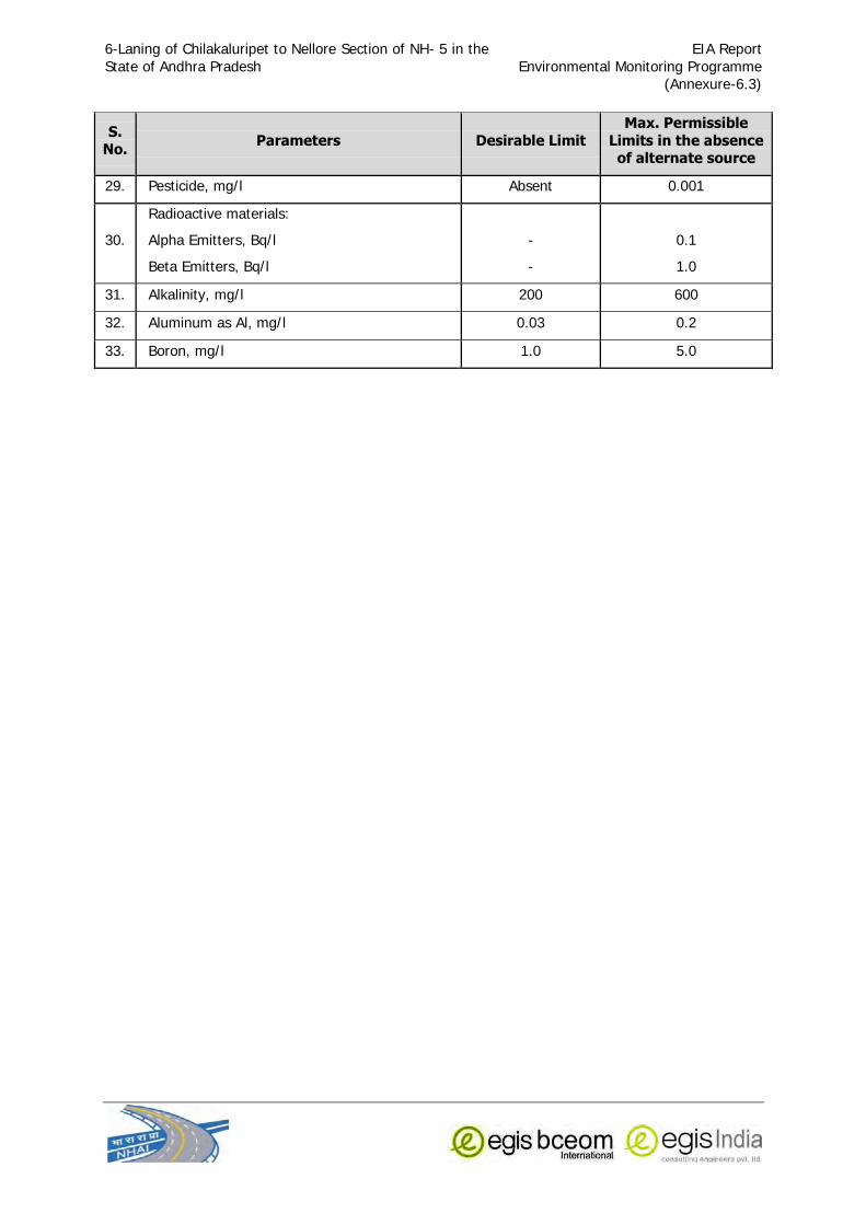
6-Laning of Chilakaluripet to Nellore Section of NH- 5 in the
State of Andhra Pradesh
EIA Report
Environmental Monitoring Programme (Annexure-6.3)
S. No. Parameters Desirable Limit
Max. Permissible Limits in the absence of alternate source
29. Pesticide, mg/l Absent 0.001
30.
Radioactive materials:
Alpha Emitters, Bq/l
Beta Emitters, Bq/l
-
-
0.1
1.0
31. Alkalinity, mg/l 200 600
32. Aluminum as Al, mg/l 0.03 0.2
33. Boron, mg/l 1.0 5.0

6-Laning of Chilakaluripet to Nellore Section of NH- 5 in the
State of Andhra Pradesh
EIA Report
Environmental Monitoring Programme (Annexure-6.4)
ANNEXURE – 6.4
USE BASED CLASSIFICATION OF SURFACE WATERS IN INDIA
Source: Guidelines for Water Quality Management – CPCB 2008.
Designated-Best-Use Class of water Criteria
Drinking Water Source without conventional treatment but after
disinfections
A
i. Total Coliforms Organism MPN/100ml shall be 50 or less
ii. pH between 6.5 and 8.5
iii. Dissolved Oxygen 6mg/l or more
iv. Biochemical Oxygen Demand 5 days 20oC 2mg/l
or less
Outdoor bathing (Organized)
B
i. Total Coliforms Organism MPN/100ml shall be
500 or less
ii. pH between 6.5 and 8.5
iii. Dissolved Oxygen 5mg/l or more
iv. Biochemical Oxygen Demand 5 days 20oC 3mg/l or less
Drinking water source after
conventional treatment and disinfections
C
i. Total Coliforms Organism MPN/100ml shall be
5000 or less
ii. pH between 6 to 9
iii. Dissolved Oxygen 4mg/l or more
iv. Biochemical Oxygen Demand 5 days 20oC
3mg/l or less
Propagation of Wild life and Fisheries
D
i. pH between 6.5 to 8.5
ii. Dissolved Oxygen 4mg/l or more
iii. Free Ammonia (as N) 1.2 mg/l or less
Irrigation, Industrial Cooling, Controlled Waste disposal
E
i. pH between 6.0 to 8.5
ii. Electrical Conductivity at 25oC micro mhos/cm
Max.2250
iii. Sodium absorption Ratio Max. 26
iv. Boron Max. 2mg/l


![DDO Code: 06030702001 [STO Chilakaluripet] Cadre Strength ...gunturbadi.in/DownLoadFiles/Notifications/636826100596749436.pdf · DDO Code: 06030702001 [STO Chilakaluripet] Cadre Strength](https://static.fdocuments.in/doc/165x107/5eb8f158f9972068820c6465/ddo-code-06030702001-sto-chilakaluripet-cadre-strength-ddo-code-06030702001.jpg)