Incorporating GIS in Architectural Pedagogy - Esri...
10
17 th Esri India User Conference 2017 Page 1 of 10 Incorporating GIS in Architectural Pedagogy Dr. Kakoli Saha 1 , Ar. Gayatri Nanda 2 1 Assistant Professor, Dept. of Planning 2 Assistant Professor, Dept. of Architecture School of Planning and Architecture Bhopal, Bhopal, Neelbad Road, Bhauri, Bhopal, MP-462030 Abstract: Geographic Information System (GIS) has significant potentials to contribute in contemporary architectural education, especially in the urban scale to evaluate and design for urban environments. Unfortunately, very few architecture schools in India have incorporated GIS in their academic curriculums. A course on GIS is being conducted at School of Planning and Architecture, Bhopal since the past two years with an objective to analyze qualitative aspects of urban environments with the help of this platform. GIS has been long used in urban planning courses, but the human dimension or perception of built environment has been very less explored by using GIS as a tool. This paper discusses GIS content that can be incorporated in the Masters level courses of Architectural education in India with examples from work done in Master of Urban Design program at SPA, Bhopal. The GIS course is offered to first semester students of Urban Design program. It is composed of Theoretical as well as Application segments. In the Theoretical segment, students learn basic principles of GIS. In the Application segment, students are given GIS lab exercises which include creating & presenting of GIS data, basic editing of attribute data, spatial joins, map overlay, geoprocessing, raster and vector analysis. At the end of the course students are assigned with small GIS based research tasks which require them to use single or multiple strategies based on the complexity of the site to document and analyze its built environment. The research task is always linked to their Urban Design studio so that they can apply GIS techniques to document, visualize, analyze and answer design related queries. The course content was appreciated by both Masters of Urban Design students and the experts. Success of the course points towards the fact that the field of architecture, both in terms of practice and research, may be highly benefitted by GIS, encouraging more architectural schools to adopt GIS in their curriculum. About the Author: Dr. Kakoli Saha Dr. Kakoli Saha is an Assistant Professor at SPA Bhopal. Her expertise includes application of GIS and Remote Sensing in the field of Planning and Architecture. E mail ID: [email protected] Contact: +91-9685537927 Ar. Gayatri Nanda Ar. Gayatri Nanda is an Assistant Professor at School of Planning and Architecture, Bhopal since 2011. She specializes in Urban Design and is pursuing her PhD in ‘Role of Indian cultural event spaces in reinforcing Place-Identity’. E mail ID: [email protected] Contact: +91-8223058854
Transcript of Incorporating GIS in Architectural Pedagogy - Esri...

17th Esri India User Conference 2017
Page 1 of 10
Incorporating GIS in Architectural Pedagogy Dr. Kakoli Saha 1, Ar. Gayatri Nanda 2
1 Assistant Professor, Dept. of Planning 2 Assistant Professor, Dept. of Architecture
School of Planning and Architecture Bhopal, Bhopal, Neelbad Road, Bhauri, Bhopal, MP-462030
Abstract:
Geographic Information System (GIS) has significant potentials to contribute in contemporary architectural education, especially in the urban scale to evaluate and design for urban environments. Unfortunately, very few architecture schools in India have incorporated GIS in their academic curriculums. A course on GIS is being conducted at School of Planning and Architecture, Bhopal since the past two years with an objective to analyze qualitative aspects of urban environments with the help of this platform. GIS has been long used in urban planning courses, but the human dimension or perception of built environment has been very less explored by using GIS as a tool. This paper discusses GIS content that can be incorporated in the Masters level courses of Architectural education in India with examples from work done in Master of Urban Design program at SPA, Bhopal. The GIS course is offered to first semester students of Urban Design program. It is composed of Theoretical as well as Application segments. In the Theoretical segment, students learn basic principles of GIS. In the Application segment, students are given GIS lab exercises which include creating & presenting of GIS data, basic editing of attribute data, spatial joins, map overlay, geoprocessing, raster and vector analysis. At the end of the course students are assigned with small GIS based research tasks which require them to use single or multiple strategies based on the complexity of the site to document and analyze its built environment. The research task is always linked to their Urban Design studio so that they can apply GIS techniques to document, visualize, analyze and answer design related queries. The course content was appreciated by both Masters of Urban Design students and the experts. Success of the course points towards the fact that the field of architecture, both in terms of practice and research, may be highly benefitted by GIS, encouraging more architectural schools to adopt GIS in their curriculum.
About the Author:
Dr. Kakoli Saha
Dr. Kakoli Saha is an Assistant Professor at SPA
Bhopal. Her expertise includes application of GIS and
Remote Sensing in the field of Planning and
Architecture.
E mail ID: [email protected]
Contact: +91-9685537927
Ar. Gayatri Nanda
Ar. Gayatri Nanda is an Assistant Professor at School
of Planning and Architecture, Bhopal since 2011. She
specializes in Urban Design and is pursuing her PhD in
‘Role of Indian cultural event spaces in reinforcing
Place-Identity’.
E mail ID: [email protected]
Contact: +91-8223058854

17th Esri India User Conference 2017
Page 2 of 10
1. Introduction
Geographic Information Systems or GIS were first developed in the early 1960’s. They were no more than a set of innovative computer-based applications for data processing that were used in a small number of government agencies and universities only. Today, GIS has become an important field of academic study. Though GIS has been part of academic curriculum in the disciplines like geography, geology, planning, it is yet to be treated as an integral part of the Architecture curriculum. There is little or no GIS content in most of the architecture programs all around the world (Monsur & Islam, 2014). Specifically in India, GIS is almost nonexistent in architecture pedagogy. The reason can be various. The process of finding the reasons can simply start by looking into broad definitions of two domains. Table 1 contains the broad definitions of Architecture (Merriam-Webster, 2013) and GIS (Lo & Yeung, 2004).
Table 1 Definition of Architecture and GIS
Architecture GIS
The art and science of building, specifically: the art or practice of designing and building structures and especially habitable ones.
A system of hardware, software, and procedures designed to support the capture, management, manipulation, analysis, modeling and display of spatially reference data for solving planning and management problems.
According to table 1, while architecture is a design process, GIS is a way of analyses. Incorporating GIS analysis in the pre-design and post-design phase can make the integration of GIS in Architecture successful. Keeping this in mind, a course has been designed at SPA, Bhopal where qualitative analysis is done in GIS and the outcome is applied to produce design solutions.
2. Course in a nutshell The course is part of Masters of Urban Design program at School of Planning and Architecture, Bhopal. First semester students enrolled in Urban Design program are offered this course.
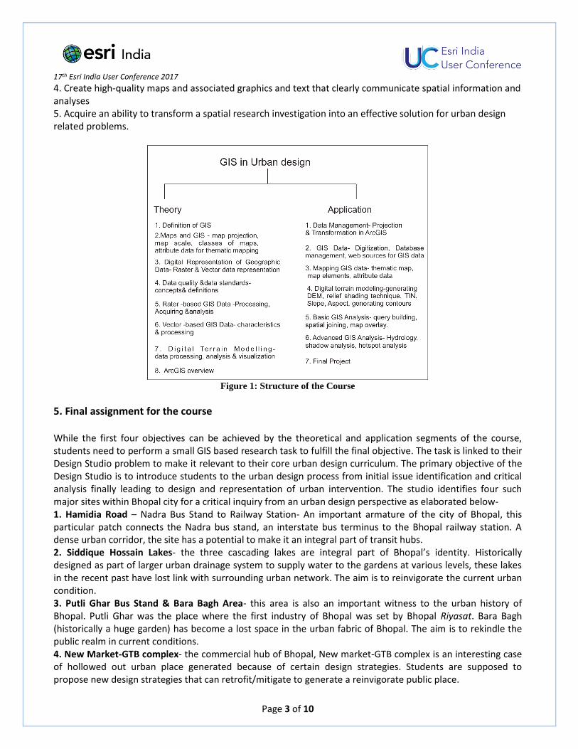
3. Course Description The course introduces the basic concepts and techniques of GIS to architecture students. It is intended to provide students with a foundation for reading, understanding and using basic GIS techniques which are relevant to architectural research. The course is comprised of two basic segments. In the theoretical segment students learn basics of GIS including definition and concepts. In the application segment they learn skill of using GIS tools. Figure 1 elaborates the skills students acquire in the course.
4. Course objectives The course is designed such that by the end of this course students will 1. Understand the data creation process and create simple data sets and/or add to existing data 2. Create spatial data from tabular information that includes a spatial reference 3. Perform basic spatial analyses (attribute and spatial queries, buffering, overlays) as well as linking these methods together in a more complex analytical model.
17th Esri India User Conference 2017
Page 3 of 10
4. Create high-quality maps and associated graphics and text that clearly communicate spatial information and analyses 5. Acquire an ability to transform a spatial research investigation into an effective solution for urban design related problems.
Figure 1: Structure of the Course
5. Final assignment for the course While the first four objectives can be achieved by the theoretical and application segments of the course, students need to perform a small GIS based research task to fulfill the final objective. The task is linked to their Design Studio problem to make it relevant to their core urban design curriculum. The primary objective of the Design Studio is to introduce students to the urban design process from initial issue identification and critical analysis finally leading to design and representation of urban intervention. The studio identifies four such major sites within Bhopal city for a critical inquiry from an urban design perspective as elaborated below- 1. Hamidia Road – Nadra Bus Stand to Railway Station- An important armature of the city of Bhopal, this particular patch connects the Nadra bus stand, an interstate bus terminus to the Bhopal railway station. A dense urban corridor, the site has a potential to make it an integral part of transit hubs. 2. Siddique Hossain Lakes- the three cascading lakes are integral part of Bhopal’s identity. Historically designed as part of larger urban drainage system to supply water to the gardens at various levels, these lakes in the recent past have lost link with surrounding urban network. The aim is to reinvigorate the current urban condition. 3. Putli Ghar Bus Stand & Bara Bagh Area- this area is also an important witness to the urban history of Bhopal. Putli Ghar was the place where the first industry of Bhopal was set by Bhopal Riyasat. Bara Bagh (historically a huge garden) has become a lost space in the urban fabric of Bhopal. The aim is to rekindle the public realm in current conditions. 4. New Market-GTB complex- the commercial hub of Bhopal, New market-GTB complex is an interesting case of hollowed out urban place generated because of certain design strategies. Students are supposed to propose new design strategies that can retrofit/mitigate to generate a reinvigorate public place.
17th Esri India User Conference 2017
Page 4 of 10
The methodology for design and proposal of urban intervention in the given sites involves interpretation and placing of the site, study of the movement and urban form in and around the sites. Various elements like the built fabric, open spaces, activities, road and traffic conditions affect the pedestrian realm. Through this exercise, the aspect of ‘Safety in Urban Environments’ is explored and walkability being a key indicator of safety is accessed in each of the four cases.
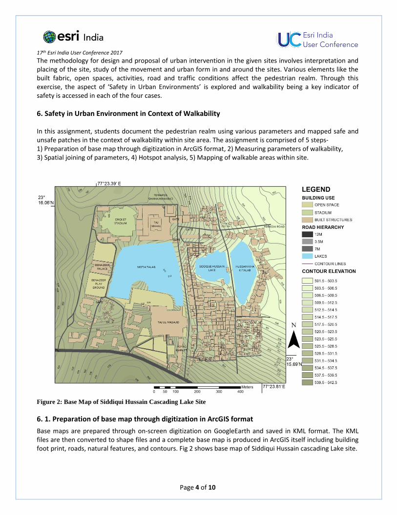
6. Safety in Urban Environment in Context of Walkability In this assignment, students document the pedestrian realm using various parameters and mapped safe and unsafe patches in the context of walkability within site area. The assignment is comprised of 5 steps- 1) Preparation of base map through digitization in ArcGIS format, 2) Measuring parameters of walkability, 3) Spatial joining of parameters, 4) Hotspot analysis, 5) Mapping of walkable areas within site.
Figure 2: Base Map of Siddiqui Hussain Cascading Lake Site
6. 1. Preparation of base map through digitization in ArcGIS format
Base maps are prepared through on-screen digitization on GoogleEarth and saved in KML format. The KML files are then converted to shape files and a complete base map is produced in ArcGIS itself including building foot print, roads, natural features, and contours. Fig 2 shows base map of Siddiqui Hussain cascading Lake site.

17th Esri India User Conference 2017
Page 5 of 10
6. 2. Measuring parameters of walkability
To measure walkability, the site conditions are documented extensively. The site is divided into 50mX50m fishnet grids to record the documentation. Walkability of the sites is measured using following parameters-
Physical condition of pavement: The walking surface, be it the designed paved walkway or the road is studied for evaluating walkable conditions. Each grid is ranked on the Likert scale where the best conditions are ranked 5 and the worst conditions-1.
Distance to Public transport stops: Public transport being generator of pedestrian activity is a major consideration to access the walkability of the site. Therefore, the more connected the grid is to the public transport, i.e. the bus/ auto stands, the higher it is ranked.
Built environment types including building condition, use and interface: The built environment affects the inclination of people to walk along it. Places with high boundary walls, or in dilapidated conditions discourage public activity along these stretches. On the contrary, places which have a positive relation with the pedestrian realm enhancing the ‘eyes on street’ make the environment very conducive for walking. Hence, ranking is done for the built environment in each grid taking into consideration its condition, use and interface.
Activity types and scales: Activity, its types (both formal and informal) and its scales have a repercussion on the pedestrian realm. Compatible activities like street food vendors encourage walkability and vice versa. This parameter is ranked accordingly.
On the basis of the above parameters, each grid is ranked to form several thematic maps.
Figure 3: A- Fishnet grid and B- Attribute Table
6.3. Spatial joining of parameters

17th Esri India User Conference 2017
Page 6 of 10
Fishnet grid contains central points (fig. 3A). Parameters and their ranks are incorporated in the attribute table of central points (fig 3 B). Average of rank values is calculated for each point and added to the attribute table. The average value is used for the subsequent hotspot analysis.
6. 4. Hotspot analysis
Hotspot analysis is performed using grid points as input layer. Hotspot analysis gives a set of weighted
features, identifies statistically significant hot spots and cold spots activities using the Getis-Ord Gi* statistic.
(ArcGIS, 2011) Figure 4 shows the result of Hotspot analysis.
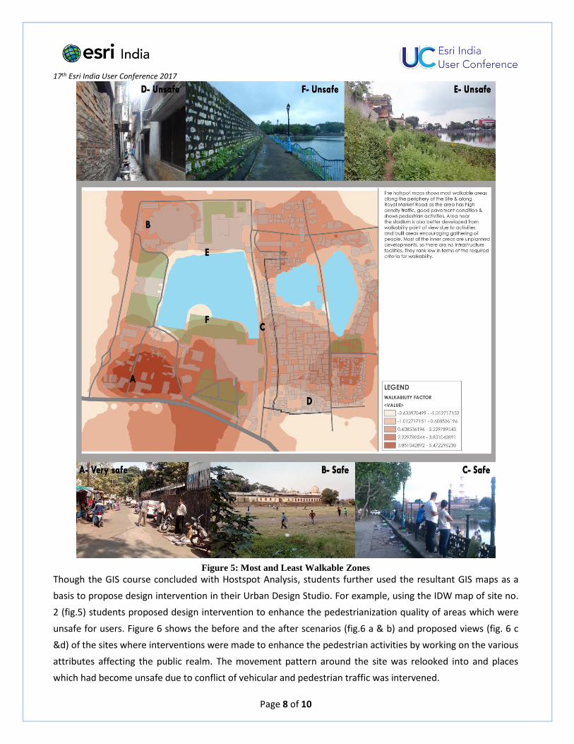
Figure 4: Hot Spot Analysis
According to figure 4, red spots shows the safest and walkable points considering all the parameters while the
blue spots indicates the most unsafe and least walkable areas.
6.5. Mapping of walkable areas within site
To extrapolate the information of individual spots to entire site, Inverse Distance Weighted (IDW) technique is
applied on hotspot layer. The output layer shows continuous layer with most walkable to least walkable zones
(fig.5). This map overlapped on the base map of the site clearly indicates the spatial extents of safe and
unsafe environments indicating the need for interventions in unsafe areas.

17th Esri India User Conference 2017
Page 7 of 10
7. Discussion
Hotspot analysis of all four sites shows that areas with commercial and mixed land use are more walkable
compared to pure residential land use (fig.5). At site no. 3, walkability also scores high at areas along bus stand
where activities are high compared to open space with no activities. At site no. 2 (fig.5), area with unplanned
development scores low in walkability due to lack of infrastructure for walking. Thus different sites point out
areas of safe and unsafe zones caused due to variety of reasons. The IDW maps showing extent of spread of
these zones form a basis for design interventions.
17th Esri India User Conference 2017
Page 8 of 10
Figure 5: Most and Least Walkable Zones
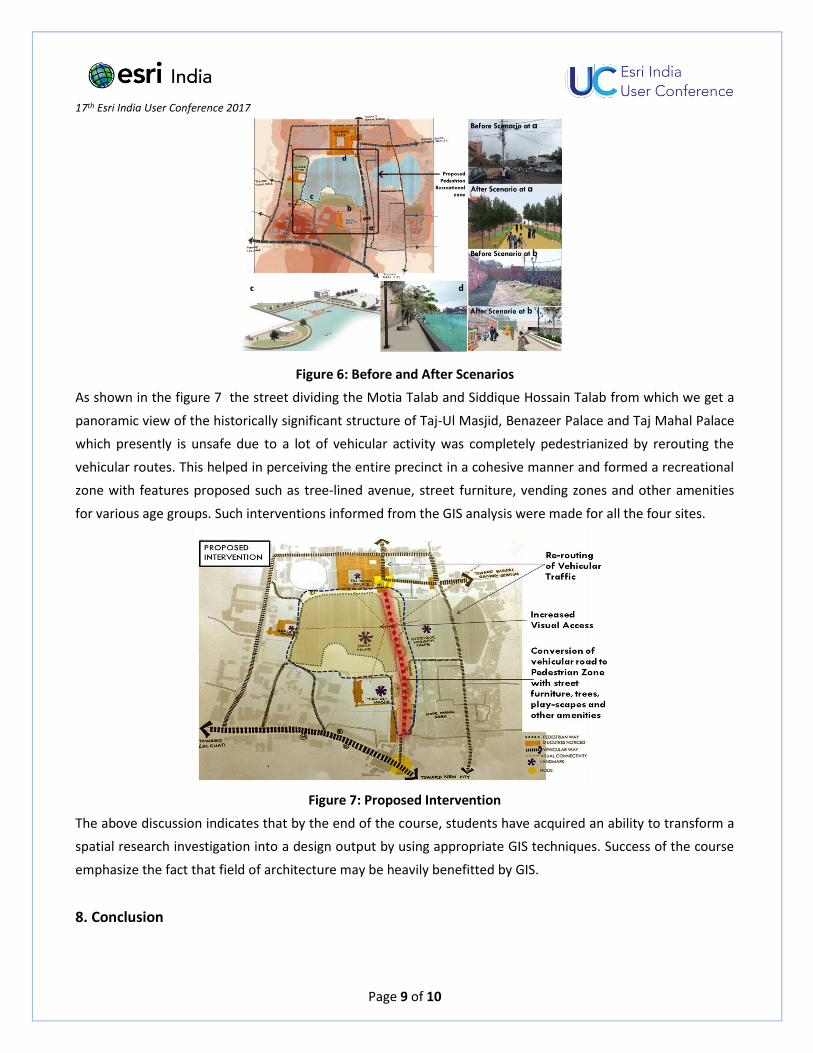
Though the GIS course concluded with Hostspot Analysis, students further used the resultant GIS maps as a
basis to propose design intervention in their Urban Design Studio. For example, using the IDW map of site no.
2 (fig.5) students proposed design intervention to enhance the pedestrianization quality of areas which were
unsafe for users. Figure 6 shows the before and the after scenarios (fig.6 a & b) and proposed views (fig. 6 c
&d) of the sites where interventions were made to enhance the pedestrian activities by working on the various
attributes affecting the public realm. The movement pattern around the site was relooked into and places
which had become unsafe due to conflict of vehicular and pedestrian traffic was intervened.
17th Esri India User Conference 2017
Page 9 of 10
Figure 6: Before and After Scenarios
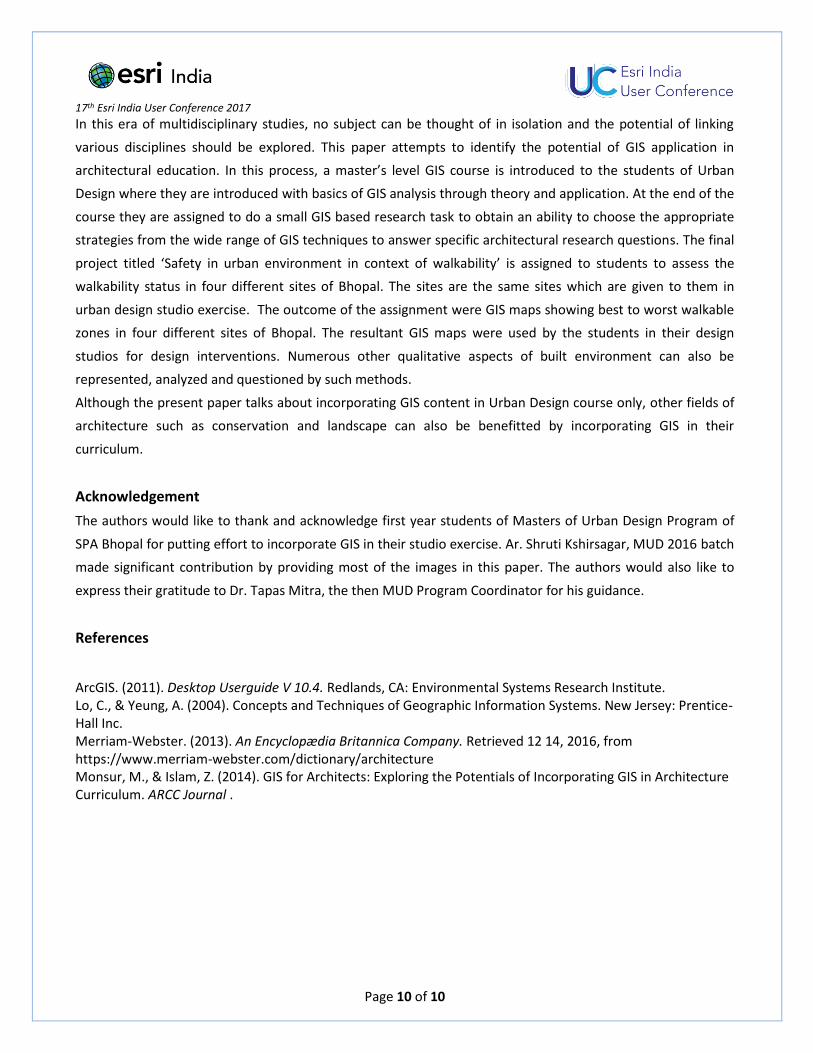
As shown in the figure 7 the street dividing the Motia Talab and Siddique Hossain Talab from which we get a
panoramic view of the historically significant structure of Taj-Ul Masjid, Benazeer Palace and Taj Mahal Palace
which presently is unsafe due to a lot of vehicular activity was completely pedestrianized by rerouting the
vehicular routes. This helped in perceiving the entire precinct in a cohesive manner and formed a recreational
zone with features proposed such as tree-lined avenue, street furniture, vending zones and other amenities
for various age groups. Such interventions informed from the GIS analysis were made for all the four sites.
Figure 7: Proposed Intervention
The above discussion indicates that by the end of the course, students have acquired an ability to transform a
spatial research investigation into a design output by using appropriate GIS techniques. Success of the course
emphasize the fact that field of architecture may be heavily benefitted by GIS.
8. Conclusion
17th Esri India User Conference 2017
Page 10 of 10
In this era of multidisciplinary studies, no subject can be thought of in isolation and the potential of linking
various disciplines should be explored. This paper attempts to identify the potential of GIS application in
architectural education. In this process, a master’s level GIS course is introduced to the students of Urban
Design where they are introduced with basics of GIS analysis through theory and application. At the end of the
course they are assigned to do a small GIS based research task to obtain an ability to choose the appropriate
strategies from the wide range of GIS techniques to answer specific architectural research questions. The final
project titled ‘Safety in urban environment in context of walkability’ is assigned to students to assess the
walkability status in four different sites of Bhopal. The sites are the same sites which are given to them in
urban design studio exercise. The outcome of the assignment were GIS maps showing best to worst walkable
zones in four different sites of Bhopal. The resultant GIS maps were used by the students in their design
studios for design interventions. Numerous other qualitative aspects of built environment can also be
represented, analyzed and questioned by such methods.
Although the present paper talks about incorporating GIS content in Urban Design course only, other fields of
architecture such as conservation and landscape can also be benefitted by incorporating GIS in their
curriculum.
Acknowledgement
The authors would like to thank and acknowledge first year students of Masters of Urban Design Program of
SPA Bhopal for putting effort to incorporate GIS in their studio exercise. Ar. Shruti Kshirsagar, MUD 2016 batch
made significant contribution by providing most of the images in this paper. The authors would also like to
express their gratitude to Dr. Tapas Mitra, the then MUD Program Coordinator for his guidance.
References
ArcGIS. (2011). Desktop Userguide V 10.4. Redlands, CA: Environmental Systems Research Institute. Lo, C., & Yeung, A. (2004). Concepts and Techniques of Geographic Information Systems. New Jersey: Prentice-Hall Inc. Merriam-Webster. (2013). An Encyclopædia Britannica Company. Retrieved 12 14, 2016, from https://www.merriam-webster.com/dictionary/architecture Monsur, M., & Islam, Z. (2014). GIS for Architects: Exploring the Potentials of Incorporating GIS in Architecture Curriculum. ARCC Journal .