INCIDENT - Home | AAIU.ie UK Airbus A320 EI-DIJ... · INCIDENT Aircraft Type and Registration: A...
10
8 © Crown copyrght 2007 AAIB Bulletin: 1/2007 EI-DIJ EW/C2006/03/07 INCIDENT Aircraft Type and Registration: Arbus A320, EI-DIJ No & Type of Engines: 2 CFM 56-3A3 turbofan engnes Year of Manufacture: 992 Date & Time (UTC): 29 March 2006 at 330 hrs Location: Ballykelly, County Londonderry, Northern Ireland Type of Flight: Publc Transport (Passenger) Persons on Board: Crew - 6 Passengers - 39 Injuries: Crew - None Passengers - None Nature of Damage: None Commander’s Licence: Arlne Transport Plot’s Lcence Commander’s Age: 57 years Commander’s Flying Experience: 4,000 hours (of whch ,800 hrs were on type) Last 90 days - 69 hours Last 28 days - 69 hours Information Source: AAIB Feld Investgaton Synopsis The Airbus A320 was operating a scheduled flight from Lverpool (John Lennon) Arport (LPL) to Londonderry/ Eglnton Arport (LDY) n Northern Ireland. At 8 nm from LDY, the operatng crew reported that they were havng problems wth the ILS gldeslope on approach to Runway 26. They judged that they were too hgh to carry out a safe landng from the ILS approach and requested permsson from ATC to carry out a vsual approach. The aircraft then flew a right descending orbt and a vsual crcut, from whch t landed. Upon landng, the crew were advsed by ATC that they had, in fact, landed at Ballykelly Airfield (BKL), 5 nm to the east-north-east of LDY. History of the flight The arcraft was operatng on behalf of another operator. The crew reported at 0455 hrs for a four sector day startng and endng at Lverpool (John Lennon) Arport (LPL). Ther thrd sector was from LPL to Londonderry (LDY); the commander was Plot Flyng (PF) and the co-plot was the Plot Not Flyng (PNF). It was a lmtaton, set by the operatng company, that commanders were to perform the landng and the takeoff at LDY; ths was due to the short runway. A feature of this airfield is that a single track railway line crosses the Runway 26 extended centrelne, very close to the start of the runway, and arcraft nbound to ths runway are sequenced to avod trans.
Transcript of INCIDENT - Home | AAIU.ie UK Airbus A320 EI-DIJ... · INCIDENT Aircraft Type and Registration: A...

8© Crown copyr�ght 2007
AAIB Bulletin: 1/2007 EI-DIJ EW/C2006/03/07
INCIDENT Aircraft Type and Registration: A�rbus A320, EI-DIJ
No & Type of Engines: 2 CFM 56-3A3 turbofan eng�nes
Year of Manufacture: �992
Date & Time (UTC): 29 March 2006 at �330 hrs
Location: Ballykelly, County Londonderry, Northern Ireland
Type of Flight: Publ�c Transport (Passenger)
Persons on Board: Crew - 6 Passengers - 39
Injuries: Crew - None Passengers - None
Nature of Damage: None
Commander’s Licence: A�rl�ne Transport P�lot’s L�cence
Commander’s Age: 57 years
Commander’s Flying Experience: �4,000 hours (of wh�ch �,800 hrs were on type) Last 90 days - 69 hours Last 28 days - 69 hours
Information Source: AAIB F�eld Invest�gat�on
Synopsis
The Airbus A320 was operating a scheduled flight from L�verpool (John Lennon) A�rport (LPL) to Londonderry/Egl�nton A�rport (LDY) �n Northern Ireland. At 8 nm from LDY, the operat�ng crew reported that they were hav�ng problems w�th the ILS gl�deslope on approach to Runway 26. They judged that they were too h�gh to carry out a safe land�ng from the ILS approach and requested perm�ss�on from ATC to carry out a v�sual approach. The aircraft then flew a right descending orb�t and a v�sual c�rcu�t, from wh�ch �t landed. Upon land�ng, the crew were adv�sed by ATC that they had, in fact, landed at Ballykelly Airfield (BKL), 5 nm to the east-north-east of LDY.
History of the flight
The a�rcraft was operat�ng on behalf of another operator.
The crew reported at 0455 hrs for a four sector day start�ng and end�ng at L�verpool (John Lennon) A�rport (LPL). The�r th�rd sector was from LPL to Londonderry (LDY); the commander was P�lot Fly�ng (PF) and the co-p�lot was the P�lot Not Fly�ng (PNF). It was a l�m�tat�on, set by the operat�ng company, that commanders were to perform the land�ng and the takeoff at LDY; th�s was due to the short runway. A feature of this airfield is that a single track railway line crosses the Runway 26 extended centrel�ne, very close to the start of the runway, and a�rcraft �nbound to th�s runway are sequenced to avo�d tra�ns.
9© Crown copyr�ght 2007
AAIB Bulletin: 1/2007 EI-DIJ EW/C2006/03/07
The flight from LPL proceeded uneventfully until
the crew of the A320 was handed over from Scott�sh
Area Control to Egl�nton Approach. Pr�or to the crew
chang�ng frequency, Egl�nton Approach was controll�ng
a Beech 200 a�rcraft, calls�gn CALIBRATOR, that had
just finished calibrating the ILS at LDY and was routing
outbound to a pos�t�on 25 nm east of LDY. The p�lot
of an an Army Gazelle hel�copter then came onto the
frequency stat�ng that he was rout�ng from Colera�ne
(�8 nm east-north-east of LDY) to Londonderry C�ty,
via Ballykelly Airfield (BKL). The Gazelle pilot was
�nformed by ATC of the Beech 200 and that an A320
would soon be com�ng onto frequency and was adv�sed
to stay below �,500 ft amsl and to rema�n south of the
ILS centrel�ne. The p�lot acknowledged these requests.
Upon mak�ng rad�o contact w�th Egl�nton Approach at
�320 hrs, the A320 crew were �nstructed to descend to
3,500 ft amsl and to report ILS local�ser establ�shed at
COLRE, a holding fix 15 nm on Runway 26 extended
centre l�ne at LDY. ATC adv�sed the A320 crew that
a Beech 200 was hold�ng �0 nm east of COLRE, not
above 3,000 ft amsl; th�s was to fac�l�tate the�r arr�val.
At �322 hrs, the hel�copter p�lot reported that he was
3 nm north-east of Bellarena gl�d�ng s�te, 9 nm north-east
of LDY. ATC asked him to fly the last 3 nm to BKL
not above 500 ft agl, as the A320 was on the ILS. Two
m�nutes later, the A320 crew were asked how far they had
to go to COLRE; the crew repl�ed they were establ�shed
on the local�ser. ATC cleared the A320 for an ILS/DME
approach to Runway 26 and to report “PASSING FOUR
DME.” They were then adv�sed that they m�ght see the
hel�copter pass�ng through the BKL overhead from north
to south, not above 500 ft.
The crew of the Beech 200 then requested �f they m�ght
extend outbound to 30 nm before turn�ng �nbound. Th�s
request was approved and ATC �nformed them that the
ILS traffic was now on the localiser at 15 nm and to
report �5 nm �nbound.
At �326 hrs, when the A320 was 8 nm from LDY, the
crew transm�tted “THE ILS ISN’T REALLY GIVING
US DECENT GLIDE PATH INFORMATION. WE’RE
GONNA MAKE A VISUAL APPROACH FROM HERE.
WE’RE SHOWING 8, BUT IT LOOKS A BIT LESS THAN
THAT.” ATC cleared them for the v�sual approach and
�nstructed them to “REPORT ON A 4 MILE FINAL”,
wh�ch they acknowledged. At th�s po�nt the commander
d�sconnected the autop�lot and lowered the nose to
�ncrease the a�rcraft’s rate of descent.
The A320 crew then asked that, if they had to fly a
m�ssed approach, could they jo�n the v�sual c�rcu�t
downw�nd. ATC �nformed them that �t would be a r�ght
hand c�rcu�t and added that there was also a ra�n shower
approach�ng from the northwest. They then sa�d that
they would go-around now and jo�n r�ght hand down
w�nd. ATC requested them to keep �t “REASONABLY
TIGHT”, as they were expect�ng a tra�n �n e�ght m�nutes
and needed to “TRY [to] SQUEEZE YOU IN AHEAD
OF HIM.” Without changing configuration, or pressing
the go-around buttons on the thrust levers, and after
hav�ng re-engaged the autop�lot, the A320 crew started
a descend�ng 360º turn and re-pos�t�oned onto the r�ght
base leg for a v�sual approach to Runway 26.
The A320 crew then asked for a QNH check, wh�ch
was passed, and repl�ed “YEAH THAT CONFIRMS THE
ILS WAS A WAY WAY OUT.” They then added that they
had lost the s�gnal for the ILS too. ATC then �nformed
them that they would talk to the electr�cal eng�neers, but
bel�eved all ILS �nd�cat�ons �n the tower were normal. The
Beech 200 p�lot then transm�tted that he had �nd�cat�ons
that the ILS had been turned off and asked the ATCO to

�0© Crown copyr�ght 2007
AAIB Bulletin: 1/2007 EI-DIJ EW/C2006/03/07
speak to the ground crew. They subsequently confirmed that both ILS transm�tters were funct�on�ng correctly.
As the A320 turned onto r�ght base for Runway 26, ATC �nstructed the crew to “CONTINUE THE APPROACH
AND CALL ON FINAL.” Shortly afterwards the A320 crew reported “AT ABOUT TWO MILES NOW.” At �330 hrs, the ATCO, who was v�sual w�th the A320, then cleared �t to land; th�s was acknowledged by the crew. Shortly before touchdown the EGPWS Mode 5 “GLIDESLOPE” aural warn�ng sounded, followed by a “TERRAIN AHEAD” alert. Due to the d�stract�ng nature of th�s warn�ng, the co-p�lot attempted to s�lence �t by press�ng the TERR OFF button �n the overhead panel.
About 50 seconds later, the ATCO asked the A320 crew to report the�r DME; they repl�ed “WE’VE JUST
TOUCHED DOWN.”, to wh�ch the ATCO responded “IT WAS THE WRONG AIRPORT, YOU’VE LANDED AT
BALLYKELLY.” The A320 crew repl�ed “I KNOW WE
HAVE.” The ATCO then �nstructed them to rema�n on the ground and awa�t further �nstruct�ons.
After complet�ng the land�ng roll, the a�rcraft turned around at the end of the runway. ATC �nstructed the operat�ng crew to shut down the a�rcraft’s eng�nes and awa�t the arr�val of ground handl�ng equ�pment from LDY. The passengers and baggage were subsequently unloaded and taken by road to LDY.
Approval to fly the aircraft out of BKL, using a different operat�ng crew, was subsequently g�ven by the Ir�sh Av�at�on Author�ty, �n conjunct�on w�th the author�t�es at LDY and BKL. The a�rcraft, w�th just an operat�ng crew on board, departed BKL from Runway 02 at �925 hrs after the runway had been measured and �nspected for debr�s.
Flight Recorders
The sources of �nformat�on �nterrogated dur�ng th�s �nvest�gat�on were the Cockp�t Vo�ce Recorder (CVR), the Fl�ght Data Recorder (FDR), the Qu�ck Access Recorder (QAR), the Enhanced Ground Prox�m�ty Warn�ng System (EGPWS) and radar record�ngs.
CVR
The CVR was found to be unserv�ceable, hav�ng fa�led approx�mately �6 days before the �nc�dent. Th�s had not been detected desp�te a requ�rement to carry out a da�ly test.
FDR, QAR and EGPWS
The FDR, QAR and EGPWS y�elded useful �nformat�on perta�n�ng to the �nc�dent and the data correlated well w�th each other. The follow�ng �nformat�on �s an amalgamat�on of these sources.
After departure, the a�rcraft cl�mbed to FL220 and headed north-west. For all but the very first part of the 40 minute flight, the ILS frequency (108.30 MHz) for Runway 26 at Londonderry/Egl�nton was selected. The a�rcraft autop�lots acqu�red the ILS local�zer and gl�deslope and tracked them for approx�mately 2.5 nm before both autop�lots were d�sengaged. The a�rcraft was then flown, using the commander’s sidestick, left of the Londonderry/Egl�nton Runway 26 extended centrel�ne and more �n l�ne w�th the centrel�ne for Runway 26 at Ballykelly. The a�rcraft began to descend below the Londonderry ILS gl�deslope, follow�ng wh�ch a descend�ng orb�t to the r�ght was carr�ed out. Th�s put the aircraft even further below the glideslope. The first half of the orb�t was controlled us�ng the left autop�lot and selected HDG/FPA modes, the second half and subsequent landing was flown manually.
��© Crown copyr�ght 2007
AAIB Bulletin: 1/2007 EI-DIJ EW/C2006/03/07
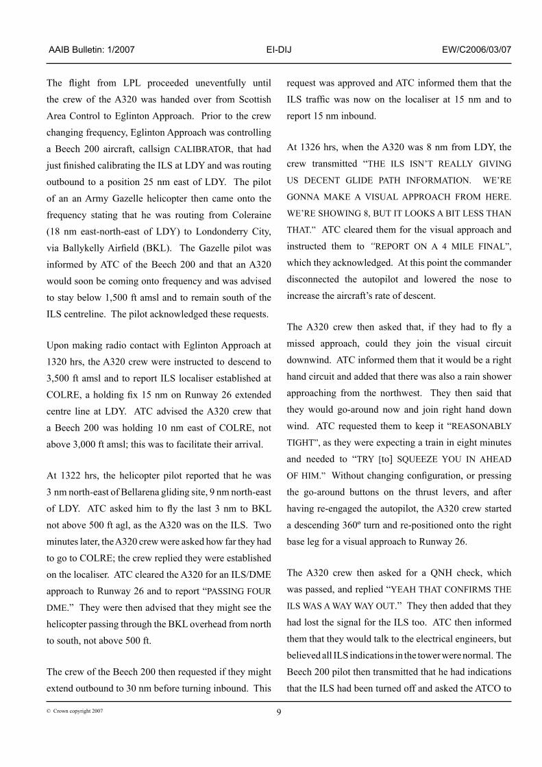
A Mode 5 ‘soft’ EGPWS “GLIDESOPE” alert� was tr�ggered just before the orb�t was complete, at a rad�o alt�tude of approx�mately 592 ft agl. At th�s t�me the glideslope deviation was greater than five dots. Before th�s, the enabl�ng cond�t�ons for a gl�deslope alert had not been met, desp�te the large gl�deslope dev�at�ons2. The descent cont�nued and, ten seconds later, at 509 ft agl, an EGPWS “TERRAIN AHEAD, PULL UP” warn�ng was tr�ggered; wh�ch would have repeated cont�nuously wh�lst the ‘threat’ ex�sted. At the t�me of the alert, the commander had ‘terra�n’ d�splayed on h�s Nav�gat�on D�splay (ND) and th�s alert would have h�ghl�ghted the ‘threaten�ng’ terra�n on h�s d�splay. The co-p�lot d�d not have terra�n d�splayed on h�s ND but the alert would have caused that page to appear. Ten seconds later, at 384 ft agl, the EGPWS look-ahead funct�ons were �nh�b�ted us�ng the TERR OFF select�on on the overhead panel. Th�s �nh�b�ted a further three alerts that would have otherw�se been g�ven. The a�rcraft touched down at Ballykelly 34 seconds later. The Fl�ght Management System pos�t�on �nd�cated that the a�rcraft was w�th�n �75 m of the �ntersect�on of the runways at Ballykelly when the a�rcraft touched down. F�gure � shows the final section of the flight.
Footnotes
� Mode 5 prov�des two levels of alert�ng for when an a�rcraft descends below the gl�deslope, result�ng �n act�vat�on of EGPWS caution lights and aural messages. The first level alert occurs when below �,000 ft and the a�rcraft �s �.3 dots or greater below the beam. Th�s turns on the caut�on l�ghts and �s called a ‘soft’ alert, because the aud�o message ‘GLIDESLOPE’ �s enunc�ated at half volume. 20% �ncreases �n the gl�deslope dev�at�on cause add�t�onal ‘GLIDESLOPE’ messages enunc�ated at a progress�vely faster rate. The second level alert occurs when below 300 ft Rad�o Alt�tude (RA) w�th two dots or greater gl�deslope dev�at�on. Th�s �s called a ‘hard’ alert because a louder ‘GLIDESLOPE GLIDESLOPE’ message �s enunc�ated every three seconds, cont�nu�ng unt�l the ‘hard’ envelope �s ex�ted. The caut�on l�ghts rema�n on unt�l a gl�deslope dev�at�on less than �.3 dots �s ach�eved.2 The alert cond�t�ons requ�re the presence of a val�d local�ser dev�at�on w�th�n two dots and a RA below an upper boundary determ�ned by a comb�nat�on of rate of change of alt�tude and RA.
On th�s a�rcraft, there are no parameters recorded to �dent�fy whether the gl�deslope alert�ng funct�on has been �nh�b�ted, unl�ke the terra�n-ahead warn�ng ment�oned above. Th�s funct�on and �ts assoc�ated button are separate from the terra�n-ahead warn�ng ‘�nh�b�t’ status that was recorded. Had the gl�deslope alert�ng funct�on not been �nh�b�ted then, at 300 ft agl, the status of the alert should have sw�tched from soft to hard and the “GLIDESLOPE GLIDESLOPE” aural warn�ng would have been cont�nuously repeated every three seconds. Airport information
Londonderry’s ma�n runway �s or�entated 26/08. Runway 26 has a LDA of �,8�7 m and �ts threshold �s a short d�stance �nland from the adjacent beach. A s�ngle-track ra�lway l�ne passes through the undershoot area, w�th up to �4 tra�n movements per day, and ra�lway personnel are requ�red to telephone the ATCO at LDY to not�fy the t�me of departure and the est�mated t�me that a tra�n w�ll cross the end of the runway.
As a result, the follow�ng warn�ng �s publ�shed �n the UK Aeronaut�cal Informat�on Package (AIP):
‘Aircraft will not be permitted to land on Runway 26 or depart Runway 08 from 5 minutes before the passage of a train until the train is past. Aircraft may experience approach delays of up to 10 minutes where movements conflict with the passage of a train.’
The approach l�ght�ng for Runway 26 �s 550 m �n length. It initially consists of a line of five high intensity omn�-d�rect�onal sequenced strobe l�ghts, �n the water, supplemented w�th a s�mple ODALS3 system, between the shorel�ne and the threshold.
Footnote
3 Omn� D�rect�onal Approach L�ght�ng System.

�2© Crown copyr�ght 2007
AAIB Bulletin: 1/2007 EI-DIJ EW/C2006/03/07
Figure 1
Approach and Land�ng Sect�on of the Fl�ght der�ved from the Fl�ght Recorders
P�lots are reported to have commented that Runway 26 at Londonderry is very difficult to see from a distance, as the approach l�ghts apparently do not stand out on a br�ght day.
Balllykelly, an ex-RAF airfield, is located 5 nm east-north-east of LDY and �s now used by the Br�t�sh
Army. Unt�l 2003, �t was used by C�30 Hercules a�rcraft and, up to that t�me, the runway was �nspected for condition annually. The airfield mostly supports hel�copter operat�ons and occas�onal Islander a�rcraft training flights and parachute jumping operations. The ma�n runway has the same or�entat�on as LDY, �e 26/08 and Runway 26 �s �,698 m �n length w�th a threshold

�3© Crown copyr�ght 2007
AAIB Bulletin: 1/2007 EI-DIJ EW/C2006/03/07
d�splaced by 479 m, g�v�ng a useable length of �,2�9 m. A ra�lway l�ne, wh�ch �s fenced off, crosses the far end but there �s an add�t�onal 372 m of unusable runway the far s�de of th�s ra�lway.
Runway 26 at BKL �s mostly made of concrete that, �n places, was show�ng s�gns of break-up. A tarmac sect�on �n a good state of repa�r, 662 m �n length, had been la�d �n the m�ddle of the runway. No runway l�ghts were �nstalled.
Only one set of a�rcraft touchdown tyre marks were found on the runway, �e two sets of ‘double’ tyre marks, and these were a short d�stance past the runway des�gnator numbers. Th�s was close to the touchdown pos�t�on computed from the FDR data (see paragraph headed Fl�ght Recorders). The spac�ng between these marks, for both sets of ma�n gear tyres, was measured at 9� cm. The a�rcraft manufacturer reported that, for the A320, th�s d�mens�on �s 92.7 cm. G�ven
Figure 2
Diagram of the layout of Ballykelly Airfield
Figure 3
D�agram of the layout of Londonderry A�rport
that these were the only tyre marks on the runway, the�r locat�on and the�r spac�ng left l�ttle doubt that they had been made by EI-DIJ. Hav�ng landed just past the runway numbers, th�s gave the A320 an adequate amount of runway w�th�n wh�ch to stop; the Land�ng D�stance Requ�red (LDR) for EI-DIJ, at �ts land�ng we�ght, was 728 m.
Meteorological information
The synopt�c s�tuat�on at �200 hrs showed a low pressure over northern parts of the Br�t�sh Isles as well as to the west. Generally good weather was affect�ng much of Northern Ireland
although there was a r�sk of showers �n what was essent�ally an unstable a�r mass.
The METAR �ssued just before EI-DIJ landed at BKL showed that the w�nd was from 250º/�5 kt, the v�s�b�l�ty was �n excess of �0 km, w�th FEW cloud at 2,500 ft agl and SCATTERED cloud at 3,200 ft agl.
�4© Crown copyr�ght 2007
AAIB Bulletin: 1/2007 EI-DIJ EW/C2006/03/07
Operating crew’s comments
Commander
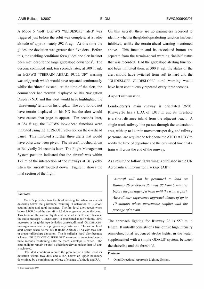
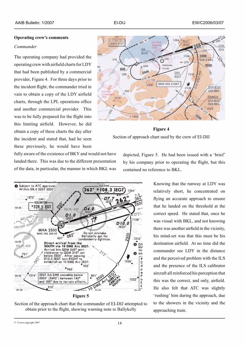
The operat�ng company had prov�ded the operating crew with airfield charts for LDY that had been publ�shed by a commerc�al prov�der, F�gure 4. For three days pr�or to the incident flight, the commander tried in vain to obtain a copy of the LDY airfield charts, through the LPL operations office and another commerc�al prov�der. Th�s was to be fully prepared for the flight into this limiting airfield. However, he did obta�n a copy of these charts the day after the �nc�dent and stated that, had he seen these prev�ously, he would have been fully aware of the ex�stence of BKY and would not have landed there. Th�s was due to the d�fferent presentat�on of the data, �n part�cular, the manner �n wh�ch BKL was
dep�cted, F�gure 5. He had been �ssued w�th a ‘br�ef’ by his company prior to operating the flight, but this conta�ned no reference to BKL.
Know�ng that the runway at LDY was relat�vely short, he concentrated on flying an accurate approach to ensure that he landed on the threshold at the correct speed. He stated that, once he was v�sual w�th BKL, and not know�ng there was another airfield in the vicinity, h�s m�nd-set was that th�s must be h�s destination airfield. At no time did the commander see LDY �n the d�stance and the perce�ved problem w�th the ILS and the presence of the ILS cal�brator a�rcraft all re�nforced h�s percept�on that this was the correct, and only, airfield. He also felt that ATC was sl�ghtly ‘rush�ng’ h�m dur�ng the approach, due to the showers �n the v�c�n�ty and the approach�ng tra�n.
Figure 5
Sect�on of the approach chart that the commander of EI-DIJ attempted to obtain prior to the flight, showing warning note re Ballykelly
Figure 4
Sect�on of approach chart used by the crew of EI-DIJ

�5© Crown copyr�ght 2007
AAIB Bulletin: 1/2007 EI-DIJ EW/C2006/03/07
The commander stated that he touched down close to the beg�nn�ng of the paved surface, well before the marked runway threshold. He was concerned about the length of the runway and wanted to make sure he had the max�mum amount of runway ahead on wh�ch to complete the land�ng roll. He added that, after touchdown, he felt he had an adequate amount of runway ahead of h�m �n wh�ch to stop. The commander was aware of the “GLIDESLOPE” and “TERRAIN” warn�ngs pr�or to land�ng but, as he was v�sual w�th the runway, he bel�eved that they were spur�ous.
Co-pilot
The co-p�lot had landed on Runway 08 at LDY tw�ce before. He was not aware of the ex�stence of BKL and stated that, he too, had the same m�nd-set as the commander. Wh�lst he remembered try�ng to cancel the EGPWS “GLIDESLOPE” warn�ng, he d�d not remember hear�ng the “TERRAIN” warn�ng or wh�ch button he pressed �n the overhead panel.
Londonderry ATC procedures
LDY operates two rad�o frequenc�es, Approach and Tower. There �s no radar fac�l�ty at the a�rport, hence the ATC approach serv�ce �s procedural. When the tower �s staffed, �t �s done so by one ATCO who mon�tors and controls both frequenc�es, wh�ch are cross coupled. Add�t�onally, he �s respons�ble for carry�ng out ‘domest�c’ dut�es that �nclude the tak�ng of land�ng fees, subm�tt�ng flight plans and issuing ATC clearances. When the ATCO requ�res a break, the tower serv�ce closes down.
All a�rcraft land�ng on Runway 26, whether they are flying a visual or an instrument approach, are required to report at four DME. At th�s po�nt, BKL would be beh�nd a land�ng a�rcraft and would thus be out of s�ght to the p�lots. Th�s �s a local order that does not appear �n the Manual of Air Traffic Services Part 2.
ATCO’s comments
In order to de-conflict landing aircraft from the passage of tra�ns, the ATCO plans on a�rcraft tak�ng s�x m�nutes to fly down the ILS from COLRE to touchdown. If a confliction looks likely, he instructs the aircraft to hold at COLRE to �ncrease the separat�on between the a�rcraft and a tra�n.
On be�ng adv�sed by the A320 crew that they had a problem w�th the ILS gl�deslope, the ATCO telephoned the electron�c eng�neers on s�te to ask them to check the serv�ceab�l�ty of the ILS. Although he was v�sual w�th the A320 when �t reported “AT ABOUT TWO
MILES NOW” on final approach, the ATCO did not bel�eve that the a�rcraft was about to land at BKL even though �t appeared “sl�ghtly low”. (At th�s pos�t�on, had the a�rcraft been approach�ng LDY, �t would have been below the gl�deslope by approx�mately 400 ft.) W�th h�nds�ght, the ATCO felt that he had a per�od of approx�mately 30 seconds �n wh�ch �t would have been poss�ble to stop the A320 from land�ng at BKL, but bel�eves that he d�d not do so because he, �ncorrectly, pr�or�t�sed h�s attent�on to check�ng the serv�ceab�l�ty of the ILS. Also, he was look�ng for the Gazelle hel�copter at the time the A320 made its final approach to BKL. He added that, �n the past, he had stopped both l�ght and commerc�al a�rcraft from land�ng at BKL by us�ng h�s D�rect�on F�nd�ng equ�pment, and thus not�c�ng the aircraft’s unusual relative bearing from the airfield. On one occas�on, when he came on duty and was �n the process of hav�ng the controller’s pos�t�on handed over, he stopped a commerc�al a�rcraft from mak�ng th�s m�stake. He attr�buted th�s to the fact that there were two people �n the ATC tower at that t�me.
�6© Crown copyr�ght 2007
AAIB Bulletin: 1/2007 EI-DIJ EW/C2006/03/07
UK Aeronautical Information Package
The Aerodromes sect�on of the UK AIP conta�ns deta�led �nformat�on about c�v�l l�censed aerodromes. Commerc�al providers of airfield charts use this information to produce the�r own vers�on of the charts, wh�ch may be suppl�ed to commerc�al operators and a�rl�nes.
The AIP for Londonderry states the follow�ng under ‘Warnings’:
‘Pilots are reminded of the close proximity of Ballykelly 5 nm to the east-north-east of this aerodrome. Ballykelly runway lighting may be observed from the final approach to Runway 26. Pilots of aircraft en-route and in the circuit should positively identify Londonderry/Eglinton before committing the aircraft to landing.’
On the approach plates for LDY �n the UK AIP, BKL �s dep�cted by a hel�copter land�ng s�te symbol. Th�s �s an ICAO requ�rement due to the fact that the ma�n act�v�ty �s by hel�copters. The �nformat�on �n the AIP �s dep�cted by commerc�al prov�ders �n d�fferent formats and w�th varying amounts of information. The airfield charts, that the commander tried to obtain before the incident flight, dep�ct the runway layout at BKL on all of �ts plates for LDY. They �nclude the note “Do not confuse Ballykelly with Londonderry”, po�nt�ng at th�s symbol, as �llustrated �n F�gure 5. The AIP and commerc�al plates ava�lable to the crew of EI-DIJ d�d not have th�s warn�ng or a dep�ct�on of the runway layout. However, the symbol on these plates d�d �nd�cate that there was an aerodrome at Ballykelly, alongs�de wh�ch �ts name and ICAO code were pr�nted. On other charts, th�s commerc�al prov�der has a symbol �n the chart legend to dep�ct an ‘Aerodrome with a RWY parallel to RWY at procedure aerodrome’. They stated that they had not used th�s to dep�ct the runway at BKL as “no such �nformat�on �s g�ven anywhere �n the UK AIP”.
Analysis
Throughout flying training, pilots are taught to believe their flight instruments unless they have good reason to doubt the �nformat�on be�ng presented. Once v�sual w�th BKL, the crew of the A320 were conv�nced that th�s was the�r destination airfield. Distracted by what they perceived was a problem w�th the ILS gl�deslope and DME, and the perce�ved sl�ght sense of urgency from the ATCO, they became focused on landing at the only airfield they could see. Wh�lst BKL was marked on the�r approach plates, they failed to recognise the depiction as an airfield.
Not being aware that there was another airfield in the v�c�n�ty w�th a very s�m�lar layout, and m�sbel�ev�ng the (correct) ILS gl�deslope and DME �nd�cat�ons, the crew continued towards the only airfield they could see, firmly conv�nced that they were land�ng at LDY. Th�s was desp�te the d�stract�on of the EGPWS warn�ngs dur�ng the final stages of the approach. Had the approach been flown in IMC, there is little doubt that the operating crew would have flown the ILS to Decision Altitude and landed, w�thout �nc�dent, at LDY.
There are vary�ng degrees of �nformat�on and formats assoc�ated w�th the approach plates for LDY from commerc�al prov�ders of th�s �nformat�on. Although at least one vers�on of the approach plates conta�ns a warning note for flight crews not to confuse BKL with LDY, �t would seem appropr�ate that the AIP should be amended to add such a note. Th�s should h�ghl�ght the fact that the runways at BKL have a similar configuration to that of LDY, and th�s would ensure that commerc�al prov�ders have all the �nformat�on they need, to m�n�m�se the possibility of BKL being misidentified as LDY.
Following this incident, National Air Traffic Services (NATS) publ�shed a NOTAM, No L2352/06, wh�ch stated the follow�ng:
�7© Crown copyr�ght 2007
AAIB Bulletin: 1/2007 EI-DIJ EW/C2006/03/07
‘Pilots are reminded of the close proximity of the Military helicopter site at Ballykelly AD, 5 nm east of Londonderry. Ballykelly AD has similar RWY directions and pattern to Londonderry. Pilots of aircraft en-route and in the circuit at Londonderry should positively identify Londonderry/Eglinton before committing their aircraft to land.’
Safety action taken
Pr�or to th�s event, the operat�ng company had been look�ng at the mer�ts of chang�ng to another commerc�al
provider of airfield charts. As a result of this incident,
they have changed the�r prov�der, although the�r or�g�nal
prov�der has now amended �ts charts, �nclud�ng a change
to the symbol for BKL, to clar�fy the �nformat�on
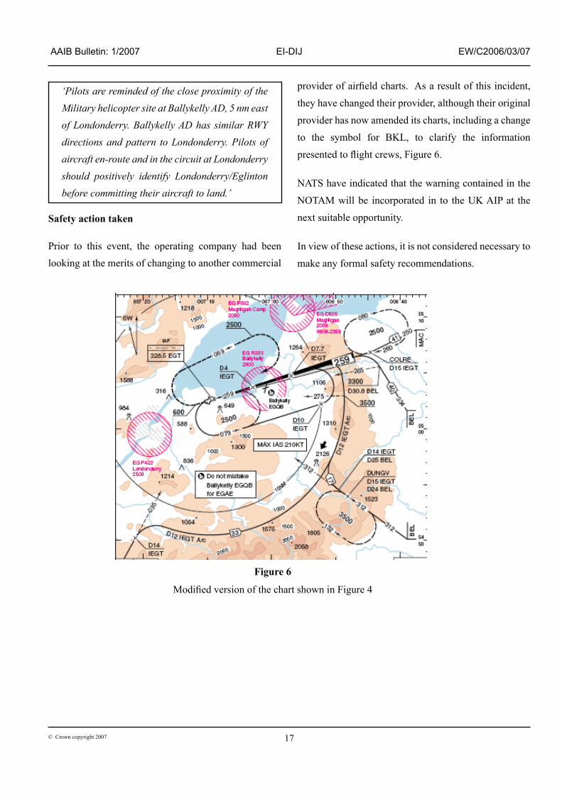
presented to flight crews, Figure 6.
NATS have �nd�cated that the warn�ng conta�ned �n the
NOTAM w�ll be �ncorporated �n to the UK AIP at the
next su�table opportun�ty.
In v�ew of these act�ons, �t �s not cons�dered necessary to
make any formal safety recommendat�ons.
Figure 6
Modified version of the chart shown in Figure 4


![FINAL REPORT SERIOUS INCIDENT TO AIRBUS A320-216 ...FINAL REPORT SERIOUS INCIDENT TO AIRBUS A320-216, REGISTRATION 9M-AQA, RUNWAY EXCURSION 7 JULY 2014 [AAIB BRUNEI 001/2014] Air Accident](https://static.fdocuments.in/doc/165x107/5e782d59b5e019515d28af8d/final-report-serious-incident-to-airbus-a320-216-final-report-serious-incident.jpg)

![A320 [AirlineEconomics]](https://static.fdocuments.in/doc/165x107/544c7f15b1af9fca498b4605/a320-airlineeconomics.jpg)