Inch Cape Offshore Wind Farm, Camperdown Country Park (45.28 km west) and Craigtoun Country Park...
33
Transcript of Inch Cape Offshore Wind Farm, Camperdown Country Park (45.28 km west) and Craigtoun Country Park...
Inch Cape Offshore Wind Farm
Appendix 16A
Seascape, Landscape and Visual Impact Baseline
February 2013
Client Logo
Appendix 16A: Seascape, Landscape and Visual Impact Baseline
ii
Contents
Contents ........................................................................................................................................................... i
List of Tables ................................................................................................................................................... iii
16A Baseline Description of Seascape, Landscape and Visual Amenity Receptors ...................................... 1
16A.1 Settlements ......................................................................................................................................... 1
16A.2 Transportation Links ........................................................................................................................... 2
16A.3 Recreation ........................................................................................................................................... 4
16A.4 Regional Seascape Character Areas and Landscape Character Types and Associated Areas ................ 6
16A.5 Designations ..................................................................................................................................... 21
References ..................................................................................................................................................... 29

Appendix 16A: Seascape, Landscape and Visual Impact Baseline
iii
List of Tables
Table 16A.1: List of Settlements Included in SLVIA ................................................................................ 1
Table 16A.2: Theoretical Visibility of SAs and LCTs within 50 km SLVIA Study Area .............................. 6
Table 16A.3: Description of SAs and LCTs and Associated Areas ........................................................... 8
Table 16A.4: Regional and Local Areas Designated for Landscape Qualities ....................................... 21
Table 16A.5: Gardens and Designed Landscapes ................................................................................. 25
Appendix 16A: Seascape, Landscape and Visual Impact Baseline
Inch Cape Offshore Limited 1 of 29 Offshore Environmental Statement
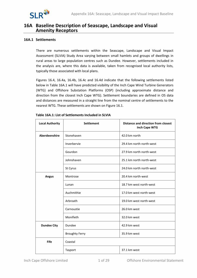
16A Baseline Description of Seascape, Landscape and Visual Amenity Receptors
16A.1 Settlements
There are numerous settlements within the Seascape, Landscape and Visual Impact
Assessment (SLVIA) Study Area varying between small hamlets and groups of dwellings in
rural areas to large population centres such as Dundee. However, settlements included in
the analysis are, where this data is available, taken from recognised local authority lists,
typically those associated with local plans.
Figures 16.4, 16.4a, 16.4b, 16.4c and 16.4d indicate that the following settlements listed
below in Table 16A.1 will have predicted visibility of the Inch Cape Wind Turbine Generators
(WTG) and Offshore Substation Platforms (OSP) (including approximate distance and
direction from the closest Inch Cape WTG). Settlement boundaries are defined in OS data
and distances are measured in a straight line from the nominal centre of settlements to the
nearest WTG. These settlements are shown on Figure 16.1.
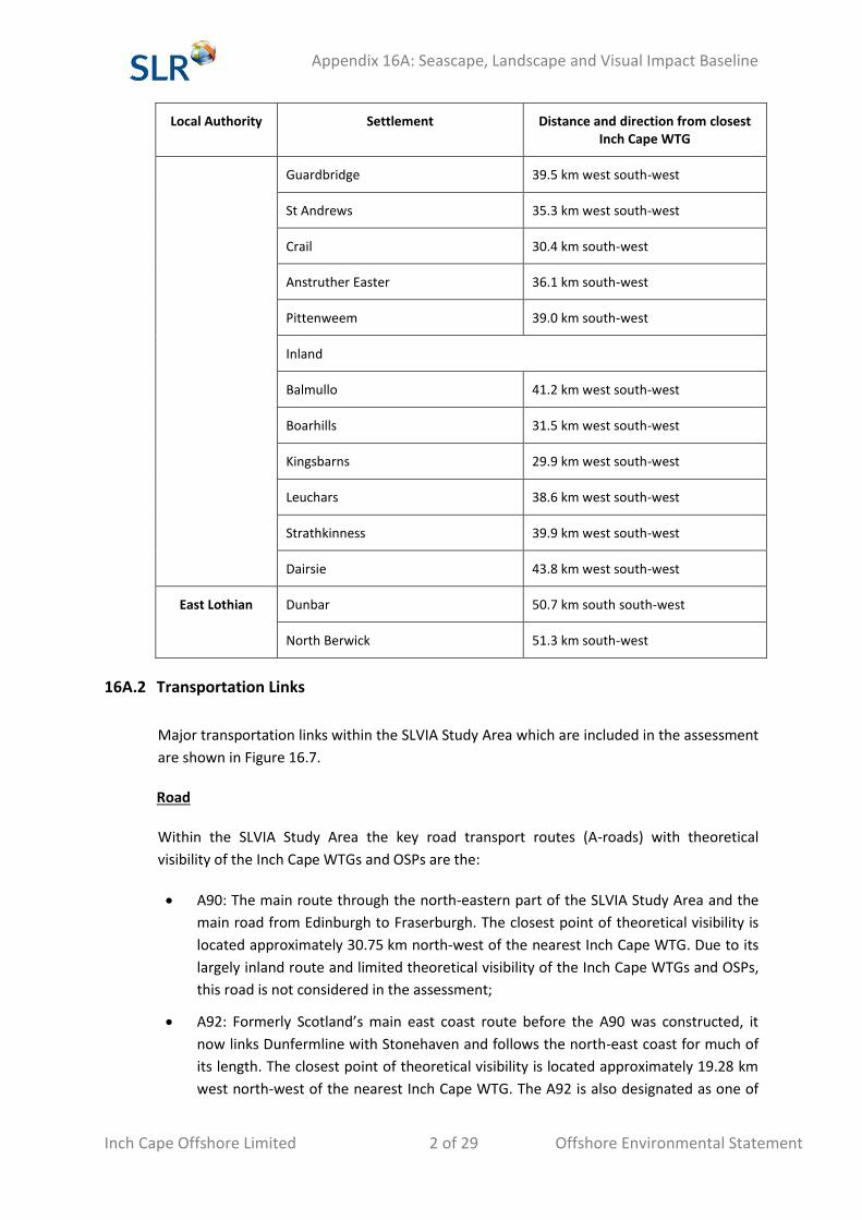
Table 16A.1: List of Settlements Included in SLVIA
Local Authority Settlement Distance and direction from closest Inch Cape WTG
Aberdeenshire Stonehaven 42.0 km north
Inverbervie 29.4 km north north-west
Gourdon 27.9 km north north-west
Johnshaven 25.1 km north north-west
St Cyrus 24.0 km north north-west
Angus Montrose 20.4 km north-west
Lunan 18.7 km west north-west
Auchmithie 17.0 km west north-west
Arbroath 19.0 km west north-west
Carnoustie 26.0 km west
Monifieth 32.0 km west
Dundee City Dundee 42.9 km west
Broughty Ferry 35.9 km west
Fife Coastal
Tayport 37.1 km west
Appendix 16A: Seascape, Landscape and Visual Impact Baseline
Inch Cape Offshore Limited 2 of 29 Offshore Environmental Statement
Local Authority Settlement Distance and direction from closest Inch Cape WTG
Guardbridge 39.5 km west south-west
St Andrews 35.3 km west south-west
Crail 30.4 km south-west
Anstruther Easter 36.1 km south-west
Pittenweem 39.0 km south-west
Inland
Balmullo 41.2 km west south-west
Boarhills 31.5 km west south-west
Kingsbarns 29.9 km west south-west
Leuchars 38.6 km west south-west
Strathkinness 39.9 km west south-west
Dairsie 43.8 km west south-west
East Lothian Dunbar 50.7 km south south-west
North Berwick 51.3 km south-west
16A.2 Transportation Links
Major transportation links within the SLVIA Study Area which are included in the assessment
are shown in Figure 16.7.
Road
Within the SLVIA Study Area the key road transport routes (A-roads) with theoretical
visibility of the Inch Cape WTGs and OSPs are the:
A90: The main route through the north-eastern part of the SLVIA Study Area and the
main road from Edinburgh to Fraserburgh. The closest point of theoretical visibility is
located approximately 30.75 km north-west of the nearest Inch Cape WTG. Due to its
largely inland route and limited theoretical visibility of the Inch Cape WTGs and OSPs,
this road is not considered in the assessment;
A92: Formerly Scotland’s main east coast route before the A90 was constructed, it
now links Dunfermline with Stonehaven and follows the north-east coast for much of
its length. The closest point of theoretical visibility is located approximately 19.28 km
west north-west of the nearest Inch Cape WTG. The A92 is also designated as one of
Appendix 16A: Seascape, Landscape and Visual Impact Baseline
Inch Cape Offshore Limited 3 of 29 Offshore Environmental Statement
Scotland’s National Tourist Routes – the Angus Coastal Route - running between
Dundee and Aberdeen;
A937: Linking Laurencekirk to Montrose. The closest point of theoretical visibility is
located approximately 21.62 km north-west of the nearest Inch Cape WTG;
A935: A short road linking Brechin to Montrose. The closest point of theoretical
visibility is located approximately 21.06 km north-west of the nearest Inch Cape WTG;
A932: Another short road by-passing Forfar town centre. The closest point of
theoretical visibility is located approximately 27.97 km west north-west of the nearest
Inch Cape WTG. Due to its largely inland route and limited theoretical visibility of the
WTGs and OSPs, this road is not considered in the assessment;
A933: Linking Brechin to Arbroath. The closest point of theoretical visibility is located
approximately 20.07 km west north-west of the nearest Inch Cape WTG;
A930: A short stretch of A-road between Dundee and Muirdrum. The closest point of
theoretical visibility is located approximately 25.94 km west of the Development Area.
Field reconnaissance suggests that actual visibility of the Inch Cape WTGs and OSPs
will be limited therefore it is not considered in the assessment;
A914: Linking Muirport to Newport on Tay and by-passing Cupar. The closest point of
theoretical visibility is located approximately 39.61 km west south-west of the nearest
Inch Cape WTG;
A919: Very short road between St Michaels and Guardbridge. The closest point of
theoretical visibility is located approximately 38.68 km west south-west of the nearest
Inch Cape WTG;
A91: Linking St Andrews to Stirling. The closest point of theoretical visibility is located
approximately 35.43 km west south-west of the nearest Inch Cape WTG;
A915: Linking St Andrews to Kirkcaldy. The closest point of theoretical visibility is
located approximately 35.43 km west south-west of the nearest Inch Cape WTG;
A917: Linking Largo to St Andrews. The closest point of theoretical visibility is located
approximately 29.81 km south-west of the nearest Inch Cape WTG. The A917 is also
designated as one of Scotland’s National Tourist Routes – the Fife Coastal Route –
running between Dunfermline and St Andrews; and
A198: A short loop off the A1 from Tyninghame to Tranent via North Berwick. The
closest point of theoretical visibility is located approximately 49.01 km south-west of
the nearest Inch Cape WTG. Due to its distance from the Development Area, this road
is not considered in the assessment.
Rail
The Edinburgh to Aberdeen Line passes through the SLVIA Study Area from Cupar in Fife to
Porthlethen in Aberdeenshire, with predicted visibility for several stretches along the route.
At its closest, the route is located approximately 17.74 km north-west of the nearest Inch
Cape WTG.
Appendix 16A: Seascape, Landscape and Visual Impact Baseline
Inch Cape Offshore Limited 4 of 29 Offshore Environmental Statement
16A.3 Recreation
There are a number of recreational routes within the SLVIA Study Area with potential views
of the Inch Cape WTGs and OSPs including:
The Fife Coastal Path (East Fife). Located approximately 27.42 km south-west of the
nearest Inch Cape WTG at its closest point; and
The John Muir Way (East Lothian). Located approximately 50.34 km south south-west
of the nearest Inch Cape WTG at its closest point. Due to distance from the
Development Area, this path is not considered in the assessment;
There is one main Sustrans cycle route passing through the SLVIA Study Area with potential
views of the Inch Cape WTGs and OSPs:
National Cycle Network (NCN) Route 1, which extends within the SLVIA Study Area
between the south side of the Inner Firth of Tay and Aberdeen. Located approximately
17.31 km west north-west of the nearest Inch Cape WTG at its closest point.
Other recreational facilities with theoretical visibility of the Inch Cape WTGs and OSPs
include numerous golf clubs, caravan parks and campsites, nature reserves, hotels and other
tourist destinations. The following coastal destinations are ordered approximately from the
north to the south of the SLVIA Study Area, with approximate distance to the closest Inch
Cape WTG:
Stonehaven Golf Club (43.78 km);
Dunnottar Castle (40.03 km);
Fowlsheugh Nature Reserve (RSPB) (36.81 km);
Inverbervie Campsite and Caravan Park (29.10 km);
Wairds Park Campsite and Caravan Park (24.96 km);
Miltonhaven Caravan Park (24.01 km);
East Bowstrips Caravan Park (25.11 km);
St Cyrus Holiday Park (24.89 km);
St Cyrus National Nature Reserve (22.95 km);
Montrose Golf Courses (20.50 km);
Seafront Splash (19.74 km);
South Links Holiday Park (19.50 km);
Seaton Cliffs Nature Reserve (Scottish Wildlife Trust) (17.27 km);
Elliot Caravan Park (21.31 km);
Arbroath Artisan Golf Club (21.81 km);
Appendix 16A: Seascape, Landscape and Visual Impact Baseline
Inch Cape Offshore Limited 5 of 29 Offshore Environmental Statement
East Haven Beach and Picnic Area (23.79 km);
Carnoustie Golf Courses (26.84 km);
Panmure Golf Course (29.76 km);
Monifieth Links (31.74 km);
Riverview Caravan Park (32.22 km);
Tayview Caravan and Camping Park (32.87 km);
Broughty Castle (36.10 km);
Tayport Links Caravan Park (39.55 km);
Scotscraig Golf Club (36.74 km);
Tentsmuir Point National Nature Reserve (32.68 km);
Eden Estuary Nature Reserve (33.77 km)
St Andrews Golf Links (35.11 km);
St Andrews Holiday Park (34.45 km);
St Andrews Bay Golf Courses, Hotel and Conference Centre (32.57 km);
Kingsbarns Golf Links (29.23 km);
Balcomie Golf Links (27.96 km);
Craighead Golf Links (27.96 km);
The Kilminning Coast Nature Reserve (28.14 km);
Balcomie Links Caravan Park (30.04 km);
Sauchope Links Caravan Park (29.83 km);
Ashburn House Caravan Site (30.74 km);
Kilrenny Mill Caravan Park (35.99 km);
Anstruther Golf Course (37.78 km);
Glen Golf Course (49.52 km);
Tantallon Castle (48.64 km); and
Dunbar Golf Club (50.38 km).
There are also several country parks located within inland parts of the SLVIA Study Area
having theoretical visibility of the Inch Cape WTGs and OSPs, including Crombie Country
Park (30.0 km west), Monikie Country Park (32.0 km west), Clatto Country Park (45.6 km
west), Camperdown Country Park (45.28 km west) and Craigtoun Country Park (38.44 km
west south-west). The latter two lie within or share part of their site boundary with their
namesake Historic Scotland inventory listed Garden and Designed Landscapes (GDL).
Appendix 16A: Seascape, Landscape and Visual Impact Baseline
Inch Cape Offshore Limited 6 of 29 Offshore Environmental Statement
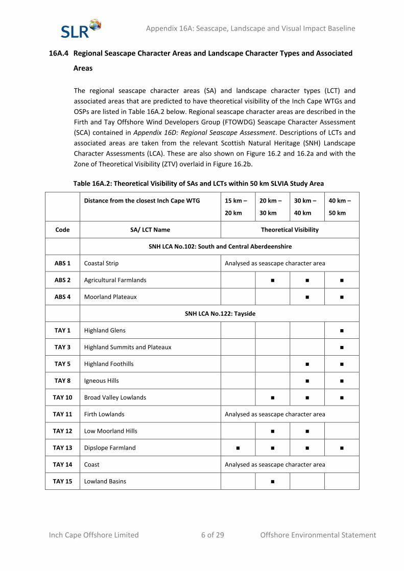
16A.4 Regional Seascape Character Areas and Landscape Character Types and Associated
Areas
The regional seascape character areas (SA) and landscape character types (LCT) and
associated areas that are predicted to have theoretical visibility of the Inch Cape WTGs and
OSPs are listed in Table 16A.2 below. Regional seascape character areas are described in the
Firth and Tay Offshore Wind Developers Group (FTOWDG) Seascape Character Assessment
(SCA) contained in Appendix 16D: Regional Seascape Assessment. Descriptions of LCTs and
associated areas are taken from the relevant Scottish Natural Heritage (SNH) Landscape
Character Assessments (LCA). These are also shown on Figure 16.2 and 16.2a and with the
Zone of Theoretical Visibility (ZTV) overlaid in Figure 16.2b.
Table 16A.2: Theoretical Visibility of SAs and LCTs within 50 km SLVIA Study Area
Distance from the closest Inch Cape WTG 15 km –
20 km
20 km –
30 km
30 km –
40 km
40 km –
50 km
Code SA/ LCT Name Theoretical Visibility
SNH LCA No.102: South and Central Aberdeenshire
ABS 1 Coastal Strip Analysed as seascape character area
ABS 2 Agricultural Farmlands ■ ■ ■
ABS 4 Moorland Plateaux ■ ■
SNH LCA No.122: Tayside
TAY 1 Highland Glens ■
TAY 3 Highland Summits and Plateaux ■
TAY 5 Highland Foothills ■ ■
TAY 8 Igneous Hills ■ ■
TAY 10 Broad Valley Lowlands ■ ■ ■
TAY 11 Firth Lowlands Analysed as seascape character area
TAY 12 Low Moorland Hills ■ ■
TAY 13 Dipslope Farmland ■ ■ ■ ■
TAY 14 Coast Analysed as seascape character area
TAY 15 Lowland Basins ■
Appendix 16A: Seascape, Landscape and Visual Impact Baseline
Inch Cape Offshore Limited 7 of 29 Offshore Environmental Statement
SNH LCA No.113: Fife
FFE 3 Upland Foothills ■ ■
FFE 4 Pronounced Volcanic Hills and Craigs ■ ■
FFE 5 Lowland Hills and Valleys ■ ■
FFE 6 Lowland Open Sloping Farmland ■ ■ ■
FFE 7 Lowland Dens ■ ■
FFE 8 Lowland Glacial Meltwater Valleys ■ ■
FFE 11 Coastal Hills ■ ■
FFE 12 Coastal Terraces ■ ■
FFE 13 Coastal Cliffs Analysed as seascape character area
FFE 14 Coastal Braes Analysed as seascape character area
FFE 15 Coastal Flats ■ ■
FTOWDG SA
SA 3 Cove Bay to Milton Ness ■ ■ ■
SA 4 Montrose Bay ■ ■
SA 5 Long Craig ■
SA 6 Lunan Bay ■
SA 7 Lang Craig to The Deil’s Heid ■
SA 8 Arbroath to Monifieth ■ ■ ■
SA 9 Dundee ■ ■
SA 10 Inner Firth of Tay ■ ■
SA 11 St Andrews Bay ■
SA 12 St Andrews to Fife Ness ■ ■
SA 13 East Neuk of Fife ■ ■
SA 14 Kirkaldy to Largo Bay ■
SA 17 Eyebroughy to Torness Point ■
Appendix 16A: Seascape, Landscape and Visual Impact Baseline
Inch Cape Offshore Limited 8 of 29 Offshore Environmental Statement
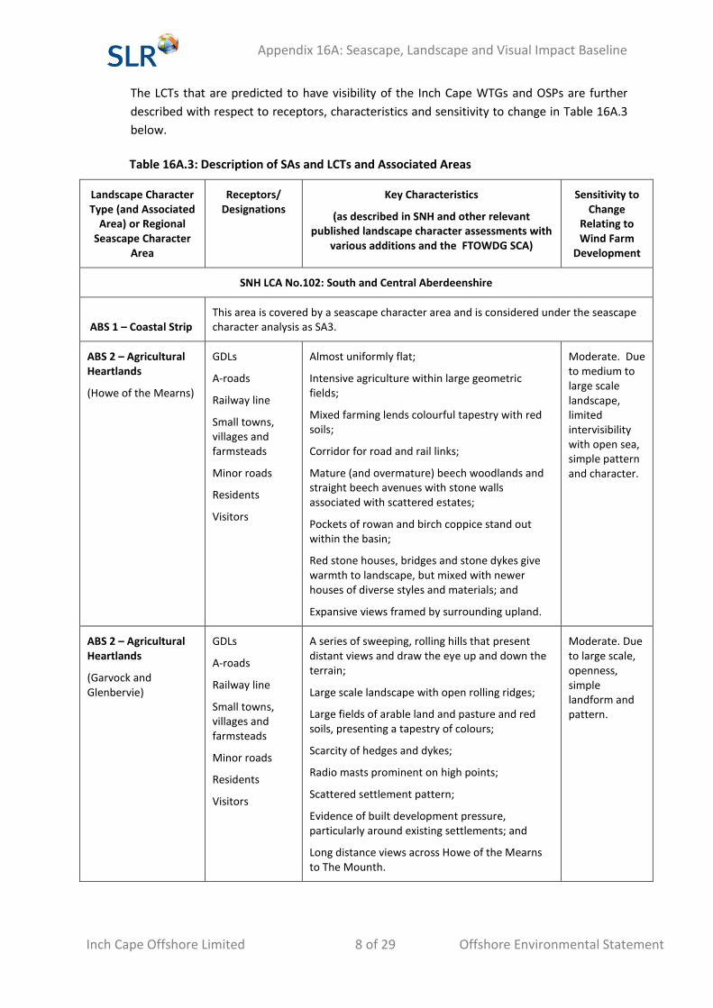
The LCTs that are predicted to have visibility of the Inch Cape WTGs and OSPs are further
described with respect to receptors, characteristics and sensitivity to change in Table 16A.3
below.
Table 16A.3: Description of SAs and LCTs and Associated Areas
Landscape Character Type (and Associated
Area) or Regional Seascape Character
Area
Receptors/ Designations
Key Characteristics
(as described in SNH and other relevant published landscape character assessments with
various additions and the FTOWDG SCA)
Sensitivity to Change
Relating to Wind Farm
Development
SNH LCA No.102: South and Central Aberdeenshire
ABS 1 – Coastal Strip This area is covered by a seascape character area and is considered under the seascape character analysis as SA3.
ABS 2 – Agricultural Heartlands
(Howe of the Mearns)
GDLs
A-roads
Railway line
Small towns, villages and farmsteads
Minor roads
Residents
Visitors
Almost uniformly flat;
Intensive agriculture within large geometric fields;
Mixed farming lends colourful tapestry with red soils;
Corridor for road and rail links;
Mature (and overmature) beech woodlands and straight beech avenues with stone walls associated with scattered estates;
Pockets of rowan and birch coppice stand out within the basin;
Red stone houses, bridges and stone dykes give warmth to landscape, but mixed with newer houses of diverse styles and materials; and
Expansive views framed by surrounding upland.
Moderate. Due to medium to large scale landscape, limited intervisibility with open sea, simple pattern and character.
ABS 2 – Agricultural Heartlands
(Garvock and Glenbervie)
GDLs
A-roads
Railway line
Small towns, villages and farmsteads
Minor roads
Residents
Visitors
A series of sweeping, rolling hills that present distant views and draw the eye up and down the terrain;
Large scale landscape with open rolling ridges;
Large fields of arable land and pasture and red soils, presenting a tapestry of colours;
Scarcity of hedges and dykes;
Radio masts prominent on high points;
Scattered settlement pattern;
Evidence of built development pressure, particularly around existing settlements; and
Long distance views across Howe of the Mearns to The Mounth.
Moderate. Due to large scale, openness, simple landform and pattern.
Appendix 16A: Seascape, Landscape and Visual Impact Baseline
Inch Cape Offshore Limited 9 of 29 Offshore Environmental Statement
Landscape Character Type (and Associated
Area) or Regional Seascape Character
Area
Receptors/ Designations
Key Characteristics
(as described in SNH and other relevant published landscape character assessments with
various additions and the FTOWDG SCA)
Sensitivity to Change
Relating to Wind Farm
Development
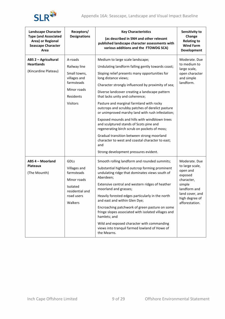
ABS 2 – Agricultural Heartlands
(Kincardine Plateau)
A-roads
Railway line
Small towns, villages and farmsteads
Minor roads
Residents
Visitors
Medium to large scale landscape;
Undulating landform falling gently towards coast;
Sloping relief presents many opportunities for long distance views;
Character strongly influenced by proximity of sea;
Diverse landcover creating a landscape pattern that lacks unity and coherence;
Pasture and marginal farmland with rocky outcrops and scrubby patches of derelict pasture or unimproved marshy land with rush infestation;
Exposed mounds and hills with windblown trees and sculptured stands of Scots pine and regenerating birch scrub on pockets of moss;
Gradual transition between strong moorland character to west and coastal character to east; and
Strong development pressures evident.
Moderate. Due to medium to large scale, open character and simple landform.
ABS 4 – Moorland Plateaux
(The Mounth)
GDLs
Villages and farmsteads
Minor roads
Isolated residential and road users
Walkers
Smooth rolling landform and rounded summits;
Substantial highland outcrop forming prominent undulating ridge that dominates views south of Aberdeen;
Extensive central and western ridges of heather moorland and grasses;
Heavily forested edges particularly in the north and east and within Glen Dye;
Encroaching patchwork of green pasture on some fringe slopes associated with isolated villages and hamlets; and
Wild and exposed character with commanding views into tranquil farmed lowland of Howe of the Mearns.
Moderate. Due to large scale, open and exposed character, simple landform and land cover, and high degree of afforestation.
Appendix 16A: Seascape, Landscape and Visual Impact Baseline
Inch Cape Offshore Limited 10 of 29 Offshore Environmental Statement
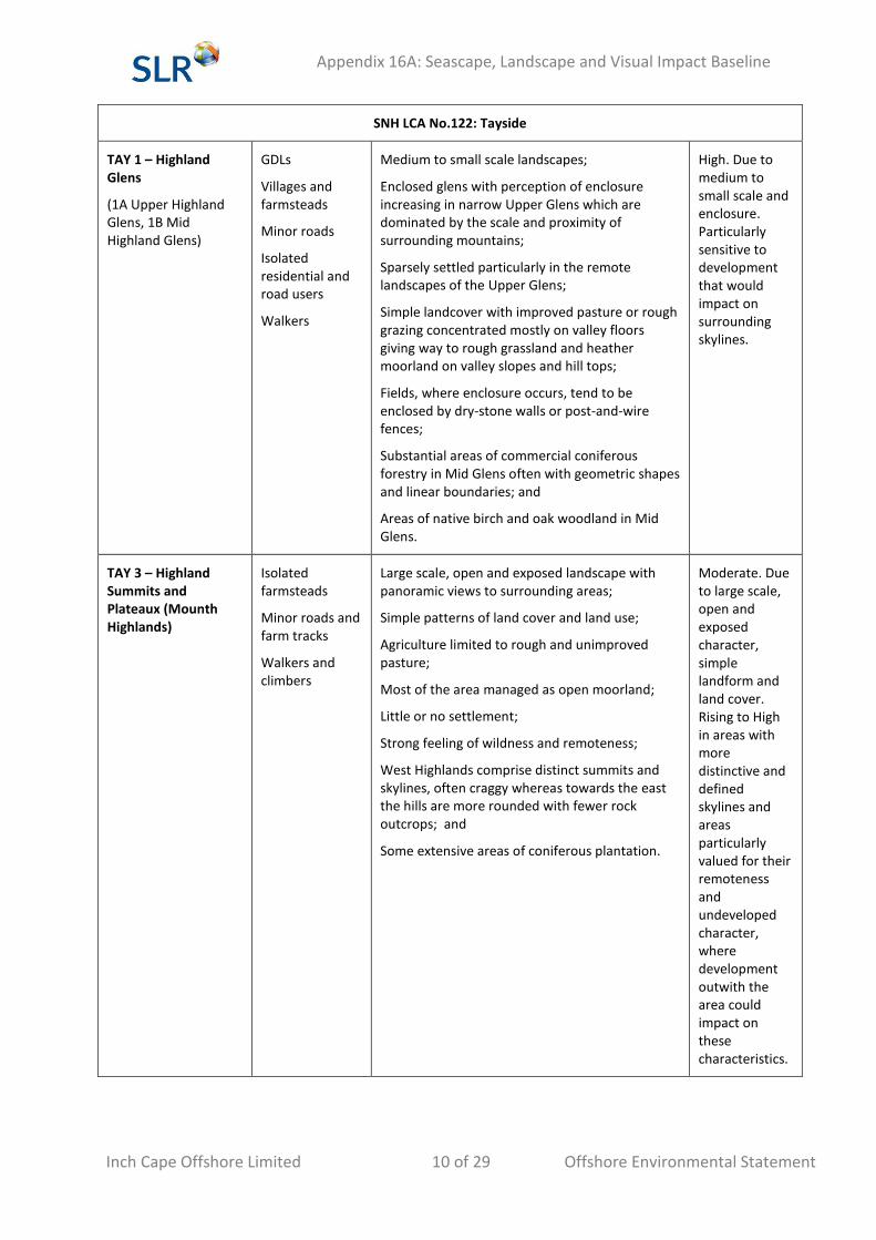
SNH LCA No.122: Tayside
TAY 1 – Highland Glens
(1A Upper Highland Glens, 1B Mid Highland Glens)
GDLs
Villages and farmsteads
Minor roads
Isolated residential and road users
Walkers
Medium to small scale landscapes;
Enclosed glens with perception of enclosure increasing in narrow Upper Glens which are dominated by the scale and proximity of surrounding mountains;
Sparsely settled particularly in the remote landscapes of the Upper Glens;
Simple landcover with improved pasture or rough grazing concentrated mostly on valley floors giving way to rough grassland and heather moorland on valley slopes and hill tops;
Fields, where enclosure occurs, tend to be enclosed by dry-stone walls or post-and-wire fences;
Substantial areas of commercial coniferous forestry in Mid Glens often with geometric shapes and linear boundaries; and
Areas of native birch and oak woodland in Mid Glens.
High. Due to medium to small scale and enclosure. Particularly sensitive to development that would impact on surrounding skylines.
TAY 3 – Highland Summits and Plateaux (Mounth Highlands)
Isolated farmsteads
Minor roads and farm tracks
Walkers and climbers
Large scale, open and exposed landscape with panoramic views to surrounding areas;
Simple patterns of land cover and land use;
Agriculture limited to rough and unimproved pasture;
Most of the area managed as open moorland;
Little or no settlement;
Strong feeling of wildness and remoteness;
West Highlands comprise distinct summits and skylines, often craggy whereas towards the east the hills are more rounded with fewer rock outcrops; and
Some extensive areas of coniferous plantation.
Moderate. Due to large scale, open and exposed character, simple landform and land cover. Rising to High in areas with more distinctive and defined skylines and areas particularly valued for their remoteness and undeveloped character, where development outwith the area could impact on these characteristics.
Appendix 16A: Seascape, Landscape and Visual Impact Baseline
Inch Cape Offshore Limited 11 of 29 Offshore Environmental Statement
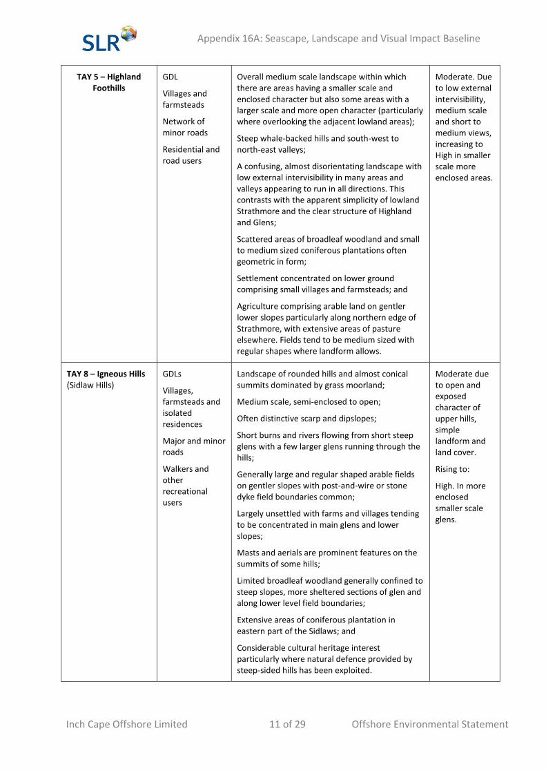
TAY 5 – Highland Foothills
GDL
Villages and farmsteads
Network of minor roads
Residential and road users
Overall medium scale landscape within which there are areas having a smaller scale and enclosed character but also some areas with a larger scale and more open character (particularly where overlooking the adjacent lowland areas);
Steep whale-backed hills and south-west to north-east valleys;
A confusing, almost disorientating landscape with low external intervisibility in many areas and valleys appearing to run in all directions. This contrasts with the apparent simplicity of lowland Strathmore and the clear structure of Highland and Glens;
Scattered areas of broadleaf woodland and small to medium sized coniferous plantations often geometric in form;
Settlement concentrated on lower ground comprising small villages and farmsteads; and
Agriculture comprising arable land on gentler lower slopes particularly along northern edge of Strathmore, with extensive areas of pasture elsewhere. Fields tend to be medium sized with regular shapes where landform allows.
Moderate. Due to low external intervisibility, medium scale and short to medium views, increasing to High in smaller scale more enclosed areas.
TAY 8 – Igneous Hills (Sidlaw Hills)
GDLs
Villages, farmsteads and isolated residences
Major and minor roads
Walkers and other recreational users
Landscape of rounded hills and almost conical summits dominated by grass moorland;
Medium scale, semi-enclosed to open;
Often distinctive scarp and dipslopes;
Short burns and rivers flowing from short steep glens with a few larger glens running through the hills;
Generally large and regular shaped arable fields on gentler slopes with post-and-wire or stone dyke field boundaries common;
Largely unsettled with farms and villages tending to be concentrated in main glens and lower slopes;
Masts and aerials are prominent features on the summits of some hills;
Limited broadleaf woodland generally confined to steep slopes, more sheltered sections of glen and along lower level field boundaries;
Extensive areas of coniferous plantation in eastern part of the Sidlaws; and
Considerable cultural heritage interest particularly where natural defence provided by steep-sided hills has been exploited.
Moderate due to open and exposed character of upper hills, simple landform and land cover.
Rising to:
High. In more enclosed smaller scale glens.
Appendix 16A: Seascape, Landscape and Visual Impact Baseline
Inch Cape Offshore Limited 12 of 29 Offshore Environmental Statement
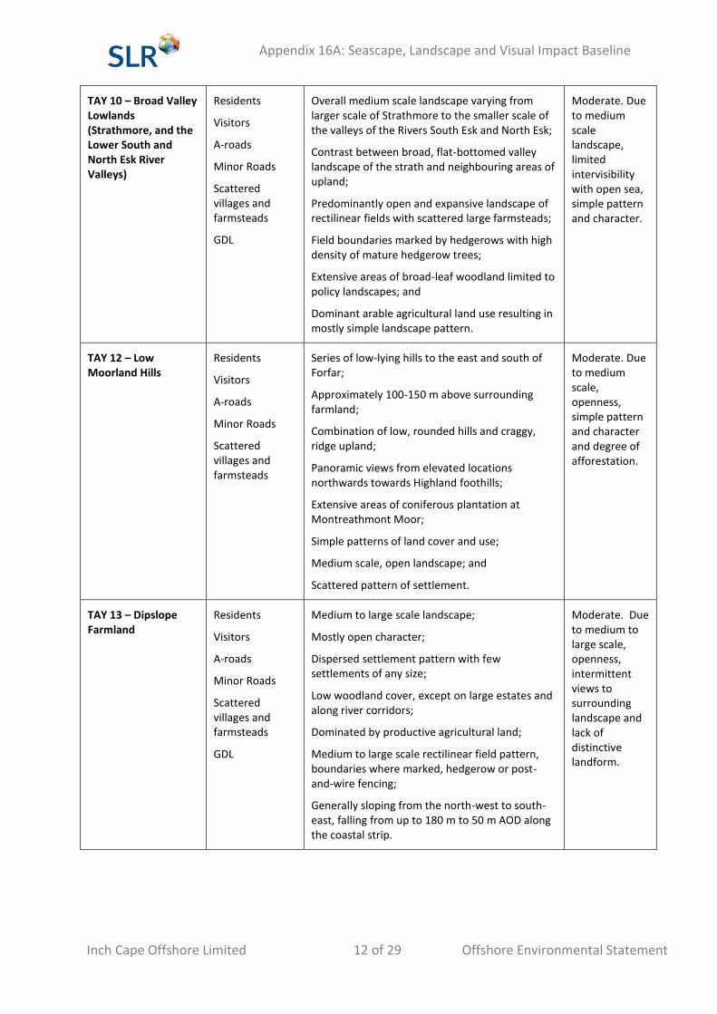
TAY 10 – Broad Valley Lowlands (Strathmore, and the Lower South and North Esk River Valleys)
Residents
Visitors
A-roads
Minor Roads
Scattered villages and farmsteads
GDL
Overall medium scale landscape varying from larger scale of Strathmore to the smaller scale of the valleys of the Rivers South Esk and North Esk;
Contrast between broad, flat-bottomed valley landscape of the strath and neighbouring areas of upland;
Predominantly open and expansive landscape of rectilinear fields with scattered large farmsteads;
Field boundaries marked by hedgerows with high density of mature hedgerow trees;
Extensive areas of broad-leaf woodland limited to policy landscapes; and
Dominant arable agricultural land use resulting in mostly simple landscape pattern.
Moderate. Due to medium scale landscape, limited intervisibility with open sea, simple pattern and character.
TAY 12 – Low Moorland Hills
Residents
Visitors
A-roads
Minor Roads
Scattered villages and farmsteads
Series of low-lying hills to the east and south of Forfar;
Approximately 100-150 m above surrounding farmland;
Combination of low, rounded hills and craggy, ridge upland;
Panoramic views from elevated locations northwards towards Highland foothills;
Extensive areas of coniferous plantation at Montreathmont Moor;
Simple patterns of land cover and use;
Medium scale, open landscape; and
Scattered pattern of settlement.
Moderate. Due to medium scale, openness, simple pattern and character and degree of afforestation.
TAY 13 – Dipslope Farmland
Residents
Visitors
A-roads
Minor Roads
Scattered villages and farmsteads
GDL
Medium to large scale landscape;
Mostly open character;
Dispersed settlement pattern with few settlements of any size;
Low woodland cover, except on large estates and along river corridors;
Dominated by productive agricultural land;
Medium to large scale rectilinear field pattern, boundaries where marked, hedgerow or post-and-wire fencing;
Generally sloping from the north-west to south-east, falling from up to 180 m to 50 m AOD along the coastal strip.
Moderate. Due to medium to large scale, openness, intermittent views to surrounding landscape and lack of distinctive landform.
Appendix 16A: Seascape, Landscape and Visual Impact Baseline
Inch Cape Offshore Limited 13 of 29 Offshore Environmental Statement
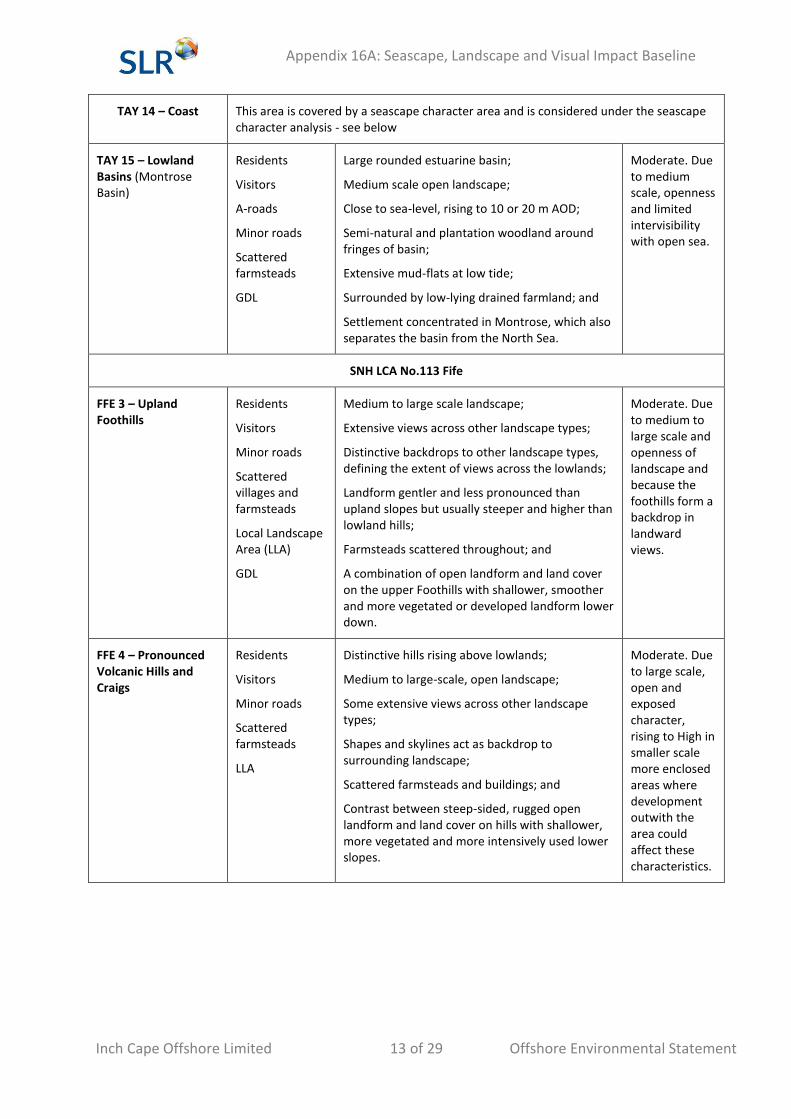
TAY 14 – Coast This area is covered by a seascape character area and is considered under the seascape character analysis - see below
TAY 15 – Lowland Basins (Montrose Basin)
Residents
Visitors
A-roads
Minor roads
Scattered farmsteads
GDL
Large rounded estuarine basin;
Medium scale open landscape;
Close to sea-level, rising to 10 or 20 m AOD;
Semi-natural and plantation woodland around fringes of basin;
Extensive mud-flats at low tide;
Surrounded by low-lying drained farmland; and
Settlement concentrated in Montrose, which also separates the basin from the North Sea.
Moderate. Due to medium scale, openness and limited intervisibility with open sea.
SNH LCA No.113 Fife
FFE 3 – Upland Foothills
Residents
Visitors
Minor roads
Scattered villages and farmsteads
Local Landscape Area (LLA)
GDL
Medium to large scale landscape;
Extensive views across other landscape types;
Distinctive backdrops to other landscape types, defining the extent of views across the lowlands;
Landform gentler and less pronounced than upland slopes but usually steeper and higher than lowland hills;
Farmsteads scattered throughout; and
A combination of open landform and land cover on the upper Foothills with shallower, smoother and more vegetated or developed landform lower down.
Moderate. Due to medium to large scale and openness of landscape and because the foothills form a backdrop in landward views.
FFE 4 – Pronounced Volcanic Hills and Craigs
Residents
Visitors
Minor roads
Scattered farmsteads
LLA
Distinctive hills rising above lowlands;
Medium to large-scale, open landscape;
Some extensive views across other landscape types;
Shapes and skylines act as backdrop to surrounding landscape;
Scattered farmsteads and buildings; and
Contrast between steep-sided, rugged open landform and land cover on hills with shallower, more vegetated and more intensively used lower slopes.
Moderate. Due to large scale, open and exposed character, rising to High in smaller scale more enclosed areas where development outwith the area could affect these characteristics.
Appendix 16A: Seascape, Landscape and Visual Impact Baseline
Inch Cape Offshore Limited 14 of 29 Offshore Environmental Statement
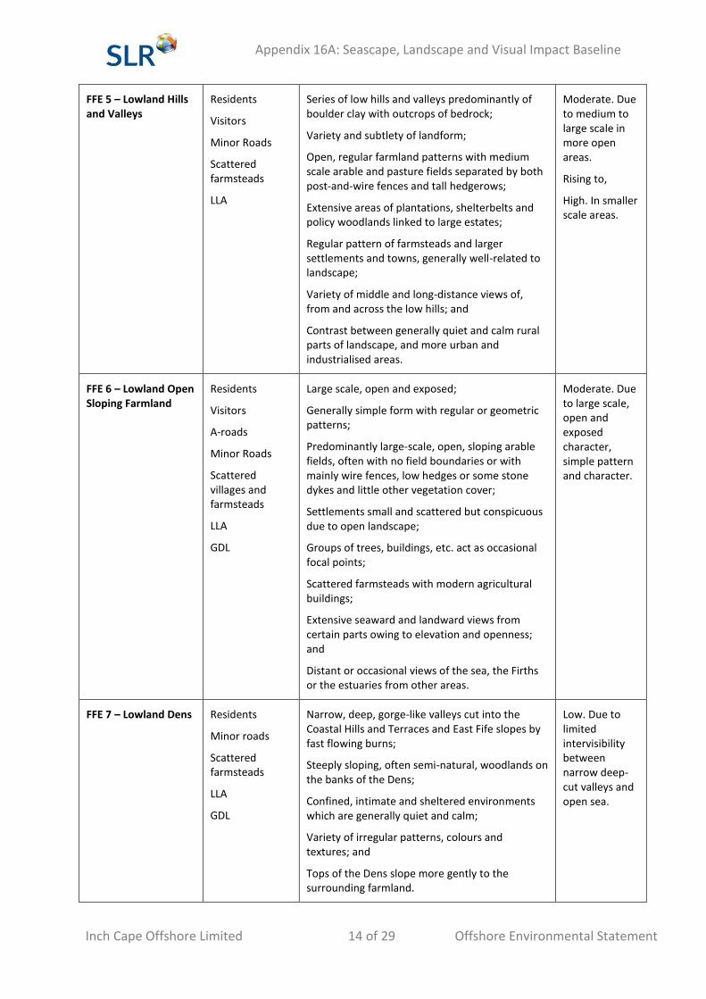
FFE 5 – Lowland Hills and Valleys
Residents
Visitors
Minor Roads
Scattered farmsteads
LLA
Series of low hills and valleys predominantly of boulder clay with outcrops of bedrock;
Variety and subtlety of landform;
Open, regular farmland patterns with medium scale arable and pasture fields separated by both post-and-wire fences and tall hedgerows;
Extensive areas of plantations, shelterbelts and policy woodlands linked to large estates;
Regular pattern of farmsteads and larger settlements and towns, generally well-related to landscape;
Variety of middle and long-distance views of, from and across the low hills; and
Contrast between generally quiet and calm rural parts of landscape, and more urban and industrialised areas.
Moderate. Due to medium to large scale in more open areas.
Rising to,
High. In smaller scale areas.
FFE 6 – Lowland Open Sloping Farmland
Residents
Visitors
A-roads
Minor Roads
Scattered villages and farmsteads
LLA
GDL
Large scale, open and exposed;
Generally simple form with regular or geometric patterns;
Predominantly large-scale, open, sloping arable fields, often with no field boundaries or with mainly wire fences, low hedges or some stone dykes and little other vegetation cover;
Settlements small and scattered but conspicuous due to open landscape;
Groups of trees, buildings, etc. act as occasional focal points;
Scattered farmsteads with modern agricultural buildings;
Extensive seaward and landward views from certain parts owing to elevation and openness; and
Distant or occasional views of the sea, the Firths or the estuaries from other areas.
Moderate. Due to large scale, open and exposed character, simple pattern and character.
FFE 7 – Lowland Dens Residents
Minor roads
Scattered farmsteads
LLA
GDL
Narrow, deep, gorge-like valleys cut into the Coastal Hills and Terraces and East Fife slopes by fast flowing burns;
Steeply sloping, often semi-natural, woodlands on the banks of the Dens;
Confined, intimate and sheltered environments which are generally quiet and calm;
Variety of irregular patterns, colours and textures; and
Tops of the Dens slope more gently to the surrounding farmland.
Low. Due to limited intervisibility between narrow deep-cut valleys and open sea.
Appendix 16A: Seascape, Landscape and Visual Impact Baseline
Inch Cape Offshore Limited 15 of 29 Offshore Environmental Statement
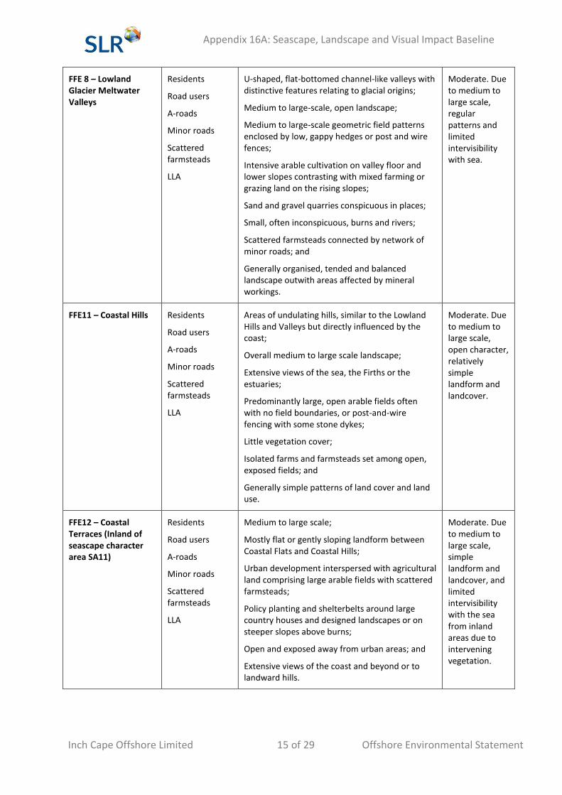
FFE 8 – Lowland Glacier Meltwater Valleys
Residents
Road users
A-roads
Minor roads
Scattered farmsteads
LLA
U-shaped, flat-bottomed channel-like valleys with distinctive features relating to glacial origins;
Medium to large-scale, open landscape;
Medium to large-scale geometric field patterns enclosed by low, gappy hedges or post and wire fences;
Intensive arable cultivation on valley floor and lower slopes contrasting with mixed farming or grazing land on the rising slopes;
Sand and gravel quarries conspicuous in places;
Small, often inconspicuous, burns and rivers;
Scattered farmsteads connected by network of minor roads; and
Generally organised, tended and balanced landscape outwith areas affected by mineral workings.
Moderate. Due to medium to large scale, regular patterns and limited intervisibility with sea.
FFE11 – Coastal Hills Residents
Road users
A-roads
Minor roads
Scattered farmsteads
LLA
Areas of undulating hills, similar to the Lowland Hills and Valleys but directly influenced by the coast;
Overall medium to large scale landscape;
Extensive views of the sea, the Firths or the estuaries;
Predominantly large, open arable fields often with no field boundaries, or post-and-wire fencing with some stone dykes;
Little vegetation cover;
Isolated farms and farmsteads set among open, exposed fields; and
Generally simple patterns of land cover and land use.
Moderate. Due to medium to large scale, open character, relatively simple landform and landcover.
FFE12 – Coastal Terraces (Inland of seascape character area SA11)
Residents
Road users
A-roads
Minor roads
Scattered farmsteads
LLA
Medium to large scale;
Mostly flat or gently sloping landform between Coastal Flats and Coastal Hills;
Urban development interspersed with agricultural land comprising large arable fields with scattered farmsteads;
Policy planting and shelterbelts around large country houses and designed landscapes or on steeper slopes above burns;
Open and exposed away from urban areas; and
Extensive views of the coast and beyond or to landward hills.
Moderate. Due to medium to large scale, simple landform and landcover, and limited intervisibility with the sea from inland areas due to intervening vegetation.
Appendix 16A: Seascape, Landscape and Visual Impact Baseline
Inch Cape Offshore Limited 16 of 29 Offshore Environmental Statement
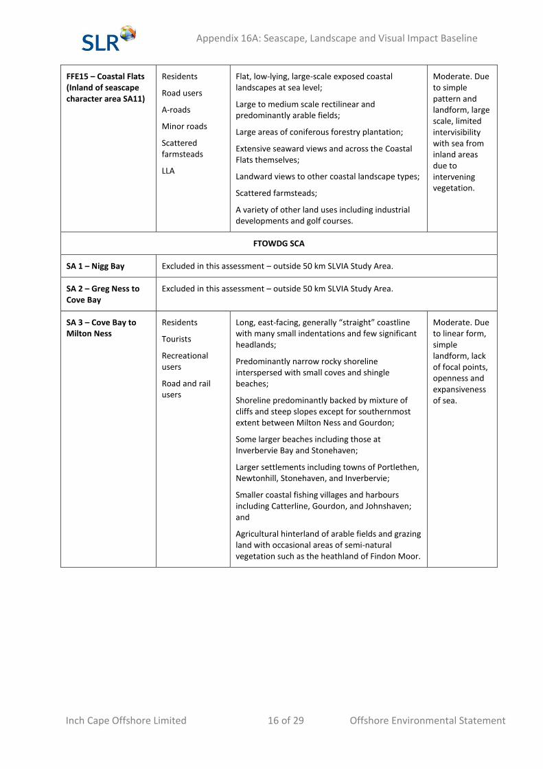
FFE15 – Coastal Flats (Inland of seascape character area SA11)
Residents
Road users
A-roads
Minor roads
Scattered farmsteads
LLA
Flat, low-lying, large-scale exposed coastal landscapes at sea level;
Large to medium scale rectilinear and predominantly arable fields;
Large areas of coniferous forestry plantation;
Extensive seaward views and across the Coastal Flats themselves;
Landward views to other coastal landscape types;
Scattered farmsteads;
A variety of other land uses including industrial developments and golf courses.
Moderate. Due to simple pattern and landform, large scale, limited intervisibility with sea from inland areas due to intervening vegetation.
FTOWDG SCA
SA 1 – Nigg Bay Excluded in this assessment – outside 50 km SLVIA Study Area.
SA 2 – Greg Ness to Cove Bay
Excluded in this assessment – outside 50 km SLVIA Study Area.
SA 3 – Cove Bay to Milton Ness
Residents
Tourists
Recreational users
Road and rail users
Long, east-facing, generally “straight” coastline with many small indentations and few significant headlands;
Predominantly narrow rocky shoreline interspersed with small coves and shingle beaches;
Shoreline predominantly backed by mixture of cliffs and steep slopes except for southernmost extent between Milton Ness and Gourdon;
Some larger beaches including those at Inverbervie Bay and Stonehaven;
Larger settlements including towns of Portlethen, Newtonhill, Stonehaven, and Inverbervie;
Smaller coastal fishing villages and harbours including Catterline, Gourdon, and Johnshaven; and
Agricultural hinterland of arable fields and grazing land with occasional areas of semi-natural vegetation such as the heathland of Findon Moor.
Moderate. Due to linear form, simple landform, lack of focal points, openness and expansiveness of sea.
Appendix 16A: Seascape, Landscape and Visual Impact Baseline
Inch Cape Offshore Limited 17 of 29 Offshore Environmental Statement
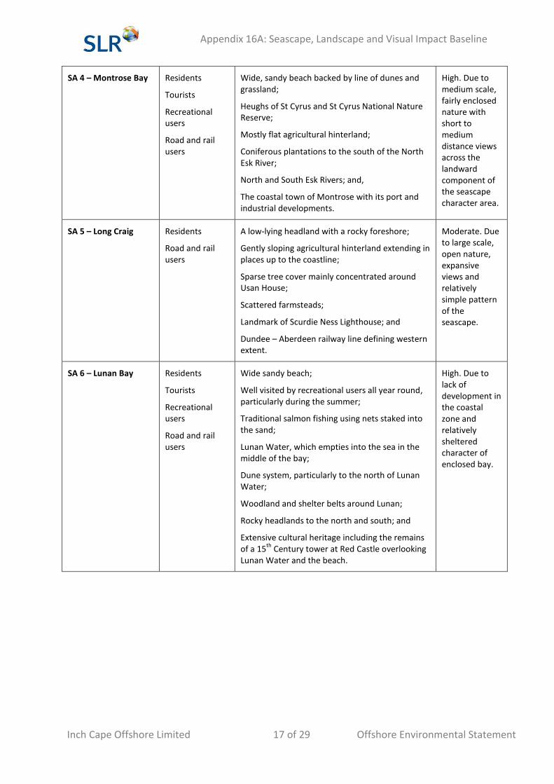
SA 4 – Montrose Bay Residents
Tourists
Recreational users
Road and rail users
Wide, sandy beach backed by line of dunes and grassland;
Heughs of St Cyrus and St Cyrus National Nature Reserve;
Mostly flat agricultural hinterland;
Coniferous plantations to the south of the North Esk River;
North and South Esk Rivers; and,
The coastal town of Montrose with its port and industrial developments.
High. Due to medium scale, fairly enclosed nature with short to medium distance views across the landward component of the seascape character area.
SA 5 – Long Craig Residents
Road and rail users
A low-lying headland with a rocky foreshore;
Gently sloping agricultural hinterland extending in places up to the coastline;
Sparse tree cover mainly concentrated around Usan House;
Scattered farmsteads;
Landmark of Scurdie Ness Lighthouse; and
Dundee – Aberdeen railway line defining western extent.
Moderate. Due to large scale, open nature, expansive views and relatively simple pattern of the seascape.
SA 6 – Lunan Bay Residents
Tourists
Recreational users
Road and rail users
Wide sandy beach;
Well visited by recreational users all year round, particularly during the summer;
Traditional salmon fishing using nets staked into the sand;
Lunan Water, which empties into the sea in the middle of the bay;
Dune system, particularly to the north of Lunan Water;
Woodland and shelter belts around Lunan;
Rocky headlands to the north and south; and
Extensive cultural heritage including the remains of a 15
th Century tower at Red Castle overlooking
Lunan Water and the beach.
High. Due to lack of development in the coastal zone and relatively sheltered character of enclosed bay.
Appendix 16A: Seascape, Landscape and Visual Impact Baseline
Inch Cape Offshore Limited 18 of 29 Offshore Environmental Statement
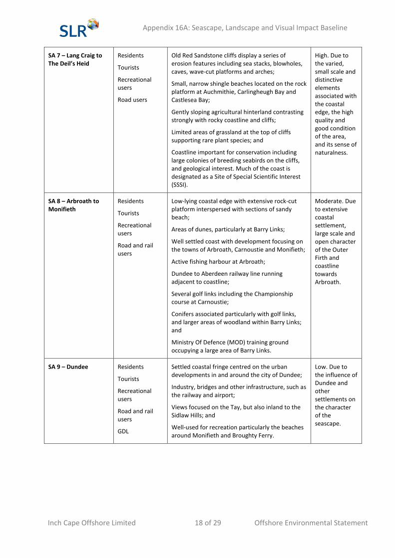
SA 7 – Lang Craig to The Deil’s Heid
Residents
Tourists
Recreational users
Road users
Old Red Sandstone cliffs display a series of erosion features including sea stacks, blowholes, caves, wave-cut platforms and arches;
Small, narrow shingle beaches located on the rock platform at Auchmithie, Carlingheugh Bay and Castlesea Bay;
Gently sloping agricultural hinterland contrasting strongly with rocky coastline and cliffs;
Limited areas of grassland at the top of cliffs supporting rare plant species; and
Coastline important for conservation including large colonies of breeding seabirds on the cliffs, and geological interest. Much of the coast is designated as a Site of Special Scientific Interest (SSSI).
High. Due to the varied, small scale and distinctive elements associated with the coastal edge, the high quality and good condition of the area, and its sense of naturalness.
SA 8 – Arbroath to Monifieth
Residents
Tourists
Recreational users
Road and rail users
Low-lying coastal edge with extensive rock-cut platform interspersed with sections of sandy beach;
Areas of dunes, particularly at Barry Links;
Well settled coast with development focusing on the towns of Arbroath, Carnoustie and Monifieth;
Active fishing harbour at Arbroath;
Dundee to Aberdeen railway line running adjacent to coastline;
Several golf links including the Championship course at Carnoustie;
Conifers associated particularly with golf links, and larger areas of woodland within Barry Links; and
Ministry Of Defence (MOD) training ground occupying a large area of Barry Links.
Moderate. Due to extensive coastal settlement, large scale and open character of the Outer Firth and coastline towards Arbroath.
SA 9 – Dundee Residents
Tourists
Recreational users
Road and rail users
GDL
Settled coastal fringe centred on the urban developments in and around the city of Dundee;
Industry, bridges and other infrastructure, such as the railway and airport;
Views focused on the Tay, but also inland to the Sidlaw Hills; and
Well-used for recreation particularly the beaches around Monifieth and Broughty Ferry.
Low. Due to the influence of Dundee and other settlements on the character of the seascape.
Appendix 16A: Seascape, Landscape and Visual Impact Baseline
Inch Cape Offshore Limited 19 of 29 Offshore Environmental Statement
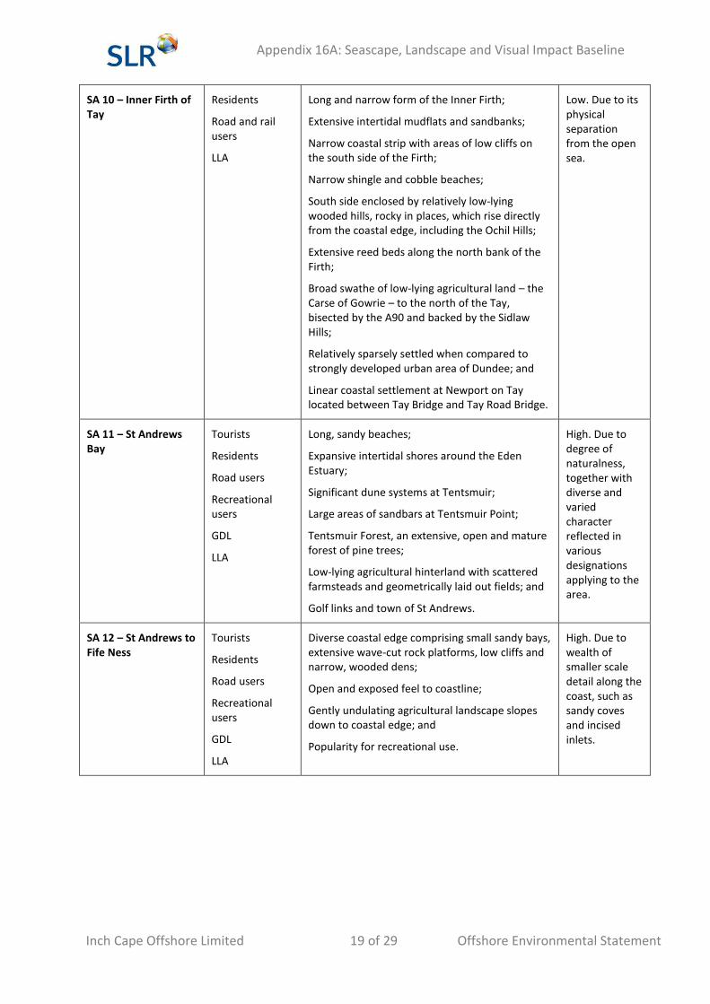
SA 10 – Inner Firth of Tay
Residents
Road and rail users
LLA
Long and narrow form of the Inner Firth;
Extensive intertidal mudflats and sandbanks;
Narrow coastal strip with areas of low cliffs on the south side of the Firth;
Narrow shingle and cobble beaches;
South side enclosed by relatively low-lying wooded hills, rocky in places, which rise directly from the coastal edge, including the Ochil Hills;
Extensive reed beds along the north bank of the Firth;
Broad swathe of low-lying agricultural land – the Carse of Gowrie – to the north of the Tay, bisected by the A90 and backed by the Sidlaw Hills;
Relatively sparsely settled when compared to strongly developed urban area of Dundee; and
Linear coastal settlement at Newport on Tay located between Tay Bridge and Tay Road Bridge.
Low. Due to its physical separation from the open sea.
SA 11 – St Andrews Bay
Tourists
Residents
Road users
Recreational users
GDL
LLA
Long, sandy beaches;
Expansive intertidal shores around the Eden Estuary;
Significant dune systems at Tentsmuir;
Large areas of sandbars at Tentsmuir Point;
Tentsmuir Forest, an extensive, open and mature forest of pine trees;
Low-lying agricultural hinterland with scattered farmsteads and geometrically laid out fields; and
Golf links and town of St Andrews.
High. Due to degree of naturalness, together with diverse and varied character reflected in various designations applying to the area.
SA 12 – St Andrews to Fife Ness
Tourists
Residents
Road users
Recreational users
GDL
LLA
Diverse coastal edge comprising small sandy bays, extensive wave-cut rock platforms, low cliffs and narrow, wooded dens;
Open and exposed feel to coastline;
Gently undulating agricultural landscape slopes down to coastal edge; and
Popularity for recreational use.
High. Due to wealth of smaller scale detail along the coast, such as sandy coves and incised inlets.
Appendix 16A: Seascape, Landscape and Visual Impact Baseline
Inch Cape Offshore Limited 20 of 29 Offshore Environmental Statement
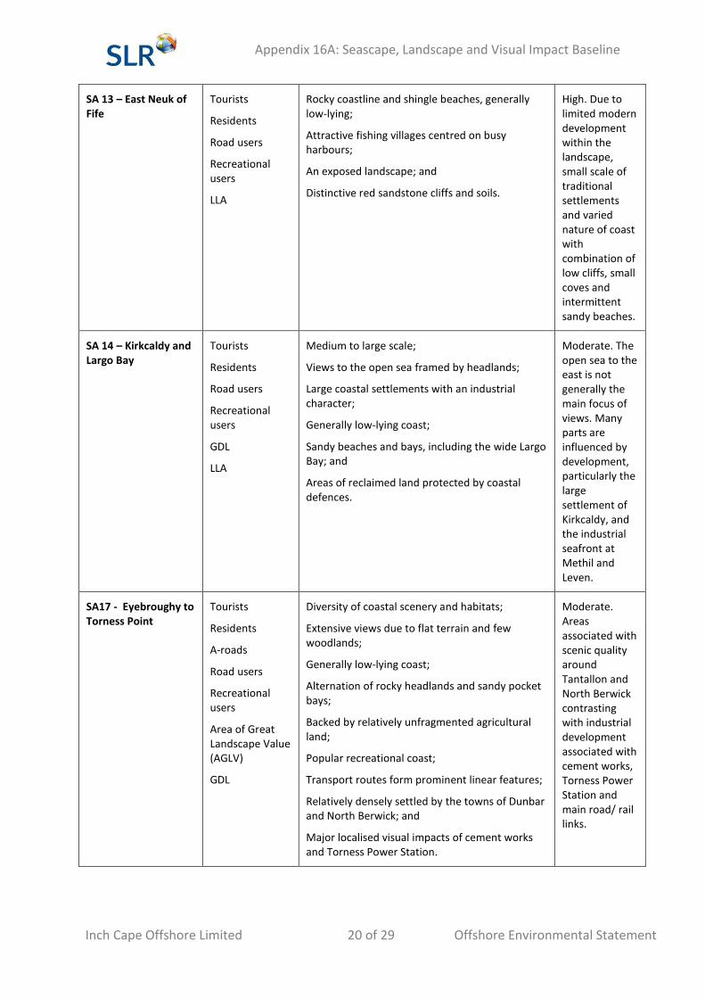
SA 13 – East Neuk of Fife
Tourists
Residents
Road users
Recreational users
LLA
Rocky coastline and shingle beaches, generally low-lying;
Attractive fishing villages centred on busy harbours;
An exposed landscape; and
Distinctive red sandstone cliffs and soils.
High. Due to limited modern development within the landscape, small scale of traditional settlements and varied nature of coast with combination of low cliffs, small coves and intermittent sandy beaches.
SA 14 – Kirkcaldy and Largo Bay
Tourists
Residents
Road users
Recreational users
GDL
LLA
Medium to large scale;
Views to the open sea framed by headlands;
Large coastal settlements with an industrial character;
Generally low-lying coast;
Sandy beaches and bays, including the wide Largo Bay; and
Areas of reclaimed land protected by coastal defences.
Moderate. The open sea to the east is not generally the main focus of views. Many parts are influenced by development, particularly the large settlement of Kirkcaldy, and the industrial seafront at Methil and Leven.
SA17 - Eyebroughy to Torness Point
Tourists
Residents
A-roads
Road users
Recreational users
Area of Great Landscape Value (AGLV)
GDL
Diversity of coastal scenery and habitats;
Extensive views due to flat terrain and few woodlands;
Generally low-lying coast;
Alternation of rocky headlands and sandy pocket bays;
Backed by relatively unfragmented agricultural land;
Popular recreational coast;
Transport routes form prominent linear features;
Relatively densely settled by the towns of Dunbar and North Berwick; and
Major localised visual impacts of cement works and Torness Power Station.
Moderate. Areas associated with scenic quality around Tantallon and North Berwick contrasting with industrial development associated with cement works, Torness Power Station and main road/ rail links.
Appendix 16A: Seascape, Landscape and Visual Impact Baseline
Inch Cape Offshore Limited 21 of 29 Offshore Environmental Statement
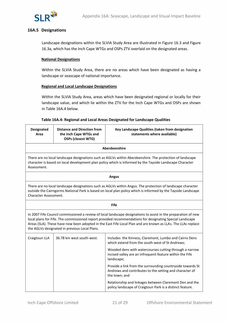
16A.5 Designations
Landscape designations within the SLVIA Study Area are illustrated in Figure 16.3 and Figure
16.3a, which has the Inch Cape WTGs and OSPs ZTV overlaid on the designated areas.
National Designations
Within the SLVIA Study Area, there are no areas which have been designated as having a
landscape or seascape of national importance.
Regional and Local Landscape Designations
Within the SLVIA Study Area, areas which have been designated regional or locally for their
landscape value, and which lie within the ZTV for the Inch Cape WTGs and OSPs are shown
in Table 16A.4 below.
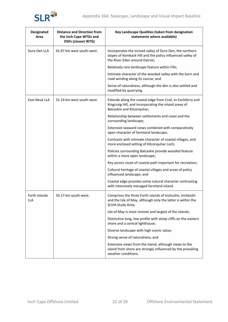
Table 16A.4: Regional and Local Areas Designated for Landscape Qualities
Designated Area
Distance and Direction from the Inch Cape WTGs and
OSPs (closest WTG)
Key Landscape Qualities (taken from designation statements where available)
Aberdeenshire
There are no local landscape designations such as AGLVs within Aberdeenshire. The protection of landscape character is based on local development plan policy which is informed by the Tayside Landscape Character Assessment.
Angus
There are no local landscape designations such as AGLVs within Angus. The protection of landscape character outside the Cairngorms National Park is based on local plan policy which is informed by the Tayside Landscape Character Assessment.
Fife
In 2007 Fife Council commissioned a review of local landscape designations to assist in the preparation of new local plans for Fife. The commissioned report provided recommendations for designating Special Landscape Areas (SLA). These have now been adopted in the East Fife Local Plan and are known as LLAs. The LLAs replace the AGLVs designated in previous Local Plans.
Craigtoun LLA 36.78 km west south-west. Includes the Kinness, Claremont, Lumbo and Cairns Dens which extend from the south-west of St Andrews;
Wooded dens with watercourses cutting through a narrow incised valley are an infrequent feature within the Fife landscape;
Provide a link from the surrounding countryside towards St Andrews and contributes to the setting and character of the town; and
Relationship and linkages between Claremont Den and the policy landscape of Craigtoun Park is a distinct feature.
Appendix 16A: Seascape, Landscape and Visual Impact Baseline
Inch Cape Offshore Limited 22 of 29 Offshore Environmental Statement
Designated Area
Distance and Direction from the Inch Cape WTGs and
OSPs (closest WTG)
Key Landscape Qualities (taken from designation statements where available)
Dura Den LLA 41.97 km west south-west. Incorporates the incised valley of Dura Den, the northern slopes of Kemback Hill and the policy influenced valley of the River Eden around Dairsie;
Relatively rare landscape feature within Fife;
Intimate character of the wooded valley with the burn and road winding along its course; and
Sense of naturalness, although the den is also settled and modified by quarrying.
East Neuk LLA 31.14 km west south-west. Extends along the coastal edge from Crail, to Earlsferry and Kingcraig Hill, and incorporating the inland areas of Balcaskie and Kilconquhar;
Relationship between settlements and coast and the surrounding landscape;
Extensive seaward views combined with comparatively open character of farmland landscape;
Contrasts with intimate character of coastal villages, and more enclosed setting of Kilconquhar Loch;
Policies surrounding Balcaskie provide wooded feature within a more open landscape;
Key access route of coastal path important for recreation;
Cultural heritage of coastal villages and areas of policy influenced landscape; and
Coastal edge provides some natural character contrasting with intensively managed farmland inland.
Forth Islands LLA
33.17 km south-west. Comprises the three Forth islands of Inchcolm, Inchkeith and the Isle of May, although only the latter is within the SLVIA Study Area;
Isle of May is most remote and largest of the islands;
Distinctive long, low profile with steep cliffs on the eastern shore and a central lighthouse;
Diverse landscape with high scenic value;
Strong sense of naturalness; and
Extensive views from the island, although views to the island from shore are strongly influenced by the prevailing weather conditions.
Appendix 16A: Seascape, Landscape and Visual Impact Baseline
Inch Cape Offshore Limited 23 of 29 Offshore Environmental Statement
Designated Area
Distance and Direction from the Inch Cape WTGs and
OSPs (closest WTG)
Key Landscape Qualities (taken from designation statements where available)
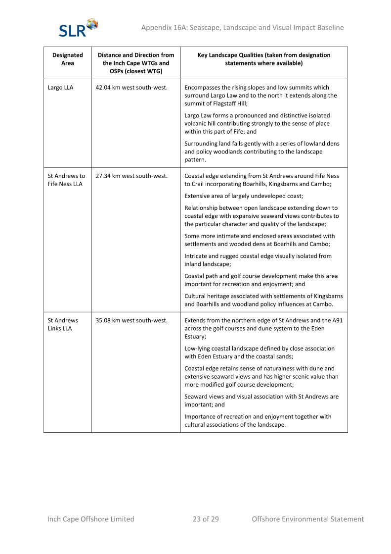
Largo LLA 42.04 km west south-west. Encompasses the rising slopes and low summits which surround Largo Law and to the north it extends along the summit of Flagstaff Hill;
Largo Law forms a pronounced and distinctive isolated volcanic hill contributing strongly to the sense of place within this part of Fife; and
Surrounding land falls gently with a series of lowland dens and policy woodlands contributing to the landscape pattern.
St Andrews to Fife Ness LLA
27.34 km west south-west. Coastal edge extending from St Andrews around Fife Ness to Crail incorporating Boarhills, Kingsbarns and Cambo;
Extensive area of largely undeveloped coast;
Relationship between open landscape extending down to coastal edge with expansive seaward views contributes to the particular character and quality of the landscape;
Some more intimate and enclosed areas associated with settlements and wooded dens at Boarhills and Cambo;
Intricate and rugged coastal edge visually isolated from inland landscape;
Coastal path and golf course development make this area important for recreation and enjoyment; and
Cultural heritage associated with settlements of Kingsbarns and Boarhills and woodland policy influences at Cambo.
St Andrews Links LLA
35.08 km west south-west. Extends from the northern edge of St Andrews and the A91 across the golf courses and dune system to the Eden Estuary;
Low-lying coastal landscape defined by close association with Eden Estuary and the coastal sands;
Coastal edge retains sense of naturalness with dune and extensive seaward views and has higher scenic value than more modified golf course development;
Seaward views and visual association with St Andrews are important; and
Importance of recreation and enjoyment together with cultural associations of the landscape.
Appendix 16A: Seascape, Landscape and Visual Impact Baseline
Inch Cape Offshore Limited 24 of 29 Offshore Environmental Statement
Designated Area
Distance and Direction from the Inch Cape WTGs and
OSPs (closest WTG)
Key Landscape Qualities (taken from designation statements where available)
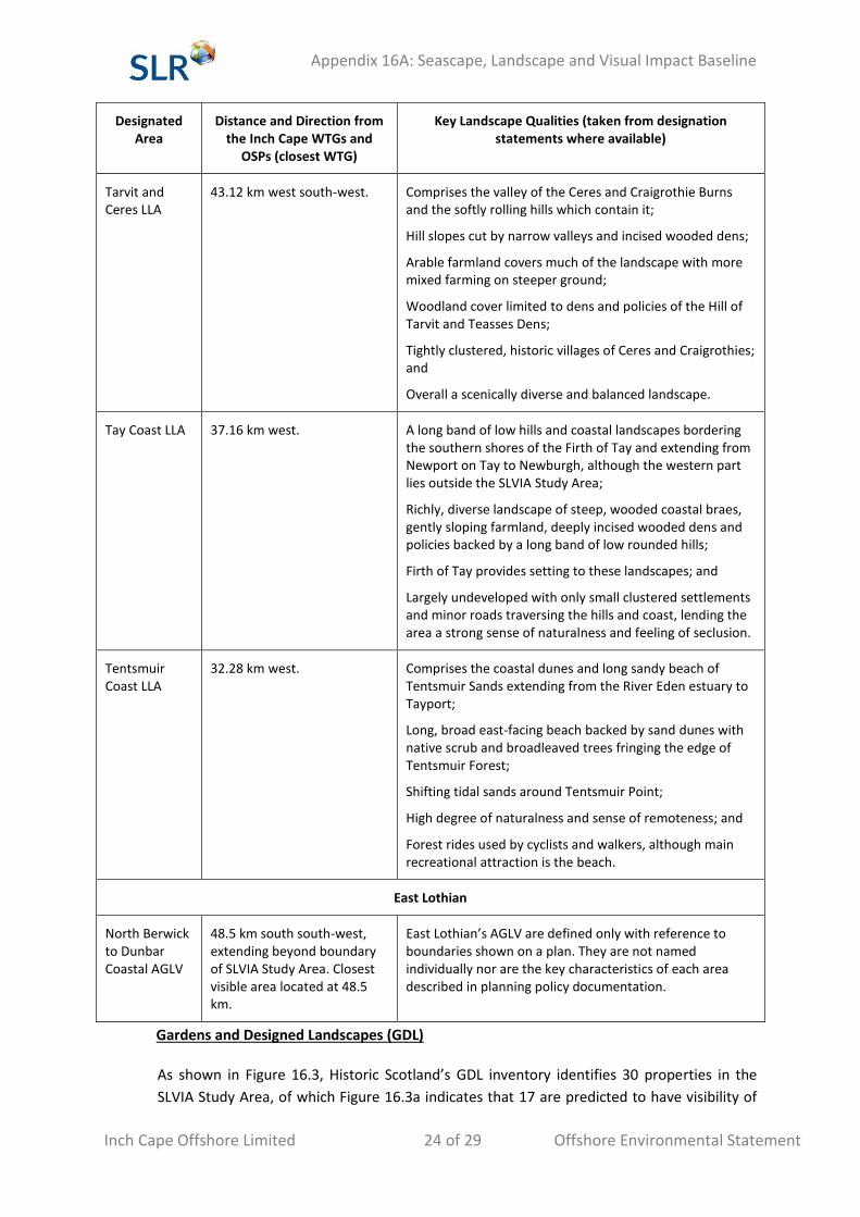
Tarvit and Ceres LLA
43.12 km west south-west. Comprises the valley of the Ceres and Craigrothie Burns and the softly rolling hills which contain it;
Hill slopes cut by narrow valleys and incised wooded dens;
Arable farmland covers much of the landscape with more mixed farming on steeper ground;
Woodland cover limited to dens and policies of the Hill of Tarvit and Teasses Dens;
Tightly clustered, historic villages of Ceres and Craigrothies; and
Overall a scenically diverse and balanced landscape.
Tay Coast LLA 37.16 km west. A long band of low hills and coastal landscapes bordering the southern shores of the Firth of Tay and extending from Newport on Tay to Newburgh, although the western part lies outside the SLVIA Study Area;
Richly, diverse landscape of steep, wooded coastal braes, gently sloping farmland, deeply incised wooded dens and policies backed by a long band of low rounded hills;
Firth of Tay provides setting to these landscapes; and
Largely undeveloped with only small clustered settlements and minor roads traversing the hills and coast, lending the area a strong sense of naturalness and feeling of seclusion.
Tentsmuir Coast LLA
32.28 km west. Comprises the coastal dunes and long sandy beach of Tentsmuir Sands extending from the River Eden estuary to Tayport;
Long, broad east-facing beach backed by sand dunes with native scrub and broadleaved trees fringing the edge of Tentsmuir Forest;
Shifting tidal sands around Tentsmuir Point;
High degree of naturalness and sense of remoteness; and
Forest rides used by cyclists and walkers, although main recreational attraction is the beach.
East Lothian
North Berwick to Dunbar Coastal AGLV
48.5 km south south-west, extending beyond boundary of SLVIA Study Area. Closest visible area located at 48.5 km.
East Lothian’s AGLV are defined only with reference to boundaries shown on a plan. They are not named individually nor are the key characteristics of each area described in planning policy documentation.
Gardens and Designed Landscapes (GDL)
As shown in Figure 16.3, Historic Scotland’s GDL inventory identifies 30 properties in the
SLVIA Study Area, of which Figure 16.3a indicates that 17 are predicted to have visibility of
Appendix 16A: Seascape, Landscape and Visual Impact Baseline
Inch Cape Offshore Limited 25 of 29 Offshore Environmental Statement
the Inch Cape WTGs and OSPs, as listed below in Table 16A.5: Gardens and Designed
Landscapes
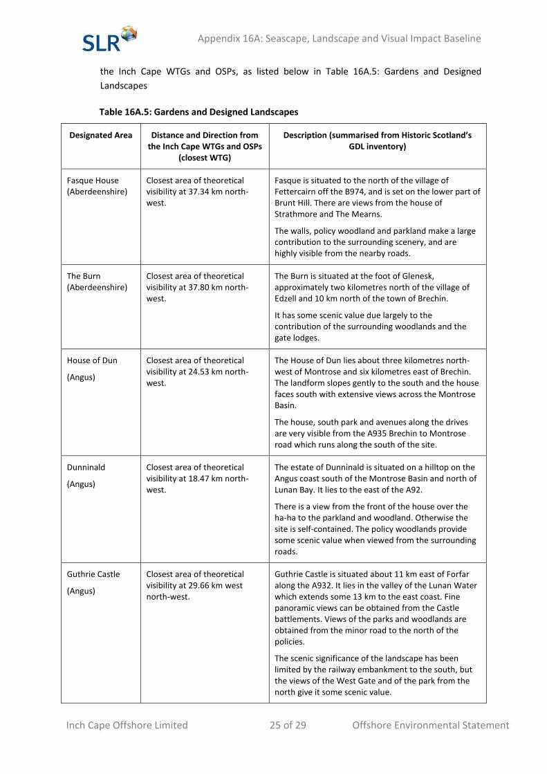
Table 16A.5: Gardens and Designed Landscapes
Designated Area Distance and Direction from the Inch Cape WTGs and OSPs
(closest WTG)
Description (summarised from Historic Scotland’s GDL inventory)
Fasque House (Aberdeenshire)
Closest area of theoretical visibility at 37.34 km north-west.
Fasque is situated to the north of the village of Fettercairn off the B974, and is set on the lower part of Brunt Hill. There are views from the house of Strathmore and The Mearns.
The walls, policy woodland and parkland make a large contribution to the surrounding scenery, and are highly visible from the nearby roads.
The Burn (Aberdeenshire)
Closest area of theoretical visibility at 37.80 km north-west.
The Burn is situated at the foot of Glenesk, approximately two kilometres north of the village of Edzell and 10 km north of the town of Brechin.
It has some scenic value due largely to the contribution of the surrounding woodlands and the gate lodges.
House of Dun
(Angus)
Closest area of theoretical visibility at 24.53 km north-west.
The House of Dun lies about three kilometres north-west of Montrose and six kilometres east of Brechin. The landform slopes gently to the south and the house faces south with extensive views across the Montrose Basin.
The house, south park and avenues along the drives are very visible from the A935 Brechin to Montrose road which runs along the south of the site.
Dunninald
(Angus)
Closest area of theoretical visibility at 18.47 km north-west.
The estate of Dunninald is situated on a hilltop on the Angus coast south of the Montrose Basin and north of Lunan Bay. It lies to the east of the A92.
There is a view from the front of the house over the ha-ha to the parkland and woodland. Otherwise the site is self-contained. The policy woodlands provide some scenic value when viewed from the surrounding roads.
Guthrie Castle
(Angus)
Closest area of theoretical visibility at 29.66 km west north-west.
Guthrie Castle is situated about 11 km east of Forfar along the A932. It lies in the valley of the Lunan Water which extends some 13 km to the east coast. Fine panoramic views can be obtained from the Castle battlements. Views of the parks and woodlands are obtained from the minor road to the north of the policies.
The scenic significance of the landscape has been limited by the railway embankment to the south, but the views of the West Gate and of the park from the north give it some scenic value.
Appendix 16A: Seascape, Landscape and Visual Impact Baseline
Inch Cape Offshore Limited 26 of 29 Offshore Environmental Statement
Designated Area Distance and Direction from the Inch Cape WTGs and OSPs
(closest WTG)
Description (summarised from Historic Scotland’s GDL inventory)
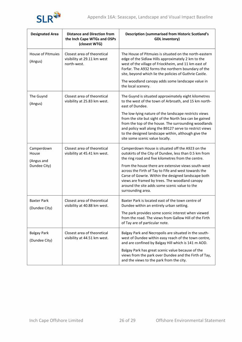
House of Pitmuies
(Angus)
Closest area of theoretical visibility at 29.11 km west north-west.
The House of Pitmuies is situated on the north-eastern edge of the Sidlaw Hills approximately 2 km to the west of the village of Friockheim, and 11 km east of Forfar. The A932 forms the northern boundary of the site, beyond which lie the policies of Guthrie Castle.
The woodland canopy adds some landscape value in the local scenery.
The Guynd
(Angus)
Closest area of theoretical visibility at 25.83 km west.
The Guynd is situated approximately eight kilometres to the west of the town of Arbroath, and 15 km north-east of Dundee.
The low-lying nature of the landscape restricts views from the site but sight of the North Sea can be gained from the top of the house. The surrounding woodlands and policy wall along the B9127 serve to restrict views to the designed landscape within, although give the site some scenic value locally.
Camperdown House
(Angus and Dundee City)
Closest area of theoretical visibility at 45.41 km west.
Camperdown House is situated off the A923 on the outskirts of the City of Dundee, less than 0.5 km from the ring road and five kilometres from the centre.
From the house there are extensive views south-west across the Firth of Tay to Fife and west towards the Carse of Gowrie. Within the designed landscape both views are framed by trees. The woodland canopy around the site adds some scenic value to the surrounding area.
Baxter Park
(Dundee City)
Closest area of theoretical visibility at 40.88 km west.
Baxter Park is located east of the town centre of Dundee within an entirely urban setting.
The park provides some scenic interest when viewed from the road. The views from Gallow Hill of the Firth of Tay are of particular note.
Balgay Park
(Dundee City)
Closest area of theoretical visibility at 44.51 km west.
Balgay Park and Necropolis are situated in the south-west of Dundee within easy reach of the town centre, and are confined by Balgay Hill which is 141 m AOD.
Balgay Park has great scenic value because of the views from the park over Dundee and the Firth of Tay, and the views to the park from the city.
Appendix 16A: Seascape, Landscape and Visual Impact Baseline
Inch Cape Offshore Limited 27 of 29 Offshore Environmental Statement
Designated Area Distance and Direction from the Inch Cape WTGs and OSPs
(closest WTG)
Description (summarised from Historic Scotland’s GDL inventory)
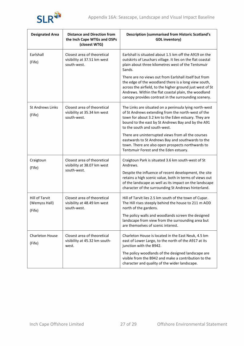
Earlshall
(Fife)
Closest area of theoretical visibility at 37.51 km west south-west.
Earlshall is situated about 1.5 km off the A919 on the outskirts of Leuchars village. It lies on the flat coastal plain about three kilometres west of the Tentsmuir Sands.
There are no views out from Earlshall itself but from the edge of the woodland there is a long view south, across the airfield, to the higher ground just west of St Andrews. Within the flat coastal plain, the woodland canopy provides contrast in the surrounding scenery.
St Andrews Links
(Fife)
Closest area of theoretical visibility at 35.34 km west south-west.
The Links are situated on a peninsula lying north-west of St Andrews extending from the north-west of the town for about 3.2 km to the Eden estuary. They are bound to the east by St Andrews Bay and by the A91 to the south and south-west.
There are uninterrupted views from all the courses eastwards to St Andrews Bay and southwards to the town. There are also open prospects northwards to Tentsmuir Forest and the Eden estuary.
Craigtoun
(Fife)
Closest area of theoretical visibility at 38.07 km west south-west.
Craigtoun Park is situated 3.6 km south-west of St Andrews.
Despite the influence of recent development, the site retains a high scenic value, both in terms of views out of the landscape as well as its impact on the landscape character of the surrounding St Andrews hinterland.
Hill of Tarvit (Wemyss Hall)
(Fife)
Closest area of theoretical visibility at 48.49 km west south-west.
Hill of Tarvit lies 2.5 km south of the town of Cupar. The Hill rises steeply behind the house to 211 m AOD north of the gardens.
The policy walls and woodlands screen the designed landscape from view from the surrounding area but are themselves of scenic interest.
Charleton House
(Fife)
Closest area of theoretical visibility at 45.32 km south-west.
Charleton House is located in the East Neuk, 4.5 km east of Lower Largo, to the north of the A917 at its junction with the B942.
The policy woodlands of the designed landscape are visible from the B942 and make a contribution to the character and quality of the wider landscape.
Appendix 16A: Seascape, Landscape and Visual Impact Baseline
Inch Cape Offshore Limited 28 of 29 Offshore Environmental Statement
Designated Area Distance and Direction from the Inch Cape WTGs and OSPs
(closest WTG)
Description (summarised from Historic Scotland’s GDL inventory)
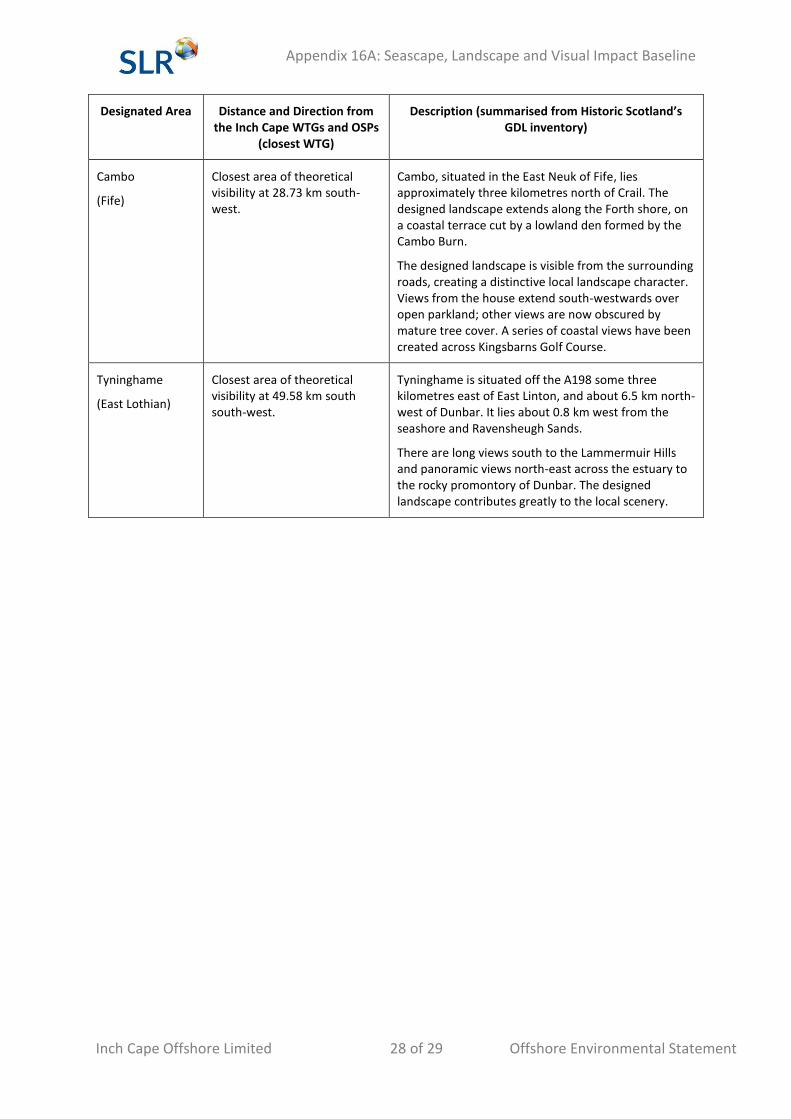
Cambo
(Fife)
Closest area of theoretical visibility at 28.73 km south-west.
Cambo, situated in the East Neuk of Fife, lies approximately three kilometres north of Crail. The designed landscape extends along the Forth shore, on a coastal terrace cut by a lowland den formed by the Cambo Burn.
The designed landscape is visible from the surrounding roads, creating a distinctive local landscape character. Views from the house extend south-westwards over open parkland; other views are now obscured by mature tree cover. A series of coastal views have been created across Kingsbarns Golf Course.
Tyninghame
(East Lothian)
Closest area of theoretical visibility at 49.58 km south south-west.
Tyninghame is situated off the A198 some three kilometres east of East Linton, and about 6.5 km north-west of Dunbar. It lies about 0.8 km west from the seashore and Ravensheugh Sands.
There are long views south to the Lammermuir Hills and panoramic views north-east across the estuary to the rocky promontory of Dunbar. The designed landscape contributes greatly to the local scenery.
Appendix 16A: Seascape, Landscape and Visual Impact Baseline
Inch Cape Offshore Limited 29 of 29 Offshore Environmental Statement
References
Angus Council (2009). Angus Local Plan Review.
Fife Council (2012). St Andrews & East Fife Local Plan. Available at:
http://publications.1fife.org.uk/uploadfiles/publications/c64_WrittenStatement.pdf
Historic Scotland(2012). The Inventory of Gardens and Designed Landscapes in Scotland. Available at:
http://www.historic-scotland.gov.uk/gardens.pdf
Scottish Natural Heritage (1998) South and Central Aberdeenshire (Review No. 102)(Environmental
Resources Management). Available at: http://www.snh.org.uk/pdfs/publications/review/102.pdf
Scottish Natural Heritage (1999a). Fife landscape character assessment (Review No. 113). Available
at: http://www.snh.org.uk/publications/on-line/LCA/fife.pdf
Scottish Natural Heritage (1999b). Tayside landscape character assessment. (Review No 122).
Available at: http://www.snh.org.uk/pdfs/publications/review/122.pdf