Lecture 20 - Princeton Universitycuff/ele301/files/lecture20.pdf · lecture12 Page 2

Oceanography 101, Richard Strickland ! ! Lecture 20 ! ! © 2006 University of Washington
What is an Estuary?
• Portion of the ocean that is semi-enclosed by land and diluted by freshwater runoff
– All estuaries are embayments
– But embayments without rivers " estuaries
• Very elastic size definition
– Small stream mouth (Pipers Creek, N. Seattle)
– Large river mouths (Columbia)
– Complex embayments (Puget Sound)
1
Oceanography 101, Richard Strickland ! ! Lecture 20 ! ! © 2006 University of Washington
Importance of Estuaries
• Biologically important
– Very productive
– Habitat for wildlife & commercial species
• Birds, mammals
•Oysters, clams, shrimp, crab
• Sole, flounder
– Nursery grounds for oceanic species
•Crab, sole, flounder, salmon, shad
– Migratory pathway for oceanic species
• Salmon, shad, striped bass
2
Oceanography 101, Richard Strickland ! ! Lecture 20 ! ! © 2006 University of Washington
Importance of Estuaries
• Economically important
– Sites for human settlement
• Sheltered harbors & access to rivers
• Fishing, recreation, & aesthetic activities
– Liquid waste disposal
•Municipal sewage
• Industrial effluent
3
Oceanography 101, Richard Strickland ! ! Lecture 20 ! ! © 2006 University of Washington
Importance of Estuaries
• Environmentally vulnerable
– Alteration of flow (dams)
– Habitat degradation & destruction
– Depletion of fish and wildlife
– Chemical contamination (“pollution”)
• Fresh/salt water boundary affects physical state and
chemical reactions of pollutants
4

Oceanography 101, Richard Strickland ! ! Lecture 20 ! ! © 2006 University of Washington
Prominent U.S. estuaries
5
• Hudson R. - Long Island Sound
• Chesapeake Bay
• San Francisco Bay
• Pamlico-Albermarle Sound
• Biscayne Bay
• Mississippi R.
Oceanography 101, Richard Strickland ! ! Lecture 20 ! ! © 2006 University of Washington
Creation of Estuaries
• Shape of estuaries related to their origin
– Broad & shallow
•Chesapeake Bay = Drowned river
valleys
– Formed by rising sea level after Ice Age
• Albermarle-Pamlico Sound = Bar-
built
– Enclosed by formation of barrier beach
6
Oceanography 101, Richard Strickland ! ! Lecture 20 ! ! © 2006 University of Washington
Creation of Estuaries
• Shape of estuaries related to their origin
– Broad & shallow
•Mississippi = river mouth
(sediment buildout)
– Narrow & deep
• San Francisco Bay = Tectonic
(San Andreas Fault)
• Puget Sound = fjord
– Carved by glaciers
7
earthobservatory.nasa.gov/Newsroom/NewImages/images.php3?img_id=9287
Oceanography 101, Richard Strickland ! ! Lecture 20 ! ! © 2006 University of Washington
Circulation in Estuaries
• 2-layered haline vertical stratification
• Surface low-salinity layer created by river runoff
• Deeper saltier layer originating from the ocean
• Separated by halocline

Oceanography 101, Richard Strickland ! ! Lecture 20 ! ! © 2006 University of Washington
Circulation in Estuaries
• Instantaneous tidal exchange (flood & ebb)
– Tidal flood & ebb at all depths at (roughly) the
same time
– Flood
– Ebb
9
Oceanography 101, Richard Strickland ! ! Lecture 20 ! ! © 2006 University of Washington
Circulation in Estuaries
• Ebb current stage
– Both surface (lower-S) & subsurface (higher-S)
layers flow seaward
– Surface layer flows faster (boost from river
input)
10
Oceanography 101, Richard Strickland ! ! Lecture 20 ! ! © 2006 University of Washington
Circulation in Estuaries
• Ebb current stage — Entrainment
– Fast surface flow causes friction across halocline
– Some turbulent mixing across halocline
– Drags some subsurface water along into outflow
11
Entrainment
Oceanography 101, Richard Strickland ! ! Lecture 20 ! ! © 2006 University of Washington
Circulation in Estuaries
• Flood current stage
– Both surface (lower-S) & subsurface (higher-S)
layers flow landward
– Surface layer flows slower (inhibition from river
input)
12
Oceanography 101, Richard Strickland ! ! Lecture 20 ! ! © 2006 University of Washington
Circulation in Estuaries
• Flood Current Stage — Tidal pumping
– Inflowing deep water hits shallow areas
– Water propelled upward into surface layer
– A form of upwelling
13
Tidal pumping
Oceanography 101, Richard Strickland ! ! Lecture 20 ! ! © 2006 University of Washington
Circulation in Estuaries
• Net circulation (mean over many tidal cycles)
– Tidal flood & ebb average almost to zero
– Surface layer: ebb is stronger than flood (rivers)
– Subsurface layer: flood is stronger than ebb
•Replace water lost to entrainment & tidal pumping
14
Oceanography 101, Richard Strickland ! ! Lecture 20 ! ! © 2006 University of Washington
• 2-layered Circulation
– Net lower-S seaward flow in surface layer
•River input
• Some entrained, pumped & mixed higher-S water
Net Circulation in Estuaries
15
Averaged over many tidal cycles — Invisible at any one moment
Oceanography 101, Richard Strickland ! ! Lecture 20 ! ! © 2006 University of Washington
• 2-layered Circulation
– Net higher-S landward flow in subsurface layer
• Inflow from ocean along bottom
•Replaces entrained, pumped & mixed higher-S
water
Net Circulation in Estuaries
16
Averaged over many tidal cycles — Invisible at any one moment

Oceanography 101, Richard Strickland ! ! Lecture 20 ! ! © 2006 University of Washington
Types of Estuaries
• 4+1 types of estuaries
– Classified by pattern of vertical stratification
– Salinity is the most important factor
•Unlike temperature dominance in most oceans
•Change in salinity between upper and lower layers
• Vertical salinity gradient is a balance
– River flow creates the stable vertical
stratification
– Mixing due to tidal action disrupts stratification.
17
Oceanography 101, Richard Strickland ! ! Lecture 20 ! ! © 2006 University of Washington
• Salinity difference #S between surface and bottom layers at any station in the estuary
– #S > ~19 g/kg = Salt Wedge or Fjord (highly
stratified)
– ~3 g/kg > #S > ~19 g/kg (PSU) = Partially
Mixed (moderately stratified)
– #S < ~3 g/kg = Well Mixed (weakly stratified or
unstratified)
Classification of Estuaries I
18
Oceanography 101, Richard Strickland ! ! Lecture 20 ! ! © 2006 University of Washington
• Based on ratio of mean volume of river inflow (R) to mean volume of tidal prism (P) over 1 (mean) tidal cycle
– R/P > 1 = Salt Wedge or Fjord (highly
stratified)
– R/P ~0.25 = Partially Mixed (moderately
stratified)
– R/P <0.1 = Well Mixed (weakly stratified or
unstratified)
Classification of Estuaries II
19
Oceanography 101, Richard Strickland ! ! Lecture 20 ! ! © 2006 University of Washington
Salt wedge estuaries
• Dominated by high river runoff
– Large river mouths
•Columbia & Mississippi
– Smaller river mouths entering larger estuaries
•Duwamish entering Puget Sound
– Named for sharp boundary between river &
sea water
• Strong halocline moves back and forth with tides
• Strong vertical stratification
20
Oceanography 101, Richard Strickland ! ! Lecture 20 ! ! © 2006 University of Washington
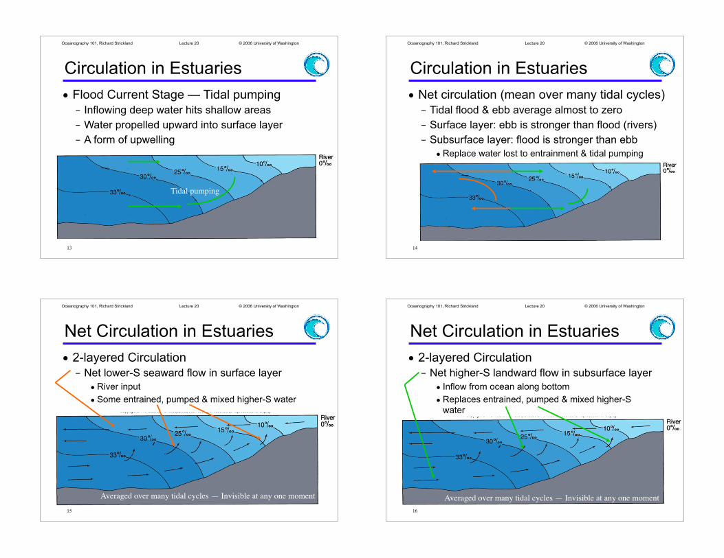
Salt wedge estuaries
• Dominated by high river runoff
– Weak vertical mixing, strong stratification
– Strong halocline “wedge” moves with tide
•Moves up river channel for some distance on flood
•Moves out into open water on flood
– Weak entrainment of higher-S water
21
Oceanography 101, Richard Strickland ! ! Lecture 20 ! ! © 2006 University of Washington
Salt wedge estuaries
• Columbia River estuary
– Strong halocline “wedge” moves with tide
•Moves up river channel for some distance on flood
•Moves out into open water on ebb
22
www.ccalmr.ogi.edu/CORIE/
Oceanography 101, Richard Strickland ! ! Lecture 20 ! ! © 2006 University of Washington
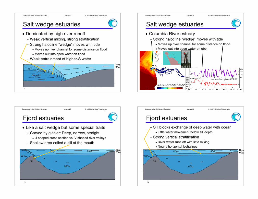
Fjord estuaries
• Like a salt wedge but some special traits
– Carved by glacier: Deep, narrow, straight
•U-shaped cross section vs. V-shaped river valleys
– Shallow area called a sill at the mouth
23
Oceanography 101, Richard Strickland ! ! Lecture 20 ! ! © 2006 University of Washington
Fjord estuaries
– Sill blocks exchange of deep water with ocean
• Little water movement below sill depth
– Strong vertical stratification
•River water runs off with little mixing
•Nearly horizontal isohalines
24
Oceanography 101, Richard Strickland ! ! Lecture 20 ! ! © 2006 University of Washington
Fjord estuaries
• Found in B.C., S.E. Alaska, Chile, Norway, Scotland, New Zealand
– Puget Sound has fjord-
like properties
•Carved by a glacier
– But one moving from mouth to head
• Several sills
– Mixing strong enough that the deep water is replaced
– Potential for oxygen depletion in places
25
Oceanography 101, Richard Strickland ! ! Lecture 20 ! ! © 2006 University of Washington
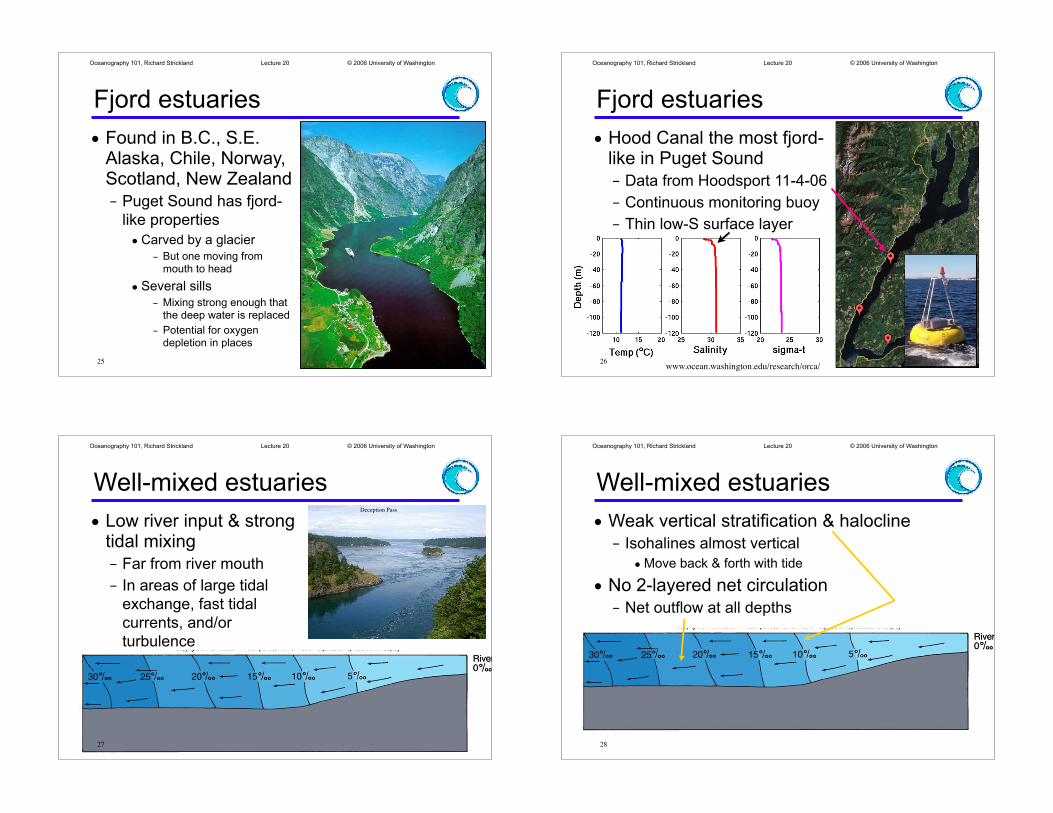
Fjord estuaries
• Hood Canal the most fjord-like in Puget Sound
– Data from Hoodsport 11-4-06
– Continuous monitoring buoy
– Thin low-S surface layer
26www.ocean.washington.edu/research/orca/
Oceanography 101, Richard Strickland ! ! Lecture 20 ! ! © 2006 University of Washington
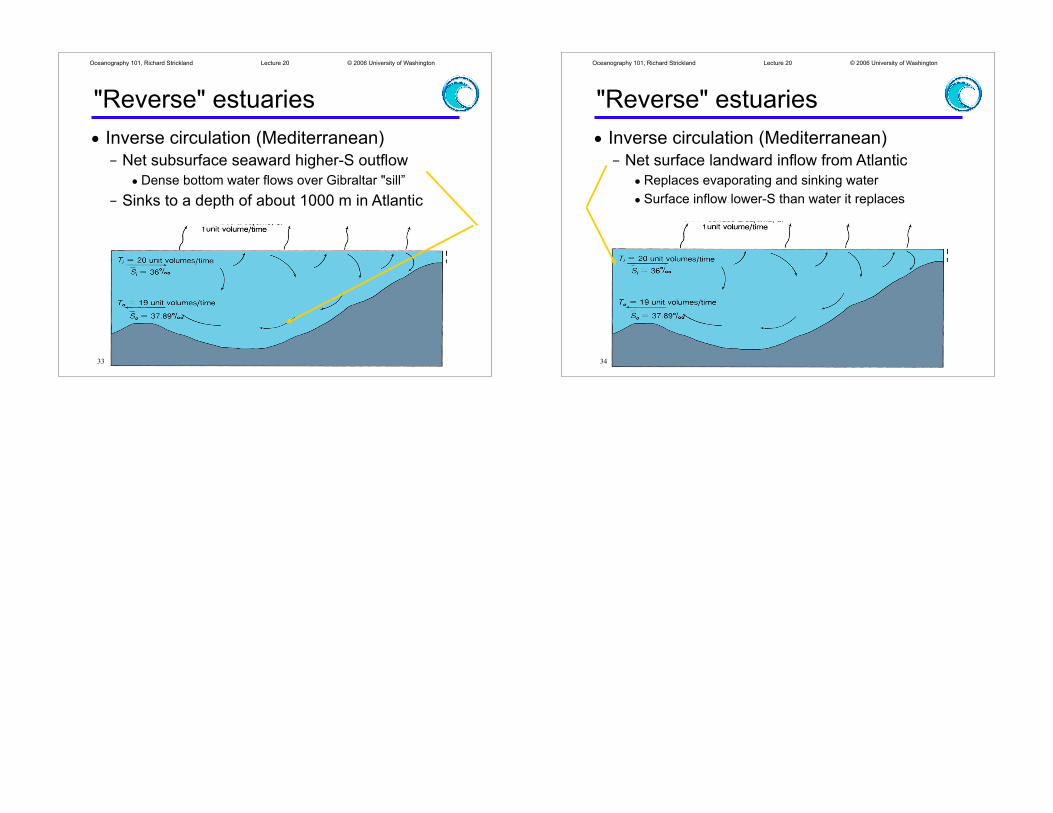
Well-mixed estuaries
• Low river input & strong tidal mixing
– Far from river mouth
– In areas of large tidal
exchange, fast tidal
currents, and/or
turbulence
Deception Pass
27
Oceanography 101, Richard Strickland ! ! Lecture 20 ! ! © 2006 University of Washington
Well-mixed estuaries
• Weak vertical stratification & halocline
– Isohalines almost vertical
•Move back & forth with tide
• No 2-layered net circulation
– Net outflow at all depths
28

Oceanography 101, Richard Strickland ! ! Lecture 20 ! ! © 2006 University of Washington
29
• Currents in inland passages
– Large volume of water
squeezing into a narrow
shallow channel
• Admiralty Inlet
• Tacoma Narrows
– Speed of current & rough
bottom topography
• Strong vertical mixing
• Breaks down stratification
Well-mixed estuaries
Oceanography 101, Richard Strickland ! ! Lecture 20 ! ! © 2006 University of Washington
Partially-mixed estuaries
• Rough balance between rivers & mixing
– 2 layers & 2-layered circulation
•Halocline weaker & broader than salt wedge or fjord
•Mixing, entrainment, tidal pumping stronger
• Example: Puget Sound Main Basin off Seattle area
30
Oceanography 101, Richard Strickland ! ! Lecture 20 ! ! © 2006 University of Washington
Partially-mixed estuaries
• Halocline weaker & broader than salt wedge or fjord
– UW ORCA buoy moored off Edmonds
•Data from Nov. 7 2004
•More gradual change in S with depth
www.ocean.washington.edu/research/orca/31
Oceanography 101, Richard Strickland ! ! Lecture 20 ! ! © 2006 University of Washington
"Reverse" estuaries
• Not really estuaries
– Semi-enclosed
evaporative basins
• Arid, subtropical latitudes
• Fresh water gain from
rivers much less than loss
to evaporation
•Mediterranean & Red Seas
• Vertically instability & convection
– Evaporation increases surface salinity
– Surface water more dense despite temperature
32
Oceanography 101, Richard Strickland ! ! Lecture 20 ! ! © 2006 University of Washington
"Reverse" estuaries
• Inverse circulation (Mediterranean)
– Net subsurface seaward higher-S outflow
•Dense bottom water flows over Gibraltar "sill”
– Sinks to a depth of about 1000 m in Atlantic
33
Oceanography 101, Richard Strickland ! ! Lecture 20 ! ! © 2006 University of Washington
"Reverse" estuaries
• Inverse circulation (Mediterranean)
– Net surface landward inflow from Atlantic
•Replaces evaporating and sinking water
• Surface inflow lower-S than water it replaces
34


![[PPT]PowerPoint Presentation - Hypersensitivitymcb.berkeley.edu/.../Lecture20/Lecture20_files/Lecture20.ppt · Web viewHypersensitivity Robert Beatty MCB150 TYPE I Hypersensitivity](https://static.fdocuments.in/doc/165x107/5aa9eb4b7f8b9a7c188d726c/pptpowerpoint-presentation-viewhypersensitivity-robert-beatty-mcb150-type-i.jpg)