Implication of Drainage Basin Parameters of Kukrail Nala ...
9
1 Implication of Drainage Basin Parameters of Kukrail Nala, Ganga Plain, using Remote Sensing and GIS techniques Dhirendra Kumar 1 , Dhruv Sen Singh 2 & Manisha Mishra 3 Abstract Kukrail Nala is forth order tributary of Gomati River. The drainage characteristic of the basin have been delineated with the help of topographical maps (1:50,000) provided by Survey of India. All the basic work such as digitization, slope map preparation and stastical calculation has been done with the help of Geographical Information System (Arc GIS 10). The slope map of the basin is prepared by SRTM data of LANDSAT. The total area of the Kukrail Nala basin is 86.75 km2 and first order streams are mostly dominating the basin. The mean Rb of the entire basin is 4.36, indicates that the drainage pattern is not much influenced by geological structures. The analyses indicate that basin has gentle slope gradient, low surface run-off, low sediment production, high infiltration rate, low water storage capacity and low value of basin relief. These parameters provide useful information for the prediction of basin behavior during prolonged heavy rainfall and suggest that water resource management and developmental planning should be done with reference to the drainage basin parameters. © 2014 GSS Journals. All rights reserved. Keywords 1. Introduction The Ganga Plain is one of the vast, most fertile and densely populated regions in the world. It formed after the continental- continental collision of Indian plate and Asian plate (Dewey and Bird 1970) and contains the quaternary alluvium. The length of the Ganga Plain is about 1000 km and the width ranges from 200-450 km. The Ganga plain exhibits various geomorphic surfaces such as Upland Terrace Surface, Marginal Plain Upland Surface, Megafan Surfaces, River Valley Terrace Surface, Piedmont Fan Surfaces, and Active Flood Plain Surfaces on regional scale (Singh, 1996). These geomorphic surfaces exhibit an abandoned channel, ponds, lakes and point bar deposits of palaeo-channels. Ganga Plain drained by 1 Centre of Advanced Study in Geology University of Lucknow, Lucknow–226 007, India, Email: [email protected] 2 Centre of Advanced Study in Geology University of Lucknow, Lucknow–226 007, India, Email: [email protected] 3 Remote Sensing Applications Centre, Uttar Pradesh, Lucknow-226021, India, Email: [email protected] (Corresponding author) : Drainage Morphometry, SOI Toposheet (1:50000), GIS & Satellite Imageries.
Transcript of Implication of Drainage Basin Parameters of Kukrail Nala ...

1
Implication of Drainage Basin Parameters of Kukrail Nala, Ganga Plain, using Remote Sensing and GIS
techniques
Dhirendra Kumar1, Dhruv Sen Singh2 & Manisha Mishra 3
Abstract
Kukrail Nala is forth order tributary of Gomati River. The drainage characteristic of the basin have been delineated with the help of topographical maps (1:50,000) provided by Survey of India. All the basic work such as digitization, slope map preparation and stastical calculation has been done with the help of Geographical Information System (Arc GIS 10). The slope map of the basin is prepared by SRTM data of LANDSAT. The total area of the Kukrail Nala basin is 86.75 km2 and first order streams are mostly dominating the basin. The mean Rb of the entire basin is 4.36, indicates that the drainage pattern is not much influenced by geological structures. The analyses indicate that basin has gentle slope gradient, low surface run-off, low sediment production, high infiltration rate, low water storage capacity and low value of basin relief. These parameters provide useful information for the prediction of basin behavior during prolonged heavy rainfall and suggest that water resource management and developmental planning should be done with reference to the drainage basin parameters.
© 2014 GSS Journals. All rights reserved.
Keywords
1. Introduction The Ganga Plain is one of the vast, most fertile and densely populated regions in the world. It formed after the continental-continental collision of Indian plate and Asian plate (Dewey and Bird 1970) and contains the quaternary alluvium. The length of the Ganga Plain is about 1000 km and the width ranges from 200-450 km. The Ganga
plain exhibits various geomorphic surfaces such as Upland Terrace Surface, Marginal Plain Upland Surface, Megafan Surfaces, River Valley Terrace Surface, Piedmont Fan Surfaces, and Active Flood Plain Surfaces on regional scale (Singh, 1996). These geomorphic surfaces exhibit an abandoned channel, ponds, lakes and point bar deposits of palaeo-channels. Ganga Plain drained by
1 Centre of Advanced Study in Geology University of Lucknow, Lucknow–226 007, India, Email:
[email protected] 2 Centre of Advanced Study in Geology University of Lucknow, Lucknow–226 007, India, Email:
[email protected] 3 Remote Sensing Applications Centre, Uttar Pradesh, Lucknow-226021, India, Email:
[email protected] (Corresponding author)
: Drainage Morphometry, SOI Toposheet (1:50000), GIS & Satellite Imageries.
Implication of Drainage Basin…
2
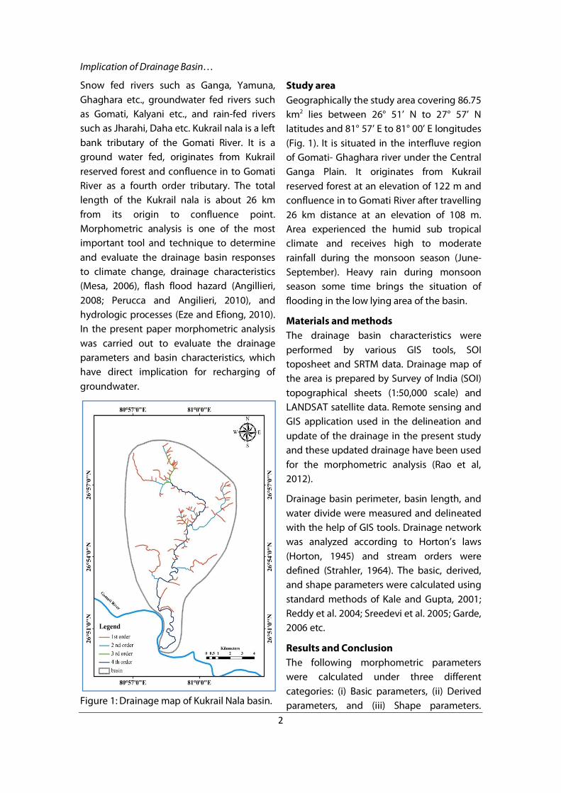
Snow fed rivers such as Ganga, Yamuna, Ghaghara etc., groundwater fed rivers such as Gomati, Kalyani etc., and rain-fed rivers such as Jharahi, Daha etc. Kukrail nala is a left bank tributary of the Gomati River. It is a ground water fed, originates from Kukrail reserved forest and confluence in to Gomati River as a fourth order tributary. The total length of the Kukrail nala is about 26 km from its origin to confluence point. Morphometric analysis is one of the most important tool and technique to determine and evaluate the drainage basin responses to climate change, drainage characteristics (Mesa, 2006), flash flood hazard (Angillieri, 2008; Perucca and Angilieri, 2010), and hydrologic processes (Eze and Efiong, 2010). In the present paper morphometric analysis was carried out to evaluate the drainage parameters and basin characteristics, which have direct implication for recharging of groundwater.
Figure 1: Drainage map of Kukrail Nala basin.
Study area Geographically the study area covering 86.75 km2 lies between 26° 51’ N to 27° 57’ N latitudes and 81° 57’ E to 81° 00’ E longitudes (Fig. 1). It is situated in the interfluve region of Gomati- Ghaghara river under the Central Ganga Plain. It originates from Kukrail reserved forest at an elevation of 122 m and confluence in to Gomati River after travelling 26 km distance at an elevation of 108 m. Area experienced the humid sub tropical climate and receives high to moderate rainfall during the monsoon season (June- September). Heavy rain during monsoon season some time brings the situation of flooding in the low lying area of the basin.
Materials and methods The drainage basin characteristics were performed by various GIS tools, SOI toposheet and SRTM data. Drainage map of the area is prepared by Survey of India (SOI) topographical sheets (1:50,000 scale) and LANDSAT satellite data. Remote sensing and GIS application used in the delineation and update of the drainage in the present study and these updated drainage have been used for the morphometric analysis (Rao et al, 2012).
Drainage basin perimeter, basin length, and water divide were measured and delineated with the help of GIS tools. Drainage network was analyzed according to Horton’s laws (Horton, 1945) and stream orders were defined (Strahler, 1964). The basic, derived, and shape parameters were calculated using standard methods of Kale and Gupta, 2001; Reddy et al. 2004; Sreedevi et al. 2005; Garde, 2006 etc.
Results and Conclusion The following morphometric parameters were calculated under three different categories: (i) Basic parameters, (ii) Derived parameters, and (iii) Shape parameters.

Dhirendra Kumar et al.
3
These parameters provide information regarding the basin characteristics.
Basic Parameters Kukrail nala basin occupies an area about 86.75 km2 and perimeter of the basin is 49.46 km. Maximum length of the basin from origin to the confluence (end point) of the river (L) is 16.76 km. The maximum and minimum height of the basin is 122 m (msl) and 108 m (msl) respectively. The total numbers of first, second, and third order tributaries are 77, 14 and 3 respectively. The total length of first, second, third and fourth order streams are 40.55 km, 12 km, 04 km and 23 km respectively. The total numbers of streams of all order are 95 covering the total length of 79.55 km. The geometric relationship between log values of stream number (Nu) to stream order and stream length (Lu) to stream order of the Kukrail nala basin is shown in figure 2.
Figure 2: Graph between stream number (Log Nu), stream length (Log Lu) and Stream order
Stream order (Nu): In the present study, ranking of streams has been carried out based on the method proposed by Strahler (1964). It is obvious that the total number of streams gradually decreases as the stream order increases with the application of GIS, the number of streams of each order and the total number of streams were computed and observed that the maximum number of stream was in lower order. Drainage patterns of the basin are dendritic type which indicates the homogeneity in texture and lack of structural control.
Figure 3: Slope map.
Stream length (Lu): The stream length (Lu) is a dimensional property used to understand the characteristic size of the components of a drainage network. It reflects the hydrological characteristics of the underlying rock surfaces over the areas of consecutive stream
Implication of Drainage Basin…
4
orders. A smaller number of relatively longer stream lengths are formed, where the rock formations are permeable, while a larger number of smaller stream lengths are developed, where the rock formations are less permeable (Pakhmode et al. 2003). The stream lengths basins of various orders have been measured on topographical maps.
Slope (Sb) Slope analysis is an important parameter in geomorphic studies. Slope map of any particular area/region provides data for planning, settlement, mechanization of agriculture, deforestation, planning of engineering structures, morphoconservation practices etc. (Sreedevi et al. 2005. Lithology, climate and tectonics of any region directly influence the slope of that particular region. In the study area slope map was prepared on SRTM data (Fig. 3).
Derived Parameters Derived parameters are generated from basic parameters such as, basin relief (R), relief-ratio (Rr), bifurcation ratio (Rb), stream-length ratio (Rl), RHO coefficient (RHO), stream frequency (Fs), drainage density (Dd), drainage texture (T), and length of overland flow (Lg).
Basin Relief (R) Basin relief is the difference in elevation between the highest (H) and lowest point (h) of the basin. According to Hadley and Schumm (1961):
R= H-h
Kukrail nala basin has low 14 m basin relief (R) indicates low run-off, low sediment transport, and spreading of water within the basin.
Relief-Ratio (Rr) Relief-ratio (Rr) is a dimensionless parameter. It is the ratio between basin relief (R) and basin length (L) (Schumm, 1963) and is
directly proportional to the surface run-off and intensity of erosion.
Rh = H / Lb Where, Rh = Relief Ratio, H = Total relief (Relative relief) of the basin in Kilometers. Lb = Basin length. The relief-ratio (Rr) of Kukrail nala basin is 0.83 which indicates low to medium surface run-off and low stream power for erosion
Bifurcation Ratio (Rb) It is the ratio between number of streams of any given order (Nu) to the number of streams in the next higher order (Nu+1) (Horton, 1945) and reflects the degree of ramification of drainage network. Bifurcation ratio varies from 3-5 for natural drainage system. It is 4.36 for this basin, which falls in the normal range (3-5). It shows that the drainages are natural and not much influenced by geological structures.
Rb= Nu/Nu+1 Where, Rb = Bifurcation Ratio, Nu = Total no. of stream segments of order ‘u’. Nu + 1 = Number of segments of the next higher order.
Stream-length Ratio (Rl) According to Horton’s law (1945) of stream length states that mean stream length segments of each of the successive orders of a basin tends to approximate a direct geometric series with streams length increasing towards higher order of streams. The RL values between streams of different order in the both the sub-watersheds reveals that there are variations in slope and topography. It is 2.12 for this basin.
RL= Lu/Lu-1 Where, RL = Stream Length Ratio, Lu = Total stream length of the order ‘u’, Lu – 1 = Total stream length of its next lower order.
RHO Coefficient (RHO) It is the ratio of Rl (stream length ratio) and Rb (bifurcation ratio) and represents
Dhirendra Kumar et al.
5
relationship between drainage density and physiographic development of the basin (Horton, 1945). It also evaluates the water storage capacity of the basin. Higher values indicate high and low values indicate low capacity for the storage of water. The value of RHO Coefficient is 0.48, which indicate low capacity for the storage of water.
Stream Frequency (Fs) Horton (1932) introduced stream frequency (Fs) and defined as stream frequency which is the total number of stream segments of all orders per unit area. It is measure of the permeability of surface lithology, vegetation, and relief. It is 1.09 km-2 for this basin which indicate moderate permeable alluvium and low relief. It also indicates extremely poor stream frequency.
Fs= ∑Nu/A
Where, Fs = Stream Frequency, Nu = Total no. of streams of all orders. A = Area of the Basin (sq km).
Drainage Density (Dd) Drainage density (Dd) is the total length of stream per unit area of drainage basin. Low value of ‘Dd’ indicates highly permeable region (Horton, 1945). It is 0.80 for this basin and reflects permeable and erodible alluvium. It is mainly influenced by the resistance of the bed material to erosion, and capacity of infiltration.
Dd= Lu/A
Where, Dd = Drainage Density, Lu = Total stream length of all orders. A = Area of the Basin (sq km).
Drainage Texture (T) It is the relative channel spacing in a fluvial dissected terrain and depends upon a number of natural factors such as climate, rainfall, vegetation, rock/ soil type, rate of infiltration, relief and evolutionary stage of the basin (Kale and Gupta, 2001). On the
other hand, the T is a product of Dd (Drainage Density) and Fs (Stream Frequency). It is calculated by multiplying drainage density with stream frequency. The T is classified as coarse drainage texture if it is less than 4; intermediate drainage texture, if it is between 4 and 10; fine drainage texture, if it ranges from 10 to 15; and ultra-fine drainage texture, if it is more than 15 (Smith 1950).
T= Dd*Fs
The basin drainage texture is 0.87(km-1), which clearly indicates the coarse drainage texture. According to Dornkamp and King (1971), the T of the rocks depends upon the type of vegetation and the climate.
Form Factor (Rf) The form factor (Rf) may be defined, as the ratio of basin area to square of the watershed length (Horton 1932). The Form Factor (Ff) is defined as the ratio of the basin area to the square of the basin length. It is 0.30 for this basin.
Rf = A / Lb² Where, Rf = Form Factor,A = Area of the watershed (sq km). Lb² = Square of watershed length.
Shape Parameters Shape parameters such as elongation ratio (Re), and circularity index (Rc) indicate shape characteristics of the basin (Table 1).
Elongation Ratio (Re) Schumm (1956) defined elongation ratio (Re) as the ratio between the diameter of the circle of the same area as the drainage basin and the maximum length of the basin. The elongation ratio (Re) value 0.62 indicates the elongated shape of the basin.
Re = 2 v (A / π) / Lb Where, Re = Elongation Ratio, A = Area of the Basin (sq km), π = ‘Pi’ value i.e., 3.14, Lb = Basin length.
Implication of Drainage Basin…
6
Circularity Index (Rc) The Circularity index (Rc) is expressed as the ratio of basin area (A) and area of a circle with the same perimeter as that of the basin (P). Unit circularity index (Rc) shows circular shape of basin and indicate uniform infiltration with long time for surplus water to reach the outlet or confluence which further depends on geology, slope, and land cover (Reddy et al. 2004). The Circularity index (Rc) value (0.44) indicates elongated shape, mature topography and support dendritic pattern of drainage network. According to Strahler (1964):
Rc= 4πA/p2 Where, Rc = basin circularity, p = basin perimeter, A = area of the basin and 4 is a constant.
Length of Overland flows (Lg) The length of overland flow (Lg) is one of the most important independent variables, affecting both the hydrological and physiographical development of the drainage basins. The Length of Overland Flows (Lg) of the Kukrail nala basin is 0.62.
The length of overland flow (Lg) approximately equals to half of the reciprocal of drainage density (Horton, 1945).
Lg = 1 / D * 2 Where, Lg = Length of Overland flow, D = Drainage Density.
Elipticity index (E) Elipticity index (E) of the basin is 2.54
Constant of Stream Maintenance (C) Schumm (1956) used the inverse of drainage density as a property termed constant of stream maintenance C.
C = 1/ D Where, D = Drainage Density and C is Constant of Stream Maintenance.
The Constant of Stream Maintenance (C) of the Kukrail nala basin is 1.25. Specifically, the constant C provides information of the number of square feet of watershed surface required to sustain one linear foot of stream. The constant of channel maintenance indicates the relative size of landform units in a drainage basin and has a specific genetic connotation (Strahler, 1957).
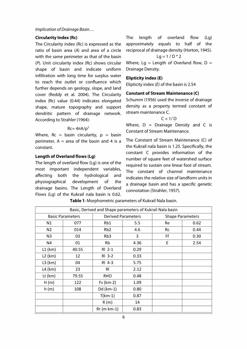
Table 1: Morphometric parameters of Kukrail Nala basin.
Basic, Derived and Shape parameters of Kukrail Nala basin Basic Parameters Derived Parameters Shape Parameters
N1 077 Rb1 5.5 Re 0.62 N2 014 Rb2 4.6 Rc 0.44 N3 03 Rb3 3 Ff 0.30 N4 01 Rb 4.36 E 2.54
L1 (km) 40.55 Rl 2-1 0.29 L2 (km) 12 Rl 3-2 0.33 L3 (km) 04 Rl 4-3 5.75 L4 (km) 23 Rl 2.12 Lt (km) 79.55 RHO 0.48 H (m) 122 Fs (km-2) 1.09 h (m) 108 Dd (km-1) 0.80
T(km-1) 0.87 R (m) 14 Rr (m km-1) 0.83
Dhirendra Kumar et al.
7
Conclusions Kukrail nala is a fourth order river basin with dominance of lower order stream, which is elongated in NS direction. The basin has gentle slope, low surface relief, low surface run-off, high infiltration rate, and low water storage capacity which indicates mature stage of topographic evolution and erosion and so reworks the preexisting sediments of
the Ganga Plain. This groundwater fed alluvial stream originating in the middle Ganga Plain region has natural drainage system. The morphometric parameters have hydrological significance. The analysis provides information that recharging of the groundwater is a natural process in this basin therefore planning for water resource management should be made to retain it.
References
Angilliri YE (2008) Morphometric analysis of Colanguil river basin and flash flood hazard, San Jaun, Argentina. Environ. Geol., v. 55 (1), pp. 107-111, DOI: 10.1007/s00254-007-0969-2.
Awasthi A. and Singh DS (2011) Shallow Subsurface Facies of Chhoti Gandak River Basin, Ganga Plain, India. In: DS Singh and NL Chhabra (Eds.), Geological Processes and Climate Change. Macmillan Publishers India Ltd., pp.223-234.
Bhardwaj V and Singh DS (2011) Surface and Ground Water Quality Characterization of Deoria District, Ganga Plain, India. Environ. Earth Sci., v.63, pp.383-395.
Bhardwaj V, Singh DS and Singh AK (2010 a) Water Quality of the Chhoti Gandak River using Principal Component Analysis, Ganga Plain, India. Jour. Earth. Sys. Sci., v.119(1), pp.117-127.
Bhardwaj V, Singh DS and Singh AK (2010 b) Environmental repercussions of cane-sugar industries on the Chhoti Gandak river basin, Ganga Plain, India. Environ. Mon. Asses., v.171,
Dewey JF and Bird JM (1970) Mountain belts and new global tectonics, Journal of Geophysical Research, v. 40, pp. 695-707.
Dickinson WR (1974) Plate tectonics and sedimentation, p. 127. In: Tectonic and sedimentation, (Ed. Dickinson WR), Spec. Publ 22: SEPM, Tulsa, Okla.
Dornkamp JC and King CAM (1971) Numerical analyses in geomorphology: an introduction. St Martins, New York, pp. 372.
Eze EB and Efiong J (2010) Morphometric Parameters of the Calabar River Basin: Implication for Hydrologic Processes. Jour. Geogr. Geol., v.2 (1), pp.18-26.
Garde RJ (2006) River Morphology. New Age International (P) Ltd. Publ., pp.11-31.
Hadely RF and Schumm SA (1961) Sediment sources and drainage basin characteristics in upper Cheyenne River basin. United State Geological Survey water-supply paper, v. 1531-B, pp. 137-196.
Horton RE (1932) Drainage basin characteristics. Trans Am Geophys Union, v. 13, pp. 350–361.
Implication of Drainage Basin…
8
Horton RE (1945) Erosional development of streams and their drainage basins: hydrophysical approach to quantitative morphology. Bull. Geol. Soc. Am., v. 56, pp. 275-370.
Kale VS and Gupta A (2001) Introduction to geomorphology. New Delhi: Academic (India) Publishers (Chapter 3).
Mesa LM (2006) Morphometric analysis of a subtropical Andean basin (Tucumam,Argentina). Environmental Geology, v. 50(8), pp. 1235-1242.
Pakhmode V, Kulkarni H and Deolankar SB (2003) Hydrological drainage analysis in watershed programme planning: a case from the Deccan Basalt India. Hydrogeol J, v. 11, pp. 595–604.
Perucca LP and Angilieri YE (2010) Morphometric characterization of del Molle Basin applied to the evolution of flash floods hazards, Iglesia Department, San Jaun, Argentina. Quarternary Internat., doi: 10.1016/j.quaint. 2010.08.007.
Rao GT, Rao VVSG, Dakate R., Rao STM and Rao BMR (2012) Remote Sensing and GIS based Comparative Morphometric Study of Two Sub-watershed of Different Physiographic Conditions, West Godavari District, A.P., J. Geological Society of India, v.79, pp.383-390.
Reddy GPO, Maji AK and Gajbhiye KS (2004) Drainage morphometry and its influence on landform characteristics in a basaltic terrain, Central India – a remote sensing and GIS approach. International Journal of Applied Earth Observation and Geoinformation, v. 6, pp. 1–16.
Schumm SA (1956) The evolution of drainage systems and slopes in bad lands at Perth Amboy, New Jersey. Geol. Soc. Amer. Bull. v. 67, pp. 597-646.
Schumm SA (1963) Sinuosity of alluvial rivers on the Great Plains. Geol. Soc. Am. Bull. v. 74, pp. 1089–1100.
Singh DS and Singh IB (2005) Facies architecture of the Gandak Megafan, Ganga Plain, India. Special Publication of the Palaeontological Society of India, No. 2, 125-140.
Singh DS (2007) Flood mitigation in the Ganga Plain. In: N. Rai and A.K. Singh (Ed.), Disaster Management in India, New Royal Book Company, pp.167-179.
Singh DS and Awasthi A (2009) Impact of Landuse and Landscape Change on Environment. Urban Panorama, v.VIII (2), pp.72-78.
Singh DS, Awasthi A and Bhardwaj V (2009) Control of Tectonics and Climate on Chhoti Gandak River Basin , East Ganga Plain, India. Himalyan Geology, Vol. 30 (2), 2009, pp.147-154.
Singh DS and Awasthi A 2011(A) Natural hazards in the Ghaghara River area, Ganga, Plain, India, Natural Hazards, 57:213–225, DOI 10.1007/s11069-010-9605-7.
Singh DS and Awasthi A 2011(b) Implication of Drainage Basin Parameters of Chhoti Gandak River, Ganga Plain, India, Journal of the Geological Society of India. Vol.78, pp.370-378.
Singh DS, Awasthi A and Nishat (2010) Impact of Climate Change on the Rivers of Ganga Plain. Inter. Jour. Rur. Devel. Manag. Studies, v.4 (1), pp.1-8.

Dhirendra Kumar et al.
9
Singh DS, Kumar S, Kumar D, Nishat, Awasthi A and Bhardwaj V (2013) Sedimentology and channel pattern of the Chhoti Gandak River, Ganga Plain, India. Gond. Geol. Mag., V.28(2), pp171-180.
Singh DS, Prajapati SK, Singh P, Singh K and Kumar D (2015) Climatically induced levee break and flood risk management of the Gorakhpur region, Rapti River Basin, Ganga Plain, India. Journal Geological Society of India 85, 79e86.
Singh DS, Gupta AK, Sangode SJ, Clemens SC, Prakasam M, Srivastava P and Prajapati SK (2015) Multiproxy record of monsoon variability from the Ganga Plain during 400-1200 A.D. Quaternary International xxx, pp. 1-7
Singh IB (1996) Geological evolution of Ganga Plain – an overview. Journal of the Palaeontological Society of India, v. 41, pp. 99–137.
Smith KG (1950) Standards for grading texture of erosional topography. Am J Sci., v. 248, pp. 655- 688.
Sreedevi PD, Subrahmanyam K and Shakeel A (2005) The significance of morphometric analysis for obtaining groundwater potential zones in a structurally controlled terrain. Environmental Geology, v. 47(3), pp. 412-420.
Srivastava P, Singh IB, Sharma M and Singhvi AK (2003) Luminescence chronometry and Late Quaternary geomorphic history of the Ganga Plains, India. Palaeogeography, Paleoclimatology, Palaeoecology, v. 197, pp. 15–41.
Strahler AN (1957) Quantitative analysis of watershed geomorphology. Trans Am Geophys Union, v. 38, pp. 913–920.
Strahler AN (1964) Quantitative geomorphology of drainage basin and channel networks. In: V.T. Chow (Ed.) Handbook of applied hydrology. McGraw Hill Book Co., New York, pp.4-76.