Implication of Contestation for Urban Space on Streets: a ...
160
i IMPLICATION OF CONTESTATION FOR URBAN SPACE ON STREETS: A Case of Mwihoko Street, Githurai - Kiambu County ADELBERT MORIANGO B.A. Geography (Hons) - Moi University A Research Project Submitted in Partial Fulfilment of the Requirement for the award of a Master of Arts Degree in Planning University of Nairobi June, 2017
Transcript of Implication of Contestation for Urban Space on Streets: a ...
i
IMPLICATION OF CONTESTATION FOR URBAN SPACE ON STREETS: A Case of Mwihoko Street, Githurai - Kiambu County
ADELBERT MORIANGO
B.A. Geography (Hons) - Moi University
A Research Project Submitted in Partial Fulfilment of the Requirement for the award of a Master
of Arts Degree in Planning
University of Nairobi
June, 2017

ii
DECLARATION
Candidate
This research project is my original work and to the best of my knowledge has not been previously
presented in this or any other University for an award of a degree or any other purposes.
Signed………………………… Date………………………………
Moriango Adelbert
B63/68851/2013
(Candidate)
Supervisor
This research project makes part of the requirement for the award of a Master of Arts degree in
Planning, University of Nairobi.
Signed…………………………… Date……………………………..
Omwenga Mairura
(Supervisor)

iii
DEDICATION
I dedicate this project to my family

iv
ACKNOWLEDGEMENTS
I would like to thank my employer - Ministry of Lands and Physical Planning, for providing me
with the opportunity of pursuing this course. I’m also grateful to my workmates in the Ministry
for their continued advice and support.
I would like also to acknowledge the input provided by my supervisor Mr. Omwenga Mairura,
lecturers; Dr Fridah Mugo, Dr Musyimi Mbathi, Course coordinator Dr Romanus Opiyo, Dr Isaac
Mwangi (Chairman DURP) and all staff at DURP. I thank them greatly for their guidance and
supervision in the process of coming up with this report.
I want to acknowledge my classmates for their continued support and contribution throughout the
period I was carrying out this research project.
I also want to acknowledge all respondents who diligently took their time to fill the questionnaires
without asking anything in return. And finally, I thank the authors whose material I referred to.

v
ABSTRACT Urban streets are places that play a pivotal role of making urban life more enjoyable and lively.
When not well planned, they become dysfunctional. Mwihoko Street has become an attractive
place for all kinds of traffic that is viewed as a potential market by those in the informal sector.
This has led to an influx of informal activities onto the streets, and in so doing, have affected the
smooth functioning of the street. The main aim of the research was to assess the implications of
urban street space use contestation by informal activities. While the subsidiary aim of the research
was to propose better planning approaches that can mitigate/mediate the space contestation. The
study was guided by a number of objectives, and it employed a non-experimental research method
carried out under phases: preliminary, data collection, data analysis & finally, conclusion and
recommendation. The research established that the study area has attracted many informal
activities that contest for space use, and include: encroachments from commercial buildings; street
vendors; on street parking, and pedestrians, boda bodas, and motorists competing for space on the
roadway. All these have led to: reduced street size, traffic jams, street users contest to use the
carriageway, blocked storm drains and loss of business on the part of formal enterprises. The study
proposes various intervention measures to be put in place. At policy level, the study proposes: the
national government to formulate Flexible Change of User Laws that are not cumbersome, to
enable private investors provide extra spaces for traders; street vendors should advocate for a
progressive National Policy on Street Vending – what is in existence is not being felt on the ground
(they should advocate for youth & women funds to target vendors); another recommendation is
for street designers to adopt negotiated and collaborative approaches in street design – by
incorporating street users while designing urban streets and also to embrace collaborative
approaches whereby the design has to take a multidisciplinary design processes; and lastly,
advocate the county governments to implement the Urban Areas and Cities Act, 2011 which
requires the setting up of Town Management Committees for Urban Areas and Cities so as to bring
services closer to people. At site level, the study proposes: the Preparation of an urban
Development Plan for the town; upgrading Githurai to a service centre with the following
components – a modern storey market, paving of back streets & back lanes, paving the roundabout,
provision of proper drainage and street lighting; modernisation of the street to segregate users with
provision of spaces for street vendors; and lastly, the study proposes the construction of two wide
Non-motorized Flyovers to link Githurai 44 and Githurai 45.

vi
TABLE OF CONTENTS DECLARATION ........................................................................................................................ ii
DEDICATION .......................................................................................................................... iii
ACKNOWLEDGEMENTS ........................................................................................................ iv
ABSTRACT ................................................................................................................................ v
List of Figures ........................................................................................................................... ix
List of Maps ................................................................................................................................ x
List of Tables .............................................................................................................................. x
List of Plates ............................................................................................................................... x
CHAPTER 1: INTRODUCTION .............................................................................................. 1
1-1 Introduction and Background to the Problem ............................................................................... 1
1-2 Problem Statement ........................................................................................................................ 3
1-3 Research Aims, Questions and Objectives.................................................................................... 5
1-3.1 Research Aims ...................................................................................................................... 5
1-3.2 Research Questions ............................................................................................................... 5
1-3.3 Research Objectives .............................................................................................................. 5
1-4 Justification and Significance of the Study ................................................................................... 6
1-5 Assumption and Limitations of the Study ..................................................................................... 7
CHAPTER 2: LITERATURE REVIEW ................................................................................... 8
2-1 Introduction ................................................................................................................................... 8
2-2 Definitional and Conceptual Issues ............................................................................................... 8
2-2.2 The Concept of the Street ...................................................................................................... 8
2-2.3 Streets Functions ................................................................................................................... 9
2-2.4 Street Zones & Design Elements ........................................................................................ 12
2-2.5 Scheme Street Designs ........................................................................................................ 12
2-2.6 Historical Perspectives of Streets ........................................................................................ 15
2-2.7 Theories of Urban Design ................................................................................................... 17
2-3 Street as an Emerging Space for Contestation ............................................................................ 18
2-3.2 Public Space and Informal Activity .................................................................................... 18
2-3.3 Factors that Influence Space Use Contestation ................................................................... 21
2-4 Planning and Development Implications of Space Use Contestation ......................................... 25
2-4.1 Informal Activities on Urban Streets .................................................................................. 26
2-5 Legitimacy of Street Vending ..................................................................................................... 30
2-5.1 The Reformist School of Thought ...................................................................................... 30
2-5.2 The Marxist school of thought ............................................................................................ 31
2-5.3 Health and Environmental Issues around Street Vending ................................................... 32
2-5.4 The Gender Perspective ...................................................................................................... 33
vii
2-5.5 Lessons Drawn in the Legitimacy of Street Vending ......................................................... 33
2-6 Innovative Planning Approaches to incorporate Urban Street Vendors: Case Studies ............... 35
2-6.1 Case Studies from Asia ....................................................................................................... 35
2-6.2 Development of National Policies ...................................................................................... 39
2-6.3 Private Sector Involvement ................................................................................................. 40
2-6.4 Integrated Approaches to Support Street Vendors .............................................................. 42
2-6.5 Licensing and Infrastructural Support ................................................................................. 43
2-7 Lessons Learnt from Literature Review ...................................................................................... 44
2-8 Conceptual Framework ............................................................................................................... 48
CHAPTER 3: RESEARCH METHODOLOGY ...................................................................... 50
3-1 Introduction ................................................................................................................................. 50
3-2 Research Design .......................................................................................................................... 50
3-3 Research Population & Sampling Procedures............................................................................. 52
3-3.1 Sampling Frame .................................................................................................................. 52
3-3.2 Sample Size ......................................................................................................................... 52
3-3.3 Sampling Procedure ............................................................................................................ 55
3-4 Data Needs, Sources and Methods of Data Collection ............................................................... 56
3-4.1 Secondary Data Collection .................................................................................................. 57
3-4.2 Primary Data Collection ...................................................................................................... 57
3-5 Techniques of Data Analysis and Presentation ........................................................................... 59
CHAPTER 4: SITUATIONAL ANALYSIS OF MWIHOKO STREET ................................. 61
4-1 Introduction ................................................................................................................................. 61
4-1.1 Historical Background of Githurai Market Centre: Pre – 1963 to 2000 ............................. 61
4-1.2 Development Trends of Githurai market Centre: From 200 to the Present ........................ 61
4-2 Geographical Location ................................................................................................................ 63
4-3 Physical and Geological features ................................................................................................ 68
4-3.1 Topography ......................................................................................................................... 68
4-3.2 Geology and Soils ............................................................................................................... 68
4-3.3 Hydrology ........................................................................................................................... 68
4-3.4 Vegetation ........................................................................................................................... 69
4-4 Climatic Characteristics .............................................................................................................. 69
4-5 Demographic Characteristics ...................................................................................................... 71
4-6 Socio-Economic Characteristics ................................................................................................. 73
4-7 Social Infrastructure .................................................................................................................... 73
4-7.1 Education Facilities ............................................................................................................. 73
4-7.2 Health Facilities .................................................................................................................. 74

viii
4-7.3 Recreation Facilities ............................................................................................................ 74
4-8 Physical Infrastructure ................................................................................................................ 75
4-8.1 Road and Railway Transport ............................................................................................... 75
4-8.2 Water and Sewerage ............................................................................................................ 75
4-8.3 Solid Waste System ............................................................................................................ 76
4-9 Legal Framework Guiding Street Functionality ......................................................................... 76
4-9.1 Kenya Constitution, 2010 ................................................................................................... 76
4-9.2 Traffic Act, 2012 ................................................................................................................. 77
4-9.3 Urban Areas and Cities Act, 2011....................................................................................... 77
4-9.4 County Government Act, 2012 ........................................................................................... 77
4-9.5 Way -Leave Act (Cap 292) ................................................................................................. 78
4-9.6 Environmental Management and Coordination Act, 1999.................................................. 79
4-9.7 National Transport and Safety Authority Act (NTSA), 2012 ............................................. 79
4-10 Policy Framework Guiding Street Functionality ........................................................................ 80
4-10.1 Vision 2030, Kenya............................................................................................................. 80
4-10.2 Integrated National Transport Policy (2012) ...................................................................... 81
4-10.3 The National Urban Development Policy (2012) ............................................................... 82
4-10.4 Physical Planning Handbook .............................................................................................. 83
4-11 Conclusion .................................................................................................................................. 84
CHAPTER 5: SPACE USE CONTESTATION ON MWIHOKO STREET ........................... 85
5-1 Introduction ................................................................................................................................. 85
5-2 Major Activities Located Along Mwihoko Street ....................................................................... 85
5-2.1 Activity Types ..................................................................................................................... 85
5-2.2 Building Form and Line in the Study Area ......................................................................... 88
5-2.3 Places and Nature of Contestation ...................................................................................... 89
5-2.4 Mwihoko Street Design ...................................................................................................... 92
5-2.5 Traffic Experience in the Study Area.................................................................................. 93
5-2.6 Land Uses along Mwihoko street ........................................................................................ 94
5-3 Factors that Influence Space use Contestation a long Mwihoko Street ...................................... 98
5-3.1 Respondents’ Social- Economic Characteristics ................................................................. 98
5-3.3 Serves as the Main Artery – Contest for Space by Many Modes of Transport ................. 102
5-3.4 Context of Space between Economic & Transportation Land Use ................................... 103
5-3.5 Invasion by Informal Economic Entrepreneurs ................................................................ 104
5-3.6 Degraded Working Environment ...................................................................................... 104
5-4 Planning and Development Implications of Street Space Contestation .................................... 105
5-4.1 Traffic Jams ...................................................................................................................... 106

ix
5-4.2 Experiences a lot of Traffic ............................................................................................... 106
5-4.3 Reduced Street Size - unclear demarcation of economic & transportation land uses ....... 106
5-4.5 Blocked Storm Drains ....................................................................................................... 108
5-4.6 Loss of Business on the Part of Formal Enterprises ......................................................... 109
5-5 Proposed Policy, Spatial Planning and Design Interventions ................................................... 109
5-5.1 Upgrade the Street to Dual Carriage ................................................................................. 110
5-5.2 Provision of Non-Motorized Transport (NMT) ................................................................ 110
5-5.3 Construction of a Bus Terminus ....................................................................................... 110
5-5.4 Removal of Street Vendors ............................................................................................... 110
5-5.5 Improve Working Environment ........................................................................................ 111
5-5.6 Provision of Traffic Police Officers .................................................................................. 111
5-5.7 Response from Key Informants ........................................................................................ 112
CHAPTER 6: MEDIATING STREET SPACE USE CONTESTATION .............................. 114
6-1 Nil Intervention ......................................................................................................................... 114
6-2 Upgrading and Rehabilitation option ........................................................................................ 114
6-3 Declaration of Githurai as a Special Planning Area and Preparation of a LPDP ...................... 116
6-4 Sectoral Policy: Preparation of an Integrated Urban Transport Plan ........................................ 116
6-5 Sectoral Policy on Street Vending ............................................................................................ 121
6-6 Redevelopment Approach: Integrating Market and a Terminal Facility .................................. 123
6-7 Collaborative Approach in Review of Street Designs .............................................................. 126
6-8 Integrated Approach .................................................................................................................. 126
CHAPTER 7: SYNTHESIS, CONCLUSION & RECOMMENDATIONS ........................... 127
7-1 Introduction ............................................................................................................................... 127
7-2 Synthesis of the Findings .......................................................................................................... 127
7-2.1 Planning for Alternative Streets to Access Thika Superhighway ..................................... 127
7-2.2 Planning for Open Air Markets & Terminal facilities ...................................................... 127
7-2.3 Citizen Participation in the Review of Street Designs, & Proposal for a Pro-Active Street
Vendor Associations ......................................................................................................................... 128
7-2.4 Designing for Diversity ..................................................................................................... 128
7-3 Conclusion ................................................................................................................................ 129
7-4 Recommendations ..................................................................................................................... 130
7-5 Areas for Further Research ....................................................................................................... 131
BIBLIOGRAPHY .................................................................................................................. 132
APPENDICES ........................................................................................................................ 137
List of Figures Figure 2. 1: Street Intersection Zone with respective dimensions ............................................................. 14
Figure 2. 2: The Natural Market – Proposed Schematic Solution .............................................................. 37

x
Figure 2. 3: Conceptual Framework ........................................................................................................... 48
Figure 3. 1: Research Methodology Flow chart .......................................................................................... 51
Figure 5. 1: Sample design street cross section........................................................................................... 92
Figure 5. 2: Street Cross Section ................................................................................................................. 97
Figure 5. 3: Marital Status .......................................................................................................................... 98
Figure 5. 4: Respondents' Residency Distance in Km from the Study Area ............................................... 99
Figure 5. 5: Occupation of Pedestrians ....................................................................................................... 99
Figure 5. 6: Education Level ..................................................................................................................... 100
Figure 5. 7: Ages of Street Vendors .......................................................................................................... 100
Figure 5. 8: Causes of Problems Experienced .......................................................................................... 101
Figure 5. 9: Times of Occurrence of Space Contest ................................................................................. 102
Figure 5. 10: Challenges faced by Street Vendors .................................................................................... 107
Figure 6. 1: Design Example of a modern street ....................................................................................... 117
Figure 6. 2: Proposed Typical Modernized street Cross Section .............................................................. 119
Figure 6. 3: Proposed Street Modernization ............................................................................................. 119
List of Maps Map 4. 1: National Context of Kiambu County .......................................................................................... 64
Map 4. 2: Regional Context of Mwihoko Street in Kiambu County .......................................................... 65
Map 4. 3: Urban Context of Mwihoko Street in Ruiru Sub-County ........................................................... 66
Map 4. 4: Detailed Neighbourhood Context of Mwihoko Street ................................................................ 67
Map 5. 1: Nature and Places of Space Contestation ................................................................................... 91
Map 5. 2: Land Use along the study area .................................................................................................... 95
Map 5. 3: Inter-Dependency that Exist between Various Land Use Sites .................................................. 96
Map 6. 1: Proposals to relieve pressure from Mwihoko Street ................................................................. 120
Map 6. 2: Suitable sites for Bus terminus and Storey Market .................................................................. 125
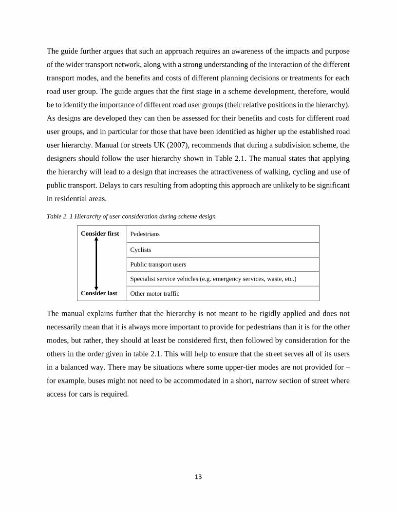
List of Tables Table 2. 1 Hierarchy of user consideration during scheme design ............................................................. 13
Table 3. 1: Sample frame table ................................................................................................................... 55
Table 3. 2: Data needs matrix ..................................................................................................................... 60
List of Plates
Plate 2. 1: Informal Activities on Urban Streets - Street Vending in India................................................. 27
Plate 2. 2: Problems Facing Street Vendors ................................................................................................ 28
Plate 2. 3: Problems Street Vendors cause other street users ...................................................................... 28
Plate 2. 4: Image of Quthing Showing Encroachments and “Pinch” Points ............................................... 29
Plate 2. 5: Imagery of Quthing .................................................................................................................... 29
Plate 2. 6: Extraction from the imagery of the urban centre ....................................................................... 30
Plate 2. 8: Market along the road next to APMC ........................................................................................ 36

xi
Plate 2. 7: Wasted space, with potential for trading .................................................................................... 36
Plate 2. 9: The new platforms - not yet in use ............................................................................................. 36
Plate 2. 10: Trading from the ground - before improvement ...................................................................... 36
Plate 2. 11: Vegetable Market at Saiyadpura .............................................................................................. 37
Plate 2. 12: Bhatar Market - Fixed stalls on raised platform ...................................................................... 38
Plate 2. 13: Time-sharing of space – with Temporary shade ...................................................................... 39
Plate 2. 14: Pedestrianised Street on Sunday ............................................................................................. 39
Plate 2. 15 Rotterdam Market Hall in Netherlands ..................................................................................... 41
Plate 2. 16: Durban's Warwick Junction ..................................................................................................... 43
Plate 2. 17: Street Vendors in Dar es Salaam ............................................................................................. 44
Plate 5. 1: Commercial building ................................................................................................................. 86
Plate 5. 2: Small scale retailers along the street .......................................................................................... 87
Plate 5. 3: Tomato wholesale site................................................................................................................ 87
Plate 5. 5: Users contesting for space ......................................................................................................... 87
Plate 5. 4: Pedestrians using the carriageway ............................................................................................. 87
Plate 5. 6: Building Form in the study area ................................................................................................. 88
Plate 5. 7: Un-designated Bus Terminus ..................................................................................................... 90
Plate 5. 8: Vendors on the carriageway ..................................................................................................... 104
Plate 5. 9: Blocked Storm Drains .............................................................................................................. 108
Plate 5. 10: Activities along the Street ...................................................................................................... 109
Plate 5. 11: Image of a well paved back lane used by vendors ................................................................. 111
Plate 6. 1: New Kongowea market in Mombasa ....................................................................................... 115
Plate 6. 2: An indoor Market in San Juan de Dios in Guadalajara ............................................................ 115
Plate 6. 3: Barriers used to delineate between pedestrian and vehicle zone ............................................. 118
Plate 6. 4: Kind of stalls that can be put up along the street ..................................................................... 122
Plate 6. 5: Vendor stalls facing adjacent shops ......................................................................................... 122
Plate 6. 6: Good example of curb side cafés providing access to all ........................................................ 123
Plate 6. 7: Example of how the underpass can be improved ..................................................................... 124
GLOSSARY OF ACRONYMS & ABBREVIATIONS
CABE Commission for Architecture and the Built Environment, UK
CBO Community Based Organizations
DETR Department for Environment, Transport and the Regions
GIS Geographical Information Systems
KNBS Kenya National Bureau of Statistics
NMT Non-Motorized Transport

xii
SACCOs Savings and Credit Cooperative Organizations
SPSS Statistical Package for Social Scientists
UIDP Urban Integrated Development Plan
WIEGO Women in Informal Employment: Globalizing and Organizing
WILL Concept of: Work, Invest, Live, and have Leisure
1
CHAPTER 1: INTRODUCTION
1-1 Introduction and Background to the Problem
Human settlement takes place on a defined ‘space’ that should be ordered and planned for proper
functioning. Stout (2008), argue that the concept of space has taken on increased importance in
the practice of planning as officials attempt to order and re-image communities in an effort to
attract and retain private investment. He further argues that expert place making practices are often
at odds with the informal ways in which local users contribute to the meaning of space.
Schneekloth & Shibley (2000), argue that space, both as a concept and a discrete place on earth,
is a contested terrain. They further argue that contested space use may be defined to include sites
of conflict where people or ideals collide resulting in a scramble for a place by each individual,
owners and a number of land uses within the situation. They further argues that contestation for
space may refer to locations where existing land uses contest for accommodation, and all struggle
for control of these spaces. Spaces contested may include: forest reserves, riparian zones,
undeveloped lands, open spaces, streets, and generally public land.
Space contestation has been accelerated by Urbanization that is taking place in 3rd world countries
at an alarming rate. UN-Habitat (2015), puts the urban population in Kenya at 25.6% of the total
population, while the annual Rate of urbanization is 4.34%. Panwar and Garg (2015) argue that
poverty and lack of gainful employment in the rural areas and in small towns, drive large numbers
of people to the cities for work and livelihood. These people generally possess low skills and lack
the level of education required for the better paid jobs in the organized sector. Besides, permanent
protected jobs in the organized sector are shrinking hence even those having the requisite skills
are unable to find proper employment (Bhowmik and Saha, 2012). The high population require
places to live, invest, work and have leisure (unpublished urban studio notes, 2015). Bhowmik
(2012) argue that there are few formal job opportunities that can accommodate these large
population. The excess population that cannot be absorbed into the formal economy, ends up in
the informal sector being their only means for their survival. The informal sector has not been
taken seriously by the planning fraternity. And therefore, it is not accommodated in Development
Plans of our towns. Those who join the informal sector, tend to occupy spaces set aside as
commons – (in most cases, streets), where you find all kinds of informalities contesting for space
use (Brown, 2008).
2
A well-functioning street should be one that is segregated with the presence of: sidewalks, cyclist
paths, and free traffic flow that provides transport for goods and passengers to various destinations.
It connects factors of production – making the whole process cheaper. It also influences land
values, and rents tend to be higher for investors (Michael et al. 2003). The street is usually
attractive to the informal sector activities since it is used by all kinds of people in different ways
including: driving through, walking through as pedestrian, and others pass through as customers
of goods on display. All these become potential customers for the informal sector activities. And
as such, those in the informal sector struggle to occupy vantage spaces along the street, from where
their goods can attract many customers (Skinner, 2008).
The informal sector consists of those activities characterized by ease of entry into the activity
concerned: reliance on indigenous resources, family ownership of enterprises, small scale of
operations, labour intensive and adaptive technology, and skills acquired outside the formal school
system and unregulated and competitive markets (ILO, 1972). Davy (2009), argue that, while
entrepreneurs gain the right to use office space or shops from private property or rental agreements,
the self-employed poor often use their homes or the commons for business purposes (street
vendors). The unemployed poor also often miss out on services that are typically associated with
a workplace (like internet access). Kim (2015), argue that in large cities around the world, the most
competed for public space is the streets and accompanying sidewalks. As a result of historic
migration and immigration to urban centres, the spatial projects vying for this space have
multiplied. In particular, the growth of street vending causes us to reconsider some of the
fundamental concepts that we have used to understand the city. Vending can be seen as a private
taking over public space. It can contribute to civic vitality, as well as be an impediment to traffic
flow. Vendors are often micro-entrepreneurs who cannot access the private real estate market as
spaces for livelihood. The issues about the legitimate use of public space, the right to the city, and
local ordinance enforcement/dereliction are often complicated by class conflict as well as the street
vendors’ diverse ethnic and their migrant/immigrant status (Kim, 2015).
Davy (2009), argue that the street falls under “the contested spaces of urban commons”. He goes
further to state that, “the spatiality of poverty and wealth is grounded in plural perceptions of land
and the social production of land uses by the wealthy and the poor. Although most spatial planners
position themselves as promoters of social and ecological issues, they often neglect the relationship

3
between the poor and the land”. Allison Brown in her book titled “Claiming Rights to the Streets”,
argues that public space can and should be considered a common property resource from which
the urban poor can generate a livelihood (ibid). Davy, (2009), argue that since many of those who
encroach the street are the poor, who cannot afford to own a piece of land within the urban Centre,
then the commons are essential for their land use practices, even if the roadside offers little comfort
to them. The activities that contest for space use on streets, take many forms, including: the selling
of goods - whether from individual kiosks or more expansive markets; small businesses such as
cafes, ‘mama mbogas’ (vegetable vendors), apparels, fruits vendors, vehicle repair shops;
uncontrolled stops by buses, Matatus (Passenger vehicles), taxis, ‘boda bodas’ (motor cyclists who
ferry passengers); all other informal public transport, and other unregulated parking often
associated with business activities on the road reserve; there is also uncontrolled development in
the built environment whereby structures are put up so close to the road without observing the
building codes.
Added to this list of activities are social activities associated with the roadside which are far from
being illegal. In rural areas, in particular, but also in urban areas and at entrances to towns and
villages, the roadside provides a social venue. People congregate along streets to talk, smoke, and
drink or watch the traffic. The encroachment of all these activities into the street, interferes with
the efficiency of the street in question and ends up creating challenges in mobility. Rodrigue,
(2013), states that efficient transportation reduces costs, while inefficient transportation increases
costs. Therefore, areas with good streets, influences land values whereby land prices and even rent
tend to be higher. This is the case, since movement of goods and services is efficient and those
who reside in such areas are prepared to pay more. This research is designed to assess the
Implications of Urban Street Space Use Contestation by Informal Activities along Mwihoko Street
in Githurai, with a view to formulate sustainable land use planning proposals that will
accommodate such informal sector activities for harmonious co-existence, and development of the
area.
1-2 Problem Statement
Githurai market Centre is urbanizing at a very fast rate due to its proximity to Thika superhighway,
and also, the large population residing at the Centre given that it’s a dormitory for those working
in Nairobi city. Currently, there exists a large open air market that is serving traders from as far as

4
Tanzania who bring in their produce for sale to retailers. The retailers transport the produce to
neighbouring estates. While the majority of traders are based in Githurai, where they display their
wares in the open air market (which cannot accommodate all), the rest display their goods along
the streets. Mwihoko Street is the main distributor road for many estates in the hinterland of
Githurai. It is the only tarmacked road in Githurai urban Centre, and thus all the traffic is directed
there. This Street has so many vehicles for both personal and for passengers. It also serves a big
pedestrian populace who come to the Centre for various transactions or travelling to and from the
bus terminus en-route to or from work places. The high population along this Street has attracted
street vendors who scramble for the little space along the Street, and even on sections of the tarmac;
and therefore, rising tension with other street users.
The function of the street of being a place to do business, has taken much space to the detriment
of the other functions. This has been due to many people viewing the street as a place to eke out a
livelihood. Many of those who have encroached the street space, are informal sector activities, the
majority being street vendors. Brown, et al. (2014), states that today, modern street vending plays
a vital role in the urban economy, as a source of jobs, revenue and ‘value added’ to the economy.
Street vending provides a flexible link in economic supply chains, gives vitality to urban streets,
and provides affordable goods for many urban residents. Yet street vending exacerbates congestion
at busy sites e.g. city centres where the facilities have not been provided to accommodate them.
These informal activities are set to increase given the high population increase. The informal
activities were never envisaged in the initial plan for Githurai which had set aside a small area for
an open air market. Much of the land in the area is private, and mostly under residential and
commercial use. Most of the building structures are dilapidated, thus requires renewal. The main
challenges include: Impediment of street mobility function, lack of traffic segregation, informal
activities carried on the street: street vendors, boda bodas, Matatus, cyclists, cart pushers, timber
yards etc. all these have led to, congestion, accidents, and insecurity being witnessed in the study
area.
There are a number of financial institutions that are operating in Githurai Centre e.g. Coop bank,
Family bank, Equity bank, Post bank etc. Many supermarkets have also been set up e.g. KassMart,
Nairobi Mart, Naivas and other small ones. All these serve residents of Githurai and surrounding
estates e.g. K.U, Kahawa Sukari, Kahawa Wendani, Zimmerman, Kasarani, Mwihoko, Kwa
5
Mumbi, Kizito etc. This means the population catchment area for Githurai centre is large and
therefore the centre needs some reorganization in terms of infrastructure development for efficient
provision of the required services. Given the fact that the institutional framework has been rigid
and has been ineffective in solving problems of contestation for space use along Mwihoko street,
there is need for immediate intervention that will ensure re-organisation of space a long this street
(space for commons) to accommodate compatible land uses, and separate incompatible land uses,
segregate users, and also propose mixed land use in the adjacent plots.
1-3 Research Aims, Questions and Objectives
1-3.1 Research Aims
The main aim of the research is to assess the implications of urban street space use contestation by
informal activities. A subsidiary aim of the research is to propose better planning approaches that
can mitigate/mediate the space contestation.
1-3.2 Research Questions
This research raises a number of research questions, the main ones being:-
1. What are the major activities located along Mwihoko Street, Githurai?
2. What factors have influenced their location?
3. What are the planning and development implications?
4. How can better planning approaches be proposed for mitigating and mediating the street
space use contestation by informal activities in urban areas?
1-3.3 Research Objectives
The specific objectives of the research are:-
1. To investigate and map major activities located along Mwihoko street in Githurai
2. To examine the factors influencing space use contestation along Mwihoko Street
3. To examine the planning and development implications of street space use contestation along
Mwihoko street
4. To propose better planning approaches for mitigating and mediating space use contestation
along Mwihoko Street.

6
1-4 Justification and Significance of the Study
Since Mwihoko Street is the main artery street in Githurai, if the current situation is left unchecked,
it may become impassable and accidents may escalate, leading to the situation reaching critical
levels and therefore, bringing Githurai to a standstill. Hence, the study on implications of urban
street space use contestation by informal activities along Mwihoko Street, will come up with the
right spatial, institutional, as well as identify policies, which will bring harmony, efficient mobility,
and integrate informal sector activities contesting for space use, thus accommodating even the
lowly in society, in our urban setup. Hence, this study is very significant in understanding how
such activities can be integrated into the urban system. This project is best suited to be undertaken
by the urban planning discipline given the fact that this is where things to do with space use are
best dealt with. Under the discipline, compatible land uses are put next to one another, while
incompatible land uses are separated from one another by being designated in different areas.
Given the fact that the problem at hand is that of having incompatible land uses next to one another,
the discipline of planning will come in handy to solve most of these problems in the study area.
Many studies done on informal sector activities have concentrated on how governments should
provide more space to this sector, but have not brought in the element of integrating this sector
into our urban system by involving private investors in space provision. The study intends to bring
out involvement of private investors in space provision, and show that urban planning should
incorporate other disciplines (urban road design included) in the process of bringing order to our
urban centres.
The outcome of the study will be significant to various beneficiaries in that: by re-designing
Mwihoko Street so that users are segregated, the tension experienced in the study area at the
moment, will reduce tremendously. The study intends to come up with alternative sites for
informal traders and propose innovative ways in which more space can be created from the
prevailing environment. This will go a long way in reducing the tension that usually exist between
those operating from adjacent buildings and the informal traders who block their business
premises. The study will also be significant to urban planners in that for a long time they have not
given great attention to informal sector activities which have become a norm in our urban centres.
It will show how extra spaces can be created in our urban system so as to integrate such activities.
At policy level, the study aims to propose that it will be mandatory, while designing urban streets,
urban designers should come up with Wide Streets designs with enough space to accommodate

7
different users, and at the same time accommodate traders at selected sites without interfering with
other users.
In summary, this study on activities competing for space on our urban streets is very significant in
understanding how such activities can be integrated into the urban system during planning. It will
go a long way to show how the same approach can be replicated in other towns, since many of our
urban centres have been affected with the menace of informal activities competing for the small
public spaces set aside for other land uses. It is through the implementation of the proposed
intervention and recommendation of this study, that the benefits of integration will be achieved.
Thus, this study will add knowledge about integrating informal activities in our urban system given
that it is a reality that can no longer be ignored for the proper functioning of our towns.
1-5 Assumption and Limitations of the Study
The research setting on space use contestation is limited by the geographical scope of the study
area, which covers Mwihoko Street - a stretch of 300 metres from the junction with Thika
Superhighway, within a distance of 200 metres on either side of the street. An assumption taken
by this study is that the findings, results, outcomes and recommendations can be validated and
generalized for any urban street experiencing similar challenges. This study is limited to space use
contestation on urban streets. An assumption taken by this study is that the outcomes and
recommendations may be used in other facets of urban and regional planning encountering similar
challenges. This may for instance include; space contestation on riparian reserves, urban
upgrading, forest reserves, green open spaces, and land in general.
The theoretical scope of the study concentrated on the informal sector activities contesting for
space use, but more weight was given to street vendors who are the majority within the study area.
The research examined types of informal sector activities contesting for space use, and assessed
their implications on the study area. It examined factors influencing these activities to be where
they are and also looked at the opportunities that may be available for those involved. It assessed
the condition of the open air market. Finally, it addressed the policy and legislative framework that
guides the integration of activities contesting for space use along urban streets. The outcome
helped in proposing possible intervention measures that may be applied to ensure effective and
sustainable co-existence of informal sector activities on urban streets without interfering with the
functions of those streets.

8
CHAPTER 2: LITERATURE REVIEW
In a city, the street must be supreme. It is the first institution of the city. The street is a room by agreement,
a community room, the walls of which belong to the donors, dedicated to the city for common use. Its ceiling
is the sky. Today, streets are disinterested movements not at all belonging to the houses that front them. So
you have no streets. You have roads, but you have no streets
– Louis Kahn
2-1 Introduction
This chapter is designed to review literature that will help in understanding the implications of
urban street space use contestation by informal activities. It reviews: definitional and
conceptual issues, street as an emerging area for contestation, planning and development
implications of space use contestation, legitimacy of street vending, case studies from success
practices will also be examined, and lastly, outlines the conceptual framework.
2-2 Definitional and Conceptual Issues
2-2.1 Definition of Street
According to Urban Street Design Guide, (2013), Streets are the lifeblood of our communities and
the foundation of our urban economies. They make up more than 80 percent of all public space in
cities and have the potential to foster business activity, serve as a front yard for residents, and
provide a safe place for people to get around, whether on foot, bicycle, car, or transit. According
to http://mentalfloss.com/ (2012), Streets connect people for interaction, while roads connect
towns and cities for travel. According to Kenya’s Planning and Building Regulations (2009), a
street refers to a road lined with buildings including avenues, crescents, cul-de-sacs, alleys, closes,
courts, places, lanes and drives. A street may also refer to any highway, road or service lane, or
any land reserved for a highway, road or service lane, and includes any bridge, footway, square,
court, alley or passage, whether a thoroughfare or not (Local Government - Building By-laws
1968).
2-2.2 The Concept of the Street
A clear distinction can be drawn between streets and roads. Whereas words such as road (from the
Anglo-Saxon ride) suggest movement from one place to another, the word street (from the Latin
sternere, meaning to pave) suggests an area for public use but not exclusively devoted to circulation
(CABE, 2002). Roads are essentially highways whose main function is accommodating the
movement of motor traffic. Streets are typically lined with buildings and public spaces, and while
9
movement is still a key function, there are several others, of which the place function is the most
important (CABE, 2012 - manual for streets). And therefore; Streets connect people for
interaction, while roads connect towns and cities for travel.
MacKenzie (2014), states that Streets are our most fundamental shared public spaces, but they are
also one of the most contested and overlooked. Today, and for most of the last century, we have
taken for granted the idea that our streets are primarily zones for cars, parking, and the transporting
of goods. This has not been the case, however, throughout most of history. Across many cultures
and times – since the beginning of civilization – the street has held vast social, commercial, and
political significance as a powerful symbol of the public realm.
2-2.3 Streets Functions
The street is, by definition, a multi-functional space, providing enclosure and activity as well as
movement. According to CABE (2002), Streets are the most common feature of our towns and
cities: they are the veins which allow places of every shape and size to function. They exist not
just for movement, but as a space that everyone shares. So pervasive are they that they constantly
run the risk of being taken for granted, treated as something that can always be relied upon however
much they are abused or neglected. It is assumed that they can be depended on, at all times and in
all conditions. The multiple functions of streets in urban life can be summarized as: a channel of
movement, a communication space, a public space, a place of social and commercial encounter
and exchange, a place to do business, a political space and also a symbolic and ceremonial space
in the city. Streets are regarded as a public good, the space that is collectively used by residents
but not appropriated individually by anyone.
Its main functions are: to provide Circulation (Movement), for Vehicles and Pedestrians. Providing
for movement along a street is vital, but it should not be considered independently of its other
functions. The need to take vehicular movement into account is well understood by transport
planners but the passage of people on foot has often been neglected in the past, despite the
importance of this aspect of street design. Walking and cycling are important modes of travel,
offering a more sustainable alternative to the car, making a positive contribution to the overall
character of a place, public health and to tackling climate change through reductions in carbon
emissions. The movement function of a street can be assessed by examining the volume and length
of journeys normally made along it. On this basis, a residential cul-de-sac would have a smaller

10
movement function than a major arterial route serving a city Centre, but both can be streets. Certain
categories of traffic may be given priority in the street by, for example, providing bus or cycle
lanes (CABE, 2002).
Streets also provide access to buildings, provide light and ventilation for buildings. Direct access
to buildings and public spaces is one of the things that distinguishes a street from a road. In most
cases, access will be for vehicles and for people on foot, but sometimes may be limited to the latter.
Providing frontages that are directly accessible from the street is highly desirable in most
circumstances, as this helps ensure that streets are lively and active places. Pedestrian access
should be designed for people of all ages and abilities (CABE, 2002).
Streets play the role of being a Route for; Drainage, Utilities and Street Lighting. Streets are the
main conduits for drainage and utility systems in built-up areas. Although they are unseen for the
most part, these systems can have a major impact on the design and maintenance requirements of
streets. Sustainable drainage systems can bring environmental benefits, such as flood control,
creating wildlife habitats and efficient wastewater recycling (CABE, 2002).
Streets are also supposed to provide Storage Space (Parking), especially for vehicles. Parking is a
key function of streets, although it will not be appropriate in all circumstances. A well-designed
arrangement of on-street parking provides convenient access to frontages while adding to the
vitality of a street. Conversely, poorly designed parking can create safety problems and reduce the
visual quality of a street (CABE, 2002).
According to Project for Public Spaces (2007), streets play the function of being a Public Space
for Human Interaction, Sociability, everything from parades and protests to chance encounters.
The place function is essentially what distinguishes a street from a road. Creating a sense of place
is fundamental to the achievement of richer and more fulfilling urban spaces, and comes largely
from achieving a strong relationship between street itself and the buildings and public spaces that
frame it. A sense of place include a number of aspects of street design, like; Local distinctiveness;
Visual quality; and Human interaction (CABE, 2002). The choice of Surface materials, planting
and street furniture has a large part to play in achieving a sense of place. Excessive and insensitive
use of traffic signs and markings and other standardized street clutter has a very negative impact
on place-making. The place function is also linked to the types of land use along the street and the
11
activities which stem from these uses. Providing access to buildings and public spaces along the
street is linked to the place function. An important principle, first established in Places, Streets
and Movement, is that when planning new developments, place making considerations should
come before the design of street alignments, cross-sections and details. Streets should be fitted
around significant buildings, public spaces and important views, rather than the other way around
(CABE, 2002).
Virtually all streets in urban areas perform all of these functions, and often the balance between
them will vary along the length of the street. Ideally, all these facets of the street can successfully
coexist, but all too often it is one function (especially the movement of vehicles) which has been
allowed to dominate (Manual for Streets - UK, 2007). Getting the balance right at the right place
is critical because streets are the most important part of the public realm, and are fundamental to
how we live together in towns and cities. They influence our lives at the functional level (how we
get around) but also in how we relate to each other and to public authorities. They are the testing-
ground for how we, as individuals, share the citizenship of the places (CABE, 2002).
According to Manual for Streets - UK, (2007), other valued functions and attributes of streets and
road reserves include: Provision of adequate natural light and air to the streetscape and buildings;
Allow sunlight penetration to ground level; facilitate the safe and efficient movement of people
and traffic and ensure the safe and functional use of the road; Provide access for pedestrians or
vehicles to adjoining properties; Allow traditional urban and historically significant views to be
maintained; Allow the growth and preservation of street trees; Ensure access for emergency
vehicles and services; Provide for a variety of pedestrian experiences, activities and recreational
opportunities; Permit emergency repairs or maintenance works on buildings; Permit hoisting of
plant, machinery or materials to a building façade, floor, or roof; Permit future public
improvements and utilities to be installed; Provide a safe environment for the public; Permit
installation of signage, street furniture and lighting; Provide for the servicing of properties with
gas, electricity, water, storm water and waste water drainage and telecommunications; Create
spatial separation between buildings and break up bulk; Permit the erection of temporary structures
and site amenities for building construction works; and Provide opportunities for the provision of
public art, public services and other aesthetic improvements to the City.

12
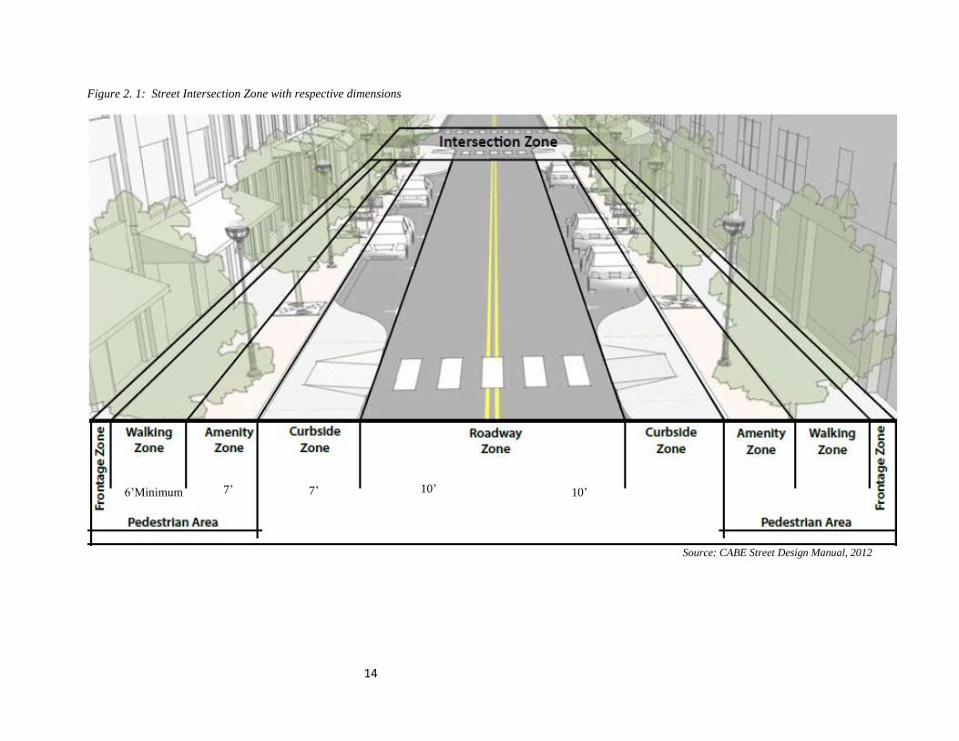
2-2.4 Street Zones & Design Elements
CABE (2012), argue that a street is considered to be the entire right-of-way or from building face
to building face in areas where buildings are situated on the front property line. Streets are further
divided into zones (see figure 2.1) as follows:
Roadway Zone: Includes travel lanes for traffic, including cars, transit, trucks, and bicycles.
Curb side Zone: May include parking lanes, bump outs, loading zones, and other uses adjacent
to the curb.
The Pedestrian Area: extends from the curb to the face of the building and/or the edge of the
right-of-way and encompasses the following three specific zones:
Amenity Zone: Between the curb and main sidewalk area, containing street furnishings,
amenities, landscaping, and expanded pedestrian areas.
Walking Zone: Primary through travel zone for pedestrian foot traffic and where paved
sidewalks are located.
Frontage Zone: Area between the sidewalk and building face. Often a 2 foot clear zone
immediately adjacent to buildings.
Intersection Zone: Area where streets intersection and location for crosswalks, traffic signals,
and other controls. Figure 2.1 illustrates street intersection zones.
2-2.5 Scheme Street Designs
According to New Zealand pedestrian planning and design Guide (2008), most roads must
accommodate a range of users. Their often conflicting requirements needs a balance to be struck
in the level of service provided for each user group and the allocation of limited space to each. The
guide further states that, to achieve an integrated approach, road controlling authorities (RCAs)
internationally are increasingly using a different type of hierarchy called a ‘road user hierarchy’
which endeavours to: bring non-private motor vehicle road users to the heart of the planning
process, ensuring the most vulnerable road users are considered early on and appropriately;
identify generally the importance of each travel mode for policies that impact across the various
components of the road user hierarchy; and lastly identify more specifically the importance of each
travel mode in localized situations based on local understanding and needs. In some cases, a user
hierarchy could even potentially change at different times of the day (for instance before and after
school).
13
The guide further argues that such an approach requires an awareness of the impacts and purpose
of the wider transport network, along with a strong understanding of the interaction of the different
transport modes, and the benefits and costs of different planning decisions or treatments for each
road user group. The guide argues that the first stage in a scheme development, therefore, would
be to identify the importance of different road user groups (their relative positions in the hierarchy).
As designs are developed they can then be assessed for their benefits and costs for different road
user groups, and in particular for those that have been identified as higher up the established road
user hierarchy. Manual for streets UK (2007), recommends that during a subdivision scheme, the
designers should follow the user hierarchy shown in Table 2.1. The manual states that applying
the hierarchy will lead to a design that increases the attractiveness of walking, cycling and use of
public transport. Delays to cars resulting from adopting this approach are unlikely to be significant
in residential areas.
Table 2. 1 Hierarchy of user consideration during scheme design
Consider first
Consider last
Pedestrians
Cyclists
Public transport users
Specialist service vehicles (e.g. emergency services, waste, etc.)
Other motor traffic
The manual explains further that the hierarchy is not meant to be rigidly applied and does not
necessarily mean that it is always more important to provide for pedestrians than it is for the other
modes, but rather, they should at least be considered first, then followed by consideration for the
others in the order given in table 2.1. This will help to ensure that the street serves all of its users
in a balanced way. There may be situations where some upper-tier modes are not provided for –
for example, buses might not need to be accommodated in a short, narrow section of street where
access for cars is required.
14
Figure 2. 1: Street Intersection Zone with respective dimensions
Source: CABE Street Design Manual, 2012
6’Minimum 7’ 7’ 10’ 10’
15
2-2.6 Historical Perspectives of Streets
Young et al. (2007), argue that most historic places owe their layout to their original function.
Towns have grown up around a market place, a bridgehead or a harbour; villages were formed
according to the pattern of farming and the ownership of the land. The layouts catered mostly
for movement on foot. The era of motorized transport and especially privately-owned motor
vehicles has, superficially at least, removed the constraint that kept urban settlements compact
and walkable. Stanley et al. (2007), argue that among the earliest written descriptions of cities,
cuneiform inscriptions from Babylonian cities mention three kinds of streets: (1) “broad street,
way of the gods and king,” (2) “narrow street, way of the people,” and (3) “blind alley” (Baker,
2009: 95). This ancient three-part classification matches our three urban scales, suggesting
continuity in the significance of streets from the earliest cities to the present. In ancient as in
modern cities, streets functioned as pedestrian and vehicular corridors as well as crucial locales
of social interaction, political demonstration, ritual, recreation, economic production, and trade.
The Romans constructed boulevards through the city for triumphal military parades, even
though these spaces were rarely used for other purposes (Favro, 1994). Chinese streets in
Chang’an, during the transition from the Tang (618–906 AD) to the Song period, morphed
from highly regulated space in which most activities were prohibited to informally regulated
places allowing diverse activities, including commerce (Heng, 1994). Teotihuacan in Mexico
had a long north-south open axis (today named “Street of the Dead”) lined by major buildings
and segmented by low, stepped, wall-like platforms. At the Aztec capital of Tenochtitlan, key
east-west avenues extended from the central precinct (Calnek, 1976, 2003). Roads at
Xochicalco, Morelos, continued into the countryside to project state dominance even though
human porters did not require them for transport (Hirth, 2003).
In many historical contexts, secondary streets have been the cultural and functional heart of
urban open space, home to a wide diversity of uses. In “Arab-Islamic” cities, generally lacking
in other open public spaces, primary streets functioned as critical transportation corridors
between extra-mural trading plazas and urban storefronts as well as marketplaces (Bianca,
2000). Under the Islamic tradition of generative building, streets can become progressively
narrower over time; Cairo’s Bayn al-Qasrayn, for example, began as a notable plaza in the 11th
century but shrank to street width due to political manipulation and the consistent
encroachment of residential buildings and shops (AlSayyad, 1994). In medieval European
cities, streets often represented extensions of working households and became sites of
economic production, sales, play, and social interaction (Mumford, 1961; Schlumbohm, 1980).

16
Beginning in the 19th century, Western urban planners sought to establish order by imposing
open, grid-like streets in dense urban zones or in newly planned districts, a phenomenon
culminating in the modernist emphasis on streets as mono-functional vehicular corridors,
backed by standardized codes (Trancik, 1986; Southworth & Ben-Joseph, 1997). Informal
settlements in modern developing countries, representing much of the world’s newly created
urban space, have trended in the opposite direction—the lack of planned open space forces
transportation to share streets with a wide variety of social, recreational, and economic
activities (Habitat, 1982). Housing in many ancient cities was probably constructed informally
(Smith, 2010), suggesting similar patterns in many but not all pre-modern cities. Cantona, in
Mexico, had a network of built streets and passageways, some converging on the main precinct
but most serving neighborhoods (Cook, 2003). Aztec Tenochtitlan was honeycombed with
canals and streets serving residences (Calnek, 2003).
Young et al. (2007), argue that when the regulation of roads and streets began, the spread of
fire was the main concern. Subsequently, health came to the forefront and the classic 36ft wide
bye-law street was devised as a means of ensuring the passage of air in densely built-up areas.
Later, the desire to guarantee that sunshine would get to every house led to the requirement for
a 70ft separation between house fronts, and this shaped many developments from the 1920s
onwards.
Bradbury et al. (2007), argues that it was not until after the Second World War, and particularly
with the dramatic increase in car ownership from the 1960s onwards, that traffic considerations
came to dominate road design. In the decades following the Second World War there was a
desire to achieve a clear distinction between the two types of highway. Traffic in Towns advised
that there should essentially be two types of highway – distributor roads, designed for
movement, where pedestrians were excluded or at least marginalized, and access roads
designed to serve buildings, with pedestrians allowed. This approach limited the provision of
multi-functional streets to the most lightly trafficked routes, an approach which had many
adverse consequences for pedestrians, cyclists and the public realm. It is now widely
recognized that there are many advantages in extending the use of multi-functional streets more
widely within urban areas. Making attractive streets that engender a sense of place amongst
local people is vital for the creation of sustainable communities (Young et al., 2007).
17
2-2.7 Theories of Urban Design
Figure-ground theory
This theory defines the physical spaces of a city as a solid-void pattern. It refers to building
masses as the solids, which forms the exterior space with both its shape and its exterior façade.
Aalto, A. & Schildt, G. (1998), argue that it is important to relate buildings with their
surrounding in order to form positive voids, where people tend to use that space more densely.
Susanna T. (1990), describes the relation of voids and solids as the sequences between open
spaces to more closed spaces which also can be varied in different shapes. Therefore, while
designing our towns designers should be aware of realities of modern urban trends which
require a balance between space for buildings and spaces set aside for residents to use. In this
case, more spaces should be provided where informal economic activities can be carried out
without being an impediment to other space users.
Linkage Theory
Trancik (1986), argues that Linkage theory was intended to identify the relations between the
spaces in more path wise way. The aim is to be understood as a try-out to make effective areas
of the city linked /related according to provisioned paths. It was highly popular in 1960s and
involved the organization of lines that connect the parts of the city, and the design of spatial
datum from these lines relate buildings to spaces. Linkage is simply the glue of the city.
Fumihiko Maki (2015), argues that linkage is the most important characteristic of urban
exterior space. The important point is to make comprehensible links between discrete things.
This results with the order and control within the city. When these linkages (streets) are not
well spread out in urban centres, then different users tend to compete for the available few for
their connectivity and linkage to various destinations. This is a major problem in the study area
in that the streets are not well linked, and therefore Mwihoko street (since is the only one that
is tarmacked), takes much of the pressure due to inadequacies of the other streets.
Place Theory
Trancik (1986), argues that place theory adds a ‘human touch’ to the other urban design theories by
paying attention to the historical, cultural and social setting of a particular urban design. While
the meaning of “space” is bounded or purposeful void with the potential of physically linking
things, it becomes “place” when it is given a contextual meaning derived from cultural or
regional content. Donald Appleyard (1981), in his work “livable streets project”, where he
explored the physical and social complexities of street, developed an ecology of street life. He
18
says people modifies their environment as a defense against traffic. He takes streets as spatial
entity. Thus, the different perception people have concerning the street leads to different ways
in which they use that space which in many cases may lead to conflict between users. As is the
case along Mwihoko street, users have different perceptions about the street and therefore
utilize it differently. Street vendors view it as a possible site with potential customers; while
boda bodas, buses & matatus view it as a termini.
2-3 Street as an Emerging Space for Contestation
2-3.1 Space Use Contestation
According to Kalipeni el al, (1999), there are many types of spaces which include: real spaces,
architectural spaces, imaginary spaces and symbolic spaces, such that, the term space resists a
single definition in either formulation or words. Geographers’ interest in the distinction
between ‘place’ and ‘space’ emerged during the 1970s, when a qualitative shift in the field of
geography paved the road to the development of social and cultural geography (Yakobi, 2004).
Tuan (1977) locates ‘space’ as a general term in opposition to ‘place’ as material. In other
words, space is nothing but the relationship between objects (Norberg, 1979).
Similarly, Madanipour (1996), distinguishes absolute space as a container of material objects
in opposition to relational space that is defined as perceived and socially produced. Relph
(1976), claims that place do not refer to the abstract but an experienced phenomenon. Thus,
place is a defined, built or natural space that has meaning (Noberg, 1979). By implication, this
phenomenological perspective urges planners to produce places not spaces. In other words,
spatial practices of planning are viewed as agents in the production of place.
According to Pratt (1999), contested spaces refer to social and economic spaces where cultures
meet, clash, and grapple with each other, often in context of highly asymmetrical relations of
power”. She goes further to state that, contested space can be identified to be space where
people or ideals collide resulting in the scramble for temporary place for each player within the
situation causing tension and friction among them. Contested space can vary from a very
physical sense, to a completely mental state, affecting how we go about our daily operations.
In this regard, contested space refers to the location on land where land uses compete for
accommodation and struggle to gain control of the place.
2-3.2 Public Space and Informal Activity
The concept of public space is a broad one with a multiplicity of divergent meanings and some
mainstream treatments of the subject focus on the politics of the ‘public sphere’ or ‘civic space’

19
in democratic societies (Drummond, 2000). Generally, these originate in notions of
unconstrained space within which political movements organize and expand into wider arenas
(Mitchell, 1995:116). Alternatively, it is represented as the material location where social
interactions and political activities of all members of the public occur (ibid). Such locations
usually serve as common grounds where people carry out the functional and ritual activities
that bind a community, including both the normal routines of daily life or periodic festivities
(Carr et al. 1992).
Public Space is almost by definition urban space, and Low & Smith (2006: 3) note that in many
current treatments of public space “the urban remains the privileged scale of analysis, and cities
the privileged site.” In their usage of the term, ‘public space’, the interests of urban designers
incline towards finding better ways of designing cities for leisure and aesthetic purposes or to
enhance urban vitality and improve security (Brown, not dated).
Designers and architects also explore how physical form and spatial relationships influence
people’s movement and experience of public space to facilitate social exchange and a vibrant
street culture (Brown, 2006). According to Low & Smith (2006), urban public space comprises
a range of social locations offered by the street, the park, the shopping mall and local
neighbourhoods etc. Brown (2006) also outlines the spatial specificity of urban public space as
comprising physical locations such as the square, pavement, sidewalk, boulevard, promenade,
esplanade, plaza, piazza, park, playground, mall, arcade and market. Typically, these physical
locales have a social significance as being “very recognizable geographies of daily movement”
(Low & Smith, 2003:3).
Therefore, more than the sheer vacuity of physical spaces, buildings or objects, people and
events and their relationships therein constitute the centrality of the conceptions of urban public
space. As Harvey (2006:17) acknowledges, “we do not, after all, experience the city blankly.”
According to Harvey (2006), urban public space may be interpreted to include “the long drag
of the commute, the jostle of subway crowds, the blandness of the shopping mall…the
panhandlers [and traders] on the sidewalk etc.” (ibid)
It is only intuitive that physical spaces that accommodate the social relations in cities will
normally belong in the non-private realm. Webster (2002) identifies the totality of these spaces
as the ‘public realm’ and defines the ‘public realm’ as the spatial domain within which de facto
or de jure economic or legal consumption rights over a local public good attribute are shared
by all individuals within a city for diverse purposes including circulation, transportation,

20
congregation and informal activity. Such spaces are thought of as ‘public realm’ because they
are jointly consumed by the public and they are contrasted with the private realm – space
consumed privately (ibid). Traditionally, rules of access, the source and nature of control over
entry, individual and collective behaviour sanctioned in specific spaces differentiate public
from private space (Lead, 2003; Webster, 2002; Benson, not dated).
Low & Smith (2006: 4) note that whereas private space is demarcated and protected by state-
regulated rules of private property use, public space, while far from free of regulations, is
generally conceived as open to greater or lesser public participation. Nonetheless, the
conceptualization of urban public space is beyond simple or neat delineation of physical spaces
into private and the public. There are situations where urban spaces may not be clearly
identifiable as either public or private. Brown (2002) argues that in such circumstances, urban
public space ought to encompass all the areas of the urban environment that are not exclusively
private but that has some degree of accepted and legitimate public or community use. These
include spaces between buildings and the plots on which they stand (Webster, 2002), areas of
land in government ownership including road reserves and underdeveloped or ill-defined
spaces (Brown, 2002).
The literature on urban space strikingly inclines towards the urban experiences of the West
drawing ample examples from Europe, North America and Australia. Set in western constructs,
experiences and interpretations of the city dating as far back as Greek antiquity, there is little
discussion about urban public space in developing cities where urban space constitutes between
a quarter and a third of all space (Brown, 2006; Brown 2002; Drummond, 2000). The
disproportionate representation both narrows the scope of the concept, rendering it
inappropriate for effective analysis of important trends in the urban built and natural
environments of developing cities.
For instance, in many developing cities various forms of space in the public domain have
evolved from their initially intended functions to embrace a diverse range of informal economic
activities. These spaces include streets, sidewalks, pavements, road reservations, walkways,
cab and mini-van stations, railway terminals, spaces between buildings etc. The expression of
urban public space has come to be defined by the architecture of the street and the diversity of
informal economic activity it accommodates. According to Brown (2006), this phenomenon
has emerged as the fundamental defining character of the image of towns and cities.
21
2-3.3 Factors that Influence Space Use Contestation
As much as streets may have great designs, but the users have different views on the usage,
then such streets cannot provide the community with its full benefits. Street as a public space,
change and take various forms for different people according to their values, ideologies,
opportunities and interests. These values in most cases, go against the norms and rules set by
the planners, urban designers, architects and surveyors. The multiplicity of publics with
different interests on the streets, leads to street space use Contestation. Factors that influence
people’s perception and therefore leading to space Contestation include:
a) Individual’s Interest
Healey (1993), argues that individuals have different interests and needs, and this makes it
difficult to identify common traits in a singular civic sense. She further says that social forces
such as globalization, polarization, and fragmentation; have made any singular identity more
of an inspiration than a reality. In reality, there are multiple publics conflicting and divergent;
competing for scarce resources, and left to their own devices to create their place. These
publics, or discourse communities, have their own goals, ways of understanding, and means of
furthering their aims (Healy, 1993, & Swales, 1990). The need for planners to define a singular
public interest can reinforce and create conflict & tension between the interests of various
publics or discourse communities. Agonisms and tensions are usually experienced when police
power is used to enforce the singular public interest created by the planner. Those in the
informal sector are roughed-up and chased out of spaces they occupy. Thus, the situation
deteriorates to a cat and mouse chase between the police and the street vendors.
b) Public Space
Not only are people becoming more private, but also there is a general consensus that public
space is increasingly privatized and exclusionary in regulatory and physical terms (Mitchell
2003; Soja 199 6; Davis 1990). This is partly a response to increased concern for order and
security in the public realm. Following severe disinvestment in cities, especially central cities,
the urban environments worldwide have witnessed and continue to be impacted by physical,
economic and social deterioration. Private property owners have abandoned buildings leaving
them to deteriorate. Concepts, such as the broken windows, placed significant blame on the
quality of public spaces proclaiming that an apparent lack of order invited and bred crime
(Kelling 1982). Such abandoned spaces tend to be viewed by others as public space that can be
converted for some other use. It is a natural reaction for cities and planners to exhibit concern
for these marginalized and deteriorated areas and the condition of the public space. There have
been a myriad of responses and trends to combat the condition of the public spaces that inform

22
our perception of communities. When the planner tries to provide guidance on how best such
areas may be utilized, their view may contradict those of many competing views of new
occupants who with displeasure may resist any attempt of reordering the affected place
according to the planner’s view.
c) Right to the City
“The right to the city” deals with social relations, alienation and the implications of the official
power structure in controlling and regulating the accessibility and function of public space
(Lefebvre, 1996; Mitchell, 2003, Banerjee, 2001). De Soto (2000), argues in his book “The
Other Path”: that the "informal economy is the people's spontaneous and creative response to
the state's incapacity to satisfy the basic needs of the impoverished masses" (p. 14). Hall &
Pfeiffer (2000), argue that the urban poor of the year 2000 have "built their own city without
any reference whatsoever to the whole bureaucratic apparatus of planning and control in the
formal city next door" (p. 15). The practice of place-making implemented by those that live
and use a space, and hence, define the experience and sense of place, has been referred to as
“the right to design the city” (Mattila, 2002). This right to design the city is limited. This is
partly because it has been determined that it is in the public interest to exert influence over the
experience of public space through ordinances, land-use policy, design guidelines,
redevelopment strategies, surveillance and police powers (Loukaitou-Sideris et al. 2005).
While in most times these strategies are effective in achieving the intended results, it should
also be noted that these regulations have effectively de-emphasized, privatized, and excluded
activities and people from public space (Loukaitou-Sideris et al. 2005). The implications of
these regulations and their effect on the production and experience of space have raised
concerns for social justice (Stout, 2008). Blomley (2004), argues in his book (Unsettling the
City: Urban Land and the Politics of Property), that in cities the ownership model of properties
is premised on the ‘right to exclude’, but such premise is challenged by those who experience
exclusion, and therefore, constantly devise ways and means to circumvent the exclusion.
d) Democracy and Participation
One way in which planners and designers address social justice is by promoting the concept
and practice of participation. There has been a championing of democratic processes in
planning as one of the most important opportunities for research (Kalinski 2006). Public
participation, is expected to increase in the planning process in Kenya since the enactment of
the new Constitution (2010). Still, participatory strategies of research are often limited in their
reach and feasibility for practical use by planners. The formal nature and expert knowledge of
planning therefore fails to be inclusive of the complexity of social relations (Stout, 2008).

23
According to report of Project for Public Spaces (2007), the issues associated with expert place
making practices are complex and problematic, leading to a number of problems with the
current trends of expert place making practices. The report states that there is growing
heterogeneity and divergence of the public interest which is difficult for planners to serve
through a centralized and generalized approach to place making. The report further argue that
the control and regulation of public space excludes certain persons and activities explicitly and
indirectly limiting the possibility and diversity of experiences. The report concludes by saying
that the result of place making is defined by those capable and willing to participate through
official processes, but unfortunately, the poor are rarely consulted and therefore, have no means
of participating in the process of place making. According to Stout, (2008) such exclusion leads
to the poor creating their own spaces in the city that are in contradiction with what the planner
and those that participated in the planning process, had in mind. With an understanding of the
growing separation between “expert producers” of knowledge and the life of “local
consumers”, the idea of the everyday developed by Lefebvre and deCerteau serves to legitimize
and strengthen the political dimension of everyday practices (Stout, 2008).
e) Every day Public Space/Loose space
It is from these basic ideas on the philosophy of everyday life that recent ideas of everyday
public space and loose space have become part of the lexicon in theories of urban design and
that offer new territory for understanding their democratic and participatory aspects. Every day
public space includes spaces that have been appropriated for temporary uses and have “multiple
and shifting meanings rather than clarity of function.” Everyday spaces represent a bottom-up
approach to re-configuring urban space that lies outside the professions of planning and design
where users are able to redefine the function a space should accommodate. Most importantly
they are distinct from the “normative public spaces, which produce the existing ideology, these
spaces help to overturn the status quo” (Crawford, 1999: 28).
Generally, loose space is similar to everyday space. It is made up of the publicly accessible
spaces in the city and those that offer a freedom of choice as well as physical elements that a
user can appropriate and re-configure. Loose space is predicated on group and individual
activities (Franck and Stevens, 2007: 2). Loose space can be planned as open space or as
leftover spaces that are usually publicly owned but void of any determined or exercised
function. Loose space affords opportunities and new possibilities to occur. It is the
“indeterminacy of loose space, along with free access, that opens the space to other
possibilities: to activities not anticipated, to activities that have no other place, to activities that
benefit from a relative lack of control and economic constraints” (Franck & Stevens, 2007: 17).

24
With this looseness comes a mixture of people with diverse interest, backgrounds and
intentions. This diversity “nurtures particularity in the urban public realm, sustaining local
practices and allowing the identity of a place and culture to flourish” (Franck and Stevens,
2007: 21). They further add that the ability to afford new meaning, intrinsic to the daily life of
users, enables urban space, public or private, to address the complexity of contemporary urban
condition. It is the reflection of values and beliefs in all their diversity and conflict that offers
the potential for lived, every day and loose space to engender stronger cultural and social
significance in a place and to provide for more democratic and participatory places.
f) More Meaningful, Diverse and Democratic Spaces
Because local practices allow for a more direct relationship between the user and the
environment, spaces can become more meaningful and significant. Not only do local practices
potentially produce more meaningful spaces because they exhibit the cultural and social
relationships inherent in our understanding of space, but should also produce more diverse
spaces (Crawford, 1995).
A community that utilizes certain means for various ends and defines space differently from
another community can coexist in the same space. The places of different publics can overlap
and inform others’ experiences. This diversity, when made manifest, is a means of various
groups building tolerance, consensus and understanding, in effect more justice. In this regard
local practices have interesting implications for the participatory nature of planning. Viewing
the individual actions as decisions that affect the experience of space, suggests that local
practices enable people to participate in production of space in ways that are related to their
values and cultural differences (Kalinski, 2006).
Not only does everyone have the right to the city, their everyday activities exercise their right
to design the city. This exists outside of traditional participation, but the dialogue that places
affords can be read as participation and signify demands of underrepresented citizens.
Innovations in participatory design processes as well as in the democratic functions of
governing are expanding. Considerations of the tools and experiences of users are becoming
critical for all planning practices (Kalinski, 2006).
Specifically, local practices of production of space offer planners with unlimited potential
resources for informing and implementing expert interventions in place making. The expert
and non-expert knowledge can enable the “communal practice of creating beloved spaces that
also enrich the basis for knowledge and our ability to situate knowledge in place while opening
spaces for multiple and contested meanings” (Schneekloth & Shibley, 2000: 133).

25
With the understanding of the nature of space use Contestation and the realms of space under
which it operates, this research seeks to allow for more meaningful, participatory and
democratic places, especially in locations where space is being contested by different groups
that have access to different participatory and power structures. In moving out of the realm of
expert practice we create new opportunities for place-making, to contribute to the vitality of
everyday life (Schneekloth & Shibley, 2000:130).
2-4 Planning and Development Implications of Space Use Contestation
Given the fact that the main functions of a street is: to provide circulation, for vehicles and
pedestrians; to provide access to buildings, and the provision of light and ventilation for
buildings; to provide routes for utilities; to provide storage space - especially for vehicles; to
provide public space for human interaction and sociability - everything from parades and
protests to chance encounters; - nearly all streets in urban areas perform all of these functions,
and often the balance between them will vary along the length of the street (CABE, 2002).
Ideally, all these facets of the street can successfully coexist, but in most cases it is one function
(movement of vehicles) which has been allowed to dominate. Getting the balance right at the
right place is critical because streets are the most important part of the public realm, and thus
fundamental on how we live together in towns and cities. They influence our lives at the
functional level (how to get around) but also in how we relate to each other and to public
authorities. They are the testing-ground for how we, as individuals, share the citizenship of the
places where we live and work. A famous court case on the use of the highway, summarizes
the duties which arise from sharing this common space:
‘The law relating to the user of highways is in truth of the law of give and take. Those who use them must in doing
so have reasonable regard to the convenience and comfort of others, and must not themselves expect a degree of
convenience and comfort only obtainable by disregarding that of other people. It is the price they pay for the
privilege of obstructing others.’
(Harper v. Haden & Sons Ltd 1932)
Street space use contestation may have various implications on the streets affected. According
to the ILO (2002), street vendors are often viewed as a nuisance or obstruction to other
commerce and the free flow of traffic. Their encroachment of road reserve results to absence
of clear street zones that leads to narrowing of the street. The ILO report further argues that the
struggle for control of space on the street leads to disorder resulting to: conflicting land use
activities, spill over into sideways, streets & open spaces. Another result they noted is the
environmental degradation due to enormous waste generated by various activities. The report
also highlights the increase in accidents on the affected streets. The report further notes that
demonstrations, chaos & battles results when authorities decide to remove traders from

26
occupied spaces. According to Tshedy (2016), encroachment of building structures onto road
reserves is another impact that results from street space contest and thereby interfering with the
functions of the street. The next section attempts to help explain how these groups manage the
spaces they occupy.
2-4.1 Informal Activities on Urban Streets
The informal sector constitutes economic activities involving the production and distribution
of goods and services that are not registered and regulated by the state or local government in
contexts where similar activities are regulated (Sinclair, 1978: 84; United Nations, 1996). Some
of the characteristics of the informal sector activities are: small scale, labour intensive, low
fixed costs, use of simple technology, reliance on family labour, use of personal or informal
sources of credit, non-payment of taxes, relatively easy to establish and exit (Hart, 1973; Fidler
and Webster, 1996; Hope, 2001).
Brown et al. (2014) states that the most common form of informal activity that is witnessed on
many streets, is street vending. For generations, street vending has provided vibrancy, colour
and a market outlet in many cities. However, as the 21st century progresses, the dynamic
growth of city populations, the scale of physical development, and globalizing economies,
create new challenges for street vendors, who face changing political, economic and social
contexts and increasing competition for space.
Brown et al. (2014) argue that today, modern street vending plays a vital role in the urban
economy where it acts as a source of employment, revenue from taxes and ‘value added’ to the
economy. He further states that street vending provides a flexible link in economic supply
chains, giving vitality to urban streets, and provides affordable goods for many urban residents.
But he cautions that street vending may exacerbate congestion at busy sites (e.g. city centres
where competition for space is acute), where vendors may lack the facilities for ‘decent work’.
Case Study 1 - Street Vending in India
Literature review reveals that Street vending provides many opportunities to a large population
of the Indian society. According to Inclusive Design for Street Vendors in India (2014), street
vending provides self-employment to a large number people. The report argue that street
vending can create an interesting city environment with all kinds of goods on display. It also
adds that street vending keeps the street busy, safe, providing goods and services at convenient
locations and at affordable prices. Plate 2.1 attempts to highlight this positive story;
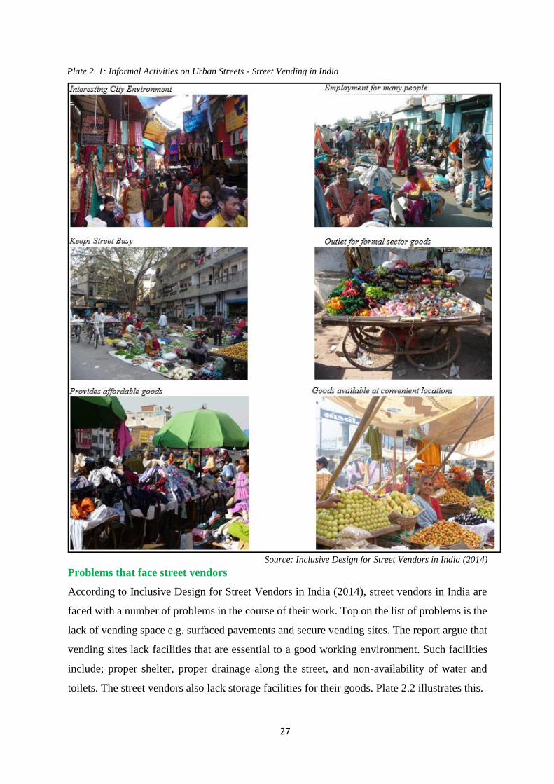
27
Plate 2. 1: Informal Activities on Urban Streets - Street Vending in India
Source: Inclusive Design for Street Vendors in India (2014)
Problems that face street vendors
According to Inclusive Design for Street Vendors in India (2014), street vendors in India are
faced with a number of problems in the course of their work. Top on the list of problems is the
lack of vending space e.g. surfaced pavements and secure vending sites. The report argue that
vending sites lack facilities that are essential to a good working environment. Such facilities
include; proper shelter, proper drainage along the street, and non-availability of water and
toilets. The street vendors also lack storage facilities for their goods. Plate 2.2 illustrates this.
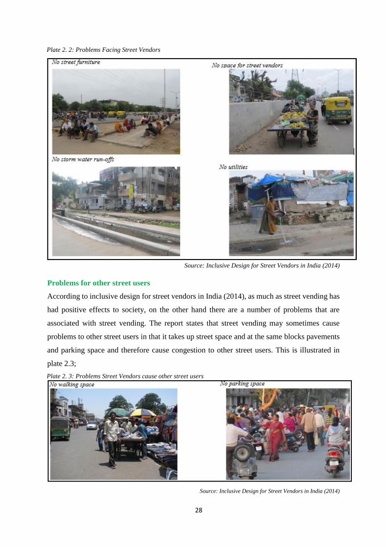
28
Plate 2. 2: Problems Facing Street Vendors
Source: Inclusive Design for Street Vendors in India (2014)
Problems for other street users
According to inclusive design for street vendors in India (2014), as much as street vending has
had positive effects to society, on the other hand there are a number of problems that are
associated with street vending. The report states that street vending may sometimes cause
problems to other street users in that it takes up street space and at the same blocks pavements
and parking space and therefore cause congestion to other street users. This is illustrated in
plate 2.3;
Plate 2. 3: Problems Street Vendors cause other street users
Source: Inclusive Design for Street Vendors in India (2014)

29
Case Study 2 - Buildings Encroaching onto the Street Area
A road reserve (as shown in section 2.1.4) is a legally described area within which facilities
such as utility lines, roads, pedestrian way, and associated features may be constructed for
public travel. There’s a problem in many urban centres, where road reserve encroachment has
been experienced. The encroachment becomes a challenge to deal with as there is resistance
from those who have encroached (Tshedy, 2016). Below is an Image of Quthing Showing
Encroachments and “Pinch” Points. In areas with Single Street, buildings either residential or
commercial, are lined on both sides and in many cases, have encroached into the road reserve.
Mostly you find cars parked on pavements where pedestrians are supposed to be walking, and
plans to expand such a road are limited (Tshedy, 2016). See pates: 2.4, 2.5 & 2.6.
Plate 2. 4: Image of Quthing Showing Encroachments and “Pinch” Points
Source: Tshedy, 2016
Plate 2. 5: Imagery of Quthing
Source: Tshedy, 2016

30
Plate 2. 6: Extraction from the imagery of the urban centre
Source: Tshedy, 2016
Plate 2.6 shows an extraction from the imagery of the urban centre. The Polygons which are
deep green in colour illustrate buildings in the road reserve, which is shown in a brownish
colour. Such Building Encroachment interferes with both pedestrians and vehicular movement,
and also the placement of utilities along the affected street.
2-5 Legitimacy of Street Vending
The study on street vending lacks both a well-defined theoretical framework and analytical
rigour. As a segment within the informal sector, debates about street vending are subsumed
within the theoretical discourses on the informal sector. Since its debut in development studies,
debates on the informal sector tend to be polarized into two grand discourses in socioeconomic
debates: the Reformist & Marxist schools (Nattrass, 1987), even though other discourses have
recently emerged i.e. the gender perspective, the health & environmental concerns, and other
debates around street vending (Jimu, 2004).
2-5.1 The Reformist School of Thought
The reformist school draws inspiration from the observations of the International Labour
Organization (ILO) mission to Kenya in the 1970s; Hart's discourses of the informal income
opportunities and urban employment of Accra, Ghana, in the 1970s and other country based
studies in the 1980s and 1990s; and the World Bank (WB) and African Development Bank
reports. The reformists perceive the informal sector as an important sector having vast vitality
for employment creation, on job training or developing entrepreneurial skills, and promoting
economic growth (Fapohunda, 1985; United Nations, 1996). This view has been echoed in a
large body of literature in developing countries experiencing precarious socio-economic

31
prospects due to declines of the formal economy, rising unemployment and underemployment,
and rising poverty levels (Rogerson and Hart, 1989; Hope, 1997, 2001). The general feeling is
that poor socio-economic prospects reflect the failure of conventional economic wisdom, one
that focuses attention on the government and the private sector as engines of economic growth,
employment, prosperity, success and general welfare of the people (Jimu, 2004). Considerable
rhetorical emphasis is placed on the potential role of the informal sector in alleviating poverty
and unemployment. The idea is to go informal or at least to recognize and promote the informal
ways of economic life popularly termed as the informal sector. However, there is little clarity
about precisely how such stimulation should occur, although it is acknowledged that the
competitiveness of the informal sector derives from a lack of bureaucratic and hierarchical
structures, unregulated operating environment, and informality, making business in the
informal sector cost-effective and profitable to the participants. Often, the argument has been
that, to enhance the benefits emanating from the informal sector, focus needs to be on securing
an environment free from bureaucratic constraints. However, it could as well be argued that,
the lack of regulation is a disincentive as it jeopardizes the vitality of the informal sector chiefly
because as a non-tax paying sector, governments are swift to disregard or at best, to ignore it
completely with grave consequences. Although there is growing toleration and acceptance of
the informal sector, is it realistic to expect governments to be proactive in promoting a sector
that makes no direct contribution to the tax base or revenue? Should the government invest
resources ameliorating such concerns as: inadequate provisions for premises, barriers of access
to credit and finance, inadequate social infrastructure and other public support and minimal
development assistance to a sector which makes little contribution to the tax base? (United
Nations, 1996: 17; Esim, 1996: 142-3). In the context of this study, the reformist school of
thought may be regarded as a pro informal economic activities since it supports its existence
by taking cognizance the critical role it plays in the wellbeing of society – where it can
contribute to poverty alleviation through provision of employment. Therefore the reformist
school of thought is in support of the objectives of this study which ultimately intends to solve
the problem of street space contest by accommodating all street users.
2-5.2 The Marxist school of thought
The Marxist school focuses on the structural dependency and exploitative relations between
the formal and informal sectors. In Marxist discourses, (Nattrass, 1987: 861), the informal
sector is a 'marginal' sector involving 'petty commodity production'. As a 'marginal' or a 'petty
commodity production' sector, Marxist theorists argue that the informal sector is just a distinct
32
'marginal pole' which by acting as a reserve army of labour and producing or offering cheap,
poor quality, subsistence goods and services; facilitates capital accumulation in the formal
sector (Tokman, 1978; Moser, 1978). By implication, the participants in the informal sector or
'the dangerous classes' (Fapohunda, 1985: 19) make little contribution to national gross
domestic product (GDP). This means that there would be very little loss to the economy, as a
whole, if the informal traders are taken off their occupation. Such a view is hostile to the
informal sector and governments pursuing this line of thinking do not see any need to provide
physical, economic and social space for informal economic actors, such as street vendors.
Such view is what usually lead street vendors to create their own space in urban areas from
where to operate contrary to vision of the urban planner and designer. It is however critical to
recognize that the informal sector is not just subordinate to the formal sector, as Marxists posit,
but that, it compliments, if not challenges the formal sector. Although both informal and formal
sectors of an economy, are subordinate to the structural constraints of the broader national and
global economy, the informal sector is a challenge to the formal sector, because it enhances
social justice by accommodating people not considered fit in the formal sector, by undermining
and even displacing the formal economy (Emizet,1998: 129). In the context of this study, the
Marxist school of thought goes contrary to the objectives set out since it tends to delegitimize
the existence of informal sector by referring to it as; a distinct marginal pole activity that is
subordinate to the formal economy, and therefore encourages those traders in the informal
sector to be taken off their occupation. Such a view that cannot be pursued in the study area
since doing so will be running away from current urban realities.
2-5.3 Health and Environmental Issues around Street Vending
Street vending is blamed for contributing to environmental problems. Street vendors are noted
for erecting structures, which do not by any means conform either to building codes, or zoning
regulations. Street vendors sometimes take-over sidewalks and force crowds out into the street
creating serious traffic snarl-up. Street food vendors are noted for generating excess litter,
which stretches the capacity of sanitation departments to keep the urban area clean. Street food
vending also poses health risks, particularly the spread of food-borne diseases (Bromley, 1978;
Rogerson and Hart 1989; Murry, 1991). Again street vending is a security concern; it
encourages crowding of people in the streets, thereby providing a haven for criminal activities
(Rogerson & Beavan, 1985). No wonder street vending is regarded as a social evil and an
affliction to be purged. Aesthetic, social, environmental and economic concerns highlighted
above minimize the comfort that is hypothetically a characteristic of urban life. Street vending
33
is regarded as an inappropriate form of earning a living and inconsistent with the ideals of
economic life for the city. Taking cities as the abode of modernity, one would be forced to
argue that street vending is inconsistent with modernity. Suffused with the ideology of
modernization, local and national governments, planners etc., may consider street vendors as
'obstacles' in the way of modernization (Post, 1996). In the context of this study, the health and
environmental issues around street vending may be true to a certain extent, but others are an
exaggeration. Some research have shown that street traders provide an extra eye on the street,
since criminals will not dare steal when there are many eyes looking at them. The urban planner
should not consider street vendors as 'obstacles' in the way of modernization but rather a reality
that should be recognized and accommodated in our urban system.
2-5.4 The Gender Perspective
The potential of the informal sector to promote social justice becomes clearer when one takes
a gender perspective, which focuses on the level of participation in the economy by males and
females. Studies in Africa and other countries in the developing world, indicate that women
constitute the principal labour force in the informal sector, particularly in such activities as
food and beverages, retail trade, pottery, basket weaving and cross border trade (Murry, 1991;
United Nations, 1996). A sectoral analysis of women's participation in the informal sector, for
instance, in the Democratic Republic of Congo (DRC), the Gambia and Zambia, indicates that
women are highly involved making 94.1, 88.9 and 90.6 percent of retailers, respectively
(United Nations, 1996:11). Researchers have argued that the dominance of female participants
in the informal sector is a factor of low education and employable skill levels among women,
which prevent a majority of them from directly enjoying the benefits of a growing formal
sector. However, radical feminists would argue that the trend reflects the gender imbalances
(with women relegated to the informal sector) inherent in patriarchal societal arrangements that
favour males to females, in education and skill training and employment. Hence, majority of
those contesting for space use on streets are women given the fact that they are financially
disadvantaged compared to their male counterparts, who can easily acquire spaces to operate
from or use their mighty to occupy more vantage point as compared to their female
counterparts.
2-5.5 Lessons Drawn in the Legitimacy of Street Vending
In summary, as a most conspicuous aspect of the urban informal sector, street vending is caught
within this matrix of pro and counter arguments of the informal sector. To the reformist, the
economic value of street vending cannot be overemphasized. Street vending contributes to job

34
creation, income generation and distribution, and conveniently provides goods and services
(Murry, 1991). In this regard, street vending provides a viable alternative for subsistence living
in urban areas to formal employment and the parasitic or anti-social occupations like theft,
prostitution and destitution (Murry, 1991).
Hart (1973), one of the pioneers in the informal sector scholarship, would argue that, it is a
buffer against instability and insecurity of work and income opportunities among the urban
poor. Street vending should therefore be seen as a survival strategy for the groups of people
relegated to work and eke out a meager existence in 'the dungeons of the informal sector'
(Rogerson and Hart, 1989: 29). Trading on the streets is or represents one particular avenue of
'legitimation and recognition' for urban residents who discover that the 'promises of modernity
are fast becoming a broken dream for all but an elite few' (Nyarnnjoh, 2002: 118, 120). Instead
of engaging in criminal activities, a considerable number of people settle for street vending to
make ends meet at the same time providing conveniently, cheap consumer goods at negotiable
prices. On the other hand, Marxists and administrators or governments pursuing this line of
thinking would perceive street vending less of an opportunity and more of a disincentive.
Critics, often from middle class orientations, the educated and those highly placed in society,
perceive street vending as a social problem and the street vendors as saboteurs of the urban
economy. Street vending is also perceived to be an inefficient, backward, irrational, and
frequently unhygienic form of economic activity. Often street vendors are paraded as tax
evaders (income tax, surtax, even market fees) and illegal consumers of public services and
spaces. City authorities are apt to argue that street vendors compromise efforts to institute order
in the organization and utilization of urban space and the satisfaction and efficaciousness of
urban life. These arguments are illustrated by the street vendors' conduct of business (Jimu,
2004). Generally, from all these views, the pros for the continued existence of informal
economic sector activities outweigh the cons propagated by some researchers. And therefore,
this goes on to support the objectives of this research which is to integrate the informal
economic sector activities to our urban system. Thus, this points to a fact that if informal
economic sector activities along Mwihoko street can be integrated into urban planning of
Githurai urban centre, many of the problems experienced will be minimized.

35
2-6 Innovative Planning Approaches to incorporate Urban Street
Vendors: Case Studies
Many countries have come up with policies to ensure that streets function well in terms of
being: a channel of movement, a communication space, a public space, a place of social and
commercial encounter and exchange, a place to do business, a political space and also a
symbolic and ceremonial space in the city. The following Case studies attempts to demonstrate
this:
2-6.1 Case Studies from Asia
Normal planning procedures provide various opportunities for vending on under-used space,
or the allocation of space through normal planning and zoning procedures. The following case
studies illustrate three types of planning intervention that have provided space for street
vendors:
a) Incidental space – identified through community led design: Jamalpur
Jamalpur Market, Ahmedabad, is a vegetable market accommodating about 675 vendors, at the
eastern end of Sardar Bridge at the junction of Bhagtacharya Road and Jamalpur Road, which
are connected by a new flyover. The informal market lies outside the Sardar Patel Agricultural
Produce Market Committee (APMC) market, the vegetable and grain wholesale market for the
district. Vendors buy in bulk from the main market and sell in smaller quantities along the
street. According to SEWA (2012), many attempts had been made to solve congestion
problems at Jamalpur…
1975 APMC shifted to Jamalpur; wholesale market attracted a few vendors
1979 Vendor numbers increased to 90
1985 Riots – more vendors shifted to Jamalpur for safety
1996 Vendors given demarcated space under Clean City campaign by AMC
2002 AMC built platforms for vending at an open plot beside the bridge
2003 Market and security poor, so vendors shifted back to the original place
2004 SEWA form a trust for vendor members, Jamapur Vechnara Bajar Sewa Samiti
2004 AMC wanted to allot riverside space to other vendors; vendors filed a case
2006 Court passed stay order
2008 Increase of vendors due to financial crisis; SEWA regulates vendors
2008 Flyover built under JNNURM project to reduce traffic congestion at junction
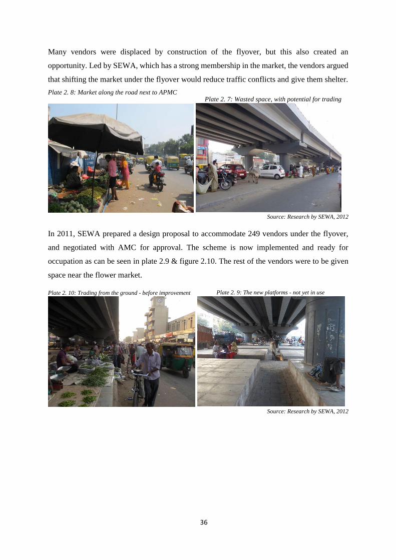
36
Many vendors were displaced by construction of the flyover, but this also created an
opportunity. Led by SEWA, which has a strong membership in the market, the vendors argued
that shifting the market under the flyover would reduce traffic conflicts and give them shelter.
Plate 2. 8: Market along the road next to APMC
Source: Research by SEWA, 2012
In 2011, SEWA prepared a design proposal to accommodate 249 vendors under the flyover,
and negotiated with AMC for approval. The scheme is now implemented and ready for
occupation as can be seen in plate 2.9 & figure 2.10. The rest of the vendors were to be given
space near the flower market.
Plate 2. 10: Trading from the ground - before improvement
Source: Research by SEWA, 2012
Plate 2. 9: The new platforms - not yet in use
Plate 2. 7: Wasted space, with potential for trading

37
Figure 2. 2: The Natural Market – Proposed Schematic Solution
Source: SEWA Proposal, use of incidental space under Jamalpur Bridge, Ahmedabad
b) Markets identified through planning legislation
Saiyadpura market
Under the Gujarat Town Planning and Urban Development (GTPUD) Act, 1976, Town
Planning Schemes must be prepared for existing and new areas. These allow for the allocation
of land for housing, retailing etc. In Surat, the GTPUD has been used to allocate vending areas
for convenience goods (vegetables and food items) in housing schemes, as in Saiyadpura
Market. Saiyadpura is primarily a meat market, catering to the local area. The market also
includes a Vegetable Market constructed by the Surat Municipal Corporation (SMC). SMC has
provided the vendors with platforms and has constructed a semi-permanent tin roof over the
whole market. SMC collects Rs. 2- 3/- per day for using the space, and there is storage inside
the market.
Plate 2. 11: Vegetable Market at Saiyadpura
Source: Research by SEWA, 2012
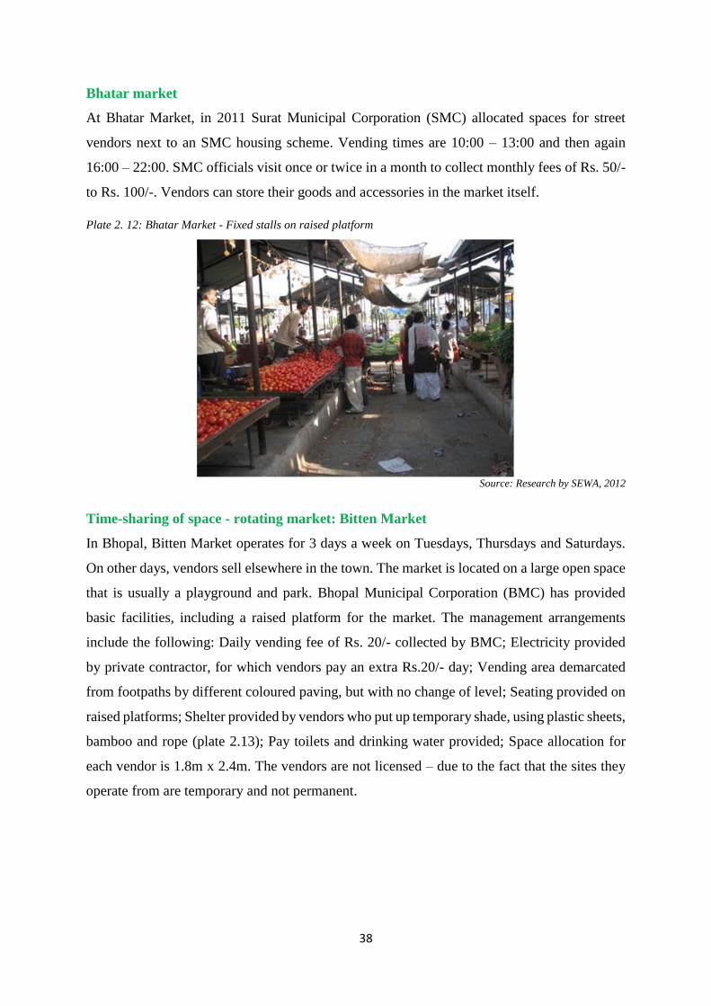
38
Bhatar market
At Bhatar Market, in 2011 Surat Municipal Corporation (SMC) allocated spaces for street
vendors next to an SMC housing scheme. Vending times are 10:00 – 13:00 and then again
16:00 – 22:00. SMC officials visit once or twice in a month to collect monthly fees of Rs. 50/-
to Rs. 100/-. Vendors can store their goods and accessories in the market itself.
Plate 2. 12: Bhatar Market - Fixed stalls on raised platform
Source: Research by SEWA, 2012
Time-sharing of space - rotating market: Bitten Market
In Bhopal, Bitten Market operates for 3 days a week on Tuesdays, Thursdays and Saturdays.
On other days, vendors sell elsewhere in the town. The market is located on a large open space
that is usually a playground and park. Bhopal Municipal Corporation (BMC) has provided
basic facilities, including a raised platform for the market. The management arrangements
include the following: Daily vending fee of Rs. 20/- collected by BMC; Electricity provided
by private contractor, for which vendors pay an extra Rs.20/- day; Vending area demarcated
from footpaths by different coloured paving, but with no change of level; Seating provided on
raised platforms; Shelter provided by vendors who put up temporary shade, using plastic sheets,
bamboo and rope (plate 2.13); Pay toilets and drinking water provided; Space allocation for
each vendor is 1.8m x 2.4m. The vendors are not licensed – due to the fact that the sites they
operate from are temporary and not permanent.

39
Plate 2. 13: Time-sharing of space – with Temporary shade
Source: Research by SEWA, 2012
Time-sharing of space: Sunday market, Bhopal
In Bhopal, the Sunday Market operates only on Sundays, when the roads are pedestrianised.
Paid parking is provided nearby to support market activities. There are no structures provided.
Bhopal Municipal Corporation (BMC) collects Rs. 20/- per day from each vendor. Electricity
is provided by a private service provider via generators for which Rs. 20/- per day is charged
separately. These vendors sell in Bitten Market on Thursdays, Tuesdays and Saturdays. The
vendors are not licensed. BMC has not allocated individual spaces for vendors, so spaces are
created through informal arrangements amongst vendors.
Plate 2. 14: Pedestrianised Street on Sunday
Source: Research by SEWA, 2012
2-6.2 Development of National Policies
In India the Supreme Court confirmed in 1989 that street vendors had the right to vend and that
streets were not only “meant exclusively for passing and re-passing and no other use”. In 2004,

40
a National Policy on Urban Street Vendors was adopted, reflecting a change from prohibition
to regulation of street vending. It seeks to legalize street vending by providing for legal vending
zones, establishing fee-based regulation rather than limited number of licenses, promoting the
organization of street vendors and implementing participatory mechanisms, amongst other
initiatives. The Policy calls for spatial planning norms that acknowledge and accommodate the
existence of demand-driven, locality-specific “natural markets” where street vendors tend to
congregate (WIEGO, 2011). Implementation of the policy at state level has proved challenging,
however, with only a few draft State-level laws based on this policy currently under discussion.
A new National Policy was adopted in 2009, revising the 2004 Policy. The revised policy
insisted on the need for a legislative framework and includes a Model Street Vendors
(Protection of Livelihood and Regulation of Street Vending) Bill.
2-6.3 Private Sector Involvement
Researchers have shown that the involvement of the private sector space creation, can go a long
way in solving problems of space to informal sector players. Kusakabe (2006), provides a good
practice from Thailand, by arguing that, one of the key to success, is dialogue between the
urban managers and street vendors. Managers need to accommodate street vendors. He
provides two examples of good practices: First case - An individual won a concession from
the ministry who owned the area, to manage a private market. The market is well-organized
and managed, resulting in a win-win situation for all parties involved. The owner goes around
the market every day and is responsive to the vendors’ problems. Second case - The market is
in a private company’s housing estate. The private company organised and managed the
market. A high rent is charged and high standards of hygiene, orderliness, and security are
maintained. At first, the vendors were not happy to relocate, but gradually, as business at the
market picked up and the managers tried to persuade the vendors, relocation was completed
and the market flourished. Through renovation by the company, the market has good
infrastructure, including restrooms and a car park, and this has contributed to the increase in
customers and consequently, an increase in income for vendors. Hence, vendors are also
willing to pay higher rent.
Rotterdam Market Hall in Netherlands
This is another example of how private sector involvement can contribute to space provision
for traders. It calls for innovative designs from architects, so that the building designs they
come up with, are inclusive (and not exclusive) in terms of use. See plate 2.15.
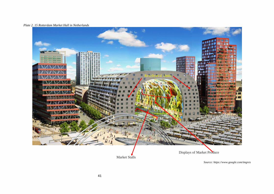
41
Plate 2. 15 Rotterdam Market Hall in Netherlands
Source: https://www.google.com/imgres
Residential Units
Displays of Market Produce
Market Stalls

42
Rotterdam Market Hall in Netherlands combines a residential project and a market hall - designed
by Dutch architects. This arch building comprises of 228 apartments, of which 102 are for rent. It
creates a large hall which houses 100 market stalls, shops and restaurants, 1200 parking spaces
and an underground super market (McManus, 2016). The apartments have a balcony on the outside
and a window to the inside of the market. Insulation prevents any unwanted effects. The 40 meter
tall and wide opening of the front and back are covered with a flexible suspended glass façade,
allowing for maximum transparency and a minimum of structure. The interior of the arch displays
market produce. Such a private investment, can solve many problems like; – parking lots,
residential units, clean environment, and a lively & vibrant surrounding.
2-6.4 Integrated Approaches to Support Street Vendors
This has been exemplified by Durban municipality in South Africa. The Self-employed Women’s
Union (SEWU), launched in 1994, and the Informal Trade Management Board, established in
1995, lobbied and negotiated with the Durban local authorities to obtain infrastructures for street
vendors. Their activities ensured the incorporation of vendors in city planning (Skinner, 2008:
233). In 2001, an acclaimed policy on Durban’s informal economy, inspired by several pilot
projects, was adopted. It made a number of suggestions for improving street vending with regards
to, for example, registration (simplification of the registration process and reduction of its cost),
site allocation (criteria for allocation should be negotiated with stakeholders and the allocation of
sites should then be done by officials), and operating charges (different transparent fees should be
set according to location, size and services provided; payment should be simplified). It established
a good framework principles for by-laws.
An integrated approach requires a continuous, consultative process with commitment and
competence on the sides of both the authorities and trade associations. Despite having adopted a
progressive informal economy policy in 2000 and spent considerable resources to construct
facilities for traders around the Warwick Junction transport node, Durban’s revamped City Council
resumed evictions and police actions against traders after 2004 – perhaps associated with a desire
to ‘develop’ the area in preparation for the 2010 World Cup (Skinner, 2008). The police started
removing street vendors merchandise at several locations in the city and the Council approved a
plan to stop “illegal, unlicensed street trading”. Since it had only issued 872 permits, most of street
vendors were considered illegal (Ibid. pp.236-237)
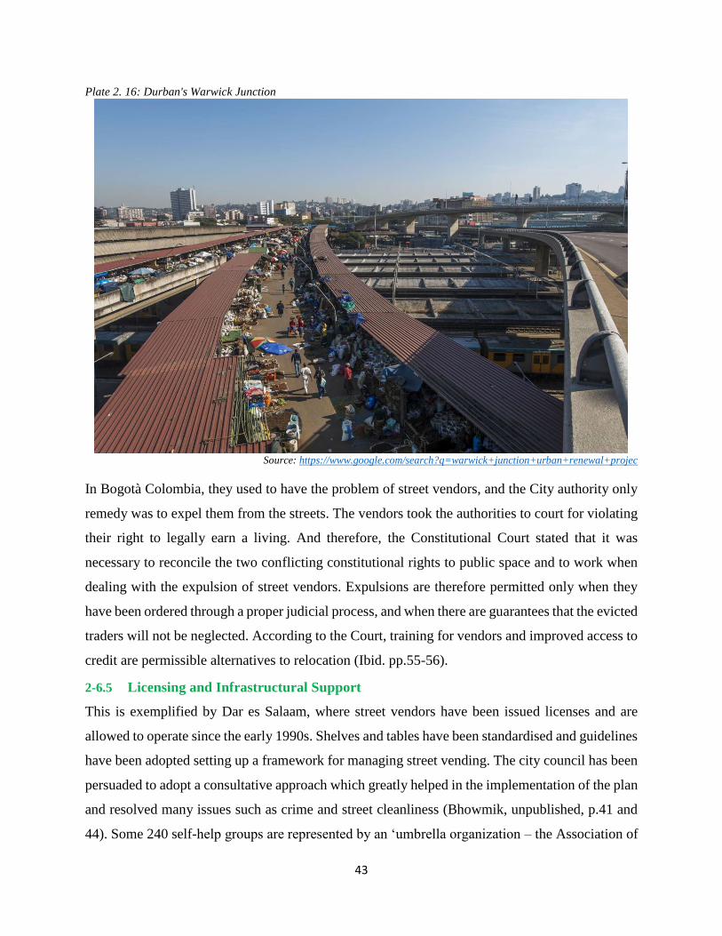
43
Plate 2. 16: Durban's Warwick Junction
Source: https://www.google.com/search?q=warwick+junction+urban+renewal+projec
In Bogotà Colombia, they used to have the problem of street vendors, and the City authority only
remedy was to expel them from the streets. The vendors took the authorities to court for violating
their right to legally earn a living. And therefore, the Constitutional Court stated that it was
necessary to reconcile the two conflicting constitutional rights to public space and to work when
dealing with the expulsion of street vendors. Expulsions are therefore permitted only when they
have been ordered through a proper judicial process, and when there are guarantees that the evicted
traders will not be neglected. According to the Court, training for vendors and improved access to
credit are permissible alternatives to relocation (Ibid. pp.55-56).
2-6.5 Licensing and Infrastructural Support
This is exemplified by Dar es Salaam, where street vendors have been issued licenses and are
allowed to operate since the early 1990s. Shelves and tables have been standardised and guidelines
have been adopted setting up a framework for managing street vending. The city council has been
persuaded to adopt a consultative approach which greatly helped in the implementation of the plan
and resolved many issues such as crime and street cleanliness (Bhowmik, unpublished, p.41 and
44). Some 240 self-help groups are represented by an ‘umbrella organization – the Association of
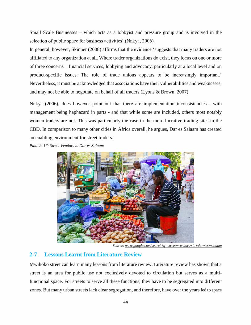
44
Small Scale Businesses – which acts as a lobbyist and pressure group and is involved in the
selection of public space for business activities’ (Nnkya, 2006).
In general, however, Skinner (2008) affirms that the evidence ‘suggests that many traders are not
affiliated to any organization at all. Where trader organizations do exist, they focus on one or more
of three concerns – financial services, lobbying and advocacy, particularly at a local level and on
product-specific issues. The role of trade unions appears to be increasingly important.’
Nevertheless, it must be acknowledged that associations have their vulnerabilities and weaknesses,
and may not be able to negotiate on behalf of all traders (Lyons & Brown, 2007)
Nnkya (2006), does however point out that there are implementation inconsistencies - with
management being haphazard in parts - and that while some are included, others most notably
women traders are not. This was particularly the case in the more lucrative trading sites in the
CBD. In comparison to many other cities in Africa overall, he argues, Dar es Salaam has created
an enabling environment for street traders.
Plate 2. 17: Street Vendors in Dar es Salaam
Source: www.google.com/search?q=street+vendors+in+dar+es+salaam
2-7 Lessons Learnt from Literature Review
Mwihoko street can learn many lessons from literature review. Literature review has shown that a
street is an area for public use not exclusively devoted to circulation but serves as a multi-
functional space. For streets to serve all these functions, they have to be segregated into different
zones. But many urban streets lack clear segregation, and therefore, have over the years led to space

45
contest among different users. This has come about as a result of high rate of urbanization which has seen
many people moving to urban areas in search of employment and better life opportunities. Literature
review has also shown that the huge number of people who have moved to urban areas have
overwhelmed the available resources and job opportunities. As a survival mechanism, the excess
population has devised ways of surviving the urban hardships. And one way of doing this, has
been through joining the informal economic sector, more so, street vending which does not require
a lot of capital to join.
Literature review shows that much of the urban land is in the hands of private individuals. Due to
the fact that planners define a singular public interest to urban space, this usually creates conflict
& tension between the interests of various publics. And therefore, those joining the informal sector
have devised ways of creating spaces for themselves to operate from due to their different
perceptions of space. The review also shows that modern street vending plays a vital role in the
urban economy where it acts as a source of employment, revenue from taxes and ‘value added’ to
the economy. Street vending also provides a flexible link in economic supply chains, giving vitality
to urban streets, and provides affordable goods for many urban residents. But literature review has
also shown that street vending may exacerbate congestion at busy sites. Street vending takes up
space and at the same time block pavements and parking space and therefore cause congestion to
other street users. Street vendors end up erecting structures that encroach and interfere with both
pedestrians and vehicular movement, and also the placement of utilities along the affected street.
Once street vendors encroach a street, the encroachment becomes a challenge to deal with as there
is resistance from those who have encroached.
Literature review has shown how different arguments have been put forward by various
researchers concerning street vendors. The arguments are for pro and counter arguments of the
informal sector. To the reformist, street vending contributes to job creation, income generation and
distribution, and conveniently provides goods and services. Therefore, street vending provides a viable
alternative for subsistence living in urban areas to formal employment and the parasitic or anti-social
occupations like theft, prostitution and destitution. It is a buffer against instability and insecurity of
work and income opportunities among the urban poor. This view is a pro informal economic
activities since it supports its existence by taking cognizance the critical role it plays in the
wellbeing of society – where it can contribute to poverty alleviation through provision of
employment. Therefore the reformist school of thought is in support of the objectives of this study
46
which ultimately intends to solve the problem of street space contest by accommodating all street
users. To the Marxist discourses, the informal sector is a 'marginal' sector involving 'petty
commodity production'. The Marxist theorists argue that the informal sector is just a distinct
'marginal pole' which by acting as a reserve army of labour and producing or offering cheap, poor
quality, subsistence goods and services. They add that the participants in the informal sector make
little contribution to national gross domestic product (GDP), meaning that there would be very
little loss to the economy, as a whole, if the informal traders are taken off their occupation.
Therefore, the Marxist school of thought goes contrary to the objectives set out since it tends to
delegitimize the existence of informal sector by referring to it as; a distinct marginal pole activity
that is subordinate to the formal economy, and therefore encourages those traders in the informal
sector to be taken off their occupation. Such a view that cannot be pursued in the study area since
doing so will be running away from current urban realities.
Some researchers have argued that Street vendors sometimes take-over sidewalks and force
crowds out into the street creating serious traffic snarl-up. Street food vendors are noted for
generating excess litter, which stretches the capacity of sanitation departments to keep the urban
area clean and therefore affecting the environment. Others have argued that street vending
sometimes takes a Gender Perspective, whre they say that majority of those contesting for space
use on urban streets are women given the fact that they are financially disadvantaged compared to
their male counterparts, who can easily acquire spaces to operate from or use their mighty to
occupy more vantage point as compared to their female counterparts.
Literature review has shown that some countries have adopted innovative planning in order to
ensure that streets function well. India exemplifies this with a National policy that support street
vending. This policy was accomplished with greater involvement and input of street vendors, and
has streamlined the vending activities within urban centres. Some countries support the
involvement of Private Sector in the provision of space for street vendors. This was evidenced
from case studies in Thailand, and Rotterdam Market Hall in Netherlands. This is a route that can
be pursued in our urban systems since most of land is in private hands. Another approach adopted
is the one by Durban municipality in South Africa which took an integrated approach to create
space for informal traders. An integrated approach requires a continuous, consultative process with
commitment and competence on the sides of both the authorities and trade associations.

47
In other countries like Colombia, the right to public space and to work is protected in the
constitution. The courts ruled that expulsions are permitted only when they have been ordered
through a proper judicial process, and when there are guarantees that the evicted traders will not
be neglected. According to the Court, training for vendors and improved access to credit are
permissible alternatives to relocation. This is a good guarantee for informal traders that can be
replicated in Kenya, which has a large number of people involved in the informal sector. Dar es
Salaam in Tanzania, has adopted a Licensing and Infrastructural Support, where street vendors
have been issued licenses and are allowed to operate since the early 1990s. Shelves and tables have
been standardized and guidelines have been adopted setting up a framework for managing street
vending. The city council has been persuaded to adopt a consultative approach which greatly
helped in the implementation of the plan and resolved many issues such as crime and street
cleanliness.

48
2-8 Conceptual Framework
Figure 2. 3: Conceptual Framework
Causes
Causes
POLICY
ON
STREET
FUNCTIONALITY
Poor street design
Increased urban population
Lack of Job Opportunities
Poor planning or lack of it
Lack of enough space to accommodate the large
number of people in need of it
Perception of space
Ineffective institutional framework
Weak policy and legal framework
Political interference
Poor enforcement of existing laws and regulation
Poor institutional capacity in terms of: finances &
personnel at the county level
Lack of proper organisation of street vendors into
strong association
Lack of dialogue between street vendors and
authorities Lack of stakeholder consultation
Interventions – at Site level
specific & at Policy level
Proper planning
Strengthening institutional
capacity
Encourage creation of strong
trade associations
Involvement of stakeholders
in policy formulation
Involve private investors in
managing vending sites
Have good road design that
will accommodate street
vendors on the side walks
Provide financial assistance
Urban renewal to include
paving of all sites used by
vendors, so as to improve on
hygiene & also make passage
possible when it rains
Contestation of Street Space Use
Balancing Competing Demands for Street Space
Struggle for control of space leading to disorder
Encroachment into the road reserves
Conflicting land use activities
Demonstrations, chaos & battles when
authorities decide to move the traders from the
occupied spaces
Environmental degradation due to enormous
waste generated from various activities
Spill over into sideways, streets, open spaces
Accidents on the affected streets
Effects
Source: Author, 2016
Plate 3. 1 Google
Image of the study
areaSource: Author,
2016
Results from:
Results from:
Leads to
Leads to
Can be minimised
Can be minimised
Can be minimised
Can be minimised
Achieved by
Achieved by

49
The Conceptual Framework in figure 2.3, shows that Space contestation in the study area has both
causes and effects that needs to be balanced in order to bring harmony to all street users. This can
be achieved through certain interventions that should be at both site level and at policy level. The
main sources of street space use contestation in the study area include: Street vendors; adjacent
formal enterprises; other informal activities like - Matatus, cyclists, wheel barrow & cart pushers,
butcheries, barbershops; and Pedestrians who may be passengers or shoppers. The possible causes
for space use Contestation in the study area include: Increased urban population; Lack of Job
Opportunities; Poor planning or lack of it; Lack of enough space to accommodate the large number
of people in need of it; Perception of space by different individuals; Ineffective institutional
framework; Weak policy and legal framework; Political interference where those involved are
considered voters; Poor enforcement of existing laws and regulation; Poor institutional capacity in
terms of finances & personnel at the county level; Lack of proper organisation of street vendors
into strong association that can push for their rights; Lack of dialogue between street vendors and
authorities; and lastly, Lack of stakeholder consultation when making decisions on land use. Some
of the effects of space Contestation include: Struggle for control of space leading to disorder;
Encroachment into the road reserves; Conflicting land use activities; Demonstrations, chaos &
battles when authorities decide to move the traders from the occupied spaces; Environmental
degradation due to enormous waste generated from various activities; Spill over into sideways,
streets, open spaces; and increased accidents on the affected streets.
All the above can be controlled by balancing demands for street space use which can be done
through intervention measures that may be required to contain space use contestation like: Proper
planning; Strengthening institutional capacity; Encourage creation of strong trade associations;
Involvement of stakeholders in policy formulation; Involve private investors in managing vending
sites; Have good road design that will accommodate street vendors on the sidewalks; Provide
financial assistance; Urban renewal to include paving of all sites used by vendors so as to improve
on hygiene & also make passage possible when it rains. Lastly, advocate the national government
to come up with laws that support informal sector, and also have flexible laws that will allow
private developers to convert their properties to indoor markets that can accommodate traders. A
challenge can also be directed to architects to come up with innovative building structures like the
Rotterdam Market Hall in Netherlands, so as to provide space for informal activities.

50
CHAPTER 3: RESEARCH METHODOLOGY
3-1 Introduction
This section presents the methodology used in the research project. The research methodology is
geared towards realizing the objectives of the study. This section therefore, outlines the procedures
used to achieve the objectives of the study i.e.: research design, research population & sampling
plan. It also explains the various data needs and sources of data for the project as summarized in
the data needs matrix. It also outlines data collection methods, and finally, it outlines sampling
methods, methods of data analysis and presentation used in the research project.
3-2 Research Design
Research design provides a framework for collecting and analysing data. The study employed a
non-experimental research method that used both qualitative and quantitative approaches. Figure
3.1 outlines a summary of the study Methodology Flow. The first stage entailed coming up with
a data need matrix that then guided the whole study in terms of data required & possible sources
of such data. This helped in deciding on the best method to be used for collecting the required data.
The method of data collection gave an indication on the kind of analysis that should be expected,
and also determined the data presentation techniques that was to be used. The data presentation
techniques helped to determine the expected results from the whole process. This was then
followed by preliminary study on the research project that included: Introduction & Background
to the Problem; Defining Research Problem; Identification of Research Aims, Questions &
Objectives; Justification & Significance of the Study; Assumptions & Limitations of the study;
and Research methodology. The second stage entailed collection of secondary data guided by data
needs and data sources that had been identified in the first stage. Data sources was from both
primary and secondary sources. Secondary data sources included review of Literature of past
studies on street space use contestation. The literature was obtained from books, journals,
government documents, Conference papers, unpublished research projects, internet publication,
and relevant documents relating to the study topic. The purpose of this was to familiarize and
synthesize arguments and ideas on street space use contestation. The literature review focused on:
Concepts, Theories and debates on street space use contestation, and policies on street functionality
& informality on urban streets (mostly in places of Commons), and planning approaches that have
been used to mitigate the problem. This aided in the formulation of a conceptual framework that

51
guided the inquiry of the research, and provided a tentative theory (explanation) of their
interactions.
Figure 3. 1: Research Methodology Flow chart
Source: Author, 2016
The third stage involved collection of necessary primary data for the project from field surveys.
This was guided by the data needs and data sources, as had been identified. The data collection
was done through field surveys where administration of pre-survey questionnaires was done, with
the aim of testing their suitability in the field. This enabled amendments to be made to the
questionnaires in order to make them workable. Later the administration of data collection
instrument was conducted with the aim of collecting the desired data. The data collection
instrument that were used include: questionnaires, interview schedule for the key informants,
camera, maps, tape measure, tally sheet and note book. The other work that was done at this stage
include: content analysis, spatial analysis, qualitative analysis, and quantitative analysis - using
appropriate techniques like; SPSS, Microsoft Excel and GIS. It involved analysis of the collected
Preliminary Stage
•Introduction & Background to the Problem
•Defining Research Problem
•Identification of Research Aims, Questions & Objectives
•Justification & Significance of the Study
•Assumptions & Limitations of the study
•Research methodology
Data Collection
• Examination of documents & materials – best practices, interventions
• Observations – visual characteristics of study area recorded on maps & observation forms
• Administration of survey instruments – questionnaires
• Interviews – key informants
Data Analysis
• Content Analysis - qualitative
• Spatial Analysis
• Discriptive analysis - quantitative
Final Stage
• Presentation of findings
• Conclusion
• Recommendations
• Written Report

52
data from both secondary and primary sources. The fourth stage involved compilation of research
findings and presentation of the findings in terms of: written report, maps, google images,
inventories, sketches, drawings, plans, pie charts, graphs, tables, and photographs, which was then
followed by conclusion, and formulation of recommendations - done to address the situation on
the ground.
3-3 Research Population & Sampling Procedures
The study population was selected based on the data needs of the project. The population was
divided into strata for ease of data collection and analysis. A complete enumeration in many cases
is impracticable, and hence sample surveys. Sampling saves on labour, in that a small staff is
required both for fieldwork and for tabulation and processing data. And therefore, Sampling was
used to arrive at the desired target population due to its ability to: reduce cost of research; reduce
time of study; cover wider scope; and it gives greater accuracy. The study population consisted of
people who in one way or another have some interest on Mwihoko Street.
3-3.1 Sampling Frame
A sampling frame was developed by visiting the study area and identifying groups of people
involved in activities contesting for space use, and they included: traders (street vendors);
pedestrians (potential customers); Vehicular (vehicle, passengers) - Bus, Tut-tut, & Matatu
operators; motor cyclists (Boda bodas); adjacent land owners; and key informants; who all formed,
the target population for the study from which samples were taken. The sample distribution of the
strata were based on facts gathered from the study area indicating that street vendors are the
majority, and so more weight was assigned to them. The rest of the strata, due to their
homogeneity, were given nearly equal weights.
3-3.2 Sample Size
For populations that are large, Glenn D. Israel (1992) cites an equation developed by Cochran
(1963:75) that yields a representative sample for proportions. See below;
This equation is valid where n0 is the sample size, Z2 is the abscissa of the normal curve that cuts
off an area α at the tails (1 - α a equals the desired confidence level, e.g., 95%), e is the desired
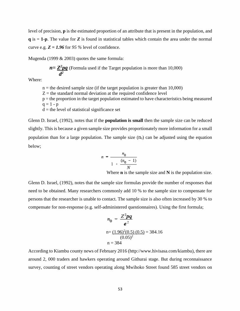
53
level of precision, p is the estimated proportion of an attribute that is present in the population, and
q is = 1-p. The value for Z is found in statistical tables which contain the area under the normal
curve e.g. Z = 1.96 for 95 % level of confidence.
Mugenda (1999 & 2003) quotes the same formula:
n= Z2pq (Formula used if the Target population is more than 10,000)
d2
Where:
n = the desired sample size (if the target population is greater than 10,000)
Z = the standard normal deviation at the required confidence level
p = the proportion in the target population estimated to have characteristics being measured
q = 1 - p
d = the level of statistical significance set
Glenn D. Israel, (1992), notes that if the population is small then the sample size can be reduced
slightly. This is because a given sample size provides proportionately more information for a small
population than for a large population. The sample size (n0) can be adjusted using the equation
below;
Where n is the sample size and N is the population size.
Glenn D. Israel, (1992), notes that the sample size formulas provide the number of responses that
need to be obtained. Many researchers commonly add 10 % to the sample size to compensate for
persons that the researcher is unable to contact. The sample size is also often increased by 30 % to
compensate for non-response (e.g. self-administered questionnaires). Using the first formula;
n= (1.96)2(0.5) (0.5) = 384.16
(0.05)2
n = 384
According to Kiambu county news of February 2016 (http://www.hivisasa.com/kiambu), there are
around 2, 000 traders and hawkers operating around Githurai stage. But during reconnaissance
survey, counting of street vendors operating along Mwihoko Street found 585 street vendors on
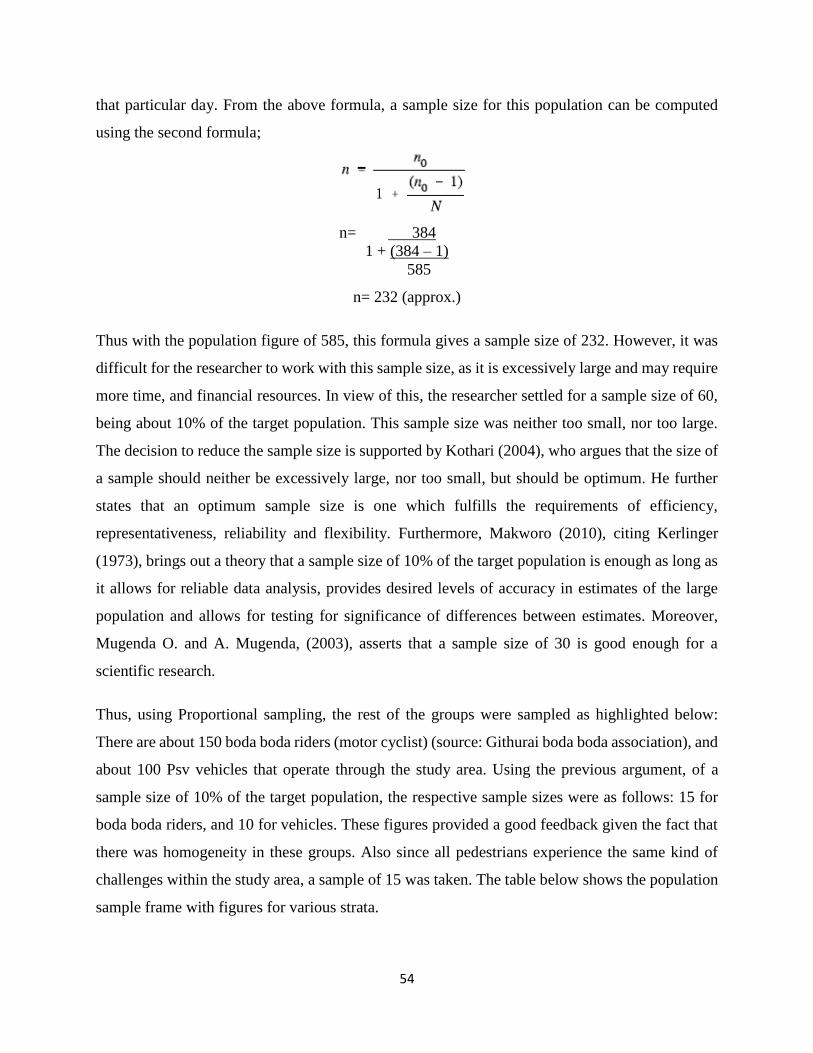
54
that particular day. From the above formula, a sample size for this population can be computed
using the second formula;
n= 384
1 + (384 – 1)
585
n= 232 (approx.)
Thus with the population figure of 585, this formula gives a sample size of 232. However, it was
difficult for the researcher to work with this sample size, as it is excessively large and may require
more time, and financial resources. In view of this, the researcher settled for a sample size of 60,
being about 10% of the target population. This sample size was neither too small, nor too large.
The decision to reduce the sample size is supported by Kothari (2004), who argues that the size of
a sample should neither be excessively large, nor too small, but should be optimum. He further
states that an optimum sample size is one which fulfills the requirements of efficiency,
representativeness, reliability and flexibility. Furthermore, Makworo (2010), citing Kerlinger
(1973), brings out a theory that a sample size of 10% of the target population is enough as long as
it allows for reliable data analysis, provides desired levels of accuracy in estimates of the large
population and allows for testing for significance of differences between estimates. Moreover,
Mugenda O. and A. Mugenda, (2003), asserts that a sample size of 30 is good enough for a
scientific research.
Thus, using Proportional sampling, the rest of the groups were sampled as highlighted below:
There are about 150 boda boda riders (motor cyclist) (source: Githurai boda boda association), and
about 100 Psv vehicles that operate through the study area. Using the previous argument, of a
sample size of 10% of the target population, the respective sample sizes were as follows: 15 for
boda boda riders, and 10 for vehicles. These figures provided a good feedback given the fact that
there was homogeneity in these groups. Also since all pedestrians experience the same kind of
challenges within the study area, a sample of 15 was taken. The table below shows the population
sample frame with figures for various strata.
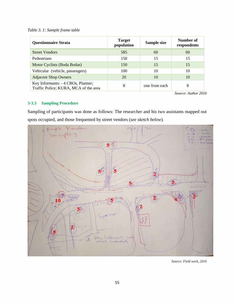
55
Table 3. 1: Sample frame table
Questionnaire Strata Target
population Sample size
Number of
respondents
Street Vendors 585 60 60
Pedestrians 150 15 15
Motor Cyclists (Boda Bodas) 150 15 15
Vehicular (vehicle, passengers) 100 10 10
Adjacent Shop Owners 20 10 10
Key Informants: - 4 CBOs, Planner;
Traffic Police; KURA, MCA of the area 8 one from each 8
Source: Author 2016
3-3.3 Sampling Procedure
Sampling of participants was done as follows: The researcher and his two assistants mapped out
spots occupied, and those frequented by street vendors (see sketch below).
Source: Field work, 2016

56
The mapping of hot spots was carried out during reconnaissance. The hot spots were picked on
both sides of the street, and a decision arrived at, as to the number of street vendors that were to
be presented with questionnaires. The sketch above outlines this: - the numbers shown represents
the respondents proportionally selected to fill questionnaires at a given hot spot. Hence,
proportional sampling was used to identify the specific persons to answer the questionnaire. At a
given hot spot, simple random sampling was used for the fact that some vendors were non-
responsive as they were busy, and because of time constraints, the interviewer would go to the
next available vendor. This procedure was repeated till all the questionnaires were administered in
all selected areas. Simple random sampling was used to interview: pedestrians, motor cyclists,
adjacent shop owners, and vehicular drivers. For pedestrians, the research assistants took strategic
positions along the street from where willing pedestrians could be interviewed. For boda bodas,
the research assistants visited various spots identified as occupied by boda bodas, and interviewed
the cyclists. For shop owners, simple random sampling was used to interview them in their shops.
For drivers, simple random sampling was used to get their views about the challenges facing them
as street users. This took place when there was a jam, and so the interviewer would move with the
vehicle, while putting across questions. For key informants, purposive sampling was used to
identify key informants who were interviewed during field survey. The key informants involved
stakeholders who had been identified during reconnaissance as those involved in one way or
another, with activities undertaken in the study area. They included: representatives of Matatu
Sacco’s, representatives of motor cyclists, representatives of street vendors, representatives of
adjacent land owners, County Physical Planner, KURA, Traffic Police, and MCA of the area. Each of
them was visited and interviews conducted separately, except the MCA of the area who was not available
for the interview.
3-4 Data Needs, Sources and Methods of Data Collection
Data Collection was done using the following methods: Examination of documents & materials –
best practices, interventions; Observations – visual characteristics of study area that was recorded
on maps & observation forms; Administration of survey instruments – questionnaires; &
Interviews – for key informants. The data was from both secondary and primary sources:

57
3-4.1 Secondary Data Collection
The secondary data sources included: books, journals, government documents, Conference papers,
unpublished research projects, internet publication, and other relevant documents relating to urban
street space, and informal sector, in Kenya and from other parts of the world. Data collection
entailed content analysis of the relevant literature and case studies, with the aim of gaining a deep
insight on the area, the problem, and on the enhancement of conceptualization. It involved desktop
research on street design, street functionality, informal sector activities, urban street space use
contestation and activities that contest for space use on urban streets. Other areas looked at include:
historical background of the study area, geographical location, development trends of the area,
demographic figures of the area - sourced from KNBS, situational analysis data (climate, geology,
soils, physical infrastructure, socio- infrastructure, current trends from other countries faced with
the same problems, governments response to the sector, legal and policies frame work put in place
to guide the sector. All these were recorded and enabled in coming up with the project proposal
that then guided the whole study.
3-4.2 Primary Data Collection
Primary data was gathered through observations, field survey, and key informant interviews.
a) Reconnaissance
This stage involved visiting the study area and the neighbourhood so as to understand it better.
This helped in identifying the scope of the study area, the extent to be covered, and the nature of
respondents available. The interviews were first preceded by a reconnaissance survey to have an
overview of the nature of space contestation along Mwihoko Street and other adjoining streets. In
so doing, basic characteristics of street vending were recorded. These included the location, type
of goods sold, type of structure used in vending and whether the vendors operated in a particular
locations or moved from one location to the other. A questionnaire was then prepared and tested
along the street to check its effectiveness. Based on the responses, a final questionnaire was
produced for the survey.
b) Observation
This technique was used to collect data on the kind of structures existing along the study area and
their condition. It also involved making observation on the street design to find out if it was
designed to serve the principal functions of an urban street, street signage, road bumps, and
58
pedestrian crossing signage. Building form and line, material used in their construction were also
observed. Observations were also made on the siting of businesses in relation to the street, the
condition of the street and the adjoining ones within the study area, the various activities the street
vendors are involved in, peak and off-peak period during the day for vending activities, any other
activity (motor bikes, tuk tuks, bus terminus) that was thought to be interfering with the smooth
flow of traffic along Mwihoko street, and any other data that was considered important for project.
Photography
This basically entailed taking pictures of various phenomena for illustration purposes. Photographs
were taken to help in the collection of data on land use patterns and activities taking place within
the study area. It also helped gather data on the condition of Mwihoko Street and the structures /
buildings along the study area.
Sketching
This was used to sketch various features for the purpose of illustration which included the building
elevations and lines along the street, cross-sections of the street at various points of interest and
sites most affected by contestation.
Mapping
Maps and satellite images were used to gather data on the spatial organization of the study area
and the surrounding areas. Mapping was also used to analyse street organization and the
neighbouring land use morphology in the study area.
c) Administration of Survey Instruments - Questionnaire
Questionnaires were prepared and administered to sampled respondents of the targeted population,
depending on the information sought. They were both open ended and closed. In this study,
questionnaires targeted street vendors in the study area, Pedestrians, Motor Cyclists (Boda Bodas),
Motorist and Shop keepers.
d) Interviews
This entailed interviewing stakeholders and key informants. Interview schedules were prepared
and used to guide in interviewing the respondent. The respondents were: Representatives of Matatu
Sacco’s, Representatives of Motor Cyclists, Representatives of Street Vendors, Representatives of
Adjacent Land Owners, County Physical Planner, KURA, Traffic Police, and the MCA of the area.

59
3-5 Techniques of Data Analysis and Presentation
In order to gain insight from the data collected, data was organized and analysed using the most
appropriate methods. These methods and procedures of data analysis include: Quantitative Data
Analysis that was used for parameters measured quantitatively. E.g. demographic figures;
physical, economic and social status of street vendors; challenges, constrains, and the possible
solutions. The data was then coded and keyed into the computer for analysis, using (SPPS) and
Microsoft excel. The output include: frequency distribution tables, graphs and charts.
Qualitative Data Analysis was applied to information that could not be analysed statistically.
Research aspects such as, physical conditions of various variables in Githurai, economic and social
factors based on the researcher’s observation and from other people’s opinions such as the street
vendors and key informants information, were analysed qualitatively through content analysis and
comparison of different views. Geographical Information System (G.I.S) was used in the analysis
of the spatial aspects such as spatial organization of the area, the distribution of the neighbouring
business and the street morphology that direct people within the study area.
For effective communication of the findings, conclusions, and recommendations; appropriate
formats were used which included: maps, google images, inventories, sketches, drawings, plans,
pie charts, graphs, tables, and photographs; that were all combined to produce the final written
report. The data matrix below summarizes the data needs, sources, method of data collection,
analysis, Data Presentation Techniques and Expected Results.

60
Table 3. 2: Data needs matrix
Objective Data Needs Sources Data Collection
Methods Analysis
Data Presentation
Techniques Expected Results
To investigate why
there is street space
use contestation by
informal activities in
urban areas
Activity types
Building form & line
Place of Contestation
Nature of Contestation
Street design
Land use map
Satellite imagery
Survey maps
Journals
Books, periodicals,
thesis,
Survey of Kenya
Google Earth
Primary data
sources
Internet
Literature review
Questionnaire
Interviews
Observation
Field sketching
Transect survey
Photography
Mapping
Mapping
techniques
Trend analysis
SPSS
Descriptive
analysis
Street Profile
Maps, Spatial models,
Photographs,
images, Tables, charts,
Sketches & illustration,
descriptive texts,
graphics, sketches
Map of land use
activities
Illustration of
interaction between
land uses
To examine the factors
influencing Space Use
Contestation along
Mwihoko Street
Pull factors
Push factors from other
sites
Traders
Street vendors
Investors
Books & journals
Literature review
Questionnaire
Interviews
SPSS
descriptive
analysis
content analysis
Spatial models,
descriptive texts,
Charts, maps,
photographs, descriptive
texts, graphics, sketches,
Tables
Report with spatial
models, charts,
tables
To examine the
planning and
development
implications of Street
Space Use
Contestation along
Mwihoko street
Road widths
Land uses along the
study area
List of activities
contesting for space
Sources of contestation
user needs & behaviour
towards space
Planning handbook
Primary data
sources
County offices
business owners
along this road
Open market
operators
Literature review
Questionnaire
Interviews
Field sketching
Transect survey
Photography
Mapping
GIS mapping
and analysis
Descriptive
analysis
Maps, spatial models,
photographs, tables,
charts, sketches,
illustrations
Maps and model of
existing & potential
areas of conflict
A list of activities
along the study area
& their space needs
To propose better
planning approaches
for mitigating and
mediating space use
contestation along
Mwihoko Street
Case study
Data from the other
objectives
Opinion of respondent
& stakeholders
Books
Key informants
County government
Study findings
Spatial models
Literature review
Questionnaire
Interviews
Field sketching
GIS mapping and
analysis,
descriptive texts
Reports
Charts
plan
Proposed Planning
intervention -
strategies and
approaches that will
solve the problem of
street space use
contestation Source: Author, 2016

61
CHAPTER 4: SITUATIONAL ANALYSIS OF MWIHOKO STREET
4-1 Introduction
This chapter outlines the situational analysis of Mwihoko Street. The situational analysis
comprises of the historical background, development trends, the geographical location,
demographic characteristics, socio-economic characteristics, socio infrastructure (schools, health
facilities, and recreational facilities), physical infrastructure (roads, railways, airports, power
supply, water supply, sewer systems, and solid waste collection system), natural physical and
geological features, and climatic characteristics.
4-1.1 Historical Background of Githurai Market Centre: Pre – 1963 to 2000
The larger Githurai was originally a farm owned by a colonial farmer known as John Voice who
practiced dairy farming on the land. After Kenya got independence in 1963, John Voice advised
his workers to form self-help groups and raise money to buy portions of land from his farm in the
form of shares. Some of the groups were: Mwana Mukia, Tingang‘a, Mwihoko, Mukinyi, Mwiki
group which had the most shares and others. The land ownership terms remained on leasehold
terms of 99 years. He sold the land leaving the current Githurai market earmarked for the open
market, under Kiambu County Council management.
Over time, many of these groups have subdivided their land and even sold to third parties. The
appetite for land has been intensified by rapid urbanization within the city. Thus the rate of urban
sprawl along Thika road led to sub division of land along this road to small portions for residential
and commercial uses. This change from one land use to the other in many instances did not follow
the laid down procedures. As such, the road sizes that were set aside, were not of the stipulated
standard, for a potential market Centre. The Ruiru municipal zoning plan had zoned Githurai as
purely a residential hub but the scenario on the ground is quite different, in that other land uses
have come up without proper development plan for guidance.
4-1.2 Development Trends of Githurai market Centre: From 200 to the Present
As the market Centre continued to evolve, much of the land was assigned to private land use, and
none was set aside for open spaces. The actual market land was excised and converted to private
use. Thus the current land for the open air market is quite small for the number of traders interested
in having stalls there.
62
Githurai market Centre has been developing rapidly especially from the year 2004. This is the time
around which the construction of Thika super highway was mooted. The market is said to be,
directly or indirectly, a source of livelihood of up to twelve neighbouring constituencies: Gatundu
North, Thika town, Juja, Ruiru, Kiambu, Westlands, Parklands, Roysambu, Kasarani, Ruaraka,
Kariobangi, and Mathare. Indicators of transformation of Githurai include population increase;
increased built environment; increased population density; increased service providers like banks,
presence of major supermarkets, and increase of large commuter buses and Matatus. In the built
environment sector, there are many new high rise commercial and residential buildings that have
come up within the centre, and even in the surrounding areas that initially had single dwelling in
a ¼ acre plots, have accommodated apartments for residential use to be a source of income to the
owners.
Githurai market centre has only one tarmacked road (Mwihoko Street), which is the main feeder
road to the Thika superhighway. It is the main artery road for Githurai urban centre and
surrounding estates like: Kwa Mumbi, Mwihoko, Kizito, Kwa Jeshi, Mwiki, and Kimbo; meaning
that all the traffic is usually directed to this road. The road got its first tarmac after the completion
of Thika superhighway. It is a two way road with dilapidated sections due to the poor standards
used in its construction. From survey maps, the width of this road is 25 metres wide.
The Physical Planning (Building and Development Control) Rules, 1998, provides for a building
line of 9m for roads above 18m wide and 6m for roads between 6m and 18m. However, if the road
is less than 6m., the building line should be the width of that road plus the difference between 6m
and the road. It goes further to state that no buildings should be constructed on the open space, in
front of the building, created by the building line, except for a fence or wall which should not
exceed 1.4m (4.6 Ft) in height, or a portico, porch step. According to the planning and building
regulation (2009), where any building is to be erected on a site abutting a constructed street, the
owner of such a building shall erect such building in accordance with the levels of such street.
These guidelines have not been followed, since most of the buildings have encroached the road
reserve, with their balcony where they display their wares further interfering with the smooth flow
of traffic. Furthermore, there are many structures for commercial activities that have been
constructed in front of most of the buildings contrary to what development control rules stipulate.
Therefore the remaining width of the road is quite small, and when it was tarmacked, it seems the
vision was - not to interfere with the commercial activities taking place along it. As a result, no

63
NMT was provided. There are so many informal economical activities along the road sides. On a
typical day, the road is full of traffic jams from many vehicles, ‘boda bodas’ (picking and dropping
passengers on the road), pedestrians, tuk-tuk (auto rickshaw), bus terminus (on some sections of
the road), street vendors, carpentry works, garages, bicycle repairs, eateries etc. On certain days,
the area where this road joins Thika superhighway, usually holds religious crusades. All these
interfere with the smooth flow of traffic on this road.
The worst jam period along Mwihoko road is mainly experienced in the morning and evenings on
a daily basis. This can be attributed to a number of reasons: in the morning is the time people are
rushing to their places of work, while in the evening is when everybody is coming back from work.
Another reason is that most transactions in the open air market which operates daily, take place in
the morning as merchants sell farm produce to retailers. In the evening street vendors align
themselves along the street to sell their wares to pedestrians coming back from their work places
and who are in need of household food stuffs. Therefore, the large number of pedestrian along this
road is a pull factor to the street vendors who come out of the open air market to align themselves
with their wheelbarrows along the road. As a result, they narrow the street hence increasing traffic
problems. There are no pedestrian walk ways, neither are there speed bumps or zebra crossing to
reduce the high speed of motorists. As a result, pedestrians like crossing from one side to the other
in search of goods and services. This has led to congestion on the carriageway and frequent fatal
accidents on this street.
4-2 Geographical Location
Githurai market Centre is one of the Suburbs in Nairobi, Kenya. It is in the North-Eastern part
of Nairobi, about 12 km from the city centre. Its catchment population exceeds 800,000 persons.
The round-about on Thika Superhighway is the central point of the place called Githurai. About
half of Githurai is in Roysambu Constituency of Nairobi County (Githurai 44), while the other half
is in Ruiru Constituency of Kiambu County (Githurai 45). Githurai 45 covers a very vast area,
almost like a small town. Githurai is served by the Thika Super Highway and a branch of
the Kenya-Uganda Railway, from Nairobi to Thika via Ruiru.
Geographically, the study area is found at longitude E 360 55’4.8’’ and S 10 12’18’’. In national
context, it is within Kiambu County in the former Central Province of Kenya. In regional context,
it is in Ruiru sub-county within the larger Kiambu County, in the outskirts of Nairobi. Maps 4.1,
4.2, 4.3 & 4.4; illustrates the study area from a national, regional and local perspective.
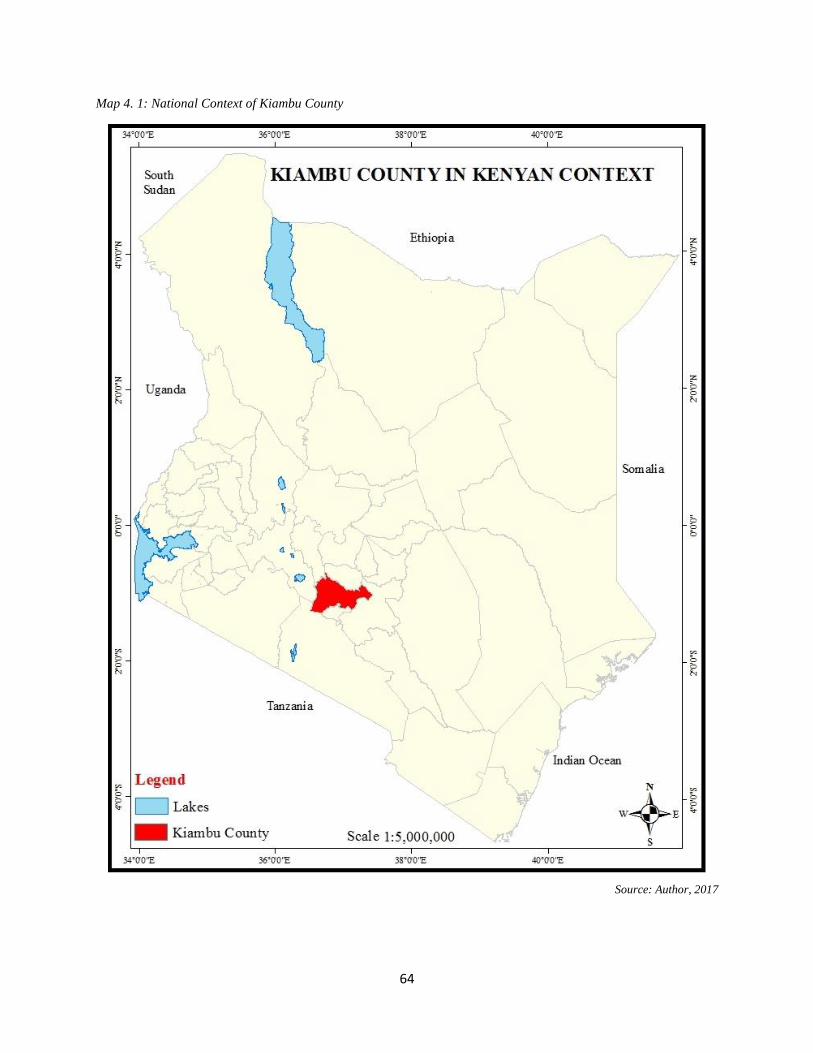
64
Map 4. 1: National Context of Kiambu County
Source: Author, 2017

65
Map 4. 2: Regional Context of Mwihoko Street in Kiambu County
Source: Author, 2017

66
Map 4. 3: Urban Context of Mwihoko Street in Ruiru Sub-County
Source: Author, 2017

67
Map 4. 4: Detailed Neighbourhood Context of Mwihoko Street
Source: Author, 2017

68
4-3 Physical and Geological features
4-3.1 Topography
Topographic features have not only affected climatic conditions of Githurai urban centre and the
entire Kiambu County, but also economic development of the area. The topography of the county
makes it viable for agricultural activities which require a ready market. The highlands to the West
form water catchments areas' and watersheds of most of the rivers, which flow towards the
lowlands of the Southeast parts of the County. The general slope of the project area, is North-West
to South-East. (GK - Nairobi Thika superhighway Report, Environmental and Social Impact
Assessment Study, Final Report, June 2007), and has an average elevation of 1,550 m above sea
level. Drainage is a problem in some sections of the market centre, more so areas that are next to
the banks of Kiu River. Also along Mwihoko street and within the centre itself, the drainage system
has not been put in place to drain away rain floods.
4-3.2 Geology and Soils
Geology and soils of a place influences the building structures that can be put up in an area. The
soils can influence the depth of the building foundation and therefore, the cost. The geology of the
study area comprise of Phonolites of middle Pliocene rocks which cover the extent between the
Nairobi national park and Kiambu, and resting directly on the Athi river. They are found 2-3 feet
below the ground. Within the study area, black cotton soils with calcareous and non-calcareous
variants are dominant of approximately 2-3 feet deep, and surface water is abundant.
4-3.3 Hydrology
It is important to understand the hydrology of a place since one will be able learn about available
water sources that can sustain the place. In the study area, the highlands to the West form water
catchments areas' and watersheds of most of the rivers, which flow towards the lowlands of the
South-East parts of the larger Githurai. The natural drainage within the project area is dictated by
the Kiu River which flow from the Kikuyu slopes, that is, to the North-West of the study area, and
flow South-East wards, forming a tributary of Athi River, which eventually flows into the Indian
Ocean. Its waters are polluted, and the source of pollution is thought to come from human
settlements along it, and urban centres, Githurai being the main one, and all these pollution is
drained through the Athi River system. Therefore, residents depend on water supplied by NWSC
– which is unreliable. They therefore depend on water from shallow wells, and from water vendors.

69
4-3.4 Vegetation
Vegetation of a place influences the climate and therefore, in the case the study area, determines
the condition under which traders work. Vegetation of the study area, generally comprises of
grassland characteristic of savannah and scattered tree species. Human activities have affected the
natural vegetation in this area, the only ones found, are the ones in the outskirts of the main market
centre along the nearby rivers and those planted by plot owners to mark plot boundaries.
4-4 Climatic Characteristics
Rainfall
Figure 4. 1: Rainfall Graph
Source: http://en.climate-data.org
Rainfall is bimodal with long rains occurring in the months of March – May, while the short rainy
period occur in the months of October – December. The mean annual rainfall is like that of Nairobi,
which range between 800 mm and 1,300 mm per annum. Precipitation is the lowest in July, with
an average of 13 mm. In April, the precipitation reaches its peak, with an average of 170 mm.
Between the driest and wettest months, the difference in precipitation is 157 mm.
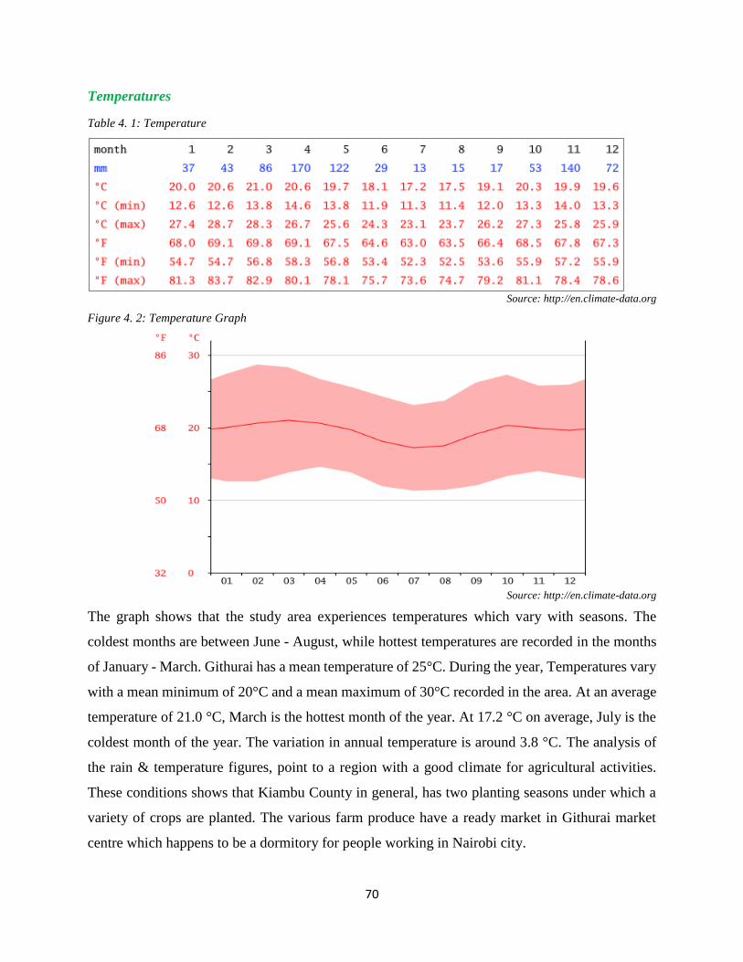
70
Temperatures
Table 4. 1: Temperature
Source: http://en.climate-data.org
Figure 4. 2: Temperature Graph
Source: http://en.climate-data.org
The graph shows that the study area experiences temperatures which vary with seasons. The
coldest months are between June - August, while hottest temperatures are recorded in the months
of January - March. Githurai has a mean temperature of 25°C. During the year, Temperatures vary
with a mean minimum of 20°C and a mean maximum of 30°C recorded in the area. At an average
temperature of 21.0 °C, March is the hottest month of the year. At 17.2 °C on average, July is the
coldest month of the year. The variation in annual temperature is around 3.8 °C. The analysis of
the rain & temperature figures, point to a region with a good climate for agricultural activities.
These conditions shows that Kiambu County in general, has two planting seasons under which a
variety of crops are planted. The various farm produce have a ready market in Githurai market
centre which happens to be a dormitory for people working in Nairobi city.
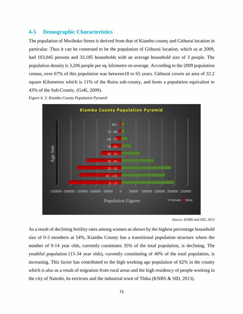
71
4-5 Demographic Characteristics
The population of Mwihoko Street is derived from that of Kiambu county and Githurai location in
particular. Thus it can be construed to be the population of Githurai location, which as at 2009,
had 103,045 persons and 33,185 households with an average household size of 3 people. The
population density is 3,206 people per sq. kilometre on average. According to the 2009 population
census, over 67% of this population was between18 to 65 years. Githurai covers an area of 32.2
square Kilometres which is 11% of the Ruiru sub-county, and hosts a population equivalent to
43% of the Sub-County. (GoK, 2009).
Figure 4. 3: Kiambu County Population Pyramid
Source: KNBS and SID, 2013
As a result of declining fertility rates among women as shown by the highest percentage household
size of 0-3 members at 54%, Kiambu County has a transitional population structure where the
number of 0-14 year olds, currently constitutes 35% of the total population, is declining. The
youthful population (15-34 year olds), currently constituting of 40% of the total population, is
increasing. This factor has contributed to the high working age population of 62% in the county
which is also as a result of migration from rural areas and the high residency of people working in
the city of Nairobi, its environs and the industrial town of Thika (KNBS & SID, 2013).
-250000 -200000 -150000 -100000 -50000 0 50000 100000 150000 200000 250000
0 - 10
10 - >20
20 - 30
30 - 40
40 - 50
50 - 60
60 - 70
70 - 80
80+
Population Figures
Age
Set
s
Kiambu County Population Pyramid
Female Male

72
Table 4. 2: Population of Githurai location
Sub-Loc Male Female Total Households
Area
in
Km2
Density
Kiuu 23,169 23,182 46,351 14,835 4.9 9,459
Mwihoko 5,909 6,025 11,934 3,238 25.8 463
Mwiki 21,609 23,151 44,760 15,112 1.5 29,840
Source: KNBS 2009
Mwiki and Kiu are the abutting neighbouring sub-locations to Githurai market centre, and are
approximately 0-1.5km from Githurai turn off towards Mwihoko estate - the furthest end in
Githurai location. From the table above it can be seen that Mwiki and Kiu sub-locations have the
highest population, households, and density. This population depends on Mwihoko Street to access
Githurai market centre for various services, as well as connecting to the city through Githurai bus
terminus, hence leading to a big number of Pedestrians seen in Githurai. It is anticipated that the
population of Githurai and its environs will continue to increase over the years to come. This future
population growth can be projected using the formula below:
Pt = Po (1+r)t
Where: P0 = Starting population
Pt = Total Population after time t (years)
r = Annual rate of growth
t = time in years
Table 4. 3: Population projection per sub location in Githurai location
Sub-Location 2,009 2,015 2,020 2,025 2,030 2,040
Kiu 46,351 53,753 60,817 68,809 77,851 88,081
Mwihoko 11,934 13,840 15,659 17,716 20,044 22,678
Mwiki 44,760 51,908 58,729 66,447 75,178 85,057
Source: Author 2016
This population projection indicates that there is an expected increase on road users of Mwihoko
Street. This will give the traffic conflicts room for further manifestation along this Street and
necessitates spatial interventions.

73
The day time population is about 50% higher than the night population due to the high number of
people who reside in the nearby estates but work in Githurai. With the upgrading of Thika Super
Highway that has reduced travel time from Nairobi City to Githurai from approximately 1 and ½
hours to only 30 minutes, most commercial activities have set base in Githurai, resulting to
increased population. Thus, there is an additional group of people who visit the market centre
during the day time to shop and visit various offices or banks.
4-6 Socio-Economic Characteristics
Mwihoko Street is supported by various economic activities that have flourished in the area, and
has seen many new buildings come up. Major economic activities within the study area include:
the Open air market which majorly deals with agricultural produce from small scale farmers in
Kiambu County and the larger Central Kenya region. Some of the farm produce sold here include:
kale, milk, poultry products like eggs, chicken and many more. Also some farm produce come
from places as far as Tanzania, where onions and fruits originate from.
Once these produce are brought to the market, they are then sold to small retailers who hawk them
within Githurai and neighbouring estates. Other economic activities include: supermarkets
(Kassmatt, G-Matt, Stanmatt, Nairobi matt); those dealing with apparels - second hand clothe
(mitumba), second hand shoes sellers; and green groceries - all operating within the road reserve;
several meat butcheries operating from the semi-permanent structures which have encroached the
road reserve. The construction industry is another sector that is supporting the economy of Githurai
in that many residents are earning their living through this industry and its linkages. Several
banking institutions have also set foot within Githurai and include: Cooperative, Family, equity
and Post bank. The growth of the greater Nairobi region and improved infrastructure and services
has led to new residential estates and significant retail trading operations.
4-7 Social Infrastructure
4-7.1 Education Facilities
There are a number of educational facilities within the larger Githurai centre whose pupils depend
on Mwihoko Street in one way or another. Some pass there as pedestrians on their way to and
from school. Others pass there as passengers while using their school buses. Therefore, they are
directly affected by what happens along Mwihoko Street. Some of these schools include: Mwiki
74
primary which is approximately 1km from the study. This is the only public primary school in
Githurai 45 area. As such, it has a high pupil population and this factor has made many parents to
look for schools in the neighbouring estates like Kahawa Garrison which has a public school. Most
of the other schools within the study area, are privately owned and are very expensive. Such
include: Lilly Academy, Excel Academy, Brainstone Academy, Juter Academy, Mary Mother
Queen primary school, Fountain Junior Academy and many others.
Generally, there is no secondary school within Githurai centre, although there are a number of
driving schools. These driving schools have offices but do not have parking space for their
vehicles, and thus end up parking in undesignated areas. There are also a few upstarting computer
training schools in Githurai that are cashing in on the many school leavers in need of computer
skills. Such students are usually inconvenienced by the disorder experienced along Mwihoko
Street.
4-7.2 Health Facilities
There are no public health facilities within Githurai area. Those in need of public health services,
have to travel to Ruiru, Thika, Kiambu or even Nairobi city. The only alternative for those who
cannot endure the distance, are the many private hospitals, clinics and chemists that serve those
who can afford to pay the exorbitant fees charged. Many of them are situated in buildings that
front Mwihoko Street and they operate from single rooms, which are squeezed, and unworthy to
offer health services. Therefore, the lack of an affordable health facility may proof to be a
challenge to those exposed to the environmental challenges such as filthy environment of dirty
drain water and uncollected garbage that is the norm.
4-7.3 Recreation Facilities
There are no public open spaces within Githurai that may be used for recreational purposes. This
may be attributed to the haphazard development that has taken place, whereby such facilities were
not considered. Due to such absence, children staying along Mwihoko Street play on the
carriageway, with accidents becoming a normal occurrence. Githurai has a bustling nightlife and
modern recreation centres for grownups, with many drinking joints where they pass their leisure
time. Most of these joints are located within residential areas and do not have parking space for
their patrons, who then end up parking along Mwihoko street thus interfering with the smooth flow
of traffic and pedestrians.

75
4-8 Physical Infrastructure
4-8.1 Road and Railway Transport
Githurai market Centre is served by two major transport corridors: Thika super highway and the
railway line connecting Nairobi and Nanyuki, plus other feeder roads which link the market to
other estates. The major artery is Mwihoko Street which is a single carriageway. Mwihoko road
is the one that is used by matatus, motorcycles, and tuk tuks to ferry residents from neighbouring
places to Githurai bus stage, en-route to other destinations. Private vehicle owners from
surrounding estates also use Mwihoko Street to access Thika super highway. The modernization
of Thika super highway has attracted many residents who own vehicles and this has led to
congestion along this main artery.
The railway line is used by a commuter train that provides both passenger and goods services on
a daily basis from Nairobi city through Umoja – Dandora - Githurai and ends up in Ruiru town.
There are two passenger trains in the morning and in the evening. In morning hours, the first one
passes at 6 AM and the second one at 7 AM. In the evening, the first one arrives at 6 PM and the
second one at 7 PM. This line basically links Githurai with industrial area, and city Centre where
majority of its commuters work. Since it provides a direct link to work places, many people prefer
this mode than road in that it safes both time and money. Thus it serves commuters from as far as
Githurai 44, who work in the direction of industrial area. These passengers usually use Mwihoko
street to access the railway termini and there are inconvenienced by the problem of disorder.
4-8.2 Water and Sewerage
Rapid unplanned growth and informal settlement fuelled by Nairobi’s urban sprawl, have put high
pressures on the capacity of Githurai’s water infrastructure to provide water services. While piped
water is still a major source of water supply in Githurai, residents access multiple sources to collect
water for household use. The major water suppliers in Githurai are the Athi Water Services Board
(AWSB), the Nairobi Water and Sewerage Company (NWSC) and private borehole operators,
which supply both through piped connections and water kiosks. Rainwater harvesting, door-to-
door vending, private wells and the rivers are also used. Generally, it can be said that
approximately 75% of water consumers in Githurai are well supplied. Githurai 45 is usually faced
with water pipe breakage and as a result water vendors cash in on the water scarcity by buying
water from Githurai 44 side and then sell to residents of Githurai 45.

76
Githurai’s lack of sanitation facilities creates a public health threat. There is no sewer system to
meet the needs of the growing population. Septic tanks and wells have been dug in the absence of
government oversight and without consideration for public health outcomes. Pit latrines or septic
tanks are often too closely spaced to shallow wells, and therefore a risk to contaminating the water
supply. In most cases septic tanks once full overflow into open storm drains that ends up polluting
the open drains that empty to Kiuu River. There were plans of constructing a sewer line, and the
tender given to a Chinese company, but due to non-involvement of residents in planning, they
petitioned their Member of Parliament (Hon. Alice Gathogo) for the project to be stopped since it
was going to dislocate some of them. The sewer line was intended to connect with Kiu - Dandora
sewer line, which serves Kahawa Sukari area. Therefore, the filthy open drains may have healthy
consequences through the infection of farm produce that are hawked along Mwihoko Street.
4-8.3 Solid Waste System
Poor solid waste disposal and collection is a major problem in Githurai. Kiambu County provides
collection service that are not adequate. The workers do their work in the morning, but since there
are few collection trucks, much of the waste is thrown into storm drains where they end up
blocking the smooth flow of dirty water forcing it to drain onto the walkways. Also the county
workers are usually overwhelmed by the amount of waste produced by the large number of traders
within the study area. The traders treat their area of operation as a space for commons, and so do
not mind where the waste they produce ends up.
4-9 Legal Framework Guiding Street Functionality
4-9.1 Kenya Constitution, 2010
The constitution under Article 43 - Economic and social rights; outlines various rights that the
citizens are entitled to, despite their social status as well as their physical challenges. Section (b)
outlines the right to accessible and adequate housing, and to reasonable Standards of sanitation;
while 43(c) refers to the right to be free from hunger, and to have adequate food of acceptable
quality. These two sections basically mean that the government should directly provide the fore
mentioned rights, or it should provide an enabling environment under which the citizens can work
comfortably to earn an honest living that will enable them to achieve those rights. Thus, provision
of a proper functioning street makes the movement of goods and services easier and cheaper to the
residents. Therefore, for a street corridor to adhere to this provision, it should provide for all the

77
road users, thus achieve economic rights to the informal sector entrepreneurs and hence right to
the urban economy.
The Constitution under various articles {e.g. 69(d), 118(b), 196(b)} provides for public
participation in the development process and decision making. Therefore at all stages of designing
a proper street that can accommodate various informal activities, public participation should be
adhered to.
4-9.2 Traffic Act, 2012
The Traffic Act, 2012 outlines penalties to any road user who violates the law. The violations
includes causing death through reckless or dangerous driving, Unauthorized driving of a public
service, Overlapping, driving on pavements and pedestrian walkways or using petrol stations to
avoid traffic, and over speeding. Also it takes care of motor cycle operator whereby he should ferry
one passenger only and the passenger and rider must be in reflective vests and helmets. The above
offences contribute to street space use contestation that may lead to accidents as well as loss of
lives. If the road users observe them then minimal occurrences of space use contestation will be
witnessed.
4-9.3 Urban Areas and Cities Act, 2011
The Urban Areas and Cities Act, 2011 gives effect to Article 184 of the Constitution of Kenya,
2010. The Act provides for: the classification, governance and management of urban areas and
cities; the criteria for establishing urban areas and; the principle of governance and participation
of residents in the governance of urban areas and cities.
The Urban Areas and Cities Act, 2011 under Part V, proposes preparation of an Integrated
Development Plan for proper management of urban centres. More specifically, in section 36(1) it
states that, every city and municipality established under this Act shall operate within the
framework of integrated development planning which shall - (e) Nurture and promote
development of informal commercial activities in an orderly and sustainable manner. Thus, any
plan to be prepared for Githurai market centre, will have to be in line with what the Act states.
4-9.4 County Government Act, 2012
The Distribution of Functions between the National Government and the County Governments are
outlined in the 2010 Kenya Constitution under the Fourth Schedule (Article 185 (2), 186 (1) and
187 (2)). Some of the functions and powers of the county Governments include:

78
County transport: (a) County roads (class D and below), (b) Street lighting, (c) Traffic and
parking, (d) Public road transport, and (e) Ferries and harbours, excluding the regulation of
international and national shipping and matters related thereto.
County planning and development, including; (a) statistics, (b) land survey and mapping, (c)
boundaries and fencing, (d) housing; and (e) electricity and gas reticulation and energy
regulation.
Trade development and regulation, including; (a) Markets, (b) Trade licences (excluding
regulation of professions), (c) Fair trading practices, (d) Local tourism, and (e) Cooperative
societies which imply that county system will be instrumental in resource allocation and
planning for the development of SMEs in Kenya..
The current state of affair in Githurai centre shows a state of neglect on the part of the County
government whereby it seems to be detached from the activities taking place there. The county
government has started implementing what is outlined in the 2010 Kenya Constitution. Therefore,
in coming up with a well-designed plan that will integrate all activities in the study area, reference
will be made to the above functions. The county government will come in handy during the
implementation and development control stage.
4-9.5 Way -Leave Act (Cap 292)
Conferring to Section 3 of the Act, the Government may carry out any works through; over or
under any land whatsoever, provided it shall not interfere with any existing building or structure
of an ongoing activity. Notice, however, should be given one month before carrying out any such
works (Section 4). This Notice shall additionally be accompanied by full description of the
intended works and targeted place for inspection. Any damages caused by the works would then
be compensated for to the owner.
Section 8 of the Act states that any person whom without consent causes any building to be nearly
erected on a Way-Leave, or cause hindrance along the Way-Leave shall be guilty of an offence
and any alternations will be done at his/her costs. Along Mwihoko street various structures have
encroached on the road reserve which might be impacted upon during expansion stage. For those
who have obstructed the right of way, prior notice should be served on the intention to demolish
them, while those who will be required to ease their land, compensation will be provided.
79
4-9.6 Environmental Management and Coordination Act, 1999
The EIA (Environmental Impact Assessment) Regulations are meant to operate under Section 58
of EMCA. It makes it illegal for anyone to undertake developments without an EIA license. All
development projects ought to be economically viable, socially acceptable and environmentally
sound. It is a condition to conduct Environmental Impact Assessment on development Projects.
EIA assesses the impacts of a proposed project before commencement of implementation. In
addition to helping formulate proper development policy, EIA provides for public participation in
the decision making process in respect of a given proposed project. EIA serves the following
purposes: Integration of environmental issues into planning and decision making processes;
Anticipation, minimization and mitigation of environmental damage and recommendation of
alternatives; and Public participation in decision making and environmental conservation.
The Act has identified several projects which require an EIA to be done before they are started.
Some of these projects are of the built environment category including construction of: - all
buildings; all major roads; all roads in scenic, wooded or mountainous areas and wetlands;
Railway lines; Airports and airfields; Oil and gas pipelines; and Water transport. Also in case of
creating a new settlement, EIA is required to find out the negative impacts that may result from
bringing people to such an area. Settlement here, may refer to setting aside land within an urban
area to locate informal sector activities. Sometimes such an area may be ecologically sensitive and
so may not be suitable to hold such activities. Thus, even Mwihoko street in the process of it being
upgraded should undergo an EIA to find whether proper drainage is provided for, and that sites
selected to accommodate informal activities are conducive and not ecologically sensitive.
4-9.7 National Transport and Safety Authority Act (NTSA), 2012
National Transport and Safety Authority Act, 2012, touches on various areas that are relevant to
informal sector activities as outlined below:
The NTSA (Operation of motorcycles) Regulations, 2014; outlines some of the responsibilities
of a Rider as being: Have a valid driving license issued by the Authority; Not carry more than
one person at a time; Ensure that loads and passengers are not carried at the same time; Not
park in undesignated areas.
In the case of Operation of Three Wheeled Motorcycles: Every rider of a three wheeled
motorcycle shall: Not ride a motorcycle unless that person has a valid driving licence issued
80
by the Authority; To overtake on the right hand side and not to overtake in the same lane
occupied by vehicle being overtaken; Not to ride or operate a motorcycle between lanes of
traffic or between adjacent lines or rows of vehicles; To observe all traffic rules.
But it seems the NTSA regulations are being flouted along Mwihoko street given the fact that the
mentioned operators are not following them. This is exacerbated by the fact that there are no traffic
officers manning this street.
4-10 Policy Framework Guiding Street Functionality
4-10.1 Vision 2030, Kenya
In the Kenya Vision 2030, six priority sectors have been identified as having the highest potential
for economic growth. These sectors are: tourism, agriculture, manufacturing, wholesale and retail
trade, business processing outsourcing and financial services. However, to exploit the growth
potential from these sectors, it is necessary to improve the infrastructure in areas that best support
these growth engines, in addition to implementing key reforms in the public sector. Vision 2030
envisages a country firmly interconnected through a network of roads, railways, ports, airports,
waterways and telecommunications. The 2030 vision for infrastructure is; “To deploy and employ
cost-effective world-class infrastructure facilities and services in support of socio-economic development”
On Poverty reduction, and reduced income disparities, the objective under this thrust is to reduce
inequality in access to public services and income opportunities across gender, social status and
regions. The specific goal is to reduce the national poverty ratio from the current 46 per cent to a
range of between 30 and 35 per cent by 2012. A key strategy towards attaining this goal is to target
more income-earning opportunities for disadvantaged groups and regions in the six growth sectors
of tourism, agriculture, wholesale and retail trade, manufacturing, Business Process Out-sourcing
/ Offshoring (BPO) and financial services. There will also be increased infrastructure spending in
the sub-sectors of roads, water, sewerage, communications, electricity and lighting targeting poor
communities and regions. These measures will be aimed at creating an enabling environment for
poor communities to take part in wealth creation for themselves and their country.
Specifically the informal sector is dealt with under the Economic Pillar in the subsection of
Wholesale and retail trade. The 2030 vision for wholesale and retail trade, is to raise earnings by
giving our large informal sector opportunities to transform itself into a part of the formal sector
that is efficient, multi-tiered, diversified in product range and innovative. This will be realised

81
through: (i) training and credit (ii) improving efficiency by reducing the number of players
between the producer and the consumer; (iii) creating formal market outlets for small scale
operators who will then graduate from the informal sector; (iv) encouraging more investment in
retail trade; (iv) developing an outreach programme to expand retail trade; and (v) developing
training programmes to improve retail skills.
From the specific goal of the vision (reducing national poverty) and key strategy towards attaining
this goal (targeting more income-earning opportunities for disadvantaged groups), it can be seen
that the vision augurs well for those involved in the informal sector along Mwihoko street. This is
true given that the informal activities they are involved in, is a self-venture that is a source of
income since white-collar jobs have become scarce. Therefore the vision needs to be implemented
so as to streamline the activities along Mwihoko street. This can be implemented through the
provision of training opportunities and credit facilities to those in the informal sector operating
along Mwihoko street, and also provision of planned vending sites.
4-10.2 Integrated National Transport Policy (2012)
The aim of this document is to provide a policy that is conducive to the stimulation of rapid
development and efficient management of a safe, widely accessible transport system that responds
to modern technological advancement in a rapidly changing and globalized environment (INTP
2009 page, 20). It points out that the road transport sector‘s main aim is to provide an integrated,
efficient, reliable and sustainable road transport infrastructure that meets national and regional
passenger and freight transport goals and supports the government‘s socio-economic development
strategies to promote accessibility to services and the safe movement of people and goods, while
being environmentally and economically sustainable. But in its institutional framework it does
not provide for people in charge of planning for the infrastructure in relation to the accompanying
land uses. Still it has no clear measures to coordinate its institutions with the national and county
planning departments.
The aim of this policy is noble in that it intends to respond to modernity, where infrastructure is
supposed to serve multiple users rather that a single user. Given the challenges experienced along
Mwihoko street, the County government of Kiambu can work in conjunction with the National
government to come up with a street design that will satisfy all users, with those in the informal
sector included.

82
4-10.3 The National Urban Development Policy (2012)
The National Urban Development Policy is part of the Government’s efforts to implement the
provisions on urban development contained in the Constitution, particularly in Article 176 and 184
dealing with devolution, classification and management of urban areas, including popular
participation. This policy recognizes that Kenya has cities and towns. It is the one that gave birth
to the enactment of Urban Areas and Cities Act, 2011.
This policy was prepared due to the expected demographic, social and economic changes that will
be brought about by urbanization. It aims to strengthen development planning, urban governance
and management, urban investments and delivery of social and physical infrastructure in urban
areas throughout the country. The long-term goal of the Policy is to accelerate economic growth,
reduce poverty, promote equity and help the nation realize Vision 2030, which aims to make Kenya
a middle-income country within two decades. The Policy also responds to the Constitution of
Kenya 2010 that calls for devolved governance at the county level and to the Urban Areas and
Cities Act 2011, which was enacted to comply with this requirement.
According to Nabutola (2012), Social infrastructure and services are critical to the development of
sustainable urban communities. However, urban areas in Kenya have in the past failed to provide
the requisite social infrastructure and services. The Policy creates a framework for the planning,
development and management of education and health facilities, and public open spaces, parks
and recreational facilities, including but not limited to sports amenities. Cities and urban areas are
also characterized by poor physical infrastructure and services, making it difficult to deliver
competitive and liveable cities. The Policy has prioritized planning and development of the much-
needed physical infrastructure and services for sustainable urbanization. In addition, in the face of
rapid urbanization, informal settlements have come to epitomize housing in urban areas cities. On
average, informal settlements cater for 60% of the total urban population. In response to fast
growing demand for appropriate urban housing the Policy recommends mechanisms to deliver
affordable housing of acceptable quality.
Cities and urban areas have witnessed a rising incidence of insecurity. Yet urban safety is critical
for the realization of sustainable urban communities. In order to better manage urban insecurity
this Policy creates a framework for the engagement of various stakeholders in urban safety
management. Moreover, in view of the increasing exposure of urban areas and cities to the threat

83
of disaster, with the potential to cause massive loss of life and property, the Policy creates
structures for mainstreaming disaster risk management in urban planning and development. In
compliance with the constitutional provision on marginalized and vulnerable groups, the Policy
requires urban authorities to take necessary measures to mainstream the needs and concerns of
these groups in planning and development. The policy also addresses cross-cutting issues and the
key elements of an implementation framework.
On poverty and economic empowerment, the policy recognizes that the marginalised and
vulnerable groups in urban areas face high unemployment levels. They have inadequate
opportunities in education and the urban economy, in addition to having poor access to health and
sanitation facilities. To address these disadvantages, it proposes that the National and County
governments will: Promote poverty reduction strategies; Promote incentives to encourage
employment of the marginalised and vulnerable groups in urban areas and cities; promote
programmes that encourage marginalised and vulnerable groups to engage in productive economic
activity; and lastly, promote awareness of existing urban policies to empower the marginalised
groups.
This policy expects the county government of Kiambu to create an enabling environment along
Mwihoko street for the informal sector to thrive, while at the same taking care of other street users
competing for space. They may do this by implementing the Urban Areas and Cities Act, 2011
that requires management of urban areas to be under town management committees for easier
response to local needs that require quick decisions.
4-10.4 Physical Planning Handbook
Under the Physical Planning Order, 1998 Part II; the handbook proposes that: No development
shall be carried out which creates an obstruction to the view of persons using any road used by
vehicular traffic at or near any bend corner, junction or intersection of any roads so as to be likely
to cause danger to such persons. It also proposes that no part of any building shall project beyond
any building line laid down for the holding or plot.
The Physical Planning Handbook (2007) section 13.1.3, states that: Urban road reserves require
more generous space provision because of additional street furniture and infrastructural facilities
that have to be provided. It goes further to state that in most instances, the road has to accommodate
multiple functions that have to be independently provided in design. Way-leaves for trunk services

84
such as water and sewerage, underground telephone cables and high voltage power lines, when
provided along road reserves require additional provision. It continues to state that, the role of the
informal sector in job creation in urban areas has now been recognized. Most of the informal
activities are footloose and heavily dependent on passing trade. They therefore require specific
provision when located within road reserves. As such, the handbook is a good reference when
ordering activities along Mwihoko street.
PPH takes cognisance of the fact that the informal sector is a critical part of the economy which
absorbs a big number of people, and since these activities take place at crossroads that are
synonymous with big traffic, they therefore require to be planned for. The PPH aspires that any
road improvement should take cognisance of the users. Thus in the case of Mwihoko street, the
improvement should be done in such a way that the design accommodates all the street users with
informal activities included.
4-11 Conclusion
In conclusion, literature on site analysis has shown that Githurai urban centre is uniquely located.
It’s location at the periphery of Nairobi city, and the fact that rents are cheaper, has attracted many
people working in Nairobi who have converted the centre into a dormitory. The presence of this
large population has in turn attracted many informal traders who have found a ready market. The
study has further shown that the good climatic conditions within Kiambu County and other
surrounding areas, are favourable for agriculture activities and residents have taken full advantage
of this. And Githurai urban centre with its large population has turned out to be a resourceful
market for their farm produce. From the fact that land set aside for an open air market has
continued to shrink over the years with the over expanding number of informal traders, there has
been an overflow of these traders to other spaces resulting to inconveniencing many residents.
Therefore this calls for proper urban planning and design to re-organise and integrate this sector
into the urban system.

85
CHAPTER 5: SPACE USE CONTESTATION ON MWIHOKO STREET
5-1 Introduction
The study’s main aim was to assess the implications of urban street space use contestation by
informal activities, while a subsidiary aim of the research was to propose better planning
approaches that can mitigate/mediate the space contestation. This chapter examines the study’s
objectives 1, 2 and 3. Data collection during field survey was done using: observations – visual
characteristics of study area recorded on maps & observation forms, administration of survey
instruments – questionnaires & interviews for key informants. Descriptive statistics has been
presented using table, bar chart and pie charts as Mugenda (1999) states; - they are good for
descriptive variable. Interpretive analysis follows each descriptive statistics.
5-2 Major Activities Located Along Mwihoko Street
This section intends to assess and map major activities located along Mwihoko Street in Githurai,
and also note the areas that have been affected by space use contestation.
5-2.1 Activity Types
The study found that Mwihoko Street is home to a number of land uses that are located along its
sides. The buildings go up four -to- five floors, meaning that they are of high density and therefore
serve many people. Unfortunately, they are served by septic tanks for sewer disposal, given that
there is no sewer line in the area. The residents of this area rely on Mwihoko Street as the main
artery to access Thika superhighway. These buildings comprise of a mixture of business cum
residential usage consisting of 4-5 floor (see Plate 4.1). Some buildings are purely commercial in
terms of the activities being undertaken there. Such activities include; supermarkets, night clubs
and bars; restaurants, banks and SACCOs.
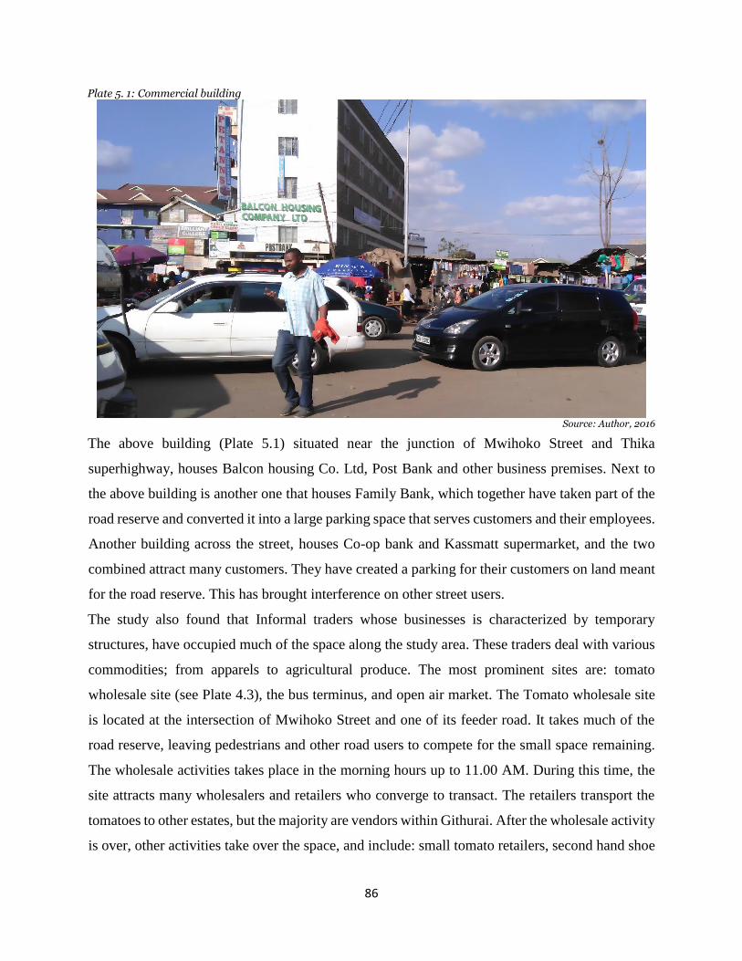
86
Plate 5. 1: Commercial building
Source: Author, 2016
The above building (Plate 5.1) situated near the junction of Mwihoko Street and Thika
superhighway, houses Balcon housing Co. Ltd, Post Bank and other business premises. Next to
the above building is another one that houses Family Bank, which together have taken part of the
road reserve and converted it into a large parking space that serves customers and their employees.
Another building across the street, houses Co-op bank and Kassmatt supermarket, and the two
combined attract many customers. They have created a parking for their customers on land meant
for the road reserve. This has brought interference on other street users.
The study also found that Informal traders whose businesses is characterized by temporary
structures, have occupied much of the space along the study area. These traders deal with various
commodities; from apparels to agricultural produce. The most prominent sites are: tomato
wholesale site (see Plate 4.3), the bus terminus, and open air market. The Tomato wholesale site
is located at the intersection of Mwihoko Street and one of its feeder road. It takes much of the
road reserve, leaving pedestrians and other road users to compete for the small space remaining.
The wholesale activities takes place in the morning hours up to 11.00 AM. During this time, the
site attracts many wholesalers and retailers who converge to transact. The retailers transport the
tomatoes to other estates, but the majority are vendors within Githurai. After the wholesale activity
is over, other activities take over the space, and include: small tomato retailers, second hand shoe

87
sellers, chicken sellers, mama mbogas, fruit sellers, and furniture dealers. The following plates
illustrate this:
Plate 5. 3: Tomato wholesale site
Plate 5. 5: Users contesting for space
Source: Author, 2016
The study area is dotted with wooden temporary structures from where street vendors operate.
They deal mostly in agriculture produce like; fruits vegetables, and apparels. There are others,
involved in manicure and pedicure activities along the street sides. There are also street vendors
Plate 5. 2: Small scale retailers along the street
Plate 5. 4: Pedestrians using the carriageway
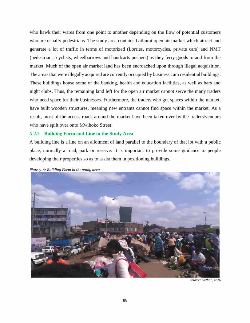
88
who hawk their wares from one point to another depending on the flow of potential customers
who are usually pedestrians. The study area contains Githurai open air market which attract and
generate a lot of traffic in terms of motorized (Lorries, motorcycles, private cars) and NMT
(pedestrians, cyclists, wheelbarrows and handcarts pushers) as they ferry goods to and from the
market. Much of the open air market land has been encroached upon through illegal acquisition.
The areas that were illegally acquired are currently occupied by business cum residential buildings.
These buildings house some of the banking, health and education facilities, as well as bars and
night clubs. Thus, the remaining land left for the open air market cannot serve the many traders
who need space for their businesses. Furthermore, the traders who got spaces within the market,
have built wooden structures, meaning new entrants cannot find space within the market. As a
result, most of the access roads around the market have been taken over by the traders/vendors
who have spilt over onto Mwihoko Street.
5-2.2 Building Form and Line in the Study Area
A building line is a line on an allotment of land parallel to the boundary of that lot with a public
place, normally a road, park or reserve. It is important to provide some guidance to people
developing their properties so as to assist them in positioning buildings.
Plate 5. 6: Building Form in the study area
Source: Author, 2016

89
The building line also provides some certainty to existing owners as to where they can expect new
buildings to be located, and thus contribute to an attractive streetscape, and preserve and promote
visual amenity. It also provides areas for landscaping. The buildings along the Street go up four -
to- five floors, and have been constructed beacon to beacon such that no service lanes exist between
them. Those fronting the street, have their balcony protruding towards the road reserve, thereby
encroaching on the area reserved for public utilities. As such, the structures have not followed any
building line.
The ground floor of most of these buildings, more so, the section facing the street, have been
subdivided into rooms of approximately 10 feet by 10 feet. Such rooms have been sublet to serve
as chemists, butcheries, beauty shops, apparels, cereal shops, hardwares, cafes and hotels,
bookshops, and electronic shops. Some of these activities like cereal shops, hardware, and apparel
shops tend to display their wares onto the space in front of the shops, and in so doing, interfere
with other street uses. In most of the buildings, only the front room facing the street are used for
commercial activities. The other rooms are let out for residential usage.
5-2.3 Places and Nature of Contestation
Problems of space use Contestation along Mwihoko Street vary depending on the time, site, and
type of activity being carried out. Movement of various users is mostly affected in the morning
and evening hours. This happens because, this is the time many people are travelling to work or
coming from work. During this time, most of the road users who include: pedestrians, boda bodas,
tuk tuks, Matatus, cart pushers, cyclists, and street vendors; struggle to reach their destination by
using Mwihoko street. Plate 5.7 illustrates a typical morning hours in the study area.
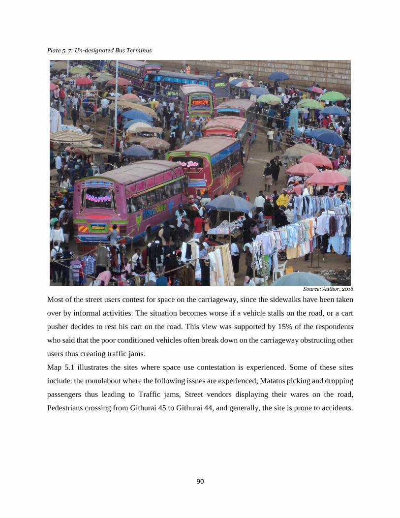
90
Plate 5. 7: Un-designated Bus Terminus
Source: Author, 2016
Most of the street users contest for space on the carriageway, since the sidewalks have been taken
over by informal activities. The situation becomes worse if a vehicle stalls on the road, or a cart
pusher decides to rest his cart on the road. This view was supported by 15% of the respondents
who said that the poor conditioned vehicles often break down on the carriageway obstructing other
users thus creating traffic jams.
Map 5.1 illustrates the sites where space use contestation is experienced. Some of these sites
include: the roundabout where the following issues are experienced; Matatus picking and dropping
passengers thus leading to Traffic jams, Street vendors displaying their wares on the road,
Pedestrians crossing from Githurai 45 to Githurai 44, and generally, the site is prone to accidents.

91
Map 5. 1: Nature and Places of Space Contestation
Source: Field Work, 2016

92
5-2.4 Mwihoko Street Design
Street exist not just for movement, but as a space that everyone shares. This means that they should
be designed in a way that serve multiple functions. The multiple functions of streets in urban areas
can be summarized as: a channel of movement, a communication space, a public space, a place of
social and commercial encounter and exchange, a place to do business, a political space and also
a symbolic and ceremonial space in the city. Thus a good street design should be one that divides
the street into various zones. These zones include; roadway zone, curb side zone, amenity zone,
and walking zones as illustrated in figure 5.1.
Figure 5. 1: Sample design street cross section
Source: Street and Site Plan Design Standards - Chicago Department of Transportation, 2007 - accessed 2016
Mwihoko street was initially planned to be 25 metres in width, but over time much of this reserve
has been encroached. The design for this street has not taken into consideration the various
functions that a well-designed street should serve. The street is a single narrow carriageway that
serves many street users, and has no separate walkways or cycle paths subjecting every mode to
use the carriageway for movement (see plates 5.4 & 5.5). The shoulders of the street have been
taken over by informal sector activities, and therefore pedestrians are forced to walk on the
roadway zone (see plate 5.4). 20% of the respondents attributed space use contest to the
inappropriate road design in the study area. This was evidenced by vehicles using part of the street
to pick and drop passengers since there is no designated stage along the street. There are also many
T junctions along Mwihoko Street whereby traffic from those feeder roads joining Mwihoko street,

93
usually obstruct traffic along Mwihoko Street. There are no traffic lights, and when there are no
police officers to direct vehicles, the movement becomes a quagmire.
5-2.5 Traffic Experience in the Study Area
Mwihoko Street is characterized by several T-junctions that feed it with traffic from residential
estates, and other land uses like educational, religious or recreational. These junctions have
witnessed an influx of informal traders who have taken over much of the streets joining Mwihoko
Street. As a result, these junctions are so narrow thus impairing corner negotiation of vehicles
joining or leaving Mwihoko Street at these points. This situation is worsened by the fact that there
are no traffic control mechanisms (traffic lights, speed pumps or traffic police officers) in place
within the study area. This impediment affects the traffic flow along Mwihoko Street since the
through traffic has to wait for the vehicles joining or leaving the street.
At the Thika superhighway- Mwihoko Street intersection, buses and Matatus have converted
sections of Mwihoko Street for un-designated bus terminus. This site is not only used by vehicles
plying Githurai route, but also by vehicles serving people of Mount Kenya region and beyond who
drop and pick passengers at this intersection. This has eased transportation services to residents of
Githurai, but has also contributed to the traffic problems, for it creates massive traffic congestion
at this intersection; leading to traffic snarl-ups along Mwihoko street to as far as 1 km away. This
congestion is felt along Thika superhighway more so, on the service lane where massive traffic
jam is experienced due to the high traffic volume on this road. Customers of farm produce and
those who come for other services in Githurai, are affected negatively.
The next junction is that heading to the open air market, where traffic ferrying goods to and from
the market pass, involving trailers, canters, handcarts, people, and wheelbarrows. This turn-off is
narrow since its sides are occupied by informal traders and thus cannot allow vehicles to access
the market easily. This usually leads to in-coming traffic piling up on Mwihoko Street to give way
to outgoing vehicles first before they can get their turn of offloading goods in the market. By
parking along Mwihoko Street, these vehicles obstruct the through traffic along Mwihoko Street
hence increasing competition for space use. The market operates on a daily basis and therefore
this is a daily occurrence along this street that is more pronounced in morning and evening hours
when goods are brought to the market.

94
The third T-junction, is the one heading to Naivas supermarket, which has been converted into a
parking lot by tuk tuks lining up to wait for their turn to pick passengers from an un-designated
bus terminus. The tuk tuks use this junction as an entry and exit to Mwihoko Street, causing
massive jams along Mwihoko Street. With the fact that sides of this adjoining street are occupied
by street vendors, the space left is so narrow and therefore tuk tuks’ activities at this site have
become an impediment to the smooth movement of other street user and pedestrians included.
The last major T-junction along the study area, is the one used as a tomato wholesale market. The
market has taken both sides of this street leaving a very narrow strip to be used by other street
users. The wholesale of tomatoes takes place in the morning hours, but can go on until afternoon
depending on demand. Afterwards, the site is then occupied by small tomato retailers, apparel
dealers, chicken sellers, furniture dealers etc. all these activities impede other street users from
enjoying the use of Mwihoko Street.
5-2.6 Land Uses along Mwihoko street
Various land uses exist along Mwihoko street, namely; commercial, business-cum-residential,
public utility, light industrial (Jua kali activities), recreational, educational and many others.
Business cum residential buildings of 4-5 floors, are the majority in the study area. Commercial
land uses comprise of buildings which house formal licensed businesses, and areas with informal
small businesses characterized by temporary wooden structures.
Mwihoko street is abutted on one side by Githurai open air market which attract and generate
volumes of traffic either motorized - lorries, motorcycles, private cars; or NMT - people,
wheelbarrows, handcarts and bicycles; as they ferry goods to and from the market. Much of the
land set out for the open air market has been grabbed and business-cum-residential buildings
constructed thus encroaching on the market space, and limiting operations within it. Some of these
buildings house; driving schools, health and education facilities, as well as the bars and night clubs.
Other major facilities located along Mwihoko Street include; Kassmatt supermarket, Market club,
Co-op bank, Post bank and Family Bank - which attract and generate traffic due the nature of
services they offer while providing minimal or no parking for their customers. The surrounding
estates also generate traffic that is directed towards Mwihoko Street en-route to other destinations.
Map 5.2 illustrates Land Uses in the study area, while Map 5.3 illustrates a Cross Section
interdependency that exist between various land uses as observed at a spot next to KassMart
Supermarket and the Open air market.
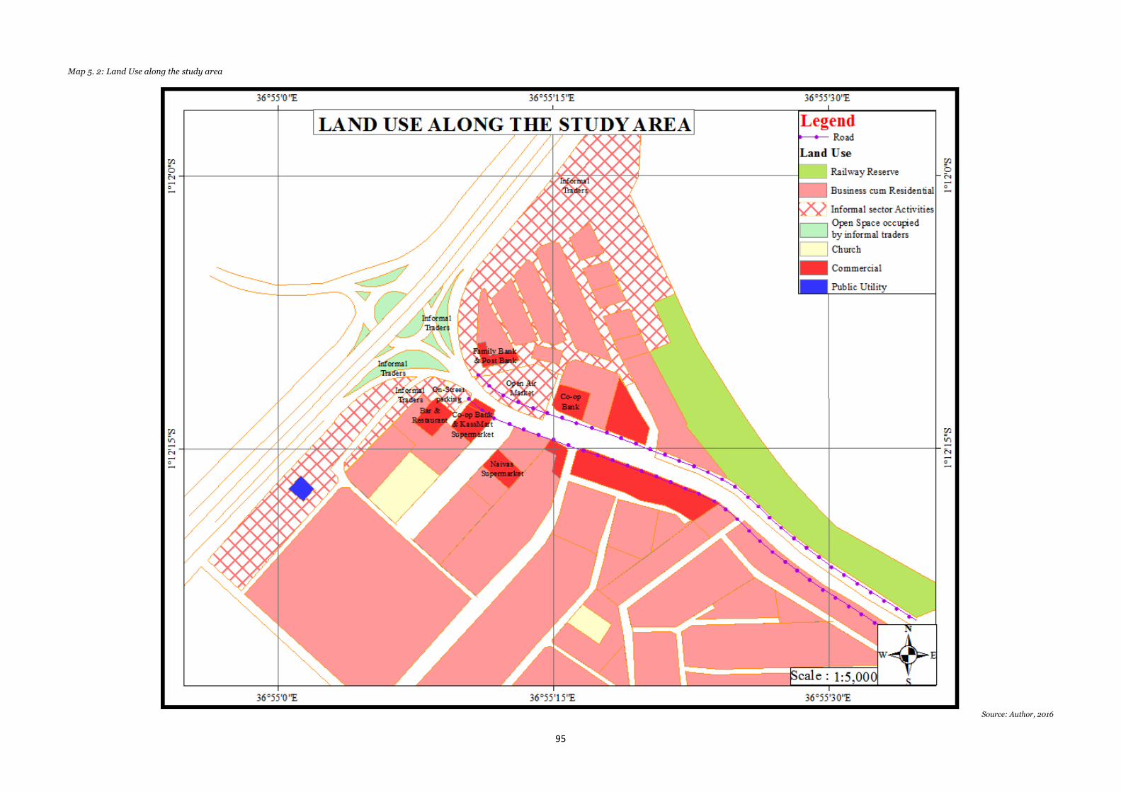
95
Map 5. 2: Land Use along the study area
Source: Author, 2016
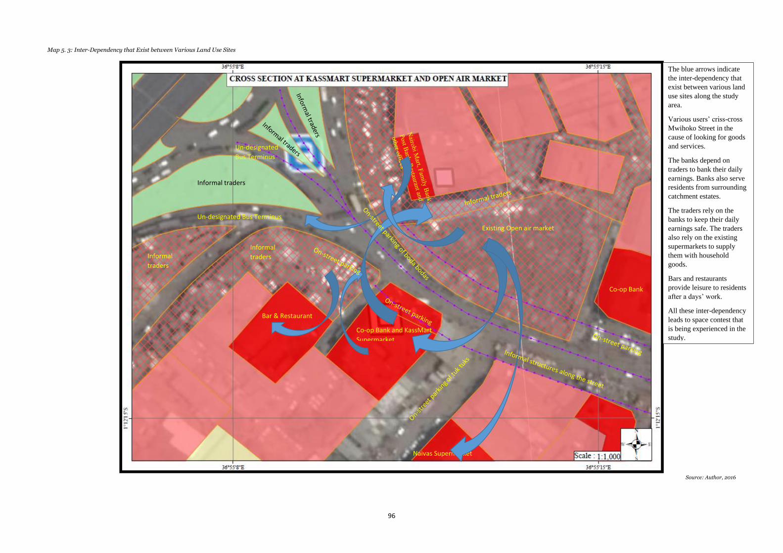
96
Map 5. 3: Inter-Dependency that Exist between Various Land Use Sites
Source: Author, 2016
Existing Open air market
Existing Open air market
Co-op Bank and KassMart
Supermarket
Co-op Bank and KassMart
Supermarket
Naivas Supermarket
Naivas Supermarket
Bar & Restaurant
Bar & Restaurant
Co-op Bank
Co-op Bank
Un-designated Bus Terminus
Un-designated Bus Terminus Informal
traders
Informal
traders
Informal traders
Informal traders
Informal
traders
Informal
traders
The blue arrows indicate
the inter-dependency that
exist between various land
use sites along the study
area.
Various users’ criss-cross
Mwihoko Street in the
cause of looking for goods
and services.
The banks depend on
traders to bank their daily
earnings. Banks also serve
residents from surrounding
catchment estates.
The traders rely on the
banks to keep their daily
earnings safe. The traders
also rely on the existing
supermarkets to supply
them with household
goods.
Bars and restaurants
provide leisure to residents
after a days’ work.
All these inter-dependency
leads to space contest that
is being experienced in the
study.
The blue arrows indicate
the inter-dependency that
exist between various land
use sites along the study
area.
Various users’ criss-cross
Mwihoko Street in the
cause of looking for goods
and services.
The banks depend on
traders to bank their daily
earnings. Banks also serve
residents from surrounding
catchment estates.
The traders rely on the
banks to keep their daily
earnings safe. The traders
also rely on the existing
supermarkets to supply
them with household
Un-designated
Bus Terminus
Un-designated
Bus Terminus
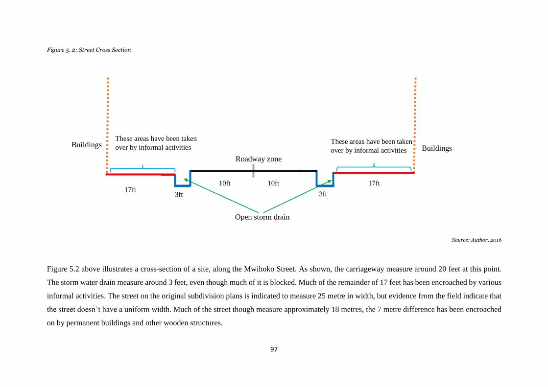
97
Figure 5. 2: Street Cross Section
Source: Author, 2016
Figure 5.2 above illustrates a cross-section of a site, along the Mwihoko Street. As shown, the carriageway measure around 20 feet at this point.
The storm water drain measure around 3 feet, even though much of it is blocked. Much of the remainder of 17 feet has been encroached by various
informal activities. The street on the original subdivision plans is indicated to measure 25 metre in width, but evidence from the field indicate that
the street doesn’t have a uniform width. Much of the street though measure approximately 18 metres, the 7 metre difference has been encroached
on by permanent buildings and other wooden structures.
17ft
17ft
3ft
3ft
10ft
10ft
10ft
10ft
3ft
3ft
17ft
17ft
Roadway zone
Open storm drain
These areas have been taken
over by informal activities These areas have been taken
over by informal activities Buildings
Buildings

98
5-3 Factors that Influence Space use Contestation a long Mwihoko Street
In order to understand the factors influencing space use in the study area, the views of the
respondents were analysed and categorized in terms of pull and push factors that make users
prefer using space along Mwihoko Street. But first, the respondents’ social- economic
characteristics are highlighted;
5-3.1 Respondents’ Social- Economic Characteristics
Marital Status
Figure 5. 3: Marital Status
Source: Field Survey, 2016
On figure 5.3, numbers on the vertical axis represent the percentages in terms of marital status,
while the horizontal axis represents different categories of respondents. The figure indicates
marital status among respondents where, 57% of the pedestrians are married with 43% being
single, while there were no cases of divorces nor widowed pedestrians. 41% of the hand carts,
tuk tuks drivers and cyclists interviewed were married with a bigger percentage of 59% being
single. Among street vendors’ 73.5% were married, and 26.5% single, with no reported cases
of divorce or widowed marital status. Figure 5.3 illustrates this. These figures brings out a
certain character within the populace. First on pedestrians, majority are married, while a good
number are single. On the part of cart pushers/cyclists, the high number of singles indicates
that this sector is dominated by the youth who cannot find other formal employment. On street
vendors, the figures indicate that the sector is dominated by people who are married and are
able to earn a living to support their own families. The ones in the single category are few,
meaning that those who join this sector are able to stabilize quickly and therefore leave the
singlehood club.
0
10
20
30
40
50
60
70
80
Pedestrians Cart pushers/Cyclists Street Vendors
%
Marital Status Married (%) Single (%)
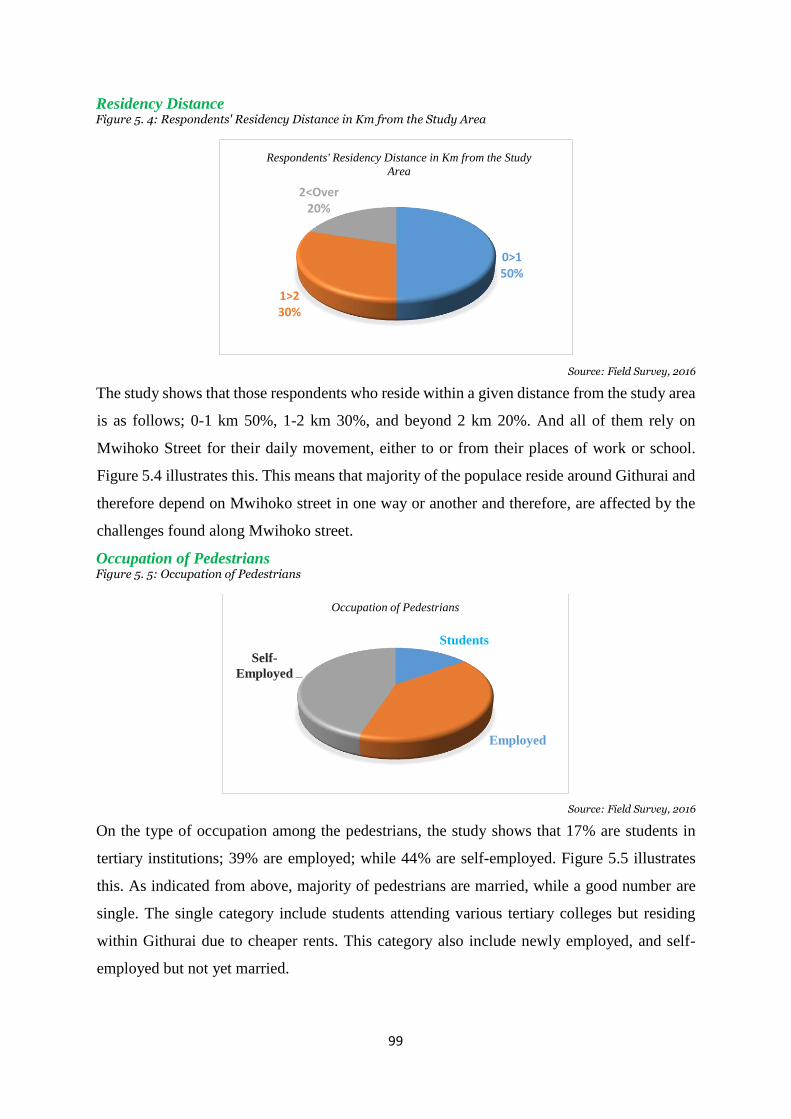
99
Residency Distance Figure 5. 4: Respondents' Residency Distance in Km from the Study Area
Source: Field Survey, 2016
The study shows that those respondents who reside within a given distance from the study area
is as follows; 0-1 km 50%, 1-2 km 30%, and beyond 2 km 20%. And all of them rely on
Mwihoko Street for their daily movement, either to or from their places of work or school.
Figure 5.4 illustrates this. This means that majority of the populace reside around Githurai and
therefore depend on Mwihoko street in one way or another and therefore, are affected by the
challenges found along Mwihoko street.
Occupation of Pedestrians Figure 5. 5: Occupation of Pedestrians
Source: Field Survey, 2016
On the type of occupation among the pedestrians, the study shows that 17% are students in
tertiary institutions; 39% are employed; while 44% are self-employed. Figure 5.5 illustrates
this. As indicated from above, majority of pedestrians are married, while a good number are
single. The single category include students attending various tertiary colleges but residing
within Githurai due to cheaper rents. This category also include newly employed, and self-
employed but not yet married.
0>150%
1>230%
2<Over20%
Respondents' Residency Distance in Km from the Study
Area
Students
Employed
Self-
Employed
Occupation of Pedestrians

100
Education Level Figure 5. 6: Education Level
Source: Field Survey, 2016
On figure 5.6, the vertical axis indicates the number of respondents in terms of percentages
who have attained a given level of education, while the horizontal axis indicates the different
levels of education. The figure indicates that 37.5% of cyclists, tuk tuks drivers and handcart
pushers have received at least basic education. And 62.5% of those groups have had access to
secondary education. Among street vendors the result shows that 13% have had primary
education, 56% have had secondary education, while 31% have had tertiary education. This
indicates that majority of street vendors are well educated since 87% of them have had
secondary education and above. Given that employment opportunities have become scarce,
they have resorted to join the informal sector in order to earn a living through informal sector.
Such a group if well supported with financial assistance and training, can easily convert their
small business into profitable ventures.
Ages of Street Vendors Figure 5. 7: Ages of Street Vendors
Source: Field Survey, 2016
0
10
20
30
40
50
60
70
Primary Secondary Tertiary
13
56
3137.5
62.5
0
Education Level
Street vendors Cyclist/Cart Pushers/Tuk tuk drivers
> 3537%
35 < 5544%
55 <19%
Ages of Street Vendors
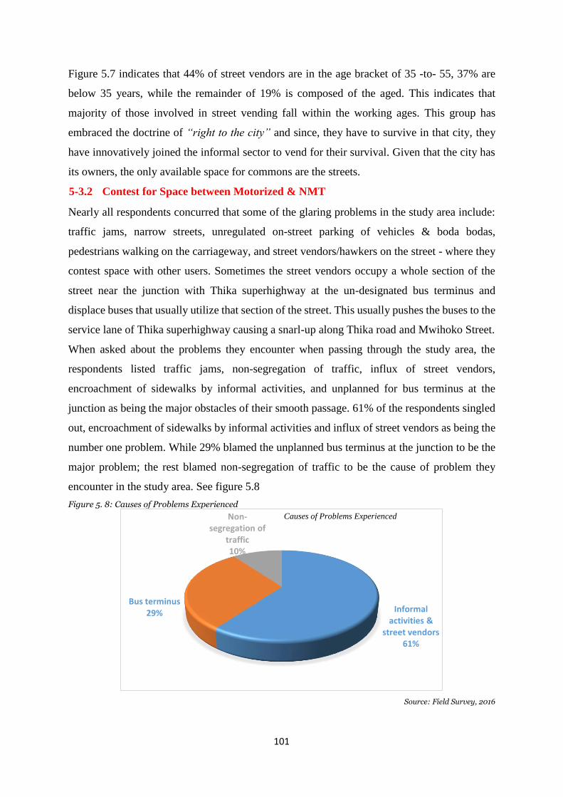
101
Figure 5.7 indicates that 44% of street vendors are in the age bracket of 35 -to- 55, 37% are
below 35 years, while the remainder of 19% is composed of the aged. This indicates that
majority of those involved in street vending fall within the working ages. This group has
embraced the doctrine of “right to the city” and since, they have to survive in that city, they
have innovatively joined the informal sector to vend for their survival. Given that the city has
its owners, the only available space for commons are the streets.
5-3.2 Contest for Space between Motorized & NMT
Nearly all respondents concurred that some of the glaring problems in the study area include:
traffic jams, narrow streets, unregulated on-street parking of vehicles & boda bodas,
pedestrians walking on the carriageway, and street vendors/hawkers on the street - where they
contest space with other users. Sometimes the street vendors occupy a whole section of the
street near the junction with Thika superhighway at the un-designated bus terminus and
displace buses that usually utilize that section of the street. This usually pushes the buses to the
service lane of Thika superhighway causing a snarl-up along Thika road and Mwihoko Street.
When asked about the problems they encounter when passing through the study area, the
respondents listed traffic jams, non-segregation of traffic, influx of street vendors,
encroachment of sidewalks by informal activities, and unplanned for bus terminus at the
junction as being the major obstacles of their smooth passage. 61% of the respondents singled
out, encroachment of sidewalks by informal activities and influx of street vendors as being the
number one problem. While 29% blamed the unplanned bus terminus at the junction to be the
major problem; the rest blamed non-segregation of traffic to be the cause of problem they
encounter in the study area. See figure 5.8
Figure 5. 8: Causes of Problems Experienced
Source: Field Survey, 2016
Informal activities &
street vendors 61%
Bus terminus 29%
Non-segregation of
traffic 10%
Causes of Problems Experienced
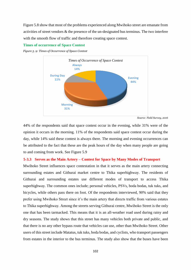
102
Figure 5.8 show that most of the problems experienced along Mwihoko street are emanate from
activities of street vendors & the presence of the un-designated bus terminus. The two interfere
with the smooth flow of traffic and therefore creating space contest.
Times of occurrence of Space Contest
Figure 5. 9: Times of Occurrence of Space Contest
Source: Field Survey, 2016
44% of the respondents said that space contest occur in the evening, while 31% were of the
opinion it occurs in the morning. 11% of the respondents said space contest occur during the
day, while 14% said these contest is always there. The morning and evening occurrences can
be attributed to the fact that these are the peak hours of the day when many people are going
to and coming from work. See Figure 5.9
5-3.3 Serves as the Main Artery – Contest for Space by Many Modes of Transport
Mwihoko Street influences space contestation in that it serves as the main artery connecting
surrounding estates and Githurai market centre to Thika superhighway. The residents of
Githurai and surrounding estates use different modes of transport to access Thika
superhighway. The common ones include; personal vehicles, PSVs, boda bodas, tuk tuks, and
bicycles, while others pass there on foot. Of the respondents interviewed, 90% said that they
prefer using Mwihoko Street since it’s the main artery that directs traffic from various estates
to Thika superhighway. Among the streets serving Githurai centre, Mwihoko Street is the only
one that has been tarmacked. This means that it is an all-weather road used during rainy and
dry seasons. The study shows that this street has many vehicles both private and public, and
that there is no any other bypass route that vehicles can use, other than Mwihoko Street. Other
users of this street include Matatus, tuk tuks, boda bodas, and cyclists, who transport passengers
from estates in the interior to the bus terminus. The study also show that the buses have been
Evening 44%
Morning31%
During Day11%
Always14%
Times of Occurrence of Space Contest
103
attracted to the study area due to the large population residing within Githurai area, and are in
need of transport to Nairobi city where majority eke out a living. Another class of users include;
wheelbarrow pushers and cart pushers who carry goods to and from the market. At the same
time, this street is used by many pedestrians who walk towards the bus stage en-route to and
from places of work. All of them contest for space on the carriageway. The pedestrians have
been forced to walk on the carriageway; which unfortunately is shared by buses, Matatus, tuk
tuks, boda bodas (motor cyclist), cart pushers, and wheelbarrow pushers. This has seen the
upsurge of accidents caused mostly by boda bodas who prefer using the wrong side of the
street, and in so doing, harass pedestrians who in most cases are not aware of the boda boda
following them from behind. The respondents also said that informal traders have taken part
of the street reserve leaving very little space between their business structures and the
carriageway. This has forced the other street vendors to take over sections of the carriageway
and in so doing, slow down every other street user.
5-3.4 Context of Space between Economic & Transportation Land Use
Mwihoko Street attracts a lot of traffic as evidenced from the fact that it is the main artery
serving many users. This traffic is viewed as potential customers by street vendors who then
get attracted towards the street from the back lanes and of particular target, is the large number
of pedestrians who usually walk along Mwihoko Street. When asked on what makes them to
display their wares on the sidewalks of the street, 45% of the street vendors singled out the
large number of pedestrians who commute to and from work. These pedestrians don’t pass
through the back lanes, and so the vendors are forced to be strategically stationed where
potential customers pass. Furthermore, a greater percentage of the vendors view the street as a
no man’s land where they don’t require any permission for use. Because of this perception, a
large number of vendors have occupied some sections of the street where they have put up
temporary structures from where they operate from. Some vendors compete for space with
other street users by occupying the carriageway using wheelbarrows and handcarts on which
they carry their wares (see plate 5.8). This action inhibits the movement of pedestrians and
vehicles within the study area. The buses that usually use the site near the roundabout, are
pushed to the service lane of Thika superhighway, thus end up affecting the traffic flow along
the superhighway. Businesses from adjacent buildings responded that they have to beat
competition from street vendors, by displaying their wares outside their shops in order for
potential customers to see them. Thus they have taken part of the sidewalk where they exhibit
their goods and wares. 90% of boda boda riders regard the site they occupy to be so strategic
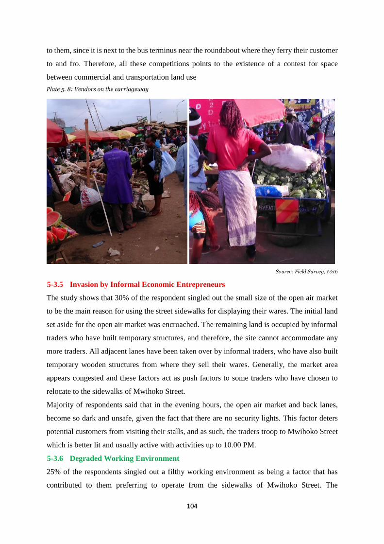
104
to them, since it is next to the bus terminus near the roundabout where they ferry their customer
to and fro. Therefore, all these competitions points to the existence of a contest for space
between commercial and transportation land use
Plate 5. 8: Vendors on the carriageway
Source: Field Survey, 2016
5-3.5 Invasion by Informal Economic Entrepreneurs
The study shows that 30% of the respondent singled out the small size of the open air market
to be the main reason for using the street sidewalks for displaying their wares. The initial land
set aside for the open air market was encroached. The remaining land is occupied by informal
traders who have built temporary structures, and therefore, the site cannot accommodate any
more traders. All adjacent lanes have been taken over by informal traders, who have also built
temporary wooden structures from where they sell their wares. Generally, the market area
appears congested and these factors act as push factors to some traders who have chosen to
relocate to the sidewalks of Mwihoko Street.
Majority of respondents said that in the evening hours, the open air market and back lanes,
become so dark and unsafe, given the fact that there are no security lights. This factor deters
potential customers from visiting their stalls, and as such, the traders troop to Mwihoko Street
which is better lit and usually active with activities up to 10.00 PM.
5-3.6 Degraded Working Environment
25% of the respondents singled out a filthy working environment as being a factor that has
contributed to them preferring to operate from the sidewalks of Mwihoko Street. The
105
respondents complained of the state of the open air market and the adjacent lanes that are in a
pathetic state. They noted that cleaning of the place is rarely done, and when done at all, the
rubbish is hipped together at certain corners of the lanes that take a long time to move to
dumping sites. The problem is more pronounced during rainy seasons when the footpaths
become muddy and therefore making the place unattractive to customers who stay away.
Respondents also pointed out to the littering that takes place, which pile in the drains blocking
it. The blocked tunnels retain storm water which stagnates, releasing foul smell to the
environment. The respondents said that when faced with such challenges of making losses,
most of them migrate to safe grounds which happens to be sidewalks of Mwihoko Street. Thus,
the filthy working environment becomes a push factor that makes traders move from their sites
of operation to areas with customers.
5-3.7 Context of Space between Formal and Informal Traders
Traders from adjacent commercial buildings complained of the stiff competition they faced
from street vendors who occupy spaces in front of their shops blocking access to their premises
and therefore denying them potential customers. The street vendors also block loading vehicles
from accessing business premises, and this usually forces business owners to hire security to
chase away the vendors, who in turn complain that shop premises are not supposed to extend
to the street reserve. Therefore, the study shows that there is space context between formal
traders housed in commercial buildings along the street, and the informal traders who occupy
spaces in front of their shops.
In summary, this section has highlighted some of the factors as noted by respondents that have
contributed to space contestation a long Mwihoko street and are as follows: that there is space
contest between motorized & NMT; that Mwihoko street serves as the main artery and therefore
there is space context by different modes of transport; that there is space context between
economic & transportation land use; invasion by informal economic entrepreneurs has
contributed to space contest along Mwihoko street; and lastly, that degraded working
environment has contributed immensely to space contest in that such conditions do not provide
a good environment for both traders and customers.
5-4 Planning and Development Implications of Street Space Contestation
The research reveals that space use Contestation in the study area has had various planning and
development implications. This section highlights respondents’ views as follows:-

106
5-4.1 Traffic Jams
Many respondents singled out traffic jams as being the most glaring implication of Street Space
Contestation along Mwihoko Street. They stated that contest for space between motorized and
NMT has increased traffic jams as there is no clear segregation of different modes. Therefore,
with the narrowing of the street, most of these modes contest for space on the carriageway and
in so doing, curtail movement. Respondents said that in some days, when there are no police
officers to direct traffic, the jam can go up to Progressive Estate, which is 2 km away from the
study area. 30% of the respondents said that there are very few traffic officers who get assigned
to the study area to direct traffic. Those who come, usually concentrate on the roundabout at
the underpass, and rarely visit the T-junctions along the study area that cause a lot of
interference on the through traffic.
5-4.2 Experiences a lot of Traffic
The study shows that Mwihoko street experiences a lot of traffic, and this the respondents attributed it
to the fact that it is an artery of many estates which connects them to Thika superhighway. All the
traffic is directed to this one street since it is the only one that is tarmacked and all weather. And fact
that it is the only one that joins Githurai 45 to 44 through the underpass, it is therefore preferred by
both motorists and pedestrians who cross over from Githurai 45 to Githurai 44.
5-4.3 Reduced Street Size - unclear demarcation of economic & transportation land
uses
Respondents said that Space use Contestation along Mwihoko Street has led to Reduced Street
Size, and therefore there is unclear demarcation of economic & transportation land uses. Survey
maps show the street to being 25 metres wide, but on the ground, it is less than 25 metres. The
width is not uniform, but varies depending on the kind of encroachment at a given place or site.
This has resulted from the actions of some actors who view street space as a no mans’ land that
any person can access and utilize as they wish. This view is what has continued to pull many
people who are unemployed to join the sector.
Majority of the respondents of street vendors prefer the situation along Mwihoko Street since
they are able to access many customers thus increased sales and profits. But they are faced with
a number of challenges. 65% of street vendors do not belong to any organisation. Those who
do, are structure owners only. Some of the benefits they get from their organisation include;
allocation of sites, and security arrangement for goods in their stalls. On rate payment, the
traders with structures said they pay rates of Kshs. 30 to Kiambu County officers on a daily
basis, but complained that they don’t know what their taxes are used for, since essential services
are missing from the area.
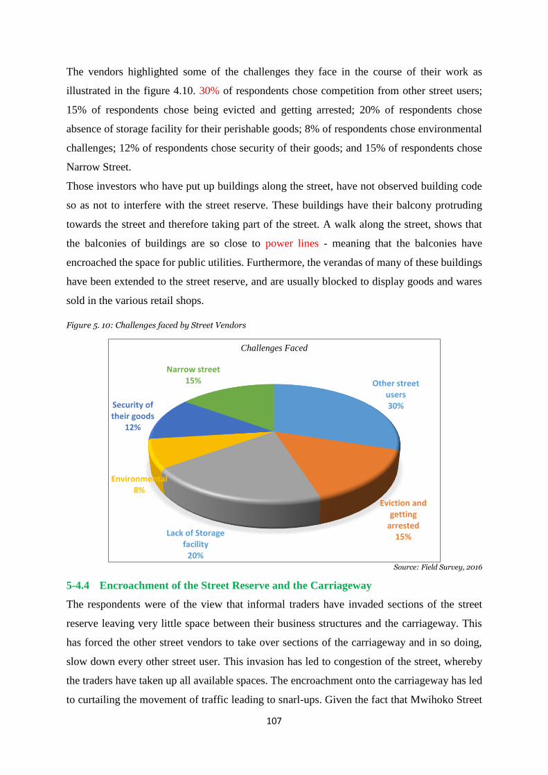
107
The vendors highlighted some of the challenges they face in the course of their work as
illustrated in the figure 4.10. 30% of respondents chose competition from other street users;
15% of respondents chose being evicted and getting arrested; 20% of respondents chose
absence of storage facility for their perishable goods; 8% of respondents chose environmental
challenges; 12% of respondents chose security of their goods; and 15% of respondents chose
Narrow Street.
Those investors who have put up buildings along the street, have not observed building code
so as not to interfere with the street reserve. These buildings have their balcony protruding
towards the street and therefore taking part of the street. A walk along the street, shows that
the balconies of buildings are so close to power lines - meaning that the balconies have
encroached the space for public utilities. Furthermore, the verandas of many of these buildings
have been extended to the street reserve, and are usually blocked to display goods and wares
sold in the various retail shops.
Figure 5. 10: Challenges faced by Street Vendors
Source: Field Survey, 2016
5-4.4 Encroachment of the Street Reserve and the Carriageway
The respondents were of the view that informal traders have invaded sections of the street
reserve leaving very little space between their business structures and the carriageway. This
has forced the other street vendors to take over sections of the carriageway and in so doing,
slow down every other street user. This invasion has led to congestion of the street, whereby
the traders have taken up all available spaces. The encroachment onto the carriageway has led
to curtailing the movement of traffic leading to snarl-ups. Given the fact that Mwihoko Street
Other street users30%
Eviction and getting
arrested15%Lack of Storage
facility 20%
Environmental8%
Security of their goods
12%
Narrow street15%
Challenges Faced

108
is the main artery connecting to Thika superhighway, other street users have no option but to
endure their suffering and stress. 25% of respondents said there has been increased fuel
consumption that has led to high transport cost for vehicles passing through the study area.
16% of the respondents said the space use contest has resulted in delayed trips and low daily
income to Matatus and buses, serving the area.
5-4.5 Blocked Storm Drains
From the field survey, and views of respondents, the study shows that space use contest has
had some other planning and development implications. More specifically, the re-location of
traders from the open Air market, & those from the inner lanes due to degraded working
environment, has pushed many of these traders to sites along Mwihoko street where most of
them have elected structures over storm water drains. Garbage from the informal activities
carried from those structures ends up being thrown into the drains. This has led to blockage of
the drains making them to retain filthy water that endangers the health of the residents as can
be seen on plate 5.9.
Plate 5. 9: Blocked Storm Drains
Source: Field Survey, 2016
According to 40% of the respondents said that clearing of these drains takes a long time, and
blamed the county officials in charge of environment of posting very few cleaning personnel
that get overwhelmed by the enormous garbage produced in the study area. This situation has
forced traders within the affected sites to clear respective sections they occupy, but
unfortunately, they have no enforcement mechanism on those who fail to clean their sections.
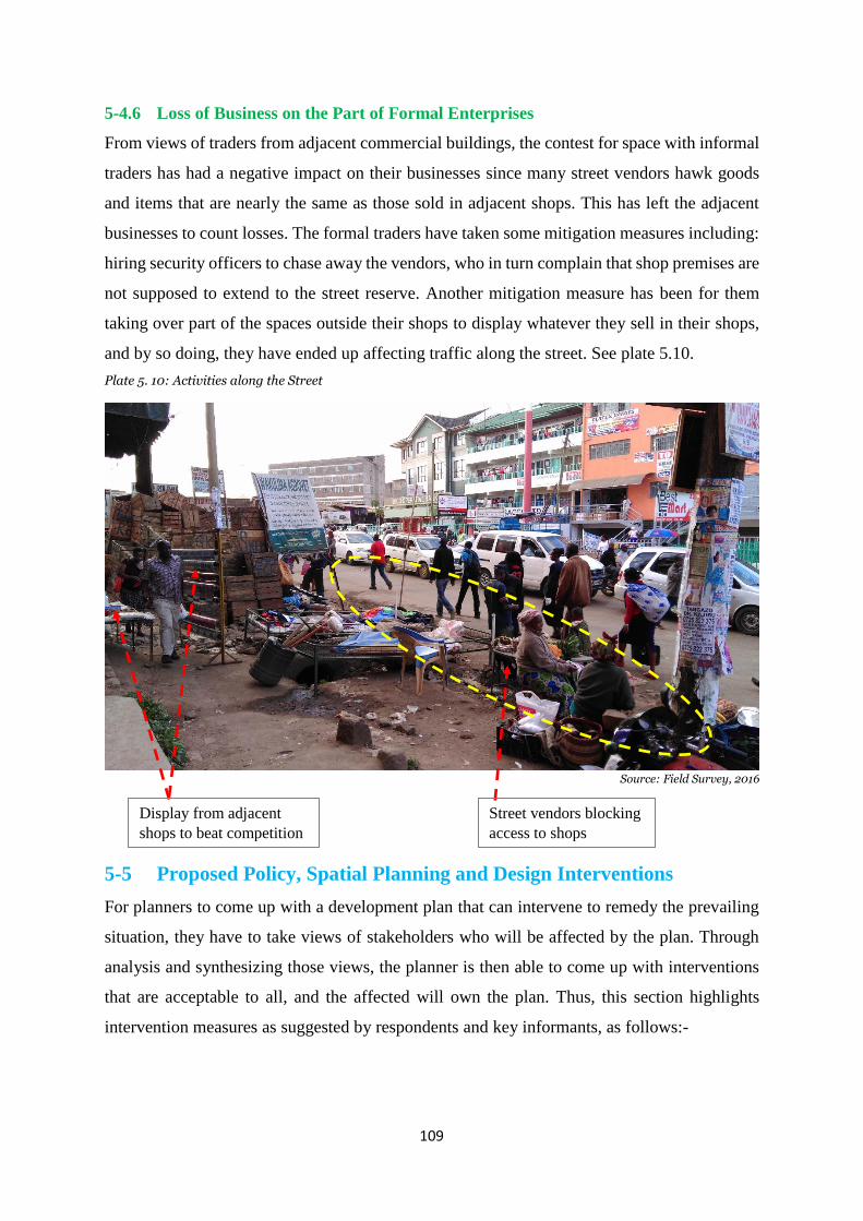
109
5-4.6 Loss of Business on the Part of Formal Enterprises
From views of traders from adjacent commercial buildings, the contest for space with informal
traders has had a negative impact on their businesses since many street vendors hawk goods
and items that are nearly the same as those sold in adjacent shops. This has left the adjacent
businesses to count losses. The formal traders have taken some mitigation measures including:
hiring security officers to chase away the vendors, who in turn complain that shop premises are
not supposed to extend to the street reserve. Another mitigation measure has been for them
taking over part of the spaces outside their shops to display whatever they sell in their shops,
and by so doing, they have ended up affecting traffic along the street. See plate 5.10.
Plate 5. 10: Activities along the Street
Source: Field Survey, 2016
5-5 Proposed Policy, Spatial Planning and Design Interventions
For planners to come up with a development plan that can intervene to remedy the prevailing
situation, they have to take views of stakeholders who will be affected by the plan. Through
analysis and synthesizing those views, the planner is then able to come up with interventions
that are acceptable to all, and the affected will own the plan. Thus, this section highlights
intervention measures as suggested by respondents and key informants, as follows:-
Street vendors blocking
access to shops
Display from adjacent
shops to beat competition
110
5-5.1 Upgrade the Street to Dual Carriage
60% of motorists had the view that the problems experienced along Mwihoko Street are made
worse by: reckless driving of some motorists, tuk tuks, boda bodas; cyclists, and cart pushers
who are fond of overtaking on the wrong side of the road and thereby blocking oncoming traffic
and therefore, worsening the problem. They proposed a barrier to be erected to separate traffic
going on opposed sides so as to avoid the current interference being experienced. They also
suggested that if the upgrading can be done to make the street a dual carriage, that it will be a
much better improvement.
5-5.2 Provision of Non-Motorized Transport (NMT)
Most pedestrians were of the view that problems experienced along Mwihoko street resulted
from; poor street design that does not recognize different users, and also problems of
encroachments from various informal activities. To remedy this, 90% of pedestrians were of
the view that Mwihoko Street should be improved to accommodate segregation of users that
should include provision of NMT.
Majority of pedestrians also complained of non-provision of zebra crossing and road bumps
along the street. This challenge has led most pedestrians and customers to cross from one side
of the street to the other, at undesignated places. Sometimes this has led to accidents more so
caused by motor cyclists who like speeding.
5-5.3 Construction of a Bus Terminus
Githurai market Centre serves as a transit point for many residents from surrounding estates
and towns, who work in Nairobi. They are usually ferried to Githurai by use of Matatus that
terminate journeys in Githurai and then connect their journey to Nairobi by using Githurai
buses. Unfortunately, there is no designated bus terminus, rather they have converted sections
of Mwihoko Street to be the terminus. 85% of respondents were of the view that this
undesignated terminus is the major cause of the traffic snarl-up experienced in the study area.
It attracts all kinds of traffic; from pedestrians, boda bodas, tuk tuks, street vendors, and all
kinds of informalities. They proposed a terminus be constructed on the land along the service
lane of Thika superhighway, which had been set aside for its construction.
5-5.4 Removal of Street Vendors
15% of motorists were of the view that street vendors should be removed from the street to
ease the congestion experienced in the study area. They blamed the vendors for conducting
their trade on the carriageway and in so doing, curtailing movement of other road users. They
blame them also, for taking much of the space set aside for pedestrian passage, and thus,

111
pushing pedestrians onto the carriageway, where they contest for space with vehicle, boda
bodas, tuk tuks, cyclists and cart pushers. 20% of pedestrians were of view that the vendors
should be given alternative sites to conduct their business. 30% of adjacent business owners,
were of the view that the street vendors should be removed from the streets accusing them of
blocking their business premises and bring unfair competition outside formal businesses.
5-5.5 Improve Working Environment
Many street vendors were of the view that poor working environment is a push factor that has
contributed to them relocating from back lanes to Mwihoko Street. They complained of the
poor drainage that leads to muddy lanes which discourages customers from venturing to those
lanes to buy goods. The street vendors were of the opinion that their working environment
should be improved so that potential customers can follow them to the back lanes, which are
filthy and unattractive at the moment. They proposed the back lanes to be paved with provision
of culverts for proper drainage. Plate 5.11 illustrates a well paved back lane.
Plate 5. 11: Image of a well paved back lane used by vendors
Source: Research by SEWA, 2012
5-5.6 Provision of Traffic Police Officers
Majority of respondents were of view that the study area is not provided with Traffic Police
Officers to control traffic when there is a snarl-up. They said that those Traffic Officers who
operate in the area, concentrate on controlling traffic at the roundabout, and rarely venture
towards Mwihoko Street. The respondents were of the view that more officers should be
assigned to the study area to direct traffic given the fact that Mwihoko Street has many T-
junctions, and is a major artery connecting many estates with Thika superhighway.

112
5-5.7 Response from Key Informants
Planner
The Planner in-charge of Ruiru Sub-County, gave the history of the Centre which according to
him came up as a result of a subdivision scheme. Most of the plots here measure 0.02 ha. The
interview showed that there is no local physical development plan (LPDP) that can guide
development in Githurai urban Centre. The structures built here are controlled by council by-
laws which have outlined the building heights that structures should not go beyond due the
fragility of the soils in the area. In absence of a land use plan; a lot of unauthorized land uses,
inadequate infrastructure and uncontrolled land subdivision have taken place in Githurai.
Some buildings have not observed the building line nor done any setbacks, but instead have
encroached on the road reserve. The absence of a development plan has contributed to influx
of informal activities within Githurai which is nearly getting out of hand. The planner singled
out space provision and attitude of road users as being the leading challenges facing Mwihoko
Street. Another setback noted by the planner is that the Centre lies on the boundary of two
counties of Nairobi and that of Kiambu. As such, there has always been a problem as to who
should initiate planning, and how development control should be carried out. The two sides
have tended to concentrate on their side of town in terms of cleaning, but due to the free
movement of people from one side to the other, they always get overwhelmed. The planner
also noted that plans are underway for the preparation of a UIDP for Githurai through funding
from World Bank. This may go a long way to solve many of the problems being experienced
currently, given the fact that the project will involve diverse stakeholders, the two counties
included.
Traffic Department
Interview with head of traffic Kasarani, revealed that they are the ones in-charge of controlling
traffic in Githurai, but they are overstretched since they cover a wide area. Normally, Githurai
is manned by two officers who are supposed to control the large number of vehicles that use
that intersection. The officer noted that the bus terminus has not been built yet, but in the
meantime, the buses are using part of Mwihoko Street as the terminus for picking and dropping
passengers. The traffic officer, also observed that the main causes of space contest and
accidents along this street, is the negative behaviour of street users; and the influx of: street
vendors, boda bodas, tuk tuks and taxi drivers. He went further to note that the licensing and
registering institution for motorcycles is not observing the optimal number that can operate
efficiently without overcrowding the place.

113
Pedestrians suffer the most when it comes to road accidents, for they use the carriageway for
their movement. There are no traffic control signs which makes it difficult for officers to
control traffic. The officer proposed the construction of a bus terminus from where all vehicles
can operate from and therefore easy congestion in the study area.
Matatu Owners Sacco
The Matatu owners Sacco noted that the number of traffic Police operating in the study area
are few, thus unable to control the traffic. They chose influx of boda bodas, tuk tuks, and taxis;
influx of street vendors; space provision for road users and behaviour of road user; to be the
main challenges facing their operation in the study area. They also singled out institutional
regulation as not being pro-active in bringing order within the study area. They requested the
bus terminus to be constructed so that contest for space use in the study area may be reduced.
The general view held by many respondents was that Githurai market Centre is growing at very
high rate and therefore, authorities needs to upgrade it to a full town so that necessary facilities
and services can be availed. The respondents also highlighted challenges facing the area to be:
perennial water scarcity, drainage challenges, traffic jams, challenges of waste disposal, lack
of sewer line, lack of bus terminus, and the filthy environment under which the traders operate
in. They therefore recommended the county government of Kiambu to look into those
grievances so as to make Githurai the future they want. They were also of the view that the
central government should handle street expansion, while the county government handles
service provision through town management committee.

114
CHAPTER 6: MEDIATING STREET SPACE USE CONTESTATION
This chapter highlights proposals that may be pursued so that the current situation can be
contained. From literature review and various case studies, the current situation along
Mwihoko street can be mediated by using different fronts as proposed in this chapter:
6-1 Nil Intervention
Nil intervention is a situation where the status quo along Mwihoko street may be allowed to
continue without any interference. There are many people who will like that to happen so as
they may continue to benefit from the status quo. But if this is allowed to happen, the situation
is likely to deteriorate since the population of Githurai and surrounding estates, is anticipated
to increase, and therefore, informal activities are also likely to increase. Thus, the nil
intervention cannot be proposed as a solution for the current situation.
6-2 Upgrading and Rehabilitation option
Upgrading and Rehabilitation is an approach that may be pursued so as to bring order along
Mwihoko street. Since the degraded working environment and congestion were cited as some
of the reasons making informal traders to relocate from the open air market and back lanes, as
a proposal, the study proposes the modernisation of the market through utilising vertical space
by building a storey structure that will accommodate more traders. Such market will then be
divided into individual stalls that can be allocated to traders. The storey market can take the
form of the New Kongowea market in Mombasa built by the National government in conjunction with
the county government of Mombasa, in response to many years of neglect of the old Kongowea market.
See plates 6.1 and 6.2 for illustration.
The market will be a pull factor, since it will offer many advantages including: security, storage
facility, shelter from environmental challenges, and clean environment. There is also more land
along the railway reserve where another modern storey market can be built. This is currently
used as an open air market. Thus, if the area can have at least two modern storey markets that
can absorb most of the vendors, then the problem of encroachment on Mwihoko Street will be
contained.
Such market improvement project should be carried out as a marshal plan for the area, which
will then include paving most of the back lanes - that at the moment, get muddy when it rains.
The paving should be done with provision of culverts for proper drainage. The improvement
will also include drainage to get rid of stagnant waste water that is a common occurrence in the
study area, plus street lighting that will encourage vending activities to continue beyond 6 pm
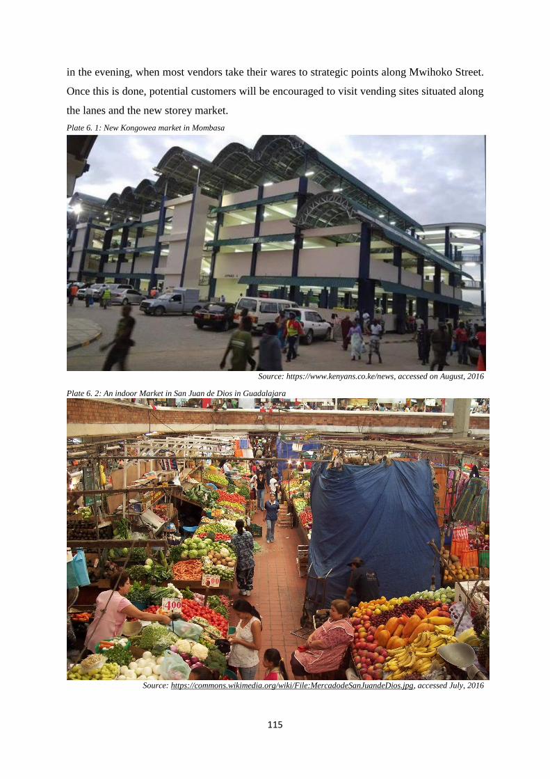
115
in the evening, when most vendors take their wares to strategic points along Mwihoko Street.
Once this is done, potential customers will be encouraged to visit vending sites situated along
the lanes and the new storey market.
Plate 6. 1: New Kongowea market in Mombasa
Source: https://www.kenyans.co.ke/news, accessed on August, 2016
Plate 6. 2: An indoor Market in San Juan de Dios in Guadalajara
Source: https://commons.wikimedia.org/wiki/File:MercadodeSanJuandeDios.jpg, accessed July, 2016
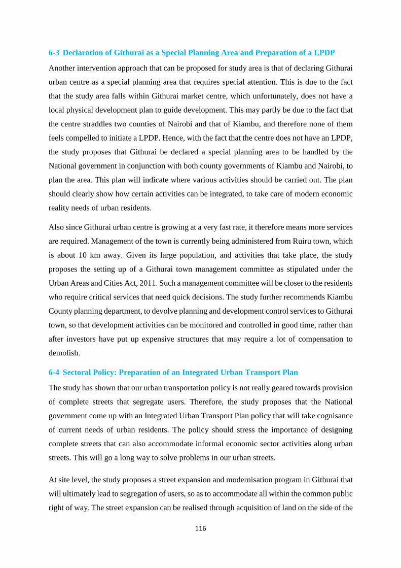
116
6-3 Declaration of Githurai as a Special Planning Area and Preparation of a LPDP
Another intervention approach that can be proposed for study area is that of declaring Githurai
urban centre as a special planning area that requires special attention. This is due to the fact
that the study area falls within Githurai market centre, which unfortunately, does not have a
local physical development plan to guide development. This may partly be due to the fact that
the centre straddles two counties of Nairobi and that of Kiambu, and therefore none of them
feels compelled to initiate a LPDP. Hence, with the fact that the centre does not have an LPDP,
the study proposes that Githurai be declared a special planning area to be handled by the
National government in conjunction with both county governments of Kiambu and Nairobi, to
plan the area. This plan will indicate where various activities should be carried out. The plan
should clearly show how certain activities can be integrated, to take care of modern economic
reality needs of urban residents.
Also since Githurai urban centre is growing at a very fast rate, it therefore means more services
are required. Management of the town is currently being administered from Ruiru town, which
is about 10 km away. Given its large population, and activities that take place, the study
proposes the setting up of a Githurai town management committee as stipulated under the
Urban Areas and Cities Act, 2011. Such a management committee will be closer to the residents
who require critical services that need quick decisions. The study further recommends Kiambu
County planning department, to devolve planning and development control services to Githurai
town, so that development activities can be monitored and controlled in good time, rather than
after investors have put up expensive structures that may require a lot of compensation to
demolish.
6-4 Sectoral Policy: Preparation of an Integrated Urban Transport Plan
The study has shown that our urban transportation policy is not really geared towards provision
of complete streets that segregate users. Therefore, the study proposes that the National
government come up with an Integrated Urban Transport Plan policy that will take cognisance
of current needs of urban residents. The policy should stress the importance of designing
complete streets that can also accommodate informal economic sector activities along urban
streets. This will go a long way to solve problems in our urban streets.
At site level, the study proposes a street expansion and modernisation program in Githurai that
will ultimately lead to segregation of users, so as to accommodate all within the common public
right of way. The street expansion can be realised through acquisition of land on the side of the

117
open air market, which has not developed much. This side of the street will be cheaper to
acquire since compensation may not be as high. As can be seen from figure 6.1, the street can
be segregated into various zones that include: roadway zone, curb side zone, amenity zone,
walking zone and frontage zone.
Figure 6. 1: Design Example of a modern street
Source: Author, 2017
But because of the uniqueness of this street, the curb side zone should be discouraged, and
instead be replaced with a bike lane that will serve both boda bodas and regular cyclists. Such
segregation will bring order to the study area, where all residents and passers-by will be
winners. There should be a permanent barrier separating the cycling path from the roadway
zone, so as to minimise interference of traffic on the roadway. The walkway should also have
barriers that will prevent cyclists from passing there. This will enable pedestrians to have an
un-interrupted walk along the study area. Plate 6.3, is an example of a well segregated street -
running through central London - from Tower Hill to Lancaster Gate.

118
Plate 6. 3: Barriers used to delineate between pedestrian and vehicle zone
Source: Urban Street Design Guide, 2013
The modernised street should have well placed road signage to assist pedestrians when crossing
from one side of the street to the other. These should include; zebra crossing markings, traffic
lights and foot bridges at designated points along the study area. See figure 6.2 and 6.3. Given
the fact that Mwihoko Street is the main artery connecting residents to Thika superhighway,
many prefer using it since it has tarmac, and when it rains, its surface condition is relatively
good. Its good state has become its undoing, whereby it attracts all kinds of traffic.
There is another street (has no name) that was designed to relief pressure off Mwihoko Street,
but has been neglected and thus, is in bad state. Many residents avoid it, preferring to use
Mwihoko Street. Thus, as a proposal, this minor street (has no name) should be improved to
tarmac level so that it acts as a by-pass through which residents can pass through to avoid the
chaos experienced along Mwihoko Street. See map 6.1 for illustrations.
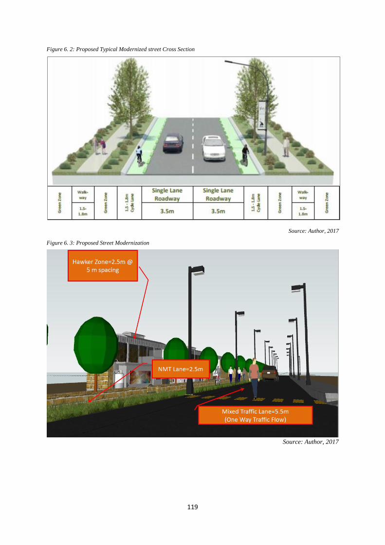
119
Figure 6. 2: Proposed Typical Modernized street Cross Section
Source: Author, 2017
Figure 6. 3: Proposed Street Modernization
Source: Author, 2017

120
Map 6. 1: Proposals to relieve pressure from Mwihoko Street
Source: Author, 2017
Proposals
121
6-5 Sectoral Policy on Street Vending
Another approach the study proposes so as to bring order along Mwihoko street, is that of
pursuing a sectoral policy on street vending. Literature review has shown that the problem of
informal traders invading urban streets, is a common phenomenon in many countries. Some of
these countries have taken initiatives that guide this sector. They have done this through
national policies initiated by those involved in the sector. A classic example, is India where
informal sector activities is thriving. The study therefore proposes an initiative be borrowed by
the Kenyan government, to create a policy that will guide the informal sector activities - more
so, street vending. Such policy should be an initiative of all stakeholders in the sector.
One of the requirement of such a policy, should be that vendors must belong to an association.
The reason for this, is to make it easier to control their activities, and take care of their welfare
in general. Street vendors are currently an unwanted lot in most urban areas, but vending is the
only source of income to many involved in this activity. Thus the policy should come in to
address the new reality, that street vending is here to stay for a long time. The policy should
advocate for designing urban streets that are wide enough to cater for all users. The number of
people involved in informal activities has increased in recent times not only within the study
area, but in many urban centres throughout the country. Even though informal sector has been
in existence since independence, the sector has attracted many people in the recent times. This
sector has proved to be a source of income for many who have not landed an employment
opportunity. Thus, this sector cannot be wished away, but rather be harnessed and assisted to
develop into SMEs.
Many people have argued against the presence of vendors on streets, saying that they are a
menace to the well-functioning of a street. But it has been proved by various researchers that
the presence of street vendors in an area, curtails some insecurity issues - i.e. street traders’
presence on the streets means that there are many extra eyes to discourage other people from
committing crime. This is why criminal activities are high in places that are deserted, and
pedestrians always try to avoid passing through such areas, and those who do, fall victims of
muggings. Thus, the presence of street vendors along Mwihoko Street will enhance security
and therefore, prolong the time of doing business. Hence, the study proposes sites to be set
aside along the improved street, where some vendors will be allowed to display their wares.
See plate 6.4 and 6.5 for illustration.

122
Plate 6. 4: Kind of stalls that can be put up along the street
Source: https://www.google.com/imgres
Majority of the street vendors will be relocated to the improved sites along the railway reserve.
Possible zones to be occupied along the street will be that of amenity since they are usually
placed above certain heights or placed underground – thus, there will be no interference from
the vendors given that no permanent structures will be allowed on these sites. Such sites will
be secured by creating a barrier between the curb side zone and amenity zone. The vendors will
operate in such a way that they face the walking zone and frontage zone. By so doing, the
vendors will not block entrance to businesses operating from buildings along the street – thus
reducing the conflict between business owners and the street vendors since they will be sharing
potential customers who will be passing along the walking zone. See plate 6.5 and 6.6.
Plate 6. 5: Vendor stalls facing adjacent shops
Source: https://www.google.com/imgres

123
Plate 6. 6: Good example of curb side cafés providing access to all
Source: Road Encroachment Policy – Melbourne; accessed July, 2016
6-6 Redevelopment Approach: Integrating Market and a Terminal Facility
Another intervention approach that may be pursued is the redevelopment of the area with the
dual projects of market improvement and that of developing a terminal facility. A modern bus
terminus should be constructed on the land that had been set aside for it but nothing so far has
been done. Such facility should be planned to indicate sites for bus terminus, boda boda shades,
and tuk tuk stage. Such terminus will relocate the current undesignated termini from Mwihoko
street, and thereby easing the through traffic. This land can also accommodate a modern storey
market that can serve informal traders. The construction of storey markets should also be
extended to other sites that include: the open air market site, railway reserve land, and other
undeveloped plots within the market centre. Such an undertaking will take in those traders who
are currently displaying their wares along Mwihoko street.
The redevelopment approach of Githurai should be extended to existing and upcoming
commercial buildings to innovatively provide space for informal sector activities. Nearly all
buildings in the study area serve as commercial cum residential uses. These buildings go up to
4 to 5 floors. Commercial activities are usually carried out at the ground floor more so, in those
rooms fronting the streets. In most cases, only two rooms front the street, and thus, are the only
ones used for commercial activities. The other back rooms are rented out for residential use.
Such is the design of most of the buildings in the study area, that they cannot accommodate
many traders. The structure owners can learn from what is happening in the CBD of Nairobi
where building floors have be partitioned to allow for stalls that can accommodate many
traders. The study proposes this to be possible through the involvement of the county

124
government of Kiambu and Ministry of Lands, who should formulate flexible change of user
laws. Such laws will allow commercial buildings facing the street, to be able to partition ground
floors so as to accommodate vendors. Through provision of basic services like: water, sanitary
services, and garbage collection; such improved stalls will attract vendors, since their new
improved working environment will pull many customers leading to more profits. Further, the
county government should waiver tax to such investors who will redevelop their facilities to
accommodate street vendors. In exchange, the investors will be expected to charge a small levy
on the vendors, so as not to discourage them from taking up the stalls. The Literature review
from Thailand, and Rotterdam Market Hall in Netherlands, shows that Private sector can
contribute to provision of space to small scale traders. Such a private investment, can solve
many problems, like: – parking lots, residential units, clean working environment, and a lively
& vibrant surrounding. Map 6.2 illustrates suitable sites for bus terminus and storey markets.
Another place that may be redeveloped for vendors to operate from, is the roundabout under
the flyover. Currently, street vendors display their wares on the road at this roundabout, and in
so doing end up blocking vehicle movement. The study proposes that space to be redeveloped
with platforms as shown in plate 6.7, so as to reduce traffic conflicts, and provide vendors with
shelter.
Plate 6. 7: Example of how the underpass can be improved
Source: Research by SEWA, 2012
A proposal is given for the railway land reserve to be developed and therefore create good sites
that can accommodate Excess vendors from the streets. Also, the undesignated bus terminus
should be moved from its current site which curtail traffic movement in the study area.

125
Map 6. 2: Suitable sites for Bus terminus and Storey Market
Source: Author, 2017
126
6-7 Collaborative Approach in Review of Street Designs
Another way the problem in the study area can be contained, is by adopting a collaborative
approach in review of street designs. Since streets are supposed to accommodate various users,
the government should pass a policy that makes it mandatory for street designers to incorporate
street users while designing urban streets that will serve all users. This component of user
involvement has been missing in our urban streets designs. As the New Zealand pedestrian
planning guide has shown, this can be achieved by use of “a road user hierarchy” which
outlines the considerations that should be taken into account while planning for various users
as outlined in table 2.1.
Again as noted in the design manual for urban roads & streets (UK), street design should
embrace collaborative approaches whereby the design has to take a multidisciplinary design
processes where the design team has to include a broad range of professionals with varying
levels of technical expertise in streets/road design. The final make-up of a design team will
depend on the resources available and the scale of the project. Design input should ideally be
sought from a range of skill sets to ensure that a holistic design approach is implemented. This
process can only work better when the multi-disciplinary professional teams within planning
authorities work together as a cohesive unit, than the case is now when they are working in
isolation without consultation.
6-8 Integrated Approach
Any of the approaches highlighted above (except nil intervention), can be pursued singly to
bring some level of order along Mwihoko street. But, the best result will be achieved by
integrating all these approaches into one plan that will order activities in Githurai urban centre,
and ultimately, solve the problems being experienced along Mwihoko street. Therefore, the
study proposes an integrated approach that will involve: declaration of Githurai as a special
planning area and therefore necessitate the preparation of a LPDP, push for a sectoral policy
that will lead to the preparation of an integrated urban transport plan that will cover the study
area, push for sectoral policy on street vending that will take care of informal traders in our
urban areas, adopt a collaborative approach in review of street designs within the study area,
adopt a Redevelopment Approach that zone in on constructing a storey Market and a Terminal
Facility and at the same time upgrade back streets & lane and also rehabilitate the drainage
system in the study area.
127
CHAPTER 7: SYNTHESIS, CONCLUSION & RECOMMENDATIONS
7-1 Introduction
This Chapter provides synthesis of the findings, conclusion, and recommendations on possible
intervention measures that can be undertaken to address the planning issues identified along
Mwihoko street. The chapter also provides areas for further research.
7-2 Synthesis of the Findings
This section analyses information from literature review concerning the problems experienced
in the study area, and then judgments are made based on the critical reading from various
sources and information gathered from the field. From the study, the main planning issues
observed include:
7-2.1 Planning for Alternative Streets to Access Thika Superhighway
The literature review has shown that road infrastructure is essential for development of a
country. Thus the construction of Thika Superhighway opened the northern sections of Nairobi
for development and expansion along the Superhighway. The down side of the construction of
Thika Superhighway is that the contractor blocked many of the access roads to the
Superhighway leaving a few exits. This has resulted into the challenges experienced in the
study area and in many other estates along Thika Superhighway, where residents are
constrained to use the few exits provided – which in most cases serve as both exit and entry.
This study provides recommendation on how alternative routes can be created to decongest
Mwihoko Street.
7-2.2 Planning for Open Air Markets & Terminal facilities
Literature review, more specifically the physical planning handbook (2007), argues that all
local centres should have an open air market that can serve a catchment population of 5,000
people, while a designated market centre should serve a catchment population of 15,000 with
a resident population of 2,000. Githurai market centre has surpassed these figures whereby the
resident population is around 60,000, while the catchment population is at around 500,000.
With such population, the site set aside for an open air market has proved to be inadequate.
This means the current population is not well served by the existing open air market. The
manifestation of inadequate open air market is the overcrowding of the existing site and
overflow of traders onto nearby streets and thereby impeding traffic, and also affecting the
environment through production of solid waste that ends up blocking drains. With the fact that
land space does not increase/expand, this study proposes recommendation on how more market
128
space can be availed through the utilization of vertical space as demonstrated by case studies
from Asia and Kongowea in Mombasa, and also rehabilitation of neglected sites that can serve
as vendor sites.
7-2.3 Citizen Participation in the Review of Street Designs, & Proposal for a Pro-Active
Street Vendor Associations
Literature review has shown that in Kenya, street designers have not been involving residents
of affected areas while coming up with street designs. Furthermore there is no known manual
for street design in existence that can guide the design in terms of user design priorities for
space use. In the 2010 constitution, Citizen Participation in project implementation is a key
pillar. Literature review from Britain and New Zealand; has shown that in developed countries,
street designers while coming up with street design proposals, must involve residents who will
be affected by that street. The residents are accorded an opportunity to air their views on how
their interests can be taken care of while designing the street. The literature review has also
shown that the designers of streets are usually guided by user hierarchy table as described in
the pedestrian planning and design Guide (2008), of New Zealand. This study proposes citizen
involvement in street design that will ensure provision of space for different street users and
also the incorporation of street vending sites along urban street.
The study also noted that the street vendor association in the study area is not very active in
agitating for street vendors’ rights to authorities. They are only involved in space allocation
and security of the temporary structures. In the case study from India, it was noted that
government has recognized the critical role and contribution of street vendors to the economy,
and as such, through various advocacy groups, it came up with a national policy on street
vending. The policy proposed structures that were necessary for proper functioning of the
sector. And since implementation of this policy, structures were put in place and this sector has
been working so well in managing the operation of vending activities in many urban centres in
India. Such national policy implementation is what is missing in Kenya, and this study
recommends ways and means by which advocacy and awareness might be used by street
vendors to achieve levels experienced in India.
7-2.4 Designing for Diversity
The design of Mwihoko Street is a big concern in that the design gives preference to vehicles
compared to other users who are left to find their way through the study area, causing many to
contest for space on the carriageway. Literature review from manual for street (UK), notes that

129
a well-designed street should be segregated into different user zones that can guide various
users to navigate through the street easily. The study makes recommendation on the adoption
of designs that takes care of all street users, and therefore, reduce the levels of space use
contestation.
7-3 Conclusion
From the study on contestation of street space use by informal activities along Mwihoko Street,
one can safely note that: the rate of urbanization in Kenya has continued to increase, meaning
that services & employment opportunities in our urban centres can no longer be sufficient for
the big number of people moving to these centres. The study has shown that the white collar
jobs that used to absorb many people have become fewer and can only take in very few of those
joining the employment market. Further, the study has shown that the majority relocating to
urban centres have been forced to join the informal sector as their only avenue of employment.
This tell us then that the informal sector will continue to play a fall-back role for the excess
work force, since it doesn’t require much to join. The study has shown that the streets play an
important role in the operations of urban centres, but such role may be undermined if the street
is not well designed to accommodate the multiple functions it ought to serve. The study has
shown that people have different perception about streets e.g. as a place of commons which
can be accessible to all for any kind of activity. This view is propagated mostly by people
involved in the informal sector activities – majority of whom are street vendors.
The study has also shown that some of the factors contributing to space use contestation in the
study area include; inappropriate street design, poor street network within the area, traffic being
directed to one street, reduced size of the open air market, filthy working environment in the
back lanes and in the open air market, thus discouraging customers from visiting those sites.
The study further shows that the most glaring implication of street space use contestation is the
struggle for control of space leading to disorder along the affected street, therefore resulting to
impediment of street users - thus affecting the street from discharging its functions.
Other planning and development implications of street space use contestation include; Non-
compliance of building code resulting from structures being placed on the street reserve, the
size of the street getting reduced from its initial width, street users contesting for the carriage
way since the sidewalks have been taken over, traffic jams being a common occurrence, water
drains have been blocked by litter produced by activities being undertaken, existence of on-

130
street parking, and loss of business by formal enterprises resulting from unfair competition
from those not paying rates and licence fees.
7-4 Recommendations
Recommendations are designed to address and give solutions to the planning issues identified
by the study. The recommendations outlined below are based on: options for policy, legal &
institutional approaches; and site level options.
At policy, legal & institutional level, the study recommends the following:
That the national government creates a policy that will guide the informal sector activities.
Such policy should be an initiative of all stakeholders in the sector.
That Kiambu county government in conjunction with the county government of Nairobi,
embark on coming up with an urban development plan for the centre
That the county government of Kiambu and Ministry of Lands work together and formulate
flexible change of user laws that will allow owners of commercial buildings facing the
street, to be able to partition ground floors so as to provide space that can accommodate
vendors.
That county government of Kiambu should set up of a Githurai town management
committee as stipulated under the Urban Areas and Cities Act, 2011. Such a management
committee will be closer to the residents who require critical services that needs quick
decisions.
That Kiambu County planning department, should devolve planning and development
control services to Githurai town, so that development activities can be monitored and
controlled in good time.
At site level the study recommends the following:
That there should be a modernisation of the market through utilising the vertical space by
building a storey structure that will accommodate more traders.
The county government together with the national government should embark with a street
expansion and modernisation program that will ultimately lead to a complete street which
will segregate users, so as to accommodate all within the common public right of way.
That sites should be set aside along the improved street, where some vendors will be
allowed to display their wares
131
That the national government should support the construction of Wide Non-motorized
Flyovers, on either side of the underpass that will serve pedestrians and street vendors.
That the spaces at the roundabout should be improved with platforms to provide vending
sites for those operating at the roundabout so as to reduce traffic conflicts, and give vendors
shelter.
7-5 Areas for Further Research
Further research can start from where this study ends, to critically analyse the
recommendations proposed and assess the cost implications of the various projects
proposed and potential sources of financing available to both County and National
governments.
Further research can be done to assess the viability of street vendors benefiting from
government sponsored funds: Uwezo fund, and youth & women enterprise fund; given the
fact that they don’t have a permanent site to operate from.
132
BIBLIOGRAPHY AlSayyad, N., Bayn al-Qasrayn (1994). The street between the two palaces. In D. Favro, Z. Çelik, and
R. Ingersoll, editors, Streets: Critical Perspectives on Public Space. Berkeley, CA: University of
California Press, 71–82.
Andersen, G.F. (2015). Sources of Workers Power - A case study of Kenya National Alliance of Street
Vendors and Informal Traders (KENASVIT) in Nairobi
Ayani el al, (2012). Formalising the Informal Streets: A Legislative Review of the Street Vendors
(Protection of Livelihood and Regulation of Street Vending) Bill, 2012 – India.
Banerjee, Tridib (2001). The future of Public Space: Beyond Public Streets and Reinvented
Places. APA Journal Vol. 67 (1): 9-24.
Baxter el al, (2002). Paving the Way - how we achieve clean, safe and attractive streets; - a research
project commissioned by CABE and ODPM.
Beyard el al (2003). Ten Principles for Rebuilding Neighbourhood Retail. Washington, D.C.: ULI–the
Urban Land Institute, 2003.
Bhowmik, S.K. (ed.) (2009). Street Vendors in the Global Urban Economy. Routledge India.
Bhowmik, Sharit K. & Debdula Saha, (2014). Report on Street Vending in Ten Cities in India; National
Association of Street Vendors of India (NASVI)
Blomley, N. K. (2004). Unsettling the city: Urban Land and the Politics of Property. Routledge,
New York, 2003
Bromley, R. (1998). Informal Commerce: Expansion and Exclusion in the Historic Centre of the Latin
American City, International Journal of Urban and Regional Research 22: 2119-2131.
Bromley, R. (2000). Street Vending and Public Policy: A Global Review - an Article in International
Journal of Sociology and Social Policy; Vol. 20 Iss: 1/2, pp.1 – 28, University at Albany - The State
University of New York
Brown, A. (2008). Contested Space: Street Trading, Public Space and Livelihood in Developing Cities,
Warwickshire: Intermediate Technology Publication Ltd.
Brown, A. el al (2014). Inclusive Design for Street Vendors in India - Centre for Urban Equity & Cardiff
University (2014).
CABE, (2002). Paving the Way: How we achieve Clean, Safe and Attractive Streets. London: Thomas
Telford Ltd.
Calnek, E. E., 2003, Tenochtitlan-Tlatelolco: The natural history of a city. In W. T. Sanders, A. G.
Mastache, and R. H. Cobean, editors, El Urbanismo en Mesoamérica/Urbanism in Mesoamerica.
Mexico City, Mexico: Instituto Nacional de Antropología e Historia and the Pennsylvania State
University Press, 149–201.
Chen, M. (2006). Rethinking the Informal Economy: Linkages with the Formal Economy and the
Formal Regulatory Environment. Oxford: Oxford University Press.
Chen, M. (2012). The Informal Economy: Definitions, Theories and Policies - WIEGO, Publication
date: August 2012 ISBN number: ISBN 978-92-95095-41-0
Columbia University planning team, (2006). Nairobi Metropolitan Expansion in a Peri-Urban Area
report - May 10, 2006
133
Crawford, M. (1995). Contesting the Public Realm: Struggles over Public Space in Los Angeles.
Journal of Architectural Education, Vol. 49, No. 1. (Sep.,), pp. 4-9.
Davy, B. (2009). The poor and the land - Poverty, property, and planning. Liverpool University Press,
published in Town Planning Review 80 (3) 227–265
de Certeau, Michel. (1984). The practice of Everyday Life. Los Angeles: University of California Press
De Soto, H. (2002). The Other Path: The Economic Answer to Terrorism. Publisher, Basic
Books, 2002 – reprint
Department for Environment, Transport and the Regions (DETR), (1998). Places, Streets and
Movement: A Companion Guide to Design Bulletin 32 – Residential Roads and Footpaths. London:
TSO.
Donovan, M. G. (2008). Informal Cities and the Contestation of Public Space: The Case of Bogotá's
Street Vendors, 1988 –2003, Urban Studies 45(1): 29-51.
Esim, S. (1996), 'Guinea Bissau' in Webster, L. and Fidler, P. (eds.), - The Informal Sector and
Microfinance Institutions in West Africa, Washington DC: The World Bank. 139-152.
Fapohunda, OJ. (1985). The Informal Sector Of Lagos: An Inquiry Into Urban Employment. Lagos:
University Press Ltd.
Fidler, P. and L. Webster (1996), 'The informal sector of West Africa' , in Webster, L. and Fidler, P.
(eds.), The Informal Sector and Microfinance Institutions in West Africa, Washington DC: The
International Bank for Reconstruction and Development. The World Bank. 5-20.
Franck, K. A., & Stevens, Q. (2007). Loose space: Possibility and diversity in urban life.
London: Routledge.
Glenn D. I. (1992). Fact Sheet PEOD-6, a series of the Program Evaluation and Organizational
Development, Florida Cooperative Extension Service, Institute of Food and Agricultural Sciences,
University of Florida. Publication date: November 1992.
Government of Kenya, (1999). Environmental Management and Coordination Act. Nairobi:
Government printers
Government of Kenya, (2009). Integrated National Transport Policy: Moving a Working Nation.
Nairobi: Government printers
Government of Kenya, (2010). The Constitution of Kenya. Nairobi: Government printers
Government of Kenya, (2012). County Government Act. Nairobi: Government printers
Government of Kenya, (2012). Draft National Urban Development Policy. Nairobi: Government
printers
Government of Kenya, Department of Physical Planning (2008). Physical Planning Handbook. Nairobi:
Government printers
Government of Kenya, Department of Urban Development (2011). National Urban Development
Policy. Nairobi: Government printers
Government of Kenya, Ministry of Planning and National Development (2007). Kenya Vision 2030
Policy. Nairobi: Government printers
Government of Kenya, National Council for Law Reporting, (2011). Urban Areas and Cities Act 2011.
Nairobi: Government printers

134
Government of Kenya, National planning and building authority (2009). Planning and building
regulations – 2009. Government printers, Nairobi. Retrieved on 4/8/2016
https://ia801604.us.archive.org/13/items/ke.building.2009/ke.building.2009.pdf
Government of Kenya, Survey of Kenya (2009). The Survey Act (Revised 2009). Nairobi: Government
printers
Hart, K. (1973). Informal Income Opportunities and Urban Employment in Ghana. The Journal of
Modern African Studies, 11(1), 61-89. Retrieved from http://www.jstor.org/stable/159873
Harvey, D. (2003). The right to the city. International Journal of Urban and Regional Research 27:939-
941
Harvey, D. (2006). Spaces of Global Capitalism. Publisher, Verso, 2006
Healey, P. (1993). The Communicative work of development plans. Environment and Planning. Vol.
20. London: Pion Ltd.
Healey, Patsy, 1993. The Communicative work of development plans. Environment and
Planning. Vol. 20. London: Pion Ltd.
Hope, K.R. Sr. (1997) African Political Economy: Contemporary Issues In Development Armonk, New
York: Sharpe.
Hope, K.R. Sr. (2001), 'Indigenous Small Enterprises Development in Africa: Growth and Impact of
the Subterranean Economy'. The European Journal of Development Research. 13 (1) 30-46.
https://maplesotho.wordpress.com/author/tshedy/page/2/ - Accessed on 10 August, 2016
Jimu, I. M. (2004). An exploration of street vending's contribution towards Botswana's vision of
prosperity for all by 2016 - Department of Geography, Mzuzu University, Malawi
Kalinski, J. (2006). Democracy Takes Command: The new Community Planning and the Challenge to
Urban Design. Urban Planning Today. Minneapolis MN: University of Minnesota Press
Karen A. F. & Stevens, Q. (2007). Loose Space: Possibility and Diversity in Urban Life. New York,
NY: Routledge.
Kenya National Bureau of Statistics & Society for International Development (SID), (2013). Exploring
Kenya’s inequality – pulling apart or pooling together? – Kiambu County
Kenya National Bureau of Statistics, (2010). The 2009 Kenya Population and Housing Census. Nairobi:
KNBS.
Kim, A. (2015). Making way: mapping the street vendors on the sidewalks of Ho Chi Minh City,
Vietnam - http://bedrosian.usc.edu/programs/contesting-the-streets-ii/. Accessed on 20 April, 2016
https://www.google.com/search?q=Rotterdam+Market+Hall,+McManus&tbm=isch&imgil=33-
jNBKvdNobPM%253A%253B9YN-ZhH
Kusakabe, Kyoko. 2006. Policy Issues on Street Vending: An Overview of Studies in Thailand,
Cambodia and Mongolia. Geneva: International Labour Office.
http://www.ilo.org/wcmsp5/groups/public/---asia/---ro-bangkok/documents/publication/wcms_
bk_pb_119_en.pdf (accessed 16 Oct. 2016).
Larbi, T. (2008). Introduction to The World as a Global Agora: Critical Perspectives on Public space
(UK: Cambridge Scholars Publishing, 2008).
Lefebvre, H. (1991). The Production of Space. (Translated by Donald Nicholson-Smith). Blackwell
Publishing
135
Loukaitou el al, (2005). Sidewalk Democracy: Municipalities and the Regulation of Public Space. New
York: Routledge.
Low, S. M. & Smith, N. (2006). The Politics of Public Space - City Planning & Urban Development.
Publisher, Routledge, 2006
Lund, F. & Skinner, C. (2004). Integrating the informal economy in urban planning and governance: A
case study of the process of policy development in Durban, South Africa, International Development
Planning Review, 26(4).
Lyons, M. & Brown, A. (2007). Seen but not heard: Extending urban citizenship to informal street
traders. Paper presented to the Nordic Africa Institute Conference on Informalising Economies and New
Organising Strategies in Africa, Uppsala, Sweden, 20-22.
Mattila, H. (2002). Aesthetic justice and urban planning: Who ought to have the right to design cities?
GeoJournal. Vol 58. pp. 131-138.
Mitchell, D. (1995). The End of Public Space? People’s Park, Definitions of the Public, and Democracy.
Annals of the Association of American Geographers, Vol. 85, No. 1. (Mar. 1995), pp. 108-133.
Mitchell, D. (2003). The right to the city. Social Justice and the Fight for Public Space. New York &
London: Guildford Press
Mitullah, W.V. (2003). Street Vending in Africa Cities: Synthesis of Empirical Findings from Kenya,
Cote d’ Ivoire, Ghana, Zimbabwe, Uganda and South Africa. Washington DC: World Bank.
Mugenda, O. M. and Mugenda. A.G. (1999). Research Methods: Quantitative and Qualitative
approaches.
Muiruri, P. (2010). Women street vendors in Nairobi, Kenya: A situational and policy analysis within
a human rights framework. Addis Ababa, Ethiopia: Organisation for Social Science Research in Eastern
and Southern Africa.
Mwathunga, E. (2014). Contesting space in urban Malawi: A Lefebvrian analysis – unpublished thesis.
Nattrass, N. (1987) 'Street Trading in Transkei- A Struggle Against Poverty, Persecution and
Prosecution', in World Development, 15 (7) 861-875.
Nicholson, S. D. (1991). The Production of Space, Oxford: Basil Blackwell. Originally published
1974. ISBN 0-631-14048-4
Nnkya, T. (2006). An enabling framework; Governance and street trading in Dar es Salaam, Tanzania,
in Brown, A. (ed.), Contested Space: Street trading, public space and livelihoods in developing cities.
Warwickshire, Intermediate Technology Publishing
Olivier, B. (2012). How humans ‘produce’ space: ‘Sustainable’ architecture and the ‘law’ of the
fourfold. South African Journal of Art History, Vol. 26 (1), 2011, pp. 74-84.
Olomola, A. S. (2003). Understanding poverty in Nigeria: highlights from NISER review of Nigerian
development in NISEREEL, the Magazine of the Nigerian Institute of Social and Economic Research,
4 & 5, Ibadan.
Panwar M. and Garg V (2015). Issues and Challenges Faced by Vendors on Urban Streets: A Case of
Sonipat City, India; - www.ijetmas.com February 2015, Volume 3 Issue 2, ISSN 2349-4476, Retrieved
on: 07 November 2016
Post, J. (1996) Space for Small Enterprises: Reflections on urban livelihood and planning in the Sudan,
Amsterdam: Thesis Publishers.
Pratt, M.L. (1999). Arts of the Contact Zone; - keynote address to the Modern Language Association
(1999).

136
Project for Public Spaces (2007).What is Placemaking. Available at;
http://www.pps.org/info/bulletin/what_is_placemaking. Accessed on October 12, 2016.
Rodrigue, (2016). The Geography of Transport Systems (1998-2016), Dept. of Global Studies &
Geography, Hofstra University, New York, USA.
https://people.hofstra.edu/geotrans/eng/ch6en/conc6en/landrent.html
Rodrigue, J. & Notteboom, T. (2016). Transportation and Economic Development. Routledge,
London U.S.A
Rodrigue, J. (2010). The Geography of Transport Systems, Routledge, London U.S.A
Roever, S. (2014); Informal Economy Monitoring Study Sector Report: Street Vendors. Cambridge,
MA, USA: WIEGO.
Rogerson, C.M. and Hart, D.M. (1989), 'The Struggle For The Streets: Deregulation And Hawking in
South Africa's Major Urban Areas', in Social Dynamics, A Journal of Centre for African Studies. 15 (1)
29-45.
Ronald Hope Sr, K. (2014). Informal economic activity in Kenya: benefits and drawbacks. African
Geographical Review, 33(1), 67-80.
Schneekloth, L.H. & Shibley, R. G. (2000). Placing Architecture into the Practice of Place making.
October. Journal of Architectural Education
Sinclair, S. W. (1978). Urbanisation and Labour Markets in Developing Countries. London: Croom
Helm.
Skinner, C. (2008a). The struggle for the streets: processes of exclusion and inclusion of street traders
in Durban, South Africa. Development Southern Africa 25(2).
Stanley et al. (2012), Urban Open Spaces in Historical Perspective: A Transdisciplinary Typology and
Analysis. http://www.public.asu.edu/~mesmith9/1-CompleteSet/StanleyEtAl-OpenSpaces.pdf;
accessed on 28/11/16.
Stout, M. (2008). Place | Participation + Contested Space Local Practices of Place making in Over-The-
Rhine – unpublished thesis.
Swales, J. M. (1990). Genre Analysis: English in academic and research settings. Cambridge:
Cambridge University Press.
UN-Habitat (2009). Planning sustainable cities: Global Report on Human Settlements. London: Earth
Scan Publications Ltd.
UN-Habitat, (2012). Streets as Tools for Urban Transformation in Slums: A Street-Led Approach to
Citywide Slum Upgrading, A UN-Habitat Working Paper first published in Nairobi in 2012.
United Nations (1996), Informal Sector Development in Africa, New York: United Nations.
Webster, F. (2002). Theories of the Information Society. Publisher, Routledge, 2002 Vol. 20.
Webster, L., & Fidler, P. (1996). The informal sector and microfinance institutions in West Africa.
Washington, D.C: World Bank. Chicago (Author-Date, 15th Ed.)
Women in Informal Employment: Globalizing and Organizing (WIEGO) (2012), Street Vendors.
http://wiego.org/informal-economy/occupational-groups/street-vendors
Young et al. (2007). Manual for Streets – UK, Department for Transport: Thomas Telford Publishing,
Thomas Telford Ltd, 1 Heron Quay, London E14 4JD. www.thomastelford.com

137
APPENDICES Appendix 1: Site Observation Checklist
UNIVERSITY OF NAIROBI DEPARTMENT OF URBAN AND REGIONAL PLANNING
M.A. Planning (Urban and Regional Planning) Project
Implications of Urban Street Space Use Contestation by Informal Activities: A Case of Mwihoko Street, Githurai,
Kiambu County
1. How have the buildings been designed?
2. Have the building lines been observed as per the building code?
3. Does the street contain street zones?
4. What is the road width?
5. Are there pedestrian walk ways?
6. Are there cyclist paths along this road?
7. What land uses are adjacent to Mwihoko street? List;
………………………………………………………………………………………………
………………………………………………………………………………………………
………………………………………………………………………………………………
………………………………………………………………………………………………
………………………………………………………………………………………………
………………………………………………………………………………………………
………………………………………………………………………………………………
………………………………………………………………………………………………
………………………………………………………………………………………………
8. What is the nature of encroachment?
9. Are the following activities planned for: parking, garages, carpentry works, timber yards
and eateries along this road?
10. Are there terminal facilities for motorcyclists, tuk tuk, Matatus, and buses?
11. (a) Which road signs exist along the street?
(b) Are they encouraging or discouraging encroachment?
12. (a) Are there road bumps?
(b) And if so, what have been their effect?
13. (a) Are there pavements markings?
(b) If so, are they being followed?
14. What kind of building structures exist on the adjacent land?
………………………………………………………………………………………………
………………………………………………………………………………………………
………………………………………………………………………………………………
………………………………………………………………………………………………
………………………………………………………………………………………………
…………………………………………………………………………………………
15. How are the adjacent formal enterprises? Have they observed the building code or have
they encroached on the road reserve by displaying their wares on pavements?
16. What other informalities exist along this road?
17. Are activities sited in structures or in an open place?
18. What structures exist?
19. Are the activities encroaching on the road?
20. Are there street vendors operating along this road?

138
Appendix 3: Pedestrians Questionnaire
UNIVERSITY OF NAIROBI DEPARTMENT OF URBAN AND REGIONAL PLANNING
Implications of Urban Street Space Use Contestation by Informal Activities: A Case of Mwihoko Street,
Githurai, Kiambu County
Declaration: The information provided in this questionnaire shall be strictly confidential and it is meant
for academic purpose only
Questionnaire No. ……
1. Name of the interviewee (Optional)
……………………………………………………………………
2. What is your marital status? a) married b) single c) divorced d) widowed
3. What is your occupation
a) Student b) Employed i) Formal (Specify) ____________________
ii) Informal__________________ c) Unemployed d) Retired e) Other (specify)
4. Where do stay, and how far is it from here? ---------------------------------------------------
5. What is the purpose of your trip? a) work b) education c) leisure d) buy goods
6. How often do you use Mwihoko Street? Daily Weekly Monthly
7. What problems do you encounter while walking along Mwihoko road?
8. In your own opinion what are the main reasons for this? (rank them from the worst to
the least 1, 2, 3, …n)
Agent Level
Other Pedestrians
Street Vendors
Cyclists
Handcarts
Wheel barrows
Motor cyclists
Buses
Matatus
Lorries
9. At what time are these problems mostly experienced; a) morning, b) day time, c)
evening
10. What can be done to solve or minimize these problems?
11. How do you feel about street traders?
a) I don't like street vendors
b) I like street vendors
c) I think street vendors are good for the economy
d) I don't mind street vendors

139
12. How do you feel about the image that street vendors portray?
a) They portray a negative image
b) They portray a positive image
c) They portray a dirty image
13. Do you purchase items from street vendors?
a) Yes
b) No
14. How often do you purchase items from street vendors?
a) Once a month
b) Once a week
c) More than once a week
d) Never

140
Appendix 4: Motorist Road Users (Vehicle, Motor Bikes, Passengers)
UNIVERSITY OF NAIROBI DEPARTMENT OF URBAN AND REGIONAL PLANNING
Implications of Urban Street Space Use Contestation by Informal Activities: A Case of Mwihoko Street, Githurai,
Kiambu County
Declaration: The information provided in this questionnaire shall be strictly confidential and it is meant
for academic purpose only
Questionnaire No. ……
Name of Respondent (Optional)………………………………………………………………
Name of Interviewer………………………… Place of interview…………………………..
Time of interview……………………………. Date…………………………………………
1. Category of the interviewer (a) Driver (b) passenger
2. Type of motorized Transport (a) Motorcycle (b) Vehicle
3. Nature of Transport (a) Public (b) Private
4. What is the distance of your residence to the study area?
5. Where are you coming from and what is your destination?
6. How frequent do you use Mwihoko road? (Daily, weekly, monthly)
7. How long does it take you to pass the stretch?
8. How many trips do you make in a normal day?
Daily weekly monthly
9. What problems do you encounter along Mwihoko Street?
10. How do you overcome them if they occur during your movement?
11. Who helps to control the traffic along this road?
12. Are they efficient in the controlling the traffic?
13. What do you propose as a solutions to the currents traffic challenges?
THE END (Thank you for your cooperation)

141
Appendix 5: Motor Cyclist, Cart Pushers, and Cyclists - Questionnaire
UNIVERSITY OF NAIROBI DEPARTMENT OF URBAN AND REGIONAL PLANNING
Implications of Urban Street Space Use Contestation by Informal Activities: A Case of Mwihoko Street, Githurai,
Kiambu County
Declaration: The information provided in this questionnaire shall be strictly confidential and it is meant
for academic purpose only
Questionnaire No. ……
1. Name of the respondent……………………………………… Age…………………..
2. Sex………a) male b) female
3. What is your marital status? a) single b) married c) widow/widower d)
divorced/separated
4. Education Level a) None b) primary c) secondary d) tertiary e) university.
5. a) Residence………………………………b) Distance from the study area
6. What is your Household size?
7. Do you carry passengers or goods?
8. a) Do you like this mode of transport?
b) Why?
……………………………………………………………………………………………
……………………………………………………………………………………………
9. Where do you come from, the origin of your trip?
……………………………………………………………………………………………
10. Where are you heading to, the destination of your trip?
………………………………………………………………………………………………
11. What is the distance between origin and destination?
………………………………………………………………………………………………
12. Are there spatial provisions for the use of this mode of transport? Yes or No
13. If they are there, are they adequate? Yes or No.
14. If no, then how do you move along this Mwihoko road?
………………………………………………………………………………………………
……………………………………………………………………………………………
15. What problems/ road conflicts do you encounter using this Mwihoko road?
…………………………………………………………………………………………………
………………………………………………………………………………………
16. How do you overcome them if they occur during your movement?
17. What are the main agents of these problems, ranking them from the most contributing
agent?
18. How do you benefit from using this mode of transport?
…………………………………………………………………………………………………
19. Given the chance which are the possible measures to be put in place to address these
problems?
…………………………………………………………………………………………………
THE END (Thank you for your cooperation)
142
Appendix 6: Street Vendors Questionnaire
UNIVERSITY OF NAIROBI DEPARTMENT OF URBAN AND REGIONAL PLANNING
M.A. Planning (Urban and Regional Planning) Project
Implications of Urban Street Space Use Contestation by Informal Activities: A Case of Mwihoko Street, Githurai,
Kiambu County
Declaration: The information provided in this questionnaire shall be strictly confidential and it is meant
for academic purpose only
Questionnaire No. ……
Respondent Details
1. Name of the respondent………………………………………
2. Gender of the respondent
(i) Male (ii) Female
3. Age of the respondent (tick)
(i) 0 - 17 years (ii) 18 – 25 years (iii) 26 - 35 years (iv) 36 – 45 years
(v) 46 – 55 years (vi) 56 – 65 years (vii) Above 65 years
4. Marital status? a) single b) married c) widow/widower d) divorced/separated
5. Education Level? a) None b) primary c) secondary d) tertiary e) university.
6. Location of residence………………………. Distance from study area……………
Nature of the Business
7. Is your business registered? (a) Yes (b) No.
8. What type of business is being undertaken?
9. Observation of the business location (a) On road reserve, (b) On adjacent parcel (c) in
open air market
10. If not (c), why are you not operating from the open air market?
11. What made you choose this location for your business?
12. Is this your permanent site or you sometimes move to other sites?
13. Why did you locate your business in Githurai and not elsewhere in the neighbouring
estates?
14. What type of goods do you sale?
……………………………………………………………………………………………
……………………………………………………………………………………………
…………
15. Where do you get your supplies from?
……………………………………………………………………………………………
……………………………………………………………………………………………
……………………………………………………………………………………………
16. Who are your target customers?
17. How did you finance the startup of your business? (a) own saving (b) borrow from friends
(c) lending institutions (d) Chama (e) Sacco (f) Other …………………………………
18. Are street vendors organized into groups that work for the general good of all vendors?
(a) Yes (b) No {if No, Go to Q24}
19. If yes, do you belong to any of such groups or organization? (Yes) (No)
20. What are the requirements for one to become a member?
21. What are some of the benefits one may expect by becoming a member?
22. Do you hold meetings to discuss vendors’ welfare? (Yes) (No)
23. If yes, how often? …………………………………………………………….

143
24. Which local authority covers this area? ...................................................
25. What services do they provide?
26. How often do they visit Githurai for the said services?
27. Do you pay tax or rates to the local authority? (a) Yes (b) No
28. If yes, how much do you pay on daily or monthly basis? ......................................................
29. Do you think the money you pay is affordable or expensive to you, in relation to the kind
of business you are undertaking?
Challenges
30. Are there challenges that you encounter in the course of carrying out your business? (a)
Yes (No)
If yes, explain;
……………………………………………………………………………………………
……………………………………………………………………………………………
……………………………………………………………………………………………
……………………………………………………………………………………………
……………………
31. What are these challenges?
Challenges Rank
i. Narrow streets
ii. Accidents from vehicles, motor cycles
iii. Space competition with other road users – pedestrians, matatus, cyclists
iv. Complaints from formal businesses
v. Threats of eviction
vi. Being arrested
vii. Absence of storage facilities for goods
viii. Security of goods
ix. Environmental hazards (specify) – dusty, muddy, flooding, waste disposal,
blocked drainage lines,
x. Nuisance from adjacent land users (specify)
xi. Others (specify)
Rank the above challenges in order of severity.
32. How do you overcome these challenges?
33. Do you have a conflict resolution mechanism with your colleagues?
34. What possible solutions can you suggest to solve these challenges?
……………………………………………………………………………………………
……………………………………………………………………………………………
35. What should the county and national government do, to make your business formal and
free of the above mentioned challenges?
36. Any other concern/ issue/ recommendation
……………………………………………………………………………………………
……………………………………………………………………………………………
THE END (Thank you for your cooperation)
144
Appendix 7: Key Informant Interview Schedule
UNIVERSITY OF NAIROBI DEPARTMENT OF URBAN AND REGIONAL PLANNING
Implications of Urban Street Space Use Contestation by Informal Activities: A Case of Mwihoko Street, Githurai,
Kiambu County
Declaration: The information provided in this questionnaire shall be strictly confidential and it is meant
for academic purpose only
Questionnaire No. ……
(a) Ruiru sub-County Planning Department
Officers’ Name …………………………………………………………………………
Designation ……………………………………………………………………………
1. Is there a land use development plan covering Mwihoko road? a) Yes b) No
2. If yes, what are the proposed standards to be followed by developers?
3. If no, are there other by-laws guiding development?
4. Are they being observed?
5. What are some of the planning challenges facing traffic on this road? (Rank them
according to their levels 1, 2……..n)
Challenge Rank
Space provision for road users
Behaviours / altitude of the road user
Influx of street vendors into the road
Influx of Boda bodas, tuk tuks and tax drivers
Delayed journey
Institutional regulations.
Insecurity
Conditions of the road
Conditions of the vehicles.
Speed of the motorists
Road encroachments
6. What will you propose as an intervention, for the current state of affair to be brought to
manageable levels?
………………………………………………………………………………………………
………………………………………………………………………………………………
(b) Kasarani Traffic Police
Officers’ Name…………………………………………………………………
Designation……………………………………………………………………
7. Do you have permanent regular officers stationed along Mwihoko road? a) Yes b) No
8. Are there bus terminus provided along this road? a) Yes b) No
9. If yes, how come buses and Matatus pick and offload passengers on undesignated areas
along the road without any action being taken?
10. Do boda boda operators have awaiting bay? a) Yes b) No
145
11. Are there laws governing boda boda sector? a) Yes b) No
12. Who is supposed to enforce it?
13. What are the accident statistics on Mwihoko road?
................................................................................................................................................
................................................................................................................................................
................................................................................................................................................
14. In your own opinion, what are the causes for space contest and accidents on this road?
(Rank them according to their levels 1, 2……..n)
Challenge Rank
Space provision for road users
Behaviours / altitude of the road user
Influx of street vendors into the road
Influx of Boda bodas, tuk tuks and tax drivers
Delayed journey
Institutional regulations.
Insecurity
Conditions of the road
Conditions of the vehicles.
Speed of the motorists
Road encroachments
15. In your own opinion, what measures should be put in place to restore order within the study
area?
………………………………………………………………………………………………
………………………………………………………………………………………………
(c) Bus / Matatu SACCOs and Operators
16. Is there a bus terminus provided for your vehicles along Mwihoko road? a) Yes b) No
17. What challenges do you encounter in your operation along Mwihoko road? (Rank them
according to their levels 1, 2……..n)
Challenge Rank
Space provision for road users
Road encroachments
Behaviours / altitude of the road user
Influx of street vendors into the road
Influx of Boda bodas, tuk tuks and tax drivers
Delayed journey
Institutional regulations.
Insecurity
Conditions of the road
Conditions of the vehicles. Rank the above
18. How do they affect the Bus/Matatu operations plying this route?
………………………………………………………………………………………………
……………………………………………………………………………………………
…………………………………………………………………………………..

146
19. In your own opinion, what can you suggest as a solution to the above mentioned
challenges? 3
………………………………………………………………………………………………
……………………………………………………………………………………………
……………………………………………………………………………………….
(d) Focussed Group Discussion - INTERVIEW SCHEDULE
20. Is there a town management committee for Githurai?
21. What is the level of involvement of the county government in the management of
Githurai town?
22. What key facilities are missing in Githurai?
23. Are street vendors organized in any way?
24. Are there groups providing credit facilities to informal traders within Githurai?
25. In your own opinion, what should be done to restore order in the study area?

147
Appendix 8: University Research Letter

148
Appendix 9: NASCOTI Research Letter