
Implementing the Canadian National Road Network linear ... · Implementing the Canadian National...
27
How to meet these Challenges September 2006 Marc Kratzschmar Implementing the Canadian National Road Network linear referencing data model at New Brunswick DOT
Transcript of Implementing the Canadian National Road Network linear ... · Implementing the Canadian National...

How to meet these Challenges
September 2006
Marc Kratzschmar
Implementing the Canadian National Road Network linear referencing data model at New Brunswick DOT

Acknowledgements
• New Brunswick DOT Project Team– Kim Mathisen– Dawn Vincent Dixon– Pablo Romero– Dean Fletcher
• Exor Project Team– Zubran Solaiman– Sarah Kistulinec– Jon Libby

Three Stories
National Road Network
New Brunswick DOT Project
Network Data Lessons
Not much time, but they’re all related

Canadian National Road Network (NRN)
National Street Data ModelNational Street Database
National PartnershipLed by NRCan
Objective: One homogeneous (core) geometry for the entire
Canadian Landmass and maintained by closest to the
source providers.

Canadian National Road Network (NRN)
��NETWORK LINEAR ELEMENT
NID : UUID ["aa"] FromJunction : UUID ToJunction : UUID OGC_LineString : 2D_Geometry DataSetName : Integer [1-13] ObjectMetadata : OBJECTMD
�
ROAD ELEMENT
ExitNumber 0,1 : String (10) DirectOfTrafficFlow: Int [1-3]
FERRY CONNECTION
��JUNCTION
NID : UUID ["aa"] OGC_Point : 2D_Geometry JunctionType : Integer [1-4] ExitNumber 0,1 : String (10) DataSetName : Integer [1-13] StandardsVersion:Str(100)
�
Is the start of 1,NStart at 1,1
Is the end of 1,NEnds with 1,1
DirectOfTrafficFlow: Int [-1, 1-3]
["aa" / "-"]
["aa" / "-"]
["aa"]["aa"]
["aa"]

Canadian National Road Atlas (NRN)
��NETWORK LINEAR ELEMENT
NID : UUID ["aa"] FromJunction : UUID ToJunction : UUID OGC_LineString : 2D_Geometry DataSetName : Integer [1-13] ObjectMetadata : OBJECTMD
�
ROAD ELEMENT
ExitNumber 0,1 : String (10) DirectOfTrafficFlow: Int [1-3]
FERRY CONNECTION
��JUNCTION
NID : UUID ["aa"] OGC_Point : 2D_Geometry JunctionType : Integer [1-4] ExitNumber 0,1 : String (10) DataSetName : Integer [1-13] StandardsVersion:Str(100)
�
Is the start of 1,NStart at 1,1
Is the end of 1,NEnds with 1,1
DirectOfTrafficFlow: Int [-1, 1-3]
["aa" / "-"]
["aa" / "-"]
["aa"]["aa"]
["aa"]

Canadian National Road Network (NRN)
��NETWORK LINEAR ELEMENT
NID : UUID ["aa"] FromJunction : UUID ToJunction : UUID OGC_LineString : 2D_Geometry DataSetName : Integer [1-13] ObjectMetadata : OBJECTMD
�
ROAD ELEMENT
ExitNumber 0,1 : String (10) DirectOfTrafficFlow: Int [1-3]
FERRY CONNECTION
��JUNCTION
NID : UUID ["aa"] OGC_Point : 2D_Geometry JunctionType : Integer [1-4] ExitNumber 0,1 : String (10) DataSetName : Integer [1-13] StandardsVersion:Str(100)
�
Is the start of 1,NStart at 1,1
Is the end of 1,NEnds with 1,1
DirectOfTrafficFlow: Int [-1, 1-3]
["aa" / "-"]
["aa" / "-"]
["aa"]["aa"]
["aa"]

Canadian National Road Network
UnpavedDeerSpeed limit
100 metersStart at 30 meters
End at 70 meters
LRS ViewThanks to Marcel Sabourin


Canadian National Road Network (NRN)
UnpavedDeerSpeed limit
7 Segments
Segmented ViewThanks to Marcel Sabourin

NBDOT TRAMS Implementation
Transportation Related Attribute
Management System
(TRAMS)

NBDOT TRAMS Implementation Objectives
Implement Provincial Version of National Road Network (NBRN)
More Attributes or GeometryProvincial
More Attributes or GeometryMunicipal
National

NBDOT TRAMS Implementation Objectives
Implement Provincial Version of National Road Network (NBRN)
• Topological Differences– Junctions at County Boundaries
• Different Event Model– Roads as traversals, not events
• Convenient Denormalization– Control Section IDs on CSNM events
More Attributes or Geometry
More Attributes or Geometry

NBDOT TRAMS Implementation Objectives
Implement Provincial Version of National Road Network (NBRN)
Replace Legacy Systems
Transportation Network Management System (TNMS)
• Legal Roadway Database• Custom Application
– Oracle Forms Application– Oracle Data Warehouse– Periodic Snapshots (With synchronization to relate
historic to current data)

NBDOT TRAMS Implementation Objectives
Implement Provincial Version of National Road Network (NBRN)
Replace Legacy Systems
Transportation Network Management System (TNMS)
Highway Digital Map (HDM)• GIS street centerline• Caris to ArcGIS migration

NBDOT TRAMS Implementation Objectives
Implement Provincial Version of National Road Network (NBRN)
Replace Legacy Systems
Integrate Spatial and Logical Data
Road 1
CS 2
CS1
CS 4
CS 3
CS 6
CS 5
Road 2
Segment1
Segment 4
Segment 3
Segment 2
Segment 5
Segment 6
Segment 7
Segment 8
Anchor Sections and Control Sections from HDM

NBDOT TRAMS Implementation Objectives
Control SectionsImplement Provincial Version of National Road Network (NBRN) CS ID Length
1 32 23 44 25 36 5
Road Name1 Rt 22 Maple St
Asset CS Start EndBridge 4 1 1km 2kmSign 5 2 4.5km
Roads
Replace Legacy Systems
Integrate Spatial and Logical DataEvents
Anchor Sections and Control Sections from HDMControl Sections and Roads and Events from TNMS

NBDOT TRAMS Implementation Solution
Implement Provincial Version of National Road Network (NBRN)
Replace Legacy Systems
Integrate Spatial and Logical Data
Exor suite of network data management software• Network Manager , Spatial Server, Asset Manager,
Spatial ManagerReorganization to combine maintenance teams
Exor DatabaseSpatial (HDM) and
Logical (TNMS) DataOracle Database
Internet / Intranet
Exor Spatial Manager
ArcGIS
Exor ApplicationsBrowser/Applet
Other Systems/
Web Mapping
Exor Application ServerOracle Application Server

NBDOT TRAMS Implementation Project
Small Project

NBDOT TRAMS Implementation Project
Big Mistake

Network Restructuring
Before Restructuring
Road 1
CS 2
CS1
CS 4CS 3
CS 6
CS 5
Road 2
Segment1
Segment 4
Segment 3
Segment 2
Segment 5
Segment 6
Segment 7
Segment 8
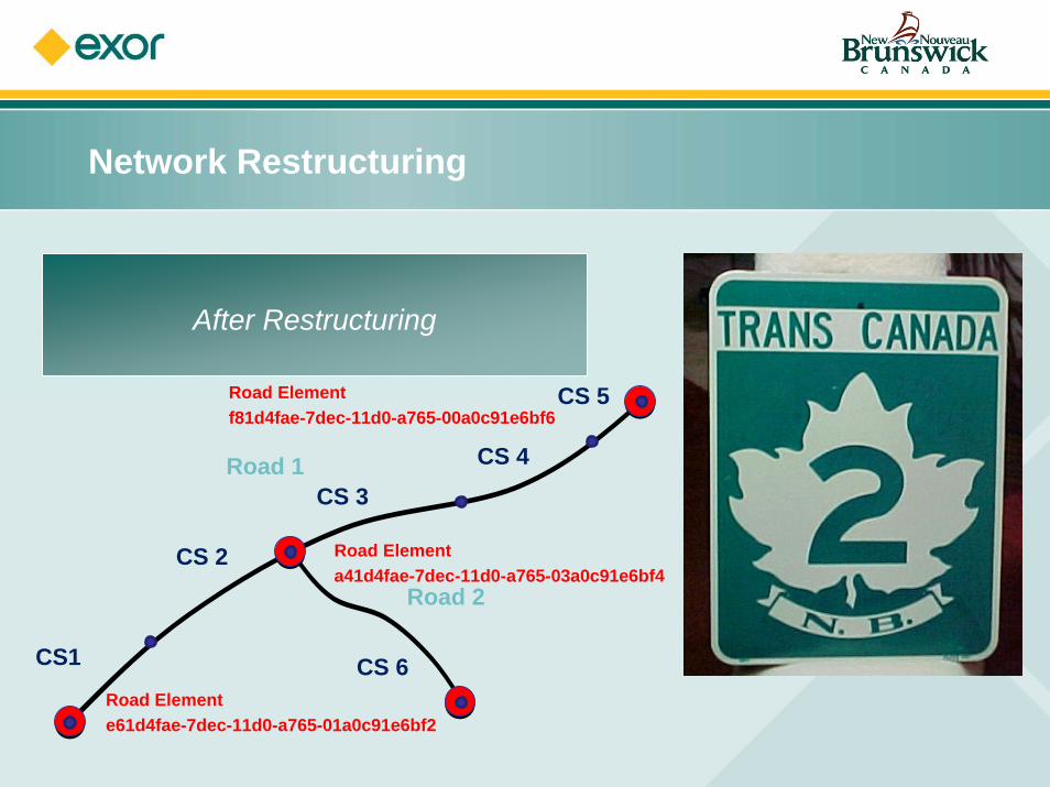
Network Restructuring
After Restructuring
Road 1
CS 2
CS1
CS 4CS 3
CS 6
CS 5
Road 2
Road Element f81d4fae-7dec-11d0-a765-00a0c91e6bf6
Road Element e61d4fae-7dec-11d0-a765-01a0c91e6bf2
Road Element a41d4fae-7dec-11d0-a765-03a0c91e6bf4

Network Restructuring
Precision Issues
3.15
3.15
3.15
9.45
3.15 rounds to 3.23.2 + 3.2 + 3.2 = 9.69.45 rounds to 9.5
Adding rounded numbers introduces inaccuracy

Network Restructuring
Cardinality Issues
C
A
B
Result of merging B to C then A to CB
Result of merging B to A then C to AB

Network Restructuring
Lessons• Network data can be restructured• Think it through first
• Sequence is everyting• Plan to test• Plan to rework

Thank you for your time. Any questions?
Marc KratzschmarExor Corporation
[email protected]+1 (619) 521 2594


![M. Hart - Implementing Freer Trade - The Canadian Experience 1986-1995 [IDB Paper]](https://static.fdocuments.in/doc/165x107/577d37a41a28ab3a6b9612fc/m-hart-implementing-freer-trade-the-canadian-experience-1986-1995-idb.jpg)


