Impacts of the Fundão Dam failure - portals.iucn.org · • Fishers community of Regência,...
52
Impacts of the Fundão Dam failure A pathway to sustainable and resilient mitigation RIO DOCE PANEL THEMATIC REPORT NO. 1 L.E. Sánchez, K. Alger, L. Alonso, F. Barbosa, M.C.W. Brito, F.V. Laureano, P. May, H. Roeser, Y. Kakabadse
Transcript of Impacts of the Fundão Dam failure - portals.iucn.org · • Fishers community of Regência,...

Impacts of the Fundão Dam failureA pathway to sustainable and resilient mitigation
RIO DOCE PANEL THEMATIC REPORT NO. 1
L.E. Sánchez, K. Alger, L. Alonso, F. Barbosa, M.C.W. Brito, F.V. Laureano, P. May, H. Roeser, Y. Kakabadse

B |
About IUCNIUCN is a membership Union uniquely composed of both government and civil society organisations. It provides public, private and non-governmental organisations with the knowledge and tools that enable human progress, economic development and nature conservation to take place together.
Created in 1948, IUCN is now the world’s largest and most diverse environmental network, harnessing the knowledge, resources and reach of more than 1,300 Member organisations and some 10,000 experts. It is a leading provider of conservation data, assessments and analysis. Its broad membership enables IUCN to fill the role of incubator and trusted repository of best practices, tools and international standards.
IUCN provides a neutral space in which diverse stakeholders including governments, NGOs, scientists, businesses, local communities, indigenous peoples organisations and others can work together to forge and implement solutions to environmental challenges and achieve sustainable development.
www.iucn.orghttps://twitter.com/IUCN/
i|
Impacts of the Fundão Dam failureA pathway to sustainable and resilient mitigation
L.E. Sánchez, K. Alger, L. Alonso, F. Barbosa, M.C.W. Brito, F.V. Laureano, P. May, H. Roeser, Y. Kakabadse
ii |
IUCN, Gland, Switzerland
© 2018 IUCN, International Union for Conservation of Nature and Natural Resources
Reproduction of this publication for educational or other non-commercial purposes is authorized without prior written permission from the copyright holder provided the source is fully acknowledged.
Reproduction of this publication for resale or other commercial purposes is prohibited without prior written permission of the copyright holder.
Sánchez, L.E., Alger, K., Alonso, L., Barbosa, F., Brito, M.C.W., Laureano, F.V., May, P., Roeser, H., Kakabadse, Y. (2018). Impacts of the Fundão Dam failure. A pathway to sustainable and resilient mitigation. Rio Doce Panel Thematic Report No. 1. Gland, Switzerland: IUCN.
978-2-8317-1935-1 (PDF)978-2-8317-1936-8 (print version)https://doi.org/10.2305/IUCN.CH.2018.18.en
NASA Earth Observatory image by Joshua Stevens, using Landsat data from the U.S. Geological Survey.
Diwata Hunziker
IUCN (International Union for Conservation of Nature)Global Business and Biodiversity ProgrammeRue Mauverney 281196 GlandSwitzerlandTel +41 22 999 0000Fax +41 22 999 0002www.iucn.org/resources/publications
Published by:
Copyright:
Citation:
ISBN:
DOI:
Cover photo:
Editing and layout by:
Available from:
The designation of geographical entities in this book, and the presentation of the material, do not imply the expression of any opinion whatsoever on the part of IUCN concerning the legal status of any country, territory, or area, or of its authorities, or concerning the delimitation of its frontiers or boundaries.
The views expressed in this publication do not necessarily reflect those of IUCN.
ii |

iii|
Figures and table
Foreword
Preface
Acknowledgements
Executive summary
Introduction
Paving the way to sustainable and resilient mitigation
A brief account of the disaster
The Rio Doce watershed and the coastal zone
Impacts of the Fundão Dam failure – The context
The responses
The intended outcomes and the impacts of mitigation
Enabling conditions for the delivery of sustainable and resilient mitigation
Moving forward – Seizing opportunities
Conclusions and recommendations – A road map
Epilogue
References
1
2
3
4
5
6
7
8
9
iv
v
vii
viii
ix
1
2
4
9
13
15
17
19
22
24
33
34
iii|
Contents
iii|
iv |
Figure 1. Samarco mine and affected localities in Gualaxo do Norte creek and Doce River
Figure 2. Marine area potentially affected by the surface tailings plume
Figure 3. The Rio Doce watershed and the coastal zone
Figure 4. Fundão Dam failure and its direct impacts
Figure 5. Contextual representation of the state of the affected environment as influenced
by the Fundão Dam failure, current and past human actions in the Doce
watershed, and measures to mitigate the impacts of the failure
Table 1. Recommended actions to address sustainability and resilience in mitigation
5
8
9
13
17
25
Figures and table

v|
Foreword
In 2015, the Fundão tailings dam collapse resulted in 19 deaths and untold damage to communities and the environment of the Rio Doce watershed. This report outlines the key steps to restoring health to this deeply damaged watershed, and, importantly, to the people who depend on its resources. It is the first in a series of reports to be issued by the IUCN-led independent Rio Doce Panel, established with the critical purpose of advising on recovery efforts following the disaster, and of helping prevent such catastrophes going forward. As the Rio Doce was already marred by pollution prior to the disaster, the Panel’s aim is to help restore the landscape, and the local communities, to a healthier and more sustainable state than before the accident occurred. To make this vision a reality, strong, integrated environmental management at all levels is key. Like most of the world’s watersheds, the Rio Doce faces increasing challenges connected to industrial pressures, lack of regulation, ecosystem degradation and climate change. Ensuring sustainable water stewardship by all stakeholders in the region is essential to restoring and maintaining local people’s food and water supplies, their health and livelihoods. Noting the importance of healthy ecosystems for resilient mitigation, the report highlights the vital role of nature-based solutions in the restoration efforts. For example, when the Rio Doce’s fishing ban eventually lifts, fisheries could quickly become threatened by overfishing if appropriate controls to ensure their sustainability are not in place. The future of the river’s fisheries will depend on institutions, government and communities, and the fishers themselves, to act responsibly and for the greater good. IUCN is confident that this important publication marks the beginning of a fruitful collaboration with the Renova Foundation and the region’s stakeholders, one that will result in profound, positive change for all those affected by the tailings dam collapse, their economy and environment.
Inger AndersenDirector GeneralIUCN, International Union for Conservation of Nature
vi |vi |
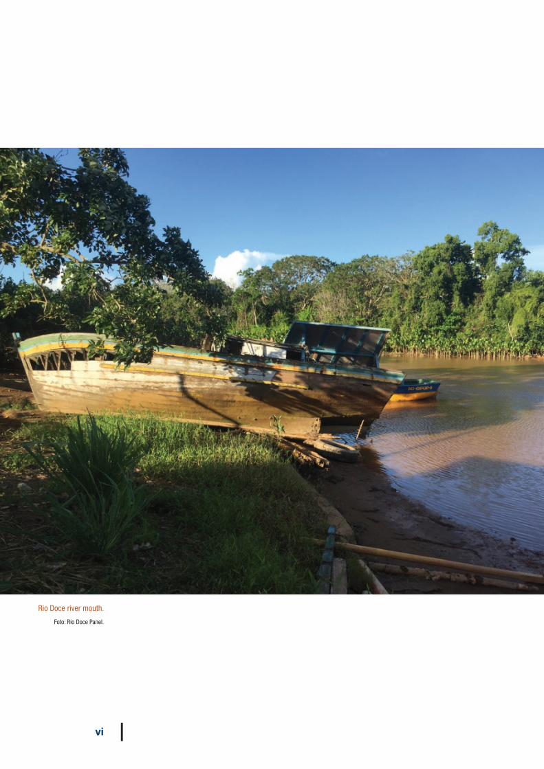
Rio Doce river mouth.
Foto: Rio Doce Panel.
vii|
IUCN is a recognised global authority on the status of the natural world and the measures needed to safeguard it. Since the early 2000s, it has established and managed a variety of Independent, Scientific and Technical Advisory Panels to deliver credible and robust advice to third parties in a manner that is transparent, accountable and scientifically rigorous.
Such IUCN-led panels openly engage stakeholders and publically share their recommendations. While each panel has its own unique focus, time-scale and mandate, they all adhere to the same basic principles: independence, transparency, accountability and engagement.
IUCN-led panels, such as the Rio Doce Panel, are not intended to be a substitute for dialogue or consensus building, nor are they suitable for addressing broad societal change. Instead, such initiatives are best suited to situations where a company, industry sector or government agency requires independent strategic advice, or where science-based guidance is required to determine the best course of action.
In the case of the Rio Doce Panel, Fundação Renova asked IUCN to convene a panel of international and national technical experts, which is currently chaired by Yolanda Kakabadse, a former IUCN President and Ecuadorian Minister of Environment. The panel’s mandate is to provide Fundação Renova with objective recommendations concerning the recovery of the Rio Doce basin, following the 2015 collapse of the Fundao tailings dam in Brazil. The panel’s work is, therefore, in addition to the on-going social and environmental programmes being carried out by the foundation.
Over the next few years, the Rio Doce Panel’s recommendations will cover a range of issues highlighted in a series of thematic reports and issues papers, based on what the Panel considers to be priority issues for the long-term recovery and rehabilitation of Rio Doce basin and adjoining coastal zone.
Thus, the aim of the Rio Doce Panel goes beyond restoring the watershed to its previous state before the disaster occurred. Its vision is to provide guidance that will help not only Fundação Renova, but key decision-makers and the numerous communities affected, build an integrated, nature-based and economically sustainable landscape that can serve as model for other watersheds. What follows is its first report.
Preface
vii|
viii |
The Rio Doce Panel is thankful to the following persons who provided meaningful information and shared their views on the disaster and the mitigation programmes, including:
• Representatives of local governments involved, especially the States of Minas Gerais and Espirito Santo, and the municipalities of Mariana, Rio Doce and Linhares;
• Representatives of environmental governmental agencies, especially SEAMA-ES (Secretaria de Estado de Meio Ambiente e Recursos Hídricos do Espírito Santo), SEMAD-MG (Secretaria de Estado de Meio Ambiente e Desenvolvimento Sustentável de Minas Gerais), ICMBio (Instituto Chico Mendes de Conservação da Biodiversidade) and IBAMA (Instituto Brasileiro do Meio Ambiente e dos Recursos Naturais Renováveis);
• Representatives of local non-governmental organizations, especially IBIO (Instituto BioAtlântica, Technical Secretariat of the Rio Doce Watershed Committee);
• Fishers community of Regência, especially Élcio José Sabino de Oliveira and Leônidas Carlos; and
• IUCN Members in Brazil who have contributed to the Panel’s work.
This report would not be possible without the support of the Fundação Renova, more specifically from Alan Rigolo, Guilherme Tangari and Roberto Waack.
Finally, thanks to the IUCN team providing ongoing technical support to the Panel, especially Stephen Edwards, Carolina Del Lama Marques, Maria Ana Borges, Julien Colomer and Leigh Ann Hurt.
viii |
Acknowledgements
ix|
Executive summary
On 5 November 2015, a large dam containing 52 million m3 of iron mining residues (tailings) collapsed in Mariana, Brazil. As a mud wave flowed through a narrow valley and quickly reached the locality of Bento Rodrigues, it destroyed several buildings, including houses and the heritage São Bento chapel. Sadly, 19 people lost their lives, 14 workers at the dam site and five inhabitants of the village, who were not warned in time. The mud wave travelled further downstream, affecting wildlife, riparian vegetation and other settlements before reaching Rio Doce, a river that flows eastwards to the Atlantic Ocean.
As it moved towards the sea, part of the tailings was trapped in the reservoir of a hydropower plant, hindering electricity generation. Further downstream, water supply of several towns was disrupted. The tailings eventually reached the ocean, 670 km away from the dam site, spreading a turbidity plume over a large area.
The collapse prompted both an emergency response, including assistance and compensation to affected people, and a short- and long-term set of mitigation measures structured in 42 programmes. These actions, determined by a group of government agencies, aim to restore and enhance the environmental quality and well-being of the affected populations.
Requirements and guidelines for mitigation were established as the end result of an out-of-court settlement signed on 2 March 2016, between the mine owner Samarco, its parent companies Vale and BHP, the Federal, and the Minas Gerais and Espírito Santo
State governments. These programmes are being implemented by a special-purpose entity, Fundação Renova, endowed by the parent companies and governed by a Board that includes representatives of the affected communities.
In the first of a series of publications, the independent Rio Doce Panel presents its views and recommendations for moving towards sustainable and resilient mitigation of the impacts of the dam failure. The key message from the Panel is: mitigation efforts should lead to a positive and lasting legacy for present and future generations.
Mitigation, in this context, is composed of three types of action: (i) remediating damage; (ii) restoring the biophysical environment and people’s livelihoods; and (iii) compensating for damage that cannot be remediated. Sustainable mitigation means that remediation and restoration actions should be conducted in such a way that causes minimum harm, and leads to self-sustaining solutions that enhance the quality of the environment and the livelihoods of affected communities. Compensation, on the other hand, is an interim action necessary only to the extent that – and during the period – the harmful impacts of the dam failure are not fully remediated, and ecosystems and livelihoods not restored. Resilient mitigation refers to solutions that can cope with current and future threats, especially climate change, as well as those that stem from the cultural and historical way the resources of the ecosystems have been used and degraded.In order to achieve sustainable and resilient mitigation, the Rio Doce Panel believes
ix|
x |
Rio Doce Panel Thematic Report No. 1
that a number of pre-requisites should be addressed. Equally, opportunities that arise from the effort and the resources mobilized for mitigation should be seized to improve the environmental quality and human well-being in the whole Rio Doce watershed and coastal zone, beyond the ongoing programmes. For example, the programmes being implemented by Fundação Renova inject financial and human resources to improve environmental quality in the watershed (e.g. sanitation), and can be used to leverage funds from other sources to help solve historical problems and facilitate the establishment of long-term mechanisms to continuously support restoration efforts and environmental protection.
The analysis conducted by the Rio Doce Panel resulted in the following recommendations:
1 Prepare a comprehensive assessment of the impacts of the dam failure and take into consideration, for each valued environmental and social component, the baseline at some point in the past and prior to the failure as well as trends in the state of those valued components;
2 Carry out an integrated evaluation of the outcomes of the mitigation programmes;
3 Identify threats to sustainability and resilience of mitigation outcomes, and address them;
4 Review regional climate change models and propose improvements in mitigation programmes to address risks to the achievement of outcomes;
5 Develop an adaptive management plan;6 Develop and implement a data and
information sharing plan; and7 Initiate and maintain actions to gather
and disseminate relevant information and knowledge.
These recommendations are primarily directed at Fundação Renova. However, addressing pre-existing impacts accumulated over time and space in the Rio Doce Basin and coastal zone requires more than successfully mitigating the impacts of the dam failure: actions by governments, citizens’ groups and private organizations are urgently needed to address the widely-recognized problems, such as sewage treatment and afforestation, as well as foreseeable challenges. Furthermore, once mitigation of the impacts of the dam failure is satisfactorily delivered, their positive outcomes need to be sustained and enhanced well beyond the mandate and, possibly, the existence of the Foundation.
Ultimately, the Rio Doce Panel believes that the Rio Doce remediation and restoration effort will become a reference case to be studied in the future and a model for the restoration of other river basins worldwide.
x |

1 | INTRODUCTION
1|
1 | Introduction
A disaster1 of major environmental, social and economic consequences started with the failure of a mine tailings dam in southeastern Brazil. The Fundão Dam – a massive tailings storage facility holding about 52 million m3 of fine and coarse-grained mineral particles resulting from processing iron ore at the mines owned and operated by Samarco, in the Mariana municipality, Minas Gerais State – collapsed on the afternoon of 5 November 2015. Samarco, who started its operations in the mid-1970s, is currently jointly owned by two of the largest mining companies in the world, Brazilian Vale and Anglo-Australian BHP.
Tailings dams are engineering structures designed to safely store the residues of mineral processing, an operation that concentrates the minerals containing the substances of interest (in this case, iron oxide minerals, mostly hematite) by separating them from other minerals. Processing ore requires crushing and grinding, producing fine enough grains to allow the physical or physical-chemical separation of ore from other minerals. While ore is used for further processing, often offsite, tailings are disposed of in the mine site.
Although designed to last for their operational life and beyond, after proper decommissioning, tailings dams (or other tailings storage facilities) occasionally
break, and such events happen much more frequently than with water dams. A history of accidents (Roche et al., 2017) and accumulated experience led to the development of good practice guidance focused both on prevention and risk reduction, as well as emergency preparedness and action.2
Technological risks (i.e. the potential environmental and social harm derived from man-made activities) are usually assessed to consider the likelihood of undesirable events and the magnitude of their consequences. After proper assessment, risk management and risk reduction actions target both at minimizing the probability of accidents and at preventing or minimizing harmful consequences. Risk management should be an ongoing task in mine tailings storage facilities, as risks may increase over time.
The Fundão Dam failure resulted in 19 fatalities, the displacement of more than 220 families, pollution and disruption of 670 km of river and a large oceanic area, among several other serious short- and long-term consequences.
As lawsuits continue and the responsible parties and governments act to mitigate the impacts, an Independent Scientific and Technical Advisory Panel was brought together by IUCN to provide constructive and
1 The term disaster used in this paper is defined by the Open-ended intergovernmental working group on terminology relating to disaster risk reduction as “a serious disruption of the functioning of a community or a society at any scale due to hazardous events interacting with conditions of exposure, vulnerability and capacity, leading to one or more of the following: human, material, economic and environmental losses and impacts …. The effect of the disaster can be immediate and localized, but is often widespread and could last for a long period of time. The effect may test or exceed the capacity of a community or society to cope using its own resources, and therefore may require assistance from external sources, which could include neighbouring jurisdictions, or those at the national or international levels.” (UNGA, 2016). In a nutshell, “disasters disrupt community functioning” (Phillips, 2016).2 A review commissioned after the Fundão Dam disaster by ICMM (International Council of Mining and Metals), an industry association, lists several guidance documents pertaining to mine tailings management (ICMM, 2016).

2 |
Rio Doce Panel Thematic Report No. 1
unbiased recommendations to the ongoing multi-institutional efforts to restore the disturbed environment and the livelihoods of affected communities.
In the first of a series of thematic reports and issue papers, the Panel presents its views on the challenges faced by both the Brazilian federal and state governments, businesses and communities to recover from the disaster. Since the aftermath of the event, emergency and short-term actions to mitigate the acute effects of the failure have been adopted. A detailed assessment of damages and remediation was initiated afterwards and is ongoing.
This report addresses the long-term challenges and builds on the opportunities arising from the governance structure set up to accomplish effective mitigation. Therefore, it focuses on the impacts of the Fundão Dam failure and its mitigation. The causes that led to the disaster and responsibilities are not part of the Panel’s scope.
In this light, this paper adopts an ecosystem approach3 and a landscape/seascape perspective that considers the cumulative effects of past, present and reasonably foreseeable future actions and factors on the environmental resources and the social and cultural values within a source-to-sea continuum.4 Cumulative effect is defined as “a change in the environment caused by multiple interactions among human activities and natural processes that accumulate across space and time” (CCME, 2014).
Paving the way to sustainable and resilient mitigation
The title of this paper, “Impacts of Fundão Dam failure — A pathway to sustainable and resilient mitigation”, reflects the key concern of the Panel: mitigation efforts should lead to a positive and lasting legacy for the present and future generations. Different terms are used in this paper to describe the actions being implemented after the disaster,which are collectively referred to as ‘mitigation’, in accordance with the terminology usually adopted in impact assessment (IAIA, 2013). Such mitigation focuses on the following objectives: (i) to remediate damage; (ii) to restore the biophysical environment to a desired previous state; (iii) to restore or enhance livelihoods of affected people; and (iv) to compensate for damage that cannot be remediated. It is acknowledged that such mitigation can, in certain circumstances, be the source of new impacts that should be treated according to the mitigation hierarchy, i.e. avoidance, minimization and compensation, in that order.
Sustainable mitigation implies that remediation and restoration should lead to equitable and lasting solutions to the problems arising from the dam failure. In other words, remediation and restoration actions should be conducted in a way that: (i) causes minimum harm, and (ii) leads to self-sustaining solutions that enhance the quality of the environment and the livelihoods of affected communities.
3 The definition for ‘ecosystem approach’ is based on the Convention on Biological Diversity (CBD), which is the basis of the guidelines used in IUCN, including the Commission on Ecosystem Management. For more information, please visit: https://www.cbd.int/ecosystem/publication and https://www.cbd.int/doc/publications/ea-text-en.pdf4 The notion of source-to-sea systems has been used to guide sustainability-oriented actions towards managing river basins and adjacent coastal and oceanic areas. As defined by Granit et al. (2017), “a source-to-sea system includes the land area that is drained by a river system, its lakes and tributaries (the river basin), connected aquifers and downstream recipients including deltas and estuaries, coastlines and near-shore waters, the adjoining sea and continental shelf as well as the open ocean.”
1 | INTRODUCTION
3|
Compensation is seen an interim, temporary action needed only to the extent that – and during the period – the harmful impacts of the dam failure are not fully remediated, and ecosystems and livelihoods not restored.
Resilient mitigation refers not only to those solutions that can cope with current and future threats, especially climate change, but also to those that stem from the cultural and historical way the resources of the ecosystems have been used and degraded.5 Of particular relevance to building resilience of socio-ecological systems is the adoption of nature-based solutions, defined as “actions to protect, sustainably manage and restore natural or modified ecosystems that address societal challenges effectively and adaptively, simultaneously providing human well-being and biodiversity benefits” (Cohen-Shacham et al., 2016).
This paper is organised into nine sections. A brief description of the disaster is presented in section 2, followed by a synthesis of the affected watershed and coastal zone in section 3. In section 4, it is defended that the environmental, social, economic and cultural impacts of the dam failure need to be understood in terms of their combined full extent in order to support effective mitigation. A summary description of mitigation actions undertaken by the responsible parties is presented in section 5. In section 6, the impacts of the Fundão Dam failure and corresponding mitigation are considered alongside other human actions that have been affecting the environmental quality of the watershed and the coastal zone.
The Panel’s understanding of the main needs to be considered in order to deliver sustainable and resilient mitigation are raised in section 7, while a number of opportunities resulting from the ongoing mitigation efforts are outlined in section 8. In the final section, the Panel presents its recommendations to address those needs and take advantage of opportunities in order to achieve sustainable and resilient mitigation of the impacts of the Fundão Dam failure.
5 There are several definitions of resilience and “multiple levels of meaning” (Carpenter et al., 2001), as the concept has been applied to different disciplines and contexts (Walker and Cooper, 2011). For socio-ecological systems, resilience is usually conceptualized as “the capacity of a system to undergo disturbance and maintain its functions and controls” (Carpenter et al., 2001) or “the capacity of a system to absorb disturbance and re-organize while undergoing change so as to still retain essentially the same function, structure and feedbacks, and therefore identity” (Folke, 2016).
4 |
Rio Doce Panel Thematic Report No. 1
2 | A brief account of the disaster
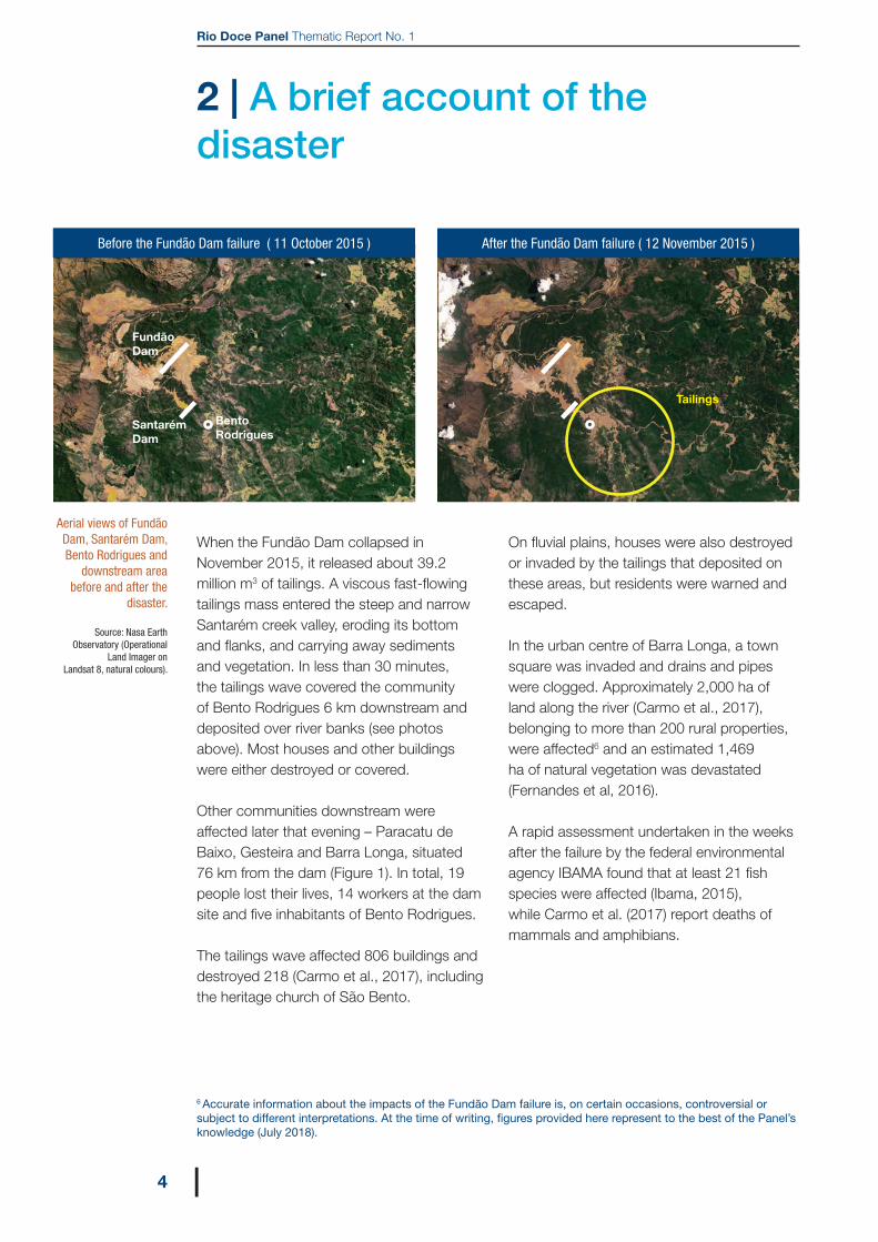
When the Fundão Dam collapsed in November 2015, it released about 39.2 million m3 of tailings. A viscous fast-flowing tailings mass entered the steep and narrow Santarém creek valley, eroding its bottom and flanks, and carrying away sediments and vegetation. In less than 30 minutes, the tailings wave covered the community of Bento Rodrigues 6 km downstream and deposited over river banks (see photos above). Most houses and other buildings were either destroyed or covered.
Other communities downstream were affected later that evening – Paracatu de Baixo, Gesteira and Barra Longa, situated 76 km from the dam (Figure 1). In total, 19 people lost their lives, 14 workers at the dam site and five inhabitants of Bento Rodrigues.
The tailings wave affected 806 buildings and destroyed 218 (Carmo et al., 2017), including the heritage church of São Bento.
On fluvial plains, houses were also destroyed or invaded by the tailings that deposited on these areas, but residents were warned and escaped.
In the urban centre of Barra Longa, a town square was invaded and drains and pipes were clogged. Approximately 2,000 ha of land along the river (Carmo et al., 2017), belonging to more than 200 rural properties, were affected6 and an estimated 1,469 ha of natural vegetation was devastated (Fernandes et al, 2016).
A rapid assessment undertaken in the weeks after the failure by the federal environmental agency IBAMA found that at least 21 fish species were affected (Ibama, 2015), while Carmo et al. (2017) report deaths of mammals and amphibians.
Aerial views of Fundão Dam, Santarém Dam, Bento Rodrigues and
downstream area before and after the
disaster.
Source: Nasa Earth Observatory (Operational
Land Imager on Landsat 8, natural colours).
6 Accurate information about the impacts of the Fundão Dam failure is, on certain occasions, controversial or subject to different interpretations. At the time of writing, figures provided here represent to the best of the Panel’s knowledge (July 2018).
After the Fundão Dam failure ( 12 November 2015 )
Tailings
Before the Fundão Dam failure ( 11 October 2015 )
Santarém Dam
Bento Rodrigues
Fundão Dam

2 | A BRIEF ACCOUNT OF THE DISASTER
5|
A substantial increase in suspended sediment loads in the affected rivers was accompanied by an increase in the concentration of dissolved metals in the water. Metals were highly enriched in sediments, including mercury largely used in the past artisanal gold mining (Hatje et al., 2017).
About 24.3 million m3 of mostly coarse grains, essentially composed of quartz and hematite, were either deposited in approximately 100 km of river between Fundão and Cadonga Dams or retained in its reservoir. Candonga Dam is a 140 MW power plant with a 30.8 million m3 reservoir which started operating in 2004. An estimated volume of 18.9 million m3 of mostly fine particles passed this concrete dam and reached the ocean, 670 km downstream, after 16 days, spreading over the coastal area (see photo).
Figure 1 Samarco mine and affected localities in Gualaxo do Norte creek and Doce River
Source: Fundação Renova.
View of Candonga reservoir upstream clogged with tailings (July 2016). A dredge can be seen in the lower right of the photo. Earthworks above the dredge were underway to transport dredged tailings to disposal sites.
Photo: © Felipe Werneck/Ascom/Ibama (CC BY 2.0)
6 |
Rio Doce Panel Thematic Report No. 1
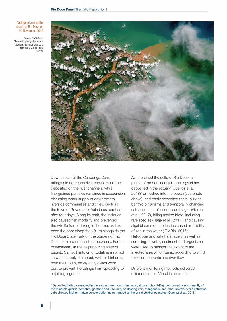
Tailings plume at the mouth of Rio Doce on
30 November 2015
Source: NASA Earth Observatory image by Joshua
Stevens, using Landsat data from the U.S. Geological
Survey.
Downstream of the Candonga Dam, tailings did not reach river banks, but rather deposited on the river channels, while fine-grained particles remained in suspension, disrupting water supply of downstream riverside communities and cities, such as the town of Governador Valadares reached after four days. Along its path, the residues also caused fish mortality and prevented the wildlife from drinking in the river, as has been the case along the 40 km alongside the Rio Doce State Park on the borders of Rio Doce as its natural eastern boundary. Further downstream, in the neighbouring state of Espírito Santo, the town of Colatina also had its water supply disrupted, while in Linhares, near the mouth, emergency dykes were built to prevent the tailings from spreading to adjoining lagoons.
As it reached the delta of Rio Doce, a plume of predominantly fine tailings either deposited in the estuary (Queiroz et al., 2018)7 or flushed into the ocean (see photo above), and partly deposited there, burying benthic organisms and temporarily changing estuarine macrofaunal assemblages (Gomes et al., 2017), killing marine biota, including rare species (Hatje et al., 2017), and causing algal blooms due to the increased availability of iron in the water (ICMBio, 2017a). Helicopter and satellite imagery, as well as sampling of water, sediment and organisms, were used to monitor the extent of the affected area which varied according to wind direction, currents and river flow.
Different monitoring methods delivered different results. Visual interpretation
7 Deposited tailings sampled in the estuary are mostly fine sand, silt and clay (74%), composed predominantly of the minerals quartz, hematite, goethite and kaolinite, containing iron, manganese and other metals, while estuarine soils showed higher metals concentration as compared to the pre-disturbance status (Queiroz et al., 2018).

2 | A BRIEF ACCOUNT OF THE DISASTER
7|
The tailings plume flowing from Rio Doce into the ocean on 24 November 2015. Regência can be seen on the left. Part of the Comboios Biological Reserve, a turtle nesting site, lies to the left (South) of Regência.
Source: Fred Loureiro/SecomES.
of satellite images made by the federal environmental agency IBAMA estimated that the tailings reached an area as large as 47,000 km2 (IBAMA, 2017; ICMBio, 2017b). This estimate is equivalent to the total area where the plume was observed during a 15-month period, irrespective of the time span the tailings stayed at each place, i.e. the instant distribution of the surface plume is smaller.
Visual monitoring by helicopter started the day after the plume reached the sea (see photo below). Different criteria were adopted to survey the plume’s limits – all based on naked eye colour differentiation, following guidance issued by the Espírito Santo environmental agency (IEMA, 2016). This monitoring showed a maximum extension
of the “dense” (high turbidity) plume to be about 1,400 km2 in December 2015, while a more diluted plume reached about 4,800 km2 (Econservation, 2017).
The affected area is situated mostly to the south of the river mouth (Figure 2) and up to 75 km offshore (Rudorff et al., 2018). The zone of higher turbidity is closer to the coast (20-30 km) and predominantly north of the mouth. Only the superficial plume could be monitored by using this method.
Having been finely ground at the mine, most particles are below 1 μm, which made it difficult to settle in the ocean. A strong cyclone that reached the region on 8 January 2016 inverted the coastal currents towards the north, spreading tailings up to

8 |
Rio Doce Panel Thematic Report No. 1
the Abrolhos Marine National Park in the neighbouring Bahia State (ICMBio, 2017a; Rudorff et al., 2018), an important protected area.
Part of an estimated volume of 12.9 million m3 of tailings that did not flush at dam’s break were slowly drained into the river system during the following rainy season, adding to the particles load and affecting water quality for a longer period. Containment dams were built to retain as much remaining tailings as possible, while a project for a definitive new dam was prepared and submitted for approval.8
Several other emergency actions were initiated by Civil Defence and other government agencies, as well as Samarco. Material support to affected families, temporary lodging and provision of potable water for the affected population downstream were some of the emergency actions. In the lower reaches, emergency dykes were built to avoid muddy waters from entering the lakes situated in the floodplain used as source of freshwater for Linhares.9
Figure 2a (left) Extent of the surface
plume as captured by helicopter naked-eye
observation in the period 11 November
2015 – 11 November 2016. The actual
extension of the plume at any time is smaller
or much smaller, because its position
and extension varies according to winds, ocean currents and
river flow.
Source: Fundação Renova, on the basis of instructions issued by IEMA (2016), as reported in Econservation
(2017).
Figure 2b (right)Maximum observed reach of the surface plume in the period
3 December 2015 –3 February 2017, as
captured by visual interpretation of
Acqua, Terrae and Suomi NPP satellite imagery. The actual
extension of the plume at any time is smaller
or much smaller, because its position
and extension varies according to winds, ocean currents and
river flow. Turbidity and particles concentration
also varies in space and time. The low
concentration plume may contain sediments
transported by other rivers flowing to
the ocean.
Source: IBAMA (2017).
Artwork by Mirna Ferracini.
S
LW
N
S
LW
VITÓRIA
BAHIA
ESPÍRITO SANTO
MINAS GERAIS
RIO DE JANEIRO
BAHIA
ESPÍRITO SANTO
MINAS GERAIS
RIO DE JANEIRO
50 25 0 50 km 50 25 0 50 km
Abrolhos NationalMarine Park
Protected areas
State limits
Major city
Plume as surveyed by helicopter
High concentration plume as obtained from visual interpretation of satellite imagery
Low concentration plume as obtained from visual interpretation of satellite imagery
VITÓRIA
At
la
nt
ic
O
ce
an
Ri o D o c e
Abrolhos NationalMarine Park
Ri o D o c e
At
la
nt
ic
O
ce
an
8 For more information on the consequences of the dam failure, please visit: http://www.ibama.gov.br/recuperacao-ambiental/rompimento-da-barragem-de-fundao-desastre-da-samarco/documentos-relacionados-ao-desastre-da-samarco-em-mariana-mg 9 Local stakeholders are claiming that the dykes, built as part of emergency response, should remain definitively in place, and are calling for reinforcement and other interventions to convert temporary into definitive structures. The Rio Doce Panel is reviewing the situation of Lake Juparanã, the largest of such lakes, and is preparing an Issue Paper on that matter.
Figure 2 Marine area potentially affected by the marine plume
3 | THE RIO DOCE WATERSHED AND THE COASTAL ZONE
9|
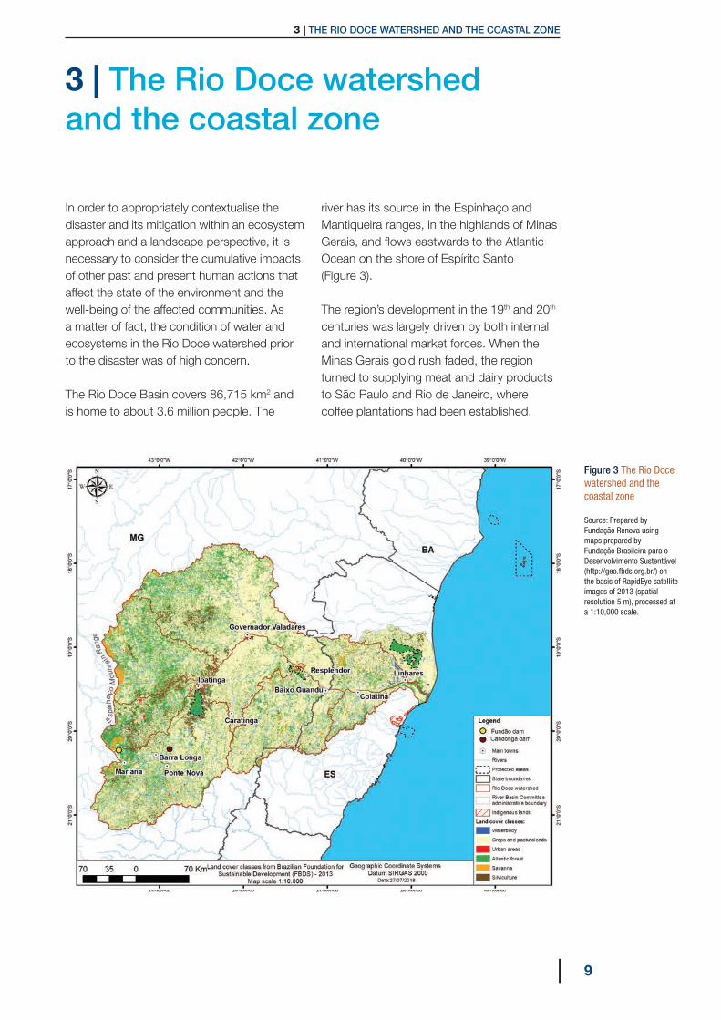
3 | The Rio Doce watershed and the coastal zone
In order to appropriately contextualise the disaster and its mitigation within an ecosystem approach and a landscape perspective, it is necessary to consider the cumulative impacts of other past and present human actions that affect the state of the environment and the well-being of the affected communities. As a matter of fact, the condition of water and ecosystems in the Rio Doce watershed prior to the disaster was of high concern.
The Rio Doce Basin covers 86,715 km2 and is home to about 3.6 million people. The
river has its source in the Espinhaço and Mantiqueira ranges, in the highlands of Minas Gerais, and flows eastwards to the Atlantic Ocean on the shore of Espírito Santo (Figure 3).
The region’s development in the 19th and 20th centuries was largely driven by both internal and international market forces. When the Minas Gerais gold rush faded, the region turned to supplying meat and dairy products to São Paulo and Rio de Janeiro, where coffee plantations had been established.
Figure 3 The Rio Doce watershed and the coastal zone
Source: Prepared by Fundação Renova using maps prepared by Fundação Brasileira para o Desenvolvimento Sustentável (http://geo.fbds.org.br/) on the basis of RapidEye satellite images of 2013 (spatial resolution 5 m), processed at a 1:10,000 scale.
Rio Doce Panel Thematic Report No. 1
10 |
In the course of this period, rural agricultural settlements established small cattle farms in unoccupied public lands, while coffee producers were also attracted by the still abundant fertile soils along the Doce River.In the upper portions of the basin, especially in the Piracicaba and Carmo tributaries, iron mining developed from the early 1900s. Steel mills followed, eventually leading to industrial concentration in the lower Piracicaba River, dubbed the “Steel Valley”. Transportation infrastructure was initially built along the river. The Vitória-Minas railway, whose construction started in 1903, contributed to the concentration of population and industry at short distances from the main river, often in flood-prone areas (ANA, 2013).
In the middle portion of the watershed, the construction of the major federal highway BR-116 in the 1960s led to significant population and economic growth, with the city of Governador Valadares emerging as the regional centre.
Hydropower was also developed where the highest potential was found, i.e. in Rio Doce itself, in addition to its tributaries Piracicaba and Santo Antonio. There are 10 hydropower plants, out of which four are on Rio Doce, and 16 small power plants operating in the basin. Several other small plants are planned (ANA, 2015).
Freshwater ecosystems were severely degraded due to the pressure of a range of human activities, in particular the inadequate treatment of sewage discharged (Hatje et al., 2017). The watershed comprises 225 municipalities, 93% of which have less than 20,000 inhabitants. It is estimated that 70% of the population receive treated water, while only 58% have sewage collection. However, only a small fraction of sewage receives some sort of treatment and 191 towns discharge all their sewage untreated (Consórcio Ecoplan/Lume, 2010).
Siltation is significant in most tributaries, with severe consequences on fish habitat. Soils are highly erodible. It is estimated that 58% of the basin area feature high erosion potential, while 30% feature moderate erosion potential (ANA, 2013). As a consequence, intense soil loss loads considerable volumes of sediments in river systems to a point that Candonga Dam had been receiving about 1 million m3 of sediments every year, while at the mouth, Rio Doce discharges an average of 11 million m3 of sediments every year, a very high figure if compared to the sediment discharge of other major rivers in the Eastern Atlantic (Lima et al., 2005).
Records show the occurrence of more than 100 native fish species in the Rio Doce Basin (Fernandes et al, 2016), of which 11 are threatened with extinction (Vieira, 2009). However, 28 exotic species were also detected (Vieira, 2009), increasing pressure on native fish diversity, also threatened if all planned hydroelectric dams are constructed. The widespread introduction of exotic species is an important cause of fish extinction, as demonstrated by a recent study by Fragoso-Moura et al. (2016) about the local extinction of seven fish species from a natural lake within the Rio Doce State Park – a Ramsar site – due to the introduction of non-native fish.
Natural vegetation cover was severely reduced and fragmented during the late 19th and early to mid-20th centuries. Development of iron ore mining from the 1940s onwards in its upper reaches and the construction of steel mills contributed to population growth and urban expansion alongside Rio Doce itself and especially its tributary Rio Piracicaba, while deforestation continued to expand in the basin’s slopes to produce timber and charcoal, as well as to sustain a predominantly rural economy in the easternmost portion of Rio Doce basin. Currently, remaining natural vegetation is essentially secondary regrowth in former pasture or croplands. Land cover in the
3 | THE RIO DOCE WATERSHED AND THE COASTAL ZONE
11|
catchment is predominantly pasture or crop (64%) (Consórcio Ecoplan/Lume, 2010), while estimates of the percentage of forest are highly variable and dependent on the criteria adopted and mapping method.
Long-term average water flow at Colatina hydrographic station (30-year series) varies from 1,700 m3 per second in December to 300 m3 per second in August-September. A trend to lower minimum flows was detected at this station (Coelho, 2006), and consecutive severe drought years were recorded in 2010−11 and 2015−16 (Rudorff et al., 2018). During peak flows (lastly observed in 1979 and 2013), the river overflows in the delta region, flooding agricultural areas.
The coastal zone near the mouth of Doce River is characterized by lowlands, the fluvial-marine plain featuring several lakes. The beaches are extensive, associated with frontal sand dunes. In general, the coast of Espírito Santo is prone to retrograde, with the exception found in the vicinity of river mouths, where the greater contribution of terrigenous sediments and the effect of the hydraulic jetty, developed by the fluvial flow, benefit the coastal line’s development in the medium and long term (Albino et al., 2006). Situated on opposite sides of Rio Doce at its mouth, the beach of Povoação experiences erosion during the arrival of cold fronts, while the beach of Regência experiences deposition, forcing the shoreline to move towards the ocean.
The continental shelf facing Espírito Santo features two physiographic compartments. The Bahia Sul-Espírito Santo platform, extending from Belmonte to Regência and averaging 230 km in width, and the narrower Tubarão platform, south of Regência, which is 50 km in width. The sediments transported by the river tend to deposit in the inner shelf. Fine sediments are deposited to the south of the river mouth up to a depth of 30 m.
However, storm events associated with winds from south-southeast mobilize these sediments and transport them to the north (Quaresma et al., 2015).
Human settlements along the river comprise several medium- and small-size towns, as well as rural communities and two indigenous lands. The biggest cities, upstream to downstream, are Ipatinga (261,000 inhabitants, situated in the confluence of Piracicaba and Doce Rivers), Governador Valadares (281,000 inhabitants), Colatina (124,000 inhabitants) and Linhares (169,000 inhabitants).
Four indigenous communities live in demarcated territories situated in the affected area: the Krenak, whose land borders Doce River in Resplendor municipality, and the Tupiniquim and Guarani, who live in the Caieiras Velhas II, Comboios and Tupiniquim lands, on the coast, south of the mouth of Rio Doce. About 350 Krenak live in their 4,040 ha land, while the coastal indigenous lands shelter about 3,000 Guarani and Tupiniquim. Definitive official land rights were granted to the Krenak in 2001, while the definitive official recognition acts for other lands were signed in 2011. Their nearby lands encompass 3,872 ha (Comboios) and 18,104 ha (Tupiniquim), and 57 ha for the Caieiras Velhas II area.
In the Rio Doce watershed, 40 municipalities are situated along the river. Social and economic indicators for those municipalities show a heterogeneous picture. Using a social exclusion index developed for the Brazilian context (Guerra et al., 2014)10, no municipality was found to be in the worst condition, eight municipalities present poor social conditions, 28 municipalities are in the middle range and four municipalities appear in the upper range, presenting good conditions. However, authors of the study do not provide calculations of this index for smaller territorial units, such as community

Rio Doce Panel Thematic Report No. 1
12 |
or neighbourhood (setor censitário in the official terminology of the Brazilian statistics agency IBGE).
Several rural properties situated along the Gualaxo do Norte creek (Figure 2) were affected either by deposition of tailings or by limited access to water. Most such properties along this river are small and run by family farmers. An estimated 88% of the properties are smaller than 20 ha. In other sectors of the watershed, and along the main course of the Rio Doce, there is a predominance of large properties that encompass roughly 80% of the catchment area. Agricultural and cattle production are aimed at both market and subsistence purposes. Among the most important products are milk and beef. Eucalyptus plantations for pulp production are important in parts of the watershed and near the river mouth (although not in the Doce catchment, but in neighbouring small coastal river basins).
At the river mouth and adjacent coastal zone, artisanal fishing (on a commercial basis) is a vital activity. The communities of Regência (approximately 1,100 inhabitants) and Povoação (approximately 1,600 inhabitants), respectively on the right and left banks, are fishing communities where beach-related tourism activities have developed at a small scale.
On the coast, there is a set of protected areas (Figure 3) where the ocean and the coastal zone are considered as one of the most biodiverse in the South Atlantic, which include coral reefs, a part of which are protected in the Abrolhos National Park, another Ramsar site.
At this point, it is important to stress that the impacts of the Fundão Dam failure added to and interacted with persistent effects of past and present human actions. If identifying the acute and immediate effects of tailings dispersal is relatively straightforward, differentiating its chronic and long-term effects is no easy task. This is one reason why mitigation, if it is to be sustainable and resilient, needs to address not only both the direct and indirect effects of the Fundão Dam failure, but also other pressures that affect the environmental quality of the basin and the well-being of its populations.
10 The social exclusion index (SEI) builds and expands on the well-known human development index. It has seven components (and corresponding indicators): formal employment (percentage of workers), poverty (considered as income below half Brazilian minimum wage), social inequality (using Gini index), literacy, schooling (percentage of adult population that concluded high school), youth proportion (percentage of the population under 19) and violence (homicide rate). SEI ranges from zero to one. However, in its applications to Brazil, Guerra et al. (2014) established four interval ranges: 0.25-0.45 / 0.45-0.56 / 0.56-0.68 / 0.68-0.84. The higher the index, the better the social condition is of the population. The data to calculate the index of each municipality are sourced from official socio-economic databases, in particular the Brazilian Institute of Geography and Statistics (IBGE – Instituto Brasileiro de Geografia e Estatística).
4 | IMPACTS OF THE FUNDÃO DAM FAILURE – THE CONTEXT
13|
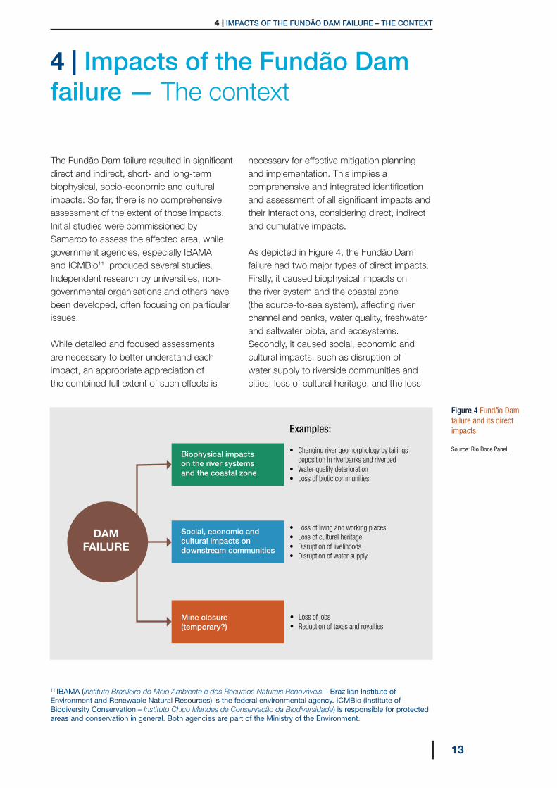
4 | Impacts of the Fundão Dam failure — The context
The Fundão Dam failure resulted in significant direct and indirect, short- and long-term biophysical, socio-economic and cultural impacts. So far, there is no comprehensive assessment of the extent of those impacts. Initial studies were commissioned by Samarco to assess the affected area, while government agencies, especially IBAMA and ICMBio11 produced several studies. Independent research by universities, non-governmental organisations and others have been developed, often focusing on particular issues.
While detailed and focused assessments are necessary to better understand each impact, an appropriate appreciation of the combined full extent of such effects is
necessary for effective mitigation planning and implementation. This implies a comprehensive and integrated identification and assessment of all significant impacts and their interactions, considering direct, indirect and cumulative impacts.
As depicted in Figure 4, the Fundão Dam failure had two major types of direct impacts. Firstly, it caused biophysical impacts on the river system and the coastal zone (the source-to-sea system), affecting river channel and banks, water quality, freshwater and saltwater biota, and ecosystems. Secondly, it caused social, economic and cultural impacts, such as disruption of water supply to riverside communities and cities, loss of cultural heritage, and the loss
Biophysical impacts on the river systems and the coastal zone
Social, economic and cultural impacts on downstream communities
Mine closure (temporary?)
DAM FAILURE
• Changing river geomorphology by tailings deposition in riverbanks and riverbed• Water quality deterioration• Loss of biotic communities
• Loss of jobs• Reduction of taxes and royalties
• Loss of living and working places• Loss of cultural heritage• Disruption of livelihoods• Disruption of water supply
Examples:
Figure 4 Fundão Dam failure and its direct impacts
Source: Rio Doce Panel.
11 IBAMA (Instituto Brasileiro do Meio Ambiente e dos Recursos Naturais Renováveis – Brazilian Institute of Environment and Renewable Natural Resources) is the federal environmental agency. ICMBio (Institute of Biodiversity Conservation – Instituto Chico Mendes de Conservação da Biodiversidade) is responsible for protected areas and conservation in general. Both agencies are part of the Ministry of the Environment.

Rio Doce Panel Thematic Report No. 1
14 |
of hydrogenerating capacity of Candonga power station and halting fishing by artisanal fishers near the river mouth and in Rio Doce itself, where only exotic species are allowed to be fished. The failure led to the immediate cessation of Samarco’s mining and ore processing with the ensuing loss of jobs and tax payments, thus reducing the revenue of municipalities dependent on mining and mineral processing.
A focus on a local scale shows that the impacts were unevenly distributed in the affected area. Communities were affected in many ways, headwaters to the coast, with Bento Rodrigues holding the burden of total destruction and loss of human lives, while along the river and at its mouth, the livelihoods of indigenous Tupiniquim and other communities were disrupted by degradation of water quality and fishing ban. In the large cities of Governador Valadares and Colatina, thousands of people faced serious water shortage and endured queues to be supplied with potable water.
Socio-economic impacts related to the mine closure were highly publicized, as almost 2,000 workers were laid off both in Mariana and Anchieta, the coastal areas where ore is agglomerated in pellets for overseas shipping. In Mariana municipality, Samarco mine was large enough to foster a pronounced dependency on taxes collected from the mining company as well as from suppliers and other service providers. In addition, according to Samarco’s estimates, its operation before the dam failure powered around 10,000 indirect jobs.
Indirect impacts are also noteworthy. Lost jobs and decreased household income in Mariana and Anchieta also reflected in local businesses’ decreased sales. Other Indirect socio-economic impacts downstream include
the virtual disappearance of the tourism industry in Regência, situated right at the mouth of Rio Doce.
These are just a few cases showing that the consequences of the Fundão Dam failure should be understood in the context of multiple spatial and temporal scales.
On a temporal scale, for example, the Candonga Hydropower plant had to stop generating electricity for more than two years. This brought to a halt the royalties linked to the revenue obtained by the plant operator in the small municipality of Rio Doce, which was partly flooded by the reservoir. Once a sufficient volume of tailings is dredged from the reservoir and the power plant operates again, this impact will be reverted. Other temporary social impacts are those – adverse and beneficial – associated with restoration, remediation and compensation, such as disturbance to communities situated in the areas where there are ongoing remediation and reconstruction works, and increased household revenue due to jobs created to implement those actions.
While impacts vary in intensity, spatial and temporal as well as social distribution, and reversibility, some impacts remain insufficiently understood because the baseline prior to the dam failure was poorly known12 and existing information is fragmented.
The Panel understands that, in addition to the studies that have been carried out, it is necessary to prepare a comprehensive assessment of the impacts of the dam failure considering, for each relevant valued environmental and social component, the baseline at some point in the past prior to the failure as well as trends in the state of those valued components.13
12 The state of ecological knowledge is variable along the source-to-sea continuum. There is existing limited information for the whole watershed except data from the Long-Term Ecological Research Programme (Brazil LTER/CNPq) on the ecosystems of the Rio Doce State Park at the middle stretch and its surroundings which has been providing invaluable information (e.g. Fragoso-Moura et al., 2016; Ottoni et al., 2011; Maia-Barbosa et al., 2010).13 The term ‘valued environmental and social component’ is largely used to frame the assessment of cumulative effects or impacts (IFC, 2013; Broderick et al., 2018).

5 | THE RESPONSES
15|
5 | The responses
The collapse of the Fundão Dam prompted both emergency response, including assistance and compensation to affected people, and a short- and long-term set of mitigation measures structured in 42 mitigation programmes. These actions aim at restoring and enhancing environmental quality and the well-being of affected populations and are directed by different government agencies.14
Guidelines for mitigation were established as a result of an out-of-court settlement reached between Samarco and its parent companies – Vale and BHP – and the Federal and State governments on 2 March 2016. Known as ‘Terms of Transaction and Conduct Adjustment’, or TTAC15 in its Portuguese acronym, this document defines the obligations of Samarco, covering not only all affected areas and communities, but also including actions to be implemented in surrounding areas or other sectors of the watershed. Examples of such programmes include resettling affected families of Bento Rodrigues, Paracatu de Baixo and Gesteira,
which contain tailings deposited in river banks, dredging tailings retained in the Candonga Dam, restoring 40,000 ha of native forest, restoring 5,000 water springs, constructing two rescue centres for wildlife, assisting affected rural producers to restore their livelihoods, and investing BRL 500 million in sewage collection and treatment and solid waste management.
Due to the multi-jurisdictional nature of government agencies’ legal competencies, an innovative arrangement was negotiated by the key responsible agencies to establish an “Inter-Federative Committee”, or CIF in its Portuguese acronym.16 CIF is composed of 11 “Technical Chambers”, where representatives of 70 government agencies (federal, state and municipal) meet to prepare guidance for the implementation of the 42 programmes. CIF, upon recommendation of its Technical Chambers, steers actions to be developed by Fundação Renova, a private foundation established in August 2016 to implement mitigation measures.17
Fundação Renova is funded by Samarco and
Banks of Gualaxo do Norte creek, upstream of Barra Longa, one of the locations where tailings deposited. Remedial action in this area aims at stabilizing margins to reduce bank erosion and additional transport of tailings in the rainy season. The photo was taken two months after tailings were recovered with a degradable blanket and seeded with grass, after which planting of tree seedlings was planned. A passage for cattle can be distinguished in the background.
Photo: © Luis E. Sánchez.
14 The programmes are described in https://www.fundacaorenova.org/en/discover-the-programs/. A short progress report is available for each programme along with technical reports.15 TTAC – Termo de Transação e de Ajustamento de Conduta. For further information, please visit: www.samarco.com/en/plano-de-recuperacao-macro/16 The committee is chaired by the Ministry of the Environment.17 For further information, please visit: www.fundacaorenova.org

Rio Doce Panel Thematic Report No. 1
16 |
Candonga Dam viewed from upstream (September 2017). The water is visibly loaded
with fine sediments. Dredging works were
underway.
Photo: © Luis E. Sánchez
18 On 25 June 2018, a new terms of agreement was signed by Samarco, its parent companies and the Prosecutors’ Offices introducing changes in the governance of Fundação Renova Foundation, This new document does not change the ongoing mitigation programmes, but responds to enduring criticism that “regarding the institutional makeup of the Foundation, no specific mechanism or provisions were included to ensure the effective participation of the affected communities in the decision-making process of the design and execution of the programs envisioned In the Agreement” [the TTAC] (Tuncak, 2017). The process of establishing the TTAC is also criticized by this same author, who is the United Nations Special Rapporteur on human rights and hazardous substances and wastes: “regarding the process by which the Agreement was negotiated between the public authorities and the Companies, there was minimal consultation with those impacted or affected by the catastrophe, in particular the communities living near the tailings dam rupture, those located downstream, and the indigenous populations living near the Rio Doce riverside. (…) The Agreement was reached in less than eight weeks, an extremely short time frame for an environmental disaster of this magnitude.” (Tuncak, 2017).
its parent companies, and governed by a Board of Trustees comprising members of the companies and a representative from CIF.18
Another task of CIF is to monitor the programmes’ implementation and evaluate their outcomes. The committee also issues detailed terms of reference for the programmes and, where applicable, sub-programmes. Technical support to CIF is provided by government agencies according to their respective legal competencies, e.g. Indigenous Affairs, Human Rights and others. However, as many such competencies overlap, especially in terms of federal and state action, CIF provides a forum for settling differences. Yet, supervising remediation actions remain largely the responsibility of each agency.
A number of such remediation actions require administrative approval, including an environmental licence issued either by the federal agency IBAMA or by the environmental agency of each State. For example, resettling the Bento Rodrigues community depends on a license granted by the Minas Gerais environmental agency. In addition, it needs to meet municipal regulatory requirements. Construction at the resettlement site started in early July 2018.
In contrast, a licence for dredging tailings in the Candonga reservoir was granted on an emergency basis (see photo above).
In dealing with man-made disasters, authorities are compelled to provide a quick and consistent response, and demonstrate accountability to an outraged public opinion. In the Rio Doce case, priority actions include containing tailings remaining in the mine area (not flushed when the dam broke), as well as tailings deposited in river channel and overbanks downstream, to reduce their continuous influx into the river system. Resettlement of Bento Rodrigues, including rescuing personal objects, excavating the ruined church with archaeological methods and cataloguing all artefacts, were also priority actions (see photo left).
By adopting a landscape perspective, the impacts of the Fundão Dam failure and corresponding mitigation should be considered alongside other human actions that have been affecting the environmental quality of the watershed and the coastal zone. Whether or not these responses (i.e. the outcomes of the 42 programmes) are effective is a key concern of all stakeholders.
Processing artefacts excavated in Bento
Rodrigues for cataloguing, storage and future return to
the community is an ongoing compensation
measure.
Photo: © Luis E. Sánchez.
6 | THE INTENDED OUTCOMES AND THE IMPACTS OF MITIGATION
17|
6 | The intended outcomes and the impacts of mitigation
Repairing damage and restoring the affected ecosystems and livelihoods of concerned communities is the overall aim of mitigation actions. However, it is also necessary to consider that the delivery of successful mitigation could bring about new harmful impacts.
As a matter of fact, both emergency actions (including regulatory response), as well as remediation, restoration and compensation programmes are themselves sources of other adverse environmental and social impacts (that is why many of them require an environmental license). For example, impacts from remediation works range from nuisance due to dust and noise from machinery work
during removal of tailings near houses in Barra Longa to land uptake for disposal of tailings dredged from the Candonga reservoir. The photo next page illustrates how a remedial action can adversely impact cultural heritage.
Other examples of adverse impacts from regulatory response include the disruption of fishers’ communities due to the fishing ban in the the river and at its mouth.19 Because they are not allowed to maintain their traditional activity, the cultural significance of fishing-related activities is in jeopardy for the duration of the ban. The monthly compensatory programme extended by Fundação Renova has attracted outsiders hoping to qualify for
19 The Panel is preparing an Issue Paper about fishing in the Rio Doce.
DAM FAILURE
Other past and present human actions affecting the watershed and coastal zone
By repairing damages and restoring ecosystems and livelihoods, it is expected that the state of the affected environment will improve – but these actions are also sources of new impacts.
PRESSURE IMPACT STATE RESPONSE
RESTORATION
COMPENSATION
BIOPHYSICAL IMPACTS
SOCIAL IMPACTS
REMEDIATION
MITIGATIONPROGRAMMES
Figure 5 Contextual representation of the state of the affected environment as influenced by the Fundão Dam failure, current and past human actions in the Doce watershed, and measures to mitigate the impacts of the failure
Source: Rio Doce Panel.
Rio Doce Panel Thematic Report No. 1
18 |
indemnification payments.Emergency actions, such as the interruption of the natural flow between Lake Juparanã and Rio Doce, can also represent a threat to ecosystems if they become perennial without appropriate prior assessment of their impacts.
These are evidences that any mitigation action needs to be carefully planned, discussed with the full array of stakeholders (Tuncak, 2017) and, as much as possible, scientifically based (Philips, 2016).
The biophysical and social environment affected by the dam failure is also influenced, and largely degraded, by past and current human actions taking place not only in the directly affected areas, but also in the river basin and the coastal zone.
As a consequence, these other actions can hamper the effectiveness of mitigation. While mitigation conducted by Fundação Renova focuses on remediating, restoring or compensating the impacts of the Fundão Dam failure, additional sustainability-oriented watershed- and landscape/seascape-scale mitigation may be needed to make such efforts sustainable and resilient. These are addressed in the next section.
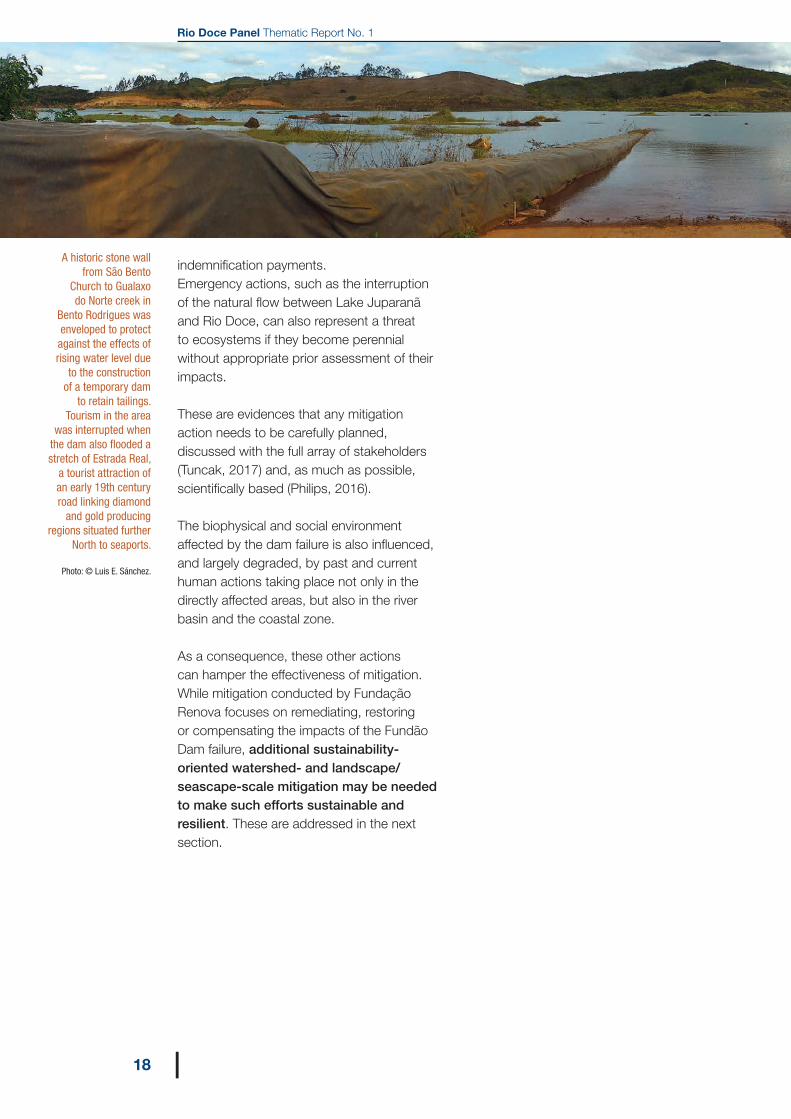
A historic stone wall from São Bento
Church to Gualaxo do Norte creek in
Bento Rodrigues was enveloped to protect against the effects of rising water level due
to the construction of a temporary dam
to retain tailings. Tourism in the area
was interrupted when the dam also flooded a stretch of Estrada Real,
a tourist attraction of an early 19th century road linking diamond
and gold producing regions situated further
North to seaports.
Photo: © Luis E. Sánchez.
7 | ENABLING CONDITIONS FOR THE DELIVERY OF SUSTAINABLE AND RESILIENT MITIGATION
19|
7 | Enabling conditions for the delivery of sustainable and resilient mitigationIt is not the purpose of this thematic paper to assess the effectiveness of the 42 programmes. Fundação Renova set up an internal quality assurance mechanism and is advised by external auditors on this matter, and reports to CIF and its agencies that are statutorily entitled to evaluate outcomes and require revisions, as needed. What is addressed in this section is a broader, landscape/seascape and long-term perspective that the Rio Doce Panel advocates as essential to achieve sustainable and resilient mitigation. For this purpose, the prerequisites described below must be appropriately addressed.
7.1 Consider the cumulative impacts of human activities in a landscape/seascape context. The ecosystems and human well-being at Rio Doce and the coastal zone that were severely affected by the Fundão Dam failure were hitherto under stress due to an aggregation of historical and current pressures. In this regard:
7.1.1 Measures to restore the biophysical environment directly affected will be effective only if other actions eliminate or reduce the stress factors. For example, autochtonous fish communities are declining due to extensive historical deforestation, construction of dams, water pollution, overfishing and introduction of exotic species. Fish populations were harmed by the tailings, but direct mitigation that could be carried out, such as translocation of native freshwater biota from other sectors of the watershed, can be ineffective if other actions do not tackle the
pre-existing causes of decline of native fish populations.
7.1.2 What baseline should be considered to establish restoration targets? Should remediation aim at re-establishing the conditions of environmental components immediately before the dam failure? Or should the mitigation effort also be directed at pooling financial and human resources with other initiatives and sources aiming at restoring or improving life-support systems at watershed level?
7.1.3 What future time frame should be considered to evaluate effectiveness of mitigation? To be lasting, efforts are needed to take account of current and future threats, especially climate change (see 7.5).
7.2 Adopt a multi-scale and multi-temporal approach to guide mitigation. In order to take account of cumulative impacts, it is necessary to agree with stakeholders, especially with regulators, on the most appropriate time and spatial scales to (i) assess the actual impacts of the dam failure; and (ii) define remediation and restoration targets and corresponding time schedules.
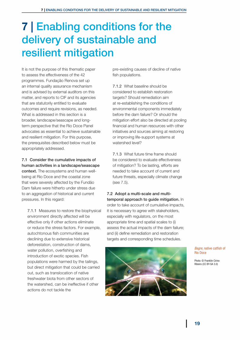
Bagre, native catfish of Rio Doce Photo: © Franklin Cirino Ribeiro (CC BY-SA 3.0)

Rio Doce Panel Thematic Report No. 1
20 |
7.3 Evaluate the outcomes of mitigation actions in an integrative way. Each programme follows its own rationale and has to conform to specific legal requirements and conditions defined by its respective government agency. So far, progress in implementing the programmes is uneven. Fundação Renova reports on a monthly and annual basis on the progress of each programme to CIF, and disseminates information through its website and other media. In addition, there is an independent audit of each programme. Notwithstanding, there is a need to evaluate outcomes not only on an individual basis because of unavoidable overlap or synergies between some programmes. For example, four programmes directly aim at benefitting rural properties, including “Resumption of agricultural and livestock activities”, “Recovery of permanent preservation areas”, “Springs recovery”, and a programme of support to the Rural Environmental Registry (CAR) and the implementation of the Environmental Adjustment Programmes (PRAs) of rural properties.
7.4 Assess the sustainability and the resilience of mitigation outcomes. When each programme fully meets its goals, it is necessary to consider the conditions required to maintain its achievements as well as its ability to withstand external pressures without collapsing sometime in the future. For example, restoring springs may achieve its objectives after native vegetation thrives and is protected against cattle invasion; however, if the benefits of protecting springs are not fully appreciated by landowners and farmers, and actually ‘bought-in”, they will not be perennial. Hence, it is necessary to identify the threats to sustainability and resilience of each programme and address those threats.
7.5 Take climate change into account. Adopting a landscape/seascape perspective requires a long-term inter-generational perspective. Climate change is one the most significant threats to human activity
and requires locally- or regionally-based adaptation strategies. If climate risks are not adequately factored into mitigation design, its long-term goals may be in jeopardy. However, no consideration of climate change has been incorporated into the 42 ongoing programmes. Climate change could affect the outcomes of mitigation in several ways, such as longer drought periods affecting the success of spring restoration or very intense rainfall destabilizing tailings contained in the banks of Gualaxo do Norte creek.
7.6 Address and/or account for uncertainties related to mitigation outcomes. Several factors can threaten the mitigation programmes and hinder the attainment of their objectives. Those factors can include poorly known baselines, insufficient knowledge base used to design the programme, problems faced during implementation, lack of acceptance by stakeholders and external factors such as climate change. Adaptive management may be necessary to address unforeseen situations that may prevent the programmes from achieving their goals or may require the goals to be redefined.
7.7 Make data and information available and accessible to a wider audience. An enormous amount of data and information are being generated during the remediation process. Such data and information are being stored at government agencies, consultancy firms and Fundação Renova. It was said that after the disaster, Rio Doce is the “best monitored” river in the country. Monitoring is not made for its own sake, but in support of management and decision-making. In addition, data and information can be exploited for a variety of purposes, such as scientific research, watershed management and land-use planning. Consequently, a plan to make data publicly available should be developed in consultation with relevant government agencies and the scientific community.
7 | ENABLING CONDITIONS FOR THE DELIVERY OF SUSTAINABLE AND RESILIENT MITIGATION
21|
7.8 Draw on lessons learned and disseminate them. Dealing with a disaster of such a scale and extensive consequences required and still requires ingenuity, negotiation and profound involvement of stakeholders. Enduring the consequences of the disaster and recovering from it, as well as adapting to the new post-disaster situation, enables experiential learning at individual, social, and organisational levels. From affected individuals and communities to several government departments to civil society organizations and interested persons who became involved, many lessons were certainly learned. They should be shared. For example, to implement forest restoration actions, it is necessary to engage small and often ageing rural producers and find solutions that couple conservation and maintenance of the productive capacity of small producers. Such lessons can be valuable to other agents in the Rio Doce watershed, in Brazil and elsewhere. Unless properly captured and interpreted, social learning can be diluted and will not be taken ownership by relevant actors, and organisational learning will not be stored and used internally to improve performance of organisations.
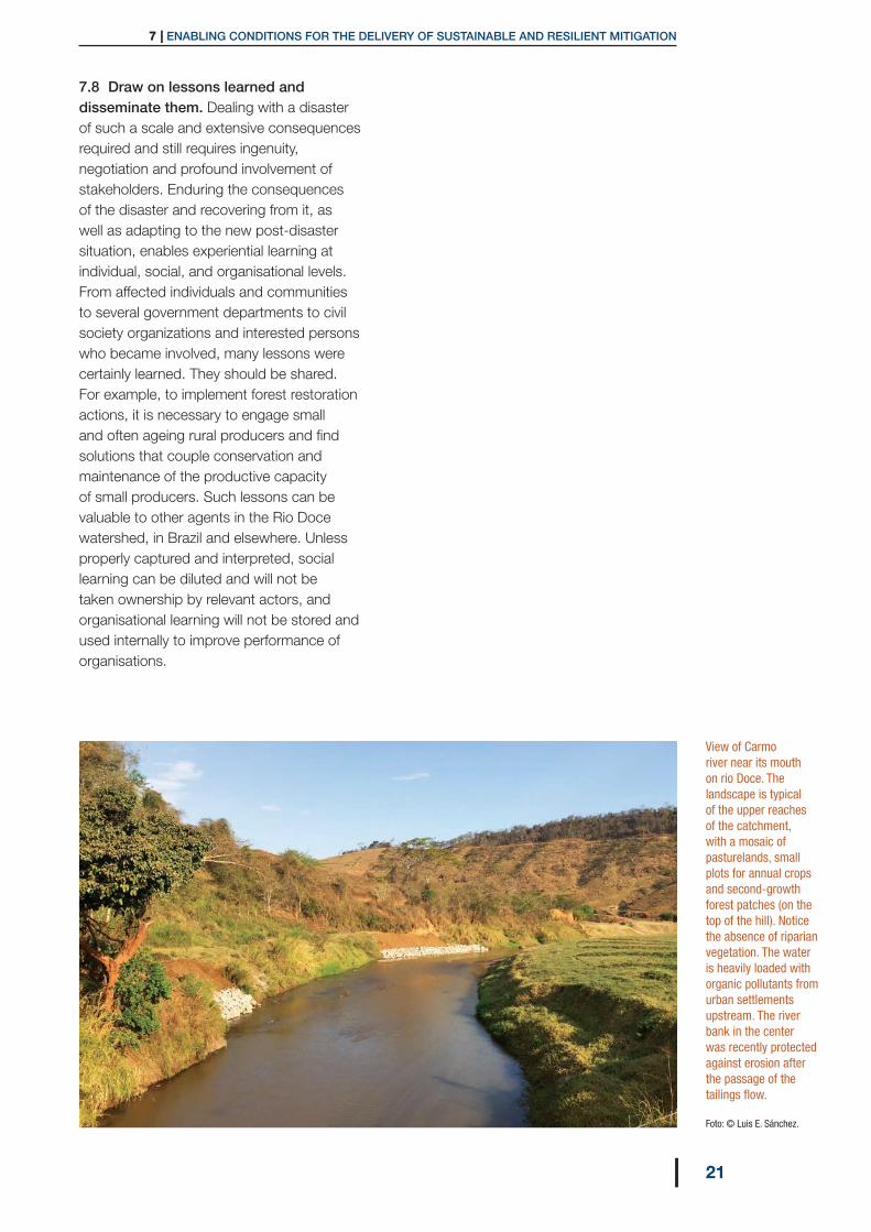
View of Carmo river near its mouth on rio Doce. The landscape is typical of the upper reaches of the catchment, with a mosaic of pasturelands, small plots for annual crops and second-growth forest patches (on the top of the hill). Notice the absence of riparian vegetation. The water is heavily loaded with organic pollutants from urban settlements upstream. The river bank in the center was recently protected against erosion after the passage of the tailings flow. Foto: © Luis E. Sánchez.
Rio Doce Panel Thematic Report No. 1
22 |
8 | Moving forward — seizing opportunities
For all the tragic consequences of the dam failure, it should be recognized that the effort and the resources mobilized for mitigation also opened up a number of opportunities that could be seized to improve environmental quality and human wellbeing in the Rio Doce watershed and the coastal zone. Those opportunities include, but are not limited to the following:
8.1 The response to the disaster required authorities and agencies of all levels of government to work together and to listen to stakeholders. A new governance structure emerged in response to the disaster. Although it inevitably overlaps with existing structures, in particular the River Basin Committee established under the National Water Resources Policy Act, it could be improved and used to foster other cooperation initiatives as well as much needed new approaches. An example of the latter is modernising water governance as proposed by the United Nations’ Water Governance Facility Programme20 to strength water security. An example of potential collaboration is the opportunity for Minas Gerais and Espírito Santo to implement a common system of registering and monitoring the existing land registry CAR (Cadastro Ambiental Rural) and establishing standards for rural properties to implement their
regularization through the PRA (Programa de Regularização Ambiental) that provide additional incentives for compliance with key legislation (Forest Law).21
8.2 The response to the disaster generated a huge amount of data and information: if made available and accessible, this data and information can be used to improve water resources management, land-use planning, other restoration actions, establish priorities for biodiversity conservation and several other applications. As an example, monitoring of the ocean zone encompasses an area 520 km long where more than 48,000 biological, water and sediment samples were collected up to March 2018.
8.3 A joint action of universities in Espírito Santo is being organised to assess the state of the biodiversity in part of the affected area, mostly in the coast and the ocean. To the extent that research objectives can be conciliated with policy needs in a timely manner, this format could be extended to other areas that need further research and could foster a similar initiative with universities and research groups from Minas Gerais. The development of shared research protocols to be used by the different groups of researchers, whenever possible, could help the analysis of the data collected.
20 For further information, please visit: http://watergovernance.org 21 The Rural Environmental Registry System (SICAR), a georeferenced web-based system developed by the Ministry of the Environment and replicated by the states, will enable documentation of over five million rural properties, improve transparency and provide a pathway to environmental compliance. Under the law, states that had already implemented rural environmental licencing systems were permitted to maintain their own CAR registries as long as they were consistent with SICAR, but it would be desirable for consistency that they all adopt the same protocol and mapping tools. The system is operated online and automatically calculates legal liabilities by simply uploading the georeferenced property boundaries and demarcating water bodies and forest patches. This tool is expected to facilitate automated demarcation of potentially tradable areas and will signal land-use changes, thus reducing the costs of monitoring and enforcement. It is expected that SICAR will thus also facilitate the market for quotas of environmental restoration (CRA) a form of tradeable development right authorized under the new Forest Law.

8 | MOVING FORWARD – SEIZING OPPORTUNITIES
23|
8.4 The response to the disaster is contributing to social learning at affected communities and civil society organisations. If such learning can be captured and used or adapted to face other current and future problems, more opportunities for sustainable development at the watershed level would arise.
8.5 The mitigation programmes being implemented by Fundação Renova inject financial and human resources to improve environmental quality in the watershed (e.g. sanitation). These can be used to leverage funds from other sources to help solve historical problems and facilitate the establishment of long-term mechanisms that continuously support restoration efforts and environmental protection.
8.6 The response to the disaster should contribute to organizational learning in leading agencies. An example is Ordinance No. 70389/2017 of the former National Department of Mineral Production (currently National Mining Agency)22 concerning the safety of mining dams, bringing national requirements closer to international recommendations (UNEP, 2001). Another example is the development of ecological risk assessment criteria in support of decisions related to the management of tailings deposited in the river channel, banks and floodplains. Opportunities to improve and strengthen the environmental licensing process can also be identified on the basis of lessons resulting from the involvement of IBAMA and state environmental agencies in the current mitigation effort.
8.7 The processes that enabled mitigation to be initiated generated huge opportunities of building and sharing knowledge on designing, implementing, monitoring and evaluating mitigation programmes. In addition to leaving a positive legacy in terms of increased knowledge about the watershed and the coastal zone, such knowledge can be valuable for tackling similar problems elsewhere.
Fundação Renova could play an important role in effecting the potential of these and other opportunities. Although obviously Fundação Renova cannot act alone and, as a private agent, has a limited mandate, it has a leverage capacity that could be used to transform these opportunities into positive environmental and social outcomes.
22 This Ordinance, under the National Dam Safety Act, substituted previous (2012) ordinances by strengthening requirements of preparedness for emergency action and for warning potentially affected population.
Rio Doce Panel Thematic Report No. 1
24 |
9 | Conclusions and recommendations — A road map
Building on the need and opportunities outlined in the previous sections, this final section presents a number of recommendations for future actions. Although primarily addressed to Fundação Renova in the Rio Doce context, these recommendations might be useful to other stakeholders and could be used as a roadmap potentially applicable to other disaster situations affecting large portions of a watershed. To be implemented, they require partnership and collaboration with several stakeholders.
The recommendations are summarized in Table 1 and briefly described below. Prior to implementing those recommendations, stakeholders should be consulted and detailed guidelines should be prepared for each one.
The recommendations are described briefly in the next pages. A detailed specification or terms of reference should be developed prior to implementing these recommendations, by engaging with relevant stakeholders.
For all the tragic consequences of the dam failure, it should be recognized that the effort and the resources
mobilized for mitigation also opened up a number of opportunities that could be seized to improve environmental quality and human well-being in the Rio Doce watershed and the coastal zone.
“
Rio Doce Panel

9 | CONCLUSIONS AND RECOMMENDATIONS: A ROAD MAP
25|
Table 1 Recommended actions to address sustainability and resilience in mitigation
Consider the cumulative impacts of human activities in a landscape/seascape context
Adopt a multi-scale and multi-temporal approach to guide mitigation
Evaluate the outcomes of mitigation actions in an integrative way
Assess the sustainability and the resilience of mitigation outcomes
Take climate change into account
Consider uncertainties related to mitigation outcomes
Make data and information available and accessible to a wider audience
Draw on lessons learned and disseminate them
Prepare a comprehensive assessment of the impacts of the dam failure considering, for each valued environmental and social component, the baseline at some point in the past prior to the failure as well as trends in the state of those valued components
Carry out an integrated evaluation of outcomes of the mitigation programs
Identify threats to sustainability and resilience of mitigation outcomes and address them
Review regional climate change models and propose improvements in mitigation programmes to address risks to the achievement of outcomes
Develop an adaptive management plan
Develop and implement a data andinformation sharing plan
Initiate and maintain actions to gather and disseminate relevant information and knowledge
PREREQUISITES TO CONSIDER IN THE MITIGATION
RECOMMENDATIONS

Rio Doce Panel Thematic Report No. 1
26 |
Recommendation 1 Prepare a comprehensive assessment of the
impacts of the dam failure considering, for each valued environmental
and social component, the baseline at some point in the past prior to the failure as well
as trends in the state of those valued components
Where knowledge is available, all potentially significant impacts of the dam failure should be identified, their magnitude should be described by appropriate indicators and their significance should be assessed, taking into consideration the state of each environmental and social component prior to the failure and, where appropriate, further back in time. Such an assessment can be prepared on the basis of existing information and knowledge, but gaps, unknowns and uncertainties should be acknowledged. The Panel recommends the preparation of a short, yet comprehensive, objective and adequately illustrated report that should be widely disseminated.
This comprehensive impact assessment should be used to conduct a systematic and thorough review of the 42 programmes which, in turn, and in conjunction with other sources (such as the recommendations of Fundação Renova Consultative Council) could be offered to the Inter-Federative Committee as a basis to update, correct or improve those programmes, as appropriate, under an adaptive management concept (Recommendation #5) and making use, wherever possible, of nature-based solutions.
9 | CONCLUSIONS AND RECOMMENDATIONS: A ROAD MAP
27|
Recommendation 2Carry out an integrated evaluation
of outcomes of the mitigation programs
Due to regulatory requirements, each programme is reported and evaluated separately, despite obvious connections between some of them, e.g. forest restoration, spring protection and resuming agricultural production in affected farms. Beyond mandatory reporting and evaluation, appraising synergies or possible countervailing effects of those programmes is important to improve delivery of outcomes and to enhance the cost-effectiveness of mitigation.
Such integrated evaluation could be carried out through a variety of means, and preferably should take into consideration the perspective of key stakeholders. For example, fishers should be actively involved in the integrated evaluation of programmes directly or indirectly related to fisheries.
The results of the integrated evaluation should feed adaptive management (Recommendation #5) and occasionally suggest the merger, reshaping or better integration of programmes, for consideration by the Inter-Federative Committee.

Rio Doce Panel Thematic Report No. 1
28 |
Recommendation 3Identify threats to sustainability and resilience
of mitigation outcomes and address them
In order to obtain lasting outcomes, it is very important that the threats be adequately understood and appropriate actions be implemented to reduce risks of failure in the long-term. Given the importance of healthy ecosystems to the goal of sustainable and resilient mitigation, due consideration should be given to nature-based solutions. For example, the success of forest restoration can be threatened by a number of factors, such as small farmers not obtaining sufficient income and longer drought periods associated with climate change. Different actions could be considered to enhance sustainability of the forest restoration programme, such as financially compensating small farmers for conserving and maintaining forest stands, possibly by establishing a cap on the number of years such payments could be made. As another example, when the fish ban is terminated, fisheries could be threatened by overfishing, if appropriate controls are not in place. Such controls (e.g. optimal rate of harvest and no-go zones) depend on institutions and regulators, and rarely function if there is no general consensus among the users of the resource with regard to their respective rights and responsibilities.
Different tools could be used for the purpose of identifying and dealing with threats, such as stakeholder analysis and SWOT (strengths-weaknesses-opportunities-threats) analysis. The identification of threats and the review of appropriate actions should be systematically applied to every programme and could result in proposed modifications to be sent for consideration by the Inter-Federative Committee.

9 | CONCLUSIONS AND RECOMMENDATIONS: A ROAD MAP
29|
Recommendation 4Review regional climate change models and propose improvements in mitigation
programmes to address risks to the achievement of outcomes
A study should be developed to apply current understanding of climate change at the regional scale and assess its implications for the sustainability and resilience of the intended outcomes of each programme. The results should be combined with actions issued from Recommendation #3 and eventually be conveyed to the Inter-Federative Committee as proposals to revise and update the mitigation programmes.
Despite limitations of current knowledge related to regional scale climate change modelling, this review is urgently necessary to improve the cost-effectiveness of a number of mitigation programmes. Possible changes in rainfall patterns are but an example of foreseeable changes whose consequences on the sustainability of mitigation require to be better assessed. The analysis might consider the cost-effectiveness of integrating emissions mitigation (associated with restoration investments) with efforts to prepare for regional climate risks (adaptation).
Rio Doce Panel Thematic Report No. 1
30 |
Recommendation 5Develop an adaptive management plan
An adaptive management plan should systematically identify risks for each programme, i.e. risks of a programme not reaching its goal and delivering its intended outcomes. Such a plan should set out requirements or recommendations for periodic performance review and corrective action, as needed. It is important that nature-based solutions be considered as actions, when appropriate. However, a warning is needed in relation to the fact that there is not much flexibility in the implementation of the 42 programmes defined from the outset. Every action needs the approval of the competent authority and other agencies participating in one or more technical chambers of the Inter-Federative Committee.
A risk analysis could be the basis to prepare the adaptive management plan. Proposed amendments to the programmes need to be substantiated and grounded on the conclusions of Recommendations #1 to #4. In re-designing, amending or updating mitigation plans, preference should be given to nature-based solutions.

9 | CONCLUSIONS AND RECOMMENDATIONS: A ROAD MAP
31|
Recommendation 6Develop and implement a data and
information-sharing plan
Several studies on different aspects of the Rio Doce and the coastal zone have been conducted or are underway, either funded by Fundação
Renova to respond to requests from the Inter-Federative Committee or independently initiated by researchers. Furthermore, monitoring of water quality, water flows, marine water, sediments and biota, and several other variables increased substantially after the disaster.
The plan should be developed in consultation with relevant stakeholders (e.g. universities, government agencies, non-governmental organisations) and consider types of data to be made available, data quality, repositories, access, responsibilities for maintenance, long-term custodianship and other pertinent characteristics.

Rio Doce Panel Thematic Report No. 1
32 |
Recommendation 7Initiate and maintain actions to
gather and disseminate relevant knowledge and lessons learned
Lessons learned in the Rio Doce recovery effort can be valuable for two reasons: (i) to enhance the outcomes of the mitigation programmes; and (ii) to inform and inspire other environmental restoration actions elsewhere, matching scientific and customary knowledge. If not properly harnessed, a significant part of social and organizational learning can be lost. This calls for initiatives to capture, register and disseminate lessons learned.
Actions for that purpose include an array of options, such as organising meetings/seminars/focal groups and using other formats to capture lessons learned under different perspectives, e.g. public policies, regulation, social learning. In a similar way, different approaches and tools can be used to disseminate lessons learned. This recommendation includes evaluating whether the lessons learned under the Inter-Federative Committee governance model could be valuable if the Rio Doce experience is to be replicated or adapted in other places.

EPILOGUE
33|
Epilogue
The challenges of repairing the damages resulting from the Fundão Dam failure in a timely, fair and lasting way are manifold. The Panel acknowledges the invaluable efforts of many organizations and individuals to increase the understanding and knowledge about the impacts, in designing and implementing the remediation, restoration and compensation programmes, and in evaluating progress of effecting those programmes and their outcomes. The Panel’s vision of a long term environmental and socio-economic health and resilience for the Rio Doce Basin and adjoining coastal zone is achievable by a combination of those efforts with other initiatives.
The recommendations contained in this first Thematic Paper are primarily directed to Fundação Renova. However, addressing pre-existing impacts accumulated over time and space in the Rio Doce River Basin and the coastal zone requires more than successfully mitigating the impacts of the dam failure: actions by governments, citizens’ groups and private organisations are urgently necessary to address the widely-recognized problems – such as sewage treatment and afforestation – as well as foreseeable challenges. Furthermore, once mitigation of the impacts of the dam failure is satisfactorily delivered, their positive outcomes need to be maintained and enhanced well beyond the mandate and possibly, the existence of Fundação Renova.

Rio Doce Panel Thematic Report No. 1
34 |
Albino, J., Girardi, G. and Nascimento, K.A. (2006). ‘Erosão e progradação do litoral brasileiro - Espírito Santo’ (Erosion and progradation in the Brazilian coastal zone – Espírito Santo). In: D. Muehe (ed.) Erosão e progradação no litoral brasileiro, pp. 227-264. Brasília: Ministério do Meio Ambiente. Available at: http://www.mma.gov.br/estruturas/sqa_sigercom/_publicacao/78_publicacao12122008090123.pdf
ANA (Agência Nacional de Águas). (2013). Plano Integrado de Recursos Hídricos da Bacia Hidrográfica do Rio Doce, Relatório Executivo (Integrated water resources plan of the Rio Doce watershed: Executive summary). Brasília: ANA. Available at: http://www3.ana.gov.br/portal/ANA/sala-de-situacao/rio-doce/documentos-relacionados/encarte-qualidade-da-gua-do-rio-doce-dois-anos-apos-rompimento-de-barragem-de-fundao-1.pdf
ANA (Agência Nacional de Águas). (2015). Encarte Especial sobre a Bacia do Rio Doce – Rompimento da Barragem em Mariana/MG (Special insert on the Rio Doce watershed – Failure of the dam in Mariana/Minas Gerais). Brasília: ANA. Available at: http://www3.ana.gov.br/portal/ANA/sala-de-situacao/rio-doce/documentos-relacionados/encarte-qualidade-da-gua-do-rio-doce-dois-anos-apos-rompimento-de-barragem-de-fundao-1.pdf
Broderick, M., Durning, B., Sánchez, L.E. (2018). ‘Cumulative effects’. In: Therivel, R., Wood, G. (eds). Methods of Environmental and Social Impact Assessment, 4th edn. Routledge, New York, pp 649-677.
Carmo, F.F.D., Kamino, L.H.Y., Junior, R.T., Campos, I.C.D., Silvino, G., Castro, K.J.D.S.X.D., Mauro, M.L., Rodrigues, N.U.A., Miranda, M.P.D.S., Pinto, C.E.F. (2017). ‘Fundão tailings dam failure: the environment tragedy of the largest technological disaster of Brazilian mining in global context’. Perspectives in Ecology and Conservation 15 (3): 145-151. Available at: https://doi.org/10.1016/j.pecon.2017.06.002
Carpenter, S., Walker, B., Anderies, J.M. and Abel, N. (2001). ‘From metaphor to measurement: resilience of what to what?’. Ecosystems 4: 765-781. Available at: https://doi.org/10.1007/s10021-001-0045-9 CCME (Canadian Council of Ministers of the Environment). (2014). Canada-wide definitions and principles for cumulative effects. Winnipeg: CCME. Available at: https://www.ccme.ca/files/Resources/enviro_assessment/CE%20Definitions%20and%20Principles%201.0%20EN.pdf
Coelho, A.L.C. (2006). ‘Situação hídrico-geomorfológica da bacia do Rio Doce com base na série histórica de vazões da estação de Colatina-ES’ (Geomorpholgical situation of the Doce River based on the data of the historical series of debit of the hydrometeorological station of Colatina in Espírito Santo State – Brazil). Caminhos da Geografia 6: 56-79. Available at: www.seer.ufu.br/index.php/caminhosdegeografia/article/download/15489/8768
References

REFERENCES
35|
Cohen-Shacham, E., Walters, G., Jansen, C. and Maginnis, S. (eds.) (2016). Nature-based solutions to address global societal challenges. Gland, Switzerland: IUCN, xiii + 97 pp. Available at: http://dx.doi.org/10.2305/IUCN.CH.2016.13.en
Consórcio Ecoplan/Lume (2010). Plano Integrado de Recursos Hídricos da Bacia do Rio Doce: Volume 1, Relatório Final. (Integrated water resources plan of the Rio Doce watershed: Volume 1, Final Report). Available at: http://www.cbhdoce.org.br/wp-content/uploads/2014/10/PIRH_Doce_Volume_I.pdf
Econservation. (2017). Análise Integrada dos Contornos do Deslocamento das Plumas de Turbidez no Meio Marinho (Integrated analysis of turbidity plumes limits in the marine environment). Relatório Técnico – RT ECV 233/16, Revision 01, February 2017.
Fernandes, G.W., Goulart, F.F., Ranieri, B.D., Coelho, M.S., Dales, K., Boesche, N., Bustamante, M., Carvalho, F.A., Carvalho, D.C., Dirzo, R., Fernandes, S., Galetti, P.M., Millan, V.E.G., Mielke, C., Ramirez, J.L., Neves, A., Rogass, C., Ribeiro, S.P., Scariot, A., Soares-Filho, B. (2016). ‘Deep into the mud: ecological and socio-economic impacts of the dam breach in Mariana, Brazil’. Natureza & Conservacão 14 (2): 35-45.
Fragoso-Moura, E.N., Oporto, L.T., Maia-Barbosa, P.M. and Babosa, F.A.R. (2016). ‘Loss of biodiversity in a conservation unit of the Brazilian Atlantic Forest: the effect of introducing non-native fish’. Brazilian Journal of Biology 76(1):18-27. Available at: http://dx.doi.org/10.1590/1519-6984.07914
Folke, C. (2016). ‘Resilience’. In: Oxford Research Encyclopedia of Environmental Science [on-line]. http://environmentalscience.oxfordre.com/view/10.1093/acrefore/9780199389414.001.0001/acrefore-9780199389414-e-8
Gomes, L.E.O., Correa, L.B., Sá, F., Rodrigues Neto, R., Bernardino, A.F. (2017). The impacts of the Samarco mine tailing spill on the Rio Doce estuary, Eastern Brazil. Marine Pollution Bulletin 120: 28-36. Available at: https://www.sciencedirect.com/science/article/pii/S0025326X17303636
Granit, J., Liss-Lymen, B., Olsen, S., Tengberg, A., Nõmmann, S. and Clausen, T.J. (2017). ‘A conceptual framework for governing and managing key flows in a source-to-sea continuum’. Water Policies 19: 673-691. Available at: http://wp.iwaponline.com/content/ppiwawaterpol/19/4/673.full.pdf
Guerra, A., Pochmann, M. and Silva, R.A. (2014). Atlas da Exclusão Social no Brasil (Atlas of social exclusion in Brazil). São Paulo: Cortez.

Rio Doce Panel Thematic Report No. 1
36 |
Hatje, V.; Pedreira, R.M.E., Rezende, C.E., Schettini, C.A.F., Souza, G.C., Marin, D.C., Hackspacher, P.C. (2017). ‘The environmental impacts of one of the largest tailing dam failures worldwide’. Scientific Reports 7: 10706. Available at: https://www.nature.com/articles/s41598-017-11143-x
IAIA (International Association for Impact Assessment). (2013). Mitigation in impact assessment. FasTips No. 6. Fargo: IAIA. Available at: http://www.iaia.org/uploads/pdf/Fastips_6Mitigation.pdf
IBAMA (Instituto Brasileiro do Meio Ambiente e dos Recursos Naturais Renováveis). (2015). Laudo Técnico Preliminar. Impactos ambientais decorrentes do desastre envolvendo o rompimento da barragem de Fundão, em Mariana, Minas Gerais (Preliminary technical report. Environmental impacts resulting from the disaster envolving the failure of Fundão Dam in Mariana. Minas Gerais). Available at http://www.ibama.gov.br/phocadownload/barragemdefundao/laudos/laudo_tecnico_preliminar_Ibama.pdf
IBAMA (Instituto Brasileiro do Meio Ambiente e dos Recursos Naturais Renováveis). (2017). Plumas de Sedimentos na Foz do Rio Doce – Consolidação dos Mapas Gerados de 03/12/2015 a 03/02/2017 (Sediment plumes in the mouth of Rio Doce – Consolidation of maps from 3 December 2015 to 3 February 2017). Available at http://ibama.gov.br/recuperacao-ambiental/rompimento-da-barragem-de-fundao-desastre-da-samarco/documentos-relacionados-ao-desastre-da-samarco-em-mariana-mg
ICMBio (Instituto Chico Mendes de Conservação da Biodiversidade). (2017a). Monitoramento da Pluma de Sedimentos Proveniente da Barragem de Fundão (Monitoring of the sediment plume from Fundão Dam). Nota Técnica nº 23/2017/ VitoriaES/TAMAR/DIBIO/ICMBio; Vitória: ICMBio. Available at: http://www.icmbio.gov.br/portal/images/stories/Rio_Doce/nota_tecnica_23_2017_Tamar_ICMBio_monitoramento_pluma.pdf
ICMBio (Instituto Chico Mendes de Conservação da Biodiversidade). (2017b). Identificação da área atingida pela pluma de rejeitos da Samarco e das principais comunidades pesqueiras existentes na mesma (Identification of the area affected by Samarco’s tailings plume and the main fishing communities). Nota Técnica nº 3/2017/ VitoriaES/TAMAR/DIBIO/ICMBio; Vitória: ICMBio. Available at http://www.icmbio.gov.br/portal/images/stories/Rio_Doce/NT_CTAMAR_03_2017.pdf
ICMM (International Council of Mining and Metals). (2016). Review of tailings management guidelines and recommendations for improvement. Prepared by Golder Associates Africa (Pty) Ltd., Midrand, South Africa. Available at: https://www.icmm.com/website/publications/pdfs/tailings/161205_review-of-tailings-management-guidelines.pdf

REFERENCES
37|
IEMA (Instituto Estadual de Meio Ambiente e Recursos Hídricos). (2016). Alterações na Metodologia de Monitoramento da Dispersão dos Rejeitos de Mineração na Zona Marinha do Espírito Santo, Sudoeste do Atlântico (Changes in the methodology of monitoring mine tailings dispersal in the Espírito Santo marine zone, Southeast Atlantic). Nota Técnica DT/Monitoramento Marinho no. 013/2016.
IFC (International Finance Corporation). (2013). Good Practice Handbook: Cumulative Impact Assessment and Management, Guidance for the Private Sector in Emerging Markets. Washington, DC: IFC. Available at: https://www.ifc.org/wps/wcm/connect/topics_ext_content/ifc_external_corporate_site/sustainability-at-ifc/publications/publications_handbook_cumulativeimpactassessment
Lima, J.E.F.W., Lopes, W.T.A., Carvalho, N.O., Vieira, M.R., Silva, E.M. (2005). Suspended sediment fluxes in the large river basins of Brazil. Sediment Budgets 1 (Proceedings of symposium S1 held during the Seventh IAHS Scientific Assembly at Foz do Iguaçu, Brazil, April 2005). IAHS Publ. 291. Available at: https://iahs.info/uploads/dms/13042.48%20355-363%20S11-19%20Werneck%20et%20al.pdf
Maia-Barbosa, P.M., Barbosa, L.G., Brito, S.L., Garcia, F.C., Barros, C.F.A., Souza, M.B.G.;Mello, N.A.S.T., Guimarães, A. de S.; Barbosa, F.A.R. (2010). ‘Limnological changes in Dom Helvécio Lake (South-East Brazil): natural and anthropogenic causes’. Brazilian Journal of Biology 70: 795-802. Available at: http://www.scielo.br/scielo.php?script=sci_arttext&pid=S1519-69842010000400010
Neri, A.C., Dupin, P., Sánchez, L.E. (2016). ‘A pressure-state-response approach to cumulative impact assessment’. Journal of Cleaner Production 126: 288-298. Available at: https://www.sciencedirect.com/journal/journal-of-cleaner-production/vol/126
Ottoni, F.P., Lezama, A.Q., Triques, M.L.; Fragoso-Moura, E.N., Lucas, C.C.T., Barbosa, F.A.R. (2011). ‘Australoheros perdi, new species (Teleostei: Labroidei: Cichlidae) from the lacustrine region of the Doce River Valley, southeastern Brazil, with biological information’. Vertebrate Zoology 61: 137-145. Available at http://www.periodicoseletronicos.ufma.br/index.php/blabohidro/index
Philips, B.D. (2016). Disaster Recovery. Boca Raton: CRC Press, 2nd edition.
Quaresma, V.S., Catabriga, G.; Bourguignon, S.N.; Godinho, E., Bastos, A.C. (2015). ‘Modern sedimentary processes along the Doce River adjacent continental shelf’. Brazilian Journal of Geology 45(3): 635-644. Available at http://www.scielo.br/scielo.php?script=sci_arttext&pid=S2317-48892015000500635

Rio Doce Panel Thematic Report No. 1
38 |
Queiroz, H.M., Nóbrega, G.N., Ferreira, T.O., Almeida, L.S., Romero, T.B., Santaella, S.T., Bernardino, A.F., Otero, X.L. (2018); The Samarco mine tailing disaster: A possible time-bomb for heavy metals contamination. Science of the Total Environment 637-638: 498-506. Available at https://www.sciencedirect.com/science/article/pii/S0048969718315547
Roche, C., Thygesen, K. and Baker, E. (eds.) (2017). Mine Tailings Storage: Safety Is No Accident. A UNEP Rapid Response Assessment. Nairobi and Arendal: United Nations Environment Programme and GRID-Arendal. Available at: https://gridarendal-website-live.s3.amazonaws.com/production/documents/:s_document/371/original/RRA_MineTailings_lores.pdf?1510660693
Rudorff, N., Rudorff, C.M., Kampel, M. and Ortiz, G. (2018). ‘Remote sensing monitoring of the impact of a major mining wastewater disaster on the turbidity of the Doce River plume off the eastern Brazilian coast’. ISPRS Journal of Photogrammetry and Remote Sensing. Available at: https://www.sciencedirect.com/science/article/pii/S0924271618300480
Tuncak, B. (2017). ‘Lessons from the Samarco disaster’. Business and Human Rights Journal 2: 157-162. Available at: Available at https://www.cambridge.org/core/journals/business-and-human-rights-journal/article/div-classtitlelessons-from-the-samarco-disasterspan-classsup1spandiv/5502598996B9E9CAC9439380A61A8848#
UNEP (United Nations Environment Programme). (2001). APELL for Mining. Guidance for the Mining Industry in Raising Awareness and Preparedness for Emergencies at Local Level. Paris: UNEP. Available at: http://www.unep.fr/shared/publications/pdf/webx0055xpa-apellminingen.pdf
UNGA (United Nations General Assembly). (2016). Report of the open-ended intergovernmental expert working group on indicators and terminology relating to disaster risk reduction. A/71/644. New York: United Nations. Available at: https://reliefweb.int/sites/reliefweb.int/files/resources/50683_oiewgreportenglish.pdf
Vieira, F. (2009). ‘Distribuição, impactos ambientais e conservação da fauna de peixes da bacia do rio Doce’ (Distribution, environmental impacts and conservation of fish fauna in the Rio Doce watershed). MG. Biota 2 (5): 5-22. Available at: http://ief.mg.gov.br/images/stories/MGBIOTA/mgbiota11/mgbiot_%20v.2n.5.pdf #page=5
Walker, J. and Cooper, M. (2011). ‘Genealogies of resilience: from systems ecology to the political economy of crisis adaptation’. Security Dialogue 42(2): 143-160. Available at: https://www.researchgate.net/profile/Jeremy_Walker6/publication/258186723_Genealogies_of_Resilience_From_Systems_Ecology_to_the_Political_Economy_of_Crisis_Adaptation/links/562f509908aea5dba8d34354/Genealogies-of-Resilience-From-Systems-Ecology-to-the-Political-Economy-of-Crisis-Adaptation.pdf


INTERNATIONAL UNIONFOR CONSERVATION OF NATURE
WORLD HEADQUARTERSRue Mauverney 281196 Gland, [email protected]
Tel +41 22 999 0000Fax +41 22 999 0002www.iucn.org