Impacts of soil and groundwater salinization on tree crop ...
13
Nat. Hazards Earth Syst. Sci., 12, 2879–2891, 2012 www.nat-hazards-earth-syst-sci.net/12/2879/2012/ doi:10.5194/nhess-12-2879-2012 © Author(s) 2012. CC Attribution 3.0 License. Natural Hazards and Earth System Sciences Impacts of soil and groundwater salinization on tree crop performance in post-tsunami Aceh Barat, Indonesia C. Marohn 1 , A. Distel 1 , G. Dercon 1,* , Wahyunto 2 , R. Tomlinson 3 , M. v. Noordwijk 4 , and G. Cadisch 1 1 Institute of Plant Production and Agroecology in the Tropics and Subtropics, University of Hohenheim, 70593 Stuttgart, Germany 2 Indonesian Soil Research Institute, Jl. Juanda 98, Bogor 16123, Indonesia 3 Catholic Relief Services, 228 W. Lexington St., Baltimore, Maryland, USA 4 World Agroforestry Centre, Jl. CIFOR, Sindang Barang, Bogor, Indonesia * current address: Joint FAO/IAEA Division of Nuclear Techniques in Food and Agriculture, International Atomic Energy Agency – IAEA, Wagramerstrasse 5, 1400, Vienna, Austria Correspondence to: C. Marohn ([email protected]) Received: 21 March 2012 – Revised: 1 August 2012 – Accepted: 5 August 2012 – Published: 12 September 2012 Abstract. The Indian Ocean tsunami of December 2004 had far reaching consequences for agriculture in Aceh province, Indonesia, and particularly in Aceh Barat district, 150 km from the seaquake epicentre. In this study, the spatial distri- bution and temporal dynamics of soil and groundwater salin- ity and their impact on tree crops were monitored in Aceh Barat from 2006 to 2008. On 48 sampling points along ten transects, covering 40 km of coastline, soil and groundwa- ter salinity were measured and related to mortality and yield depression of the locally most important tree crops. Given a yearly rainfall of over 3000 mm, initial groundwater salin- ity declined rapidly from over 10 to less than 2 mS cm -1 within two years. On the other hand, seasonal dynamics of the groundwater table in combination with intrusion of saline water into the groundwater body led to recurring elevated salinity, sufficient to affect crops. Tree mortality and yield depression in the flooded area varied considerably between tree species. Damage to coconut (65 % trees damaged) was related to tsunami run-up height, while rubber (50 % trees damaged) was mainly affected by groundwater salinity. Co- conut yields (-35 % in average) were constrained by ground- water Ca 2+ and Mg 2+ , while rubber yields (-65 % on av- erage) were related to groundwater chloride, pH and soil sodium. These findings have implications on planting deep- rooted tree crops as growth will be constrained by ongoing oscillations of the groundwater table and salinity. 1 Introduction and scope On 26 December 2004, a seaquake with magnitude of 9.3 on the Richter scale close to the North Sumatran coast caused one of the most devastating tsunamis in recorded history. Worldwide, documented losses of human lives due to the disaster exceeded 250 000 and more than 1 million people were displaced (Szczuci´ nski et al., 2006). The province of Nanggroe Aceh Darussalam, and especially its district Aceh Barat, only 150 km from the epicentre, was most severely affected by the consequences of the seismic shock and the subsequent tsunami. Entire villages around the district capi- tal Meulaboh were destroyed, and Shofiyati et al. (2005) re- ported that, out of 120 295 ha flooded land in Aceh province, almost 19 000 ha were situated in the district of Aceh Barat. Analysis of satellite imagery showed that more than 17 % of over 200 000 ha agricultural land surveyed in Aceh and al- most 25 % in Aceh Barat were affected by flooding due to the tsunami. While research on the role of vegetation to protect peoples’ lives and property has been conducted in the area (Laso Bayas et al., 2011), information on tsunami impacts on agriculture is scarce. Agriculture had been one of the most important sectors contributing to provincial employment and GDP before the tsunami (48 % and 32 %, respectively; CGI, 2005). The ma- jor crops grown by small-holders along the Acehnese west coast were paddy rice, vegetables, rubber, coconut, cocoa, fruit trees and, to a minor extent, oil palm (CGI, 2005). Tree Published by Copernicus Publications on behalf of the European Geosciences Union.
Transcript of Impacts of soil and groundwater salinization on tree crop ...

Nat. Hazards Earth Syst. Sci., 12, 2879–2891, 2012www.nat-hazards-earth-syst-sci.net/12/2879/2012/doi:10.5194/nhess-12-2879-2012© Author(s) 2012. CC Attribution 3.0 License.
Natural Hazardsand Earth
System Sciences
Impacts of soil and groundwater salinization on tree cropperformance in post-tsunami Aceh Barat, Indonesia
C. Marohn1, A. Distel1, G. Dercon1,*, Wahyunto2, R. Tomlinson3, M. v. Noordwijk 4, and G. Cadisch1
1Institute of Plant Production and Agroecology in the Tropics and Subtropics, University of Hohenheim,70593 Stuttgart, Germany2Indonesian Soil Research Institute, Jl. Juanda 98, Bogor 16123, Indonesia3Catholic Relief Services, 228 W. Lexington St., Baltimore, Maryland, USA4World Agroforestry Centre, Jl. CIFOR, Sindang Barang, Bogor, Indonesia* current address: Joint FAO/IAEA Division of Nuclear Techniques in Food and Agriculture,International Atomic Energy Agency – IAEA, Wagramerstrasse 5, 1400, Vienna, Austria
Correspondence to:C. Marohn ([email protected])
Received: 21 March 2012 – Revised: 1 August 2012 – Accepted: 5 August 2012 – Published: 12 September 2012
Abstract. The Indian Ocean tsunami of December 2004 hadfar reaching consequences for agriculture in Aceh province,Indonesia, and particularly in Aceh Barat district, 150 kmfrom the seaquake epicentre. In this study, the spatial distri-bution and temporal dynamics of soil and groundwater salin-ity and their impact on tree crops were monitored in AcehBarat from 2006 to 2008. On 48 sampling points along tentransects, covering 40 km of coastline, soil and groundwa-ter salinity were measured and related to mortality and yielddepression of the locally most important tree crops. Given ayearly rainfall of over 3000 mm, initial groundwater salin-ity declined rapidly from over 10 to less than 2 mS cm−1
within two years. On the other hand, seasonal dynamics ofthe groundwater table in combination with intrusion of salinewater into the groundwater body led to recurring elevatedsalinity, sufficient to affect crops. Tree mortality and yielddepression in the flooded area varied considerably betweentree species. Damage to coconut (65 % trees damaged) wasrelated to tsunami run-up height, while rubber (50 % treesdamaged) was mainly affected by groundwater salinity. Co-conut yields (−35 % in average) were constrained by ground-water Ca2+ and Mg2+, while rubber yields (−65 % on av-erage) were related to groundwater chloride, pH and soilsodium. These findings have implications on planting deep-rooted tree crops as growth will be constrained by ongoingoscillations of the groundwater table and salinity.
1 Introduction and scope
On 26 December 2004, a seaquake with magnitude of 9.3 onthe Richter scale close to the North Sumatran coast causedone of the most devastating tsunamis in recorded history.Worldwide, documented losses of human lives due to thedisaster exceeded 250 000 and more than 1 million peoplewere displaced (Szczucinski et al., 2006). The province ofNanggroe Aceh Darussalam, and especially its district AcehBarat, only 150 km from the epicentre, was most severelyaffected by the consequences of the seismic shock and thesubsequent tsunami. Entire villages around the district capi-tal Meulaboh were destroyed, and Shofiyati et al. (2005) re-ported that, out of 120 295 ha flooded land in Aceh province,almost 19 000 ha were situated in the district of Aceh Barat.Analysis of satellite imagery showed that more than 17 %of over 200 000 ha agricultural land surveyed in Aceh and al-most 25 % in Aceh Barat were affected by flooding due to thetsunami. While research on the role of vegetation to protectpeoples’ lives and property has been conducted in the area(Laso Bayas et al., 2011), information on tsunami impactson agriculture is scarce.
Agriculture had been one of the most important sectorscontributing to provincial employment and GDP before thetsunami (48 % and 32 %, respectively; CGI, 2005). The ma-jor crops grown by small-holders along the Acehnese westcoast were paddy rice, vegetables, rubber, coconut, cocoa,fruit trees and, to a minor extent, oil palm (CGI, 2005). Tree
Published by Copernicus Publications on behalf of the European Geosciences Union.

2880 C. Marohn et al.: Impacts of soil and groundwater salinization on tree crop performance
Fig. 1. (left) Subsided land 200 m from the sea in Suak Nie, near Meulaboh, Aceh Barat, Indonesia, as consequence of the earthquake, and(right) tsunami mud deposits, 100 m from the seashore.
crops, including natural vegetation such asNypa fruticans,contributed 15 to 45 % to the local pre-tsunami economy inthe four coastal subdistricts of Aceh Barat (Joshi et al., 2007).
First projections after the disaster, usually based on remotesensing data and on electric conductivity (EC) measurementsin shallow wells for drinking water, predicted dismal per-spectives for agriculture in the province. Mid- to long-termreduction in crop productivity was expected even in mod-erately affected districts (CGI, 2005), and large areas weredeemed to be permanently lost for agricultural use (Verrelstand Schaepman, 2007). Two main mechanisms were sup-posed to affect plants: (a) fast salinization caused by seawa-ter inundation at the time of the tsunami and (b) exposure ofroots to salts contained in tsunami deposits, by ingrowth orleaching, over a longer period. Additionally, for parts of thearea, changed groundwater regime due to subsidence of landwas expected to cause problems.
Mud-related problems in Aceh Barat arose mainly in pad-dies, where rice roots did not reach the water-logged horizonscovered under thick sediments. In other parts of Aceh, highconcentrations of Mg2+ were found in fresh tsunami sedi-ments (Chaerun et al., 2008). Agus et al. (2008) and Rach-man (2008) identified unbalanced ratios of Na+, Ca2+ andMg2+ ions as a cause for empty pods in peanut and limitedgrain filling in rice. However, in some cases, plants actuallybenefited from tsunami mud. For example, farmers coinedthe term tsunami fertilizer, due to higher yields of vegetablesobtained at mud-covered sites. For Sri Lanka, Chaudary etal. (2006) described improvements of soil texture, C, N andP due to tsunami mud.
For Aceh Barat, few data on soil and groundwater con-tamination existed as most post-tsunami research focused onBanda Aceh and Aceh Besar districts, more than 270 kmnorthwest along the coast from the study area described inthis paper. Despite the economic importance of tree crops,
tsunami-related research was almost exclusively conductedon annual crops like paddy rice and vegetables (Agus etal., 2008). In contrast, trees are characterized by deep root-ing systems, which make them more susceptible to soiland groundwater salinity, even though many trees disposeof detoxification by mechanisms like leaf shedding. It wasassumed that tree growth was equally influenced by bothgroundwater and mud salinity (FAO, 2005; McLeod et al.,2010), whereas annuals were more affected by mud. Initially,farmers’ reports on tree mortality and crop failure seemedto confirm these concerns. Although tree crop damage waswidely evident in the landscape, underlying causes were notclear. For reconstruction of the agricultural sector in AcehBarat it is, however, indispensable to understand the mecha-nisms causing tree crop damage and yield depression and tobe able to predict their permanence in the mid- to long-termperspective.
Visual distinction of salinity-based factors leading to treecrop damage was mostly not possible. It was expected soonafter the disaster that cation imbalances and, to minor extent,water stress would be the most serious mid-term constraintsto plant production (Subiksa and Agus, 2008), followed byeffects owed to a permanently changed groundwater table.Especially the long-term impact of ions, such as chloride(Cl−), sodium (Na+), and sulphate (SO42−), gradually re-leased from the tsunami mud, was expected to affect plantgrowth.
Post-tsunami studies carried out in Sri Lanka, India andAceh Besar led to the hypothesis of the following major rea-sons for (tree) crop damage: (i) extreme mechanical forcesof the tsunami resulting into breakage and uprooting of trees,mainly within the first kilometer from the coastline; (ii) sub-sidence caused by the earthquake, which irreversibly led toloss of land area to the sea, connection of freshwater bod-ies to the sea and permanent flooding in depressions further
Nat. Hazards Earth Syst. Sci., 12, 2879–2891, 2012 www.nat-hazards-earth-syst-sci.net/12/2879/2012/

C. Marohn et al.: Impacts of soil and groundwater salinization on tree crop performance 2881
Fig. 2. (left) Digital elevation model extracted from Siemon et al. (2007) for the study area around Meulaboh during the tsunami event inAceh, the westernmost province on the Indonesia map. Dots indicate the points sampled during this study; (right) ridges and swales parallelto the coast line about 15 km SE of Meulaboh.
inland (Fig. 1a); (iii) inundation of the flat coastal landscapeup to 5 km inland (Fig. 1b) and, depending upon residencetime (Szczucinski et al., 2006), subsequent infiltration ofsaline water into the soil and groundwater (Villholth et al.,2005); and (iv) a deposition of saline tsunami mud of upto 1 m thickness, which buried plants or transformed paddyfields into free-draining soils (Fig. 1b).
This study aims at integrating spatial-temporal dynamicsof salinization to tree crop damage as well as to specificgrowth-limiting factors, in order to understand mechanismsrelevant to replanting of tree crop-based systems in coastalareas affected by tsunamis in the future. The specific objec-tives of the study were (i) to characterize spatial variability ofsalinization in groundwater and soils following the tsunamievent of 2004; (ii) to assess seasonal variability of salinity-related groundwater parameters; (iii) to relate mud cover aswell as chemical properties of groundwater and soils to dam-age and yield depression of tree crops observed in the field;and (iv) to distinguish effects of the different limiting factorsand deducting recommendations for tree crop rehabilitationin the aftermath of a tsunami event in tropical regions.
2 Materials and methods
2.1 Study site description
Research was carried out in the framework of the Re-GrIn1 project along a coastal strip of 40 km around thetown of Meulaboh, district capital of Aceh Barat, in North-ern Sumatra (between 04◦19′19.4′′ N, 95◦56′14.9′′ E and04.◦05′14.1′′ N, 96◦12′57.1′′ E). The coastline is relativelystraight northwest – southeast oriented with two prominenttips shaped through estuaries (Fig. 2a). The area is subdi-vided by southwest oriented rivers that discharge into theIndian Ocean. Tsunami flooding extended up to 5 km landinward. Within the flooded area, apart from small dunes onthe beach, topography is predominantly flat with a maximumelevation of approximately 5 m a.s.l., but characterized by se-quences of narrow, shore-parallel ridges and swales (Fig. 2b).
Most coastal soils in Aceh Barat developed on recent ma-rine and fluviatile alluvium (Siemon et al., 2007) and areclassified as dystric Arenosols and dystric or thionic Gleysols
1 Rebuilding Green Infrastructure with Trees People Want,funded by the EU Eco ASIA IIb programme.
www.nat-hazards-earth-syst-sci.net/12/2879/2012/ Nat. Hazards Earth Syst. Sci., 12, 2879–2891, 2012

2882 C. Marohn et al.: Impacts of soil and groundwater salinization on tree crop performance
according to the World Reference Base of Soil Resources(FAO, ISRIC and ISSS, 2006). In general, both soil typesare characterized by low macronutrient contents, moderatelyacidic to slightly alkaline pH and sandy texture; the main cri-terion for distinction is groundwater depth. The bottom ofthe river valleys in the study area is characterized by morefertile Fluvisols (Wahyunto et al., 2009). Land inward acidicand organic soils, i.e. dystric Histosols (peat domes), can befound.
Before the 2004 tsunami event, land use on the marinesoils was dominated by vegetables and fruit trees in the well-drained areas and paddy, fish ponds,Nypa fruticans, natu-ral swamp vegetation in the water-logged parts, whereas co-conut was grown across all (except water-logged) agroeco-logical zones. Peat lands were predominantly under exten-sive “jungle rubber” but have been increasingly convertedinto oil palm plantations, vegetable and rice plots since 2005.Alluvial soils along the rivers were used for paddy rice culti-vation.
The coastal part of the district is characterized by a humidtropical climate with bimodal rainfall pattern. During the pe-riod relevant for this study (2004 to 2007), average annualrainfall amounted to more than 3600 mm with a drier intervalbetween May and mid-September (Badan Meteorologi danGeofisika, Meulaboh, 2008), which is characterized by rela-tively lower precipitation of less than 300 mm month−1 andclearly deeper groundwater table. In May 2007, a floodingevent not related to seasonal weather phenomena hit AcehBarat. The flood was referred to as the most severe since thetsunami and inundated parts of the study area up to 500 minland. Seawater resided for several days, affecting soils anddestroying agricultural crops once again.
2.2 Soil and groundwater sampling strategy
Water quality in shallow drinking water wells in Aceh Barathad been monitored a few months after the tsunami (fromMay 2005 to September 2006) by the non-governmental or-ganization Catholic Relief Services (CRS). This comprehen-sive dataset provided a baseline for the present study andgave valuable hints on spatial distribution of salinity as itshowed that values decreased land inward, departing fromthe coast line and open water bodies connected to the sea.Accordingly, ten transects perpendicular to the coastline orradially departing from a large lagoon formed by the tsunami(from Kampong Teungoh to Alue Raya; see Fig. 2a) werelaid out to monitor changes in soil and groundwater qualityover distance from the coast and over time. In total, 48 per-manent sampling points up to 1.5 km inland were selectedto cover a representative share of the flooded area in the dis-trict of Aceh Barat. Sampling point denominations (as shownin Fig. 2a) were composed of the initials of the respectivevillage name plus distance to the sea or lagoon in meters.Permanent PVC pipes were installed at each transect point tomeasure groundwater depth and extract water samples. Holes
to a soil depth of up to 100 cm (less deep on a few plotswhere sandy soil collapsed below∼ 50 cm) were drilled us-ing an auger. The pipes had been perforated below 50 cm,so that only groundwater entered the pipes; the bottom ofeach pipe was closed with a plastic cap. Once a pipe hadbeen inserted without soil compaction, washed gravel wasfilled in the space between soil matrix and pipe to establishsoil contact and avoid vertical bypass flow outside the pipe.Samples were taken using a manual suction pump. The firstpumping was always discarded and the sample taken once thegroundwater level had reached the previous level. Thus, onlygroundwater was sampled that had entered the pipe at thetime of sampling. 100 ml PE bottles were overfilled, cooledin styrofoam boxes and brought to the laboratory on the dayof sampling, where they were analysed within 24 h after sam-pling.
At each transect point, composite soil samples made upof ten individual samples were collected in May 2007 overtwo depths: 0 to 20 and 20 to 40 cm. Some of the sampleplots were affected by a flood in May 2007 (in the resultssection, these values are marked with asterisks). All transectsamples were analysed for pH, eC and Na+ and for K+, Ca2+
and Mg2+ in those cases where Na+ was above 1 cmol kg−1.Two representative soil profiles (both near the Gunung Klengtransect, both not flooded in 2007) were analyzed by genetichorizon for the same parameters as the transect samples plusN, P, K and CEC to understand underlying pedogenic pro-cesses. Soil, land use and mud cover maps produced withinthe project were used as background information on patternsof salinity-related parameter values.
In order to account for seasonal differences in ground-water depth, field sampling campaigns during both drierand wetter seasons were conducted for two years, includ-ing dry season 2006, dry and wet season 2007 and wet sea-son 2008. The flood event in May 2007 served as a proxymodel for groundwater dynamics in 2005, immediately afterthe tsunami, which had not been surveyed. Continuous mea-surements of groundwater resistivity at 5 m depth, monitoredin October 2005 during a helicopter survey along a grid of500 m flight lines, sampling every 4 to 40 m by the GermanFederal Institute for Geosciences and Natural Resources –BGR (Siemon et al., 2007), were extracted for each of the 48transect points as additional information.
2.3 Soil and groundwater analysis
All soil samples collected from the reference profiles andtransects were analyzed for texture (pipette method), pHin 0.01 M calcium chloride (CaCl2), electric conductivity(Thermo Orion 115A) and concentrations of basic cations(ammonium acetate method by Schollenberger and Si-mon, 1945, detection by atomic absorption, Varian SpectraAA55). For samples containing more than 1 cmol Na+ kg−1
soil, the sodium adsorption ratio (SAR; dimensionless, withcations in cmol kg−1, see Eq. 1) was computed:
Nat. Hazards Earth Syst. Sci., 12, 2879–2891, 2012 www.nat-hazards-earth-syst-sci.net/12/2879/2012/
C. Marohn et al.: Impacts of soil and groundwater salinization on tree crop performance 2883
SAR=Na+√
Ca2++Mg2+
2
. (1)
SAR of soil extracts is defined as proportion of Na+ inthe adsorbed layer of clay minerals; it takes into account thatthe noxious effect of Na+ is attenuated by the presence ofcalcium (Ca2+) and magnesium (Mg2+) ions. Above a SARof 13, soil dispersion and high pH are expected to hamperwater uptake into plants (Munshower, 1994).
Cation exchange capacity (CEC) was analyzed accordingto Schlichting et al. (1995), using a Hitachi U-2010 spec-trophotometer for detection. Exchangeable acidity, the sumof aluminum (Al3+) and hydrogen (H+) ions, was analyzedby the potassium chloride (KCl) method following the pro-cedure described by Pagel et al. (1982). Soil organic carbon(SOC) was analyzed by wet oxidation (Walkley and Blackmethod). Total nitrogen (N) was determined using the Kjel-dahl method (Schlichting et al., 1995) and available phos-phorus (P) by Bray I (Bray and Kurtz, 1945). Soil electricresistivity [�m], the reciprocal of electric conductivity mea-sured at 5 m depth, was extracted from spatial helicopter sur-vey data by BGR (Siemon et al., 2007).
Electric conductivity (EC) and pH of the groundwatersamples were measured directly in the field using a portableHANNA Instruments (Woonsocket, RI, USA) device. Sul-phate (SO2−
4 ), chloride (Cl−), Ca2+ and Mg2+ in groundwa-ter samples were determined at the CRS laboratory in Meu-laboh within 24 h after sampling, following CRS standardprocedures applied for the baseline survey in 2006: SO2−
4was tested using a sulphate turb tablet. For Cl−, one acid-ifying CD tablet and, later, one chloridol tablet were used.For Ca2+ and Mg2+ extraction, calcicol no. 1 and magni-col tablets (all tablets: Palintest Ltd, UK), respectively, wereused. Reagents needed for Na+ were not available during thetime of this study. Detection was photometric for all ions us-ing a 5000 Equip (Wagtech, UK) device.
2.4 Assessment of tree crop damage and yielddepression
For each sampling point and its surroundings, land use sur-veys were carried out from May to June (drier season) 2007.Twenty-four interviews with one or more farmers, preferen-tially owners of surveyed plots and village headmen, whohad a wider overview over communal activities, were con-ducted. Structured questions on mortality and yield loss oftree crops on the transect plots and observations in the villagesuch as area flooded, thickness of mud cover, subsidence,plus open questions on land use change after the tsunami in-cluding community action initialised by NGO (nurseries andreplanting of “improved rubber” systems, fish ponds, newvarieties, species, pasture for animals) were asked. Farm-ers were also asked to hypothesize possible mechanisms of
tree damage caused by tsunami effects. This mixture allowedtriangulation of responses to questions asked from differ-ent angles. Also, asking farmers about wider areas, not onlytheir own land, allowed to cross-check information refer-ring to spatially overlapping areas. Observations by farm-ers on plant damage and yield depression were documentedfor coconut (Cocos nucifera), rubber (Hevea brasiliensis),rambutan (Nephelium lappaceum), cocoa (Theobroma ca-cao), oil palm (Elaeis guineensis) and mango (Mangifera in-dica). Damage was quantified as mortality rates (% of indi-viduals). Yield depression refers to the reduction in yields ascompared to average quantities per tree before the tsunami asobserved by the farmers. Yield depression of 100 % indicatestotal loss. Farmers’ replies were cross-checked with observa-tions taken during this study on run-up height from watermarks, existing subsidence, and mud cover along the tran-sect; tree mortality was estimated following the same criteriaused in the farmer interviews: Quantification of tree dam-age was obtained as percentage counts of damaged trees onthe plot, average visual percentage estimates of leaf chloro-sis/necrosis and signs of parasites or diseases per tree as wellas explanatory observations like water-logging. Interviewsand observations included the listed species, but also otheragricultural plants like guava, durian, sugar palm and severalannual crops.
2.5 Statistical analysis
Soil and groundwater parameters at different times werecorrelated to tree damage and yield loss up to the end ofMay 2007 (survey date). Most parameters were not normallydistributed, so that Spearman correlations (abbreviatedrS)
were calculated to draw conclusions on causal relationshipsamong measured parameters, and Wilcoxon tests were em-ployed to determine significant differences between obser-vation times. As yields were expected to follow optimumcurves of cation concentrations, second-order polynomial re-gressions were used to approximate yield reduction. Whereall observations of a parameter remained below optimumconditions, linear relationships were preferred to avoid over-fitting. All calculations were computed using SPSS 16.0 soft-ware. Polynomial, second-order regressions were calculatedin Sigma Plot 10.0. The term significant (symbolized by *)is used to describe correlations withα < 0.05 and highly sig-nificant (or **) for α < 0.01.
3 Results
3.1 Spatial distribution of salinity-related parametersin soil and groundwater
Two soil profiles on the Gunung Kleng transect representedtypical pedogenic and tsunami-related processes. The firstprofile, a novic Arenosol, was located at 04◦07′10.5′′ N,96◦10′42.3′′ E, 300 m from the shoreline on a ridge and thus
www.nat-hazards-earth-syst-sci.net/12/2879/2012/ Nat. Hazards Earth Syst. Sci., 12, 2879–2891, 2012

2884 C. Marohn et al.: Impacts of soil and groundwater salinization on tree crop performance
not under permanent groundwater influence (groundwater ta-ble at excavation was at−0.55 m depth). The plot was undergrassland and had been a home garden until 2004.
A clearly distinct greyish and relatively sandy novic hori-zon of tsunami mud between 5 and 10 cm depth (Anv2) wasoverlain by another novic horizon (Anv1), which may haveresembled the original A horizon and was probably depositedon site by the tsunami backwash (Table 1). Most analyzedparameters in the Anv2 showed sharp leaps as comparedto the underlying horizons, e.g. lower soil organic carbon(SOC), total N, CEC, Na+ and Ca2+ contents. Available Pwas found in very low concentrations (close to the detectionlimit of the method) in both profiles, so that leaps are not in-terpreted here. Na+ was not present in high concentrations;its leaching front was found at the temporarily groundwater-influenced Bw2 horizon.
The second representative soil unit was an arenic Gleysollocated at 04◦07′18.9′′ N, 96◦10′52.6′′ E in a depressionand under grassland, which had been a rice paddy beforethe tsunami. The profile was further developed than theabove-described Arenosol. Higher contents of organic mat-ter, higher CEC, pH and basic cation concentrations as com-pared to the Arenosol, and higher pH, C, N and clay contentsabove 28 cm as compared to the subsoil appear to be out-comes of puddling, burning and fertilizer application duringpaddy use (Table 2). The soil had been ploughed after thetsunami, so that differences between horizons could not beattributed to mud deposition.
In both cases, the sandy texture facilitated leaching andthus desalinization. Peaks of EC and Na+ in the B hori-zons (Bg and Bg-Bw) of the Arenosol profile and the gen-erally higher Na+, Ca2+ and Mg2+ concentrations and ECin the Gleysol suggest that groundwater oscillations after thetsunami still influenced soil salinity.
The survey of groundwater quality in shallow drinking wa-ter wells and boreholes conducted by the Catholic Relief Ser-vices in 2005 to 2006 showed that the Indonesian thresholdfor drinking water of 1 mS cm−1had been surpassed at 18 %of the sampled locations, mainly around river valleys and wa-ter bodies connected to the open sea. This general tendencyof highest values close to seawater bodies was still apparentin 2007 on the ten transects surveyed for this study (Fig. 3).Groundwater EC by far exceeded soil EC across the majorityof plots. Groundwater Cl (average 123, maximum 500 ppm)and SO2−
4 (average 48, maximum 201 ppm) concentrationsmeasured on these transects (data not shown) were in gen-eral not constraining for agriculture. Groundwater EC wasgenerally more variable than soil EC and, although there wasno significant correlation, both parameters followed a similartrend.
Where small-scale relief features and smaller water bod-ies oriented parallel to the seashore (see Fig. 2b) were notpresent (transects AR, SS and most of CL), soil EC de-creased with distance from salt water bodies (Fig. 3). Apartfrom the distance to the lagoon, the sequences KT, AR,
Fig. 3. Spatial distribution of soil and groundwater electric conduc-tivity and groundwater depth in 2007. Plot indices are composed ofvillage code and distance to seawater (m). Asterisks indicate plotsflooded in May 2007.
CL also describe an elevational gradient, so that the rel-atively lower soil salinity on transect CL (Cot Lambise –the Acehnese name describes an elevated place) was owedto its altitude. More clearly and generally than elevation,groundwater depth could be related to salinity. Coast paral-lel swales and channels partly overruled distance to the seain their impact on salinity levels (e.g. on transects KT, ST,SK and SB). On transect ST, a system of drainage chan-nels influenced groundwater dynamics. All soils were cate-gorized as non-saline (EC< 2 mS cm−1 for sensitive plants;FAO, 2005) except for AR100, located close to the lagooncreated by the tsunami. On plots with soil Na+ concentra-tions> 1 cmol kg−1, detrimental effects on tree crops wereexpected and Ca2+, Mg2+ and K+ were analyzed to calcu-late sodium absorption ratios (SAR). However, SAR neversurpassed 2.74, a level not critical for plant growth, due to thepresence of Ca2+ and Mg2+ ions. On ten plots, Ca2+ con-centrations (2.5 to 11.7 cmol kg−1 in the topsoil and 2.0 to14.6 cmol kg−1 in the subsoil) clearly exceeded Na+ (0.0 to5.14 cmol kg−1 in the topsoil and 0.0 to 9.23 cmol kg−1 in the
Nat. Hazards Earth Syst. Sci., 12, 2879–2891, 2012 www.nat-hazards-earth-syst-sci.net/12/2879/2012/

C. Marohn et al.: Impacts of soil and groundwater salinization on tree crop performance 2885
Table 1.Characteristics of the novic Arenosol profile in Gunung Kleng.
HorizonDepth Sand C N PBray I pH EC CEC Na+ K+ Ca2+ Mg2+
(cm) (%) (%) (%) (mg kg−1) (µS cm−1) (cmolc kg−1)
Anv1 0–5 91 0.58 0.09 1.03 5.1 61.7 4.54 0.06 0.05 1.69 1.85Anv2 5–10 79 0.35 0.05 0.90 5.2 26.1 3.04 0.02 0.02 1.29 1.69AB1 10–20 86 0.94 0.10 1.30 4.9 46.2 4.15 0.04 0.02 1.92 1.55AB2 20–28 82 0.82 0.08 1.35 4.5 19.0 4.16 0.04 0.02 0.81 1.05Bw1 28–48 83 0.23 0.01 0.68 4.5 21.6 2.16 0.09 0.03 0.60 0.45Bw2 >48 Nd 0.12 0.01 0.69 4.9 20.3 1.95 0.13 0.02 0.90 0.73
Nd = not determined.
Table 2.Characteristics of the arenic Gleysol profile in Gunung Kleng.
HorizonDepth Sand C N PBray I pH EC CEC Na+ K+ Ca2+ Mg2+
(cm) (%) (%) (%) (mg kg−1) (µS cm−1) (cmolc kg−1)
Ap1 0–10 77 3.32 0.21 0.13 5.7 142 11.79 0.16 0.02 8.08 4.51Ap2 10–19 74 2.35 0.16 0.18 6.4 241 7.36 0.38 0.02 6.88 3.46Bw 19–28 62 2.23 0.19 0.25 5.5 372 4.82 0.55 0.02 3.76 2.43Bg–Bw 28–45 87 0.51 0.07 1.14 5.1 399 3.65 0.50 0.05 1.30 1.03Bg >45 Nd 0.24 0.01 0.32 4.7 279 2.31 0.47 0.02 0.88 1.01
Nd = not determined.
subsoil) and even Mg2+ concentrations (2.5 to 4.2 cmol kg−1
in the topsoil, and 1.6 to 5.3 cmol kg−1 in the subsoil) werewell above Na+ concentrations in all but two plots (data notshown).
3.2 Temporal dynamics of groundwater salinity
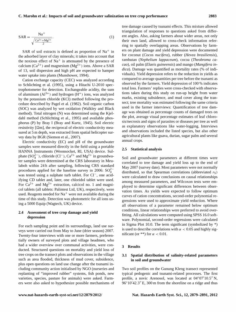
All plots analyzed in the study area could be grouped intofour major types of temporal dynamics of groundwater salin-ity. The first type reflected effects of the tsunami per se; thesecond and third type were additionally influenced by theflood event in 2007, and the fourth type showed no effect.Figure 4 shows a selection of four transects that include plotsrepresentative for each type:
i. Rapid desalinization to stable low values: the tsunami-induced EC of up to 12 mS cm−1 in 2006 decreasedto values below 2 mS cm−1 within one year. This pat-tern was observed on plots KT 300 to 500 and SS100(Fig. 4), characterized by free-draining sandy soils, typ-ically situated on beach ridges that were not stronglyinfluenced by changing depth of the groundwater table.
ii. Plots flooded in 2007 (marked with asterisks in Fig. 4)were all close to the seashore (KT150 to 250, ST150 to700 and SP200 to 350). Salinity levels in 2007 startedfrom a lower level than in 2004 (see Subiksa et al.,2006b), and also returned to pre-flood levels within oneseason.
iii. Plots indirectly affected by the 2007 flood were foundalong transect ST up to 1200 m land inward in the
rubber forest on peat soil, and also at SS500, whereEC in 2007 quadrupled as compared to 2006 levels,although the plot had not been flooded. These plotsshowed an increase in salinity beyond seasonal oscilla-tion after May 2007 due to a network of drainage chan-nels extending from the slightly elevated peat domes to-wards the sea. During and after the flood, flow directionin these channels was reversed and saline water laterallyinfiltrated into soils. However, rapid restoration to pre-flood EC levels was observed, as on all plots affected bythe 2007 flooding.
iv. Plots showed no direct tsunami or flood impact but sea-sonal oscillations in EC between drier and wet season2007, representing the longer-term and large-scale ef-fects of the tsunami event. These were KT400, 700 and900, SN and, with increasing distance from seawaterand elevation, AR150 to 200 and CL (not shown).
3.3 Interactions between soil and groundwater
In 2007 depth of the groundwater table differed significantlybetween seasons (Wilcoxon Signed Ranks test), despite theflood event during the drier season. For the wet season 2007,groundwater depth and EC of soils were significantly nega-tively correlated (rS = −0.46**; n = 46), meaning that an in-crease in groundwater table corresponded to increasing salin-ity in the soil profile. Thus, salinity increased with the highergroundwater table rather than salt concentrations being di-luted by rainwater (Fig. 5).
www.nat-hazards-earth-syst-sci.net/12/2879/2012/ Nat. Hazards Earth Syst. Sci., 12, 2879–2891, 2012
2886 C. Marohn et al.: Impacts of soil and groundwater salinization on tree crop performance
Fig. 4. Temporal dynamics of groundwater salinity from 2006–2008 along four transects in Aceh Barat:(a) Kampong Teungoh;(b) SuakTimah; (c) Suak Puntong;(d) Suak Sigadeng. Numbers after village identifiers indicate distance to the sea in metres. Plots flooded in 2007are marked with asterisks.
Mud thickness as source of and proxy for salinity showedstronger correlations to groundwater pH (rS = 0.79**) andgroundwater Mg2+ concentrations (rS = 0.77**) as com-pared to soil EC (rS = 0.63*), which supposedly reactedmore slowly and in a more buffered way to changes. RelativeNa+ accumulation around 30 cm profile depth, as in Bw1 ofthe novic Arenosol and Bw of the arenic Gleysol (Tables 1and 2), showed that the leaching front was determined by adynamic equilibrium of saline groundwater and rainwater in-filtration.
3.4 Tree crop damage and yield depression
During the tsunami event, flooding with seawater ofEC> 40 mS cm−1 lasted for up to five hours and, depend-ing on inundation time, tree crops were severely damaged inlarge parts of Aceh Barat (Subiksa et al., 2006b). Accord-ing to farmers (interviewed in 2007), damage symptoms be-came visible within 6 to 12 months after the flooding. Acrossall plots, cocoa, rambutan and mango were most severely af-fected by the tsunami event and its longer-term consequences(Fig. 6). Farmers’ assessment of mango damage in 2005 wasbetween 80 and 100 % on all except one plot, and 95 to 100 %for all affected rambutan plots. Coconut, rubber and oil palm
Fig. 5. EC in groundwater (wet season 2007) and two soil layers(May 2007) in relation to groundwater depth.
were less severely affected. Yield depression followed a sim-ilar pattern as tree damage.
In addition to farmer interviews, which integrated the pe-riod from 2005 to 2007, inventories in 2007 were conducted
Nat. Hazards Earth Syst. Sci., 12, 2879–2891, 2012 www.nat-hazards-earth-syst-sci.net/12/2879/2012/

C. Marohn et al.: Impacts of soil and groundwater salinization on tree crop performance 2887
Fig. 6. Tree damage and yield loss in 2005 as reported by farmersand tree damage according to inventories during this study in 2007.Numbers of observations refer to cases of damage as observed in2007, and damage and yield loss 2005 reported in retrospective byfarmers.
as a cross-check. For coconut and rubber, stubs of brokentrees were still visible in 2007 and both inventories agreedwell. Where entire plots had been cleared or partially re-planted, as for cocoa and mango, damage counts divergedbetween years. Overall, no significant differences betweenfarmers’ and damage assessment carried out during this studywere found where identical spots were assessed (Wilcoxonsigned rank test). Farmers’ memory, collective history andcaducity of obvious signs appeared not to affect validity ofthe data.
3.5 Effects of soil and groundwater parameters onplants
Despite the rapid decline in salinity after the flooding,groundwater remained saline enough on several transects todominate soil Na+ concentrations and EC once the ground-water table shifted upwards into the rooting space duringrainy seasons. Substantial dilution of groundwater by rain-water was not observed. Both long-term soil salinity as wellas short-term groundwater oscillations can lead to osmoticstress, Na+ toxicity or cation imbalances. Underlying causescould not be differentiated in the field, but statistical relation-ships between tree damage and soil and groundwater charac-teristics across all transects allowed to draw some conclu-sions on potential causes for plant damage and lower yieldsas reported by farmers.
3.5.1 Plant damage
Coconut trees were mostly planted near the coast, and thustree damage was clearly related to mechanical forces; corre-lations of damage to run-up height (rS = 0.79**; n = 14) and
distance to the sea (rS = −0.40*; n = 25) were significantand strong. Significant correlations also existed to soil elec-tric resistivity, the reciprocal of conductivity (rS = −0.52**;n = 27), groundwater Ca2+ (rS = 0.43*; n = 23) and pH(rS = 0.46*; n = 23) in 2007.
Rubber and fruit trees were mostly grown at larger dis-tance (more than 200 to 400 m) from the sea, and damagewas not correlated to direct physical impact. Damage wasstrongly correlated to soil electric resistivity, (rS = −0.72*;n = 11) and soil Na+ concentrations (rS = 0.65*; n = 11).Correlations to groundwater depth (rS = −0.69*; n = 10)and groundwater EC measured in 2006 (rS = 0.62, α =
0.05;n = 10) were not expected, because rubber was widelygrown on peat domes with insufficient drainage. Damage wasthus seen in context with salinity brought by the groundwater,as shown for reversed water flow through drainage channelson transect ST (Fig. 4).
Mango damage was correlated to groundwater EC duringthe drier season 2007 (rS = 0.54*, n = 15). For both mangoand rubber, farmers reported partial detoxification by leafshedding. For rambutan damage, a strong statistical relation-ship was observed against groundwater depth (rS = 0.76*),implying that the effect could have been caused either di-rectly by groundwater level or by groundwater salinity. Re-curring effects of salinity on cocoa could be observed in 2007on transect GK, where recently planted seedlings showedtypical leaf necroses.
3.5.2 Yield depression
Yield depression was statistically related to other factors thanplant damage. Sufficient numbers of farmer reports for sta-tistical interpretation were obtained only for coconut andrubber. Yield depression in coconut was negatively corre-lated to groundwater Mg2+ concentration in 2007 (rS =
−0.77**; n = 10), and a linear regression withr2= 0.44
(Fig. 7a) pointed to Mg2+ deficiency. Accordingly, farmersoften stated that more nuts with lower individual weight hadbeen harvested in the years following the tsunami. At thesame time, yield depression in response to groundwater Ca2+
concentrations and pH followed a minimum curve with leastyield reduction observed on plots around pH 5.
In contrast to coconut, rubber yield depression was gen-erally high, between 40 and 100 % (Fig. 7b). Strong corre-lations existed to groundwater Cl− in 2006 (rS = 0.75*) andsoil EC (rS = 0.71*) as well as to soil pH at 20 to 40 cm depth(rS = −0.73*), pointing to improved growth conditions onthe more alkaline plots. Rubber prefers soil pH between 5and 6 and tolerates pH 4 to 8 (Rehm and Espig, 1991), whilerubber soils in the area were mostly between 3 and 6.5. In-fluence of the groundwater was indicated by the fact thatrubber yield depression (n = 10) was linked to subsoil Na+
(rS = 0.90**) more clearly than to topsoil Na+ (rS = 0.80*).On the other hand, given that rubber is naturally adapted to
www.nat-hazards-earth-syst-sci.net/12/2879/2012/ Nat. Hazards Earth Syst. Sci., 12, 2879–2891, 2012

2888 C. Marohn et al.: Impacts of soil and groundwater salinization on tree crop performance
(a)
(b)
Fig. 7. Response of yield depression in coconut(a) and rubber(b)to soil and groundwater conditions.
periodical water-logging (Kozlowski, 1997), effects of highgroundwater per se are unlikely.
The potentially toxic Na+ and Cl− ions formed thresholds(around 3 cmol Na+ kg soil−1 and 100 mg Cl l−1 groundwa-ter, resp.), above which yields almost completely failed.
4 Discussion
In accordance with previous studies, e.g. Villholth etal. (2005) for Sri Lanka, Rachman (2008) for Aceh, the firstmain finding of this study was the rapid decline of salinity af-ter the tsunami. Subiksa et al. (2006a) attributed this effect tothe sandy texture, low SOM and CEC of the coastal soils inAceh, which was confirmed on all plots of the present study.The same decline was observed after the post-tsunami floodevent in 2007. This event served as a proxy of groundwa-ter dynamics immediately after the tsunami, which had notbeen part of the field measurements carried out during thisstudy (from 2006 onwards). Second, it was observed that soilsalinity-related parameters reflected groundwater dynamics,with a time lag and less extreme maxima. Soil salinizationwas determined by short-term dynamics due to inundationwith sea water and longer-lasting gradual release of saltsfrom tsunami sediments (McLeod et al., 2010). Third, thisstudy showed a periodic increase of groundwater and soilsalinity during rainy seasons, a phenomenon that has notreceived much attention in tsunami research. The fact thatgroundwater table as well as groundwater and soil salinityincreased significantly during the rainy season 2007, despitethe flooding in the drier season, suggests that this increaseoccurs to the same or higher extent in other years, too. Like-wise, Rachman (2008) found drastically elevated soil salin-ity during seasons of high groundwater table in Aceh Pidieand Aceh Besar, 250 km from the area in this study. Thisimplies that the diluting effect of rainfall was overruled byion release from tsunami mud and uplift of saline ground-water. It can be assumed that upward movement of saltwa-ter in the soil (leading to higher EC at higher groundwaterlevels) may have been caused by groundwater recharge inthe more elevated hinterland and peat areas during the wetseason, exerting upward pressure on the saline groundwaterbodies closer to the coast. The deeper parts of these ground-water aquifers, originating in the hills, were tapped for newwells installed after the tsunami. Alternatively, a model de-veloped by Illangasekare et al. (2006) for Sri Lanka, assumesthat tsunami seawater infiltrated a freshwater lens situatedabove a seawater wedge. The mixed water body would thenbe subject to seasonal oscillations of the groundwater table.Given the high annual precipitation in Aceh Barat, it can beassumed that groundwater and seawater bodies are still con-nected in places where geomorphology has been altered bythe tsunami. Fourth, the observed effects of soil salinizationextended outside the flooded areas, presumably driven by lat-eral infiltration of groundwater. In the soil profiles analyzedfor this study, leaps of single cation concentrations werefound. In contrast to a typical leaching front, this boundaryis assumedly shifted upwards during rainy seasons.
As these effects prevail in groundwater-influenced soilhorizons, available rooting space above groundwater levelplayed a decisive role for salinity effects on plants. In thiscontext, the influence of small-scale topography – ridges and
Nat. Hazards Earth Syst. Sci., 12, 2879–2891, 2012 www.nat-hazards-earth-syst-sci.net/12/2879/2012/
C. Marohn et al.: Impacts of soil and groundwater salinization on tree crop performance 2889
swales oriented in parallel direction to the coastline – wasdecisive for mud deposition, groundwater table and plantgrowth. Umitsu et al. (2007) found that route and intensityof the tsunami backwash were mainly determined by mi-crorelief on the beaches; during the sedimentation process,depressions were filled up with mud first (Rachman, 2008;Paris et al., 2007), as reflected in our study by alternatingpoints of high and low salinity in the monitored transects(e.g. KT, SS). Thus, groundwater level is seen as a functionof micro-relief, influential for plant growth in the mid to longrun. Effects of scale became obvious when relief-related pa-rameters measured at different spatial resolution were corre-lated: Mud thickness, groundwater pH and Mg2+ measuredat the 48 transect points were well-correlated among eachother, and so were mud thickness and resistivity at 5 m depthextracted for the same points from interpolated large-scalemaps from the ReGrIn project and Siemon et al. (2007), re-spectively. Between point data and interpolated data, how-ever, no significant correlation was found.
While most tsunami research after 2004 concentrated ondamage to humans and property, our study links groundwa-ter and soil salinity-related parameters and their effects onagriculture, in particular tree crops, which are deep root-ing and thus sensitive in areas of shallow groundwater ta-ble. Apart from initial salinization and water-logging oftsunami-affected soils, recurring salinity and cation imbal-ances during periods of high groundwater levels or lat-eral flow were the most relevant impact factors constrain-ing tree crop growth in post-tsunami Aceh Barat. Givenmore than 3600 mm average rainfall per year, leaching ofsalts out of the soil was not limited by source, but by sink,i.e. groundwater-influenced soil horizons. Recommendationstargeting shallow-rooting annual crops, such as increasingsoil organic matter contents or facilitating flushing and leach-ing (Slavich et al., 2008), will be largely ineffective for treecrops, once rooting systems extend into saline soil horizons.Although tree crops may dispose of detoxification by mech-anisms like leaf shedding, damage caused by salinity and as-sociated yield depression may last longer than for annuals.
Mechanical damage to tree crops could clearly be relatedto distance from the sea shore, in accordance with findingson human mortality and damage to buildings in the same area(Laso Bayas et al., 2011). Consequently, mostly coconut wasaffected by breakage, while other tree crops suffered fromsalinity-related impact. This is in line with agronomic dataabout salt sensitivity of rambutan (FAO and MOAC, 2005)and mango and notorious salt tolerance of coconut (FAO,2005).
Yield depression was often indirectly related to micro-relief effects, e.g. in the case of rubber and mango. Here,depth of the – saline – groundwater table affected soiland groundwater pH and single ion concentrations, whichchanged markedly after the tsunami. Rubber yield depressionwas correlated stronger to Na+ in the subsoil than in the top-soil, pointing to advanced leaching of seawater and recurring
effects of groundwater. Effects of groundwater pH on plantsappeared less influential than those of salinity. Although lit-erature on salinity or seawater effects on rubber is scarce, therole of K+ for latex flow rates is well-known (Pushparajahand Guha, 1969) and KCl fertilization of rubber is reportedfor saline soils in Eastern Thailand (Mak et al., 2008), sothat competitive effects between Na+ and K+ (in the soil orplant) may explain reduction in latex yield. The fact that awide range of pH values was found across the rubber plotspoints to Na+ as most influential factor for yield depression.
Despite their position further land inward, none of the sur-veyed rubber plots had less than 40 % yield depression, sim-ilar to the high damage levels in rambutan, cocoa and partlymango. Coconut trees were less affected by physiologicalconstraints despite being exposed to higher salinity and al-kalinity. Where Mg2+ was deficient despite its high concen-trations in tsunami mud, it may have been displaced by com-parably higher concentrations of Ca2+ ions from exchangesites or competed for uptake into plants. This is in line withreports and analyses of coconut leaves exhibiting chlorosisas a symptom of Mg2+ deficiency (Subiksa et al., 2006b).A comparative advantage of coconut over other trees mayhave been their superficial rooting system. Deep rooting treeswere better anchored in the soil and thus more resistant to thephysical impact of the tsunami. On the other hand, they weremore exposed to the longer-lasting effects of saline ground-water during rainy seasons.
As modifications to the landscape relief, hydrology andecology are currently effectuated at larger scale (introduc-tion of new industrial crops like oil palm in large estates re-placing jungle rubber) and negative effects become visible(peat drainage followed by slash and burn, soil compaction,among others), the importance of crop-site matching cannotbe overemphasized, to which tsunami reconstruction effortsdid not always adhere (Laso Bayas et al., 2011). In sum-mary, tree crops most affected by flooding were those plantedoutside their natural habitat. Replanting of tree crops shouldconsider adapted species such asNypa fruticansand othertree crops that are resistant to seawater and at the same timeconsider initial investments and profitability (Mattsson et al.,2009).
Imposed by the circumstances during the tsunami after-math, this study is based on a limited number of repeatedobservations on a coastal strip of about 40 km and does notrepresent a spatially exhaustive dataset. Still, general trendsof groundwater and soil salinity distribution and temporal dy-namics could be identified, which add new aspects to existingresearch.
5 Conclusions
Spatially, salinization patterns were determined by distanceto salt water bodies, unless overruled by the influence ofgroundwater level, e.g. in places of lower elevation near
www.nat-hazards-earth-syst-sci.net/12/2879/2012/ Nat. Hazards Earth Syst. Sci., 12, 2879–2891, 2012
2890 C. Marohn et al.: Impacts of soil and groundwater salinization on tree crop performance
ditches or swales. Temporally, flood- and mud-borne salin-ity of soils decreased quickly after a flooding event, butrecurring elevated salinity was observed during seasons ofhigh groundwater levels. Groundwater salinity reacted morequickly and more strongly to flood events, while the soilbuffered salinity over longer periods. Fruit trees – mango,rambutan, cocoa – were generally sensitive to the tsunami ef-fects, and mortality was high. Disentangling effects of highgroundwater level and salinity on fruit tree mortality were notpossible, while the most influential damaging factors for co-conut were mechanical forces and for rubber salinity-relatedsoil and groundwater parameters. Yield depression of co-conut appeared to be related mainly to cation imbalances inthe groundwater, while rubber yields were affected by soilsodium contents (possibly interfering with K uptake) andgroundwater pH. Given the large areas affected and the re-curring and thus long-lasting effects particularly trees are ex-posed to under these conditions, modification of the soil andlandscape appears to be of limited efficacy to improve grow-ing conditions. Selection of shallow rooting or salt-resistantcrops for agriculture appears to be a more promising strategy.Apart from profitability of these plants, protective effects incase of expected future tsunamis should be considered.
Acknowledgements.Bundesanstalt fur Geowissenschaften undRohstoffe, Hannover, Germany, provided resistivity maps of thestudy region. Aulia Firdaus was essential for reliable and thoroughsampling and logistic support on site. Yohannes Zergaw Ayanu andThi Thanh Nguyen elaborated the maps. This study was carriedout within the ReGrIn project, Rebuilding Green Infrastructurewith Trees People Want, funded by the European Commissionthrough the ECO ASIA IIb programme (ASIE 2005/111/657). Weare grateful to Peter Slavich and an anonymous reviewer for theircomments on an earlier version of this paper.
Edited by: S. TintiReviewed by: P. Slavich and one anonymous referee
References
Agus, F., Subagjo, H., Rachman, A., and Subiksa, I. G. M.: Proper-ties of Tsunami Affected Soils and the Management Implication,2nd Int Salinity Forum, Adelaide, Australia 31 March–3 April2008, available at:www.internationalsalinityforum.org(last ac-cess: 16 March 2010), 2008.
Badan Meteorologi dan Geofisika, Stasiun Meteorologi Meulaboh:Data Curah Hujan Tahun 2004–2007. Badan Meteorologi danGeofisika, Meulaboh, Indonesia, 2008.
Bray, R. H. and Kurtz, L. T.: Determination of total organic andavailable forms of phosphorus in soils, Soil Sci., 59, 39–45, 1945.
Chaerun, S. K., Wirth, S., Ulrich, A., Ellerbrock, R. H., andMaassen, S.: Impact of seawater flooding caused by the 26 De-cember 2004 tsunami disaster on physico-chemical and micro-bial properties of arable soils in Banda Aceh, Indonesia, in:Book of Abstracts Eurosoil, 25–29 August 2008, Vienna, Aus-tria, p. 36, 2008.
Chaudary, D. R., Ghosh, A., and Patolia, J. S.: Characterizationof soils in the tsunami-affected coastal areas of Tamil Nadu foragronomic rehabilitation, Curr. Science, 91, 99–104, 2006.
FAO: Field Guide – 20 things to know about the impact of salt wateron agricultural land in Aceh province, FAO, Rome, 2005.
FAO and MOAC: Report of Joint FAO/MOAC Detailed TechnicalDamages and Needs Assessment Mission in Fisheries and Agri-culture Sectors in Tsunami Affected Six Provinces in Thailand,11–24 January 2005, FAO, Rome, 2005.
FAO, ISRIC and ISSS: World Reference Base for Soil Resources,FAO, Rome, 2006.
Illangasekare, T., Tyler, S. W., Clement, T. P., Villholth, K. G., Per-era, A., Obeysekera, J., Gunatilaka, A., Panabokke, C. R., Hyn-dman, D. W., Cunningham, K. J., Kaluarachchi, J. J., Yeh, W.W., van Genuchten, M. T., and Jensen, K.: Impacts of the 2004tsunami on groundwater resources in Sri Lanka, Water Resour.Res., 42, 1–9, 2006.
Joshi, L. and Nugraha, E.: Livelihood and environment in Acehand Nias: The role of tree crops in post-tsunami development,in: Proc Int Symp Land Use after the Tsunami: Supporting Ed-ucation, Research and Development in the Aceh Region, BandaAceh, 4–6 November 2008, 2008.
Kozlowski, T. T.: Responses of woody plants to flooding and salin-ity, Tree Physiol. Monogr., Heron Publishing, Victoria, Canada,1997.
Laso Bayas, J. C., Marohn, C., Dercon, G., Dewi, S., Piepho, H.P., Joshi, L., van Noordwijk, M., and Cadisch, G.: Influence ofcoastal vegetation on the 2004 tsunami wave impact in westAceh, Proc. Natl. Aca. Sci., 108, 18612–18617, 2011.
Mak, S., Chinsathit, S., Pookpakdi, A., and Kasemsap, P.: The effectof fertilizer and irrigation on yield and quality of rubber (Heveabrasiliensis) grown in Chanthaburi Province of Thailand, Kaset-sart, J. Nat. Sci., 42, 226–237, 2008.
Mattsson, E., Ostwald, M., Nissanka, S. P., Holmer, B., and Palm,M.: Recovery and protection of coastal ecosystems after tsunamievent and potential for participatory forestry CDM – Examplesfrom Sri Lanka, Ocean Coast. Manag., 52, 1–9, 2009.
McLeod, M. K., Slavich, P. G., Irhas, Y., Moore, N., Rachman, A.,Ali, N., Iskandar, T., Hunt, C., and Caniago, C.: Soil salinity inAceh after the December 2004 Indian Ocean tsunami, Agr. WaterManage., 97, 605–613, 2010.
Munshower, F. F.: Practical Handbook of Disturbed Land Revege-tation, Lewis, Boca Raton, Florida, 1994.
Pagel, H., Enzmann, J., and Mutscher, H.: Pflanzennahrstoffe intropischen Boden – ihre Bestimmung und Bewertung, DeutscherLandwirtschaftsverlag, Berlin, 1982.
Paris, R., Lavigne, F., Wassmer, P., and Sartohadi, J.: Coastal sed-imentation associated with the December 26, 2004 tsunami inLok Nga, West Banda Aceh (Sumatra, Indonesia), Mar. Geol.,238, 93–106, 2007.
Pushparajah, E. and Guha, M. M.: Fertilizer response in Heveabrasiliensis in relation to soil type and leaf nutrition studies,Transactions of the Ninth International Congress on Soil ScienceAdelaide, 1969.
Rachman, A.: Rehabilitation of tsunami-affected soil in NAD, in:Proc Int Symp Land Use after the Tsunami: Supporting Edu-cation, Research and Development in the Aceh Region, BandaAceh, 4–6 November 2008, 2008.
Nat. Hazards Earth Syst. Sci., 12, 2879–2891, 2012 www.nat-hazards-earth-syst-sci.net/12/2879/2012/

C. Marohn et al.: Impacts of soil and groundwater salinization on tree crop performance 2891
Rehm, S. and Espig, G.: The cultivated plants of the Tropics andSubtropics, Margraf Verlag, Weikersheim, 1991.
Schlichting, E., Blume, H. P., and Stahr, K.: Bodenkundliches Prak-tikum. Blackwell, Berlin, 1995.
Schollenberger, C. J. and Simon, R. H.: Determination of exchangecapacity and exchangeable bases in soils – ammonium acetatemethod, Soil Sci., 59, 13–24, 1945.
Shofiyati, R., Dimyati, R. D., Kristijono, A., and Wahyunto:Tsunami effect in Nanggroe Aceh Darussalam and North Suma-tra Provinces, Indonesia, Asian J. Geoinform., 5, 100–111, 2005.
Siemon, B., Steuer, A., Meyer, U., and Rehli, H.-J.: HELP ACEH –A post-tsunami helicopter-borne groundwater project along thecoasts of Aceh, northern Sumatra, Near Surf. Geophys., 5, 231–240, 2007.
Slavich, P., McLeod, M., Moore, N., Tinning, G., Lines-Kelly, R.,Iskandar, T., Rachman, A., Agus, F., and Yufdy, P.: Tsunami im-pacts on farming in Aceh and Nias, Indonesia,. 2nd Int SalinityForum, Adelaide, Australia 31 March–3 April 2008, availableat: www.internationalsalinityforum.org(last access: 16 March2010), 2008.
Subiksa, I. G. M. and Agus, F.: Salinity dynamics of tsunami af-fected soils in the coastal area of West Aceh, in: Proc Int SympLand Use after the Tsunami: Supporting Education, Researchand Development in the Aceh Region, Banda Aceh, 4–6 Novem-ber 2008, 255-258, 2008.
Subiksa, I. G. M., Agus, F., and Erfandi, D.: The salt leached out andthe soil fertility changes after tsunami, ICRAF Research BulletinNovember 2006, ICRAF South East Asia, Bogor, 2006a.
Subiksa, I. G. M., Agus, F., and Erfandi, D.: Soil monitoringand tree crops adaptability after tsunami in West Aceh district,Report, Indonesian Soil Research Institute, Bogor, Indonesia,2006b.
Szczucinski, W., Chaimanee, N., Niedzielski, P., Rachlewicz, G.,Saisuttichai, D., Tepsuwan, T., Lorenc, S., and Siepak, J.: En-vironmental and Geological Impacts of the 26 December 2004Tsunami in Coastal Zone of Thailand – Overview of Short andLong-Term Effects, Pol. J. Environ. Stud., 15, 793–810, 2006.
The Consultative Group of Indonesia (CGI): Indonesia: Prelim-inary damage and loss assessment. The December 26, 2004Natural Disaster, Report, BAPPENAS, Jakarta, available at:www.unep.org/tsunami/reports/damageassessment.pdf(last ac-cess: 16 March 2012), 2005.
Umitsu, M., Tanavud, C., and Patanakanog, B.: Effects of landformson tsunami flow in the plains of Banda Aceh, Indonesia, and NamKhem, Thailand, Mar. Geol., 242, 141–153, 2007.
Verrelst, J. and Schaepman, M. E.: Damage assessment of a coastalplain based on satellite imagery, in: Your environment is our con-cern: A catalogue of worldwide environmental research, Alterraand the Environmental Sciences Department of Wageningen Uni-versity, Netherlands, 78–81, 2007.
Villholth, K. G., Amerasinghe, P. H., Jeyakumar, P., Panabokke, C.R., Woolley, O., Weerasinghe, M. D., Amalraj, N., Prathepaan,S., Burgi, N., Lionelrathne, D. M., Indrajith, N. G., and Pathirana,S. R.: Tsunami Impacts on Shallow Groundwater and AssociatedWater Supply on the East Coast of Sri Lanka, IWMI, Colombo,Sri Lanka, 2005.
Wahyunto, Ritung, S., Wahdini, W., and Agus, F.: AlternativeTree Crops for Reconstruction of the Green Infrastructure Post-Tsunami in the Coastal Areas of Aceh Barat District, IndonesianJ. Agr. Sci., 10, 1–11, 2009.
www.nat-hazards-earth-syst-sci.net/12/2879/2012/ Nat. Hazards Earth Syst. Sci., 12, 2879–2891, 2012


![Groundwater circulation relative to water quality and ...channel surface water and local groundwater (Figure 1). The main crop is cotton. Zhou et al. [35] investigated the groundwater](https://static.fdocuments.in/doc/165x107/5ed99b87801c872007065bd5/groundwater-circulation-relative-to-water-quality-and-channel-surface-water.jpg)