Impact of the December 24, 2004 Tsunami on coral reefs...
6
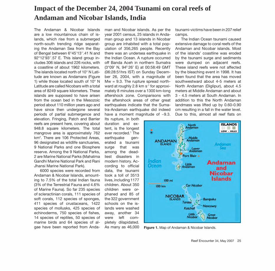
Reef Encounter 34, May 2007 25 Impact of the December 24, 2004 Tsunami on coral reefs of Andaman and Nicobar Islands, India The Andaman & Nicobar Islands are a low mountainous chain of is- lands, which rise from a submerged north-south trending ridge separat- ing the Andaman Sea from the Bay of Bengal between 6°45ʹ13ʹʹ.41 N and 92°12ʹ93ʹʹ.57 E. This island group in- cludes 306 islands and 226 rocks, with a coastline of about 1962 kilometers. The islands located north of 10° N Lati- tude are known as Andamans (Figure 1) while those located south of 10° N Latitude are called Nicobars with a total area of 8249 square kilometers. These islands are supposed to have arisen from the ocean bed in the Mesozoic period about 110 million years ago and have since then undergone several periods of partial submergence and elevation. Fringing, Patch and Barrier reefs are present here, covering about 948.8 square kilometers. The total mangrove area is approximately 762 km 2 . There are 106 Protected Areas, 96 designated as wildlife sanctuaries, 9 National Parks and one Biosphere reserve. Among the 9 National Parks, 2 are Marine National Parks (Mahatma Gandhi Marine National Park and Rani Jhansi Marine National Park). 6000 species were recorded from Andaman & Nicobar Islands, amount- ing to 7.5% of the total Indian fauna (3% of the Terrestrial Fauna and 4.6% of Marine Fauna). So far 235 species of scleractinian corals, 111 species of soft corals, 112 species of sponges, 411 species of crustaceans, 1422 species of mollusks, 425 species of echinoderms, 750 species of fishes, 14 species of reptiles, 50 species of marine birds and 64 species of al- gae have been reported from Anda- man and Nicobar islands. As per the year 2001 census, 25 islands in Anda- man group and 13 islands in Nicobar group are inhabited with a total pop- ulation of 356,265 people. Recently there was an undersea earthquake in the Indian Ocean. A rupture occurred off Banda Aceh in northern Sumatra (3°09’ N, 94 0 26’ E) at 00:58:49 GMT (06:28:51hrs IST) on Sunday Decem- ber 26, 2004, with a magnitude of Mw = 9.3. The rupture spread north- ward at roughly 2.8 km s -1 for approxi- mately 8 minutes over a 1300 km-long aftershock zone. Comparisons with the aftershock areas of other great earthquakes indicate that the Suma- tra-Andaman earthquake did indeed have a moment magnitude of ~9.3. Its rupture, in both duration and ex- tent, is the longest ever recorded. 1 The earthquake gen- erated a tsunami surge that was among the dead- liest disasters in modern history. Ac- cording to official data, the tsunami took a toll of 3513 lives, including 1177 children. About 350 children were or- phaned and 85 of the 322 government schools on the is- lands were washed away, another 34 were left com- pletely dilapidated. As many as 46,000 tsunami-victims have been in 207 relief camps. The Indian Ocean tsunami caused extensive damage to coral reefs of the Andaman and Nicobar islands. Most of the islands’ coastline was eroded by the tsunami surge and sediments were dumped on adjacent reefs. These island reefs were not affected by the bleaching event in 1998. It has been found that the area has moved southwestward about 4-5 meters at North Andaman (Diglipur), about 4.5 meters at Middle Andaman and about 3 - 4.5 meters at South Andaman. In addition to this the North Andaman landmass was lifted up by 0.60-0.90 cm resulting in a fall in the water level. Due to this, almost all reef flats on Figure 1. Map of Andaman & Nicobar Islands.
Transcript of Impact of the December 24, 2004 Tsunami on coral reefs...
Reef Encounter 34, May 2007 25
CURRENTS
vide are compromised. Management via marine reserves must be applied in conjunction with other conserva-tion actions such as the improvement of the water quality and run-off con-trol. We must ensure that the sporadic events of recovery revealed in some
reef sites over the past few years ac-tually persist and extend to other Ca-r ibbean reefs. We believe that only a multinational Caribbean-wide conser-vation strategy will ensure the survival of these ecosystems.
Gustavo A. ParedesCenter for Marine Conservation and
BiodiversityScripps Institution of Oceanography
University of California San Diego9500 Gilman Dr.
La Jolla, CA 92093-0208
Impact of the December 24, 2004 Tsunami on coral reefs of Andaman and Nicobar Islands, India
The Andaman & Nicobar Islands are a low mountainous chain of is-lands, which rise from a submerged north-south trending ridge separat-ing the Andaman Sea from the Bay of Bengal between 6°45ʹ13ʹʹ.41 N and 92°12ʹ93ʹʹ.57 E. This island group in-cludes 306 islands and 226 rocks, with a coastline of about 1962 kilometers. The islands located north of 10° N Lati-tude are known as Andamans (Figure 1) while those located south of 10° N Latitude are called Nicobars with a total area of 8249 square kilometers. These islands are supposed to have arisen from the ocean bed in the Mesozoic period about 110 million years ago and have since then undergone several periods of partial submergence and elevation. Fringing, Patch and Barrier reefs are present here, covering about 948.8 square kilometers. The total mangrove area is approximately 762 km2. There are 106 Protected Areas, 96 designated as wildlife sanctuaries, 9 National Parks and one Biosphere reserve. Among the 9 National Parks, 2 are Marine National Parks (Mahatma Gandhi Marine National Park and Rani Jhansi Marine National Park).
6000 species were recorded from Andaman & Nicobar Islands, amount-ing to 7.5% of the total Indian fauna (3% of the Terrestrial Fauna and 4.6% of Marine Fauna). So far 235 species of scleractinian corals, 111 species of soft corals, 112 species of sponges, 411 species of crustaceans, 1422 species of mollusks, 425 species of echinoderms, 750 species of fi shes, 14 species of reptiles, 50 species of marine birds and 64 species of al-gae have been reported from Anda-
man and Nicobar islands. As per the year 2001 census, 25 islands in Anda-man group and 13 islands in Nicobar group are inhabited with a total pop-ulation of 356,265 people. Recently there was an undersea earthquake in the Indian Ocean. A rupture occurred off Banda Aceh in northern Sumatra (3°09’ N, 940 26’ E) at 00:58:49 GMT (06:28:51hrs IST) on Sunday Decem-ber 26, 2004, with a magnitude of Mw = 9.3. The rupture spread north-ward at roughly 2.8 km s-1 for approxi-mately 8 minutes over a 1300 km-long aftershock zone. Comparisons with the aftershock areas of other great earthquakes indicate that the Suma-tra-Andaman earthquake did indeed have a moment magnitude of ~9.3. Its rupture, in both duration and ex-tent, is the longest ever recorded.1 The earthquake gen-erated a tsunami surge that was among the dead-liest disasters in modern history. Ac-cording to offi cial data, the tsunami took a toll of 3513 lives, including 1177 children. About 350 children were or-phaned and 85 of the 322 government schools on the is-lands were washed away, another 34 were left com-pletely dilapidated. As many as 46,000
tsunami-victims have been in 207 relief camps.
The Indian Ocean tsunami caused extensive damage to coral reefs of the Andaman and Nicobar islands. Most of the islands’ coastline was eroded by the tsunami surge and sediments were dumped on adjacent reefs. These island reefs were not affected by the bleaching event in 1998. It has been found that the area has moved southwestward about 4-5 meters at North Andaman (Diglipur), about 4.5 meters at Middle Andaman and about 3 - 4.5 meters at South Andaman. In addition to this the North Andaman landmass was lifted up by 0.60-0.90 cm resulting in a fall in the water level. Due to this, almost all reef fl ats on
Figure 1. Map of Andaman & Nicobar Islands.

the western side of northern group of islands (i.e west coast of Interview Island, North Reef Island, Latouche Island, South Reef Island, West Is-land, Landfall Island, East Island and Anderson Island) were exposed and dried up (Fig 2-5). Almost all corals in the reef fl ats and other associated fauna seemed dead beyond regener-ation, appearing like a graveyards of corals. The corals in reef slope were not as affected by the tsunami and the live coral percentage is 55-60%. In contrast, South Andaman subsided
by 1-2 m, and seawater inundated the agriculture fi elds and coastal mangroves. The western coast of the North Sentinel Island, which is further south in South Andaman, was uplifted by half a meter.
Extensive coral reef surveys were made at Mahatma Gandhi Marine National Park at South Andaman dur-ing the month of January 2005 using SCUBA diving and snorkeling. It con-sists of 15 islands of different sizes, scattered over a total area of 281.50 km2. In Jolly Buoy, Redskin and North
Bay reefs, overturning of large corals especially Porites lutea colonies was observed. There was more damage on the northeastern side of Jolly Buoy Island where nearly 10m2 of reef area was covered by sand. The Jolly Buoy Island lies in a northeast/southwest di-rection. On the northeastern side, the beaches and near shore land areas were around 6-10 m wide and were devastated by the tsunami. At one site, nearly 20m2 area of coral reef was buried under the sediment and no cor-als were visible. Most of the branching
CURRENTS
Figure 4. Incredible coral damage around North Reef.
Figure 5. Mass mortality of corals at reef fl ats of Interview Is-land.
Figures 2&3. Mass mortality of corals on reef fl at at Anderson Island.
26 Reef En coun ter 34, May 2007
Reef Encounter 34, May 2007 27
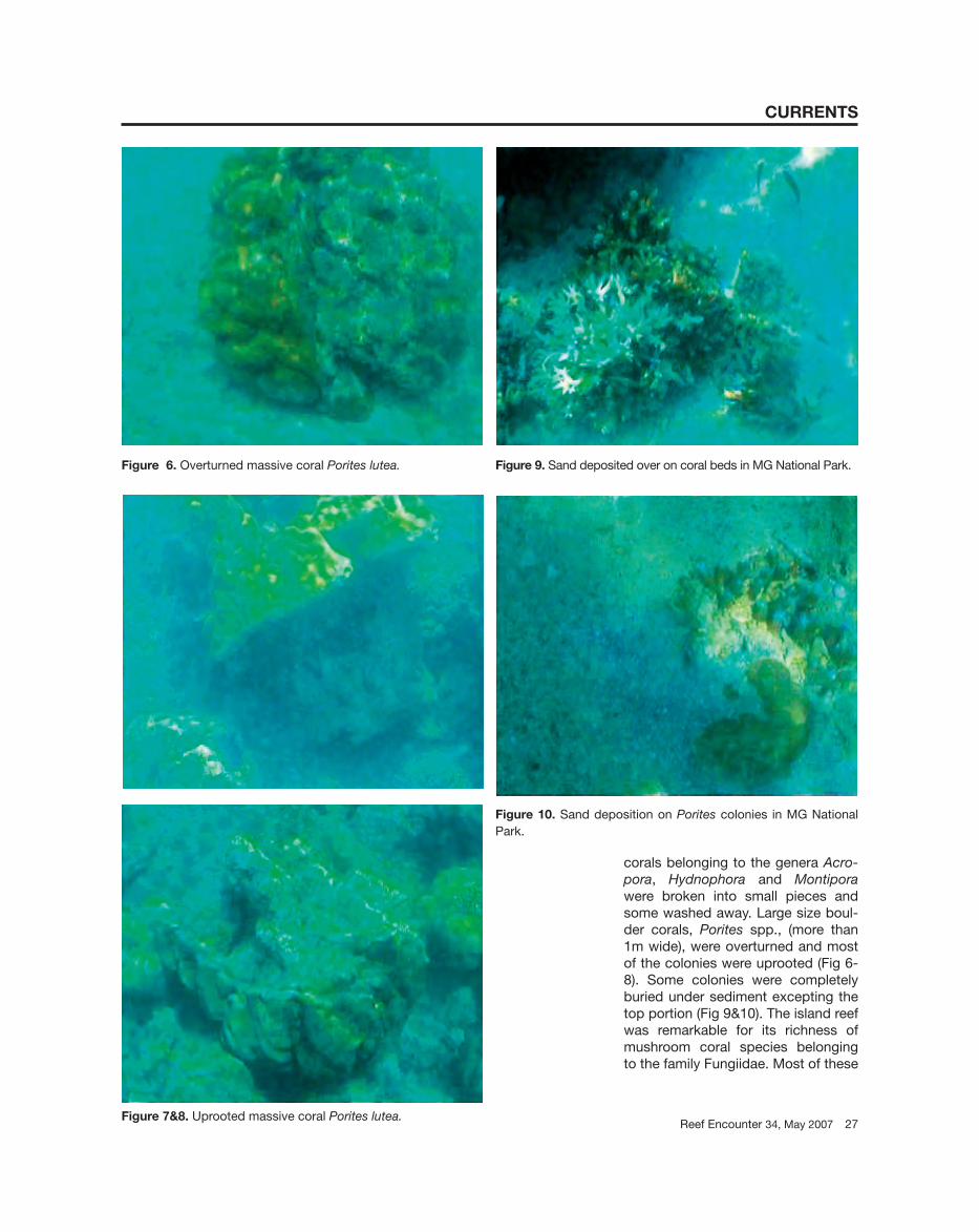
corals belonging to the genera Acro-pora, Hydnophora and Montipora were broken into small pieces and some washed away. Large size boul-der corals, Porites spp., (more than 1m wide), were overturned and most of the colonies were uprooted (Fig 6-8). Some colonies were completely buried under sediment excepting the top portion (Fig 9&10). The island reef was remarkable for its richness of mushroom coral species belonging to the family Fungiidae. Most of these
CURRENTS
Figure 6. Overturned massive coral Porites lutea.
Figure 7&8. Uprooted massive coral Porites lutea.
Figure 9. Sand deposited over on coral beds in MG National Park.
Figure 10. Sand deposition on Porites colonies in MG National Park.
specimens were washed away by the tsunami and existing live mushroom corals were suffocated by sedimenta-tion and likely result in death. The sur-vey showed 50% mortality in north-eastern reef of Jolly Buoy Island. The reef at the southwestern side was not much affected by the tsunami, and the reef slope corals were in pristine condition.
The corals around the Nicobar group of islands were extensively damaged due to heavy sand and silt deposits brought by tsunami waves. The Nicobar Islands include serpen-tine gabbros, marine deposits of the late Tertiary including sandstones, slates, clay marls and plastic clays and coral reefs of recent origin. About 6000 ha of coconut gardens were af-
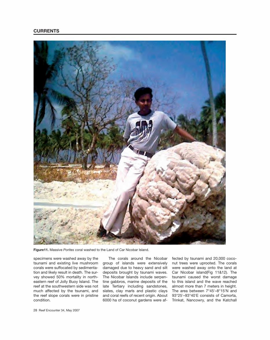
fected by tsunami and 20,000 coco-nut trees were uprooted. The corals were washed away onto the land at Car Nicobar island(Fig 11&12). The tsunami caused the worst damage to this island and the wave reached almost more than 7 meters in height. The area between 7°45ʹ–8°15ʹN and 93°25ʹ–93°40ʹE consists of Camorta, Trinkat, Nancowry, and the Katchall
CURRENTS
Figure11. Massive Porites coral washed to the Land of Car Nicobar Island.
28 Reef En coun ter 34, May 2007

Reef Encounter 34, May 2007 29
CURRENTS
Figure 12. Uprooted coconut trees along with coral fossils in Car Nicobar Island.
islands. Extensive coral reef fl ats of about 2.5 km2 occur at the northeast-ern and northwestern side of the Cam-orta Island. These reefs were severely damaged by the earthquake and tsu-nami. On the northeastern side about 2.0 km2 of landmass was eroded and all sediments were dumped onto the reef. The reef fl ats around the Trinkat Island extend up to 2.5-3.0 km2 from shore. Due to the earthquake and tsunami the island was divided into two parts. A heavy load of sediments were deposited over the reef and led to mass mortality of corals. The wind-ward reef on the northeastern side of Nancowry Island was the worst af-fected by the tsunami, resulting in a mass mortality of corals. The tsunami in the Nancowry group of islands caused extensive damage to man-
groves and 94% of mangroves were submerged. On Katchall Island alone 1550 ha, or 38% of mangroves were submerged. The coral reefs of these islands somehow played an important role in attenuating the tsunami wave height, thus lessening its destruc-tive effects. Similar phenomena were observed in the Philippines during 1992.2
Detailed coral reef survey in Great Nicobar Island showed the live coral coverage of the island was 55%.3 The coral reefs here were not affected by the bleaching event in 1998. Unlike the Andaman Island reefs, the domi-nant reef building corals in Nicobar Is-land was Acropora sp. Of the 55% live coral coverage, Acropora was 26% and the boulder coral Porites was re-stricted to 6%. The subsidence of 2-
3 meters affected the Great Nicobar Island and a maximum down throw at Indira Point (Southern most land part of India). The lighthouse on Indira point and the adjacent land are still un-der the sea. Large amount of mud and trees settled down over the reef fl ats smothering the corals. The corals in the reef fl ats of Great Nicobar Islands, particularly on the western side, were in pristine condition before the tsu-nami. These reefs are now covered by sediment.
Coral reefs of Andaman and Nicobar islands are the biodiversity hotspots of India. The post tsunami survey results showed the reduction of moray eels, sharks, triggerfi shes, boxfi shes, puffer fi shes and angel-fi shes. The coral associated fauna i.e. polychaetes, nudibranchs, fl at worms,
30 Reef En coun ter 34, May 2007
alpheid shrimps, Mantis shrimps, her-mit crabs and brachyuran crabs be-longing to the genera Trapezia, Phy-modius, Cymo and Chlorodiella were not found during the survey. Eight species of birds in the Andaman group and fi ve species of birds in the Nico-bar group of islands were reported as endemic. A small Megapode island on the western side of Great Nicobar Is-land was completely sunk under sea. This island was the habitat of the en-demic bird Megapodius nicobariensis. It builds mounds in coastal areas and, therefore, suffered from habitat de-struction and degradation before the tsunami. A mud volcano erupted on Narcondam, on June 7 2005, which had been lying dormant for nearly a century. The Barren Island, which is the only active volcano in the country, erupted once again on May 28 2005, after remaining silent for a decade. Hence, these bird species may have been severely affected by the tsunami and other subsequent changes.
Research has indicated a real danger of another earthquake in the region.4 The prediction was based on the increase of co-seismic stress on the contiguous Sunda trench subduc-tion zone and neighboring vertical
strike-slip, Sumatra fault.5 The predic-tion came true on 28 March 2005, the Sunda megathrust in Indonesia rup-tured again, producing another great earthquake three months after the previous one. An earthquake in the Sumatra fault might be expected in the near future. The Andaman & Nico-bar Islands are in earthquake prone zone 5, part of the Sumatra fault. The proposed coral reef survey in the Nicobar group of Islands by the Zoo-logical Survey of India after the mon-soon will reveal more details.
Acknowledgements
The Authors are thankful to Dr. J.R.B. Alfred, Director of the Zoological Sur-vey of India, Kolkata for constant en-couragement and excellent facilities. Thanks are also due to Chief Wildlife Warden and other staff of the Depart-ment of Environment & Forests for several courtesies.
References1Ishii, M., Shearer, P. M., Houston, H. and
Vidale, J. E. 2005. Extent, duration and speed of the 2004 Sumatra-Anda-man earthquake imaged by the Hi-Net array. Nature advance online publica-
tion; published online 22 May 2005 A| doi: 0.1038/ nature 03675
2 Besana, M.G. and Masataka, A. 2004. The May 17, 1992 event: Tsunami and coastal effects in Eastern Mindanao, Philippines. Science of Tsunami Haz-ards, 22(2): 61-68
3Jeyabaskaran, R. 1999. Report on Rapid assessment of coral reefs of Andaman & Nicobar Islands. GOI/UNDP/GEF Project on Management of Coral Reef Ecosystem of Andaman & Nicobar Is-lands. Project executed by Zoological Survey of India, Port Blair.110pp.
4Mc Closkey, J., Suleyman, S. and Nalbat, S. S. 2005. Earthquake risk from co-seismic stress: Last year Indonesian’s earthquake has increased seismic hazard in the region. Nature, 434: 291-230. published online 17 March 2005.
5Nalbant, S.S., Steacy, S., Sieh, K., Nata-widjaja, D., and McCloskey, J. 2005. Seismology: earthquake risk on the Sunda trench. Nature, 435: 756-757 published on line Jun 9, 2005.
R. Jeyabaskaran*D.V. Rao
Zoological Survey of IndiaNational Coral Reef
Research InstituteAndaman & Nicobar Regional Station
Haddo P.O, Port Blair – 744 102INDIA
*Email: [email protected]
Phenotypic plasticity in scleractinian corals is common and is generally a consequence of environmental vari-ability. These variations in skeletal morphology are normally not detri-mental to the organism’s normal func-tioning, and in some cases are the mechanism by which the animal is able to better exploit the resources of its environment (e.g., light exposure, wave energy). Additionally, altered patterns of skeletal deposition may be caused by physical injury or boring organisms, but overall are not harmful to the coral colony.
The development of tumors or neoplasia, however, can lead to the
manifestation of disease and ulti-mately cause the death of an organ-ism. These physical anomalies are caused by unnatural cellular prolifera-tion, which can be the result of the disruption of normal genetic control, either due to environmental degrada-tion or genetic predisposition. Tumors in corals were identifi ed as early as the 1960s1 and have been described in at least 10 different families2. Little is known about whether these tumors result in a disease where the function-ing of the coral is depressed. How-ever, neoplastic lesions have been described on corals belonging to the genus Acropora. These lesions are the
only identifi ed true neoplasm of corals and were described as calicoblastic epitheliomas2 because the authors ob-served the proliferation of immature, metabolically active calicoblasts, the cells that produce the exoskeleton. A neoplasm is “an abnormal tissue that grows by cellular proliferation more rapidly than normal, and continues to grow after the stimuli that initiated the new growth cease” (Stedman’s Medi-cal Dictionary, 26th Edition, 2000). Similar lesions have been reported in other coral species.3 Coral growth anomalies that appear to result from proliferation of the gastrodermal cells to form porous protuberant masses
CURRENTS
Unusual lesions and growth anomalies encountered in Acropora palmata from two sites in the tropical western Atlantic