IMAGINE Radar Mapping Suite - GEOSYSTEMS Radar Mapping Suite... · IMAGINE Radar Mapping Suite is...
7
IMAGINE Radar Mapping Suite
Transcript of IMAGINE Radar Mapping Suite - GEOSYSTEMS Radar Mapping Suite... · IMAGINE Radar Mapping Suite is...

IMAGINERadarMappingSuite
IMAGINE Radar Mapping Suite is an extensive set of tools that provide a wide range of radar-specific capabilities within the ERDAS IMAGINE® environment. IMAGINE Radar Mapping Suite’s comprehensive radar processing capabilities are further enhanced by the image processing, visualization, cartographic and GIS capabilities of the ERDAS IMAGINE product suite.
Intelligent user interfaces, wizard workflows and data-derived defaults are included throughout IMAGINE Radar Mapping Suite, ensuring user-friendly information extraction from radar imagery. These unique radar mapping tools are developed by ERDAS in cooperation with the Remote Sensing Technology Institute of the German Aerospace Center (DLR) and GEOSYSTEMS GmbH.
Supported SensorsIMAGINE Radar Mapping Suite can ingest imagery from variety of different radar sources, including Radarsat-1/2, ERS-1/2, Envisat, ALOS Palsar,TerraSAR-X and COSMO-SkyMed. For most of these sensors, a direct read capability allows visualization and evaluation of imagery without importing. In addition, a very flexible generic import capability is supplied. This enables IMAGINE Radar Mapping Suite to handle radar imagery from unsupported sources. Once ingested, the radar modules utilize scene-specific metadata to model the imaging geometry, develop intelligent processing default parameters and extract useful information products.
IMAGINE Radar Mapping SuiteRecently, we have seen the launch of a variety of second generation radar
satellites by various countries. With new data being captured, radar
applications are transitioning from research to operational, with an
increasing number of organizations recognizing the importance of radar
image processing. Radar imagery is now being utilized for a broad range
of applications, including defense and isntelligence surveillance, oil and
gas exploration, ice monitoring, agricultural and environmental monitoring,
disaster response (spills and floods) and much more. Meeting the growing
needs from radar mapping customers, ERDAS continues to enhance IMAGINE
Radar Mapping Suite.

IMAGINE Radar Mapping Suite ModulesIMAGINE Radar Mapping Suite includes IMAGINE Radar Interpreter™, IMAGINE OrthoRadar™, IMAGINE InSAR™, IMAGINE StereoSAR DEM™ and IMAGINE Coherence Change Detection™. Each module is outlined below:
IMAGINE Radar Interpreter™
IMAGINE Radar Interpreter provides fundamental tools to preprocess radar images or enhance them for visual interpretation. Because it is data source independent, IMAGINE Radar Interpreter allows you to work with any SAR imagery.
Features include:• Speckle removal • Image conversions (e.g. IQ to MP conversion)• Radiometric calibration (e.g. Beta_0 image creation)• Sensor merge with optical imagery• Slant-to-ground range conversion • Radiometric terrain correction• Texture adaptive filter and edge enhancement • Brightness adjustment
Before (above) and after (right) images of San Francisco using the IMAGINE Radar Interpreter despeckle module. The right image is a
classified vegetation map derived from Radarsat II Fine Quad-Pol data.

SPOT orthoimage (left) and radar orthoimage (right) overlay precisely.
IMAGINE OrthoRadar™
IMAGINE OrthoRadar performs precision geocoding and orthorectification of SAR images, using SAR sensor models, satellite orbit models and digital elevation models (DEMs). The resulting ortho images are highly accurate and free from the significant distortions inherent in radar imagery. Fully integrated into the ERDAS IMAGINE® environment, IMAGINE OrthoRadar easily handles GCPs, DEMs and map projections. After orthocorrection, the radar images can be used to map ground features. Because radar imagery penetrates cloud cover, perennially cloud covered areas may be mapped using orthocorrected radar images.
Features include: • Sensor model based precise orthorectification • Uses ephemeris data and advanced orbit modeling techniques • Option to use DEM to remove terrain induced image distortions • Option to use x, y, z GCPs to refine orbit model • Output to all ERDAS IMAGINE supported projections and file formats

Color-coded interferometric fringes overlain onto the radar magnitude image. Imagery from TerraSAR-X sensor.
IMAGINE InSAR™
IMAGINE InSAR applies advanced interferometric SAR processing techniques to create accurate, high-resolution DEMs from SAR image pairs. This module was developed using technology from the Remote Sensing Technology Institute of the German Aerospace Center (DLR). Exploiting the day-night and cloud penetrating capability of radar sensors, remote areas and terrain in perennially cloud covered areas can be mapped to create high precision DEMs.
Features include: • New phase unwrap algorithm co-developed with German Aerospace Center (DLR)• Option to incorporate precision state vectors for precise orbit modeling• Wizard-based workflow with intelligent, data-derived defaults • Uses scene-specific ephemeris data and advanced orbit modeling techniques • Creates accurate, detailed terrain maps; output to all ERDAS IMAGINE supported projections and file formats• Optional use of x, y, z GCPs to refine orbit model and interferometric baseline• Minimal need for GCPs to derive absolute height values• Automatically co-registers reference and match images with sub-pixel accuracy• Uses reference DEM for synthetic interferogram creation• Advanced interferogram filters• Output to all ERDAS IMAGINE supported projections and file formats

IMAGINE StereoSAR DEM™
Advanced radar sensor modeling is a unique capability of IMAGINE StereoSAR DEM. It enables ERDAS IMAGINE users to extract terrain height information from stereo pairs of RadarSAT 1/2 and TerraSAR-X to generate extremely accurate DEMs.
Features include: • Flexible hierarchical autocorrelation can be adapted to any resolution imagery; from Spotlight to ScanSAR• Stereo geometry based on true SAR imaging models• Option to incorporate precision state vectors for precise orbit modeling• Achieves accurate results without the use of ground controls• Option to use x, y, z GCPs to refine orbit model• Output to all ERDAS IMAGINE supported projections and file formats
Left, a RADARSAT Stereo-pair. Right, layover corrected RADARSAT overlain on DEM.
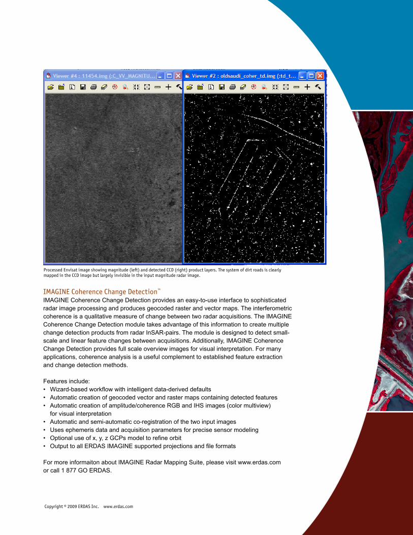
IMAGINE Coherence Change Detection™ IMAGINE Coherence Change Detection provides an easy-to-use interface to sophisticated radar image processing and produces geocoded raster and vector maps. The interferometric coherence is a qualitative measure of change between two radar acquisitions. The IMAGINE Coherence Change Detection module takes advantage of this information to create multiple change detection products from radar InSAR-pairs. The module is designed to detect small-scale and linear feature changes between acquisitions. Additionally, IMAGINE Coherence Change Detection provides full scale overview images for visual interpretation. For many applications, coherence analysis is a useful complement to established feature extraction and change detection methods.
Features include:• Wizard-based workflow with intelligent data-derived defaults• Automatic creation of geocoded vector and raster maps containing detected features• Automatic creation of amplitude/coherence RGB and IHS images (color multiview) for visual interpretation• Automatic and semi-automatic co-registration of the two input images• Uses ephemeris data and acquisition parameters for precise sensor modeling• Optional use of x, y, z GCPs model to refine orbit• Output to all ERDAS IMAGINE supported projections and file formats
For more informaiton about IMAGINE Radar Mapping Suite, please visit www.erdas.com or call 1 877 GO ERDAS.
Copyright © 2009 ERDAS Inc. www.erdas.com
Processed Envisat image showing magnitude (left) and detected CCD (right) product layers. The system of dirt roads is clearly mapped in the CCD image but largely invisible in the input magnitude radar image.