DIRECTED ORTHO METALATION – BORONATION SUZUKI-MIYAURA CROSS

Version 1.5, Effective January 2006
IKONOS® Imagery Products • Geo • Standard Ortho • Reference • Pro • Precision • PrecisionPlus • Reference Stereo • Precision Stereo

IKONOS Product Guide
i
Table of Contents
INTRODUCTION 1
PRODUCT LEVELS 1 Georectified Products ........................................ 2 Orthorectified Products...................................... 3 Stereo Products................................................. 4 Off-The-Shelf Products...................................... 5
SPECIFICATIONS 6 Spectral Range.................................................. 6 Clouds ............................................................... 6 Sun Angle .......................................................... 6 File Sizes ........................................................... 7 Support Data ..................................................... 7
OPTIONS 7 Band Combinations ........................................... 7 Horizontal Units ................................................. 8 Projections......................................................... 8 Datums .............................................................. 8 File Format ........................................................ 9 Bits/Pixel ............................................................ 9 Dynamic Range Adjust ...................................... 9 Mosaic ............................................................... 9 Resampling........................................................ 9 Media............................................................... 10
ORDERING AND DELIVERY 10 How to Order ................................................... 10 New Collections............................................... 10 Archive............................................................. 10 Minimum Order Size........................................ 10 Delivery Times................................................. 11 IKONOS Copies and Redeliveries .................. 11 Order Cancellations and Modifications............ 11
LICENSING 13 Permitted Activities .......................................... 13 Prohibited Activities ......................................... 13 License Levels................................................. 14
REGIONAL AFFILIATES 15
ABBREVIATIONS, ACRONYMS AND TERMS 17
ABOUT GEOEYE 19

IKONOS Product Guide
1
© 2006 GeoEye
Introduction When GeoEye successfully launched the IKONOS® satellite in 1999, it made history with the world’s first one-meter commercial remote sensing satellite. Since then, GeoEye has set the standard for quickly delivering large volumes of tonally balanced, map accurate, mosaicked images for a variety of industries and applications. To date, IKONOS has collected nearly 200 million square kilometers of imagery that is readily available in our digital archive.
Moving over the ground at approximately seven kilometers per second, IKONOS collects black-and-white and multispectral data at a rate of over 2,000 square kilometers per minute. IKONOS satellite imagery provides access to any location on the Earth’s surface. Through the nearly fifteen, 98-minute journeys it makes around the globe each day, IKONOS collects vital statistics about the Earth’s ever-changing features—from fluctuations in land and water resources to the build-out of new urban areas. Commercial and governmental organizations rely on GeoEye’s high-resolution imagery to view, map, measure, monitor and manage global activities. Applications range from national security and disaster assessment to urban planning and agricultural monitoring. Drawing on the spectacular views from IKONOS, the possibilities are endless.
IKONOS Facts at a Glance
Launch Date 24 September 1999 Vandenberg Air Force Base, California
Operational Life Over 8.5 Years Orbit 98.1 degree, sun synchronous Speed on Orbit 7.5 kilometers (4.7 miles) per second Speed Over the Ground 6.8 kilometers (4.2 miles) per second Number of Revolutions Around the Earth 14.7 every 24 hours Orbit Time Around the Earth 98 minutes Altitude 681 kilometers (423 miles) Resolution Nadir:
0.82 meters (2.7 feet) panchromatic 3.2 meters (10.5 feet) multispectral 26° Off-Nadir 1.0 meter (3.3 feet) panchromatic 4.0 meters (13.1 feet) multispectral
Image Swath 11.3 kilometers (7.0 miles) at nadir 13.8 kilometers (8.6 miles at 26° off-nadir)
Equator Crossing Time Nominally 10:30 a.m. solar time Revisit Time Approximately 3 days at 1-meter resolution, 40° latitude Dynamic Range 11-bits per pixel Image Bands Panchromatic, blue, green, red, near infrared
Product Levels GeoEye categorizes the imagery products gathered from IKONOS according to positional accuracy, which is determined by the reliability of an object in the image to be within the specified accuracy of the actual location of the object on the ground.
Within each IKONOS-derived product, location error is defined by a circular error at 90% confidence (CE90), which means that locations of objects are represented on the image within
IKONOS Product Guide
2
© 2006 GeoEye
the stated accuracy 90% of the time. This CE90 accuracy level can be related to Root Mean Square Error (RMSE) as well as the U.S. National Map Accuracy Standards (NMAS).
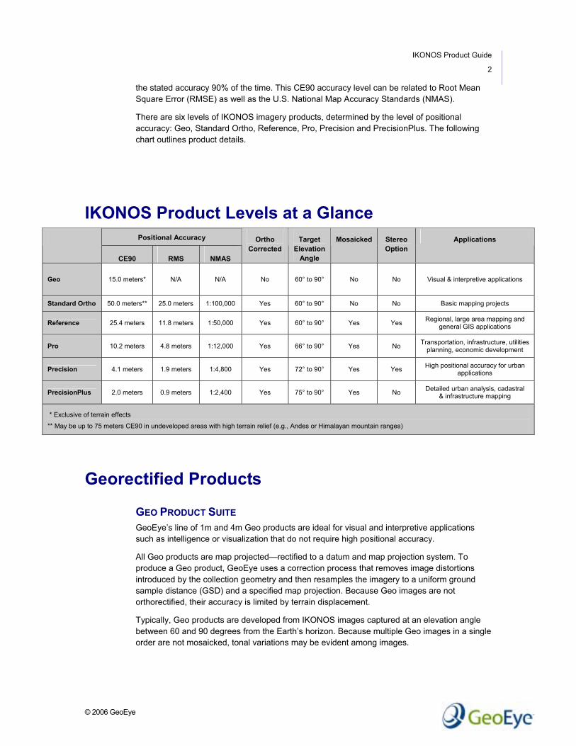
There are six levels of IKONOS imagery products, determined by the level of positional accuracy: Geo, Standard Ortho, Reference, Pro, Precision and PrecisionPlus. The following chart outlines product details.
IKONOS Product Levels at a Glance Positional Accuracy
CE90 RMS NMAS
Ortho Corrected
Target Elevation
Angle
Mosaicked Stereo Option
Applications
Geo 15.0 meters* N/A N/A No 60° to 90° No No Visual & interpretive applications
Standard Ortho 50.0 meters** 25.0 meters 1:100,000 Yes 60° to 90° No No Basic mapping projects
Reference 25.4 meters 11.8 meters 1:50,000 Yes 60° to 90° Yes Yes Regional, large area mapping and general GIS applications
Pro 10.2 meters 4.8 meters 1:12,000 Yes 66° to 90° Yes No Transportation, infrastructure, utilities planning, economic development
Precision 4.1 meters 1.9 meters 1:4,800 Yes 72° to 90° Yes Yes High positional accuracy for urban applications
PrecisionPlus 2.0 meters 0.9 meters 1:2,400 Yes 75° to 90° Yes No Detailed urban analysis, cadastral & infrastructure mapping
* Exclusive of terrain effects
** May be up to 75 meters CE90 in undeveloped areas with high terrain relief (e.g., Andes or Himalayan mountain ranges)
Georectified Products
GEO PRODUCT SUITE GeoEye’s line of 1m and 4m Geo products are ideal for visual and interpretive applications such as intelligence or visualization that do not require high positional accuracy.
All Geo products are map projected—rectified to a datum and map projection system. To produce a Geo product, GeoEye uses a correction process that removes image distortions introduced by the collection geometry and then resamples the imagery to a uniform ground sample distance (GSD) and a specified map projection. Because Geo images are not orthorectified, their accuracy is limited by terrain displacement.
Typically, Geo products are developed from IKONOS images captured at an elevation angle between 60 and 90 degrees from the Earth’s horizon. Because multiple Geo images in a single order are not mosaicked, tonal variations may be evident among images.

IKONOS Product Guide
3
© 2006 GeoEye
GEO ORTHO KIT A subset of the Geo product line, the Geo Ortho Kit is tailored for sophisticated users such as photogrammetrists who want to control the orthorectification process.
Geo Ortho Kit images include the camera geometry obtained at the time of image collection. Applying Geo Ortho Kit imagery, customers can produce their own highly accurate orthorectified products by using commercial off the shelf (COTS) software, digital elevation models (DEMs) and optional ground control.
IKONOS collects 1m and 4m Geo Ortho Kit imagery at an elevation angle between 60 and 90 degrees. To increase the positional accuracy of the final orthorectified imagery, customers can upgrade IKONOS’ elevation angle to be between 72 and 90 degrees.
Orthorectified Products
STANDARD ORTHO PRODUCT SUITE Standard Ortho is GeoEye’s entry-level orthorectified product. It is designed for basic mapping projects that are on a tight budget and need to meet the 1:100,000 National Map Accuracy Standard.
Positional accuracy of the Standard Ortho products are superior to Geo products, offered worldwide, and can be delivered in a shorter timeframe and at a lower cost to you than other orthorectified imagery.
Standard Ortho products are orthocorrected and have an accuracy of 50-meter CE90 in most locations but may be up to 75-meters in undeveloped areas with high terrain relief (e.g., Andes or Himalayan mountain ranges).
REFERENCE PRODUCT SUITE GeoEye designed 1m and 4m Reference products to be suitable for regional mapping, in addition to projects requiring an orthorectified image product with accuracy suitable for 1:50,000 mapping applications.
IKONOS collects Reference imagery at an elevation angle between 60 and 90 degrees. GeoEye orthocorrects and mosaicks all Reference-level imagery to a minimum accuracy of 25 meters CE90.
PRO PRODUCT SUITE Pro-level products are perfect for projects requiring high-resolution imagery and medium-scale accuracy when ground control may be costly, difficult or impossible to acquire.
The 1m and 4m Pro products are the most accurate, orthorectified imagery derived from IKONOS that do not require ground control. Consistent within the 10-meter CE90 accuracy level, the Pro product line provides global access to 1:12,000 NMAS imagery.
IKONOS Pro imagery is typically collected at a slightly higher elevation angle—between 66 and 90 degrees—to ensure positional accuracy.

IKONOS Product Guide
4
© 2006 GeoEye
PRECISION PRODUCT SUITE With a 1:4,800 NMAS map accuracy level, GeoEye’s Precision products support most regional and large-scale urban planning projects. IKONOS typically collects imagery for the 1m and 4m Precision products at elevation angles between 72 and 90 degrees. To increase positional accuracy, GeoEye uses ground control and high-quality elevation models for all Precision products.
PRECISIONPLUS PRODUCT SUITE PrecisionPlus, the most positionally accurate product offered by GeoEye, provides the spatial accuracy necessary for most urban planning applications, as well as cadastral and infrastructure mapping requirements.
With a two-meter CE90 accuracy, PrecisionPlus is only available in one-meter black-and-white and one-meter color. To meet these premier accuracy levels, GeoEye uses high-precision ground control and precise terrain models to create PrecisionPlus products.
Stereo Products Stereo imagery is available at one-meter resolution for the Reference and Precision accuracy levels. GeoEye provides the stereo imagery pairs with a rational polynomial coefficient (RPC) camera model file. The RPC file provides camera model data to popular software packages for photogrammetric extraction of 3D feature coordinates, digital elevation models (DEMs) and orthorectified imagery.
Each stereo pair contains an image collected at a low elevation angle (above 60 degrees) as well as an image collected at a higher elevation angle (above 72 degrees) with 30°-45° convergence (0.54 to 0.83 base-to-height ratio).
Reference Stereo products have a horizontal accuracy of 25 meters CE90 and a vertical accuracy of 22 meters LE90. Precision Stereo products have a horizontal accuracy of four meters CE90 and a vertical accuracy of five meters LE90.

IKONOS Product Guide
5
© 2006 GeoEye
Off-the-Shelf Products
1M USA GeoEye offers a 1-meter, off-the-shelf imagery product of select cities within the United States. 1m USA products are created from the highest-quality, true color IKONOS imagery, and are orthorectified to 10.2 meter CE90, mosaicked and tonally balanced. The best images for each city have already been selected, eliminating the need to search through multiple images of the same Area of Interest (AOI) to find the best image.
Using our online ordering and delivery tool, CARTERRA® Online, 1m USA products can be ordered using a credit card and delivered online. 1m USA product orders of less than 250 megabytes are readily available and can be purchased and downloaded online. After placing an order online for 1m USA, you will receive instructions by email within 24 hours (usually within 1 hour) on how to download your completed order. 1m USA products larger than 250 megabytes can be purchased online, and shipped to you on CD, DVD or hard disk. These orders will be shipped within 5 business days after an order is placed.
Because 1m USA products are already processed, they can only be ordered as 8-bit, true color GeoTIFF format files in a Geographic projection. Existing off-the-shelf products are also available for some selected cities outside of the United States.

IKONOS Product Guide
6
© 2006 GeoEye
Specifications
Spectral Range 1-meter Black-and-White Panchromatic 0.526 – 0.929 micrometers
Band 1 (blue) 0.445 – 0.516 micrometers
Band 2 (green) 0.506 – 0.595 micrometers
Band 3 (red) 0.632 – 0.698 micrometers
4-meter Multispectral or 1-meter Color
Band 4 (near infrared) 0.757 – 0.853 micrometers
For more information about the absolute radiometric calibration of the multispectral sensor, contact a GeoEye Customer Service Representative at 1.800.232.9037 (within the U.S.) or +1.301.552.0537 (internationally).
Clouds All IKONOS imagery contains less than 20% cloud cover. Customers can designate a single coordinate within the image that must be cloud free.
Sun Angle IKONOS collects imagery at an elevation angle (measured from the Earth’s surface to the sun) of greater than 15 degrees, azimuth unrestricted. Because the orbit is sun synchronous, all imagery is collected at approximately 10:30 a.m. local solar time. Therefore, all imagery has consistent sun angles.

IKONOS Product Guide
7
© 2006 GeoEye
File Sizes Use the following table to determine the file size for an IKONOS product order, according to specific color, bit, band and resolution requirements.
Bits per Pixel
Number of Bands Resolution File Size per
Square Kilometer 8 1 1-meter 1 megabyte Black & White
11 1 1-meter 2 megabyte
8 3 4-meter .1875 megabyte Multispectral (true or false color) 11 3 4-meter .375 megabyte
8 4 4-meter .25 megabyte Multispectral (4-band) 11 4 4-meter .5 megabyte
8 3 1-meter 3 megabytes Color (true or false color) 11 3 1-meter 6 megabytes
8 4 1-meter 4 megabytes Color (4-band) 11 4 1-meter 8 megabytes
8 4 1-meter + 4-meter 1.1875 megabytes Bundle (true or false color) 11 4 1-meter + 4-meter 2.375 megabytes
8 5 1-meter + 4-meter 1.25 megabytes Bundle (4-band) 11 5 1-meter + 4-meter 2.5 megabytes
Support Data All GeoEye products are shipped with a metadata file, license file and shape files. The metadata includes order parameters as well as source image and product file descriptions.
Order parameters include area of interest (AOI), spectral bands and coordinate system. Source image descriptions include acquisition date, sun angles and viewing geometry. Product file descriptions include geocoding, spectral bands and coverage area.
Metadata is provided in an ASCII text file. Shape files show order AOI, delivery component layout, and source image footprints with acquisition geometry.
Options
Band Combinations
BLACK-AND-WHITE One-meter IKONOS panchromatic imagery delivered as a single band.

IKONOS Product Guide
8
© 2006 GeoEye
MULTISPECTRAL Four-meter IKONOS imagery delivered as one file with three bands in true color (red, green, blue) or false color (near infrared, red, green); or four files of one band each (near infrared, red, green, blue).
COLOR IKONOS imagery created using a pan-sharpening process that combines one-meter spatial resolution of the panchromatic image with the spectral resolution of the multispectral bands to create a one-meter color product.
GeoEye delivers one-meter color imagery as either one file with three bands in true color (red, green, blue) or false color (near infrared, red, green); or four files of one band each (near infrared, red, green, blue).
BUNDLE When the bundle order option is selected, customers receive both one-meter black-and-white and four-meter multispectral IKONOS imagery. GeoEye delivers one-meter black-and-white imagery as a single band file. Multispectral imagery is delivered as either one file with three bands in true color (red, green, blue) or false color (near infrared, red, green); or four files of one band each (near infrared, red, green, blue).
IKONOS collects the images for a bundle order simultaneously to ensure radiometric and temporal consistency.
Horizontal Units Meters, International Feet, or U.S. Survey Feet.
Projections Choice of UTM, State Plane, Albers Conic Equal Area, Lambert Conformal Conic, or Transverse Mercator. Stereo products are also available in an epi-polar projection to facilitate stereo feature extraction applications.
Datums Choice of:
WGS84 (available worldwide) NAD83 (available in North America only) NAD27 (available in conterminous United States only)

IKONOS Product Guide
9
© 2006 GeoEye
File Format GeoEye delivers monoscopic IKONOS imagery in electronic format as an untiled GeoTIFF file or as an uncompressed NITF 2.0 file. Geo products in NITF format have a limited distribution.
Stereo imagery is available in TIFF format for epi-polar projected imagery and GeoTIFF for map-projected imagery.
Bits/Pixel GeoEye produces IKONOS imagery at either 8 or 11-bits per pixel.
Customers interested in small, easy to use images for visual interpretation should select 8-bit images. In an 8-bit image, each pixel is represented by 256 shades of gray per band.
Customers interested in full, dynamic range should select 11-bit images. When viewing an IKONOS 11-bit image, use an application that is capable of reading 16-bit file formats and adjusting both image brightness and contrast. In an 11-bit image, each pixel is represented by 2,048 shades of gray, which provides more information to discern subtle differences among objects.
Dynamic Range Adjust When ordering an IKONOS imagery product, specify whether Dynamic Range Adjust (DRA) should be “on” or “off.” If “on” is selected, GeoEye will apply DRA to enhance the visual interpretability of the image. If “off” is selected, GeoEye will maintain absolute radiometric accuracy and full dynamic range for scientific applications. The DRA option is not available for NITF file formats.
Mosaic Reference, Pro, Precision & PrecisionPlus orthorectified products ordered with DRA “on” may be mosaicked with tonal balancing. Mosaic seams will be positioned to reduce visibility. Geo, Geo Ortho Kit, and Standard Ortho products as well as products ordered with DRA “off” will not be mosaicked.
Resampling Cubic convolution (also called bi-cubic) is used by default. Nearest neighbor resampling is available on request.

IKONOS Product Guide
10
© 2006 GeoEye
Media GeoEye can deliver imagery on CD-ROM, DVD, hard drive or electronically. Electronic delivery requires system set-up and client software installation prior to delivery.
Ordering and Delivery
How to Order To order IKONOS products, contact a GeoEye Customer Service Representative at 1.800.232.9037 (within the U.S.) or +1.301.552.0537 (internationally).
Customers can purchase imagery from GeoEye for any areas of interest in the world. Customers can also purchase imagery directly from GeoEye Regional Affiliates for areas of interest within their specific communication cones. For more information on GeoEye Regional Affiliates, see Regional Affiliates on page 15 of this product guide.
New Collections New collections are orders for imagery that are not being fulfilled from GeoEye’s imagery archive and require scheduling and tasking of the IKONOS satellite. All non-standard collections such as a short-term collection window, rush delivery, etc. require a feasibility assessment and a Custom Quotation (CQ).
Archive GeoEye maintains an extensive archive of IKONOS imagery that has been collected since the launch of IKONOS in September 1999. To determine if archive imagery is available for any area of interest use GeoEye’s advanced, full featured online search tool at: http://carterraonline.spaceimaging.com
Minimum Order Size The minimum order for new collections is 100 square kilometers. For archive Geo, Geo Ortho Kit, Standard Ortho and Reference Stereo products, the minimum order size is 49 square kilometers. All other archive products have a 100-square kilometer minimum.
All orders must be a minimum of five kilometers wide in any direction.

IKONOS Product Guide
11
© 2006 GeoEye
Delivery Times Product Size Delivery Days
GeoEye North America Archive 5 business days
GeoEye Regional Affiliate Archive 10 business days
Less than 500 square kilometers (New Collection) 60 days
500 – 5,000 square kilometers (New Collection) 90 days
5,000 – 10,000 square kilometers (New Collection) 120 days
Geo Geo Ortho Kit Standard Ortho Reference Stereo
More than 10,000 square kilometers (New Collection) Custom quote
Less than 5,000 square kilometers 90 days
5,000 – 10,000 square kilometers 150 days Reference & Pro
More than 10,000 square kilometers Custom quote
Less than 5,000 square kilometers 120 days
5,000 – 10,000 square kilometers 150 days
Precision PrecisionPlus Precision Stereo
More than 10,000 square kilometers Custom quote
IKONOS Copies and Redeliveries
COPIES Additional copy of imagery requested at the time of original purchase.
REDELIVERY Additional copy of imagery requested after original data purchase.
Copy and Redelivery Minimums
Copies Geo or Stereo Redelivery Ortho Redelivery
Minimum $250.00 $250.00 $1,250
Redelivery available for licensed users only and with permission from original purchaser
Minimums apply only for SINA and Outside Communication Cones
Order Cancellations and Modifications
CANCELLATIONS Days Since the Order Date Order Conditions Cancellation Fee
Less than 3 N/A 0%

IKONOS Product Guide
12
© 2006 GeoEye
3 – 30 days N/A 25% of the order
30+ days N/A 50% of the order
N/A Late Delivery 0%
N/A Error by GeoEye 0%
MODIFICATIONS Imagery Collected? Order Conditions Fee
N/A Error by GeoEye 0%
No Order falls under cancellation policy
Ordered less than 3 days: No Fee Ordered 3 – 30 days: 25% of order Ordered 30+ days: 50% of order
Yes Cancel and reorder as desired Invoice for percent of collection completed, but if over 30 days since order date, assess a minimum of 50%

IKONOS Product Guide
13
© 2006 GeoEye
Licensing Upon sale of an image product, GeoEye retains copyright and ownership to all images we collect and produce. In effect, customers are not purchasing the image itself; rather, they are purchasing the non-exclusive right to use the image. GeoEye defines how a customer may use the image through a license. The license that is purchased by the customer also determines how much they are charged for the right to use the image. For example, a company that purchases a “Single Organization” license that only allows internal use of the data is charged less than a company that purchases a “Multiple Organization” license because they intend to share the data with another company.
Permitted Activities Under GeoEye licenses, customers may do the following.
Reformat the Product for Customer’s use into different formats or media from those in which it is delivered.
Make an unlimited number of hardcopies and softcopies of the Product for Customer’s internal use.
Distribute the Product (with copyright markings) on an isolated, non-commercial basis. For example, as part of a hardcopy research report or publication.
Modify the imagery Product, through manipulation techniques and/or the addition of other data, and make copies of the resulting bundled image product, for Customer’s internal use only.
Distribute works derived from the Product (“Derived Works”). Derived Works that contain the source image data (pixels) or reasonable facsimile of the source image data, inherit the copyright and license restrictions of the source data. Other Derived Works (vector extraction, classification, etc.) have no restrictions on use and distribution. Reduced resolution data sets (RRDS) with ratios of 16:1 or higher shall have no restrictions on use and distribution, but shall contain the copyright markings.
Make the Product available to its consultants, agents and subcontractors for purposes otherwise consistent with the Permitted Use and subject to the restrictions herein, and without the right to transfer, modify, copy or sublicense.
Post the Product and Derived Works, with copyright markings, in a non-downloadable fashion, on an Internet site with the following credit conspicuously displayed, “Includes material ©GeoEye”
Prohibited Activities GeoEye licenses prohibit the following:
Copy or reproduce (even if merged with other materials), other than as consistent with the Permitted Use.
Sell, license, transfer or disclose the Products, or use them in any manner not expressly authorized by this Agreement.

IKONOS Product Guide
14
© 2006 GeoEye
Alter or remove any copyright notice or proprietary legend contained in, or on the Products. Customer agrees that any embodiment of the Products permitted under this Agreement will contain a notice similar to the following: “Includes material © GeoEye all rights reserved.”
License Levels GeoEye’s license structure allows the customer to choose from 5 license levels.
License Price Uplift Single Organization 0% Multiple Organization 15% Tier 1 30% Tier 2 55% Tier 3 90%
SINGLE / MULTIPLE ORGANIZATION LICENSE The Single Organization license allows customers to use the data at one of the following narrowly Defined Customer Groups. The multiple organization license allows the customer to select two of these narrowly defined customer groups.
One private individual
One company or corporation, but not subsidiaries
One civilian federal agency below the U.S. Cabinet level
One of the four branches of the military, a defense agency, one of the unified commands, one of the non-DoD entities identified in the Title 50 USC 401a or the State Department (U.S. A.I.D. shall not be considered to be a component of the State Department)
One state or provincial agency
All departments of one county government
All departments of one city government
One Non Governmental Organization (NGO) or Non-Profit Organization (NPO)
All departments within a single educational organization within a single country
TIER LICENSE A “Tier 1” license allows the data to be used by one more Broadly Defined Customer Groups. A “Tier 2” allows data to be shared by two of the following customer groups. A “Tier 3” license allows data to be used by all customer groups.
Multiple private companies and/or corporations to include subsidiaries
All Federal Civilian Government Agencies of a single country
All DoD/Title 50 Government Agencies of a single country. Includes all Title 50 organizations as defined in 50 USC 401a in the United States.

IKONOS Product Guide
15
© 2006 GeoEye
One of the four branches of the military, a defense agency, one of the unified commands, one of the non-DoD entities identified in the Title 50 USC 401a or the State Department (U.S. A.I.D. shall not be considered to be a component of the State Department); and “Coalition Forces" including the foreign Department/Ministry of Defense (DoD/MoD) and intelligence organizations, as well as headquarters elements of the UN, NATO, and similar coalitions.
All state or provincial government agencies of a single state or province
All local municipal government agencies (county and city) of a single municipality
Multiple Non Governmental Organizations (NGO) and/or Non-Profit Organizations (NPO)
All departments within a single educational organization within a single country
Multiple International Agencies (such as the U.N.) and host nations
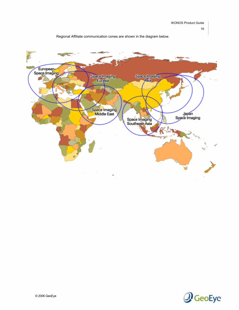
Regional Affiliates GeoEye maintains a network of Regional Affiliates (RA) who are involved in collecting, processing, marketing and distributing imagery products based on GeoEye’s IKONOS satellite.
The Regional Affiliate network provides the operating framework for streamlining commercial operations and procedures on a worldwide basis. It also standardizes order management processes across all RAs, to ensure the best customer service experience in the industry. The Regional Affiliate program maximizes direct access to the IKONOS satellite, thereby increasing commercial order fulfillment capacity.
The Regional Affiliates include:
Japan Space Imaging Tokyo, Japan
INTA Spaceturk Ankara, Turkey
WIA Corporation Seoul, Korea
Space Imaging Middle East Dubai, United Arab Emirates
European Space Imaging Munich, Germany
Space Imaging SouthEast Asia Bangkok, Thailand
GeoEye’s CARTERRA® Online (http://carterraonline.spaceimaging.com) allows customers worldwide to have instant access to all Regional Affiliate IKONOS data archives.
Customers located within any of the RAs’ communications cones are encouraged to deal directly with the RA closest to their location or an authorized local GeoEye Reseller. Customers outside of any of the communications cones may deal directly with any RA or Reseller. GeoEye’s exclusive sales territory includes Canada, the United States, Mexico and the Caribbean.
IKONOS Product Guide
16
© 2006 GeoEye
Regional Affiliate communication cones are shown in the diagram below.

IKONOS Product Guide
17
© 2006 GeoEye
Abbreviations, Acronyms and Terms AOI Area of Interest.
B/H Base-to-height ratio of a stereo pair.
Black-and-white Single band, black-and-white imagery. Also referred to as panchromatic.
CE90 Circular Error 90. Indicates that the actual location of an object is represented on the image within the stated accuracy 90% of the time.
color Imagery derived by fusing black-and-white and multispectral imagery.
COTS Commercial Off The Shelf.
DEM Digital Elevation Model.
DRA Dynamic Range Adjust. An optional post-processing feature that enhances the visual interpretability of the image.
DTM Digital Terrain Model.
false color Viewing multispectral or color imagery in a specific combination of bands (near infrared, red, green). When viewing false color imagery, colors appear “abnormal” (e.g., healthy, green vegetation appears in red on a false color image). False color imagery is commonly used in vegetation analysis.
GSD Ground Sample Distance. The size of a single pixel as measured on the ground.
IGM Image Geometry Model. Also referred to as Rational Polynomial Coefficients (RPC).
LE90 Linear Error 90. Indicates that the actual elevation of an object is represented on the image within the stated accuracy 90% of the time.
monoscopic The collection of a single image, as opposed to a stereo collection.
mosaic The process of digitally assembling images to create contiguous large-area coverage.

IKONOS Product Guide
18
© 2006 GeoEye
ABBREVIATIONS, ACRONYMS AND TERMS (CONTINUED)
multispectral Imagery collected by IKONOS in two or more ranges of wavelengths in the electromagnetic spectrum.
nadir The point on the ground vertically beneath the sensor.
NMAS United States National Map Accuracy Standards.
orthorectification The process of removing image distortions introduced by the collection geometry and variable terrain, and re-sampling the imagery to a specified map projection. Also referred to as orthocorrection.
RA GeoEye Regional Affiliate. The current GeoEye Regional Affiliates are Japan GeoEye, GeoEye Asia, European GeoEye, GeoEye Eurasia, GeoEye Middle East, and GeoEye Southeast Asia.
RMSE Root Mean Square Error.
RPC Rational Polynomial Coefficient camera model. RPCs provide the camera geometry obtained at the time of the image collection. Commercial Off the Shelf (COTS) software can utilize RPC to allow photogrammetric processing.
stereo The collection of two or more images of the same Area of Interest (AOI) from different viewing angles.
true color Viewing multispectral or color imagery in a specific band combination (red, green, blue). When viewing true color imagery, colors appear “normal” (e.g., vegetation is green).

IKONOS Product Guide
19
© 2006 GeoEye
About GeoEye GeoEye is the leading supplier of visual and geographic information products and related services.
For detailed product information, or to learn more about how GeoEye can add value to your organization, visit our website at www.geoeye.com; or call us at 1.800.232.9037 or +1.301.552.0537.
GeoEye 21700 Atlantic Blvd Dulles, Virginia 20166 www.geoeye.com
U.S.A.: 703.480.7500 International: +1.703.480.7500
© GeoEye. All rights reserved. All registered trademarks, pending trademarks, or service marks are property of their respective owners.
THIS PUBLICATION IS PROVIDED "AS IS" WITHOUT WARRANTY OF ANY KIND, EITHER EXPRESS OR IMPLIED, INCLUDING, BUT NOT LIMITED TO, THE IMPLIED WARRANTIES OF MERCHANTABILITY, FITNESS FOR A PARTICULAR PURPOSE, OR NON-INFRINGEMENT.
THIS PUBLICATION COULD INCLUDE TECHNICAL INACCURACIES OR TYPOGRAPHICAL ERRORS. CHANGES ARE PERIODICALLY ADDED TO THE INFORMATION HEREIN; THESE CHANGES WILL BE INCORPORATED IN NEW EDITIONS OF THE PUBLICATION. GEOEYE MAY MAKE IMPROVEMENTS AND/OR CHANGES TO THE PRODUCT(S) AND/OR THE PROGRAM(S) DESCRIBED IN THIS PUBLICATION AT ANY TIME.
IKONOS Product Guide Prepared by GeoEye January, 2006 Version 1.5