IJMRD 2015; 2(2): 411-419 Colonialism and urban primacy in ...
9
~ 411 ~ IJMRD 2015; 2(2): 411-419 www.allsubjectjournal.com Impact factor: 3.672 Received: 03-02-2015 Accepted: 17-02-2015 E-ISSN: 2349-4182 P-ISSN: 2349-5979 Taruna Bansal Assistant Professor, Department of Geography, Jamia Millia Islamia, New Delhi, India; Awadh Narayan Choubey Research Scholar, Department of Geography, Jamia Millia Islamia, New Delhi, India; Correspondence: Taruna Bansal Assistant Professor, Department of Geography, Jamia Millia Islamia, New Delhi, India; Colonialism and urban primacy in the Punjab region (1901 – 1951) Taruna Bansal, Awadh Narayan Choubey Abstract Even though large number of anthropologists have paid attention to the process of urbanisation very few of them have entertained the idea that high urban primacy or lack thereof, is a social pattern which influences the cultural values, politics and social behaviour of a region in the wider context. While analysing the process of urbanization one usually notes the existence of three types of city size distribution. These are central place, rank size and primate city distributions. This paper is primarily concerned with the last two. Rank size distribution is important as it is indicative of political unity and an integrated urban system while primate city – size distribution indicates if there is any imbalance in the distribution of cities. Moreover it is a useful tool for the analysis of the decline and growth of individual cities, of a class of cities and of the entire group of cities in a given region. In the above background, the present paper addresses the question of city-size distribution in colonial Punjab from 1901 to 1941. Due to the paucity of data the area of study is restricted to the state of Punjab after Independence. Although an overview of the province of Punjab will be sited. In the first section the paper discusses the theoretical bases of the paper followed by the methodology. In the second section the temporal analysis of the city-size distribution in Punjab will be analysed and in the third section the rank-size distribution and urban primacy will be analysed. The last section will critically analyse the urban system that evolved in Punjab under the last phase of British rule with conclusions drawn from the study. Keywords: Colonial Urbanisation, Historical Geography, City-size, Urban Primacy 1. Introduction Studies on urbanisation and urban centres during the colonial period have largely remained a relatively less explored field. As a result some of the works on urbanisation are nothing more than compilations of lists of towns under various categories such as market, trade and commercial centres, political and administrative centres and religious centres. 1 Sociologists look at it a as a process of modernisation and social change – a breakdown of traditional social institutions and values; geographers look at urbanisation from two perspectives – the first is the enormous absolute increase in the numbers of people living in urban areas, simply termed a urban growth and the second aspect is the relative shift of population from the countryside to the towns referred as urbanization; whereas economists emphasizes on urban centres as engines of economic growth. Urban growth and urbanization are caused by a number of factors, often complex. Briggs (1968) suggested that one of the interesting tasks of an urban historian is ‘to show in what respects cities differed from each other’. This is more fascinating in the case of India as the number of towns has increased almost continuously since the sixth century B.C in India. During this long period the dominant economic and political forces of the day have left a distinctive mark on the towns in terms of urban organisation and structure. i The establishment of the British rule brought fundamental economic transition in India, transforming agriculture from subsistence to commercial with the introduction of cultivation of variety of new crops such as tobacco, groundnuts, indigo, jute, tea, coffee etc. and gradual mechanised industrialization of the economy. The development of transport and foreign trade paved the way for new systems in urbanisation in India. Even though large number of anthropologists have paid attention to the process of urbanisation very few of them have entertained the idea that high urban primacy or lack thereof, is a social pattern which influences the cultural values, politics and social behaviour of a region in the wider context. While analysing the process of urbanization one usually International Journal of Multidisciplinary Research and Development 2015; 2(2): 411-419
Transcript of IJMRD 2015; 2(2): 411-419 Colonialism and urban primacy in ...

~ 411 ~
IJMRD 2015; 2(2): 411-419 www.allsubjectjournal.com Impact factor: 3.672 Received: 03-02-2015 Accepted: 17-02-2015 E-ISSN: 2349-4182 P-ISSN: 2349-5979 Taruna Bansal Assistant Professor, Department of Geography, Jamia Millia Islamia, New Delhi, India; Awadh Narayan Choubey Research Scholar, Department of Geography, Jamia Millia Islamia, New Delhi, India; Correspondence: Taruna Bansal Assistant Professor, Department of Geography, Jamia Millia Islamia, New Delhi, India;
Colonialism and urban primacy in the Punjab region
(1901 – 1951) Taruna Bansal, Awadh Narayan Choubey Abstract Even though large number of anthropologists have paid attention to the process of urbanisation very few of them have entertained the idea that high urban primacy or lack thereof, is a social pattern which influences the cultural values, politics and social behaviour of a region in the wider context. While analysing the process of urbanization one usually notes the existence of three types of city size distribution. These are central place, rank size and primate city distributions. This paper is primarily concerned with the last two. Rank size distribution is important as it is indicative of political unity and an integrated urban system while primate city – size distribution indicates if there is any imbalance in the distribution of cities. Moreover it is a useful tool for the analysis of the decline and growth of individual cities, of a class of cities and of the entire group of cities in a given region. In the above background, the present paper addresses the question of city-size distribution in colonial Punjab from 1901 to 1941. Due to the paucity of data the area of study is restricted to the state of Punjab after Independence. Although an overview of the province of Punjab will be sited. In the first section the paper discusses the theoretical bases of the paper followed by the methodology. In the second section the temporal analysis of the city-size distribution in Punjab will be analysed and in the third section the rank-size distribution and urban primacy will be analysed. The last section will critically analyse the urban system that evolved in Punjab under the last phase of British rule with conclusions drawn from the study.
Keywords: Colonial Urbanisation, Historical Geography, City-size, Urban Primacy
1. Introduction Studies on urbanisation and urban centres during the colonial period have largely remained a relatively less explored field. As a result some of the works on urbanisation are nothing more than compilations of lists of towns under various categories such as market, trade and commercial centres, political and administrative centres and religious centres.1 Sociologists look at it a as a process of modernisation and social change – a breakdown of traditional social institutions and values; geographers look at urbanisation from two perspectives – the first is the enormous absolute increase in the numbers of people living in urban areas, simply termed a urban growth and the second aspect is the relative shift of population from the countryside to the towns referred as urbanization; whereas economists emphasizes on urban centres as engines of economic growth. Urban growth and urbanization are caused by a number of factors, often complex. Briggs (1968) suggested that one of the interesting tasks of an urban historian is ‘to show in what respects cities differed from each other’. This is more fascinating in the case of India as the number of towns has increased almost continuously since the sixth century B.C in India. During this long period the dominant economic and political forces of the day have left a distinctive mark on the towns in terms of urban organisation and structure.i The establishment of the British rule brought fundamental economic transition in India, transforming agriculture from subsistence to commercial with the introduction of cultivation of variety of new crops such as tobacco, groundnuts, indigo, jute, tea, coffee etc. and gradual mechanised industrialization of the economy. The development of transport and foreign trade paved the way for new systems in urbanisation in India. Even though large number of anthropologists have paid attention to the process of urbanisation very few of them have entertained the idea that high urban primacy or lack thereof, is a social pattern which influences the cultural values, politics and social behaviour of a region in the wider context. While analysing the process of urbanization one usually
International Journal of Multidisciplinary Research and Development 2015; 2(2): 411-419

~ 412 ~
International Journal of Multidisciplinary Research and Development
notes the existence of three types of city size distribution. These are central place, rank size and primate city distributions. This paper is primarily concerned with the last two. Rank size distribution is important as it is indicative of political unity and an integrated urban system while primate city – size distribution indicates if there is any imbalance in the distribution of cities. Moreover it is a useful tool for the analysis of the decline and growth of individual cities, of a class of cities and of the entire group of cities in a given region. In the above background the paper analyzes the pattern of urbanization in colonial Punjab. The contours of administrative map of Punjab have undergone extraordinary changes in the past. The nomenclature ‘Punjab’ was widely used during the reign of Akbar (A.D. 1556-1605). It was
known as the Kingdom of Lahore during the reign of Maharaja Ranjit Singh (1700-1839). The British occupied it in 1849 and merged Delhi and the Hissar division of the former Northwest Province (now Uttar Pradesh) with Punjab in 1858. In 1901, Punjab’s border districts situated across the Indus were taken away to form the Northwest Frontier Province. Subsequently, Delhi was separated from Punjab. At the time of the partition of the India sub-continent in 1947, Punjab was bifurcated into two parts: West Punjab (Pakistan) and East Punjab (India). Colonial Punjab consisted of five administrative divisions – Delhi, Lahore, Jullandhar, Multan and Rawalpindi and princely states like Bahawalpur, Jind, Patiala, Chamba, Kapurthala, Bahahr and so on (Map 1).
Map 1
Map 2
After partition in 1947, 14 districts and 18 princely states became part of Punjab in India (Map 2 and 3). Due to the paucity of data the area of study is restricted to the state of
Punjab after Independence although the analysis has been done for the period 1901-1951.

~ 413 ~
International Journal of Multidisciplinary Research and Development
Map 3 The paper is divided into four sections to investigate the process of urbanisation experienced by the Indian Punjab during the last phase of the colonial rule. In the materials and methods section the paper is divided into three segments. In the first segment level and degree of urbanisation has been identified on the basis of Census data collected from 1901 to 1951. In the second segment the urban morphology (class – size distribution of towns) has been analysed. The third segment discusses the development of primacy. Each of these measures has been calculated for the region under investigation. The study is based on time series analysis of 213 towns in the Indian Punjab for five decades between 1901 and 1951. Conclusions form the last part of the paper. Materials and Methods 1.1 Level and Degree of Urbanization The colonial phase of Punjab, the land of five rivers, was marked by number of changes in its demographic scene. During this period the region witnessed reorganisation of the administrative space, reclamation of vast stretches of wetlands by laying out an extensive network of canal irrigation and construction of railways rendering connectivity not only within the region but also with the port cities of Calcutta, Bombay and Karachi in particular.ii This phase is important to study as the urban structure in post-independence Punjab has been inherited from the colonial period, though it is relatively balanced compared to other statesiii in spite of demographic upheavals witnessed by the
state. To understand the trend the level of urbanization has been computed for Colonial Punjab from 1901 to 1951 (Table 1). The data in the table shows that during the last phase of colonial rule Punjab experienced steady increase in its urban population except in 1901-11. The figures increase from 13.39 per cent in 1901 to 31.10 per cent in 1951. This trend is more evident when one examines the decadal variation in the urban population.
Table 1 Level of Urbanisation in Punjab (India) (1901-1951)
Census Years Level of Urbanization
1901 13.39
1911 13.26
1921 14.13
1931 17.16
1941 20.86
1951 31.10
Source: Census of India, 1951 Table 2 Per Cent Decadal Variation of Urban Population in Punjab
(I) (1901-1951)
Census Years Per Cent Decadal Variation of Urban Population
1901-11 -9.58 1911-21 10.61 1921-31 30.36 1931-41 39.65 1941-51 44.36
Source: Census of India, 1951
The data in table 2 shows decadal variation in percentage as experienced by colonial Punjab from 1901-11 to 1941-51. The data clearly shows that the urban population in the state has shown a continuous increase throughout this period. This increasing trend can be further explained through the concept of degree of urbanisation as it will explain the demographic process of urbanisation experienced by this region. The degree of urbanization is defined as relative number of people living in urban areas. Percent urban [(U/P)*100] and percent rural [(R/P)*100] and urban-rural ratio [(U/R)*100] are used to measure degree of urbanisation. These are most commonly used for measuring degree of urbanization. The index is 0 for total population equal to rural population. When whole population is urban, this index is one. When 50 percent of the population is rural, it means that there is one urbanite for each rural person. From the data in table 3 and figure 1 it is clear that percent urban has increased from 11.81 per cent in 1901 to 23.72 per cent in 1951, whereas percent rural has shown gradual decrease from 88.19 per cent to 76.28 per cent. Urban rural ratio a simple index measuring number of urbanites for each rural person in an areal unit is an important indicator in the process of urbanization. Here it indicates that in 1901 there were around 13 urbanities against every 100 ruralites which increased to 31 in 1951.

~ 414 ~
International Journal of Multidisciplinary Research and Development
Table 3 Degree of Urbanisation in Punjab - India (1901-1951)
Census Years Per cent Urban Per Cent Rural Urban –Rural Ratio (Per Cent) 1901 11.81 88.19 13.39 1911 11.71 88.29 13.26 1921 12.38 87.62 14.13 1931 14.64 85.36 17.16 1941 17.26 82.74 20.86 1951 23.72 76.28 31.10
Source: Census of India, 1951
Fig 1 Degree of Urbanisation in Punjab - India (1901-1951)
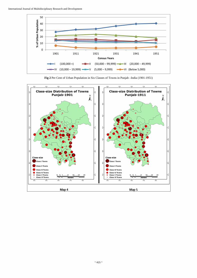
1.2 Urban Morphology The lop-sided urbanization existing in present – day India is a legacy of the colonial regime. India’s urbanisation is characterized by continuous concentration of population and activities in large cities.iv This is manifested in a high percentage of urban population being concentrated in class I
cities and is evident from the data in table 5 and figure 5. The data shows that in 1901 the percentage of class I cities was 27.44 per cent which gradually increased to 39.84 per cent in 1941and 40.68 per cent in 1951. Class II towns have shown insignificant increase over the period.
Table 5 Per Cent of Urban Population in Six Classes of Towns in Colonial Punjab
(1901-1951)
Class of Towns No. of Towns 1901 1911 1921 1931 1941 1951
I (100,000 +) 05 27.44 31.07 32.14 36.52 39.84 40.68
II (50,000 – 99,999) 10 15.34 16.20 15.98 14.24 12.93 15.42
III (20,000 – 49,999) 27 21.82 22.67 23.91 22.42 20.52 18.18
IV (10,000 – 19,999) 36 14.04 14.13 13.65 12.53 11.84 10.76
V (5,000 – 9,999) 64 14.92 12.53 11.82 11.53 11.99 10.32
VI (Below 5,000) 71 6.44 3.40 2.50 2.76 2.88 4.64
Total 213 100.0 100.0 100.0 100.0 100.0 100.0
Source: Census of India, 1951
On the contrary the class III, IV and V cities have shown declining trends. This is because the growth rates of bigger towns vis a vis class I towns is often higher than those of the lower order towns, the growth of the latter being determined
by that of the regional economy.v The decennial growth rate of cities in each size class is evident from the maps presented here (Maps 4-9).
0
20
40
60
80
100
1901 1911 1921 1931 1941 1951
In Percentage
Census Years
Per cent Urban Per Cent Rural Urban –Rural Ratio (Per Cent)
~ 415 ~
International Journal of Multidisciplinary Research and Development
Fig 2 Per Cent of Urban Population in Six Classes of Towns in Punjab –India (1901-1951)
0
10
20
30
40
50
1901 1911 1921 1931 1941 1951
% of Urban
Population
Census Years
I (100,000 +) II (50,000 – 99,999) III (20,000 – 49,999)
IV (10,000 – 19,999) V (5,000 – 9,999) VI (Below 5,000)

~ 416 ~
International Journal of Multidisciplinary Research and Development
1.3 Development of Primacy The indices of urbanisation discussed above are also indicated by the measure of the primacy. Urbanisation in colonial India was characterised by the existence of high degree of primacy, that is, the relationship of the largest city
of the region to the smaller urban centres in the hinterland.vi This was accompanied by an absence of formal urban systems with regional core areas of higher growth, surrounded by urban areas with lower growth. The point may be illustrated with reference to the spatial pattern in

~ 417 ~
International Journal of Multidisciplinary Research and Development
industrially developed countries like the United States and Britain during the late nineteenth century.vii During the colonial period a pattern characterised by the emergence of only a few dominant cores emerged. At the
same time primate city did not develop in the region. The phenomenon is evident from the Zipf’s rank size rule plotted for each census for all the 214 cities within the region (Figure 3 -8).
Fig 3: Rank Size of Cities of the Punjab Region - 1901
Fig 4: Rank Size of Cities of the Punjab Region - 1911
Fig 5; Rank Size of Cities of the Punjab Region – 1921

~ 418 ~
International Journal of Multidisciplinary Research and Development
Fig 6: Rank Size of Cities of the Punjab Region - 1931
Fig 7: Rank Size of Cities of the Punjab Region – 1941
Fig 8: Rank Size of Cities of the Punjab Region - 1951
For further explanation the Three-city Index of Urban Primacy has been calculated. This compares the size of the largest city with the combined sizes of the next two largest cities of the region. Thus, if city X is 100, Y is 25 and Z is 15, the UPI = Y + Z/ X *100. This index has been used to understand the wide cross-cultural nature of the primacy and its unexplained variability which clearly suggests the
existence of special cultural relationships, processes and values within the region (Table 7). Table 7: Index of Urban Primacy in the Punjab Region (1901 1951)
Census Years Index of Urban Primacy
1901 105.01
1911 90.82
1921 88.34

~ 419 ~
International Journal of Multidisciplinary Research and Development
1931 97.58
1941 96.32
1951 65.81
Conclusions In this paper an effort has been made to establish a framework within which the specific phenomenon of colonial urbanisation in the twentieth century can be analysed. Using this framework for the study of urbanisation in the Punjab region has been attempted for the period 1901-1951. In terms of spatial patterns, colonial urbanisation replaced the medieval urban structure which had several sub – systems with a pattern of primacy (regional primates developed). Secondly, towns of all classes existed on a continuous basis for the entire period under study. This feature is the representation of the urban processes Punjab witnessed over the centuries forming the backbone of the regional urban system. Thirdly, the hierarchy once established maintained itself over the period and proves relent in diverse politico-economic situations. In other words one can conclude that the urbanization pattern of Punjab was a collage of several localized factors.
References 1. V. Mallikaarjuna Reddy (2014) Urbanisation in India
During Colonial Rule and Historiography: Prospective and Problems, Indian Journal of Research- Paripex, Vol. 3, No. 2, pp. 130.
2. R. W. Bradnock (1984) Urbanization in India: Case in the Developing World, John Murray Ltd, London, pp.23.
3. G. Krishan (2004) Demography of the Punjab (1849 – 1947), Journal of Punjab Studies, Spring, Vol. 11, No. 1, pp. 77.
4. K. C. Sivaramakrishnan, A. Kundu and B. N. Singh (2005) Handbook of Urbanization in India: An Analysis of Trends and Processes, Oxford University Press, New Delhi, pp. 121.
5. A. Kundu (1983) "Theories of City Size Distribution and Indian Urban Structure – A Reappraisal", Economic and Political Weekly, Vol. 18, No. 3, p. 1364.
6. Ibid 7. P. L. Doughty (1979) A Latin American Speciality in the
World Context: Urban Primacy and Cultural Colonialism in Peru,Urban Anthropology, Vol 8, No. 3 / 4, pp.383.
8. Op. Cit 2, p. 165 -66.