II.2. BOWIE - THC.Texas.Gov · Sanborn fire insurance maps offer the most complete and thorough...
16
THE MERIDIAN HIGHWAY Case Studies | Bowie, Texas II.2. BOWIE Bowie Brings Back By‐Gone Bliss “Down the Road we bowl towards Bowie. Historic name, and what floods of musings and memories are aroused thereby. And we cannot help but pause and recite the fact that it is well‐named, and we again recall the glorious history of Bowie, and Travis, and Crockett, and the kindred spirits who so patriotically sacrificed themselves at the Alamo at San Antonio, that Texas might forever be the home of the brave and free. Bowie has a population of 4,000 and is the center of a rich country.” G. A. MacNaughton, The Meridian Road in Texas, 1916 The community of Bowie in Montague County is important to the Meridian Highway because it marks the northernmost location in Texas where the general path of the highway has remained the same over time. As originally conceived and promoted, the Meridian Road entered Texas near Burkburnett and continued on to Wichita Falls, Henrietta, Bowie, and beyond. In fact, an early promotional map that depicted the concept of the Meridian Highway noted Bowie as one of the cities in Texas along its path (Figure 95, to follow). This route later became part of the original State Highway No. 2, as designated by the Texas Highway Commission with the establishment of the original state highway network in 1917. The Texas Highway Commission also dubbed the route as the Meridian Highway in Texas. The construction of a new toll bridge over the Red River near Ringgold led to the development of an alternate route to Bowie, which gained popularity over time. By 1922, the Texas Highway Commission absorbed this segment into the state highway system and designated it as part of SH 2. The establishment of the federal highway numbering system in 1926 led to several profound changes that affected the Meridian Highway but Bowie remained a key location on the route. Most of the Meridian Highway was designated as US 81, which included the Ringgold–Bowie leg. The Wichita Falls– Henrietta–Bowie segment became part of US 370 (later US 287); however, both routes followed the same southeastward path from Bowie as the highway continued on to Decatur and Fort Worth and beyond. This route generally paralleled the Fort Worth and Denver City Railway. Thus, Bowie evolved into an important crossroads within the state highway network between Wichita Falls and Fort Worth. At the time of the establishment of the Meridian Road in 1911, Bowie was an important commercial and trade center in southwestern Montague County. The community was founded in 1882 when the FW&DC Railway extended its line through the area and was named for James Bowie, who died at the Alamo fighting for Texas’s independence. In 1893, the Chicago, Rock Island and Texas Railway established service Page 163
Transcript of II.2. BOWIE - THC.Texas.Gov · Sanborn fire insurance maps offer the most complete and thorough...

THE MERIDIAN HIGHWAY
Case Studies | Bowie, Texas
II.2. BOWIE
Bowie Brings Back By‐Gone Bliss
“Down the Road we bowl towards Bowie. Historic name, and what floods of musings and memories are aroused thereby. And we cannot help but pause and recite the fact that it is well‐named, and we again recall the glorious history of Bowie, and Travis, and Crockett, and the kindred spirits who so patriotically sacrificed themselves at the Alamo at San Antonio, that Texas might forever be the home of the brave and free. Bowie has a population of 4,000 and is the center of a rich country.”
G. A. MacNaughton, The Meridian Road in Texas, 1916
The community of Bowie in Montague County is important to the Meridian Highway because it marks the northernmost location in Texas where the general path of the highway has remained the same over time. As originally conceived and promoted, the Meridian Road entered Texas near Burkburnett and continued on to Wichita Falls, Henrietta, Bowie, and beyond. In fact, an early promotional map that depicted the concept of the Meridian Highway noted Bowie as one of the cities in Texas along its path (Figure 95, to follow). This route later became part of the original State Highway No. 2, as designated by the Texas Highway Commission with the establishment of the original state highway network in 1917. The Texas Highway Commission also dubbed the route as the Meridian Highway in Texas. The construction of a new toll bridge over the Red River near Ringgold led to the development of an alternate route to Bowie, which gained popularity over time. By 1922, the Texas Highway Commission absorbed this segment into the state highway system and designated it as part of SH 2. The establishment of the federal highway numbering system in 1926 led to several profound changes that affected the Meridian Highway but Bowie remained a key location on the route. Most of the Meridian Highway was designated as US 81, which included the Ringgold–Bowie leg. The Wichita Falls–Henrietta–Bowie segment became part of US 370 (later US 287); however, both routes followed the same southeastward path from Bowie as the highway continued on to Decatur and Fort Worth and beyond. This route generally paralleled the Fort Worth and Denver City Railway. Thus, Bowie evolved into an important crossroads within the state highway network between Wichita Falls and Fort Worth.
At the time of the establishment of the Meridian Road in 1911, Bowie was an important commercial and trade center in southwestern Montague County. The community was founded in 1882 when the FW&DC Railway extended its line through the area and was named for James Bowie, who died at the Alamo fighting for Texas’s independence. In 1893, the Chicago, Rock Island and Texas Railway established service
Page 163

THE MERIDIAN HIGHWAY
Case Studies | Bowie, Texas
Figure 95. The Meridian Road, no date. This map was used to promote the Meridian Road following the establishment of the Meridian Road Association in 1911. Although it lacks specificity and scale, the map identifies cities along the route. Among those cities listed in Texas included Bowie, which implies a sense of importance for motorists traveling the highway. Source: Birmingham Public Library, Birmingham, Alabama.
Page 164

THE MERIDIAN HIGHWAY
Case Studies | Bowie, Texas
through western Montague County and crossed the FW&DC Railway just west of Bowie. The city’s location at the juncture of two major railroads boosted the local economy and enabled local agriculturists to ship their goods to more distant markets. Cotton was the most profitable agricultural commodity, as evidenced by the number of cotton gins, compresses, and cotton yards in the city. The two railroads also played an important role in the establishment of early automobile routes during the 1910s when so many of the routes paralleled existing rail lines.
One of the most striking aspects of Bowie is its layout and the many odd‐sized blocks and intersections, especially in the downtown area (see Figure 96, to follow). These features affected how the Meridian Highway extended through the city and how and where local entrepreneurs established roadside‐related businesses along the route. The retail district developed on the north side of the FW&DC tracks, primarily along Smythe, Tarrant, Wise, and Mason streets. Most of the city’s industrial operations operated on the south side of the tracks, as noted by Sanborn maps. The development and location of the downtown affected the route of the Meridian Highway as it extended through Bowie.
An advertisement in May 1914 issue of The Meridian Road Magazine touts Bowie as being on both the Meridian Road and the Colorado‐to‐Gulf Highway. A driving tour of a group associated with the Colorado‐to‐Gulf Highway stopped in Bowie and a photograph shows the townspeople celebrated their arrival (see Figure 97, to follow). Although both highways originated in different parts of the country, they shared an extended segment in North‐central Texas, and they paralleled the FW&DC Railway. This railroad extended directly through Bowie on its path between Wichita Falls and Fort Worth. The Meridian Road Magazine also included a list of hotels and garages presumably affiliated with the highway association; this publication listed the Burns House in Bowie, as the “official Meridian Road hotel” in the community. It is interesting that the four‐story National Hotel (not extant) at Smythe and Tarrant streets was not listed in the magazine even though it was a prominent and imposing physical landmark in the city during the early twentieth century (refer to Figure 97, to follow).
Several large‐scale maps from the 1910s note that the Meridian Road extended through Bowie, but the earliest detailed depiction of the route in Bowie appears in The Meridian Road in Texas of 1916 (see Figure 98, to follow). The guide shows the highway following a somewhat complex and irregular path through the Bowie area as motorists had to navigate the railroad intersection on the outskirts of Bowie, immediately west of the city limits, just to get to the downtown. The only feature depicted in Bowie is an unidentified hotel, and the route appears to make a deliberate jog to extend to the building. The hotel likely was the National Hotel, mentioned earlier and shown in Figure 97. The map
Page 165

THE MERIDIAN HIGHWAY
Case Studies | Bowie, Texas
Figure 96. Sanborn Map of Bowie, Texas, 1922. This map shows the irregular layout of Bowie. Land on either side of the railroad was laid out in a standard grid relative to the railroad; however, areas beyond the railroad right‐of‐way adhered to the placement of much older, pre‐railroad land grants. As such, multiple land‐development schemes influenced the orientation and layout of the streets and blocks and lots. In contrast to most contemporaneous cities in Texas, Bowie does not present a grid layout, which forced the Meridian Road to make several turns and jogs within the community. Source: Perry‐Castañeda Library, The University of Texas at Austin.
Page 166

THE MERIDIAN HIGHWAY
Case Studies | Bowie, Texas
Figure 97. (Above) Downtown Bowie, 1914. The arrival of a caravan of Colorado‐based motorists in Bowie to promote the Colorado‐to‐Gulf Highway generated a great deal of enthusiasm. Local residents came to the downtown to witness the event first hand. This is one of a series of images that documents the motorcade as it made its way from the Rocky Mountains to the Gulf of Mexico in the late spring of 1914 as part of the highway association’s “Sociability Tour.” Note the large four‐story National Hotel on the left side of the photograph. Source: Virginia J. Church 1914 Sociability Tour Photograph collection, Pikes Peak Library District, Colorado Springs, Colorado.
Figure 98. (Left) Detail from the travel guide, The Meridian Road in Texas, 1916. This illustration is not to scale and does not include a north arrow; however, it provides a graphic depiction of the general route, important landmarks, and odometer settings for turns along the route. One of the most distinctive qualities of the route through Bowie was the number of railroad crossings. The map shows that the route had five at‐grade railroad crossings in and around Bowie. The high number was due to the two railroads that intersected near the city; however, it also created dangerous driving conditions, which led to improvements and alignment shifts in later years. Source: Colp Papers, Dolph Briscoe Center for American History, The University of Texas at Austin.
Page 167

THE MERIDIAN HIGHWAY
Case Studies | Bowie, Texas
does not provide any street names, but other historic maps indicate that the route entered Bowie from the northwest on West Wise Street. The highway turned onto North Smythe Street to extend by Cummings Street and Mason Street. Based on Sanborn map analysis, this route took motorists to the previously mentioned National Hotel at the intersection of Tarrant, West Walnut, and North Smythe streets.
On June 21, 1917, the newly formed Texas Highway Commission designated the Meridian Highway as SH 2. Although the minutes did not specifically cite Bowie on the route, the city was depicted on the Texas Highway Commission map of the proposed state highways, published that same year.
By 1918, the Texas Highway Commission created another leg of SH 2 (referred to as 2‐B, by the State Highway Commission) that extended north from Bowie to Ringgold, as reported by the San Antonio Evening News.256 As with the original highway, this new segment closely paralleled an existing railroad, but this new route extended along the Chicago, Rock Island and Pacific Railroad. Impetus for the designation of a new segment stemmed from the construction of a suspension bridge between Ringgold, Texas, and Terral, Oklahoma, in 1917.257 The new segment branched off of the original route at the intersection of W. Tarrant and N. Mason streets. It extended about a half block on W. Tarrant Street and then branched off again at Walnut Street and continued to Central Avenue and the community of Ringgold and the toll bridge. This route still meant that most traffic extended through downtown Bowie, which continued to attract businesses that catered to motorists and tourists.
Sanborn fire insurance maps offer the most complete and thorough depiction of Bowie’s central business district, and they provide graphic evidence how the Meridian Road affected the physical character of downtown and the kinds of businesses that operated within it. The 1922 edition of the Sanborn maps shows the greatest concentration of auto‐related business fronting directly onto or located just off of Wise Street (see Figure 99, to follow). Such a trend typified development in similarly sized cities along this and other auto trails at the time. The proliferation of gas stations, garages, auto repair shops, auto parts stores, and even an auto dealership reflected the growing popularity of automobiles.
Despite the important role the railroad played in the city’s founding and development, none of Bowie’s hotels operated near the freight and passenger depots; instead, they all were about two blocks away and faced directly onto or were within a block of the Meridian Highway. Among those operating at the time of the 1922 edition of the Sanborn map included the Stephens, Dawdy, Commercial, Bob’s, and Bill Ayers hotels (none of which appear to be extant). Two residential‐like buildings were noted as “rooming” and may have been used as
Page 168

THE MERIDIAN HIGHWAY
Case Studies | Bowie, Texas
temporary quarters for travelers and others stopping in Bowie on a short‐term, interim basis. The largest hotel appears to have been the four‐story National Hotel at North Smythe and West Tarrant streets. Other less‐expensive alternatives may have been the two rooming houses on East Wise Street (between Mason and Lindsey streets) and the Bowie Tourist Park, which was noted in the 1924 Automobile Red Book travel guide.
Although the Meridian Highway extended through Bowie’s commercial center, it also passed through the city’s industrial zone, which was on the south side of the FW&DC Railway tracks. The proximity of these businesses to the railroad exemplified a common trend through cotton‐producing areas of Texas. However, the establishment of the Meridian Road and the expenditure of federal and state monies to upgrade this and other highways in the state also afforded cotton farmers a better and more reliable means of getting their raw goods to the gins, compresses, and cotton yards in Bowie and other communities. In addition, an improved road network provided wholesale and retail businesses increased opportunities to expand and realize greater profits to meet growing consumer demands.
The inherent and dynamic nature of highway maintenance applied to the segment of the Meridian Highway in Bowie, and as the Texas Highway Department upgraded and even changed the route,
Figure 99. Composite of sections of Sanborn Maps of Bowie, Texas, 1922, showing the Meridian Highway in red. This figure captures the physical character and land‐use development of downtown Bowie at that time. The Meridian Highway ran along Wise Street, where several auto‐related businesses (highlighted in gray) operated to cater to motorists driving through the city. Source: Perry‐Castañeda Library, The University of Texas at Austin.
Page 169

THE MERIDIAN HIGHWAY
Case Studies | Bowie, Texas
proprietors and operators of local businesses whose livelihood depended on traffic that the highway generated were affected by these actions. A good illustration of this trend occurred in the 1930s when the Texas Highway Department completed a number of roadway improvements along the Meridian and other highways in the state. In 1932, the Department developed plans to construct a new alignment that eliminated the at‐grade railroad crossings in and immediately outside Bowie (see Figure 100 below). The proposed plan shows a gentle curve and railroad overpass on the outbound segment of the highway east of downtown. The subsequent adoption of the plan and construction of the new alignment and grade‐separation facility at the intersection with the FW&DC Railway cut off portions of the old segment and no longer had exposure to regular traffic. The construction of the new railroad pass and its gentle swooping S‐shaped curve removed an early tourist court from its siting directly on the highway. The tourist court remains today as a vivid reminder of where the Meridian Highway once passed (see Figure 101, to follow).
Figure 100. Detail of Sketch Map Showing State Highways 50 & 2, prepared by the Texas Highway Department, n.d. [ca. 1934]. This schematic shows the existing route of State Highway 2 east of Bowie and a proposed new alignment that eliminated an at‐grade railroad crossing. The subsequent construction of this improvement removed parts of the existing roadway from the highway system. The bend on the south side of the tracks cut off a small segment where a small tourist court operated. Source: National Archives and Records Administration.
Page 170

THE MERIDIAN HIGHWAY
Case Studies | Bowie, Texas
Although many segments of US 81 were targeted for improvement during the late 1930s and early 1940s for the proposed interregional highway system during the mobilization period, the part of the highway extending through Bowie was not included in those plans. World War II interrupted this program, but when the plan was resurrected as the war began to wind down, the Bowie segment was excluded and was not programed for improvements. This segment of US 81 and US 287—the part of the old Meridian Highway that linked Bowie with Wichita Falls—did not carry a sufficient traffic load nor did it possess enough strategic military significance to justify such highway improvements. Thus, the highway route remained largely static and unchanged until the US 287 route was upgraded to a limited‐access divided highway in the 1970s (see Figure 102, to follow). The construction of this highway, which was awarded to highway contractor J. B. Abrams, Inc. of El Paso in December 1974, siphoned off a significant amount of traffic that otherwise would have passed through downtown Bowie. The new divided highway included an interchange that allowed exiting traffic to continue along the US 81 and old route through downtown. However, new commercial development gravitated to the new US 287 highway, which bore a significantly larger volume of traffic because it linked Fort Worth and Wichita Falls, the two largest cities in this part of the state at that time.
Many similarly sized cities along the Meridian Highway likewise had new freeways that bypassed the central business district, but Bowie, unlike most others, continued to have a federal highway that passed through its historic business district. Traffic volumes in the city center diminished in the intervening years, but enough travelers drove through the area to help sustain its locally owned stores and businesses.
Figure 101. Former Tourist Court in Bowie. This small complex is on an abandoned segment of SH 2/US 81 that was bypassed with the construction of a new underpass shown in Figure 100. Source: Texas Historical Commission.
Page 171

THE MERIDIAN HIGHWAY
Case Studies | Bowie, Texas
The city of Bowie is typical of other smaller cities along the historic Meridian Highway route in Texas (Figure 102 above). When the highway was originally established in the 1910s, the downtown was the primary commercial and retail center in the community and developed in proximity to the railroad. The Meridian Highway took advantage of such amenities, and existing hotels—such as the National Hotel that previously catered to people who traveled on the railroad—began to serve a new clientele – motorists. In other cases, home owners sometimes let rooms to travelers and established boarding houses or lodges for travelers, as evidenced by Sanborn maps. Increasing popularity of automobiles during the early years of the Meridian Highway led several local entrepreneurs to establish gas stations and auto service shops along the route to take advantage of the increased traffic flow. Typically, they constructed new buildings just outside the historic city center, often on corner lots. The relationship between the railroad and automobile traffic ultimately proved to be a mixed blessing, and by the 1920s and 1930s, the Texas Highway Department embarked on an ambitious program to eliminate at‐grade crossings. This effort extended to Bowie. The construction of a railroad overpass on the east side of downtown allowed vehicular traffic to flow unimpeded, but it also changed the physical route and completely cut off existing
Figure 102. Detail of General Highway Map of Montague County, 1973. This map, published by the Texas Highway Department, shows the status of the highway system just as the agency was making plans to improve US 287 into a divided highway. The map shows how US 81 continued to pass through downtown Bowie. Source: Texas Highway Department.
Page 172

THE MERIDIAN HIGHWAY
Case Studies | Bowie, Texas
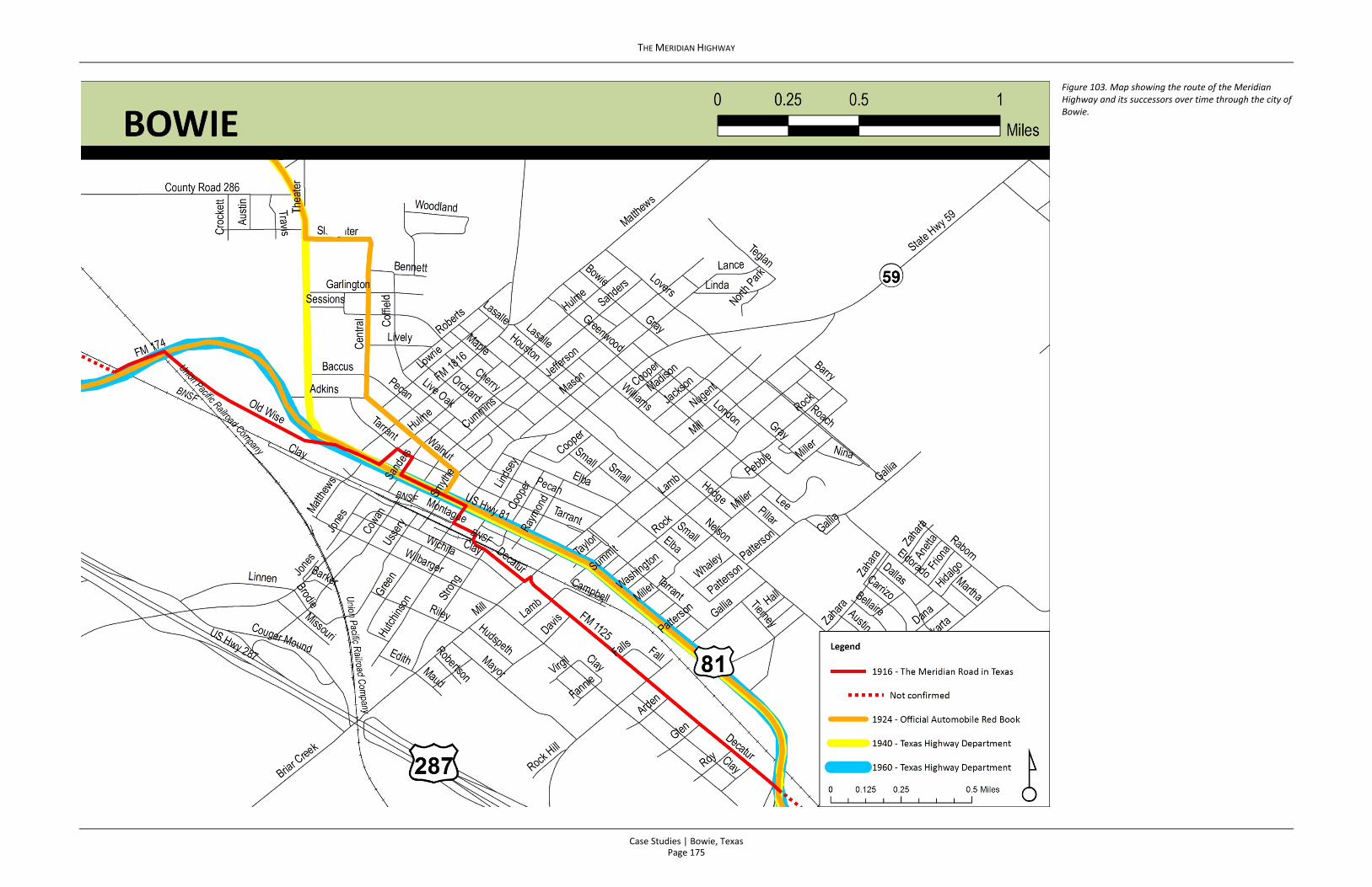
businesses, as evidenced by the former tourist court on the Sheldon Loop. The highway continued to run through downtown Bowie into the postwar era, but the ever‐growing numbers of cars and trucks led the Texas Highway Department to improve US 287. This effort created an expanded divided highway on a new alignment that bypassed the historic city center, a trend repeated in countless locations across the state. While the new highway allowed drivers the ability to avoid traffic congestion in the city center, it also hurt downtown businesses, many of which historically relied on the Meridian Highway. Nonetheless, the city still boasts several auto‐ and tourist‐related buildings that provide a tangible link to this important chapter in local history. See Figure 103 (to follow) for a map showing the Meridian Highway through Bowie over time.
Page 173
THE MERIDIAN HIGHWAY
Case Studies | Bowie, Texas
This page intentionally left blank.
Page 174
THE MERIDIAN HIGHWAY
Case Studies | Bowie, Texas
Figure 103. Map showing the route of the Meridian Highway and its successors over time through the city of Bowie.
Page 175

THE MERIDIAN HIGHWAY
Case Studies | Bowie, Texas
This page intentionally left blank.
Page 176

THE MERIDIAN HIGHWAY
Case Studies | Bowie, Texas
256 San Antonio Evening News, September 17, 1918. “State Highway Commission Meets in Monthly Session.” 257 Bridgemeister: Suspension Bridges Crossing the Red River, 1917 Terral‐Ringgold,
http://www.bridgemeister.com/list.php?type=crossing&crossing=Red+River (accessed May 18, 2015).
Page 177
THE MERIDIAN HIGHWAY
Case Studies | Bowie
This page intentionally left blank.
Page 178