IFPRI-Role of Remote Sensing Technology in PMFBY-Manoj Yadav
14
Remote Sensing-based Information and Insurance for Crops in Emerging Economy Role of Remote Sensing Technology in PMFBY: The experience from RIICE project in Tamil Nadu IFPRI Workshop on “Opportunities in PMFBY”, December 21, 2016, New Delhi Manoj Yadav, Project Advisor-RIICE, GIZ
-
Upload
international-food-policy-research-institute-south-asia-office -
Category
Government & Nonprofit
-
view
292 -
download
0
Transcript of IFPRI-Role of Remote Sensing Technology in PMFBY-Manoj Yadav
Remote Sensing-based Information and Insurance for Crops in Emerging Economy
Role of Remote Sensing Technology in PMFBY:
The experience from RIICE project in Tamil Nadu
IFPRI Workshop on “Opportunities in PMFBY”, December 21, 2016, New Delhi
Manoj Yadav, Project Advisor-RIICE, GIZ

REMOTE SENSING-BASED INFORMATION AND INSURANCE FOR CROPS IN EMERGING ECONOMIES
helps
Governments to mitigate the impact
of food shortages.
Feeding seven billion people requires a 70% increase of food production until 2050. helps to decrease the vulnerability of smallholder farmers and better
Crop insurance
Crop growth information
Rationale

REMOTE SENSING-BASED INFORMATION AND INSURANCE FOR CROPS IN EMERGING ECONOMIES
Key components of the approach
Remote Sensing, satellite images for crop area estimation and monitoring
Crop Yield Modeling for yield estimation
Application of RIICE derived area and yield information in crop insurance scheme architecture

REMOTE SENSING-BASED INFORMATION AND INSURANCE FOR CROPS IN EMERGING ECONOMIES
2
Help Governments to better plan for food crises through better crop monitoring.
Increase efficiency and effective-ness of crop insurance solutions and turn it into a viable business also in emerging markets.
1
RIICE project set-up
Funding and in-country support in two countries
Satellite data procurement & processing
Ground validation & yield modelling
In-country support in three countries; implementation, access to policy-makers,
Insurance product development
02/2012 05/2015 04/2018
Test phase: Technical proof
of concept; «dry-test» of
satellite-supported insurance
products
Scale-up phase: Nation/State-wide
upscaling of yield monitoring in
collaboration with governments.
Implementation of insurance
solutions.
Aims Partners
Timeline

Information on rice production and loss
• How much area was planted this season in each
district/block/village?
• What was the yield in each district/block/village?
• Was production more or less than last year?
• Was the harvest early or late?
• Was there a storm, flood or drought?
– Where and how much area was affected?
– How much yield was lost in such areas?
REMOTE SENSING-BASED INFORMATION AND INSURANCE FOR CROPS IN EMERGING ECONOMIES

REMOTE SENSING-BASED INFORMATION AND INSURANCE FOR CROPS IN EMERGING ECONOMIES
Large scale, high
resolution SAR-RS
of rice areas
Crop models
adjusted by
remote sensing
Smartphone based
rapid data
collection
Cloud platforms
scalable, reliable
and always on + + +
All remote sensing data stored, processed and analyzed on the cloud.
All field data collected by mobile phone, sent to the cloud over mobile or Wi-Fi network.
Timely, detailed, and accurate information made available to the users.
Turning the value chain of crop information digital
Leveraging new technologies

REMOTE SENSING-BASED INFORMATION AND INSURANCE FOR CROPS IN EMERGING ECONOMIES
Rice-YES & ORYZA
Rice yield processing
• Meteo data • Soil data • Phenological data • Management data
Yield forecast/ estimation
• Crop calendar • Crop practices • Administrative units
• Seasonal Area • Start of season date • Leaf Area Index • Seasonal dynamics • Flood damage • Drought damage
MAPscape-RICE
SAR data processing
Earth Observation data
Leaf Area Index in situ point data
• Production
Software
• MAPscape-RICE by Sarmap, Rice Yield Estimation System (Rice-YES) & ORYZA by IRRI are the central software tools of the RIICE technology
• Remote Sensing provides spatial and temporal information on crop growth including (i) crop establishment date, (ii) leaf area index (LAI)
• Allowing simulation to start at the correct time
• Measures of crops response to environment and management that cannot be easily captured across a large area
Products Input
Field validation is drastically reduced in areas with expertise over time
RIICE processing chain at a glance
validation
validation
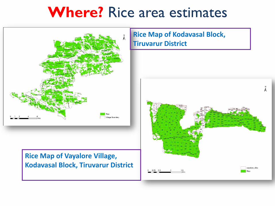
REMOTE SENSING-BASED INFORMATION AND INSURANCE FOR CROPS IN EMERGING ECONOMIES Where? Rice area estimates
Rice Map of Kodavasal Block, Tiruvarur District
Rice Map of Vayalore Village, Kodavasal Block, Tiruvarur District

REMOTE SENSING-BASED INFORMATION AND INSURANCE FOR CROPS IN EMERGING ECONOMIES When? Start of season
Cauvery delta region, Tamil Nadu

REMOTE SENSING-BASED INFORMATION AND INSURANCE FOR CROPS IN EMERGING ECONOMIES
How much? Yield estimates
Rice Yield Map of Vayalore Village of Kodavasal Block, Tiruvarur District, Tamil Nadu

REMOTE SENSING-BASED INFORMATION AND INSURANCE FOR CROPS IN EMERGING ECONOMIES
Information delivered by RIICE and its national partner Tamil Nadu University, helped relief efforts by distributing seeds in Tamil Nadu flood affected areas, after satellite data had been delivered to the state level emergency authorities.
Information delivered by RIICE helped the government to direct their relief efforts
2015 Tamil Nadu flood resulted in loss of rice area being lost
REMOTE SENSING-BASED INFORMATION AND INSURANCE FOR CROPS IN EMERGING ECONOMIES
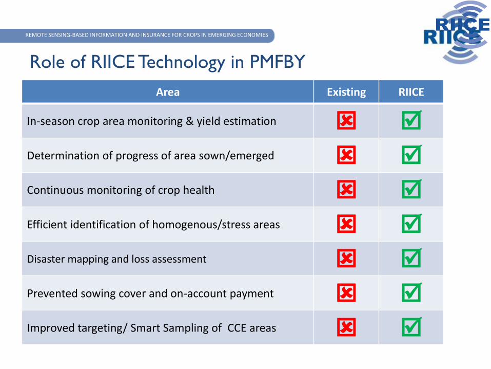
Role of RIICE Technology in PMFBY
Area Existing RIICE
In-season crop area monitoring & yield estimation Determination of progress of area sown/emerged Continuous monitoring of crop health Efficient identification of homogenous/stress areas Disaster mapping and loss assessment Prevented sowing cover and on-account payment Improved targeting/ Smart Sampling of CCE areas
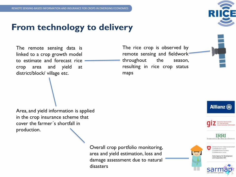
The rice crop is observed by
remote sensing and fieldwork
throughout the season,
resulting in rice crop status
maps
The remote sensing data is
linked to a crop growth model
to estimate and forecast rice
crop area and yield at
district/block/ village etc.
Area, and yield information is applied
in the crop insurance scheme that
cover the farmer´s shortfall in
production.
Overall crop portfolio monitoring,
area and yield estimation, loss and
damage assessment due to natural
disasters
REMOTE SENSING-BASED INFORMATION AND INSURANCE FOR CROPS IN EMERGING ECONOMIES
From technology to delivery