Identifying Geospatial zones to guide agricultural development planning in Malawi
16
Identifying spatial zones to guide agricultural development planning in Malawi Todd Benson, Athur Mabiso, and Flora Nankhuni New Alliance Policy Acceleration Support: Malawi (NAPAS:Malawi) project
-
Upload
ifprimassp -
Category
Presentations & Public Speaking
-
view
18 -
download
2
Transcript of Identifying Geospatial zones to guide agricultural development planning in Malawi

Identifying spatial zones to guide agricultural development planning in Malawi
Todd Benson, Athur Mabiso, and Flora Nankhuni
New Alliance Policy Acceleration Support: Malawi (NAPAS:Malawi) project

Agricultural planning and Malawi’s geographic diversity and complexity
• Malawi has significant agro-ecological diversity– Farmers in Malawi have developed a variety of farming
systems to exploit the diverse combinations of local agricultural resources
– Each farming system has a comparative advantage for production of specific set of commodities
• As a result, any agricultural policy or program using a single technical approach to improving productivity or farm profitability will fail in many places– In designing agricultural development policies, geographic
diversity of Malawian agriculture needs to be considered

Zonation scheme for agricultural planning in Malawi
• Aim is to guide strategic thinking on where specific investments could best be placed across Malawi to promote increased commercialization of agricultural production
• Scheme should reflect spatial variability both in agricultural productivity and in the profitable commercial opportunities available– Productivity primarily determined by agro-ecological factors– Profitability primarily determined by access to specific markets
• In developing the agricultural zonation scheme, interested in: – whether an agricultural commodity can be produced in an area, and– whether farmers there will consistently be able to produce the
commodity in a profitable manner
How an agricultural zonation scheme might be used in planning
• Spatial targeting of development programs in agriculture, rural transport, and market infrastructure
• Guiding location of private investment in agriculture– Primarily through public sector planners identifying where incentives
can best be placed to most profitably attract such investment
• Identifying potential areas of expansion for commercial crop production, particularly high-value crops
• Examining the current binding constraints to increasing the scale of commercial agriculture in an area– Particularly constraints that may be solved through public action and
investments

Approach
• Two levels to zonation scheme described here1. At higher, more general level, establish agricultural
development domains for Malawi• Districts categorized by three factors:
a. General agro-ecological potential
b. Physical access to markets
c. Population density
2. Thereafter, extend analysis to more local scale by considering specific agro-ecological suitability of an area for production of a commodity
• Using detailed crop suitability maps for Malawi

Agricultural development domains
• Incorporate information on determinants of agricultural development potential– Particularly for increased agricultural
commercialization• Keep it simple
– If bring in too many factors into consideration, will be difficult to use in establishing strategic objectives for agricultural development

Three spatial data layers for agricultural development domains

Aggregate data to district level

Intersect data layers to define agricultural development domains
• Different agricultural development potentialsfor the different domains– Different agricultural development
strategies should be developed for areas found in different domains
– Common general strategies possible for areas in same domain
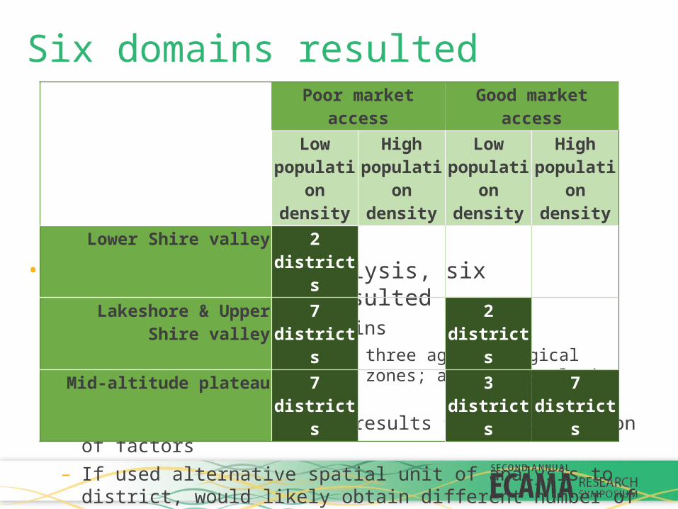
Six domains resulted
• For district level analysis, six development domains resulted– Out of 12 potential domains
• Based on intersection of three agro-ecological zones; two market access zones; and two population density zones
– Several null categories results from intersection of factors– If used alternative spatial unit of analysis to district, would likely obtain
different number of domains
Poor market access Good market accessLow
population density
High population density
Low population density
High population density
Lower Shire valley 2 districts Lakeshore & Upper Shire valley 7 districts 2 districts
Mid-altitude plateau 7 districts 3 districts 7 districts

Bringing in more detailed, sub-sector specific spatial information
• The development domain zonation aids in strategizing on agricultural development options
• However, once broad outline of spatially-informed agricultural development strategies is in place, sub-sector specific analyses are required– To determine the design of actions to be taken – Draw upon a considerably broader range of both spatial and
non-spatial data

Crop suitability maps from Land Resources Evaluation Project (LREP)
• For planning crop-related investments, LREP crop suitability maps are important information source
• LREP carried out by Ministry of Agriculture and FAO between 1988 and 1992
– Involved relatively detailed mapping of the soils and agro-climate zones of Malawi
• ‘Land units’ then identified from unique combination of soils and climate characteristics
– Suitability analysis done for each land unit across Malawi for production of specific crops and tree species
• 43 crop x management regimes; 16 tree species

Suitability maps for pigeonpea production,Blantyre ADD
• Improved crop management increases the suitability level for production of pigeonpea in many areas of the ADD
• Also expands the area over which the crop might be produced

Suitability maps for soyabean production,Blantyre ADD
• Blantyre Agricultural Development Division (ADD) somewhat more suited for pigeonpea than for soyabean production

Examples of how detailed spatial information can be used in agricultural planning
1. Use crop suitability analyses to determine, for example, whether production of alternative crops might merit closer investigation in a target area
– Critical to couple this information with findings from commodity-specific market and value chain studies
– Planners then would determine whether target farmers might profitably produce alternative crops and how they would market them
2. To foster increased investment in specific value chains, planners could use the suitability analyses to assist investors determine from where they might source the commodity
• If development aim is increased commercialization of agriculture, complementary market and value chain studies needed for use with this agricultural zonation information
Next steps• Presented an approach to developing a zonation scheme for
agricultural planning purposes• This approach and zonation scheme that resulted should now
be evaluated by experts; schemes should then be refined– Qualitatively appraise their value for development planning– Quantitative assessment of how the zones are correlated with observed
development outcomes
• Then, the agricultural zonation scheme that best informs possible approaches to address the agricultural development challenges Malawi faces should be brought into agricultural planning discussions within government