ICIMOD Seminar Kathmandu Dec.3 4, 2013 MAHAKALI … Mahakali... · India:DhauliGanga, Gori, Ram...
31
ICIMOD Seminar ‐Kathmandu‐ Dec.3‐4, 2013 MAHAKALI FLOOD‐ JUNE 2013 Case Study Presented by: Prakash Paudel
Transcript of ICIMOD Seminar Kathmandu Dec.3 4, 2013 MAHAKALI … Mahakali... · India:DhauliGanga, Gori, Ram...

ICIMOD Seminar ‐Kathmandu‐ Dec.3‐4, 2013
MAHAKALI FLOOD‐ JUNE 2013
Case Study Presented by:
Prakash Paudel

MONSOON BACKGROUND
June 2013

Monsoon Activation in June 2013

Common Glacier Range in the Himalayas
Er. Prakash Paudel

General Interpretation(Common Flooding Process adapted from USAC Report)
• Heavy Rainfall and Cloudburst in the area• Melting of Glacier to add run‐off• Heavy land erosion, slides and mass‐movement insaturated fragile geology
• Heavily loaded water flow (flood) triggeringfurther devastation
• More loss in Unprotected area and low levelsettlement while protected area more Safe
• Failure or opening of Water body add to moreflooding and devastation
Er. Prakash Paudel

MAHAKALI‐A Major Border River in Nepal

Mahakali & Its Tributaries

Mahakali Catchment1. Length of the River: 233 Km.2. Tributaries:
India: Dhauli Ganga, Gori, Ram GangaNepal: Chamelia , Surnaya & Rangun
3. Catchment area: 15260 sq.km. India: 9943 sq.km.; Nepal: 5317 sq.km.
6. Maximum Historical Discharge: 14915 m3/s 7. Average discharge: 557 m3/s8. Average rainfall Intensity: 1891 mm (1990).9. Max. rainfall intensity: 3055 mm (1990).

Extreme Rainfall in the Area
24‐Hr 17‐18 June 2013Monthly Rainfall in Dipayal:June 2013 (221 mm measured on June 18)

Extreme Rainfall & Flood Discharge in the Area in June 2013
• In India, all the 13‐districts of Uttarakhanda State felt Extreme Rainfall in the week June 13‐19, 2013
• In Dipayal, Nepal also 222 mm rainfall was recorded in 24 hr (17‐18 June 2013)
• Flood Discharge in Mahakali River in Sarda Barrage in 17‐18 June 2013 (15430 m3/sec) exceeded the Historical Records (14915 m3/sec in 1934 AD)

Recent Flood Events : June 2013(Kedarnathji Area)
Kedarnath City washed awayRoad to Gauri kund collapsed
Er. Prakash Paudel

Flood Measurement (Cusecs) in Mahakali(River Discharge from 17-June:00 hrs. to 18-Jun:1200 hrs.)
200
250
300
350
400
450
500
550
600
12 15 18 21 24 27 30 33 36
Thou
sand
s
Measured Data100‐Y (Design)
Er. Prakash Paudel

DISASTER EVENTS
PHOTO FEATURE

The Darchula Disaster• Light rainfall on 17‐Jun Day time• Flood in Mahakali started on Mid‐night 17th
• People in Darchula Khalanga started to evacuate their houses, shops and utilized structures from mid‐night (Tapovan, Bangabazar, Main Bazar, Golphai and Namaskar)
• In the morning Mahakali carried muddy flow full of debris which was deposited on full river width
• Heavy devastation started from morning of 18th
• Flow diverted to Left to enhance Channelization on this side with deposition process on the Right

River Bank Settlement in Darchula HQ
INDIA
TOWN SETTLEMENTDIVERSION STUDS
ROAD WAYDIVERSION STUDS
GARDENR.C.C. RETAINING WALL
MAJOR DIVERSION STRUCTURES
THE RIVER MAHAKALI
NEPAL DIVERSION STRUCTURES
LOW‐LAND SETTLEMENTTOWN SETTLEMENT
Er. Prakash Paudel

Loss Estimation in Darchula
HUMAN LIFE: 00 LAND LOSS 29 Ha.HOUSE (FULLY) 129 No. HUTS (FULL) 32 No.HOUSE (PARTIAL) 55 No. EDUCATION 7 No.HOUSE (RISK) 167 No. ROADS 4 Kms
Protection Wall in River Bank, Landslide (meter): 9350Cost of Replacement of Structure Land (M.NRs.): 3150Cost of Mitigation/Protection Structures (M.NRs.): 2025Cost of Emergency Mitigation Works (M.NRs.): 25
Area affected: Dasarathnagar; Chhengru/Ringertali; Ghat bazar; Tinkerkheda; Main Khalanga; Hospital; Galphai; Ghatta; Namaskar; Other Villages in Khalanga; Other VDCs.

Dhauliganga Dam Section
SECTION THROUGH CONDUIT SPILLWAY
Er. Prakash Paudel
Dhauliganga HEP Project : InformationS. N. ITEMS DATA UNIT01 CATHMENT AREA 1360 Sq. Km.02 DESIGN FLOOD DISCHARGE 3210 Cu. m./sec.03 TOTAL POWER (4 No. X 70) 280 M.W.04 DAM HEIGHT 56 meter05 ACTIVE RESERVOIR CAPACITY 1.54 Million Cu.m.06 TOTAL RESERVOIR CAPACITY 6.20 Million Cu.m.07 POND (MAX. WATER) LEVEL 1348.50 meter
08 FULL SUPPLY LEVEL 1345.00 meter09 MIN. POWER OPERATING LEVEL 1330.00 meter10 SLUICE CAPACITY 3210 Cu. m./sec.11 SLUICE CREST LEVEL 1302.00 (?) Meter12 SLUICE GATE OPENING (3X10X6) 180 Sq. meter
Er. Prakash Paudel

Observation on Sluice (Spillway) Operation
• Crest of Sluice Gates are 46.5 m. below Pond Leveland 28.0 m. below the minimum operating level
• Sluice Gates have full capacity to discharge thedesign flood of the river viz. 3210 Cu. m. / sec
• The Project broucher (POYRY) explains that the gatedSpillway or the Sluices are designed“……. to efficient flushing (of sediment) from thereservoir during periods of flood.”
• Hence when the reservoir is having excess water orsediment, the Sluice Gates are normally opened
Er. Prakash Paudel

Impression on Flood Event
• On the day of heavy rainfall, the soil of the areacrossed the limit of Saturation and failed stability,hence started falling down along with Water
• Like other rivers, Dhauliganga carried larger amountof heavy sediment and debris entering the reservoir
• In Dhauliganga Dam Power channel was closed andSluices were opened on the day to flush out theSediment during filling of the Reservoir
• The river Dhauliganga combined with main Mahakaliriver in Tawaghat which ultimately triggered Darchula
Er. Prakash Paudel

Bank Erosion by Mahakali

AFTER June 17 flood

Washed Road Way
Er. Prakash Paudel

Main Bazar Falling
Er. Prakash Paudel

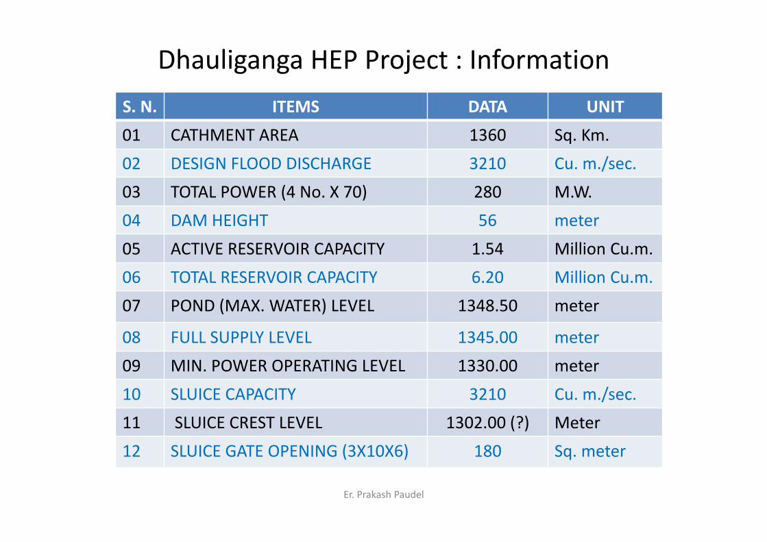
Effect on Downstream of Mahakali
Downstream of Sarada Barrage Banbasa (India) and Kanchanpur (Nepal)
Er. Prakash Paudel
Flooding in Mahakali River(Downstream of Sarda Barrage cum Bridge)
11Bhujela
1213, Pipariya
BHIMDATTA
N‐I Border
Suspension Bridge
Barrage
CHANDANI SARDA NAHAR(INDIA)
MAHAKALI NAHAR(NEPAL)
MAHAKALI RIVER
Esc. Ch. DODHARA
(Not in Scale)N
Er. Prakash Paudel

Pipariya: Buried Settlement/Agriculture

STATUS & REQUIREMENT
RECORD MANAGEMENT, INFORMATION SHARING &FORECASTING MECHANISM

Status of Records, Analysis & Communication
• Less attention paid to this area regarding analysis of Rainfall data & Flood forecasting
• No Hydrological Stations established on middle & upper part of Mahakali (Nepal)
• Flood data managed by India in Tanakpur/Banbasa• No on‐time data sharing mechanism between Nepal & India
• Very poor information sharing system between stake holders inside the country
• Poor lesson learning practice and less public‐awareness

RECOMMENDATIONS
1. Real time data mechanism for Mahakali and its major Tributaries
2. Real Time Data accessible to the Stakeholders3. The flood forecasting & Information mechanism4. Effective Warning system & Awareness Program5. Legal provision & Practical action against River
Encroachment6. Committed Master (Action) Plan by the
Government with adequate shared resources

THANK YOU ALL !
Mahakali River Flood in Darchula Nepal _18-June-2013.mp4