ICAO International Flight Plan
13
Form Approved OMB No. 2120-0026 U S Department of Transportation Federal Aviation Administration International Flight Plan PRIORITY ADDRESSEE(S) <=FF <= FILING TIME ORIGINATOR <= SPECIFIC IDENTIFICATION OF ADDRESSEE(S) AND / OR ORIGINATOR 3 MESSAGE TYPE <=(FPL 7 AIRCRAFT IDENTIFICATION 8 FLIGHT RULES TYPE OF FLIGHT <= 9 NUMBER TYPE OF AIRCRAFT WAKE TURBULENCE CAT. / 10 EQUIPMENT / <= 13 DEPARTURE AERODROME TIME <= 15 CRUISING SPEED LEVEL ROUTE <= 16 DESTINATION AERODROME TOTAL EET HR MIN ALTN AERODROME 2ND ALTN AERODROME <= 18 OTHER INFORMATION <= SUPPLEMENTARY INFORMATION (NOT TO BE TRANSMITTED IN FPL MESSAGES) 19 E/ ENDURANCE HR MIN PERSONS ON BOARD P/ EMERGENCY RADIO R/ UHF VHF ELBA SURVIVAL EQUIPMENT / POLAR DESERT MARITIME JUNGLE JACKETS / LIGHT FLUORES UH F VHF D / DINGHIES NUMBER CAPACITY COVER COLOR <= A/ AIRCRAFT COLOR AND MARKINGS N / REMARKS <= C/ PILOT-IN-COMMAND )<= FILED BY ACCEPTED BY ADDITIONAL INFORMATION FAA Form 7233-4 (7-93)
Transcript of ICAO International Flight Plan

Form Approved OMB No. 2120-0026
U S Department of Transportation Federal Aviation Administration
International Flight Plan PRIORITY ADDRESSEE(S)
<=FF <=
FILING TIME ORIGINATOR <=
SPECIFIC IDENTIFICATION OF ADDRESSEE(S) AND / OR ORIGINATOR
3 MESSAGE TYPE
<=(FPL 7 AIRCRAFT IDENTIFICATION 8 FLIGHT RULES TYPE OF FLIGHT
<= 9 NUMBER TYPE OF AIRCRAFT WAKE TURBULENCE CAT.
/ 10 EQUIPMENT
/ <= 13 DEPARTURE AERODROME TIME
<= 15 CRUISING SPEED LEVEL ROUTE
<= 16 DESTINATION AERODROME
TOTAL EET HR MIN ALTN AERODROME 2ND ALTN AERODROME
<= 18 OTHER INFORMATION
<= SUPPLEMENTARY INFORMATION (NOT TO BE TRANSMITTED IN FPL MESSAGES)
19
E/ ENDURANCE
HR MIN PERSONS ON BOARD
P/
EMERGENCY RADIO
R/ UHF VHF ELBA
SURVIVAL EQUIPMENT
/ POLAR DESERT MARITIME JUNGLE
JACKETS
/ LIGHT FLUORES UH
F VHF
D /
DINGHIES NUMBER CAPACITY COVER COLOR
<= A/
AIRCRAFT COLOR AND MARKINGS
N / REMARKS
<= C/
PILOT-IN-COMMAND )<=
FILED BY ACCEPTED BY ADDITIONAL INFORMATION
FAA Form 7233-4 (7-93)
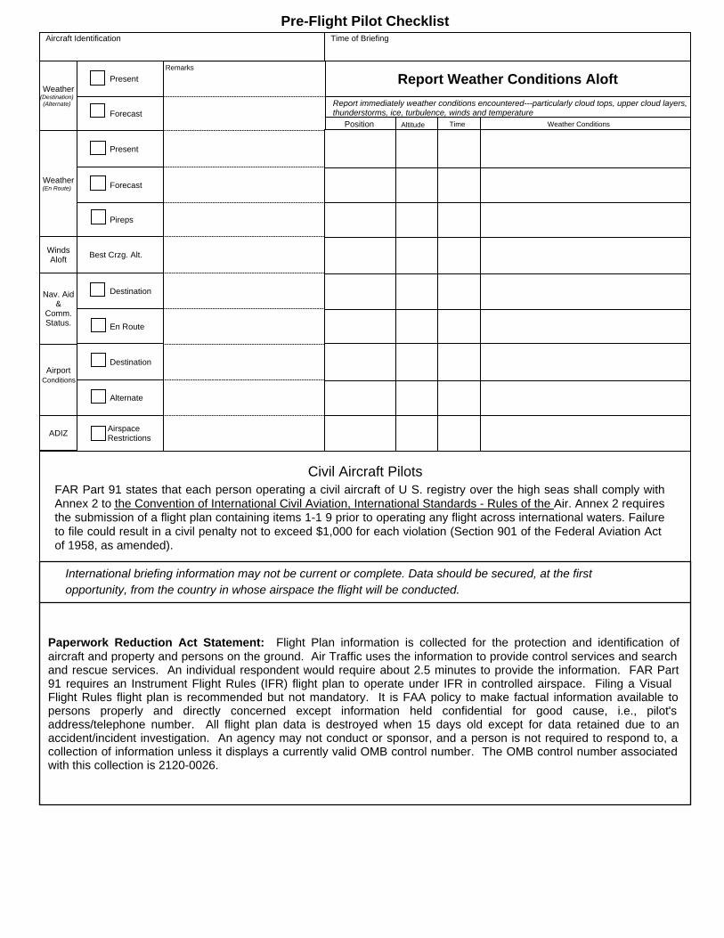
Pre-Flight Pilot Checklist Aircraft Identification Time of Briefing
Weather (Destination) (Alternate)
Present Remarks
Forecast
Report Weather Conditions Aloft Report immediately weather conditions encountered---particularly cloud tops, upper cloud layers, thunderstorms, ice, turbulence, winds and temperature
Position Altitude Time Weather Conditions
Weather (En Route)
Present
Forecast
Pireps
Winds Aloft Best Crzg. Alt.
Nav. Aid &
Comm. Status.
Destination
En Route
Airport Conditions
Destination
Alternate
ADIZ Airspace Restrictions
Civil Aircraft Pilots FAR Part 91 states that each person operating a civil aircraft of U S. registry over the high seas shall comply with Annex 2 to the Convention of International Civil Aviation, International Standards - Rules of the Air. Annex 2 requires the submission of a flight plan containing items 1-1 9 prior to operating any flight across international waters. Failure to file could result in a civil penalty not to exceed $1,000 for each violation (Section 901 of the Federal Aviation Act of 1958, as amended).
International briefing information may not be current or complete. Data should be secured, at the first opportunity, from the country in whose airspace the flight will be conducted.
Paperwork Reduction Act Statement: Flight Plan information is collected for the protection and identification of aircraft and property and persons on the ground. Air Traffic uses the information to provide control services and search and rescue services. An individual respondent would require about 2.5 minutes to provide the information. FAR Part 91 requires an Instrument Flight Rules (IFR) flight plan to operate under IFR in controlled airspace. Filing a Visual Flight Rules flight plan is recommended but not mandatory. It is FAA policy to make factual information available to persons properly and directly concerned except information held confidential for good cause, i.e., pilot's address/telephone number. All flight plan data is destroyed when 15 days old except for data retained due to an accident/incident investigation. An agency may not conduct or sponsor, and a person is not required to respond to, a collection of information unless it displays a currently valid OMB control number. The OMB control number associated with this collection is 2120-0026.

Instructions for Completing the International Flight Plan I. General
a. Use BLOCK CAPITALS when completing each item. b. Adhere closely to the prescribed formats and manner of specifying data. c. Commence inserting data in the first space provided. Where excess space is
available, leave unused spaces blank. d. Insert all clock times in 4 figures UTC. e. Insert all estimated elapsed times in 4 figures (hours and minutes). f. Shaded area preceding Item 3 - to be completed by ATS and COM services, unless
the responsibility for originating flight plan messages has been delegated. NOTE- The term "aerodrome" where used in the flight plan is intended to cover also sites other than aerodromes which may be used by certain types of aircraft; e.g., helicopters or balloons. II. Instructions for Insertion of ATS Data
a. Complete Items 7 to 18 as indicated hereunder. b. Complete also Item 19 as indicated hereunder, when so required by the appropriate
ATS authority or when otherwise deemed necessary. NOTE- Item numbers on the form are not consecutive, as they correspond to Field Type numbers in ATS messages. ITEM 7: AIRCRAFT IDENTIFICATION (MAXIMUM 7 CHARACTERS) INSERT one of the following aircraft identifications, not exceeding 7 characters:
a. The registration marking of the aircraft (e.g., EIAKO, 4XBCD, N2567GA), when: (1) In radiotelephony the call sign to be used by the aircraft will consist of
this identification alone (e.g., OOTEK), or preceded by the ICAO telephony designator for the aircraft operating agency (e.g., SABENA OOTEK);
(2) The aircraft is not equipped with radio; OR
b. The ICAO designator for the aircraft operating agency followed by the flight identification number (e.g., KLM511, NGA213, JTR25) when in radiotelephony the call sign to be used by the aircraft will consist of the ICAO telephony designator for the operating agency followed by the flight identification (e.g., KLM511, NIGERIA213, HERBIE25).
NOTE- Provisions for the use of radiotelephony call signs are contained in Annex 10, Volume II,

Chapter 5. ICAO designators and telephony designators for aircraft operating agencies are contained in Doc 8585 - Designators for Aircraft Operating Agencies, Aeronautical Authorities and Services. ITEM 8: FLIGHT RULES AND TYPE OF FLIGHT (1 OR 2 CHARACTERS) Flight rules INSERT one of the following letters to denote the category of flight rules with which the pilot intends to comply:
• I if IFR • V if VFR • Y if IFR first)* • Z if VFR first)*
*If indicating either Y or Z, specify in Item 15 the point or points where a change of flight rules is planned. Type of flight INSERT one of the following letters to denote the type of flight when so required by the appropriate ATS authority:
• S if scheduled Air Transport • N if non-scheduled air transport operation • G if general aviation • M if military • X if other than any of the defined categories above.
ITEM 9: NUMBER AND TYPE OF AIRCRAFT AND WAKE TURBULENCE DATA Number of aircraft (1 or 2 characters) INSERT the number of aircraft, if more than one. Type of aircraft (2 to 4 characters) INSERT the appropriate designator as specified in ICAO Doc 8643, Aircraft Type Designators, OR, if no such designator has been assigned, or in case of formation flights comprising more than one type, INSERT ZZZZ, and SPECIFY in Item 18, the number(s) and type(s) of aircraft preceded by TYP/. Wake turbulence category (1 character) INSERT an oblique stroke followed by one of the following letters to indicate the wake turbulence category of the aircraft:
• H - HEAVY, to indicate an aircraft type with a maximum certificated take-off mass of 136,000 kg or more;
• M - MEDIUM, to indicate an aircraft type with a maximum certificated take-off mass of less than 136,000 kg but more than 7,000 kg;
• L - LIGHT, to indicate an aircraft type with a maximum certificated take-off mass of 7,000 kg or less.
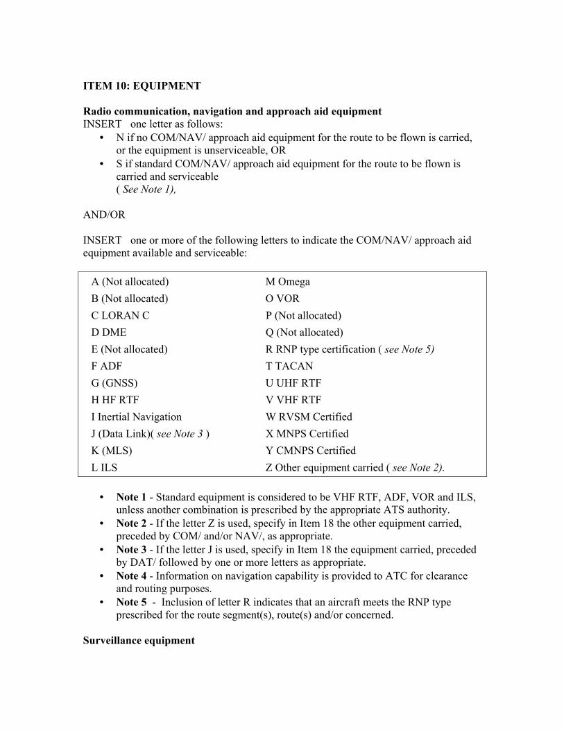
ITEM 10: EQUIPMENT Radio communication, navigation and approach aid equipment INSERT one letter as follows:
• N if no COM/NAV/ approach aid equipment for the route to be flown is carried, or the equipment is unserviceable, OR
• S if standard COM/NAV/ approach aid equipment for the route to be flown is carried and serviceable ( See Note 1),
AND/OR INSERT one or more of the following letters to indicate the COM/NAV/ approach aid equipment available and serviceable: A (Not allocated) M Omega B (Not allocated) O VOR C LORAN C P (Not allocated) D DME Q (Not allocated) E (Not allocated) R RNP type certification ( see Note 5) F ADF T TACAN G (GNSS) U UHF RTF H HF RTF V VHF RTF I Inertial Navigation W RVSM Certified J (Data Link)( see Note 3 ) X MNPS Certified K (MLS) Y CMNPS Certified L ILS Z Other equipment carried ( see Note 2).
• Note 1 - Standard equipment is considered to be VHF RTF, ADF, VOR and ILS,
unless another combination is prescribed by the appropriate ATS authority. • Note 2 - If the letter Z is used, specify in Item 18 the other equipment carried,
preceded by COM/ and/or NAV/, as appropriate. • Note 3 - If the letter J is used, specify in Item 18 the equipment carried, preceded
by DAT/ followed by one or more letters as appropriate. • Note 4 - Information on navigation capability is provided to ATC for clearance
and routing purposes. • Note 5 - Inclusion of letter R indicates that an aircraft meets the RNP type
prescribed for the route segment(s), route(s) and/or concerned. Surveillance equipment
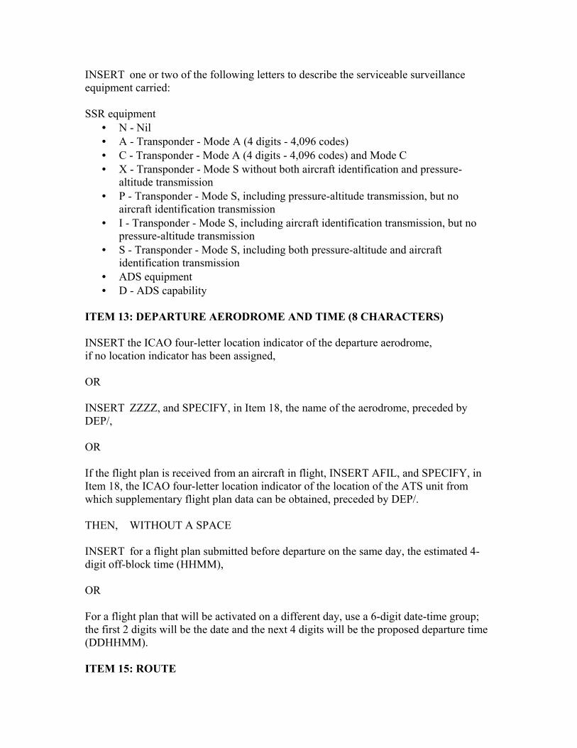
INSERT one or two of the following letters to describe the serviceable surveillance equipment carried: SSR equipment
• N - Nil • A - Transponder - Mode A (4 digits - 4,096 codes) • C - Transponder - Mode A (4 digits - 4,096 codes) and Mode C • X - Transponder - Mode S without both aircraft identification and pressure-
altitude transmission • P - Transponder - Mode S, including pressure-altitude transmission, but no
aircraft identification transmission • I - Transponder - Mode S, including aircraft identification transmission, but no
pressure-altitude transmission • S - Transponder - Mode S, including both pressure-altitude and aircraft
identification transmission • ADS equipment • D - ADS capability
ITEM 13: DEPARTURE AERODROME AND TIME (8 CHARACTERS) INSERT the ICAO four-letter location indicator of the departure aerodrome, if no location indicator has been assigned, OR INSERT ZZZZ, and SPECIFY, in Item 18, the name of the aerodrome, preceded by DEP/, OR If the flight plan is received from an aircraft in flight, INSERT AFIL, and SPECIFY, in Item 18, the ICAO four-letter location indicator of the location of the ATS unit from which supplementary flight plan data can be obtained, preceded by DEP/. THEN, WITHOUT A SPACE INSERT for a flight plan submitted before departure on the same day, the estimated 4-digit off-block time (HHMM), OR For a flight plan that will be activated on a different day, use a 6-digit date-time group; the first 2 digits will be the date and the next 4 digits will be the proposed departure time (DDHHMM). ITEM 15: ROUTE

INSERT the first cruising speed as in (a) and the first cruising level as in (b), without a space between them. THEN, following the arrow, INSERT the route description as in (c). (a) Cruising speed (maximum 5 characters) INSERT the True Air Speed for the first or the whole cruising portion of the flight, in terms of:
• Kilometers per hour, expressed as K followed by 4 figures (e.g., K0830), or • Knots, expressed as N followed by 4 figures (e.g., N0485), or • Mach Number, when so prescribed by the appropriate ATS, to the nearest
hundredth of unit Mach, expressed as M followed by 3 figures (e.g., M082). (b) Cruising level (maximum 5 characters) INSERT the planned cruising level for the first or the whole portion of the route to be flown, in terms of:
• Flight Level, expressed as F followed by 3 figures (e.g., F085; F330); or • Altitude in hundreds of feet, expressed as A followed by 3 figures (e.g., A045;
A100); or • Standard Metric Level in tens of metres, expressed as S followed by 4 figures
(e.g., S1130); or • Altitude in tens of metres, expressed as M followed by 4 figures (e.g., M0840); or • For uncontrolled VFR flights, the letters VFR.
* When so prescribed by the ATS authorities. c) Route (including changes of speed, level and/or flight rules) Flights along designated ATS routes INSERT, if the departure aerodrome is located on or connected to the ATS route, the designator of the first ATS route, OR If the departure aerodrome is not on or connected to the ATS route, the letters DCT followed by the point of joining the first ATS route, followed by the designator of the ATS route. THEN INSERT each point at which either a change of speed or level, a change of the ATS route, and/or a change of flight rules is planned,

NOTE- When a transition is planned between a lower and upper ATS route and the routes are oriented in the same direction, the point of transition need not be inserted. FOLLOWED IN EACH CASE By the designator of the next ATS route segment, even if the same as the previous one, OR By DCT, if the flight to the next point will be outside a designated route, unless both points are defined by geographical coordinates. Flights outside designated ATS routes INSERT points normally not more than 30 minutes flying time or 370 km (200 NM) apart, including each point at which a change of speed or level, a change of track, or a change of flight rules is planned. OR When required by appropriate ATS authority(ies), DEFINE the track of flights operating predominantly in an east-west direction between 70°N and 70°S by reference to significant points formed by the intersections of half or whole degrees of latitude with meridians spaced at intervals of 10 degrees of longitude. For flights operating in areas outside those latitudes, the tracks shall be defined by significant points formed by the intersection of parallels of latitude with meridians normally spaced at 20 degrees of longitude. The distance between significant points shall, as far as possible, not exceed 1 hour's flight time. Additional significant points shall be established as deemed necessary. For flights operating predominantly in a north-south direction, define tracks by reference to significant points formed by the intersection of whole degrees of longitude with specified parallels of latitude which are spaced at 5 degrees. INSERT DCT between successive points unless both points are defined by geographical coordinates or by bearing and distance. USE ONLY the conventions in (1) to (5) below and SEPARATE each sub-item by a space. (1) ATS route (2 to 7 characters) The coded designator assigned to the route or route segment including, where appropriate, the coded designator assigned to the standard departure or arrival route (e.g. BCN1, B1, R14, UB10, KODAP2A).

NOTE- Provisions for the application of route designators are contained in ICAO Annex 11, Appendix 1, while guidance material on the application of an RNP type to a specific route segment(s), route(s) or area is contained in the Manual on Required Navigation Performance (RNP) (Doc 9613). (2) Significant point (2 to 11 characters) The coded designator (2 to 5 characters) assigned to the point (e.g., LN, MAY, HADDY), or, if no coded designator has been assigned, one of the following ways:
• Degrees only (7 characters): o 2 figures describing latitude in degrees, followed by "N" (North) or "S"
(South), followed by 3 figures describing longitude in degrees, followed by "E" (East) or "W" (West). Make up the correct number of figures, where necessary, by insertion of zeroes, e.g. 46N078W.
• Degrees and minutes (11 characters): o 4 figures describing latitude in degrees and tens and units of minutes
followed by "N" (North) or "S" (South), followed by 5 figures describing longitude in degrees and tens and units of minutes, followed by "E" (East) or "W" (West). Make up the correct number of figures, where necessary, by insertion of zeroes, e.g. 4620N07805W.
• Bearing and distance from a navigation aid: o Identify the navigation aid (normally a VOR), in the form of 2 or 3
characters, then the bearing from the aid in the form of 3 figures giving degrees magnetic, THEN the distance from the aid in the form of 3 figures expressing nautical miles. Make up the correct number of figures, where necessary, by insertion of zeros; e.g., a point 180° magnetic at a distance of 40 nautical miles from VOR "DUB" should be expressed as DUB180040.
(3) Change of speed or level (maximum 21 characters) The point at which a change of speed (5% TAS or 0.01 Mach or more) or a change of level is planned, expressed exactly as in (2) above, followed by an oblique stroke and both the cruising speed and the cruising level, expressed exactly as in (a) and (b) above without a space between them, even when only one of these quantities will be changed. Examples:
• LN/N0284A045 • MAY/N0305F180 • HADDY/N0420F330 • 4602N07805W/N0500F350 • 46N078W/M082F330 • DUB180040/N0350M0840
(4) Change of flight rules (maximum 3 characters) The point at which the change of flight rules is planned, expressed exactly as in (2) or (3) above; as appropriate, followed by a space and one of the following:

• VFR if from IFR to VFR • IFR if from VFR to IFR
Examples:
• LN VFR • LN/NO284A050 IFR
(5) Cruise climb (maximum 28 characters) The letter C followed by an oblique stroke; THEN the point at which cruise climb is planned to start, expressed exactly as in (2) above, followed by an oblique stroke ; THEN the speed to be maintained during cruise climb, expressed exactly as in (a) above, followed by the two levels defining the layer to be occupied during cruise climb, each level expressed exactly as in (b) above or the level above which cruise is planned followed by the letters PLUS, without a space between them. Examples:
• C/48N050W/M082F290F350 • C/48N050W/M082F290PLUS • C/52N050W/M220F580F620
ITEM 16: DESTINATION AERODROME AND TOTAL ESTIMATED ELAPSED TIME, ALTERNATE AERODROMES(S) Destination aerodrome and total estimated elapsed time (8 characters) INSERT the ICAO four-letter location indicator of the destination aerodrome followed, without a space, by the total estimated elapsed time, OR If no location indicator has been assigned, INSERT ZZZZ followed, without a space, by the total estimated elapsed time, and SPECIFY in Item 18 the name of the aerodrome, preceded by DEST/ NOTE- For a flight plan received from an aircraft in flight, the total estimated elapsed time is the estimated time from the first point of the route to which the flight plan applies. Alternate aerodrome(s) (4 characters) INSERT the ICAO four-letter location indicator(s) of not more than two alternate aerodromes, separated by a space, OR If no location indicator has been assigned to the alternate aerodrome,

INSERT ZZZZ and SPECIFY in Item 18 the name of the aerodrome, preceded by ALTN/ ITEM 18: OTHER INFORMATION INSERT 0 (zero) if no other information, OR, any other necessary information in the preferred sequence shown hereunder, in
the form of the appropriate indicator followed by an oblique stroke and the information to be recorded:
EET/ Significant points or FIR boundary designators and accumulated estimated elapsed times to such points or FIR boundaries, when so prescribed on the basis of regional air navigation agreements, or by the appropriate ATS authority. Examples: EET/CAP 0745 XYZ0830 EET/EINN0204
RIF/ The route details to the revised destination aerodrome, followed by the ICAO four-letter location indicator of the aerodrome. The revised route is subject to reclearance in flight. Examples: RIF/DTA HEC KLAX RIF/ESP G94 CLA APPH RIF/LEMD Explanation: The intent of the RIF is to facilitate a reclearance to a revised destination, normally beyond the filed destination airport. If prior to departure, it is anticipated that depending on fuel endurance in flight, a decision may be made to proceed to a revised destination, this can be shown on the flight plan by writing RIF/ and providing the information concerning the possible revised route and destination. For example, a flight crew at Anchorage, Alaska, might really want to fly nonstop from Anchorage to Tokyo (RJAA). But if strong headwinds are forecast, the crew might have to file to land at Chitose because of fuel endurance. However, if the crew files RIF/RJAA in the ICAO flight plan and later realizes that fuel endurance is sufficient to fly on to Tokyo, the crew can ask for reclearance to Tokyo. The RIF/RJAA in the flight plan prepares air traffic controllers for the inflight request should it be possible.
REG/ The registration markings of the aircraft, if different from the aircraft identification in Item 7.
SEL/ SELCAL Code, if so prescribed by the appropriate ATS authority. OPR/ Name of the operator, if not obvious from the aircraft identification in Item 7. STS/ Reason for special handling by ATS; e.g., hospital aircraft, one engine
inoperative; e.g., STS/HOSP, STS/ONE ENG INOP. TYP/ Type(s) of aircraft, preceded if necessary by number(s) of aircraft, if ZZZZ is
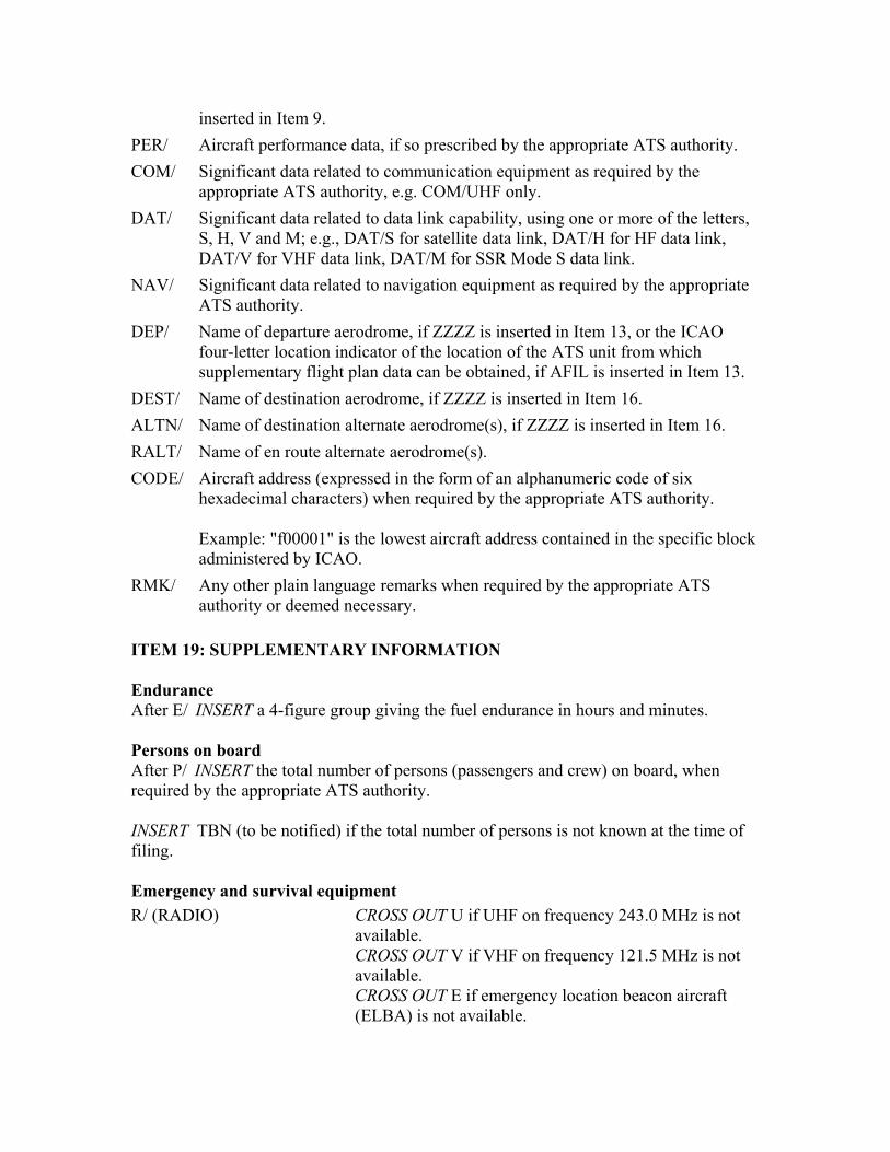
inserted in Item 9. PER/ Aircraft performance data, if so prescribed by the appropriate ATS authority. COM/ Significant data related to communication equipment as required by the
appropriate ATS authority, e.g. COM/UHF only. DAT/ Significant data related to data link capability, using one or more of the letters,
S, H, V and M; e.g., DAT/S for satellite data link, DAT/H for HF data link, DAT/V for VHF data link, DAT/M for SSR Mode S data link.
NAV/ Significant data related to navigation equipment as required by the appropriate ATS authority.
DEP/ Name of departure aerodrome, if ZZZZ is inserted in Item 13, or the ICAO four-letter location indicator of the location of the ATS unit from which supplementary flight plan data can be obtained, if AFIL is inserted in Item 13.
DEST/ Name of destination aerodrome, if ZZZZ is inserted in Item 16. ALTN/ Name of destination alternate aerodrome(s), if ZZZZ is inserted in Item 16. RALT/ Name of en route alternate aerodrome(s). CODE/ Aircraft address (expressed in the form of an alphanumeric code of six
hexadecimal characters) when required by the appropriate ATS authority. Example: "f00001" is the lowest aircraft address contained in the specific block administered by ICAO.
RMK/ Any other plain language remarks when required by the appropriate ATS authority or deemed necessary.
ITEM 19: SUPPLEMENTARY INFORMATION Endurance After E/ INSERT a 4-figure group giving the fuel endurance in hours and minutes. Persons on board After P/ INSERT the total number of persons (passengers and crew) on board, when required by the appropriate ATS authority. INSERT TBN (to be notified) if the total number of persons is not known at the time of filing. Emergency and survival equipment R/ (RADIO) CROSS OUT U if UHF on frequency 243.0 MHz is not
available. CROSS OUT V if VHF on frequency 121.5 MHz is not available. CROSS OUT E if emergency location beacon aircraft (ELBA) is not available.

S/ (SURVIVAL EQUIPMENT)
CROSS OUT all indicators if survival equipment is not carried. CROSS OUT P if polar survival equipment is not carried. CROSS OUT D if desert survival equipment is not carried. CROSS OUT M if maritime survival equipment is not carried. CROSS OUT J if jungle survival equipment is not carried.
J/ (JACKETS) CROSS OUT all indicators if life jackets are not carried. CROSS OUT L if life jackets are not equipped with lights. CROSS OUT F if life jackets are not equipped with fluorescent. CROSS OUT U or V or both as in R/ above to indicate radio capability of jackets, if any.
D/ (DINGHIES) (NUMBER) CROSS OUT indicators D and C if no dinghies are carried, or INSERT number of dinghies carried; and
(CAPACITY) INSERT total capacity, in persons, of all dinghies carried; and
(COVER) CROSS OUT indicator C if dinghies are not covered; and (COLOR) INSERT color of dinghies if carried. A/ (AIRCRAFT COLOR AND MARKINGS)
INSERT color of aircraft and significant markings.
N/ (REMARKS) CROSS OUT indicator N if no remarks, or INDICATE any other survival equipment carried and any other remarks regarding survival equipment.
C/ (PILOT) INSERT name of pilot-in-command. III. Filed by INSERT the name of the unit, agency or person filing the flight plan. IV. Acceptance of the flight plan Indicate acceptance of the flight plan in the manner prescribed by the appropriate ATS authority. V. Instructions for insertion of COM data Items to be completed:
• COMPLETE the top two shaded lines of the form, and • COMPLETE the third shaded line only when necessary, in accordance with the
provisions in PANS-RAC, Part IX, 2.1.2, unless ATS prescribes otherwise.