IC7 - Welcome to Environmentenvironmentclearance.nic.in/writereaddata/FormB/...CONTENTS bed Page--e...
33
Transcript of IC7 - Welcome to Environmentenvironmentclearance.nic.in/writereaddata/FormB/...CONTENTS bed Page--e...


-
L-cMf' If'-/O.· ~/01 IC7 /)i7, ~, or: ·~CMj.r
[Under Rule 27-A (3) of the Odisha Minor Minerals Concession(Amendment) Rules, 2014]
FOR
MADANPUR LATERITE STONE QUARRY OVER 3.22 ACRESIN VILLAGE MADANPUR UNDERGHASIPURA TAHASIL OF
KEONJHAR DISTRICT, ODISHA(2015-16 to 2019-20) 1 P P BOY ED
Lessee - Sudhanshu Shekhar Malik
I
~~~'~f s. K, Dalal)
O'l'uty Director Geolo,y0/0 tbe Joint Director G-eo\oIlY
r:eonjba: -
Prepared by
TRILOCHAN PANDA, RQPREGN. No. - RQP/BBS/112/2012/A
BHUBANESWAR-751012

CONTENTS
bed
Page--
e I.'
"am IBM ...
III- I
g ~=JForm-ZB
~
51. No. Titl--
1 Consent letter from L------
2 Certificate from RQP3 Copy of RQPCertific4 Certificate and Unde
-
5 Executive Summary6 Mining Plan in prescri7 Annexure
-8 Plates
-
eesse
--ate frrtakin

List of AnnexureTitle No.
. Copy of Tahasildar letter I
. Certified copy of RoR , IICopy of Land Schedule III-_.. _-- f--. -_Feasibil ity Report of Revenue IVInspector _______.__ _,Declaration by Lessee and R.I. anT Vpillar posting on lease boundary I
Identity and Address proof of VI ~lLessee _Undertaking by Lessee for VII Idepositing BG towards Financial IAssurance j_._

Is~3 III ,4 IV~~_5 V Co
I Pl6 VI ; P
R~·-------'----.
No. Plate No. I T-- ------j------. --_---. _ I I' Location M
. II Lase Planrface Plaeo_logicalmpositean (for flve years) IMCP ·~--r~1-:2~0~0~0~
__ __L____ ___!
itle Scale----__ ..
ap , 1:5000016"=1 mile
n 1:1000Plan 1:1000Development 1:1000.
List of Plates

oG"f:CEItI7'.~~~~~.~1[( ..It,.~.;If \ ~
CONSENTlETTER FROM lESSEE} ,)t~\:I ,j_, \}: :
1. .). ,~1~~\ ~,' t' '" i ,I
The Mining Plan along with Progressive Mine Closure" \,'::~~"'~~~\r.~?~~~t~..I~'Madanpur Laterite Stone Quarry of Sri Sudhanshu Shekhar ~ea
of 3.22 acres in village Madanpur under Ghasipura Tahasil of Keonjhar District,
Odisha has been prepared by Sri Trilochan Panda, Regd. No.
RQP/BBS/112/2012/A, 3M3E Global, Bubaneswar.
I request the Deputy Director Geology, Office of the Joint Director Geology,
Keonjhar to make further correspondence regarding the Mining Plan with the
same recognised person in the address as: Sri Trilochan Panda, RQP;Regn. No.-
~ RQP/BBS/112/2012/A, 3M3E Global, 1789/19, Nuasahi, Nayapalli,
Bhubaneswar-751012, Odisha, India.
\'1I hereby undertake that all the modifications so made in the Mining Plan by the
recognised person be deemed to have been made with my knowledge and
consent and shall be acceptable to me and binding on me in all respects.
Place:Madanpur
Date: 12.06.15
~htYl?rtv s-.h 01_ /)1)jj<Signature of Lessee (in full)
Address:ViI.: DantiaGP:GadabandhogodaPS:RamachandrapurDist.: Keonjhar
....._,--,
')'/Trilochan Panda
RQP/BBS/112J2012JA

Certified that the provisions of Odisha Minor
CERTIFICATE FROM RQP
. Progressive Mine Closure of Plan in respect of Madanpur Laterite Stone Quarry
over an area of 3.22 acres in village Madanpur under Ghasipura Tahasil of
Keonjhar District prepared under Rule 27 A (3) of OMMC (Amendment) Rules}
2014 of Sri Sudhanshu Shekhar Malik and wherever specific permissions are
required, the lessee will approach the concerned authority.
Certified that the information furnished in this MINING PLAN along withPROGRESSIVEMINE CLOSUREPLANare correct t~ the best of my knowledge.
Trilo1,,'~RQP/BBS/112/2012/ A
\\
~rr ->Trilochan 1;;" ..
RQP/ii&s111212012IA

diRCf ~cnR I GOVERNMENT OF INDIA~,Ji31I(;j::U / MINISTRY OF MiLNES
:JiHctll:i ~ ~~l / INDLAN BUREAU OF
L_ , ___j
3i~{iIIJIM -~ c);' w it m;=lRlT -Q"lITUT ~
(~ ~ ~JW!~.1960 q, R:''f<rnm1'r ~ m;ff)
CERTIFICATE OF RECOGNITION AS QUALIFIED PERSON, (Under Rule22C,ofMineral Concession Rules, 1960)
m. RUlikf 'Q~I ~,,~ 'Jlff:.r@ ~ q~ f)<;TCffifrC1~IHITf dJrn, <;i;q~f@ 'Cltf"c "QCT~ -"
3})cilcAf=CH. 3-lT~~rr ~ m- 3-tR' ~f2.'R 3>LlT f?;m ~¥T ~'; dm Q~lc4 3-l1kfr ~ 3W 3q:J.m COTfiCil~\jjCiCh flT8:-(l" ~ *-" Ch-T<IlC1c:T ~ ~{ Cfi{<;l ~ ~ ~:qI'4(i ~;qd1lClrfl ~~c.0it; f.)~~t\T "$~ 3itrllQIH urfi.ti c)) ~ dt Jl~ -r.t?r '~ t;-!Shri Trilochan Panda S/o .Late Golakha Bihari PandaR/o vill- 1789/19 Nuasahii, Po-, .Nayapalli, Bhubaneswar, Odisha., whose Photograph and signature is affixed herein above, havinggiven satisfactory evidence of his qualification & experience is hereby RECOGNISED under Rule 22C ofthe Mineral Concession Rules, 1960 as a Qualified person to prepare Mining plans.
~ Qv-l''4Ci ~ ~His registration number is ..RQPIBBS/112/20 121A[~ JlIG '4rll.l0.crt *r .31C1fu c):;- ~ Jly;:q 6' ;JlT ~ 23.04.2022.cnT 8d1TR ~I
This recognition is valid for a period of 10 years ending on 23.04.2022 _~ 8:RT ~ ~c;:r ~ Jt JIC'1(i ~ ~;r on! 0ff"c{ ~ ~ Jt ~ urrror t:Gf
CTrQ11 fcimr 0ffi!'JlT ~ ~r J[WJIT!
This certificate will liable to be withdrawn I cancelled in the event of furnishing the wronginformation / documents in the Mining plan submitted by him.
~~ tnG=r ~I Regional Controller of Mines
~~' ~I Indian Bureau of Mines
~-'U'{m I ~ww,*~egionREGlOHA~,~~~:;'~F MIN::>
INOIN BUREAU OF MINES~flill-II.)BANESWAR
~ I Place Bhubaneswar
~ I Date 24.04.2012
0J_/Tri'echan Pand~ ,
ItQ'/aaS/11212012/A -, Cii \).,. ,~. .I": .•
.., ":1,,"

~~~';'-0'" <~II',}" 0.,.. \.l,,~ 'tf. \
"f... t".\\CERTIFICATE AND UNDERTAKING FROM TH~l SSE ~H
~. r (i' . ,;j'This is to certify that a" the statutory rules, regula~)67r~,orde'rs etc r_" ...YJ.~.'" ,)".,." ,,_.1 I .'
made by Central/ State Government, statutory organis~ti~~L~.!-~
etc and the provisions of Mines Act, Rules and regulations made
thereunder have been observed in the Mining Plan along with
Progressive Mine Closure Plan (prepared under Rule 27 A (3) of
OMMC (Amendment) Rules, 2014) by Sri Trilochan Panda, RQP of
Madanpur Laterite Stone Quarry over an area of 3.22 acres in vi"age
Madanpur under Ghasipura Tahasil of Keonjhar District.
2. I, Sri Sudhanshu Shekhar Malik (lessee) do hereby undertake that
wherever specific permissions are required, the applica nt will
approach the DGMS and the standards prescribed by DGMS in
respect of miner's health will be strictly implemented.
Place: Madanpur
Date: 12.06.15
5:a)jQ?lrdv Y'-it062 mJl4Signature of Lessee (in full)
Address:Vi I.: DantiaGP:GadabandagodaPS:RamachandrapurDist.: Keonjhar

of Dantia is required to prepare a Mining Plan in
respect of the Madanpur Laterite Stone Quarry allotted
to him on long term basis (for five years) on a
competitive bidding process as per Rule 27 of OMMC
-(Amendment) Rules, 2014.
In compliance to the above, an attempt has been made-'
to prepare the Mining Plan of the above allotted area
based on the precise area map and information
provided by the revenue authorities and field
information.
Madanpur laterite stone deposit is located near Saikula
(Barpada)-Pathargoda road which connects to Jarada
- Deogaon Road at distance of about 2 km. This
deposit extends over 3.22 Ac and laterite is exposed
over a smali area of 20m x 15m towards the south-
western side of the deposit.
Prima facie, the overburden appears to be very less
(about 0.3m) towards south-western side. This may
1
. '\tr~Trilochsi ptanda
RQ,./ifiS/112/2012JA

increase towards northern side. An avera
average production of 1008 rn".
In view of the locational advantages of the deposit the
laterite blocks to be raised from this quarry may
increase in future. If required, as per existing rules,
there is scope for modification of this Mining Plan in
future depending on market demand and quality of
blocks.
2 ~/Trilechan Pan.a
~QP/BBS/112/2012/~-- -- ----------- -------------------

FORM-ZB
[See Rule 27-A (3) of the Odisha Min,or Minerals Co _ ....,~""(Amendment) Rules, 2014] ----
MINING PLAN FORWINNING OF LATERITE STONEFROMVILLAGE a: PANCHAYATMADANPUR UNDERGHASIPURA
TAHASll OF KEON.JHARDISTRICT
(Category: 8)
--------,-- l-----------j-------------------------j
1. Name 6: Address of the Lessee I Sudhanshu Shekhar Malik
I Si 0 Dibakar Malik
I Village: Dantia
i GP: Gadabandagoda
Ips: RamachandrapurI D~sL:KeonjharII
2. Particulars of the-----An:?a--~Plot ilo.--=-3364------------I
(Acreage, Boundary Description I Khata no. - 756
6: Land Schedule): (Attach! Village - f'Aadanpur
location map and surface plan IArea- 3.22 acres
showing the existing features of I (Location Map --Plate-I)
the area with contours at 2 mI. Tope-sheet - F4504
interval) I 4) Longitude: 860 05' 54.0" to11¥l\01f.D
~ Latitude: 210 07' 26.3" to
21" 07' 31.8" N
Q Tahasil: Ghasipuraf S. K, Dolol)Del'ut, .Dire~tor Geolo" I t. District: Keonjhar
0/0 the JOint DIrectorGeolo., J.........C:,oDjba'- ----------- ------ ----------
3 ~/Trillc(an Pan.1iI
-"QP/8SS/112/2012/A
I_j
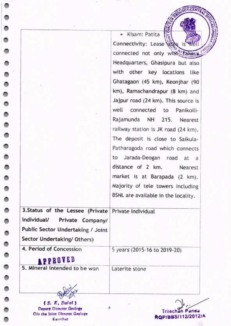
i il Kisam: Patitai
I Connectivity: Lease....".....L"".,.t
connected not only
Headquarters, Ghasipura but also
with other key locations like
Ghatagaon (45 krn), Keonjhar (90
krn), Ramachandrapur (8 km) and
Jajpur road (24 km). This source is
well connected to Panikoili-Rajamunda NH 215. Nearest
railway station is JK road (24 krn).
The deposit is close to SaikulaPatharagoda road which connects
to Jarada-Deogan road at aII distance of 2 km. Nearest i
market is at Barapada (2 km). IMajority of tele towers including
BSNLate available in the locality.
5 years' (2015-16 to 2019-20)
individuall3.Status of the Lessee (Private Private Individual
Private Companyl
Public Sector Undertaking I Joint
Sector Undertaking! Others)
4. Period of Concession
PBoYED i5. Mineral intended to be w~;n--'----r[aterltestone
I
(S. K, Dolal,Deput, Director Geolo,,.
0/0 the Joint Director Geolo,.," eon;ha:
4 r:)r/Trilochan Panda
t(QP/88S/11212012/A

6. Name, Address & Registration-lTrilochan Panda
No. of RQP,preparing the mining 13M3E GlobalI
plan with validity of/1789/·t,9, Nuasahi,I Recognition Nayapalli,
Bhubanesv\'ar-751012
. Odisha, India
Registration No.
r RQP IBBSI 112120121A:I Valid up to 23.04.2022iI (Copyenclosed)II
II
7. Order N~--&-date- of ITetter no. 2129/ Dtd. 22.5.2015 of"
Competent Authority gra~ting I Tahasildar, Ghasipura
the concession I (Copy attached: Annexure-I)I
(copy of the Order to be IIIII
,---------.-----:-------.----1-------.-18. if, forest area, whether forest i No forest land 1S involved in theI
obtained (Attached I tease area.I .
, I
copy of forest clearancej i~ 'I
attached)
clearance
based on the exploration, if any, durability, ease of sizing,carried out in the area or on availability in close proximity to
10call>iri.aJ\Jr~D construction sites and low cost,
the laterite blocks are in demand'\
~ I for several construction purposes. IC s. K. Dalal' I Laterite is the weathered product I
---e~Bittctor-~Y-----·--------_l_----·0/0 the Joint Director GeololY
5 »>:Trilochan Pano aRQP/88S/112/20t2/A

derived from vario
through the
lateritisation.
occurs below soil and morrum /
lateritic soil. Due to enrichment of
iron, at places, this laterite is very
hard at specific horizons, which,
I in turn, enhancesits raisingcost.
laterite, in the lease, is exposed
over a small area of 20m x 15m
towards its south-western side.
Overburden appears to be very
less (about O.3m) towards south
western side. This may increase
towards northern side. Based onthe field observations an average
thickness of O.7m (Top soil-O.3mI and morruml lateritic soil-OAm) has,been considered.
As observed in the adjoiningquarry, laterite of thickness 1.2m
iI has been exposed and isIi continuing to depth. Based on this
I observation the thickness of 1.2m!
I has been considered to assess theI proved reserve followed byI probable reserve..Resource assessment has been
, s. 1f, Dolol)De"uty Director Geototy
0/0 tbe Joint Director Geolo..,
6 jrr~Trilechan Pantla
"QP/liliS/112/2012/A

I GEOlOGISectional I Length Volume Se
Sectionarea of of of arlaterite influence laterite(m2) (m) (m3) -_(-----
A B C D=B*C-~ f---G1-G1' 67 47 3149
629 47 29563---+--
G2-G2' 46 81 3726 j
443 81 ~~:~f-
I The resource/ reserve
estimated based on geological I
cross-section method. Two cross
sections along east-west have
been drawn. G1-Gt' section
I covers the laterite patch exposedi in the lease area.
ctionalea ofOB
CAL RESERVE lI Sectional Volume
area ofof top categorY,~top soil
(m2) soil (m3)t·~~--~I------~---F-- .,. I
6(j---r--31021 102 4794 PROVED
NEA--r:I
J-I--I
---0±~.
VolumeofOB(m3)
Mineable reserve, as furnished below, hasbeen calculated by excluding
the reserve locked in 7.5m safety zone from the geological reserve.
,
MIsectionaT----r---
f Length of Volumearea 0 ;_Section I . I Influence of laterite
aterite () ( 3)(m2) m m,
---A B C D=B*C
-I f-------G1-Gl' 49 36 1764
-467 36 16812--_.
G2-G2' 37 65 2405:0 U1t n lIL lis --._ 22945•.• ~d6 43926
..------
~, S. s,Dalal'
Oef'ut., Director Ge01n,.,0/0 the [cine Directer GeoIo.,.
U !L.__
-
IBlE RESERVE:;ectionarr-v I Sectional
Volumeoumearea ofarea of I
of top CategoryOB ofOB top soil(m2) (m3) (m2)
soil (m")
F------49 1764 73 2628 PROVED------ ---0 0 0 0 PROBABLE30 1950 31 2015 PROVED0 0 0 0 PROBABLE
-- I---
-_.-
"1
TriIOCh~P~~QP/i.S/112120121A

10. Mining
a. Whether manual or semi- Manual
mechanizedor mechanized
c. Whether drilling and blasting will Drilling and blasting will not be
be made use of, If yes, state required as laterite blocks of
monthly quantity of explosivesto particular sizeare to be recoveredbe consumed
b. If semi-mechanized or NotApplicable
d. Benching pattern (Height x Onebench(3mx3m)is proposedto be
Width): developed during the course of
laterite mining.
mechanized, number, type and
capacity of machinesto be used
laye. Face out (attached WhileDevelopmentPlan)
1
~~f S. K, Dolol)
Oermty Director Geolo,y0/0 the Joint Oir~ctor Geolo"
Keonjha:
8
preparing year-wise
development plan, mining loss has
been assumed to be 5% and the
volume of each laterite block has
been considered as O.0243m3
(O.50mxO.27mxO.1Bm).Development
Plan for 5 years is herewith attached
(Plate-V) for reference.
1/Trilochan Panda .
RQII,BIS/112/,G iLIA

YEAR~WISE DEVELOPMENT ~\~ ~~tfiJ.------.-,------,1,---------' r----.-----.-----7\t-'\'~#~~\--- N):';: ..~~Section I i Area of Volu,,"S-' 'W.P"'" ~ ~
Year
Iconsidered Bottom RL [' No. O~f i rock I \\~_(.>_ ~ecoverablv'.< I
aterrte :-c . _........~.~~-for I (m) I benches mass (m3) .•,<,__':'~d:iW~. _
Development (tn') , '.,,~~ ....ABC t----O--·- - E G=EX F ·H=G/0.0243
1STYEAR G1-G1' 70 1 28--_--;--------+-_._--+----.---+--------j
G1-G1' 70 1 28 36
~~~~~: ~~ ~ -~:---~=-=.~:.---t-+---~-:::--+---.-+-----IG1-G1' 70 '1 28 t-: 36TOTAL ·--r-------
IIi Length ofII influence
(m)F36
of the year or period of the
concession
1008 41481io08 414811008 414811008 41481
--1008 41481._-_--5040
-2nd YEAR3rd YEAR4th YEAR5th YEAR
f. Quarry Floor Level (RL) at the end 70m
t----------------- 1-- ---.. _g. Quantity of minerai to be won list year- 1008m3 (41481blocks)
. 1 -
(Annual Level of Production) I 2nd year- 1008m3 (41481blocks)I
i3rd year- 1008m" (41481blocks)I14thyear··1008 m3 (41481blocks)
s" year- 1008m3 (41481blocks)
h. Quantity of overburden to be-----l460rr?- of-overburden (mostly soilTRemoved (Show location of such morrum/ lateritic soil) has been
disposal in Development Plan) generatedestimated beto
I considering O.4m as the averageII thickness of DB. This may be utilised
I for road development .
.. p PRO i_£D --.---L----:-:~;-----------II. Whether heavy blasting to be I Not applicable
adopted: If yes, location of nearest I 'habitation (to be shown in the I
., L ~J _J
~?(, S. Jr, Dolol ,
Oeflut., Director -GeolOlY0/0 tbe Jt\int DirecttSr Geolo,"
9
It .I"\ft;"'a-
there is no operation.l!!ROvtn I
k. Brief description onmeih9(fOf----t There is no requirement
procurement and storageof I explosives during'---- ----~~fi-----·_·-L --
~4\;f( S. 1(, Dat ol ) J.O ~ ~"/
Deput, Di-r.ector.neolo,y Trilochan Panda0/0 the JDint Directe" Geolo_' ftQP/j8S/112/2012/A
V !L._
SurfacePlan)
j. Safety precautions to be adopted I All
be taken during miningof laterite
in the quarry. While raising
laterite blocksfrom the identified
I area the quarry will be open tillI
I the material is exhausted/ up to
the mining limit. In suchcase,all
precautionarymeasuresincluding
fencing of the quarry boundary
shall . be done to avoid any Ipossible accident. Particularly Iduring rainy seasonthe operation
may be ceased for four to five
I months and the Quarry may be
filled up with rain water. Water
I level shall dependon the quantity
I of rainfall, volume of seepage/Ipercolation and prevailing water
table. To avoid any possible
accident in the laterite quarry
strict security arrangementneeds
to be in place, particularly when
of
mining

ir consist ofI
I soil. During mining the voLume of
I waste generated shall be utilized'I
I for constructionl repair of roads
I and other infrastructure.
I Arrangement has been made for
storage of waste to be generated
during mine operation at the
earmarked dumping site
I (Development Plan-V).
_________________________ .. 1 ~____ _ __ i(a) Location (show it: in the lLocation (towards west) has'beenl
I
I----------------------------~---~~ ~ _(b) Area covered: ! 200mL (0.02 Ha)
(c)Environmental safeguards"for=tDisposal I
during dry and rainy season and its lease area. During rainy season
I.volume of water in the quarry will
I be increased. Hence, it may notI
~i be possible for continuing
If i~ - 1 operation during rainy season.L IS. K,Dolo/) i
DeJ)uty Director GeolofY 1
-e-to-lhe-Joint-DirectorGeOio.,------- -~-------------(Ceonjha:
Waste Disposal to
Development Plan) shown in the Development Plan
---I12 Mine drainage: General slope of the area is
(Give details of total make of water towards north-west side of the
11 ~/Trilochal( Panda
, ft_QP/8.S/112/201~A

13 Mineral Processing : (Give details Blocks
of processing including sizing, sorting, 0.0243) rrr' sgeneration of rejects/fines etc)
constructionpurposes.14" a) No. of trees to be uprooted due Ntl.to mining,operation:
b) Programmeof Plantation: About 120 nos. of trees will be
plantedwithin the safetyzone.
15Manpower .
a. Supervisory (inclusive of statutory 2no.personnel)
b. Non- Supervisory (skilled, semi- 23 nos.skilled & unskilled)
c. OMS Considering7 monthsworkingand
average annual production of10D8m) the OMS comes to
O.250m3 (considering25 working
days in a month)
OMS = Annual production1working monthsl working days in
a monthl nos. of unskilledworkers deployed in a day =1008/7/25/23 = O.250m3
lPPROVED16 Use of Mineral : (Specification and Exclusivelyused for the purposemonthly quantity to be dispatched be of construction of buildings and
furnished) roads. Further, the material can
'\\,r/Trilochan~anda
ftQfI/lri.S/112120 121A
,s. X, Doiol )Deputy Director Geololl'
0/0 the Joint Director Geolo.,1l ....... U• ...._
12

t--------::::-- -------------------+-----'-'-----,---,------,,-~::_l'h_2"'_:__=____.} ~--ta. For domestic use
!-----:-----::=-----------------------t-:---:-:-:------------------b. For export Nil
t-----:---:-:---~:_::_----------------17MineClosurePlan --~------------~
f-------=---:-c----:-------------------t-=--c:---:--a. Describe the process/activities to Rejects/ waste that will be
be undertaken for reclamation and generated in course of mining
rehabilitation in respect of the shall be utilized for reclamationfollowing of minedout area. Thevolumeof
waste will not be adequate for
complete reclamation to bring
the land into its original
condition. Hence,the left out pit
shall be utilised as water
reservoir which will cater to the
domestic as well as agricultural
needs of the locals. Besides,
aquaculture may be taken up on
commercial basis improving the
socio-economiccondition of the'
village.
1. Minedout land ----------tlle proposedminedoutareawill
1 P PRO 11i.n I be 1151m2 (0.115Ha) j'-----------~-----------------L-. ___
(S. K, Dalal) 13 ~~-Deputy Director GeoIo." Trilochan "an ••
0/0 the Ieine Director GeololY ''.'''.is'11212012IA________ ~'~en=n~ihr·~ __

if. Waste/reject dump Rejects!
generated m
shall be kept
identified area
utilization in reclamation of
minedout area.
iii. Top-soil stack and its utilization Top soil of O.3m average
thickness(345m3) shall be stacked
I separately at the earmarked siteI
I (150m2) for future utilizationII du,ringplantation. (ReferPlate-V)
(b) Financial assurance: (To be To be furnished by the Lesseeto
furnished as a bank guarantee in the Competent Authority before
respect of the area to be put to signingof the LeaseAgreement.
useat the rate of Rs.perhectare) For the above purpose an
undertaking from the Lesseefor
depositingthe BGis enclosed.
.....
~~
1S. s,Dolol,ne"uty Director GeoJo,y
0/0 the Ioint Director Geoio••Keoniha:
14 ()~'YTrilochan ~da
RQP/8S~/11212() 12/A

District,hereby solemnly affirm that the plans and programmes in this mining
plan will be scrupulously implemented by mel us and II We will be
strictly held responsible for any deviation thereof. II We also hereby
certify that the provisions of Mines and Minerals (Development &
Regulation) Act, 1957 and the Mines Act, 1952 and Rules and
I. Regulations made under these Acts, along with the provisions of Odisha
18. Certificate
II We, the
• Minor Minerals Concession Rules, 2004 will be strictly adhered to while
implementing this mining plan and wherever specific permissions will
be required, II We will approach the concerned authorities of"-
Directorate General of Mines Safety and the State Government as thecase may be.
Su)/(YO> ~ Jejtt,dL!lJL A(Signature of the concessionaire)
, s. s, Dalal' .Del'ut, Director Geolo,,.
010 tbe Joint Director Geolo.,reonjba:

To
OF THE T.AHASll.DARJ GH .No.-21~___rr0uzifDated_2 ?:j_!ij1!>~
.;w. OFFICE
The joinl Direclor, GC';o;ogy,Keonihar
Sub. Submission of Minin~JPlan & Pr:efeasibility report.° Sir,
I am to say that one Sri Sudhansu SekharMaiik of Danha being thehighest bidder of Maddnpur Laterite stone quarry (Sairat Case nO-7/15-16) has
deposited the earnest money of Rs.91. 180/- Vide M Rno 617974/15 5.15 towards 5I
years long term quauy lease in his favour from 2015-16 to 2019-20
As per r~ule 27-A(i) of OMMC(Rules) 2014 Mining Plan &
Prefeasibility report is rnanda tory pnar to grant of E.C. In view of the Notlclflcatlon
No. S.0.1533 dI. 14·09 2006 of Gov t of Indra Min istry of Forests & En vironment. .
In enclosing herewith the Land Schedule & Trace map of the SourceMadanpur Latente stone quarry (Khata no. iSoPlot nO.3364 AreaAc3. 22 of Mouza
Madanpur.) I Would request you to submit the mining plan within the prescribed
time of two montns so as to enable this office to take further appropriate action at
Copy submitted to the l\dditional
Memo NOo iOatecJ_0 __ 0 _
Yours ~thfUIlY'
~. -'I~'TahaSild;~~~;~
. OHA ~lP 1.",
Maaistrate,Keonjharffhe Sub-Collector,Anandapur for favour of ki'ld information and necessaryactiono
OISt
.Memo No ° /0 areo ---_o .._
Copy forwarded to Sri Sudhansu Sekhar Malik S/O Dibakar Malik of Dantia forinformation and necessqry action.
'~~Ir-Ta hasilda r,Ghasipura

______ 910;;/90/1 C _
ifll~OlIlUIS!I'~D""epue_ Ue400lJJl~'~ .
. liN:)&) ','1,'5_9 (WSOIl),';/) Of. .----------- •.-- •.--- ..----- ..----------.,-----..•---"--_. __._~t!. ._. ._.,.__"..•.__..__~O'(••_.__••_•• ' ••• _••••_, ••
h":>\!16h_PI!:':Il?la 0
SL6~/OL/LO: ~\!16 6l%5B l:j~rw
-.--.--------- ..---- ..... r-----·-·--·----~··-·---:-::.:-::~
I
II
00'0
BD:l he'? Ih('j'!2
: 5) b DS (S1I:38___•• L • ••• g" ............... __.i __--------_ •. __ .•_-._-------_ .•_----------------._---_ .. -·---_····_--_._- __ .I ._.
---------r-'-
~1~16t2 h131139bl~lt2
~~
JO :(')86 ~[266
dt3 [%~£) Qia'l:jl() (')16Q
'l:j16 (')I~B (
99{38 (jCjf:jf{3 .
{38d6f:}:

'.J.~. r. V( .....~ •• ",.
~,0 <;:;'9Q (j
\'~Qq(\~Iq
364
';<)i:{yl~~l~j~7(~ii~f$:~;~;1-·:~:(5.~:.~c:?"fJiij·---·----' -, .--;-._-- ....__ .<
,~~,,~I,,- -~-:-=1"---..{], ?' .; GS[~lol I
",·"'··_"t-·''''··,,_·'''''····,·,,·,,eo E' E' '
3 220
! '""... _" l_.__,..,.J1i
! '.',
,.'
I. "
,~ "'., -
c :
-._-.._ .. -__ . -_.. _ ...__ .._----_-
E' 9
"31/05/2015

i~~~~~'-I,~~~\~ ~- eIc_~;~~\~,\I _, ~~~\~\)I <->j .
~
- \
~
8-)ritXS! _;_t\~ !~-\\ I ! ~-\\
G~\ I I
I .\,_ I ~(\~! I'"
I J .I~ j-_'-- J _ __ _.:i._J' __ _J_____J__ ____;__. _
'9'..\~
~ ~~\~~
~ I~~ I I IL~._ _I__ __ '__J ---+----1 -J-----__.
..'tl\6~'G~L_
'r\\~ ~~~~"
r'\~~~~

1.2.3. Plot No.
'--...~c..u~~-"" - \
4. Plot on which quarry operation is g()ing on:. ~5. Material available in the source atpresent.spectfvlng width, length &
depth:6. Plot having 6 mtrs. depth:
7. Whether quary operation is going on otherthan the quarry area:8. If yes, Khata No. Plot l'Jo, Area Name of the Rayat
" .9. Whether the quarry is fc'~lsible: yes'·10. If yes, Khata No. Plot No. Area. Kisam (with land plan and land schedule)
11.Whether the quarry are;~ involves any tree growth: ~ 0
12..Whether the quarry hamper agricultural operation in the nearby area: ~13.Whether quarrying ope.utionwlll be
(a) Detrimentalto protection of natural environment: tJ\,~
(b) Dangerous to public health and communication: ~...::o
(c) Dangerous to dily public structure/ monuments and building: l>\,\s>(d) Cause of pollution: ~~.'-
14.Whether the land involved is kept in Rakhita or 5 5 Khata or reserved foranv communal purpose 'iI-'\.~
1S.Whether the quarry involves any forest area to attract the provision ofForest Conversion Act:
16.Whether the quarry site IS located within 100 rntrs distance for railwayline/ NH/ SH: ~o
17.lf any plot is adjacent to archaeological structures: ~I8.Views of H.I.: May be COl .sidered forAuctionzOuarrv lease
~-~~~ ~~~q .~ .'f\-Q-..~ ~~~~\~
~.\A ~~.uJr~ ~~~k- .~~~\ ~~ ~~~ ;'_'~lb(,'{j vv~~_,.~~' .e;.~,~..cr~· ~:::=
I Signatureandsea:f~~j;~rSAINKUL
\}v/Trilochan "anda
RQP/iiS/11212012/A

Annexur .... t
Declaration
I do hereby certify that the allotted ~ quarry lease
area 0«], '.221cre~ectares under village: M:,JVJV'{"~"2__ gb~~H:~ \JJ) (YI.z__District: ~_<M.~~as_ been duly demarcated. through
posting of pillars by the concerned R.1. in.my presence.
Countersigned
~1:> -. ?M? \b~"t5·[Seal an.d.Signat. ure of R.I.]
lbvc,mue lnsp~(.U'ISAJN.KUL
,,~~ 8d<"tIcJ$L_~'"[Lessee]
. ,
~/Trllechan ~anda
"QP/88S/11212012/A

IELECTION COMMISSION OF INDIA
~IQ&1~ ~if190;;> 1ir;j«lO;;>
IDENTITY CARD ORJ21/146/314.459.eb!'O'~ eQ
EI~ctors Name6QI6'Q~' 0;;>191
Sudhanshushekhar Malik~:~r~51S11l1Q 91"&
Father's/Mother's/Husband's Name F - Dibakar Malik~GlIl9l101l~19I1~ 0;;>191 €l _ Gi~IIiQ 9I~1i
I Sex I ~ Male €J.~~iI Age as on 1.1.1994:' 29
e.e.eC'C'b' 6Q ~~~ 9C'L__.._..._
"
Address:Vill.lWard· PimtiaAnnexure _viG.PJTown: Gadabaridagpaa ...-P.S. RarnachandrapurDist. Keonjhar
OIiQI :~191I~lg Qlgl:ll9lIet~~Q 611f1'Q>1"'6611G'1810;;>1 QI9I9~q_Q~~ . ()1i~~Q
!ThiS c~rd can be used as an Identity Cardl'under different Government Programmes. 1
1-' '~Qeb!9~ e2 ~~. Q I<lQIiIQ1 6.6._.IQO;;>ISQJ~~9E1; 'Cl2 'Ol.6tl ~~2IQ IiQI-¬ llI6i)€II~'Q> I _
~>.
facsimile' Signature ofElectoral Registration Officer
Ramachandrapurtor Ramachandrapur A.C.QI9I9~~Q. QI9I9~qQ30t11/94 ~~IO;;>I(lQI.~if19O;;>9Ig~Q MI9~-,«)/~ ~/,C''IS SQ~~IiQQ !!Ie'I(lQ~ Q~GlIi
rjr/Tr"I.chan Panda
RQPI88S/11212012JA

'J. ~neXUrf;' VIII.
UNDERTAKING
I, Sri Sudhansu Sekhar fv1aliik, At: Dantia, PS: Ramachandrapur
Dist: Keonjhar, do hereby undertake that I shall deposit the,
Bank Guarantee, as required by the competent authority
towards financial assurance in respect of Madanpur Laterite
Stone Quarry (Area-3.22 acres, Village-Madanpur, Tahasil
Ghasipura) before signing the lease deed.
c;~C("qjtA &h~q_ ;r1Jtk(Sri Sudhansu Sekhar Mallik)
10.07.2015
TriiOCha~a~RQ,./BIS/112/20121,A