i LAND USE PLANNING FOR INFORMAL SETTLEMENTS ...
66
i LAND USE PLANNING FOR INFORMAL SETTLEMENTS: INCORPORATING COMMUNITY-DRIVEN PLANNING IN THE LOCAL INTEGRATED DEVELOPMENT PLAN A case study of Hanipark, Matjhabeng Local Municipality by Gosego L. Maselwanyana Submitted in partial fulfilment of the academic requirements for the degree of Master of Environment and Development (Land-Information Management) in the Centre for Environment, Agriculture and Development School of Environmental Sciences Faculty of Science and Agriculture University of KwaZulu-Natal Pietermaritzburg 2007 Supervisor: Dr Denis Rugege
Transcript of i LAND USE PLANNING FOR INFORMAL SETTLEMENTS ...

i
LAND USE PLANNING FOR INFORMAL SETTLEMENTS:
INCORPORATING COMMUNITY-DRIVEN PLANNING IN THE
LOCAL INTEGRATED DEVELOPMENT PLAN
A case study of Hanipark, Matjhabeng Local Municipality
by
Gosego L. Maselwanyana
Submitted in partial fulfilment
of the academic requirements for the degree of
Master of Environment and Development (Land-Information Management)
in the Centre for Environment, Agriculture and Development
School of Environmental Sciences
Faculty of Science and Agriculture
University of KwaZulu-Natal
Pietermaritzburg
2007
Supervisor: Dr Denis Rugege

ii
SUMMARY
The problem of informal settlement is well established in many urban areas of South
Africa and in many other developing countries. Efforts to upgrade urban informal
settlements have largely failed due to lack of effective participation in the planning
processes which are conventionally driven by professional land use planners.
This study was carried with the objectives to determine the causes of failure of
conventional land use planning in upgrading informal settlements and the resulting spatial
implications. There also sought to investigate current best practices of in-situ upgrading of
informal settlements and to use these in formulating a proposed approach that would
include community-driven planning into the local integrated development planning.
In a case study of the Hanipark Informal Settlement in Matjhabeng Local Municipality,
Free State Province key informants identified from the various stakeholders involved in the
upgrade process were interviewed in order to establish the causes of failure of the planning
processes. Ortho-rectified imagery of 2000 and 2003 were also analysed to establish the
spatial trends of the informal settlement during the informal settlement upgrade of the
study area.
The results showed that the in-situ upgrade of the Hanipark Informal Settlement was
largely driven by the Matjhabeng Local Municipality planners using the conventional
technical approach with minimum participation of the beneficiary informal settlement
dwellers. It was revealed that while the upgrade planning was in progress, new informal
dwellers continued to settle. Over a three-year period between 2000 and 2003, the number
of informal settlement dwellers increased by more than 1,000 households, increasing
settlement density and expanding the area extent of the informal settlement by more than
10 ha.
The study results suggest that an adaptation of the current practices centred on the
UN_HABITAT procedure could be more successful in informal settlement upgrading. A
three-phase approach is proposed to include as the first phase, the formation of a
Stakeholders Forum which conducts a land audit, identifies policy instruments and

iii
accessible resources and establishes a partnership with the private sector; as the second
phase, a land zoning procedure and the establishing of a suitable land tenure framework
and carrying out detailed planning and implementation as the third phase.

iv
PREFACE
This thesis represents the original work of the writer hereof and has never been submitted
in any form, part or entirely to any other university. Where use has been made of the work
of others, these have been duly acknowledged in the text.
Signed: …………………………… Gosego Lawrence Maselwanyana 202523945
As the Candidate’s Supervisor, I have approved this mini-dissertation for submission.
Signed: …………………………… Dr Denis Rugege Research Supervisor

v
ACKNOWLEDGEMENTS
This thesis could not have been written without the patience, love, and support of my wife,
Mothootsile and my children, Moalosi, Thotloetso and Kealeboga who have constantly
supported me whilst I was most of the time away from home.
I would also like to thank Dr Denis Rugege, my Supervisor and a Mentor for the excellent
guidance I have received from him.
Faith Nzimande for the invaluable assistance with the administrative issues, you deserve
my thanks.
My colleagues, especially Peter Brislin and Oganne Ramagaga who have been constantly
encouraging and reminding me of the importance of the path I have taken, also deserve my
thanks.
To my colleagues at Welkom District Office (FSPLRO), thank you for your support and
understanding.
Finally, I would like to thank the Department of Land Affairs for affording me the
opportunity to further my studies and for acquiring better knowledge and skills.

vi
TABLE OF CONTENTS
LIST OF FIGURES..........................................................................................................viii
LIST OF TABLES.............................................................................................................. ix
ACRONYMS........................................................................................................................ x
CHAPTER 1: INTRODUCTION....................................................................................... 1 1.1 BACKGROUND............................................................................................... 1 1.2 PROBLEM ANALYSIS.................................................................................... 1 1.3 SETTLEMENT LAND ACQUISITION GRANT (SLAG) AND
MUNICIPAL PROCESSES ............................................................................. 2 1.4 RESEARCH OBJECTIVES.............................................................................. 4 1.5 RESEARCH HYPOTHESIS............................................................................. 4 1.6 RESEARCH QUESTIONS ............................................................................... 5 1.7 METHODOLOGY ............................................................................................ 5 1.8 LITERATURE REVIEW .................................................................................. 5 1.9 COLLECTION OF SECONDARY DATA ...................................................... 5
1.9.1 GIS analysis of informal settlement expansion trends in the study area ......................................................................................... 5
1.9.2 Interviews with key informants ........................................................ 6 1.9.3 Materials ........................................................................................... 6
CHAPTER 2: LAND USE PLANNING FOR INFORMAL SETTLEMENT UPGRADING ............................................................................................................. 7
2.1 INTRODUCTION ............................................................................................. 7 2.2 CONSTITUTIONAL AND LEGISLATIVE FRAMEWORK IN GENERAL13
2.2.1 Institutional framework .................................................................. 14 2.3 LAND USE PLANNING AND MANAGEMENT BEST PRACTICE ......... 16
2.3.1 Informal land market ...................................................................... 16 2.3.2 International Federation of Surveyors ............................................ 19 2.3.3 The benefits of participation........................................................... 21 2.3.4 The practicalities of participatory planning.................................... 21 2.3.5 Well-informed planning ................................................................. 22 2.3.6 Services........................................................................................... 22 2.3.7 Approaches to the upgrading of informal settlement in-situ .......... 24
CHAPTER 3: INTEGRATED DEVELOPMENT PLANS (IDP)................................. 27 3.1 INTRODUCTION ........................................................................................... 27 3.2 WHY IS IT NECESSARY TO DO AN IDP?................................................. 28
3.2.1 Effective use of scarce resources.................................................... 28 3.2.2 It helps to speed up delivery........................................................... 28 3.2.3 It helps to attract additional funds .................................................. 29 3.2.4 It strengthens democracy................................................................ 29

vii
3.2.5 It helps to overcome the legacy of apartheid.................................. 29 3.2.6 It promotes co-ordination between local, provincial and national
government..................................................................................... 29 3.3 WHO ARE THE STAKEHOLDERS IN THE IDP PROCESS? .................... 29
3.3.1 Municipality ................................................................................... 29 3.3.2 Councillors ..................................................................................... 29 3.3.3 Communities and other stakeholders.............................................. 30 3.3.4 National and provincial sector departments ................................... 30
3.4 UPGRADING INFORMAL SETTLEMENTS IN THE MATJHABENG MUNICIPAL IDP........................................................................................... 30
3.4.1 Stand allocation .............................................................................. 30 3.4.2 Land titling ..................................................................................... 30
3.5 EMERGENCE OF IDP CONCEPT: HISTORICAL OVERVIEW................ 31 3.6 CONSTITUTIONAL GUIDELINES.............................................................. 32 3.7 DISTRICT MUNICIPALITY AND LOCAL MUNICIPALITY.................... 33 3.8 POLICY INTENTIONS OF IMPLEMENTING THE IDP PROCESS.......... 34 3.9 LEGAL REQUIREMENTS AND GUIDELINES.......................................... 36
3.9.1 Legislative requirements ................................................................ 36
CHAPTER 4: DATA COLLECTION, ANALYSIS AND RESULTS.......................... 37 4.1 INTRODUCTION TO THE STUDY AREA.................................................. 37 4.2 MATJHABENG LOCAL MUNICIPALITY AS AN ECONOMIC
ATTRACTION ............................................................................................... 38 4.3 POPULATION STATISTICS OF MATJHABENG LOCAL
MUNICIPALITY............................................................................................ 39 4.4 LEVEL OF EDUCATION IN MATJHABENG LOCAL MUNICIPALITY. 39 4.5 DATA ANALYSIS AND RESULTS ............................................................. 41
4.5.1 Analysis of the informal settlement expansion trend ..................... 41 4.5.2 Spatial manifestation of conventional planning failure.................. 43 4.5.3 Key informant interviews ............................................................... 47 4.5.4 Origin of Hanipark settlers ............................................................. 47 4.5.5 Priority needs of Hanipark settlers ................................................. 48
CHAPTER 5: CONCLUSION AND RECOMMENDATION ...................................... 49
REFERENCES................................................................................................................... 52
APPENDIX: UNSTRUCTURED INTERVIEW QUESTIONNAIRE ........................ 56

viii
LIST OF FIGURES
Figure 1: Hanipark informal settlement within the local, provincial and national reference.............................................................................................................. 37
Figure 2: Population distribution by urban centre in the Free State (Source: IDP)............. 39
Figure 3: Level of education in Matjhabeng Local Municipality. ....................................... 40
Figure 4: Annual household income levels (Source: IDP). ................................................. 40
Figure 5: An ortho-rectified aerial photograph showing the Hanipark informal settlement in 2000. Note a recently settled portion in the south-west. ............... 42
Figure 6: Boundary polygons based on 2000 air photo (white) and 2003 (red) against the laser image backdrop showing the increased area extent. ............................ 45
Figure 7: Layout plan for Hanipark as prepared by municipal planners; old and new area extents overlaid on the laser image of 2003. ...................................................... 46

ix
LIST OF TABLES
Table 1: The number of informal settlements per province as provided by various sources. ............................................................................................................... 11
Table 2: In-situ Informal settlement upgrade vs Greenfield development (based on Abbot, 2000) ....................................................................................................... 26
Table 3: Social policy objective vs IDP process (Dept of Provincial and Local Government, 2000) ............................................................................................. 35
Table 4: Details of Key Informants and their respective affiliations as stakeholders. ........ 47
Table 5: Proposed approach for upgrading Hanipark and similar informal settlements in-situ, based on UN-HABITAT (2004) best practice. ........................................... 50

x
ACRONYMS
FIG Fédération Internationale des Géomètres. The International Federation
of Surveyors is an international, non-government organisation whose
purpose is to support international collaboration for the progress of
surveying in all fields and applications. www.fig.net
GIS Geographic Information System. A system for capturing, storing,
checking, manipulating, analysing and displaying data in reference to
the earth
LIM Land Information Management
UN-HABITAT United Nations Human Settlements Programme, formerly United
Nations Centre for Human Settlements (Habitat). www.unhabitat.org
DLA Department Of Land Affairs (South African Government)
IDP Integrated Development Plan
CBD Central Business District
ANC African National Congress
NP National Party
COSATU Congress of South African Trade Unions
MEC Member of Executive Council
FEPD Forum for Effective Planning and Development
RDP Rural Development Program
LED Local Economic Development
MSA Municipal Systems Act No. 32 of 2000

1
CHAPTER 1: INTRODUCTION
1.1 BACKGROUND
Upgrading of urban informal settlements is a corporative mandate of the Department of Land
Affairs and other government departments to facilitate land tenure security, of the local
authorities to provide housing and other services, and to facilitate poverty alleviation (White
Paper on Land Policy, 1995). Problems of continued poverty and lack or unaffordable
services have been encountered following the implementation of various projects. These
problems probably emanated from the approach taken in the planning and implementation
phase that was conventionally top-down and based only on physical conditions, ignoring the
social and economic aspects that are largely responsible for the unplanned settlements.
Extended delays by the Department of Land Affairs in disbursing grants intended to assist the
landless in acquiring land for settlement within urban informal settlements aggravates the
problem. This situation comes about due mainly to the formalisation processes driven by
planning agencies of municipalities. This has become an impediment for reasons that include
overwhelming and continuous expansion of the settlements.
This study analyses the possible causes of the failure to upgrade informal settlements and
proposes possible solutions.
1.2 PROBLEM ANALYSIS
Although the rural-to-urban migration is not unique to a single country or region, the problem
of informal settlements in South Africa largely emanates from the apartheid regime’s spatial
segregation based on race. Black Africans were forcibly removed and placed in the then so-
called self-governing states or homelands which were generally poor with no economic
activity for employment and where agriculture was impractical. As a result, people settled in
informal dwellings within commuting distance to the then designated areas for the white
South Africans where industries and other economic activities could be accessed for jobs.
The growth of informal settlements within the urban fringes continued even after the end of
apartheid, driven by poverty and what had become an inherent social exclusion. In order to

2
reverse this trend, the present South African government has put in place policies and
legislative framework such as the Integrated Development Plans (IDP) of municipalities and
the Land Reform Programme, managed by the Department of Land Affairs, and other various
accompanying acts. Through these policies and legislation, the government hopes to achieve
equity in access to land and hence enable those who were dispossessed of their land by the
apartheid regime to gain access to land on which they can settle and engage in productive
activities such as agricultural production.
1.3 SETTLEMENT LAND ACQUISITION GRANT (SLAG) AND MUNICIPAL
PROCESSES
One of the practical instruments in Land Policy is the land acquisition and settlement grant
that is available to certain categories of applicants. The grant, disbursed through the Land
Reform Programme, may be used to cover the costs for the enhancement of tenure rights,
specifically land titling, seen by municipalities as a prerequisite for the upgrading of informal
settlements. Municipalities seem to approach the integration process of informal settlements
into the formal urban set-up with continued bias towards conventional planning and
implementation based on the suitability of physical conditions and followed by land titling or
relocation where dwellers are deemed unsuitably placed.
The Municipality of Matjhabeng has in its Integrated Development Plan (IDP) document
which identifies housing as one of its priorities. The intention is to establish and maintain
habitable, stable and sustainable public and private residential environments. The IDP also
includes areas with convenient access to economic opportunities, health education, and social
amenities, create residential structures with secure tenure, internal and external privacy as
well as to create decent structures that have potable water, adequate sanitary facilities,
domestic energy supply and road access.
The main objective of the IDP is to make land available in close proximity to areas that have
access to economic opportunities by identifying government owned land and using it to
develop the required housing. If suitable land is privately owned then it would be purchased
using the Department of Land Affairs’ grants and/or Municipal funds. This process is usually
initiated by the communities who would have raised their needs in their ward meetings.

3
The council would decide as to whether or not the need is a priority. Once consensus is
reached that the land need is a priority, the municipal council applies for a grant from the
Department of Land Affairs. They do so by submitting an application letter, council resolution
that they indeed agreed, need analysis, list of applicants and recent audited financial statement
(proof that they do not have enough funds to purchase land on their own). The resolution
should also be guaranteeing that they will not sell the land to their communities. The
application is then considered at a District Screening Committee (DSC) where the application
is approved on the basis of the criteria set out in the land reform policy. After the DSC
deliberations, recommendations and suggestions, the project is then allocated a budget and
planned for. When all the documentation is ready it will then be sent the Provincial Grants
Committee for approval and releasing of the grant to allow individual land parcels to be
purchased. The settlement planning by the local municipality is subsequently evoked with
township layout including basic services infrastructure.
However, recent research and best practice by Abbot and Douglas (2001) recommend that
tenure security options be considered as a last step in the process of upgrading informal
settlements in-situ. Informal settlements are characterised by poverty and social exclusion
manifested in lack of basic services available to the broader urban society. A methodology
developed by Abbot and Douglas (2001) for in-situ upgrading of informal settlements in
South Africa, recommends the acquisition and evaluation of an extensive information base
regarding structural development and social development, gender equity and economic
development as a first activity. The methodology then recommends that an internally driven
implementation strategy should follow, putting in place movement and access systems,
economic activity support infrastructure, water and sanitation.
The Namibian Ministry of Regional and Local Government and Housing developed a
simplified manual for a community-driven upgrading of informal settlements in-situ, based on
similar principles. The United Nations Human Settlement Programme (UN-HABITAT) has
published best practice guidelines for integrating informal settlements into city planning
approaches (UN-HABITAT, 2004).
The three approaches emphasize poverty alleviation and service provision, as a central
sustainability problem that should be addressed in the first instance and for residents to
choose from the available tenure security options as a last step. This basic principle is shared

4
in the residents and community leaders’ guide for the upgrading of informal settlements in
Namibia (Alberts et al., 1996).
There exists therefore, a fundamental contradiction with regard to the timing of land tenure
security upgrading for informal settlements that necessitates a paradigm shift among land use
planners. The recommended timing of land tenure formalization should also directly influence
the timing of the disbursement of the land acquisition and settlement grant by the Department
of Land Affairs.
This research investigates the nature and causes of failure of conventional upgrading of
informal settlements based on physical planning using the Hanipark informal settlement as a
case study. The research analyzes the expansion trends of the study area using Geographic
Information Systems (GIS). The research also investigates some of the recent approaches in
in-situ upgrading of informal settlements and puts forward a proposal for integrating
community-driven planning in municipal IDPs that seems to promise poverty alleviation and
social re-integration of informal settlement dwellers into the rest of society.
1.4 RESEARCH OBJECTIVES
This study aims to establish the nature and causes of failure in upgrading informal settlements
for security of land tenure and basic municipal services using Hanipark Informal Settlement
as a case study.
The main objectives of the study are:
• To investigate the causes of conventional planning failure in upgrading informal
settlements
• To establish informal settlement spatial manifestations of conventional planning failure in
the study area, and
• To propose a participatory method for in-situ informal settlement upgrade which can be
adopted by other municipalities
1.5 RESEARCH HYPOTHESIS
Failure to upgrade informal settlements by municipal planning agencies is due to lack of
community participation.

5
1.6 RESEARCH QUESTIONS
• What are the reasons behind the migration and settlement into Hanipark?
• What is the current approach in upgrading and social integration of Hanipark?
• What are the current best practices for informal settlement upgrading?
• Who are the stakeholders and what are their respective roles in the planning of Hanipark?
• What is the relationship between the community and the municipal planners?
1.7 METHODOLOGY
In order to test the stated research hypothesis and meet the research objectives, the following
research methods were applied:
1.8 LITERATURE REVIEW
Local and international literature was reviewed to gain insight into the problem of land use
planning and in-situ upgrading of informal settlement. This included topics on best practices,
informal land markets, the benefits and practicality of stakeholder participation in planning,
service delivery constraints, approaches to the upgrading of informal settlement in-situ and
municipal integrated development plans.
1.9 COLLECTION OF SECONDARY DATA
IDP documents and other secondary data were obtained from the Matjhabeng Local
Municipality through office visits. Digital data in form of a scanned 1: 50,000 topographic
map and a digital ortho-rectified panchromatic aerial photograph were obtained from the
Chief Directorate Surveying and Mapping while tiles of ortho-rectified laser images of the
study area were supplied by the local engineering firm, Laubsher, Slabert and Brink Pty Ltd.
1.9.1 GIS analysis of informal settlement expansion trends in the study area
One of the complicating factors in the difficult task of in-situ upgrading of informal
settlements found in literature is the continued inflow of new settlers and the resulting
densification and expansion of informal settlements.
In order to confirm this occurrence, a temporal analysis of imagery using GIS was applied to
detect changes in the settlement patterns of the study area. The Visual Interpretation change

6
detection technique (Lu et al., 2004) was applied on ortho-rectified imagery of a
panchromatic aerial photograph of 2000 obtained from the South African Chief Directorate of
Surveying and Mapping and a laser image of December 2003 obtained from a local
engineering firm Laubsher, Slabbert and Brinks. The two images were co-registered in the
South African spatial reference STMLo27 and the WGS84 datum, overlaid and a qualitative
visual analysis performed on them based on tone, texture, shape, size and pattern image
characteristics.
The two images had similar spatial resolution at 0.75 m and 0.59 m for the aerial photograph
and laser image respectively. However, spectral and radiometric information were not
available for either image and therefore radiometric normalization was not possible to allow a
quantitative analysis. Spatial changes could therefore only be detected by visual analysis. The
changes in spatial extent of the informal settlement structures were delineated by on-screen
digitizing.
1.9.2 Interviews with key informants
Unstructured interviews with open-ended questions were conducted with municipal officials
responsible for planning and implementation of upgrading the study area as key informants to
establish the processes involved. Elected councillors for the study area as well as residents
were interviewed to establish the origin of dwellers, their motivation for coming to the study
area and about their priority need. The interviews also served to establish the level of
stakeholder participation in the planning and implementation processes.
1.9.3 Materials
The following materials were used in data collection and analysis:
• 1: 50,000 and 1: 250,000 Topographic maps
• Digital Ortho-rectified panchromatic aerial photograph (Spatial resolution: 0.75 m)
• Laser image tiles (Spatial resolution: 0.59 m)
• Digital camera
• Computer with ArcGISTM 9.0 software

7
CHAPTER 2: LAND USE PLANNING FOR INFORMAL
SETTLEMENT UPGRADING
2.1 INTRODUCTION
In the Metropolitan Spatial Development Framework (1995), Informal settlements are being
described as dense settlements comprising communities housed in self constructed shelters
under conditions of informal or traditional land tenure. They are common features of
developing countries and are typically the product of an urgent need for shelter by the urban
poor. As such, they are characterised by a dense proliferation of small, make-shift shelters
built from diverse materials, degradation of the local ecosystem and by severe social
problems.
Informal settlements occur when the current land administration and planning fails to address
the needs of the whole community. These areas are characterized by rapid, unstructured and
unplanned development. On a global scale, informal settlements are a significant problem,
especially in third world countries housing the world’s disadvantaged.
A UNCHS global report on human settlements (1986) pointed out that 30–60% of residents of
most large cities in developing countries live in informal settlements.
South Africa has a high rate of population growth that is impacting on the cities in the form of
burgeoning squatter camps and informal settlements (Saff 1996: 235–255). South Africa’s
total population was estimated at approximately 44 million in 1995 with estimates for annual
population growth for urban Africans ranging from 2.4% to 3.5%. The majority of South
Africa’s poor are African, as are the majority of informal settlement dwellers. In 1994,
approximately 1.06 million households comprising 7.7 million people lived in informal
settlements. Coupled to this, an estimated 720,000 serviced sites that were provided by
provincial legislatures under the previous government required upgrading and 450,000 people
lived in various, often inappropriate, forms of hostel accommodation (Republic of South
Africa 1994: 9, South African Institute of Race Relations 1994: 328, 367, Barry and Mason
1997).

8
Mazur and Qangule (1995) as cited in Urban Studies Unit of the Cape Town City Council
showed that Cape Town and growing number of informal settlement dwellers and a
substantial proportion of its population are on formal property but need improved shelter. In
1995, it was estimated that more than 400,000 people were inadequately housed in the Cape
Town Metropolitan area
The Metropolitan Spatial Development Framework (1995: 10) cited urban growth rates for
Cape Town of between 1.8% and 5% per annum. This was due both to organic growth and a
major influx of people, predominantly Xhosa speakers, with the easing of the pass laws in
1986.
The improvement of living conditions in informal settlements is one of the most complex and
pressing challenges facing developing countries today. A prerequisite for such improvement
is a framework of up-to-date spatial information.
This is in contrast to the developed world where developments towards technologies for
reconstructing 3D models of formal urban, spatial models of informal settlements (IS) are
required to support efforts to improve basic living conditions. Common scenarios include,
amongst others:
1. Monitoring and predicting expansion;
2. Relocation of residents to formal housing;
3. Upgrading of settlements, e.g. through provision of basic infrastructure;
4. Disaster management, e.g. flooding and fires, and
5. Environment and resource management.
With the exception of perhaps scenario 3, a requirement for spatial models of IS emphasise
less the need for positional and object modelling accuracy and opt for more completeness of
records in the face of highly dynamic environments.
A crucial requirement of effective planning is ready access to accurate and up-to-date spatial
data. As informal settlements grow and change quite rapidly, traditional mapping techniques
are not economic or practical. Therefore aerial imagery is the best source of spatial
information on informal settlements. (Metropolitan Spatial Development Framework, 1995)

9
The scale of the housing crisis in urban South Africa has been widely acknowledged. In its
1994 Housing White Paper, the government estimated that, nationally, the urban housing
backlog in 1995 was approximately 1.5 million units. In addition to this, 720,000 serviced
sites in urban areas required upgrading, and 450,000 people were living in hostel
accommodation which required upgrading (Department of Housing, 1994, par. 3.2.1). It was
estimated that, in order to eradicate the existing backlog over a period of 10 years, 200,000
units would have to be built every year. However, this assumes no increase in the backlog. If
growth in the number of households formed continues at its current rate, 350,000 houses
would have to be built each year for the backlog to be eliminated (Department of Housing,
1994, par. 4.1).
One response to the shortage of housing has been the growth of informal settlements. These
began to mushroom in Gauteng during the 1980s. The number of settlements and their
inhabitants continue to grow. By 1990, there were 47 informal settlements in the Pretoria-
Witwatersrand-Vereeniging region, housing 49,000 people (Sapire, 1992). In 1998 there were
180 informal settlements in Gauteng (Gauteng DDPLG, 1998), claimed to be housing more
than one million people according to a provincial government newspaper (Sefatlhe, 1998).
Such is the contemporary demand for land that “land mafia” can charge individuals R50 to
sign a “housing list” to help them settle on invaded land. Additionally, up to R30 a month in
protection and legal fees is charged once they have been allocated stands and have moved to
the new area (The Saturday Star, 21/2/98, p. 9).
A number of factors have caused this growth in informal settlements in Gauteng. These are
reflected in the stories of residents reported in this paper. One is simply the housing shortage,
which is part of the legacy of apartheid. The last major boost to low-cost housing had been the
government’s township building programmes of the 1940s and 1950s. These had been in
response to the dramatic increase of the urban African population during World War 2, owing
partly to increased employment opportunities created by the absence of white men away at
war. During the 1950s and 1960s, the booming local economy continued to draw Africans to
the cities, although influx control reduced the rate of in-migration from the 1950s (Parnell,
1997). However, after 1968 government policies required that Africans be housed in nearby
homelands rather than in “white” (urban) South Africa. This put an end to the construction of
government houses for Africans in urban areas.

10
In apartheid South Africa only white people had a right to have access to adequate housing
but in the democratic South Africa, the opposite is true. Section 26 of our constitution clearly
stipulates that “everybody has a right to adequate housing, and that the state must take
reasonable legislative measures, within its available resources to achieve the progressive
realisation of this right”. In dealing with this repulsive past, which unfortunately, still exists at
present, it is crucial that we put it into its right historical context. The Influx Control, Migrant
Labour and Group Areas Act are entirely to blame for the existence of the informal
settlements.
The apartheid advocates only needed a few blacks to come and work in their factories, and
housing them was the least of their worries. After the repeal of influx control, African people
were allowed free movement across the country, going wherever they thought they could find
employment, which of course, were the urban areas. The majority of those who moved to the
cities could not find decent employment because of their low skills profile. The only
accommodation these poor people could afford would be a shack in an informal settlement.
On the basis of international experience, the process of eradicating informal settlements will
still haunt South Africa for at least the next two decades.
Because of the ongoing lack of employment, the growth of informal settlements is
outstripping the province’s capacity to provide formal housing opportunities.
The MEC for Housing in The Gauteng Legislature, Mr Paul Mashatile (May 29, 2001)
argued, when presenting his budget speech, that the apartheid past is depicted by historic
events and policies that significantly shaped the face of the provincial development landscape,
and the housing sector in particular. These historical events and policies subjected the
majority of underprivileged people to squalor, poverty and other appalling living conditions.
The state machinery attempted to thwart the settlement of African people in urban areas. The
Group Areas Act zoned residential developments in relation to racial classification, while the
Land Act prevented black people from acquiring land, let alone owning it, and the Influx
Control Act made it difficult for Africans to settle in urban areas and relegated them to the
homeland areas. These were the major influencing factors that determined the landscape
inherited by the present government.

11
Table 1: The number of informal settlements per province as provided by various sources.
Source Year Place Number of Informal Settlement
No of Dwellers
Sapire (1992) 1980 Witwatersrand–Pretoria–Vereeniging
47 490,000 Households
Gauteng DDPLG 1998 Gauteng 180 1,000,000 Households
Northern Cape 31 20,438 Households
Eastern Cape 179 136,567 Households
KwaZulu-Natal 162 177,212 Households
Free State 126 147,081 Households
Limpopo 57 56,930 Households
Western Cape 119 142,706 Households
The Star Newspaper
Monday, 13 October, 2003
Mpumalanga 90 92,877 Households
Total 991 2,263,811
The advent of democracy, which followed the 1994 national elections, ushered in a period of
accelerated growth and development, and indeed a paradigm of unprecedented social
development and transformation.
This paper considers the migration experiences of residents of informal settlements in
Gauteng. It provides further evidence that the residents of informal settlements are generally
not new migrants from rural areas. In particular we consider residents’ origins and their
reasons for moving to the settlements. Satisfaction with their latest move is also considered,
as it is related to the factors that caused respondents to move.
This research also considers the prospects for creating stable, well-integrated communities
from a group accustomed to frequent moves, by discussing the attitudes of residents to rural
and urban life. These attitudes are linked to the migration experiences of residents – their
origins and levels of satisfaction with their current settlements. Differences between the four

12
case-study settlements are apparent, allowing a discussion of regional and site-specific factors
affecting attitudes to urban life, and in turn the likely stability of informal settlements.
The research on which this paper is based monitors the impact of the subsidy scheme in four
of Gauteng’s peripheral informal settlements over a four-year period (Stevens and Rule, 1997;
Stevens and Rule, 1998; Stevens et al., 1998). With the exception of the study in
Bloemfontein by Botes and Stewart et al. (1996), all previous similar research in South Africa
as far as could be established has taken snapshot or retrospective approaches.
From 1990 onwards steps were taken to negotiate the shape of a new housing policy for South
Africa. This was in the context of sustained policy debate in favour of self-help housing and
the provision of state land for low-income households (Bernstein, 1989; Hendler, 1991;
Harrison, 1992) in the light of mistakes made locally and elsewhere in the developing world
(de Beer, 1989; Beavon, 1989; Hart, 1989; Rogerson, 1989a, b; Pillay, 1995; McCarthy and
Bernstein, 1996; Macoloo, 1996, 1998; Marais, 1997; Yousry and Aboul Atta, 1997).
Of particular importance in this process was the National Housing Forum, established in
1992, which brought together a wide range of stakeholders including political parties, trade
unions, financial institutions and civic organisations. The origins of the housing policies
outlined in the Government’s Housing White Paper (Department of Housing, 1994) can be
found in the work of the Forum and in the government’s Reconstruction and Development
Programme. The White Paper on Housing clearly states the intention of the government to
provide accommodation and basic services for all (Department of Housing, 1994, par. 4.2).
“Government strives for the establishment of viable, socially and economically-integrated
communities, situated in areas allowing convenient access to economic opportunities as well
as health, educational and social amenities, within which all South Africa’s people will have
access on a progressive basis to:
• a permanent residential structure with secure tenure, ensuring privacy and providing
adequate protection against the elements; and
• potable water, adequate sanitary facilities including waste disposal and domestic
electricity supply.”
The strategy that has been adopted is based on the provision of a housing subsidy. This takes
the form of a once-off payment, usually made to developers on behalf of households in a
community. There was a great deal of debate about the amount of the subsidy and what it

13
could be expected to provide. The outcome is a means-tested subsidy that can provide a
household with “[just] a serviced site, or a serviced site with a rudimentary structure, [or be]
used for the in-situ upgrading of a community, or for a portion of the cost of a house or flat.”
(Tomlinson, 1998: 140). In all cases, beneficiaries will own their home and the land it is built
on, providing security of tenure. The actual amount of the housing subsidy granted varies
from R5,000 to R15,000, depending on the level of household income.
In November 1996, the Gauteng Department Housing and Land Affairs (GDHLA) embarked
upon two new programmes, linked to the housing subsidy scheme, to address the issues of
landlessness and tenure insecurity in the province. These are the (Stevens and Rule, 1998).
Mayibuye Programme1 (MP) and the Informal Settlement Upgrading Programme (ISUP).
(a) The MP arranges the release of vacant, minimally serviced land for rapid settlement.
Priority for stands in the new settlements is given to people living in areas that are not
suitable for upgrading. Some of the stands may also be allocated to people from other
areas. All residents move voluntarily. They occupy the plots as soon as the land has been
surveyed and stands laid out. The aim is to release land quickly to prevent invasions, and
to help avoid situations in which people settle on areas such as flood plains and refuse
dumps, which are unsafe for permanent structures.
(b) The ISUP involves the purchase of land by individuals who are already occupying
informal settlements, as the first step to upgrading the settlement.
Under both programmes, the beneficiaries use the subsidy money to buy their stands, to install
or upgrade water, sewerage reticulation and roads in the settlements, and eventually to build a
formal house.
2.2 CONSTITUTIONAL AND LEGISLATIVE FRAMEWORK IN GENERAL
In its attempt to redress these issues of informal settlements, the Government developed
legislations and policies, which involved citizens of South Africa.
1 Mayibuye programme is more on redressing the apartheid regime on inequalities

14
2.2.1 Institutional framework
The Government in its Department of Housing Policy (1994) acknowledged that the
development of acceptable and sustainable medium density rental housing could only be
realised through sustainable social housing institutions and adequate private sector
involvement. Social housing has proved to be able to significantly address concerns around
urban regeneration and improve housing densities. It clearly contributes to sustainable
development, especially when location, integration, viability and sustainability are carefully
considered. It has promoted the effective and efficient management of rental and/or collective
forms of accommodation (with emphasis on long-term management and maintenance) and
stimulated an economic contribution by way of regular payments to local authorities for
services provided. The sector is showing an ability to facilitate local economic development
through supporting local economies and stimulating a fiscal benefit that exceeds public sector
investment in housing. Therefore, the macro objectives of promoting citizenship, democracy
and good governance are contributed to by social housing. Local authorities by implication
have a key role to play as partners in social housing development.
The social housing sector however, has been dependent on various international donors for
financial support. This support is limited and finite, and alternative funding sources will have
to be provided for the sector. To date, only limited private sector support and funding has
been brought into the sector. This limitation is in large measure caused by the lack of a
defined policy and regulatory environment.
To achieve its housing objectives and to provide coherence to the social housing sector, the
Government will pursue the establishment, regulation and maintenance of social housing
institutions through a structured and dedicated policy programme. This Social Housing Policy
outlines the Government’s proposed range of interventions as an overarching approach to
stimulate the development of the sector. The overall purpose of this policy is to establish a
mechanism in terms of which Government can create an enabling environment for the
development, delivery and maintenance of the social housing sector required to deliver
housing opportunities at scale in South Africa. In order to achieve this, the document
suggests, inter alia, changes to the institutional framework for social housing; a new funding
framework for the sector to ensure that institutions are adequately funded to the point where
their growth becomes organic without any further subsidisation, and a regulatory framework
based on a best practice regime.

15
The government also focuses on the following principles, as guidance in an attempt to
underpin the social housing policy:
• To promote the social, physical, and economic integration of housing development in
existing urban and/or inner-city areas through the creation of quality living environments.
• To respond to local housing demand.
• To support the economic development of low income communities by ensuring that they
are close to job opportunities, markets and transport and by creating job opportunities for
emerging entrepreneurs in the housing services and construction industries.
• To ensure the involvement of residents in the social housing institution (SHI) and/or key
stakeholders in the broader environment through defined meaningful consultation,
information sharing, education, training and skills transfer.
• To ensure secure tenure for the residents in social housing institutions, on the basis of the
general provisions for the relationship between residents and social housing institutions as
defined in the Housing Act, 1997 and the Rental Act, 1999 – Chapter 3, section 4 (1) to
(5).
• To support mutual acceptance of roles and responsibilities of tenants and social landlords,
on the basis of the general provisions for the relationship between residents and social
housing institutions as defined in the Rental Act, 1999 – Chapter 3, sections 4 and 5, in
the Cooperatives Act, 1998 (Act 91 of 1998) and in the envisaged Social Housing Act. To
be facilitated, supported and/or driven by all spheres of government.
• To promote the creation of sustainable, viable and legally independent housing institutions
responsible for providing and/or developing, holding and managing social housing stock.
• To ensure transparency, accountability and efficiency in the administration and
management of social housing stock.
• To promote best practices and compliance with minimum norms and standards, in relation
to the delivery and management of social housing as a sector.
• To promote the use of public funds in such a manner that stimulates and/or facilitates
private sector investment and participation in the social housing sector. To promote
housing delivery for a range of income groups (including, inter alia, middle income,
emerging middle class, working class and the poor) in such a way as to allow integration
and cross subsidisation.

16
• To operate within the provisions of the Constitution, 1996, the Public Finance
Management Act, 1999, the Preferential Procurement Act, 2000 and other statutory
procurement prescripts.
• To be implemented by social housing institutions of various legal forms.
2.3 LAND USE PLANNING AND MANAGEMENT BEST PRACTICE
2.3.1 Informal land market
Land markets in South Africa can be divided into two types. The first and more familiar form
is that of the formal land market which operates within the parameters of legislation relating
to land use, tenure and the cadastre. Compliance with the actions outlined by this formal
framework results in a specific urban form that provides a range of shelter options and
services within a regulated market. A second more unfamiliar type falls outside these
parameters and can be termed the informal land market. Such a market does not only occur in
informal settlements created outside legislative parameters, but can be found in formally laid
out towns where the formal system operates and is the norm. Essentially, though the measure
of whether a transaction is legal or illegal depends on where they operate relevant to the
legislative and procedural frameworks and that underpin the formal land market. Within any
given settlement there are degrees or layers to the legality of a particular land market that
operates in it.
A common response to informal land markets has been to formalise the nature of the
exchange by legalising the rights that an owner or occupier has on a particular piece of land
through the provision of tenure. In so doing, the owner and prospective buyer know what
rights they have, or will have, on the land. In theory, this brings security to the transaction,
deals with any former unofficial transactions, and legalizes the current landholder or occupier
allowing them access to the benefits associated with having secure title. In South Africa, the
Department of Agriculture and Land Affairs Tenure Security Programme and the Department
of Housing’s subsidy scheme have endorsed the formalisation of land markets through the
provision of freehold title. Parallel land and housing databases have been recreated to legalise
and record the principle of one subsidy, one title deed, and one housing opportunity. The
intention is to redress the inequalities of the past, create a single land registration and ensure
that access to land markets is open to all. It is also argued that local economic spin-offs,

17
investment in housing and access to formal finance is contingent on this system. To some
extent the system itself reinforces these assumptions.
The concept of “informal land markets” makes a number of assumptions. Firstly, that there is
a formal method of exchanging land. The second one implies that informal land markets by
contrast are a divergence or alternative construct to that of the government, working against
the proposed system. A third assumption is that informal land markets are wrong and that the
need is to conform to prescribed legal norms in order to acquire legality – a perspective that is
regarded as unquestionable. Such assumptions would suggest that informal land markets are
homogenous and easy to define when in fact this is not true. Payne (1991) defined six
different situations that constituted an informal land market.
(i) The first is when an owner gives incorrect tenure to a buyer. This can occur in a
situation in which the incorrect procedure has been followed in obtaining the tenure.
(ii) The second topology is where the developer sells the plots laid out on a subdivision
outside the legislation pertaining to the national cadastre, therefore making it impossible
to register the subdivisions, and grant title to the occupiers.
(iii) The third occurs when the land-use of a particular site is not in keeping with the zoning
or planning scheme of the city or country.
(iv) The fourth topology concerns the failure of sub-divisions to follow the township layout.
Such a problem would make transactions in the land illegal, as the land parcel is
considered null and void.
(v) A fifth type of informal land transaction occurs when the land purchaser fails to follow
standards and procedures laid out by building and occupation codes. This may pertain to
building on particular types of terrain for example low-lying areas such as vleis,
riverbanks or steep slopes. Or it might concern legislation outlining what materials an
owner may use in the construction of his or her home.
(vi) A final type of informal land market is that of land invasion and the creation of informal
settlements. However, a land invasion in and of itself does not necessarily constitute a
land market unless the invaders had to pay for the site they invaded, as was the case in
the land invasion that occurred at Bredell in Gauteng in 2005.
Generally speaking, in the case of Hanipark and other Informal Settlements, this was not
considered at all. The Formal Land Market seems to be too tedious and time consuming to
process. People enter into an informal land market because of lack of knowledge and
sometimes because of economic pressure. The fact is that they end up in an informal land
18
market transaction without ever being involved in the planning of their settlement, and the
implication of that is unknown to them. It is easy for somebody who does not have any sort of
income to subdivide his\her portion or site either to sell or rent it if it is believed to be able to
generate income. The other factor is that the area was to be used as a hold-up camp until
suitable land was found. After the municipality has finally planned the area, people are now
faced with having to pay for services rendered by the municipality. Most of the residents
come up with techniques to live better, hence subdivide and lease or even sell their allocated
land to the prospective buyers; normally these will be the better off citizens and business
people and will move to squat somewhere else where they feel they will not be disturbed.
People squat because they do not have job security and by doing so, they do not have to pay
for services. Most of the time they settle in an area very close to town; within a walking
distance to town so as to avoid having to pay for transportation.
Thirkell (1996) agues that middle income owners will often choose to sell land to move to a
different area, to buy titled property or for speculative purposes.
However, poorer residents are less mobile because of fewer resources and opportunities.
Therefore, low-income residents usually sell plots when there is an immediate need for
money. The only way to obtain instant cash under such circumstances is to liquidate their
property, a process known as “crisis-selling”. Common reasons for such crisis-selling are
illness of a family member, legal expenses if the household is involved in a court case, or
extreme poverty.
The severity of the crisis determines the level of the price, in that the plot is worth as much as
the value of the need. Therefore, poor families are often forced to sell at below “market”
value. The poor only sell when they are in great need of money and, therefore, can be beaten
down on their price.
However, in speculative rights sales usually afforded by the middle-income [earners], prices
are high because the need for immediate sale is not high. Sites in the same area with different
occupants of different income sell at widely differing prices.” “Crisis-selling” is a crucial
social factor in the determination of price and enables middle-income buyers to exploit the
poverty of poorer residents. Using such tactics the middle-income buyers can acquire land at
relatively low prices and displace poorer residents or sell for speculative purposes. Not only is
the buyer paying less than the market value for the plot but he is also increasing the price way

19
beyond the original sale price, making the re-purchase of the plot by a poorer resident
impossible.
Thirkell (1996) in addition, the tragedy of such selling is that not only is little money received
from the sale but also that this has already been targeted for a particular need and, therefore,
the families receive limited real benefits from the sale. The vulnerability of the urban poor
and the more sophisticated tactics of the middle-income groups prevent poorer sellers from
charging high prices and thus form an economic constraint based on the social status of the
seller, which adversely affects the market position of low-income sellers.
2.3.2 International Federation of Surveyors
FIG Commission 3 – Spatial Information Management in co-operation with the UN-
HABITAT, Best Practice Guidelines in City-wide Land Information Management believes
that the following ten points in achieving the city wide LIM will assist in the upgrading of
informal settlements:
1. Understand the vision of sustainable development – ensure that all stakeholders in the
management of land understand sustainable development principles and the role of City-
wide LIM in supporting more effective decision making through the provision of
integrated land information.
2. Appoint a Single Responsible Officer – City-wide LIM involves considerable inter-
departmental co-operation. This will only work if there is a Single Responsible Officer
with clear authority for delivering City-wide LIM.
3. Clarify the role of each stakeholder in implementing the common City-wide LIM vision –
all stakeholders, at the political, service delivery and citizen levels, must fully understand
their roles and responsibilities in implementing their component parts of the common
City-wide LIM vision.
4. Obtain political support – success is dependent on political backing. Short “proof of
concept” projects aligned with current political issues and an effective communication
strategy will secure support at the highest level within the city.
5. Comply with national land policy – the City-wide LIM must operate within, and
effectively support, the corresponding national legal, institutional and fiscal frameworks.
20
6. Implement good governance of LIM – manage information as a resource just like as
human and financial resources. Good governance of LIM will inextricably lead to good
governance of land.
7. Ensure that the implementation is business / user led – the priorities for implementing a
City-wide LIM must be led by real business / user needs and deliver clear benefits to the
city (improved decision making and efficiencies) and to citizens (engaging them in
decision making).
8. Prepare an information inventory – an analysis of business requirements for a City-wide
LIM will identify information needs. A subsequent inventory of existing and missing
information will form the basis for planning a City-wide LIM, clearly identifying
standards, procedures and custodians for information management.
9. Underpin operations with sustained capacity building – success of City-wide LIM is
dependent on appropriate human resources. A programme of continued capacity building
is required at technical and management levels (strong project management culture) and
not just short term training
10. Ensure that there is continuing investment – City-wide LIM is an on-going programme
requiring continuing investment to renew and improve technology and resources and to
continually maintain information.
These guidelines upport the fact that there is no way one can succeed in using the desktop
planning style and exclude communities from planning and it is not targeted at cities only, but
also at the rest of the world.

21
2.3.3 The benefits of participation
Involvement of the community, and especially women:
• will lead to clear and more relevant objectives (UNCHS, 1996b: 6–8);
• create a feeling of ownership by the community of policies and strategies (UNCHS:
1996b: 6–8), which is important for long-term maintenance in the area (Diacon, 1997);
• leverage people’s extensive knowledge of their own conditions (UNCHS, 1996b: 6–8);
• encourage affordable systems, self-funding and cost recovery (Diacon, 1997: 63);
• promote public awareness which will help strengthen and enforce political determination,
which will in turn generate initiatives and encourage people to exercise their citizen’s
rights (UNCHS, 1996b: 6–8); and
• promote transparency and accountability in the planning and implementation of policies
and programmes (UNCHS, 1996b: 6–8).
2.3.4 The practicalities of participatory planning
In a planning context, a participatory approach means setting aside the Master Plan for an
area, or only using it as a starting point, or not waiting for one to be created by a central
government agency, and instead using the existing local layout as the basic plan for the area.
This means that only a minimal number of informal settlers will need to be resettled.
However, it also means that compromises will have to be made, such as between retaining
existing sites/houses and the creation of straight-line service corridors, if the informal local
layout becomes a key planning instrument. The straighter the service corridor, the cheaper it
is to service an area, as each corner turned for water or sewerage pipe increases costs.
In other planning decisions, which have to do with the choice of services, stakeholder
participation, and especially community participation – including women’s participation – is
of critical importance. Service affordability by the community and local authorities ability to
recover costs should feature prominently among planners’ designs, rather than national
planning rules and standards (Diacon, 1997). The community may well prefer to have
concrete footpaths as an access to every house, and agree to prevent vehicles from using those
footpaths, instead of facing the cost of upgrading the settlement to allow expensive vehicle
access to every house.

22
From another angle, typically, the planning of informal settlement regularization has taken
place on an ad hoc, settlement-by-settlement basis. The best approach, however, is a city-wide
approach and this has been successfully done in respect of three Indian cities, including one
with a population of over one million people (Diacon, 1997). Instead of focusing on
individual settlements or on the city limits as the area for planning, the focus should be on the
primary infrastructure networks, such as the water mains, road networks and/or sewerage
system of the urban area.
2.3.5 Well-informed planning
Information is a vital prerequisite for effective planning. The planner should acquire
information through a participatory planning process, which involves all stakeholders, and
especially the community. The community being upgraded is a key element in the supply of
information and a structured information system should be set up as soon as possible to
facilitate the guidelines of the handbook on best practices such as security of tenure and
access to land information between the professionals and the communities. Such a system
should supply information to all stakeholders, including the community (Davies and Fourie,
1999) for:
• the identification of stakeholders and local leaders;
• the identification of who has de facto land use rights and of what type;
• ascertaining what services are already in place;
• large-scale planning and ongoing maintenance;
• building local knowledge about land development procedures and servicing issues; and
• enhancing the “right to the city” of informal settlers.
Finally, planning is tied to servicing, but is not necessary for security of tenure, especially
when no services are planned. However, countries often prefer to link planning, services and
security of tenure because of central government approaches to effectiveness and for political
reasons (Azuela and Duhua, 1998 – Mexico; Huchzermeyer, 1999 – South Africa).
2.3.6 Services
Servicing informal settlements can be approached in a variety of ways. In some situations and
countries, full service is provided, including electricity, water, sewerage, roads and
community facilities (El-Batran, 1999a, b – Egypt). In others, only electricity and water are

23
supplied. Service standards vary from long drops to underground sewers, from overhead to
underground power cabling, from water trucks to water mains, with roads of different surfaces
and widths.
Most informal settlements are serviced on an ad hoc, settlement-by-settlement basis, where
central government reacts to problems and needs as they arise (Azuela and Duhua, 1998; El-
Batran, 1999a, b – Egypt; Varley, 1999 – Mexico). However, some informal settlements are
serviced through the development of infrastructure networks for the whole city (Diacon, 1997;
Durand Lasserve, 1998: 241), where the local authority supplies the infrastructure network,
and individuals take responsibility for their own connections.
Individual site servicing is often undertaken through specific projects, either by central
(Azuela and Duhua, 1998; Varley, 1999 – Mexico) or local governments (de Castro, 1999a –
Brazil). Sometimes the servicing is carried out by the community once the area has been
legalized (www.bestpractices.org, 1999), including both infrastructure and/or individual
connections;
Servicing can take place without legalization (Banerjee, 1999a, b – India), before legalization
(Azuela and Duhua, 1998 – Mexico), or at the same time as legalization (Huchzermeyer, 1999
– South Africa). Governments can experience problems when servicing private land in the
absence of any legalization process. In many countries, government is barred from servicing
private land with informal settlements, as, by law, government cannot add value to private
owners’ property. A way around this is possible where central government makes provision of
vital services compulsory by law (El-Batran, 1999a: 1 – Egypt; Diacon, 1997: 56 – India),
thereby limiting private property rights and allowing government to add value to private land
under prescribed circumstances.
Too often services have been supplied as part of regularization without any thought about
ongoing maintenance and/or affordability. This has led to situations in which services have
collapsed some time after introduction, or the settlers have sold the properties and moved to
more affordable accommodation (Diacon, 1997 – India; El-Batran, 1999a, b – Egypt).
Various approaches have been adopted with regard to payment for services, including for
capital costs, ongoing maintenance and user charges. Approaches include central authority
funding (Varley, 1999), local authority funding (de Castro, 1999b – Brazil), donor funding
(El-Batran, 1999a – Egypt, www.bestpractices.org, 1999 – GTZ/Senegal), full-cost recovery

24
(El-Batran, 1999a – Egypt), loans (www.bestpractices.org, 1999 – Voi, Tanzania), self
financing (www.bestpractices.org, 1999 – SEWA/India), funding through cross-subsidisation
(Diacon, 1997 – India, Huchzermeyer, 1999 – South Africa) and partnerships including NGOs
(Diacon, 1997). Instances of best practice for project completion and sustainable
regularization include partnerships between local authorities, communities and NGOs, self-
financing of individual connections, and community involvement in maintenance (Diacon,
1997 and www.bestpractices.org, 1999 – Pakistan/KKB), together with cross-subsidies for
infrastructure networks (Diacon, 1997). For these approaches to work, communities must
have been fully involved in the choice of services, so that community ownership guarantees
affordability and sustainability.
2.3.7 Approaches to the upgrading of informal settlement in-situ
The upgrading of informal settlements differs very much from the development of vacant land
for housing. Yet the majority of existing approaches continue to mirror traditional practice in
developing an implementation strategy. Specifically they continue to place a great deal of
emphasis on physical conditions, and the improvement thereof, and rely heavily upon the
independent use of specific, sector based activities. This results in a diverse range of
approaches to upgrading, which seek to achieve specific objectives, without thought being
given to the longer-term development (Abbot et al., 2001). The result is the prioritising of
short-term objectives rather than the achievement of long-term sustainability.
Abbot et al. (2001: 74–92) identified a number of different approaches to informal settlement
upgrading as they were internationally used in different projects and describe them as follows:
• Water quality/public health improvement as a basis for upgrading;
• Infrastructure provision as a basis for upgrading;
• Community choice as a basis for upgrading;
• Housing as a basis for upgrading;
• Formal tenure as a basis for upgrading; and
• An integrated approach to upgrading.
These approaches, in turn, can be divided into two broad types or categories. The first type is
ad hoc sector based upgrading, and covers the first four approaches. Here there is no long-
term vision or plan, as expressed in terms of spatial relationships. The primary objective is to
address a specific need, whether defined internally by the community or externally by the

25
government or a third party (e.g. Development Professionals). What is most interesting about
the majority of these approaches is the extent to which they reflect external perceptions of the
“problem”, i.e. as viewed from the perspectives of politicians and professionals.
The second type of approach is one in which an attempt is made to define a long-term vision,
towards which an upgrading program will work. Approaches five and six are of this type. This
second type then has two subsets. The first, represented by approach five, may be seen as
more of a master plan, whereby the final spatial relationship is determined and this then
becomes the primary focus of the upgrading. With current spatial technologies this does not
necessitate the wholesale removal of families. It is based instead on the creation of a formal
cadastral plan, constructed wherever possible around the existing dwellings. The second
subset is represented by approach six. This takes a different view, although it retains the long-
term vision. This approach has a much stronger social and economic focus in that it seeks to
promote social sustainability rather than spatial integrity.
Abbot et al. (2001) argue that a common feature of both of these approaches is that a formal
tenure (i.e. the cadastral definition of each individual site) only comes as the final step in the
process, not as the first step. Their view of physical infrastructure and housing is also different
to other approaches. Although they recognise the importance of these elements to
development, neither allows them to dominate the process. Instead, both seek to integrate
these with social and economic needs. The difference then is in the weighting given to the
physical and social aspects of upgrading and the relationship between them. However he
continues by affirming that he is not necessarily saying that there is one “correct” method or
approach to upgrading that is applicable to all informal settlements, particularly in South
African situations. This should be influenced by the choice the community makes.
Table 2 shows the key points of difference in the development of “Greenfield” and informal
sites (adapted from Abbot, 2000).
In the Namibian policy of Informal Settlement Upgrading, the communities make the choice;
they even decide where and when each need is going to be addressed and implemented.

26
Table 2: In-situ Informal settlement upgrade vs Greenfield development (based on Abbot, 2000)
In-situ upgrading Greenfield development
Identifiable community. Non-identifiable community.
Community-driven Developer-driven
Planning for social integration. Planning for physical development.
Requires planning “zone of special interest”. Accommodated within generic zoning legislation.
Requires flexible standards. Accommodated within existing by-laws.
Based upon an integrated development plan. Based upon land-use plan.
Security of tenure is primary objective. Ownership-driven development.
Construction for internal benefit. Construction for external benefit.
Primary thrust economic/social development. Primary thrust residential development.

27
CHAPTER 3: INTEGRATED DEVELOPMENT PLANS (IDP)
3.1 INTRODUCTION
Local municipalities in South Africa have to use “integrated development planning” as a
method to plan future development in their areas. Apartheid planning left us with cities and
towns that:
• have racially divided business and residential areas.
• are badly planned to cater for the poor – with long traveling distances to work and poor
access to business and other services.
• have great differences in level of services between rich and poor areas.
• have sprawling informal settlements and spread out residential areas that make cheap
service delivery difficult.
Rural areas were left underdeveloped and largely unserviced. The new approach to local
government has to be developmental and aims to overcome the poor planning of the past. IDP
is an approach to planning that involves the entire municipality and its citizens in finding the
best solutions to achieve good long-term development.
An IDP is a super plan for an area that gives an overall framework for development. It aims to
co-ordinate the work of local and other spheres of government in a coherent plan to improve
the quality of life for all the people living in an area. It should take into account the existing
conditions and problems and resources available for development. The plan should look at
economic and social development for the area as a whole. It must set a framework for how
land should be used, what infrastructure and services are needed and how the environment
should be protected
All municipalities have to produce an IDP. The municipality is responsible for the co-
ordination of the IDP and must draw in other stakeholders in the area who can impact on
and/or benefit from development in the area. Once the IDP is drawn up all municipal planning
and projects should happen in terms of the IDP. The annual council budget should be based
on the IDP. Other government departments working in the area should take the IDP into
account when making their own plans.

28
It should take 6 to 9 months to develop an IDP. During this period service delivery and
development continues. The IDP is reviewed every year and necessary changes can be made.
The IDP has a lifespan of 5 years that is linked directly to the term of office of local
councillors. After every local government elections, the new council has to decide on the
future of the IDP. The council can adopt the existing IDP or develop a new IDP that takes
existing plans into consideration.
The executive committee or executive mayors of the municipality have to manage the IDP.
They may assign this responsibility to the municipal manager. In most municipalities, an IDP
co-ordinator is appointed to oversee the process. The IDP co-ordinator reports directly to the
municipal manager and the executive committee or the executive mayor.
The IDP has to be drawn up in consultation with forums and stakeholders. The final IDP
document has to be approved by the council.
3.2 WHY IS IT NECESSARY TO DO AN IDP?
3.2.1 Effective use of scarce resources
The IDP will help the local municipality focus on the most important needs of local
communities, taking into account the resources available at local level. The local municipality
must find the most cost-effective ways of providing services, and money will be spent on the
causes of problems in local areas.
For example, a municipality may decide to allocate resources to building a canal that will
prevent homes being damaged during the flood season. This will reduce the financial burden
placed on the municipality’s emergency services.
3.2.2 It helps to speed up delivery
The IDP identifies the least serviced and most impoverished areas and points to where
municipal funds should be spent. Implementation is made easier because the relevant
stakeholders have been part of the process.

29
The IDP provides deadlock-breaking mechanisms to ensure that projects and programmes are
efficiently implemented. The IDP helps to develop realistic project proposals based on the
availability of resources.
3.2.3 It helps to attract additional funds
Government departments and private investors are willing to invest where municipalities have
clear development plans.
3.2.4 It strengthens democracy
Through the active participation of all the important stakeholders, decisions are made in a
democratic and transparent manner.
3.2.5 It helps to overcome the legacy of apartheid
Municipal resources are used to integrate rural and urban areas and to extend services to the
poor.
3.2.6 It promotes co-ordination between local, provincial and national government
The different spheres of government are encouraged to work in a co-ordinated manner to
tackle the development needs in a local area. For example, the Department of Health plans to
build a clinic in an area. It has to check that the municipality can provide services like water
and sanitation for the effective functioning of the clinic.
3.3 WHO ARE THE STAKEHOLDERS IN THE IDP PROCESS?
3.3.1 Municipality
The IDP guides the development plans of the local municipality.
3.3.2 Councillors
The IDP gives councillors an opportunity to make decisions based on the needs and
aspirations of their constituencies.

30
3.3.3 Communities and other stakeholders
The IDP is based on community needs and priorities. Communities have the chance to
participate in identifying their most important needs.
The IDP process encourages all stakeholders who reside and conduct business within a
municipal area to participate in the preparation and implementation of the development plan.
3.3.4 National and provincial sector departments
Many government services are delivered by both provincial and national government
departments at local level, for example, police stations, clinics and schools. Municipalities
must take into account the programmes and policies of these departments. The departments
should participate in the IDP process so that they can be guided on how to use their resources
to address local needs.
3.4 UPGRADING INFORMAL SETTLEMENTS IN THE MATJHABENG
MUNICIPAL IDP
3.4.1 Stand allocation
The Matjhabeng Business Plan does not show how the community is going to be involved in
the planning of Hanipark Informal Settlement, or how the stands were allocated, even though
this planning involves a number of families that will have to relocate.
3.4.2 Land titling
The Land parcels or stands need to be titled for easy identification and to ensure that there is
virtually no possibility of properties overlapping and, once registered, little chance of
conflicting claims to ownership. This will assist the Matjhabeng Local Municipality to
preserve and keep up to date all documents and records pertaining to cadastral surveys. They
will also be able to prepare and keep up to date cadastral maps and plans, both on paper and in
digital form. Land titling will also be useful in that the Matjhabeng Local Municipality has to
supply, to all who ask, copies of documents kept in the office in hard copy and digital form.
They will be able to provide advice and information pertaining to the cadastre.

31
However, the Hanipark community should be involved and participate in land titling and be
given a chance to mark their own boundaries as well as to number their properties, in the form
of Letsema2 (team work). This will promote the “Know Your Neighbour” concept, thus
taking care of and respecting one another in every way. It will also build a bargaining strategy
with the outside clusters.
3.5 EMERGENCE OF IDP CONCEPT: HISTORICAL OVERVIEW
The IDP Guidelines document gives an interesting account of how the concept of IDP
emerged politically (DPLG, 1998) For more than five decades after the advent of municipal
planning in South Africa in the 1930s, planning in most cases was conducted at the local
level, and:
• was very technical in nature with little or no participation from other role-players such as
communities;
• focused on the controlled use of land through a range of complicated statutory
mechanisms;
• furthered the aims of the Apartheid dispensation in promoting racially segregated spatial,
social and economic development;
• was predominantly sector based, with transport, land use and infrastructure plans being
prepared by municipal departments in isolation from one another;
• indifferent regarding issues of environmental sustainability and economic viability;
• concerned with physical development and spectrally-structured infrastructural delivery
programmes by the public sector; and
• unconcerned with the social and economic dimensions of development such as poverty
alleviation, social health and welfare.
During the early 1990s, various negotiating forums (such as the Local Negotiating Forum and
the National Housing Forum) conceived the notion of integrated development planning in
reaction to this outdated and inappropriate way of planning. At the same time, the idea of
integrated planning was gaining international ground as a response to the fragmented, ad hoc
project-based approaches to planning in the 1980s, a move towards integration in technology,
and the environmentalists’ concern for a holistic perspective on development.
2 Letsema is a SeTswana word for team work

32
The African National Congress (ANC) Policy Guidelines for a Democratic South Africa
(1992), proposed that a new system of municipal planning should:
• ensure maximum involvement of all communities and stakeholders;
• be directed at those in greatest need;
• strive to break down Apartheid privilege, geography and institutional structures;
• be aimed at ensuring integrated and sustainable development, and
• be focused on delivery.
By 1995 “Integrated Development Planning” had emerged as a distinct approach to planning
and was being promoted by the RDP Office and the intergovernmental Forum for Effective
Planning and Development (FEPD).
These ideas were further elaborated on in the Reconstruction and Development Programme,
cemented in The Constitution, and articulated further in a range of policy documents
including the White Paper on Local Government and the Green Paper on Development
Planning. They were also given legal substance in legislation such as the Development
Facilitation Act, 1995; the Local Government Transition Act Second Amendment Act, 1996;
the Municipal Structures Act 117, 1998, and the Municipal Systems Act 32, 2000.
3.6 CONSTITUTIONAL GUIDELINES
The Constitution provides for the Bill of Rights, which is the cornerstone of democracy in
South Africa. It applies to all law and binds all organs of state in the provision of the various
rights that people are entitled to, which include equality, political rights, environment,
housing, education, health care, food, water and social security.
It states that the Republic’s government constitutes national, provincial and local spheres of
government, which are distinctive, interdependent and interrelated. All spheres of government
and organs of state are required among other things, to respect the constitutional status,
institutions, powers and functions of government in the other spheres. In addition, they are
required to exercise their powers and perform their functions in a manner that does not
encroach on the geographical, functional or institutional integrity of government in another
sphere. The structure and responsibility of the local sphere of government is outlined in
chapter 7 and schedules 4 and 5 of the Constitution. Further, Chapter 12 of Constitution
provides for the recognition of tribal authorities, subject to the Constitution.

33
Section 212 (1) states that national legislation may provide for a role for traditional leadership
as an institution at local level on matters affecting local communities. The role of traditional
leaders in governance and land development matters has unfortunately yet to be satisfactorily
resolved. This thorny issue needs urgent attention as municipalities and tribal communities
alike face the problem of environmental degradation and the “tragedy of the commons”.
3.7 DISTRICT MUNICIPALITY AND LOCAL MUNICIPALITY
Municipal elections were held on 5 December 2000. New demarcations were done prior to
this to create wall-to-wall municipal areas so as to ensure that all communities or settlements
are part of the local government structure. In the past, many communities, especially rural and
tribal communities, were neglected in terms of development and deprived of basic services
and fair living standards or quality of life. The introduction of integrated development
planning at the local level of governance is intended to address these past differences through
the promotion of social and economic development in a sustainable manner. It also allows for
community members to participate by having a say in the issues affecting them through
partnerships with municipal authorities.
Local government is a key role-player in the development process of South Africa. The
transformation process to establish non-racial and viable municipalities is a crucial strategic
move towards enabling local government to fulfil its developmental role.
The IDP process therefore strives to arrive at decisions on issues such as municipal budgets,
land management, promotion of local economic development and institutional transformation
in a consultative, systematic and strategic manner. Integrated Development Plans, however,
will not only inform the municipal management; they are also supposed to guide the activities
of any agency from the other spheres of government, corporate service providers, NGOs and
the private sector within the municipal area.
In the past, local government was nationally led, control orientated and focused on separate
development. Transformation and law reform in the planning arena has, however, led to the
emergence of the concept of the IDP as contained in the MSA. Through this, Municipalities
are playing a developmental role. Recent developmental legislation such as the Less Formal
Township Establishment Act, the Development Facilitation Act and the Land Use Bill which
are facilitatory in nature, are enhancing the development of service delivery.

34
3.8 POLICY INTENTIONS OF IMPLEMENTING THE IDP PROCESS
Under the previous political dispensation, development planning in South Africa was
primarily concerned with organization of spatial patterns of development, and the degree of
cross-sectoral planning was low. Since the 1990s, a more holistic perspective has been
promoted through the establishment of a legislative framework for integrated development
planning.
The Integrated Development Planning (IDP) process is the South African developmental
sectors’ response to Local Agenda 21 (LA 21). LA 21, a United Nations Convention on
Sustainable Development, was adopted by 180 nations at the 1992 Earth Summit in Rio de
Janeiro, and forms an international guideline and action plan for addressing sustainable
development at a local level. LA 21 proposes that development issues are best addressed
through local participatory planning and development processes, suggesting that such
processes be carried out at the local municipal level.
The Republic of South Africa (RSA) governmental IDP Guidelines state the purpose of
Integrated Development Planning to be “a faster and more appropriate delivery of services
and providing a framework for economic and social development in a municipality”
(Department of Provincial and Local Government, 2000). The Department of Provincial and
Local Government (DPLG) IDP Guideline document further identifies the national public
policy objectives as promoted and being met in part by the IDP as shown in Table 3.
Elements of policy intentions underlying the adoption of Integrated Development Planning in
South Africa are contained in the White Paper on Local Government (1998).
To summarise, the main policy intentions are that IDPs should act as a tool to secure:
• objective-oriented resource allocation;
• institutional transformation within municipalities;
• interaction with other spheres of government, and
• transparent interaction between municipalities and residents, in line with the principle of
accountability.
• integrated Development Planning should follow a specific list of principles, including
basic needs orientation, poverty alleviation and environmental sustainability.

35
Table 3: Social policy objective vs IDP process (Dept of Provincial and Local Government, 2000)
Social Policy Objective How Objective is met through the IDP process
Improve basic needs satisfaction • Basic needs orientation • Consideration of issue in development approach • Explicit provision in the IDP as to how and to what degree
basic community needs will be satisfied by the municipality. Poverty alleviation • Consideration of issue in development approach
• The IDP must provide explanations as to how and to what extent the plans will meet the objective of poverty alleviation.
Gender equity • Consideration of issue in development approach • The IDP must provide explanations as to how and to what
extent the plans will meet the objective of gender equality. Environmental soundness and sustainability
• Identification of environmental degradation and risks during the analysis
• Involvement of competent stakeholders and/or resource persons in charge of environmental concerns in the public participation process
• Making sure that major environmental problems and threats are reflected in the objectives
• Assessing alternative strategies by considering their environmental impact
• Considering environmental aspects when designing project • Proposals
Economic growth, income and employment generation
• Inclusion of a local economic development strategy (LED)
Community consultation • Involvement of residents, communities and stakeholders in all municipal processes
Sustainability of services, settlements and municipalities
• Specify feasibility and funding arrangements for projects. i.e.: not avoid the compilation of mere wish lists
• Be explicit as to how the municipality will make services as cost-effective as possible, and thereby affordable and sustainable.
Integrated, liveable and compact towns and cities
• Inclusion of spatial plans and considerations • Be explicit as to how to promote development in line with
basic spatial development principles (as outlined in the DFA)
Equal consideration of formal and informal settlements
• Inclusion of spatial plans and considerations • Be explicit as to how to promote development in line with
basic spatial development principles

36
3.9 LEGAL REQUIREMENTS AND GUIDELINES
3.9.1 Legislative requirements
The legal requirements of the IDP process and report have their origin in sections 152 and 153
of the Constitution, which describe the objectives and duties of local government as being to:
• ensure sustainable provision of services;
• promote social and economic development;
• promote a safe and healthy environment;
• give priority to the basic needs of communities;
• encourage involvement of communities, and
• participate in national and provincial development programs.
The IDP framework is also built on the principle of co-operative government, as contained in
section 41 of the Constitution. Section 156 (1) of the Constitution specifies that “a
municipality has executive authority in respect of and has the right to administer”:
(a) the local government matters listed in Part B of Schedules 4 and 5 of Municipal Systems
Act 32; and
(b) any other matter assigned to it by the National or Provincial legislature.
The legal requirements of the IDP process and report are specified in the Municipal Systems
Act 32 of 2000 (MSA).

37
CHAPTER 4: DATA COLLECTION, ANALYSIS AND
RESULTS
4.1 INTRODUCTION TO THE STUDY AREA
The Hanipark informal settlement is situated in the east of the Welkom city, shown in red as
an inverted pentagon on the topographic map in. Welkom is the mining hub of the Free State
Province. The extensive Free State gold fields comprise the southern part of the same reef that
is mined on the Witwatersrand. Coal is also mined. Other important towns of the province
include Virginia, Kroonstad, Parys and Bethlehem. The Free State, covering an area of
129,480 square kilometres is situated in the centre of the country (South Africa), bordered in
the north and south by the Vaal and Orange Rivers, and on the west of Lesotho.
Figure 1: Hanipark informal settlement within the local, provincial and national reference.

38
Except for the lovely mountainous Eastern Highlands area, its landscape is flat, with a
mixture of grazing land and extensive fields. Maize, sunflowers, Soya, sorghum and wheat are
cultivated, with cherries and asparagus in the Ficksburg area in the east.
The capital of the Free State province is Bloemfontein, an important educational and judicial
centre which, as the country’s most central city, is the meeting place of major north–south
routes, including the N1 from Johannesburg to Cape Town, which runs diagonally through the
centre of the Free State.
Hanipark Informal Settlement is situated on the farm De Bron 649/R in the Northern Free
State town of Welkom. The Matjhabeng Local Municipality established the farm De Bron
649/R as a “holding” area while a permanent re-settlement programme was organized. The
settlement lies on the South East of Welkom CBD between Bronville and Thabong townships
and consists of approximately 4,700 households. Most of the residents are retrenched
mineworkers or farm workers. Some of the residents were removed from the nearby Thabong
Township early in the year 2000 during the so-called “Operation Clean Out” of the Local
Municipality. The intention was to reduce the so-called “backyard” tenants as they were
affecting the rates and taxes policy. A small percentage of the Hanipark residents are
employed in the Welkom CBD, some are self-employed while the larger percentage is
unemployed. Only water and limited sanitation services are available. The residents of the
informal settlement have an urgent need for permanent settlement with secure tenure and
services, schools, churches, shopping facilities etc.
The number of new settlers in this area is ever increasing and therefore an overcrowding
problem common to informal settlements has arisen. Environmental concerns have developed
as a consequence. Part of this settlement is a wetland and has also been occupied.
Furthermore, the informal settlement has extended beyond the designated farm boundary to
nearby mining slime dams which pose a health hazard. Whilst the municipality is looking for
suitable land, the residents are developing a sense of belonging and sentiment. Some are
erecting permanent structures that might make relocation difficult.
4.2 MATJHABENG LOCAL MUNICIPALITY AS AN ECONOMIC ATTRACTION
Matjhabeng Local Municipality is located in the northern part of the Free State Province, and
it is well known for its rich soil (Minerals and Agriculture). This has attracted lot of investors
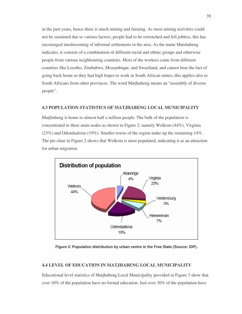
39
in the past years, hence there is much mining and farming. As most mining activities could
not be sustained due to various factors, people had to be retrenched and left jobless, this has
encouraged mushrooming of informal settlements in the area. As the name Matshabeng
indicates, it consists of a combination of different racial and ethnic groups and otherwise
people from various neighbouring countries. Most of the workers come from different
countries like Lesotho, Zimbabwe, Mozambique, and Swaziland, and cannot bear the fact of
going back home as they had high hopes to work in South African mines; this applies also to
South Africans from other provinces. The word Matjhabeng means an “assembly of diverse
people”.
4.3 POPULATION STATISTICS OF MATJHABENG LOCAL MUNICIPALITY
Matjhabeng is home to almost half a million people. The bulk of the population is
concentrated in three main nodes as shown in Figure 2, namely Welkom (44%), Virginia
(23%) and Odendaalsrus (19%). Smaller towns of the region make up the remaining 14%.
The pie chart in Figure 2 shows that Welkom is most populated, indicating it as an attraction
for urban migration.
Figure 2: Population distribution by urban centre in the Free State (Source: IDP).
4.4 LEVEL OF EDUCATION IN MATJHABENG LOCAL MUNICIPALITY
Educational level statistics of Matjhabeng Local Municipality provided in Figure 3 show that
over 10% of the population have no formal education. Just over 30% of the population have

40
primary education and about 35% have secondary education. Less than 5% of the population
have tertiary and other higher education.
Figure 3: Level of education in Matjhabeng Local Municipality.
The low literacy and very low skills level education rate are indicative of the neglect of the
majority of the population with respect to education. This correlates with the household
income levels provided in Figure 4 with the majority of household in the low to no income
region and a small number with comparatively high income.
02,0004,0006,0008,000
10,00012,00014,00016,000
Num
ber o
f Ho
useh
olds
None R6001-12000
R30001-42000
R72001-96000
R192001-360000
NA
Income Category
Annual Houshold Income
Figure 4: Annual household income levels (Source: IDP).
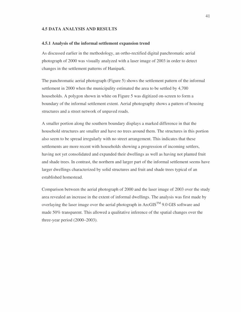
41
4.5 DATA ANALYSIS AND RESULTS
4.5.1 Analysis of the informal settlement expansion trend
As discussed earlier in the methodology, an ortho-rectified digital panchromatic aerial
photograph of 2000 was visually analyzed with a laser image of 2003 in order to detect
changes in the settlement patterns of Hanipark.
The panchromatic aerial photograph (Figure 5) shows the settlement pattern of the informal
settlement in 2000 when the municipality estimated the area to be settled by 4,700
households. A polygon shown in white on Figure 5 was digitized on-screen to form a
boundary of the informal settlement extent. Aerial photography shows a pattern of housing
structures and a street network of unpaved roads.
A smaller portion along the southern boundary displays a marked difference in that the
household structures are smaller and have no trees around them. The structures in this portion
also seem to be spread irregularly with no street arrangement. This indicates that these
settlements are more recent with households showing a progression of incoming settlers,
having not yet consolidated and expanded their dwellings as well as having not planted fruit
and shade trees. In contrast, the northern and larger part of the informal settlement seems have
larger dwellings characterized by solid structures and fruit and shade trees typical of an
established homestead.
Comparison between the aerial photograph of 2000 and the laser image of 2003 over the study
area revealed an increase in the extent of informal dwellings. The analysis was first made by
overlaying the laser image over the aerial photograph in ArcGISTM 9.0 GIS software and
made 50% transparent. This allowed a qualitative inference of the spatial changes over the
three-year period (2000–2003).

42
Figure 5: An ortho-rectified aerial photograph showing the Hanipark informal settlement in 2000. Note a recently settled portion in the south-west.

43
A new boundary marking the extent of the Hanipark informal settlement as inferred from the
2003 laser image was digitized on-screen as a polygon. Figure 6 shows the 2003 laser image
overlain with the 2000 (white) and 2003 (red) informal settlement boundary polygons. The
two lines shown in Figure 6 show a significant increase in the spatial extent of the informal
settlement between the two dates. Between 2000 and 2003, informal dwellings were
established along the eastern boundary marked by a tarred main road and by a cadastral
boundary in the west.
The area extent of Hanipark informal settlement as inferred from the 2000 aerial photograph
was calculated in the ArcGISTM 9.0 from the digitized polygon at 137.1655 ha. The area
extend based on the 2003 laser image was similarly calculated at 147.2986 ha, indicating an
increase in informal settlement area of 10.1331 ha. The increased settlement area corresponds
with trend demonstrated by an estimated increase of 1,021 household dwellings (from 4,700
in 2000 to 5,721 in 2005).
4.5.2 Spatial manifestation of conventional planning failure
The Matjhabeng Local Municipality in its IDP adopted a business plan for upgrading
Hanipark into a formal township through the following activities:
• Planning, surveying, and opening a township register
• Provision of bulk municipal services
• Provision of rudimentary internal municipal services
The 2006/07 progress report indicated that a layout plan had been completed and pegging
which is a last step towards establishing a township register after surveying of individual
stands or parcels was 50% complete.
Bulk water supply was completed in 2004 with 12 km of water lines at an average walking
distance for resident of 100 m. A main storm water draining system to allow the construction
of internal roads was also completed in 2004. The report also stated that a new clinic was
under construction and was 70% complete.
In view of the reported achievements, it cannot be maintained that planning for the upgrade of
Hanipark informal settlement has failed. However, there is evidence of enormous challenges
mainly due to the “top down” conventional planning approaches. Although the community is

44
consulted by municipal planners as stipulated in the IDP, there is no practical participation in
planning at all levels but rather some kind of community involvement in form of public
comment on the plans and implementation through employment in construction activities.
Community involvement is mainly left to contractors who in the case of Hanipark bulk water
provision employed a “community liaison officer” elected by the community. This seems to
be common practice as “the community liaison officer” features in budget items of IDP
projects.
The current planning and implementation of informal settlement upgrading approaches seem
to be inadequate and unsustainable according to best practice discussed in the literature
review. One of the problems of “top down” layout planning as opposed to that driven by
residents and other stakeholders of the informal settlement is the continuous inflow of new
settlers as demonstrated by the mapped change in spatial extent as shown in Figure 6.
The other problem of “top down” layout planning is that settlers usually do not respect them,
either because they cannot wait for the layout planning process to be completed, because they
are not convinced of relocating to in conformance with the layout plan if they are already
settled or because new settlers have established dwellings oblivious of the layout plan.
The problem of unmatched layouts plans to settlements is clearly demonstrated in Figure 7,
where the layout plan map is overlaid on the laser image of 2003. As can be seen in Figure 7,
the layout plan is not related to the settlement reality on the ground. Road reserves, open
spaces and community service amenities such as schools and clinics shown in the layout plan
have all been filled by settlement structures ranging from reasonably good houses to
makeshift shacks.
The planning programme for in-situ upgrading the Hanipark informal settlement speaks of
relocations to give effect for the layout plan. It is however doubtful whether the relocation
will be successful given the “top down” approach. In the next chapter, a more consultative
and participatory approach based on the UN-HABITAT (2004) best practice is proposed for
the upgrade of Hanipark and other informal settlements with similar characteristics in South
Africa.

45
Figure 6: Boundary polygons based on 2000 air photo (white) and 2003 (red) against the laser image backdrop showing the increased area extent.

46
Figure 7: Layout plan for Hanipark as prepared by municipal planners; old and new area extents overlaid on the laser image of 2003.

47
47
4.5.3 Key informant interviews
Key informants composed of stakeholder representatives in the Hanipark upgrade planning
were identified and interviewed in order to gain insight on causes of the migration and the
priority needs that determine the location of settlement. Questions asked to the Key
Informants and the responses obtained are provided in the appendix. Table 4 shows a list of
Key Informants interviewed and their respective stakeholder affiliations:
Table 4: Details of Key Informants and their respective affiliations as stakeholders.
Name of Key Informant Type of Stakeholder
Affiliation Position
Ivy Mavuso Local Authority
Matjabeng Local Municipality
Director (Local Development and Housing)
Moses Leemisa Private Sector
Laubsher, Slabbert and Brinks (Pty) Ltd
Engineer
Monkoe Mamaregane Govt Dept DLA Principal Planner
Vuyani Mnyamane NGO (Free State Rural Development Association)
Rural Development Advisor
Motlogelwa Mautse CBO Community Feeding Scheme
Community Facilitator
4.5.4 Origin of Hanipark settlers
The interviews revealed that most of the residents of Hanipark came from the neighbouring
Thabong informal settlement as so-called “backyard” tenants who squatted within the
compound or parcels that were allocated to earlier arrivals. Thabong was attempting to
undergo in-situ upgrade hence the evictions of the backyard (late comer) tenants in the so-
called “operation clean out”. A large number of settlers were evicted from commercial
farms, where they had been farm labourers with skills including farm equipment operation,
packaging and loading as well as crop and livestock care. Many settlers came from
neighbouring towns while others came from neighbouring countries the majority of whom
are former migrant workers retrenched by local gold mines.

48
48
4.5.5 Priority needs of Hanipark settlers
Key informants revealed that priority needs that Hanipark settlers sought included housing
and proper roads; electricity, water and sanitation; health clinics and schools.

49
49
CHAPTER 5: CONCLUSION AND RECOMMENDATION
This research has revealed that conventional urban planning currently practiced as a “top
down” approach has not succeeded in resettling migrants with security of land tenure and
basic municipal services. The research has shown a continuous in-flow of settlers, mainly
evictees and retrenched workers from commercial farms and mines that seem to be
oblivious of the planning processes making it impossible to implement the plans. The
research hypothesis that the failure of the upgrade is due to lack of community
participation was validated by the clear contradiction between the plans and the actual
settlement patterns revealed in the image and layout plan analysis. The analysis showed
that settler set up homes and continue to do so independent of the developed plans showing
a lack of cooperation, conscious or otherwise.
Current best practices advocate that stakeholder driven participatory planning approaches
are more successful in sustainable upgrade of informal settlements in-situ. The stakeholder
driven approach for in-situ upgrading of informal settlements emphasizes the identification
of all stakeholders and the creation of a stakeholder forum composed of representatives of
the respective stakeholders including those of the informal dwellers, local and national
government departments and agencies, NGO, CBOs and the private sector. The
stakeholder forum then drives the entire in-situ upgrading process in collaboration with the
statutory mandated agencies for land and services delivery.
A phased stakeholder driven approach is recommended in Table 5, for the in-situ upgrade
of the Hanipark informal settlement based on the UN-HABITAT (2004) best practice. The
recommended procedure shown in Table 5 is characterized by three-phase each one with
specific functions, outputs and the implementer described.

50
50
Table 5: Proposed approach for upgrading Hanipark and similar informal settlements in-situ, based on UN-HABITAT (2004) best practice.
PHASE FUNCTIONS OUTPUTS IMPLEMENTER
Phase 1:
Identification of Stakeholders e.g. • Informal settlement reps (elected Councillors) • Reps from Govt Depts (Land Affairs, Local Govt and
Housing, Public Works, Health, Education, Social Dev)
• Political: ANC Constituency Office • Private sector: Sedibeng Water • NGOs • CBOs • Religious groups Creation of Stakeholder Forum
• Conduct a land audit (legal/ownership status of occupied lands)
• Identify policy instruments, resources and processes
• Secure partnerships with funding sources including private sector and community saving schemes
• Stakeholders Forum created • Participation • Clarified land ownership • Clarified policy instruments
(SLAG/IDP) for integration
Local Municipality
Phase 2:
Land Zoning and Establishing Tenure Framework • Create land use zones (Settlement, schools, Clinics,
roads and other infrastructure) • Negotiate boundaries • Record boundaries • Outline minimum planning requirements • Build capacity of those to do land administration
• Create and designate zones that allow special tenure and development appropriate for the poor
• Negotiate with land owners for legalizing tenure of zoned lands by sell, swap, share, lease or other creative methods (using SLAG/IDP funds)
• Land affected clearly identified for type of land use
• Improved security of land tenure for informal dwellers
• Increased capacity to manage the new land administration system
Stakeholder Forum
Phase 3:
Detailed Planning and Implementation • Defining infrastructure networks and funding sources • Participatory planning (relocation, connection, costs) • Upgrading land tenure • Reform land information systems and management • Clarifying private sector/NGOs roles in land delivery
• Securing tenure rights to land for families of informal settlement dwellers
• Implementing the land administration system that will record the upgraded rights
• Developing an integrated infrastructural plan with due consideration to sustainability in terms of long-term maintenance and affordability
• Upgraded tenure and services
• Appropriate land information system
• Integrated infrastructure plan • Participation • Lessons for reviewing legal
frameworks
Stakeholder Forum
and
Local Municipality

51
The first phase involves the establishment of a Stakeholder Forum whereby key
stakeholders (examples shown in Table 5) are identified and co-opted to form the forum. In
this phase the Stakeholder Forum then seeks and secures partnerships with stakeholder
entities that can contribute funding for some aspects of the upgrading. The Stakeholder
Forum also promotes community saving schemes to enable dwellers to pay for some
services which in turn provides a sense of ownership.
Phase 2 involves the creation of re-designation of land into zones for settled and for social
amenities such as schools, clinics, roads and other infrastructure. The main function of the
zoning is to allow special tenure and development arrangements appropriate for the poor.
The Stakeholder Forum pursues and reaches negotiated arrangements for sell, swap,
sharing or lease of land with owners using the identified funding mechanisms that would
have been identified in Phase 1. Specific outcomes of Phase 2 include clear land zones
designated for specific uses, improved land tenure security for dwellers and increased
capacity to manage the newly designed land administration system.
Phase 3 involves detailed participatory planning lead by the Stakeholder Forum for an
integrated infrastructural plan with sustainability features regarding affordability of
services by the poor residents as well as long-term maintenance. This phase also involves
the implementation of the negotiated tenure arrangements and the newly adopted land
administration system for recording the upgraded land rights. One of the important
outcomes recommended in this best practice method, is the use of the lessons learned to
review prevailing legal frameworks.
It is envisaged that the proposed Stakeholders driven upgrading approach is bound to be
more successful as the residents are actively participating in the planning and
implementation. Active participation ensures that no newcomers to continue settle on land
designated for other use or where tenure rights have been secured for other families, a main
problem for in-situ upgrading. Greater participation also ensures a more complete
infrastructural network for service provision and affordability as well as long-term
maintenance essential for sustainability.

52
REFERENCES
ABBOTT, J. 1996. Sharing the City: Community Participation in Urban Management. London: Earthscan Publications Ltd. ISBN 1-85383-323-1.
ABBOTT, J. 2000. Upgrading Informal Settlements for integration into the formal city. Conference on Formal and the Informal City – What Happens at the Interface? The Nordic Africa Institute, Uppsala, Centre for Development Research, Copenhagen and the Department of Human Settlements, Copenhagen in Copenhagen, Denmark, 15–18 June 2000.
ABBOTT, J. 2001. The use of Spatial Data to Support the Integration of Informal Settlements into the Formal City. International Journal of Applied Earth Observation and Geoinformation 3 (3): 267–277.
ABBOTT, J. 2002a. An Analysis Of Informal Settlement Upgrading And Critique Of Existing Methodological Approaches. Habitat International 26 (3): 303–315.
ABBOTT, J. 2002b. The Development Of A Generic Integrated Approach To Informal Settlement Upgrading. Habitat International 26 (3): 317–333.
ABBOTT, J. and DOUGLAS, D. 2001. A Methodological Approach to the Upgrading, InSitu, of Informal Settlements In South Africa. Pretoria: Water Research Commission. WRC Report No 786/2/01. ISBN 1 86845 796 6.
ALFONSIN, B. 1999. Instruments, Experiences and Trends in Tenure Regularization in Brazil. Paper presented at “Tenure Security Policies in South African, Brazilian, Indian and Sub-Saharan African Cities: A Comparative Analysis”, Centre of Applied Legal Studies, 27–28 July 1999, Johannesburg.
AZUELA, A. and DUHAU, E. 1998. Tenure Regularization, Private Property and Public Order in Mexico. In: E. Fernandes and A.Varley (eds.), Illegal Cities: Law and Urban Change in Developing Countries. Zed Books, London.
BANERJEE, B. 1999a. The role of researchers and practitioners in setting up a concerted urban management approach: lessons from South Asian municipalities. Paper presented at N-aerus International workshop on Concepts and Paradigms of Urban Management in the Context of Developing Countries, Venice, 11–12 March 1999
BANERJEE, B.1999b. Security of Tenure in Indian Cities: Overview of Policy and Practice. Paper presented at “Tenure Security Policies in South African, Brazilian, Indian and Sub-Saharan African Cities: A Comparative Analysis”, Centre of Applied Legal Studies, 27–28 July 1999, Johannesburg.
BEAVON, K.S.O. 1989. Mexico City and Colonias Populares: hints for a South African squatter policy. South African Geographical Journal 71: 142-156.
BERNSTEIN, A. 1989. Focus on the cities: towards a new national agenda. Africa Insight 19: 65-71.
BEUKMAN R. 1999. Land Rights and the Environment: Issues in “urban” settlements in the Former Homelands of South Africa. Paper presented at the International Conference, “South to South: urban-environmental policies and politics in Brazil and South Africa” Institute of Commonwealth Studies, London 25–26 March 1999.
CHRISTENSEN, S.F., WOLFGANG, W. and HOJGAARD, P.D. 1999. Innovative Land Surveying and Land Registration in Namibia. The Development Planning Unit, University College, London.
DAVIES, C. and FOURIE, C. 1999. A land management approach for informal settlement in South Africa. Paper presented at “Tenure Security Policies in South African, Brazilian, Indian and Sub-Saharan African Cities: A Comparative Analysis”, Centre of Applied Legal Studies, 27–28 July 1999, Johannesburg.
DE BEER, F. 1989. Informal settlements in African cities. Africa Insight 19: 72-81.

53
DE CASTRO, S. 1999b. Favela Bairro Programme: A brief institutional analysis of its land aspects. Paper presented at “Tenure Security Policies in South African, Brazilian, Indian and Sub-Saharan African Cities: A Comparative Analysis”, Centre of Applied Legal Studies, 27–28 July 1999, Johannesburg.
DIACON, D. 1997. Slum Networking. An Innovative Approach to Urban Development, Building and Social Housing. Foundation, London.
DURAND LASSERVE, A. 1998. Trends and Issues. In: E. Fernandes and A. Varley (eds.), Illegal Cities: Law and Urban Change in Developing Countries. Zed Books, London.
EL-BATRAN, M. 1999a. Tenure Upgrading and Security of Tenure Policies in the Cairo Metropolitan Region. Paper presented at “Tenure Security Policies in South African, Brazilian, Indian and Sub-Saharan African Cities: A Comparative Analysis”, Centre of Applied Legal Studies, 27–28 July 1999, Johannesburg.
EL-BATRAN, M. 1999b. The Egyptian Experience of redefining property rights in the age of liberalization and privatization: a review. Paper presented at “Law and Urban Space – Facing the paradox: Redefining Property Rights in the age of Liberalisation and Privatisation”, International Research Group on Law and Urban Space (IRGLUS), and Centre for Applied Legal Studies (CALS), Johannesburg, South Africa, 29–30 July 1999.
INTERNATIONAL FEDERATION OF SURVEYORS FIG Commission 3. 2002. Land Information Management for Sustainable Development of Cities. Best Practice Guidelines in City-wide Land Information Management. FIG. PUBLICATION 31.
GAUTENG DEPARTMENT OF DEVELOPMENT PLANNING AND LOCAL GOVERNMENT. 1998. Gauteng urbanisation trends status quo investigation. Gauteng Department of Development Planning and Local Government, Johannesburg.
HARRISON, B. 1994. Lean and Mean: The Changing Landscape for Corporate Power in the Age of Flexibility. New York: Basic Books, Inc.
HARRISON, P. 1992. The policies and politics of informal settlement in South Africa: a historical perspective. Africa Insight 22: 14-22.
HENDLER, P. 1991. The housing crisis. In: M. Swilling, R. Humphries and K. Shubane (eds.), The apartheid city in transition. Oxford University Press, Cape Town.
HUCHZERMEYER, M. 1999. Tenure questions as understood in the debates in South African informal settlement and intervention literature of the 1990s – a critical review. Paper presented at “Tenure Security Policies in South African, Brazilian, Indian and Sub-Saharan African Cities: A Comparative Analysis”, Centre of Applied Legal Studies, 27–28 July 1999, Johannesburg.
HUCHZERMEYER, M. 1999. The exploration of appropriate informal settlement intervention in South Africa: Contributions from a comparison with Brazil. Ph.D. thesis (unpublished), University of Cape Town, South Africa.
HUCHZERMEYER, M. 2003. A legacy of control? The capital subsidy and informal settlement intervention in South Africa. International Journal of Urban and Regional Research 27 (3): 591–612.
LI, J., MASON, S. and RÜTHER, H. 1997. Experiences in automated shack extraction using multispectral image classification. Proceedings of CONSAS’97, 24–28 August 1997, Durban.
LI, J., MASON, S. and RÜTHER, H. 1998. Multiple cue fusion in GIS for shack extraction from digital small format imagery. Department of Geomatics, University of Cape Town.
LU, D., MAUSEL, P., BRONDIZIO, E. and MORAN, E. 2004. Change detection techniques. International Journal of Remote Sensing 25 (12): 2365–2407.
MACOLOO, G.C. 1996. The interaction between urbanisation and housing policies in Kenya: any lessons for South Africa? In: R.J. Davies (ed.), Contemporary City Structuring, International Geographical Insights. International Geographical Union Commission on Urban Development and Urban Life, Cape Town.
MACOLOO, G.C. 1998. The relevance of Kenya’s urban settlement policies for independent South Africa. South African Geographical Journal 80: 81-85.
MARAIS, L. 1997. Botshabelo’s changing housing landscape. Africa Insight 27: 171-177.

54
MAZUR, RE and QANGULE, V.N. 1995. African Migration and Appropriate Housing Responses in Metropolitan Cape Town. Western Cape Community-based Housing Trust, Draft Report.
MCCARTHY, J. and BERNSTEIN, A. 1996. Durban – South Africa’s global competitor? Big Cities Series, Centre for Development and Enterprise, Johannesburg.
METROPOLITAN SPATIAL DEVELOPMENT FRAMEWORK: A GUIDE FOR SPATIAL DEVELOPMENT IN THE CAPE METROPOLITAN REGION. 1995. Draft for Discussion. Western Cape Economic Development Forum, Urban Development Commission.
PAYNE, G. 1991. Urban Land Tenure and Property Rights in Developing Countries. A Review. ODA Publication.
PARNELL, S. 1997. South African cities from the ivory tower of urban studies. Urban Studies 34 (5-6): 891-906.
PILLAY, U. 1995. The spontaneous settlement question in South Africa: insights from international experience. South African Geographical Journal 77: 45-50.
ROGERSON, C.M. 1989a. Managing the decolonizing city in southern Africa, South African Geographical Journal 71: 201-208.
ROGERSON, C.M. 1989b. Malaysian urbanization: policy lessons for South Africa. South African Geographical Journal 71: 174-181.
SAPIRE, H. 1992. Politics and Protest in Shack Settlements of the Pretoria–Witwatersrand–Vereeniging Region, South Africa, 1980–1990. Journal of Southern African Studies 18: 670-697.
SEFATLHE, M.N. 1998. Informal settlements summit charts the way forward, Houses for Gauteng. Official newspaper of the Department of Housing and Land Affairs, Issue 2, Johannesburg.
SAFF, G. 1996. Claiming a Space in a Changing South Africa: The “Squatters” of Marconi Beam, Cape Town. Annals of the Association of American Geographers. Blackwell, Cambridge, Massachusetts.
STEVENS, L. and RULE, S. 1997. Upgrading Gauteng’s informal settlements Volume 1: a baseline study of Eatonside and Albertina (Etwatwa extension 30). Community Agency for Social Enquiry, Johannesburg.
STEVENS, L. and RULE, S. 1998. Upgrading Gauteng’s informal settlements Volume 2: a baseline study of Soshanguve South Ext. 4 and Johandeo. Community Agency for Social Enquiry, Johannesburg.
STEVENS, L., MARSHALL, S., MORRISON, M. and RULE, S. 1998. Upgrading Gauteng’s informal settlements Volume 3: First follow-up surveys at Eatonside, Albertina, Soshanguve South Ext. 4 and Johandeo. Community Agency for Social Enquiry, Johannesburg.
PARNELL, S. 1997. Changes in the Racial Division of Labour During the Apartheid Era. Journal of Southern African Studies 22(4): 633-656.
SOUTH AFRICA DEPARTMENT OF HOUSING, 1994. White paper. A new housing policy and strategy for South Africa, Department of Housing, Pretoria.
SOUTH AFRICAN DEPARTMENT OF LAND AFFAIRS. 1998. White Paper on South African Land Policy, April 1997. ISBN 0-621-273-42-2 Government Printer, Pretoria.
SOUTH AFRICAN INSTITUTE OF RACE RELATIONS. 1994. Race Relations Survey 1993/1994. Johannesburg, South African Institute of Race Relations.
SOUTH AFRICAN INSTITUTE OF RACE RELATIONS. 1996. South Africa Survey 1995/1996. Johannesburg, South African Institute of Race Relations.
THE SATURDAY STAR, 21/2/98, Johannesburg.
THIRKELL, A.J. 1996. Players in urban informal land markets; who wins? who loses? A case study of Cebu City. Environment and Urbanization 8 (2): 71-90.
TOMLINSON, M.R. 1998. South Africa’s New Housing Policy: An Assessment of the First Two Years, 1994–96. International Journal of Urban and Regional Research 22: 137-146.
TOMLINSON, R. 1988. South Africa’s Urban Policy: A New Form of Influx Control. Urban Affairs Quarterly 23: 487-510.

55
UNCHS (Habitat). 1996. Urban poverty: A world challenge – The recife declaration, March 1996. Habitat II, Recife International Meeting on Urban Poverty, Recife, Brazil, 17–21 March 1996.
UNCHS. 1997. Indicators Programme, UNCHS (Habitat) 20 September 1997. United Nations Centre for Human Settlement, 1999.
UNITED NATIONS CENTER FOR HUMAN SETTLEMENT (HABITAT). 1998. Informal Settlements, Security of Tenure, Urban Land Management and Local Governance, Experiences in Implementing the Habitat Agenda, Land management Series No. 7 (Draft version: Nairobi, June 1998).
UNITED NATIONS CENTRE FOR HUMAN SETTLEMENT (HABITAT). 1996b. New Delhi Declaration, Global conference on access to land and security of tenure as a condition for sustainable shelter and urban development. New Delhi, 17–19 January 1996. Preparation document for Habitat II, Istanbul.
UNITED NATIONS HUMAN SETTLEMENT PROGRAMME (UN-HABITAT). 2004. Pro poor land management. Integrating slums into city planning. UN_HABITAT, Nairobi.
URBAN PROBLEMS RESEARCH UNIT. 1990. An Overview of Development Problems in the Cape Town Metropolitan Area. Working Paper No 40, University of Cape Town.
VARLEY, A. 1999. New models of urban land regularisation in Mexico: Decentralisation and democracy vs. clientilism. Paper presented at N-aerus International workshop on Concepts and Paradigms of Urban Management in the Context of Developing Countries, Venice, 11–12 March 1999.
YOUSRY, M. and ABOUL ATTA, T.A. 1997. The challenge of urban growth in Cairo. In: C. Rakodi (ed.), The Urban Challenge in Africa: growth and management of its large cities. United Nations University Press, Tokyo.
INTERNET SITES:
www.unhabitat.org/pmss/getElectronicVersion.asp?nr=2133&alt=1. Law, Land Tenure and Gender Review Series: Southern Africa United Nations Human Settlements Programme (UN-HABITAT), 2005 ISBN Number (Series): 92-1-131768-1 [Access date 29 September 2005]
www.bestpractices.org. 1999. An Urbanizing World: Global Report on Human Settlements 1996 (Executive Summary) ISBN: 92-1-131309-0 [Access date 20 November 2005]
www.gisdevelopment.net/proceedings/gisdeco/sessions/abbottpf.htm. The use of GIS in informal settlement upgrading: Its role and impact on the community and on local government [Access date 10 March 2006]
www.unchs.org. An Urbanizing World: Global Report on Human Settlements 1996 (Executive Summary) ISBN: 92-1-131309-0 [Access date 29 September 2005
www.fig.net/commission3/publications/publication_index.htm. INTERNATIONAL FEDERATION OF SURVEYORS; FIG Commission 3 – Spatial Information Management in co-operation with the UN-HABITAT. [Access date 10 April 2006]
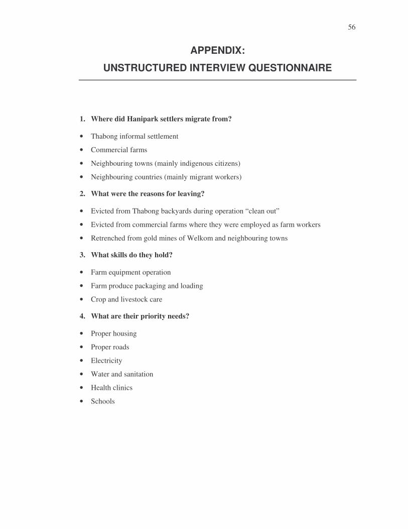
56
APPENDIX:
UNSTRUCTURED INTERVIEW QUESTIONNAIRE
1. Where did Hanipark settlers migrate from?
• Thabong informal settlement
• Commercial farms
• Neighbouring towns (mainly indigenous citizens)
• Neighbouring countries (mainly migrant workers)
2. What were the reasons for leaving?
• Evicted from Thabong backyards during operation “clean out”
• Evicted from commercial farms where they were employed as farm workers
• Retrenched from gold mines of Welkom and neighbouring towns
3. What skills do they hold?
• Farm equipment operation
• Farm produce packaging and loading
• Crop and livestock care
4. What are their priority needs?
• Proper housing
• Proper roads
• Electricity
• Water and sanitation
• Health clinics
• Schools