I. INTRODUCTION - ICRISAT the Hyderabad-Kalvakurthi State Highway and then travel a further distance...
8
IMOD Innovate Grow Prosper I. INTRODUCTION In 1975, the Socioeconomics Program of the International Crops Research Institute for the Semi-Arid Tropics (ICRISAT) initiated Village-Level Studies (VLS) at six locations in India. Aurepalle, in Mahbubnagar District of Andhra Pradesh, is one of the villages selected under the project for conducting multidisciplinary research by agrobiological and social scientists in a real farm situation. The information gathered from these studies has helped generate and transfer appropriate technologies that are feasible and acceptable to the farmers. Aurepalle (16° 51 ’ N 78° 37 ’ E) is situated in Madgul mandal in Mahbubnagar District (16° 73 ’ N and 77° 98 ’ E) in the Telangana Region of Andhra Pradesh. Mahbubnagar is named in honor of Mir Mahbub Ali Khan Asaf Jah VI, the Nizam of Hyderabad (1869-1911 AD). Mahbubnagar district became independent and joined the democratic state of India on 18 September 1948. To reach Aurepalle, one needs to travel to Amangal town, which is about 60 km from Hyderabad on the Hyderabad-Kalvakurthi State Highway and then travel a further distance of 10 km East on a tar road. Autorickshaws and Road Transport Corporation buses are the main means of transportation between Aurepalle and Amangal. Aurepalle represents a region with medium to shallow alfisols and an annual rainfall of about 700 mm, distributed erratically. Soil depth ranges from 15 to 45 cm. Cotton, paddy, sorghum, pearl millet, castor and pigeonpea are the major crops cultivated in the village.
Transcript of I. INTRODUCTION - ICRISAT the Hyderabad-Kalvakurthi State Highway and then travel a further distance...

IMODInnovate Grow Prosper
I. INTRODUCTIONIn 1975, the Socioeconomics Program of the International Crops Research Institute for the Semi-Arid Tropics (ICRISAT) initiated Village-Level Studies (VLS) at six locations in India. Aurepalle, in Mahbubnagar District of Andhra Pradesh, is one of the villages selected under the project for conducting multidisciplinary research by agrobiological and social scientists in a real farm situation. The information gathered from these studies has helped generate and transfer appropriate technologies that are feasible and acceptable to the farmers.
Aurepalle (16° 51’ N 78° 37’ E) is situated in Madgul mandal in Mahbubnagar District (16° 73’ N and 77° 98’ E) in the Telangana Region of Andhra Pradesh.
Mahbubnagar is named in honor of Mir Mahbub Ali Khan Asaf Jah VI, the Nizam of Hyderabad (1869-1911 AD). Mahbubnagar district became independent and joined the democratic state of India on 18 September 1948. To reach Aurepalle, one needs to travel to Amangal town, which is about 60 km from Hyderabad on the Hyderabad-Kalvakurthi State Highway and then travel a further distance of 10 km East on a tar road. Autorickshaws and Road Transport Corporation buses are the main means of transportation between Aurepalle and Amangal. Aurepalle represents a region with medium to shallow alfisols and an annual rainfall of about 700 mm, distributed erratically. Soil depth ranges from 15 to 45 cm. Cotton, paddy, sorghum, pearl millet, castor and pigeonpea are the major crops cultivated in the village.
Aurepalle Village at a Glance2
II. HISTORICAL BACKGROUND / DEVELOPMENT OF THE VILLAGEDuring the last three decades, Aurepalle village has progressed to varying degrees in terms of social, political, economic, technological, institutional and infrastructural, educational, and religious advancement.
Social: Households in the village belong to five different caste groups based on the social progression, namely, forward caste (FC), backward caste (BC), scheduled caste (SC), scheduled tribe (ST) and minorities. Each of these groups has many castes. As many as 23 castes exist in the village, among which Brahmin, Reddy, Vysya and Velama belong to FC and are generally richer and more influential. People whose caste/traditional occupations are carpentry (Wadla), weaving (Padmasali), gold and silver work (Amsali), hair cutting (Mangali), washing clothes (Chakali), sheep rearing (Kurma), toddy tapping (Gowda), butcher (Katika) and pottery (Kummari), belong to BC. Households belonging to Mala and Madiga (SC or harijans) are ranked lowest in the social hierarchy and most of the labor force (70 percent) working in the fields belong to these two castes. Some of the caste occupations, such as bogama (dancers), weaver, cobbler, pot maker, telaga (fishmonger) and goldsmith, have lost their standing over time due to low demand for their services/products.
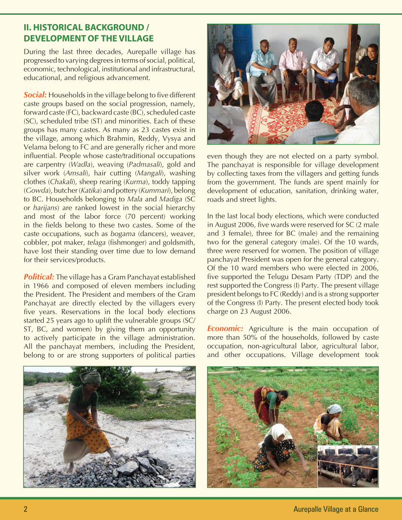
Political: The village has a Gram Panchayat established in 1966 and composed of eleven members including the President. The President and members of the Gram Panchayat are directly elected by the villagers every five years. Reservations in the local body elections started 25 years ago to uplift the vulnerable groups (SC/ST, BC, and women) by giving them an opportunity to actively participate in the village administration. All the panchayat members, including the President, belong to or are strong supporters of political parties
even though they are not elected on a party symbol. The panchayat is responsible for village development by collecting taxes from the villagers and getting funds from the government. The funds are spent mainly for development of education, sanitation, drinking water, roads and street lights.
In the last local body elections, which were conducted in August 2006, five wards were reserved for SC (2 male and 3 female), three for BC (male) and the remaining two for the general category (male). Of the 10 wards, three were reserved for women. The position of village panchayat President was open for the general category. Of the 10 ward members who were elected in 2006, five supported the Telugu Desam Party (TDP) and the rest supported the Congress (I) Party. The present village president belongs to FC (Reddy) and is a strong supporter of the Congress (I) Party. The present elected body took charge on 23 August 2006.
Economic: Agriculture is the main occupation of more than 50% of the households, followed by caste occupation, non-agricultural labor, agricultural labor, and other occupations. Village development took
Aurepalle Village at a Glance 3
place through diversification in both farm and non-farm sectors, generally supported by government development programs. Presently, each household has two or more sources of income from crop, farm and non-farm labor, business, migration, caste occupation, monthly salary, and livestock rearing. Household incomes were enhanced by diversification to high-value crops, investment in livestock (especially sheep, goat and milch animals), and shift from nonprofitable caste occupations to non-farm activities and emigration.
The households’ income and welfare improved due to adoption of new crop production technologies, cultivation of commercial crops, drilling of successful borewells, emigration for non-farm activities, caste occupations (toddy sale, sheep rearing), milk sale, hard work and discipline. Education levels improved, enabling the households to obtain and understand information about new technologies as well as to get salaried jobs. The village harnessed improved access to roads, markets and communication media. Most significantly, the establishment of the international airport at Shamshabad and other industries within a distance of 40-50 km from the village has driven socioeconomic change. Due to this industrialization, the land values in Aurepalle have shot up almost ten times. Health conditions have also improved due to better availability of medical facilities within the village and the nearby town, improvement in sanitation, and supply of protected drinking water.
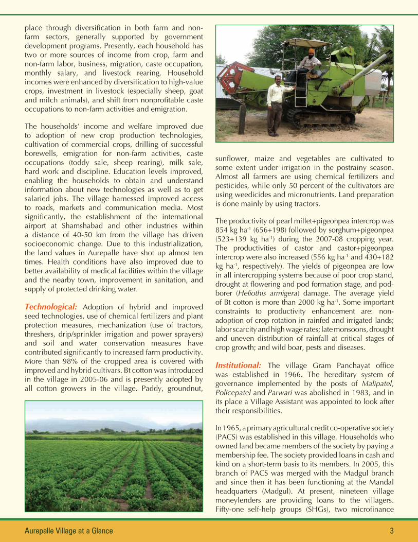
Technological: Adoption of hybrid and improved seed technologies, use of chemical fertilizers and plant protection measures, mechanization (use of tractors, threshers, drip/sprinkler irrigation and power sprayers) and soil and water conservation measures have contributed significantly to increased farm productivity. More than 98% of the cropped area is covered with improved and hybrid cultivars. Bt cotton was introduced in the village in 2005-06 and is presently adopted by all cotton growers in the village. Paddy, groundnut,
sunflower, maize and vegetables are cultivated to some extent under irrigation in the postrainy season. Almost all farmers are using chemical fertilizers and pesticides, while only 50 percent of the cultivators are using weedicides and micronutrients. Land preparation is done mainly by using tractors.
The productivity of pearl millet+pigeonpea intercrop was 854 kg ha-1 (656+198) followed by sorghum+pigeonpea (523+139 kg ha-1) during the 2007-08 cropping year. The productivities of castor and castor+pigeonpea intercrop were also increased (556 kg ha-1 and 430+182 kg ha-1, respectively). The yields of pigeonpea are low in all intercropping systems because of poor crop stand, drought at flowering and pod formation stage, and pod-borer (Heliothis armigera) damage. The average yield of Bt cotton is more than 2000 kg ha-1. Some important constraints to productivity enhancement are: non-adoption of crop rotation in rainfed and irrigated lands; labor scarcity and high wage rates; late monsoons, drought and uneven distribution of rainfall at critical stages of crop growth; and wild boar, pests and diseases.
Institutional: The village Gram Panchayat office was established in 1966. The hereditary system of governance implemented by the posts of Malipatel, Policepatel and Parwari was abolished in 1983, and in its place a Village Assistant was appointed to look after their responsibilities.
In 1965, a primary agricultural credit co-operative society (PACS) was established in this village. Households who owned land became members of the society by paying a membership fee. The society provided loans in cash and kind on a short-term basis to its members. In 2005, this branch of PACS was merged with the Madgul branch and since then it has been functioning at the Mandal headquarters (Madgul). At present, nineteen village moneylenders are providing loans to the villagers. Fifty-one self-help groups (SHGs), two microfinance

Aurepalle Village at a Glance4
institutions, and two commercial banks (State Bank of India and Grameena Bank) form the major sources of credit for the villagers.
An integrated co-operative milk society, established in the 1970s, has been encouraging dairy farming in the village. Four private milk collection centers are also functioning in the village, which collect 1200-1500 liters of milk every day from the villagers.
Infrastructural: The village was electrified in 1962, and all households have access to electricity. It is mainly used for street lights and domestic use. Almost all households (980 households) have access to electricity including 8 commercial and 215 agricultural connections. A tar road was constructed in 2003 from Madgul to Amangal, passing through Aurepalle village. Marketing infrastructure, namely, roads, communication, and transport, has improved significantly over time. More than 700 cell phones and 8 public telephone booths operate in the village.
Between 1998 and 2002, three overhead tanks were constructed by the Gram Panchayat with government funding. These tanks supply purified drinking water through a pipeline to households and schools. About 576 households access drinking water through tap connections, while the remainder obtains it from 12 public hand pumps installed by the Gram Panchayat. During 2009, the village gained access to drinking water from the Krishna River, as an additional source. Presently, this is the main source of drinking water for the villagers, being supplied through nine water storage tanks. There are three overhead tanks that provide water for other purposes.
Construction of a veterinary hospital and village Gram Panchayat offices is currently in progress with financial assistance from the government. The village panchayat has taken up construction of earthen bunds on farmers’ fields irrespective of their caste. Under the Mahatma Gandhi National Rural Employment Guarantee Scheme (MGNREGS), the panchayat employed villagers had arranged for cutting of bushes (referred to as field cleaning or jungle clearance). The Gram Panchayat constructed two check dams and five water percolation tanks under the watershed program. One Auxiliary Nurse and Midwife (ANM) and two Registered Medical Practitioners (RMP) provide health services to the villagers.
Educational: An elementary school established in 1945 with a single teacher, was upgraded to Standard 4 with three teachers in 1951, and further upgraded to Standard 5 in 1991, Standard 6 in 1992, and so on until
the first batch of Standard 10 in 1996. Presently, there are three primary schools with an enrolment of 214 children (104 male and 110 female), two secondary schools with a strength of 100 children (52 male and 48 female) and one high school with an enrolment of 192 children (98 male and 94 female) in the village run by the government and private managements. Three Anganwadi centers are providing nutritive food, education and medical services to 43 male and 31 female children and 20 pregnant/lactating women. An Adult Education Program for people in the age group of 18-35 years is also functioning, but partially. Education levels and literacy rates of both male and female children have improved. The literacy rates have significantly increased to 90 percent in males and 70 percent in females, in the age group of 5-30 years.
Religious: Hindus form the largest religious group (968 households) in the village, followed by Muslims (15 households) and one Christian household. Religion plays an important role in the daily life of the villagers. Hindus mainly worship at the temple and their homes, while the Muslims go to Amangal every Friday to worship at the mosque. Hindu religious groups meet in the house of one of the farmers where they sing bhajansand listen to slokas under the guidance of a priest who performs pooja. There are four temples, of which one was constructed a long time ago in the center of the village—the Hindus perform pooja and bhajans here on Saturday nights and festivals.
Vinayaka Chathurthi, Dussera, Diwali, Sankranthi and Ugadi (Telugu new year) are important festivals for the Hindus. During certain festivals, especially Dussera, villagers participate in folk dances. A temple dedicated to goddess Pochamma, the protector from diseases, is situated two km east of Aurepalle. Every year in March, all villagers gather at this temple and perform pooja.

5Aurepalle Village at a Glance
III. BASIC STATISTICS OF THE VILLAGE
A) LOCATION / ACCESSIBILITY1. Village: Aurepalle 2. Mandal: Madgul 3. District: Mahbubnagar 4. State: Andhra Pradesh 5. PIN: 509 321
6. GPS values: (a) Latitude: 16° 51’ N (b) Longitude: 78° 37’ E (c) Altitude (m): 4567. Nearest town: (a) Name: Amangal (b) Distance from village (km): 108. Nearest State Highway: (a) Number: SH36 (b) Distance from village (km): 109. Nearest National Highway: (a) NH7 (b) Distance from village (km): 50
10. Name of the Village Panchayat in which the village falls: Aurepalle11. Details of the Sarpanch/Village Panchayat President:
(a) Name: E Lakshma Reddy (b) Cell No.: 0944142751312. Details of the Gram Sevak: (a) Name: K Jagmohan (b) Tel (Res): 08543-27761413. Details of the Village Revenue Officer (VRO):
(a) Name: L Yadgiri Rao (b) Tel (Res): 09441285158
B) DEMOGRAPHY (as on 31 December 2010)1. Population (No): 4764 2. Households (No): 9843. Voters (No): 2964 4. Farmer accounts/Khatas (No): 12735. Classification of population:Category No. Farm Size* No. Religion No. Caste No. Literacy No. Gender No.SC 1528 Landless 2153 Hindu 4693 Gowda 1057 Illiterate (<4) 1926 Male 2013ST 47 Marginal 1464 Muslim 67 Madiga 1028 Literate (4-10) 2383 Female 1949OBC 2801 Small 817 Christian 4 Kurma 644 Matriculate 420 Children 802Gen(FC) 388 Medium 238 Mala 495 Graduate 32
Large 92 Reddy 308 Postgraduate 3Vaddera 297Wadla 159Chakali 124Kummari 106Others# 546
Total 4764 4764 4764 4764 4764 4764*<0.1ha=Landless; 0.1-<1.0ha=Marginal; 1.0ha-<2ha=Small; 2-4ha=Medium; >4ha=Large. # includes 14 castes, namely, Brahmin, Vaisya, Velama, Boya, Gold Smith, Barber, Bogama, Padmasali, Mangali, Katika, Cobbler, etc.
6. Classification of households:Male headed (No): 844 Female headed (No): 140
Category No. Farm Size* No. Religion No. Caste No. Main occupation No.SC 292 Landless 147 Hindu 968 Gowda 238 Farming 500ST 11 Marginal 265 Muslim 15 Madiga 195 Caste occupation 157OBC 569 Small 372 Christian 1 Kurma 126 Non-agril. labor 155Gen (FC) 112 Medium 126 Mala 96 Agril. labor 130
Large 74 Reddy 71 Others$ 42Vaddera 61Wadla 33Chakali 27Kummari 19Others# 118
Total 984 984 984 984 984* and # As given under B(5).$ includes salaried, money lenders, middlemen, service sector, etc.

6 Aurepalle Village at a Glance
C) LAND USE PATTERN (2009-10)1. Distribution of Geographical Area: 2. Cropped Area
Particulars Ha Season Ha
Agricultural land 1265 Kharif 1186.2
Waste lands 32 Rabi 247.5
Land used for roads, buildings & non-agril. purposes 96 Annual/Perennial crops 49.0
Land occupied by water resources (tank, river) 8 Gross Cropped Area 1482.7
Land occupied by hills, rocks, etc. 227 3. Irrigated Area
Season Ha
Total Geographical Area 1628 Kharif 220.7
Rabi 239.8
Annual/Perennial crops 49.0
Gross Irrigated Area 509.5D) LAND RESOURCES1. Soil distribution 2. Irrigation sources (As on 31 December 2010)
Soil type % Area Source TotalNo.
WorkingNo.
Approx. depth (m)of working wells
Irrigated Area(Ha yr-1)
Red Soil 23 Borewells 250 232 60.1 486.0
Sandy Soil 28 Open wells 123 9 16.5 23.5
Shallow Black 15 Approx. land area covered (Ha)Gravelly Soil 19
Alkaline Soils 15 Tanks 2 0 6.5 0
3. Rainfall (Jun’09-May’10): (a) Quantity (mm/year): Normal: 972 Actual: 1546 (b) No. of rainy days: Normal: 45 Actual: 48
E) CROP PRODUCTION (2009-10)
Kharif Rabi Summer Annual/Perennial Crops
Crops Area (Ha) Crops Area (Ha) Crops Area (Ha) Crops Area (Ha)
Cotton 861.4 Paddy 126.4 Napier grass 27.9
Paddy 171.3 Groundnut 56.7 Mango 11.3
Castor+Pigeonpea 74.5 Sunflower 31.2 Citrus 9.8
Sorghum+Pigeonpea 31.2 Maize 14.2
Pigeonpea 15.4 Vegetables 11.3
Pearl millet+Pigeonpea 13.0 Horsegram 6.1
Maize 10.5 Safflower 1.6
Vegetables 8.9
Total 1186.2 247.5 0 49.0
7Aurepalle Village at a Glance
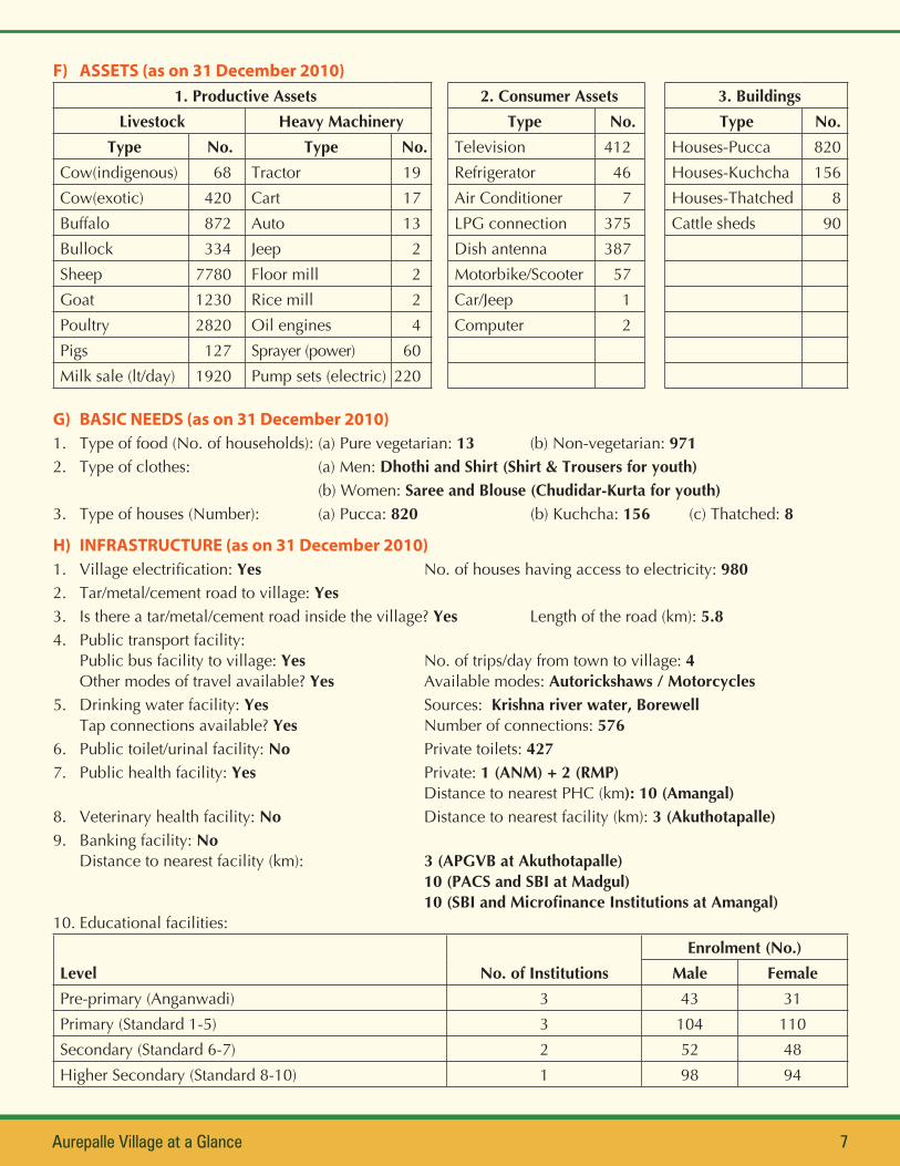
F) ASSETS (as on 31 December 2010)1. Productive Assets 2. Consumer Assets 3. Buildings
Livestock Heavy Machinery Type No. Type No.Type No. Type No. Television 412 Houses-Pucca 820
Cow(indigenous) 68 Tractor 19 Refrigerator 46 Houses-Kuchcha 156Cow(exotic) 420 Cart 17 Air Conditioner 7 Houses-Thatched 8Buffalo 872 Auto 13 LPG connection 375 Cattle sheds 90Bullock 334 Jeep 2 Dish antenna 387Sheep 7780 Floor mill 2 Motorbike/Scooter 57Goat 1230 Rice mill 2 Car/Jeep 1Poultry 2820 Oil engines 4 Computer 2Pigs 127 Sprayer (power) 60Milk sale (lt/day) 1920 Pump sets (electric) 220
G) BASIC NEEDS (as on 31 December 2010)1. Type of food (No. of households): (a) Pure vegetarian: 13 (b) Non-vegetarian: 9712. Type of clothes: (a) Men: Dhothi and Shirt (Shirt & Trousers for youth) (b) Women: Saree and Blouse (Chudidar-Kurta for youth)3. Type of houses (Number): (a) Pucca: 820 (b) Kuchcha: 156 (c) Thatched: 8
H) INFRASTRUCTURE (as on 31 December 2010)1. Village electrification: Yes No. of houses having access to electricity: 9802. Tar/metal/cement road to village: Yes3. Is there a tar/metal/cement road inside the village? Yes Length of the road (km): 5.84. Public transport facility:
Public bus facility to village: Yes No. of trips/day from town to village: 4Other modes of travel available? Yes Available modes: Autorickshaws / Motorcycles
5. Drinking water facility: Yes Sources: Krishna river water, BorewellTap connections available? Yes Number of connections: 576
6. Public toilet/urinal facility: No Private toilets: 4277. Public health facility: Yes Private: 1 (ANM) + 2 (RMP) Distance to nearest PHC (km): 10 (Amangal)8. Veterinary health facility: No Distance to nearest facility (km): 3 (Akuthotapalle)9. Banking facility: No
Distance to nearest facility (km): 3 (APGVB at Akuthotapalle) 10 (PACS and SBI at Madgul) 10(SBIandMicrofinanceInstitutionsatAmangal)10. Educational facilities:
Level No. of InstitutionsEnrolment (No.)
Male FemalePre-primary (Anganwadi) 3 43 31Primary (Standard 1-5) 3 104 110Secondary (Standard 6-7) 2 52 48Higher Secondary (Standard 8-10) 1 98 94
Citation: Ramana Reddy K, Mohan Rao Y, Kiresur VR and Bantilan MCS. 2011. Aurepalle Village at a Glance. Patancheru 502 324, Andhra Pradesh, India: International Crops Research Institute for the Semi-Arid Tropics.
The International Crops Research Institute for the Semi-Arid Tropics (ICRISAT) is a non-profit, non-political organization that conducts agricultural research for development in Asia and sub-Saharan Africa with a wide array of partners throughout the world. Covering 6.5 million square kilometers of land in 55 countries, the semi-arid tropics have over 2 billion people, and 644 million of these are the poorest of the poor. ICRISAT and its partners help empower these poor people to overcome poverty, hunger, malnutrition and a degraded environment through better and more resilient agriculture.
ICRISAT is headquartered in Hyderabad, Andhra Pradesh, India, with two regional hubs and four country offices in sub-Saharan Africa. It belongs to the Consortium of Centers supported by the Consultative Group on International Agricultural Research (CGIAR).
About ICRISAT
www.icrisat.org
ICRISAT-PatancheruPatancheru 502 324, Andhra Pradesh, India
Tel +91 40 30713071 Fax +91 40 [email protected]
11. Agricultural input shops:Input Available in village? If no, nearest available place Distance from village (km)
Seed No Amangal 10Fertilizer No Amangal 10Pesticide No Amangal 10Machinery – Purchase No Hyderabad 70Machinery – Custom hiring Yes
12. Agricultural output market:Weekly shandy in the village? No Place and day where available? Amangal, FridayNo. of wholesale traders/commission agents in/visiting the village: 14
13. Storage godowns/warehouses: No
14. Other business units (number):Grocery shop: 19 PDS Shop: 2 Hotel/Canteen: 2Flour Mill: 2 Chilli/spices grinding shop: 3 Meat shop: 6Liquor shop: 21 Carpenter-cum-blacksmith: 16 Goldsmith: 1Cobbler: 1 Cycle & motor cycle repair shop: 2 Mason: 7Money lenders: 19 Timber and wood cutting: 1 Cloth shop: 2
15. Other institutions (number):SHG/Sakhi Mandal: 51 NGO: 1 Milk Dairies: 6 (Coop-2, Pvt-4)Post Office: 1 Youth Club: 2 Bhajan Mandal: 2Chit Fund: 12 Toddy Tappers’ Association: 1 (110 members)
16. Place of worship (No): Temple: 6
I) GOVERNMENT WELFARE PROGRAMS / POLICIES (As on 31 December 2010)
Government ProgramBeneficiaries
(No. of households)Mahatma Gandhi National Rural Employment Guarantee Scheme (MGNREGS) 830Drought relief package for farmers 602Indiramma Gruha Nirmana Yojana 440Mid-day meal scheme for school going children 407Pension scheme (Old age, Widow and Handicapped) 439Public Distribution System (PDS) 998Anganwadi 94Free electric power for agriculture 500