I BUTT TOWNSHIP PROPERTY I - Ontario
15
I I I I I I I I I I I I I I I I I I I MAGNETOMETER SURVEY REPORT on the BUTT TOWNSHIP PROPERTY BUTT TOWNSHIP DISTRICT OF NIPISSING ONTARIO .OJ· 4 232 JAN 2 6 2 009 FOR DAN PATRIE EXPLORATION LTD. prepared by: L.D.S. Winter, P.Geo. 23 January 2009
Transcript of I BUTT TOWNSHIP PROPERTY I - Ontario

I I I I I I I I I I I I I I I I I I I
MAGNETOMETER SURVEY REPORT
on the
BUTT TOWNSHIP PROPERTY
BUTT TOWNSHIP
DISTRICT OF NIPISSING
ONTARIO
.OJ· 4 232 Q\7~hj)
JAN 2 6 2009
FOR GEOSCIENC~ ASi;J~~SMENT
DAN PATRIE EXPLORATION LTD.
prepared by:
L.D.S. Winter, P.Geo.
23 January 2009

I I I I I I I I I I I I I I I I I I I
TABLE OF CONTENTS
1. Introduction
2. Pmperty
2.1 Property Description 2.2 Location, Access and Infrastructure
3. RI3gionai Geology
4. Instrumentation and Work Done
5. Results
5.1 Magnetometer Survey
6. Summary and Conclusions
7. PE~rsonnel
8. Expend itu res
RE~ferences
CElrtificate of Qualification
LIST OF FIGURES
Figure 1: Location Map Figure 2: Claims Map Figure 3: Regional Geology Figure 4: Property Grid
LIST OF MAPS
Map 1: Grid Map - lines surveyed 1: 1 a 000 Map 2: Total Magnetic Intensity Survey - Contoured Readings 1: 1 a 000
PAGE
3
3
3 4
5
6
8
8
8
9
10
10
11
2

I I I I I I I I I I I I I I I I I I I
1. lNTRODUCTION
Dan Patrie Exploration Ltd. (OPEL or the Company) holds 10 claims containing
88 units and covering 1408 ha in Butt township, District of Nipissing, Ontario at 79°_
5.8'1/11 longitude, 45°-42.5'N latitude (Figure 1). The claims were acquired for their
potential to host uranium and rare earth mineralization of economic interest.
Between 12 January and 21 January 2009 the Company, carried out a
magnetometer survey on the Property. The following report describes the work
CarriE!d out on the subject claims and the results obtained.
2. PROPERTY
2.1 PROPERTY DESCRIPTION
The Butt Township Property is comprised of 10 unpatented contiguous mining
claims containing 10 units and covering 1408 ha as listed in Table 1 and as
illustrated in Figure 2. The Property is located within the Butt township claim map
(M-0064). The claims are held in the name of Dan Patrie Exploration Ltd.
3

I I I I I I I I I I I I I I I I FIGURE 1
DAN PATRIE EXPLORATION LTD.
I BUTT TOWNSHIP PROPERTY
I Location Map Scale 1:750000 January 2009
I

I I I I I I I I I I I I I I I I I I I
TABLE 1
DAN PATRIE EXPLORATION LTD.
BUTT TOWNSHIP PROPERTY
Township Claim Number Claim Due Date Units Area (ha)
Butt 3019181 2009-Jan-25 3 48
Butt 3019182 2009-Jan-25 3 48
Butt 4214914 2009-Jan-25 12 192
Butt 4214915 2009-Jan-25 12 192
Butt 4214916 2009-Jan-25 8 128
Butt 4214917 2009-Jan-25 12 192
Butt 4214918 2009-Jan-25 12 192
Butt 4214919 2009-Jan-25 2 32
Butt 4219905 2009-Apr-13 12 192
Butt 4219906 2009-Apr -1 ::~ 12 192
TOTAL 88 1408
2.2 LOCATION, ACCESS AND INFRASTRUCTURE
The Property is located approximately 50 km north-northeast of Huntsville,
Ontario at 79°-5.8'W longitude, 45°-42.5'N latitude and centred at UTM, NAD 83,
Zone 17 co-ordinates 650000mE; 5062500mN (Figure 2).
Access to the Property is by road from Provincial Highway #11 at Elmsdale,
Ontario about 20 km north of Huntsville. From Elmsdale, Provinc:ial Highway 518
leads east to Kearney (10 km) then proceed north from here an additional 10 km to
Sand Lake. From Sand Lake to the Property is about 12 km on the Forestry Tower
Road. A number of logging roads provide good access to a/l sections of the
Property.
4

I I I I I I I I I I I I I I I I I I I
&- ~ . 1 /
.... - (f,.. .... , ~,) ~.-
<01
...... ~ _.-f !
Scale 1:40 000
"...
V
After Claim Map G-0064, Butt Township 1,'
FIGURE 2
DAN PATRIE EXPLORATION LTD. BUTT TOWNSHIP PROPERTY
Claims Map January 2009

I I I I I I I I I I I I I I I I I I I
Algonquin Park is immediately east of the Property and the Cal Graphite
Property is immediately to the north (Figure 2).
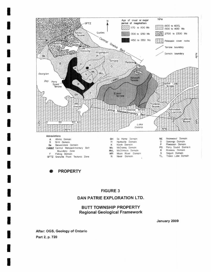
3. GEOLOGY
The Butt township property is located within the Kiosk domain of the Algonquin
Terrain of the Central Gneiss Belt of the Western Grenville Province, Ontario (Figure
3). The central Gneiss Belt and the Central Metasedimentary Belt are the 2 major
subdivisions of the Grenville Province in Ontario.
The Central Gneiss Belt consists mainly of upper amphibolite and local granulite
facies, quartzo-feldspathic gneisses chiefly of igneous origin with subordinate
paragneiss. The dominant structural trend is northeasterly, however, northwesterly
trends occur along Georgian Bay. The Central Gneiss Belt consists of a variety of
Archean to Mesoproterozoic crustal segments, all of which have been affected by
the "Grenville Orogeny". Rocks of 3 main ages are present. North of the French
River, reworked Archean and Paleoproterozoic gneisses of the I\lipissing Terrane
are intruded by Mesoproterozoic (1700 to 1350 Ma) plutonic rocks, with granitic and
monzonitic rocks predominant. The bulk of the Central Gneiss Belt (Algonquin and
Tomiko terranes) consists of Mesoproterozoic gneisses (1800 to 1600 Ma) intruded
by 1500 to 1400 million-year-old granitic and monzonitic plutons that may represent
an extension of the Eastern Granite-Rhyolite Province across thl3 Grenville Front.
The Parry Sound Terrane consists of mafic to intermediate rocks extracted from the
mantle at about 1450 to 1350 Ma.
Distinctive lithotectonic terranes, some further sub-divided into domains, have
been identified within the Central Gneiss Belt. The terranes and domains are
distinguished by differences in rock types, internal structure, me~tamorphic grade,
geologic history and locally by geophysical signature. They are bounded by zones
of intensely deformed layered rocks traceable for tens of kilometres.
5
I I I I I I I I I I I I I I I I I I I
Georgian
Boy
Abbreviations A Ahmic Domain B Britt Doma in
Be Beaverstone Domain CMBBZ Cenrrol Melosedimenlory BelT
Boundary Zone F Fishog Domain
GFTZ Grenville Front Tectonic Zone
• PROPERTY
Quebec f
Age of crust or mojor period of magmatism
~ 1170 10 1100 Ma
1300 10 1250 Me
.. 1450 10 1350 Ma
Lake Ontario
GH Go Home Domain H Huntsville Domain K Kiosk Domain
Me McCraney Domain MeL McClintock Domain MR Moon River Domoin N Navar Domain
FIGURE 3
DAN PATRIE EXPLORATION LTD.
BUTT TOWNSHIP PROPERTY Regional Geological Framework
After: OGS, Geology of Ontario
Part 2, p. 720
/':f '>-'118oo to 1600, '.!;~~~m 1500 to 1400 Ma
~ 2700 to 2300 Me
~ FI:lleoloic cover roclls
/ Terrene boundary
/ Domain boundary
NE Nepewassi Domain o Opeongo Domain P Powossan Domain
PS Parry Sound Domain R Rosseau Domain S Seguin Domain
TL Tilden Lake Domain
January 2009

I I I I I I I I I I I I I I I I I I I
The Algonquin Terrane consists of quartzo-feldspathic gneisses of plutonic and
supracrustal origin characterized by a complex pattern of structurall domains. Thus,
the Algonquin Terrane is an area of Mesoproterozoic, polycyclic rocks, consisting of
a number of domains (domains and subdomains). The southern and western parts
of the Algonquin Terrane have been subdivided into the Britt, Ahmic, Kiosk,
Rosseau, Go Home, Huntsville, Novar, McClintock doamins interpreted to represent
the lowest portion of a stacked succession of thrust sheets in this region. Large
folded sheets of gneissic granites with primary isotopic ages in the 1500 to 1400
million year range occur in all these domains. Rocks of this age are common in the
Eastern Granite-Rhyolite Province and the Algonquin Terrane and probably
represent a section of Mesoproterozoic crust (1800 to 1600 Ma) extensively injected
by granitic magmas of the Eastern Granite-Rhyolite Province. (CE!Iltral Gneiss Belt,
Grenville Province, Part 2, Section 19, Geology of Ontario, Easton, 1992).
The Butt township property which lies within the Kiosk domain, is underlain by
mafic, quartzo-feldspathic and metapelitic units at the amphibolite to granulite grade
of metamorphism. In turn these units host radioactive pegmatite dykes which host
allanite, uraninite, pyrochlore, columbite and other rare earth and uranium-bearing
minerals (Ferguson, 1971; Hewitt, 1967).
4. INSTRUMENTATION AND WORK DONE
Between 12 January and 21 January 2009 inclusive, a program of geophysical
surveying along GPS and compass lines at 100 m spacings was carried out over the
Butt Property grid. A total field magnetometer survey with readings being taken at
25 m intervals was carried out over 105 line-kilometres (Figure 4) 8l (Maps 1 and 2) .
The survey was done using two, 2 man crews. In each crew, one person
determined the line and the station locations using a Gompass and a GPS unit and
the second person carried out the magnetometer survey and recorded the readings.
The survey was carried out using 2 Scintrex Envi magnetometer units. The Envi
6

I I I I I I I I I I I I I I I I I I I
r 1 I J , .I
...
FIGURE 4
DAN PATRIE EXPLORATION LTD.
Scale: 1 em = 400 m
BUTT TOWNSHIP PROPERTY Property Grid
-..... -
January 2009

I I I I I I I I I I I I I I I I I I I
Mag has the capability to measure the total field combined with an Envi
Magnetometer as a base station for correcting magnetic diurnal drift. These are
total field magnetometers which measure the magnetic field through the use of
proton processional effects caused by the interaction of a magnetic field with a spin
aligned, proton rich fluid.
An instrument accuracy precision and resolution of 0.1 nt may be obtained with
these instruments under ideal conditions. While in gradient mode which was not
done at this time, the unit has the means of measuring both the total field and the
gradient of the total field with two sensors simultaneously. In gradient mode, the
instrument sharply defines the magnetic responses determined by the total field. It
individually delineates closely spaced anomalies rather than collectively identifying
them under one broad magnetic response. Also, when doing a gradient survey the
instrument enables one to conduct a gradient survey during a magnetic storm
because the technique of simultaneously measuring with the two sensors cancels
out the effects of diurnal magnetic variations.
Microprocessors contained in these instruments allow for the collection of the
readings along with the time and its position in digital form suitablE! for downloading
to a computer for date processing.
A total of 105 km of magnetic readings were taken along the linBs at 100 m apart
with 25 m station intervals. The field measurements were corrected for diurnal
variations of the earth's magnetic field by direct subtraction of the base station
readings from the reading taken at the same moment in the field units. The
corrected data was downloaded to a computer for plotting. The results are
presented in Map 2.
The geophysical survey was carried out by Dan Patrie Exploration Ltd., Massey,
Ontario an experienced geophysical contractor.
7

I I I I I I I I I I I I I I I I I I I
5. RESULTS
5.1 MAGNETOMETER SURVEY
The total field magnetic readings taken from the Butt Township Property (Map 2)
indicate that the property is divided into 2 magnetic domains along a line trending
approximately 3300 (N600 W). To the northeast of this line, the magnetic readings
are generally low and vary between approximately 55000 nT to 55500 nT with
scattered, more elevated values to a maximum of approximately 56000 nT. Two
trends appear to be present, 3300 and 0600 - 0700 with the 3300 trend being more
noticeable.
The southwestern part of the property has in general a higher magnetic
susceptibility with values generally in the 55600 nT to :56200 nT range. The higher
values show narrow, approximately east-west trending zones in the eastern part of
the domain whereas in the western part - lines 13+00E and 14+00E much broader
areas of high values between 7+00S and 18+00S are present. A second area of
higher values over a larger area is present between line 13+00E and line 21+00E
(part of this area not surveyed) centred at about 28+00S.
6. SUMMARY AND CONCLUSIONS
A total field magnetic survey was carried out on the Butt Township Property with
readings being taken every 25 m on 105 km of lines with lines spaced at 100 m.
The survey shows that the Property is underlain by rock units that appear to form
two magnetic domains, one to the northeast and one to the southwest. The domain
to the northeast has lower magnetic values generally below 55t500 nT while the
domain to southwest shows magnetic values generally above 555010 nT to maximum
values of about 56200 nT. The boundary between these 2 domains trends 3300 and
divides the Property approximately in half.
8

I I I I I I I I I I I I I I I I I I I
The Property was acquired for its potential for uranium and rare earth
mineralization hosted in pegmatite dykes as reported by earlier workers (Ferguson
1971, Hewitt 1967). It is recommended that the Property be geologically mapped,
prospected and sampled to determine:
1. The location of the radioactive pegmatites, their trends and their relation to the
lithologic units and,
2. The distribution of the various lithological units and their rEllationship to the
magnetic patterns.
7. PERSONNEL
The magnetometer survey was carried out by Dan Patrie Exploration Ltd.,
Massey, Ontario using the following personnel..
Mike Faulkner, Walford, Ontario
Stephen Faulkner, Walford, Ontario
Gab Roy, Elliot Lake, Ontario
Mike Whalen, Walford, Ontario.
9

I I I I I I I I I I I I I I I I I I I
1.
2.
3.
4.
5.
1.
2.
3.
4.
8. EXPENDITURES
Expenditures on the Property for the magnetometer survey are as follows.
105 km @ $200/km for the survey: 2 man crews;
1 man compass, GPS & picketing; 1 man reading mag
Three snowmobiles for 10 days @ $1 OO/machine/day
Mob/demob; Massey to Property
Compiling field data and plotting maps
Report and interpretation
Sub-Total
GST@5%
Total Expenditure
$ 21,000.00
3,000.00
1,000.00
1,200.00
1,850.00
$ 28,050.00
1,402.50
$ 29,452.50
L.D.S. Wint,er, P.Geo.
23 January 2009
REFERENCES
Easton, R.M., 1992 The Grenville Province and the Proterozoic History of Southern and Central Ontario; p. 715-754, The Central Gneiss 8elt, in Geology of Ontario, Part 2, MNDM.
Ferguson, S.A, 1971 Columbium (Niobium) Deposits of Ontario, ODM, Mineral Resources Circular 14, p. 49.
Hewitt, D.F., 1967 Uranium and Thorium Deposits of Southern Ontario, ODM, Mineral Resources Circular No.4, p. 47.
Marmot, C. and Johnston, M., 1987 Mineral Deposits Studies in the Huntsville-Parry Sound-Powassan Area -A Progress Report, OFR 5647, OGS, Mines & Minerals Division.
10

I I I I I I I I I I I I I I I I I I I
L.D.S. Winter
1849 Oriole Drive, Sudbury, ON P3E 2W5 (705) 560-6967
(705) 560-6997 (fax) email: [email protected]
CERTIFICATE OF AUTHOR
I, Lionel Donald Stewart Winter, P. Geo. do hereby certify that:
1. I am currently an independent consulting geologist.
2. I graduated with a degree in Mining Engineering (B.A.Sc.) from the University of Toronto in 1957. In addition, I have obtained a Master of Science (Applied) (M.Sc. App.) from McGill University, Montreal, ac.
3. I am a Life Member of the Canadian Institute of Mining, a Life Member of the Prospectors and Developers Association of Canada, a Registered Geoscientist in Ontario and in British Columbia (P.Geo.).
4. I have worked as a geologist for a total of 50 years since my graduation from university.
5. I have read the definition of "qualified person" set out in National Instrument 43-101 ("NI43-101") and certify that by reason of my education, affiliation with a professional association (as defined in NI 43-101) and past relevant work experience, I fulfill the requirements to be a "qualified person" for the purposes of NI43-101.
6. I am the author responsible for the preparation of the Geophysilcal Survey Report titled "Magnetometer Survey Report on the Butt Township Pmperty, District of Nipissing, Ontario" and dated January 23, 2009 (the "Technical Report").
Dated this 23 rd Day of January, 2009
L.D.S. Winter. P.Geo.
11