HYPERPYCNAL RIVERS AND PRODELTAIC SHELVES IN THE ... · Leithold 1993, 1994; Sethi and Leithold...
26
Journal of Sedimentary Research, 2009, v. 79, 184–209 Research Article DOI: 10.2110/jsr.2009.026 HYPERPYCNAL RIVERS AND PRODELTAIC SHELVES IN THE CRETACEOUS SEAWAY OF NORTH AMERICA JANOK P. BHATTACHARYA 1 AND JAMES A. MACEACHERN 2 1 Robert E. Sheriff Professor of Sequence Stratigraphy, Geosciences Department, University of Houston, 4800 Calhoun Road, Houston, Texas 77204-5007, U.S.A. 2 Department of Earth Sciences, Simon Fraser University, Burnaby, British Columbia, V5A 1S6, Canada e-mail: [email protected] ABSTRACT: Despite the historical assumption that the bulk of marine ‘‘shelf’’ mud is deposited by gradual fallout from suspension in quiet water, recent studies of modern muddy shelves and their associated rivers show that they are dominated by hyperpycnal fluid mud. This has not been widely applied to the interpretation of ancient sedimentary fluvio-deltaic systems, such as dominate the mud-rich Cretaceous Western Interior Seaway of North America. We analyze two such systems, the Turonian Ferron Sandstone Member of the Mancos Shale Formation, in Utah, and the Cenomanian Dunvegan Formation in Alberta. Paleodischarge estimates of trunk rivers show that they fall within the predicted limits of rivers that are capable of generating hyperpycnal plumes. The associated prodeltaic mudstones match modern hyperpycnite facies models, and suggest a correspondingly hyperpycnal character. Physical sedimentary structures include diffusely stratified beds that show both normal and inverse grading, indicating sustained flows that waxed and waned. They also display low intensities of bioturbation, which reflect the high physical and chemical stresses of hyperpycnal environments. Distinct ‘‘mantle and swirl’’ biogenic structures indicate soupground conditions, typical of the fluid muds that represent the earliest stages of deposition in a hyperpycnal plume. Hyperpycnal conditions are ameliorated by the fact that these rivers were relatively small, dirty systems that drained an active orogenic belt during humid temperate (Dunvegan Formation) to subtropical (Ferron Sandstone Member) ‘‘greenhouse’’ conditions. During sustained periods of flooding, such as during monsoons, the initial river flood may lower salinities within the inshore area, effectively ‘‘prepping’’ the area and allowing subsequent floods to become hyperpycnal much more easily. Although shelf slopes were too low to allow long-run-out hyperpycnal flows, the storm-dominated nature of the seaway likely allowed fluid mud to be transported for significant distances across and along the paleo-shelf. Rapidly deposited prodeltaic hyperpycnites are thus considered to form a significant component of the muddy shelf successions that comprise the thick shale formations of the Cretaceous Western Interior Seaway. INTRODUCTION General facies models for the interpretation of ancient marine mudstones historically assume that most shelf mud is deposited in quiet water by simple suspension settling (Pettijohn 1975; Bhattacharya and Walker 1992; Nichols 1999; Prothero and Schwab 2004; Boggs 2006). In a landmark paper Rine and Ginsburg (1985) presented one of the first major studies of a high-energy prograding muddy shoreline and inner shelf deposit along the modern Suriname coast. Other major delta complexes, such as the Mekong in Vietnam (Ta et al. 2005), the Atchafalaya in the Gulf of Mexico (Augustinus 1989; Allison and Neil 2003; Rotondo and Bentley 2003), the Po in the Adriatic (Cattaneo et al. 2003 and Cattaneo et al. 2007), the Fly in Papua New Guinea (Walsh et al. 2004), among others (Allison and Nittrouer 1998), show major mud-dominated coastlines and inner-shelf mud belts, typically elongated downdrift of the river mouth. Other oceanographic studies emphasize the importance of rapidly deposited fluid muds in shelf construction (McCave 1972; Nittrouer et al. 1986; Kineke et al. 1996; Kuehl et al. 1996; Kuehl et al. 1997; Kineke et al. 2000; Hill et al. 2007; Liu et al. 2002; Bentley 2003). Many modern shelf muds are now recognized to have accumulated as prodeltaic deposits. These may be deposited directly from hyperpycnal mud plumes related to times of elevated river discharge during floods (Fig. 1). Rapid flocculation of clays and sediment settling may also occur within an initially low-sediment-concentration hypopycnal plume, caus- ing it to evolve into a hyperpycnal flow (Parsons et al. 2001) (Fig. 1). This can happen quickly, within hours or days of the initial river flood. Storms, fair-weather waves, and tides may also resuspend mud at the sea floor, which subsequently migrates along the shelf as a dilute, hyperpycnal geostrophic fluid-mud belt (Nemec 1995; Kineke et al. 2000; Mulder and Alexander 2001; Bentley 2003; Rotondo and Bentley 2003; Draut et al. 2005). These mudstones typically show distinctly laminated to bedded fabrics with a corresponding lack of bioturbation, reflecting much more rapid sedimentation rates than recorded during pelagic settling of clay from suspension (e.g., MacEachern et al. 2005; MacEachern et al. 2007a). Sediment accumulation rates of up to 20 cm per year have been recorded in the modern Atchafalaya mud belt, compared to less than 1 cm/year in the more distal offshore (Allison and Neill 2003). Despite these advances in our understanding of mud transport and deposition in modern shelves, most studies of ancient hyperpycnal deposits or of similar ‘‘sustained’’ flow turbidites focus on sandstones Copyright E 2009, SEPM (Society for Sedimentary Geology) 1527-1404/09/079-184/$03.00
Transcript of HYPERPYCNAL RIVERS AND PRODELTAIC SHELVES IN THE ... · Leithold 1993, 1994; Sethi and Leithold...
Journal of Sedimentary Research, 2009, v. 79, 184–209
Research Article
DOI: 10.2110/jsr.2009.026
HYPERPYCNAL RIVERS AND PRODELTAIC SHELVES IN THE CRETACEOUS SEAWAY OFNORTH AMERICA
JANOK P. BHATTACHARYA1AND JAMES A. MACEACHERN2
1Robert E. Sheriff Professor of Sequence Stratigraphy, Geosciences Department, University of Houston, 4800 Calhoun Road, Houston, Texas 77204-5007, U.S.A.2Department of Earth Sciences, Simon Fraser University, Burnaby, British Columbia, V5A 1S6, Canada
e-mail: [email protected]
ABSTRACT: Despite the historical assumption that the bulk of marine ‘‘shelf’’ mud is deposited by gradual fallout fromsuspension in quiet water, recent studies of modern muddy shelves and their associated rivers show that they are dominated byhyperpycnal fluid mud. This has not been widely applied to the interpretation of ancient sedimentary fluvio-deltaic systems,such as dominate the mud-rich Cretaceous Western Interior Seaway of North America. We analyze two such systems, theTuronian Ferron Sandstone Member of the Mancos Shale Formation, in Utah, and the Cenomanian Dunvegan Formation inAlberta. Paleodischarge estimates of trunk rivers show that they fall within the predicted limits of rivers that are capable ofgenerating hyperpycnal plumes.The associated prodeltaic mudstones match modern hyperpycnite facies models, and suggest a correspondingly hyperpycnal
character. Physical sedimentary structures include diffusely stratified beds that show both normal and inverse grading,indicating sustained flows that waxed and waned. They also display low intensities of bioturbation, which reflect the highphysical and chemical stresses of hyperpycnal environments. Distinct ‘‘mantle and swirl’’ biogenic structures indicatesoupground conditions, typical of the fluid muds that represent the earliest stages of deposition in a hyperpycnal plume.Hyperpycnal conditions are ameliorated by the fact that these rivers were relatively small, dirty systems that drained an activeorogenic belt during humid temperate (Dunvegan Formation) to subtropical (Ferron Sandstone Member) ‘‘greenhouse’’conditions. During sustained periods of flooding, such as during monsoons, the initial river flood may lower salinities within theinshore area, effectively ‘‘prepping’’ the area and allowing subsequent floods to become hyperpycnal much more easily.Although shelf slopes were too low to allow long-run-out hyperpycnal flows, the storm-dominated nature of the seaway likelyallowed fluid mud to be transported for significant distances across and along the paleo-shelf. Rapidly deposited prodeltaichyperpycnites are thus considered to form a significant component of the muddy shelf successions that comprise the thick shaleformations of the Cretaceous Western Interior Seaway.
INTRODUCTION
General facies models for the interpretation of ancient marine mudstoneshistorically assume that most shelf mud is deposited in quiet water bysimple suspension settling (Pettijohn 1975; Bhattacharya andWalker 1992;Nichols 1999; Prothero and Schwab 2004; Boggs 2006). In a landmarkpaper Rine and Ginsburg (1985) presented one of the first major studies ofa high-energy prograding muddy shoreline and inner shelf deposit alongthe modern Suriname coast. Other major delta complexes, such as theMekong in Vietnam (Ta et al. 2005), the Atchafalaya in the Gulf of Mexico(Augustinus 1989; Allison and Neil 2003; Rotondo and Bentley 2003), thePo in the Adriatic (Cattaneo et al. 2003 and Cattaneo et al. 2007), the Fly inPapua New Guinea (Walsh et al. 2004), among others (Allison andNittrouer 1998), show major mud-dominated coastlines and inner-shelfmud belts, typically elongated downdrift of the river mouth. Otheroceanographic studies emphasize the importance of rapidly deposited fluidmuds in shelf construction (McCave 1972; Nittrouer et al. 1986; Kineke etal. 1996; Kuehl et al. 1996; Kuehl et al. 1997; Kineke et al. 2000; Hill et al.2007; Liu et al. 2002; Bentley 2003).Many modern shelf muds are now recognized to have accumulated as
prodeltaic deposits. These may be deposited directly from hyperpycnal
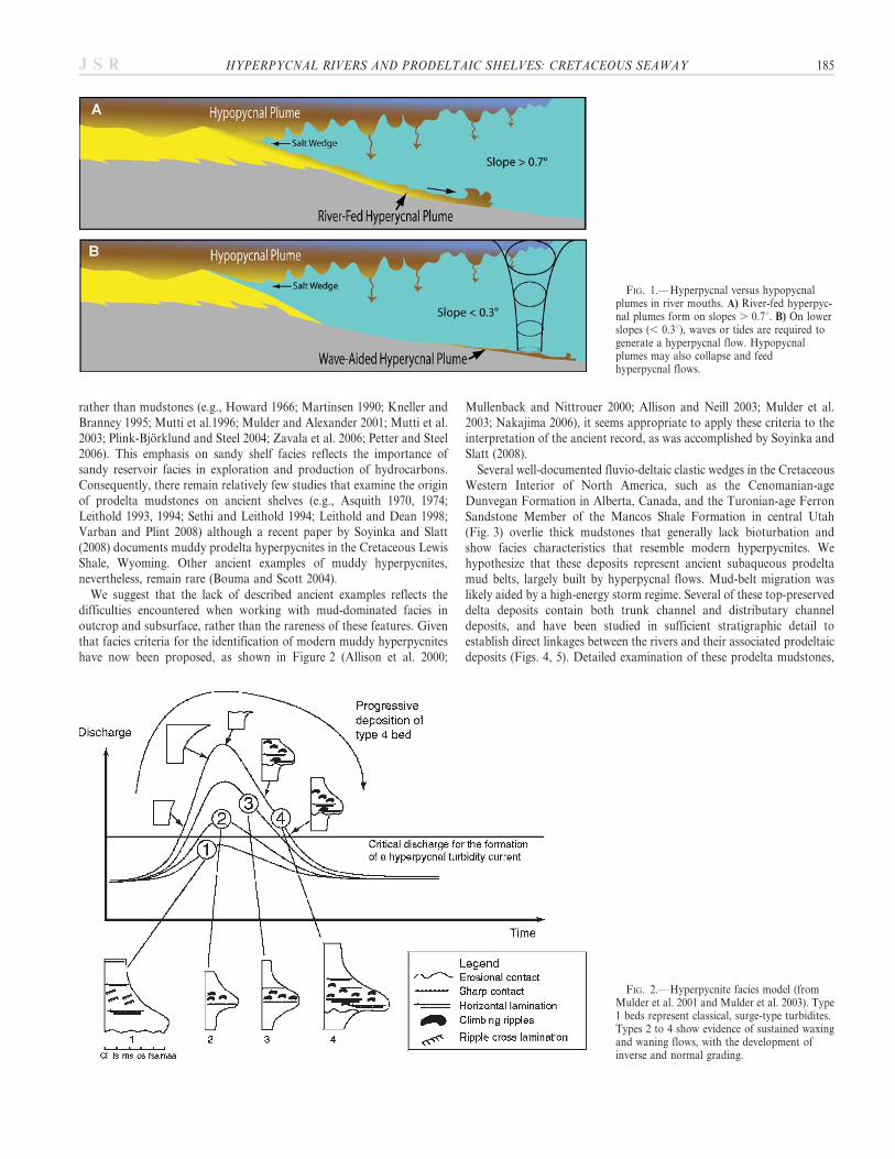
mud plumes related to times of elevated river discharge during floods(Fig. 1). Rapid flocculation of clays and sediment settling may also occurwithin an initially low-sediment-concentration hypopycnal plume, caus-ing it to evolve into a hyperpycnal flow (Parsons et al. 2001) (Fig. 1). Thiscan happen quickly, within hours or days of the initial river flood.Storms, fair-weather waves, and tides may also resuspend mud at the seafloor, which subsequently migrates along the shelf as a dilute,hyperpycnal geostrophic fluid-mud belt (Nemec 1995; Kineke et al.2000; Mulder and Alexander 2001; Bentley 2003; Rotondo and Bentley2003; Draut et al. 2005). These mudstones typically show distinctlylaminated to bedded fabrics with a corresponding lack of bioturbation,reflecting much more rapid sedimentation rates than recorded duringpelagic settling of clay from suspension (e.g., MacEachern et al. 2005;MacEachern et al. 2007a). Sediment accumulation rates of up to 20 cmper year have been recorded in the modern Atchafalaya mud belt,compared to less than 1 cm/year in the more distal offshore (Allison andNeill 2003).
Despite these advances in our understanding of mud transport anddeposition in modern shelves, most studies of ancient hyperpycnaldeposits or of similar ‘‘sustained’’ flow turbidites focus on sandstones
Copyright E 2009, SEPM (Society for Sedimentary Geology) 1527-1404/09/079-184/$03.00
rather than mudstones (e.g., Howard 1966; Martinsen 1990; Kneller andBranney 1995; Mutti et al.1996; Mulder and Alexander 2001; Mutti et al.2003; Plink-Bjorklund and Steel 2004; Zavala et al. 2006; Petter and Steel2006). This emphasis on sandy shelf facies reflects the importance ofsandy reservoir facies in exploration and production of hydrocarbons.Consequently, there remain relatively few studies that examine the originof prodelta mudstones on ancient shelves (e.g., Asquith 1970, 1974;Leithold 1993, 1994; Sethi and Leithold 1994; Leithold and Dean 1998;Varban and Plint 2008) although a recent paper by Soyinka and Slatt(2008) documents muddy prodelta hyperpycnites in the Cretaceous LewisShale, Wyoming. Other ancient examples of muddy hyperpycnites,nevertheless, remain rare (Bouma and Scott 2004).
We suggest that the lack of described ancient examples reflects thedifficulties encountered when working with mud-dominated facies inoutcrop and subsurface, rather than the rareness of these features. Giventhat facies criteria for the identification of modern muddy hyperpycniteshave now been proposed, as shown in Figure 2 (Allison et al. 2000;
Mullenback and Nittrouer 2000; Allison and Neill 2003; Mulder et al.2003; Nakajima 2006), it seems appropriate to apply these criteria to theinterpretation of the ancient record, as was accomplished by Soyinka andSlatt (2008).
Several well-documented fluvio-deltaic clastic wedges in the CretaceousWestern Interior of North America, such as the Cenomanian-ageDunvegan Formation in Alberta, Canada, and the Turonian-age FerronSandstone Member of the Mancos Shale Formation in central Utah(Fig. 3) overlie thick mudstones that generally lack bioturbation andshow facies characteristics that resemble modern hyperpycnites. Wehypothesize that these deposits represent ancient subaqueous prodeltamud belts, largely built by hyperpycnal flows. Mud-belt migration waslikely aided by a high-energy storm regime. Several of these top-preserveddelta deposits contain both trunk channel and distributary channeldeposits, and have been studied in sufficient stratigraphic detail toestablish direct linkages between the rivers and their associated prodeltaicdeposits (Figs. 4, 5). Detailed examination of these prodelta mudstones,
FIG. 1.—Hyperpycnal versus hypopycnalplumes in river mouths. A) River-fed hyperpyc-nal plumes form on slopes . 0.7u. B) On lowerslopes (, 0.3u), waves or tides are required togenerate a hyperpycnal flow. Hypopycnalplumes may also collapse and feedhyperpycnal flows.
FIG. 2.—Hyperpycnite facies model (fromMulder et al. 2001 and Mulder et al. 2003). Type1 beds represent classical, surge-type turbidites.Types 2 to 4 show evidence of sustained waxingand waning flows, with the development ofinverse and normal grading.
HYPERPYCNAL RIVERS AND PRODELTAIC SHELVES: CRETACEOUS SEAWAY 185J S R
especially in cores where details of mud facies are far more easilyobserved, allow comparison with recently published hyperpycnite faciesmodels and examples.
Purpose of This Paper
The purpose of this paper is two-fold. The first goal is to estimatepaleo-discharge volumes of these ancient rivers in conjunction with otherpaleogeographic and paleoclimatic constraints, in order to evaluate howcommonly the rivers that drained the Cretaceous Western InteriorSeaway were able to generate hyperpycnal plumes. The second goal is tosummarize the facies characteristics (sedimentological and ichnological)of prodelta and ‘‘shelf’’ mudstones preserved within deltaic clastic wedgesof the Cretaceous Western Interior Seaway, and to assess whatproportion of these wedges are likely to record the deposits ofhyperpycnal plumes. Lastly we compare these hyperpycnite deposits withother mudstones in the Cretaceous Seaway such as anoxic laminites.Aside from their general importance in constructing muddy shelves,
muddy hyperpycnites also may be important in the economic assessment ofpetroleum systems. Hyperpycnites may have lower source-rock potential(at least for oil) and may be significant in the generation of overpressuredconditions and the development of mobile shales, which form importanttraps in major deltaic complexes like the Niger and Mississippi, as well asbasins prone to shale tectonics, such as the Black Sea and Caspian Sea.
CRITERIA FOR GENERATION AND IDENTIFICATION OF HYPERPYCNAL FLOWS
Historically, hyperpycnal flows were thought to be common inlacustrine settings but relatively uncommon in marine settings due to
the salinity of seawater. It is now recognized that many marine deltas canexperience hyperpycnal conditions when sediment concentration is high,especially during exceptional river floods (Mulder and Syvitski 1995;Mulder and Alexander 2001; Plink-Bjorklund and Steel 2004). Mulderand Syvitski (1995) showed that hyperpycnal flows most commonly occurin sediment-rich, ‘‘dirty’’ rivers, with relatively small drainage basins, andparticularly adjacent to high-relief, tectonically active mountains inhumid climates, such as we believe characterized the Cretaceous forelandsuccession of North America. They also show that rivers with averagedischarge less than 6000 m3/s routinely generate hyperpycnal flows duringlarge seasonal floods, whereas larger continental-scale rivers, such as theMississippi or Ganges –Brahmaputra (104–105 m3/s) rarely, if ever,become hyperpycnal (Fig. 6).
The ability of a river to generate a hyperpycnal flow can be greatlyenhanced if the marine basin is already brackish, such as where estuarinemixing occurs (Felix et al. 2006). In some cases, marine shelves mayexperience salinity reduction during initial flooding events, which thenpredisposes the river mouth to generate hyperpycnal flows duringsubsequent river floods (Warne et al. 2002; Draut et al. 2005; Felix etal. 2006). Such conditions may be met during periods of freshet. Manyrivers experience dramatic changes in discharge as a function of seasonalclimate changes, as a result of major floods associated with storms, orwith snowmelt freshets (e.g., Thomson 1977). As a consequence, manyrivers can alternate from hypopycnal to hyperpycnal conditions, even infully marine settings (Nemec 1995; Mulder and Syvitski 1995; Parsons etal. 2001).
Many rivers produce both hyperpycnal and hypopycnal plumesconcurrently (Fig. 1A, Nemec 1995; Kineke et al. 2000). Low-concentra-
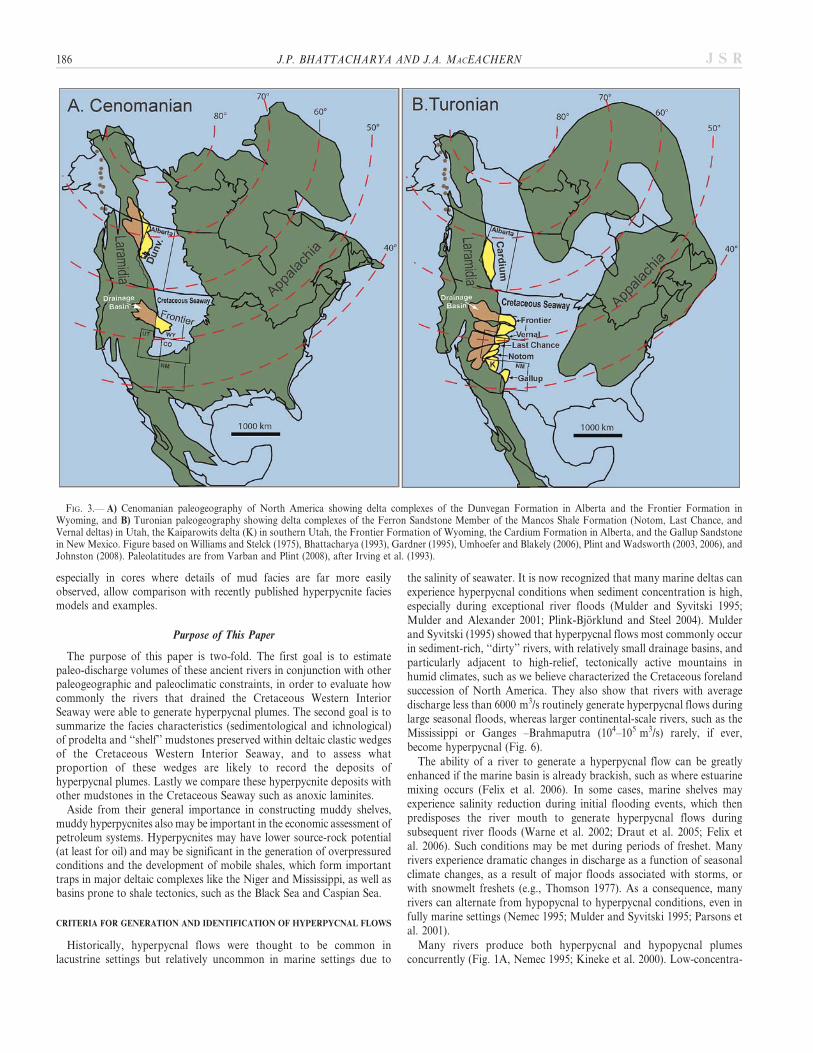
FIG. 3.— A) Cenomanian paleogeography of North America showing delta complexes of the Dunvegan Formation in Alberta and the Frontier Formation inWyoming, and B) Turonian paleogeography showing delta complexes of the Ferron Sandstone Member of the Mancos Shale Formation (Notom, Last Chance, andVernal deltas) in Utah, the Kaiparowits delta (K) in southern Utah, the Frontier Formation of Wyoming, the Cardium Formation in Alberta, and the Gallup Sandstonein New Mexico. Figure based on Williams and Stelck (1975), Bhattacharya (1993), Gardner (1995), Umhoefer and Blakely (2006), Plint and Wadsworth (2003, 2006), andJohnston (2008). Paleolatitudes are from Varban and Plint (2008), after Irving et al. (1993).
186 J.P. BHATTACHARYA AND J.A. MACEACHERN J S R

tion hypopycnal plumes may experience internal settling of sediment,which in turn may evolve into smaller hyperpycnal plumes that descendfrom the hypopycnal plume onto the seafloor (Parsons et al. 2001; Kinekeet al. 2000). Sediment may also partly settle and then become remobilizedby waves or tides as sediment-hugging fluid-mud flows, which have alsobeen termed hyperpycnal flows (Fig. 1B). The generation of hyperpycnalturbidity currents, directly fed by rivers, requires slopes greater than 0.7u(Bentley 2003; Friedrichs and Scully 2007) and may be a commonphenomena in steep-gradient deltas. In low-gradient deltas with slopes ,0.3u, hyperpycnal flows can be generated where wave or tidal processesadd to the turbulence at the seafloor (Fig. 1B), inhibiting near-bed mudfrom settling and allowing the sediment to migrate across and down-slopeas a fluid mud (e.g., Varban and Plint 2008; Friedrichs and Scully 2007;Bentley 2003).
Criteria for Identification of Hyperpycnites
Mulder et al. (2003) have suggested criteria for recognizing the depositsof river-flood-generated turbidity currents, which they term hyperpycnitesand which includes both sandy and muddy components (Fig. 2). A keycriterion is the formation of both inverse and normally graded beds,which reflects the sustained nature of the flow (e.g., Kneller and Branney1995). Their model suggests that there is a predominance of beds withgradational versus sharp boundaries. Within-bed scour is enhanced inhigher discharge events. They suggest that progressive erosion ornondeposition of the inversely graded beds occurs with time and distancefrom the shoreline. They also suggest that burrowing is typically low andthat flora and fauna are primarily allochthonous. The distinction of
hyperpycnal deposits formed by intermittent storm suspension versusdirectly river fed has not been fully elucidated, but we suggest that low-gradient, storm-induced hyperpycnites would likely show a greaterpreponderance of wave-formed sedimentary structures, such as hum-mocky cross stratification or oscillatory ripples.
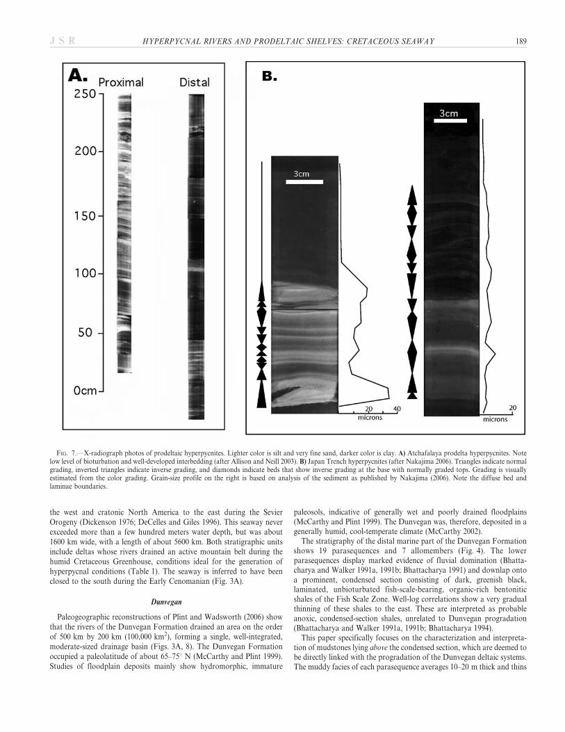
Some of the best-studied modern muddy hyperpycnites are thosegenerated by the Atchafalaya prodelta mud plume (Allison et al. 2000;Allison and Neill 2003; Neill and Allison 2005) and deep-sea hyperpyc-nites in the Japan Trench (Nakajima 2006). The Atchafalaya mud belt lieswithin the inner shelf in water depths of about 5 m. The mud belt reachesa maximum thickness of about 2.5 m. Mud dispersal across and along theshelf is aided by wave-generated currents, commonly associated withstorms and cold fronts, and a significant proportion of mud migratesonshore and builds the down-drift Louisiana chenier plain (Allison andNeill 2003). Cores from proximal and distal positions in the mud beltshow well-developed millimeter- to centimeter-thick sand or silt to claycouplets and are virtually devoid of burrowing (Fig. 7A). Normallygraded beds are ubiquitous. Silt and sand layers are sharp based and showlocalized scour surfaces. Undulating laminations in the sandy layers likelyrepresent wave reworking.
Muddy hyperpycnites deposited in the Central Japan Sea weredeposited 700 km from feeder-river mouths, on the Toyama Fan, atabout 3000 m water depth, well below the ability of storm waves toremobilize the sediment (Nakajima 2006). These hyperpycnites comprisesharp-based, centimeter- to decimeter-thick beds that show either normalor inverse grading (Fig. 7B). Beds also show alternating massive to flat-to-undulating lamination, the latter likely reflecting migration of low-amplitude current ripples. Rhythmically stratified beds are interpreted to
FIG. 4.—Regional cross section across the Alberta Foreland Basin, illustrating the allostratigraphic interpretation of the Upper Cretaceous Dunvegan Formation(from Bhattacharya 1993). The Dunvegan comprises several stacked allomembers (A to G). Each allomember is bounded by a regional transgressive flooding surface.Each allomember internally consists of several smaller-scale, offlapping, shingled parasequences that map as sandy delta lobes and their associated prodelta mudstones.Many delta lobes can be correlated into their updip feeder valleys, such as in Parasequence E1 (Fig. 8).
HYPERPYCNAL RIVERS AND PRODELTAIC SHELVES: CRETACEOUS SEAWAY 187J S R

be indicative of long-lived waxing and waning flows. Internal strata showrather diffuse boundaries. Bioturbation is minimal, although the greaterwater depths of these hyperpycnites compared to the shallow-waterexamples described above would likely preclude the deep-tier burrowingthat is more prevalent in shelf and shallower environments (e.g.,Pemberton and MacEachern 1997; MacEachern et al. 2005).
THE DUNVEGAN AND FERRON DELTAS
The synorogenic fluvio-deltaic clastic wedges of both the TuronianFerron Member and the Cenomanian Dunvegan Formation weredeposited into the Cretaceous Western Interior Seaway (Fig. 3), withina foreland basin that developed between the Cordilleran volcanic arc in
FIG. 5.—A) Utah base map showing paleogeography of the Ferron Last Chance Delta and location of regional cross section X–X9. B) Close-up of main study areashowing location of Ivie Creek Core # 3 (IC-3), Muddy Creek Core # 5 (MC-5), and other locations mentioned in the text. C) Stratigraphy of the basal progradationalpart of the Ferron Sandstone Member. Parasequence sets are numbered and individual parasequences are lettered. Note that Ferron parasequences are numbered fromoldest to youngest, opposite of the Dunvegan, wherein the units are numbered from youngest to oldest (see Fig. 4). Modified from Garrison and van den Bergh (2004).
FIG. 6.—Sediment concentration versus aver-age water discharge. Light gray area encom-passes range of data for 150 world rivers (afterMulder and Syvitski 1995). Dark gray box showssediment discharge required for generation ofhyperpycnal plumes. Range of discharge forFerron and Dunvegan rivers suggests that theyfrequently produced hyperpycnal plumes. Notethat hyperpycnal conditions are favored bysmaller rivers.
188 J.P. BHATTACHARYA AND J.A. MACEACHERN J S R
the west and cratonic North America to the east during the SevierOrogeny (Dickenson 1976; DeCelles and Giles 1996). This seaway neverexceeded more than a few hundred meters water depth, but was about1600 km wide, with a length of about 5600 km. Both stratigraphic unitsinclude deltas whose rivers drained an active mountain belt during thehumid Cretaceous Greenhouse, conditions ideal for the generation ofhyperpycnal conditions (Table 1). The seaway is inferred to have beenclosed to the south during the Early Cenomanian (Fig. 3A).
Dunvegan
Paleogeographic reconstructions of Plint and Wadsworth (2006) showthat the rivers of the Dunvegan Formation drained an area on the orderof 500 km by 200 km (100,000 km2), forming a single, well-integrated,moderate-sized drainage basin (Figs. 3A, 8). The Dunvegan Formationoccupied a paleolatitude of about 65–75u N (McCarthy and Plint 1999).Studies of floodplain deposits mainly show hydromorphic, immature
paleosols, indicative of generally wet and poorly drained floodplains(McCarthy and Plint 1999). The Dunvegan was, therefore, deposited in agenerally humid, cool-temperate climate (McCarthy 2002).The stratigraphy of the distal marine part of the Dunvegan Formation
shows 19 parasequences and 7 allomembers (Fig. 4). The lowerparasequences display marked evidence of fluvial domination (Bhatta-charya and Walker 1991a, 1991b; Bhattacharya 1991) and downlap ontoa prominent, condensed section consisting of dark, greenish black,laminated, unbioturbated fish-scale-bearing, organic-rich bentoniticshales of the Fish Scale Zone. Well-log correlations show a very gradualthinning of these shales to the east. These are interpreted as probableanoxic, condensed-section shales, unrelated to Dunvegan progradation(Bhattacharya and Walker 1991a, 1991b; Bhattacharya 1994).This paper specifically focuses on the characterization and interpreta-
tion of mudstones lying above the condensed section, which are deemed tobe directly linked with the progradation of the Dunvegan deltaic systems.The muddy facies of each parasequence averages 10–20 m thick and thins
FIG. 7.—X-radiograph photos of prodeltaic hyperpycnites. Lighter color is silt and very fine sand, darker color is clay. A) Atchafalaya prodelta hyperpycnites. Notelow level of bioturbation and well-developed interbedding (after Allison and Neill 2003). B) Japan Trench hyperpycnites (after Nakajima 2006). Triangles indicate normalgrading, inverted triangles indicate inverse grading, and diamonds indicate beds that show inverse grading at the base with normally graded tops. Grading is visuallyestimated from the color grading. Grain-size profile on the right is based on analysis of the sediment as published by Nakajima (2006). Note the diffuse bed andlaminae boundaries.
HYPERPYCNAL RIVERS AND PRODELTAIC SHELVES: CRETACEOUS SEAWAY 189J S R
basinward to 0 m over a distance of 30 to 70 km (Fig. 4), suggesting shelfslopes on the order of 0.01u to about 0.03u. Deposition of most mudoccurred within a few tens of meters of the shoreline, and shelf slopeswere likely too low to allow development of turbidity currents that werefar-traveling.The parasequences are abundantly cored, allowing detailed description
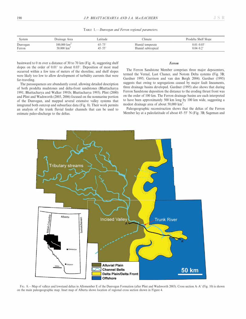
of both prodelta mudstones and delta-front sandstones (Bhattacharya1991; Bhattacharya and Walker 1991b; Bhattacharya 1993). Plint (2000)and Plint and Wadsworth (2003, 2006) focused on the nonmarine portionof the Dunvegan, and mapped several extensive valley systems thatintegrated both outcrop and subsurface data (Fig. 8). Their work permitsan analysis of the trunk fluvial feeder channels that can be used toestimate paleo-discharge to the deltas.
Ferron
The Ferron Sandstone Member comprises three major depocenters,termed the Vernal, Last Chance, and Notom Delta systems (Fig. 3B;Gardner 1995; Garrison and van den Bergh 2004). Gardner (1995)suggests that owing to segregations caused by major fault lineaments,three drainage basins developed. Gardner (1995) also shows that duringFerron Sandstone deposition the distance to the eroding thrust front wason the order of 100 km. The Ferron drainage basins are each interpretedto have been approximately 500 km long by 100 km wide, suggesting amodest drainage area of about 50,000 km2.
Paleogeographic reconstruction shows that the deltas of the FerronMember lay at a paleolatitude of about 45–55u N (Fig. 3B; Sageman and
TABLE 1.—Dunvegan and Ferron regional parameters.
System Drainage Area Latitude Climate Prodelta Shelf Slope
Dunvegan 100,000 km2 65–75u Humid temperate 0.01–0.03uFerron 50.000 km2 45–55u Humid subtropical 0.04–0.2u
FIG. 8.—Map of valleys and lowstand deltas in Allomember E of the Dunvegan Formation (after Plint and Wadsworth 2003). Cross section A–A9 (Fig. 10) is shownon the main paleogeographic map. Inset map of Alberta shows location of regional cross section shown in Figure 4.
190 J.P. BHATTACHARYA AND J.A. MACEACHERN J S R
Arthur 1994; Dean and Arthur 1998). Abundant coals and immaturepaleosols attest to wet, poorly drained floodplains, and a humid, tropicalto subtropical climate. Milankovitch-frequency climate fluctuations havebeen hypothesized to control variations in sediment supply andoxygenation in the seaway (Sethi and Leithold 1994; and Plint 1991).Garrison and van den Bergh (2004), following on the earlier
stratigraphic schemes of Ryer (1984), Gardner (1995), and Barton(1994), subdivided the Turonian-age Ferron Member into 42 para-sequences, which are organized into 14 parasequence sets and threesequences (Fig. 5). Fluvial feeder systems can be linked stratigraphicallyto their down-dip shoreline and shelf successions. Superb outcropexposures of the fluvial sandstones facilitate estimates of original channelwidths and depths, which are needed to estimate paleo-river discharge(see Bhattacharya and Tye 2004 and other papers in Chidsey et al. 2004).The parasequences downlap onto fossiliferous, condensed section
mudstones that cap highly bioturbated sandstones and mudstones ofthe underlying Clawson and Washboard lentils within the Tununk ShaleMember of the Mancos Formation (Fig. 5). This paper focuses primarilyon the characterization and interpretation of the less thoroughly
bioturbated mudstones lying above this condensed section. The crosssection (Fig. 5) shows that the muddy facies of each parasequence thinand downlap from a maximum of about 20 m to 0 m over distances of 5–30 km, suggesting that shelf slopes were on the order of 0.04u to 0.2u, fartoo low to generate long distance turbidity currents. In general, prodeltaicmud is deposited within about 30 km of the shoreline.
PALEO-DISCHARGE ESTIMATES
Recent advances in paleohydrology (e.g., Leclair and Bridge 2001;Bhattacharya and Tye 2004) permit estimation of the paleo-discharge ofassociated river channels in the proximal parts of both the DunveganFormation and Ferron Member. Combining velocity estimates withchannel width and depth estimates allows calculations of water discharge(Bhattacharya and Tye 2004). These can be compared to theoreticalestimates, in order to assess how commonly flows might have beenhyperpycnal.
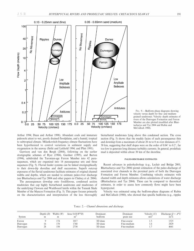
Velocity was estimated using the bedform-phase diagrams of Rubinand McCulloch (1980), who showed that specific bedforms (e.g., ripples
FIG. 9.—Bedform phase diagrams showingvelocity versus depth for fine- and medium-grained sandstones. Velocity–depth estimates ofrivers of the Dunvegan Formation and FerronMember are also plotted (modified after Bhat-tacharya and Tye 2004 and Rubin andMcCulloch 1980).
TABLE 2.—Channel dimensions and discharge.
SystemDepth (D)
mWidth (W)
mArea 0.65(W*D)
m2Dominantbedform
Dominantgrain size
Velocity (U)m/s2
Discharge Q5 A*Um3/s
Ferron 9 174 1017 3D dune Fine-coarse 1.5 1525Dunvegan 16 170 1768 3D dune Fine-medium 1.6 2829Dunvegan 28 150 2730 3D dune Fine-medium 1.7 4641
HYPERPYCNAL RIVERS AND PRODELTAIC SHELVES: CRETACEOUS SEAWAY 191J S R
and dunes) are stable within specific ranges of flow velocity, flow depth,and grain size (Fig. 9). Grain size, bedforms, and flow depth can all bedirectly measured or estimated from core or outcrop data, thus allowingvelocities to be estimated. For example, the observation of dominantlydune-scale cross-stratification within both systems can be used todetermine average flow velocities, provided that sediment caliber andwater depth are known.Within the clastic wedges examined, rivers confined to valleys are
candidates for the largest-scale trunk channels. In general, Mulder andSyvitsky (1995) show that the larger the river, the more difficult it is toproduce a hyperpycnal plume. We thus focus on estimating the dischargeof the largest rivers. If they fall within the range of rivers that easilyproduce hyperpycnal plumes, then we assume that the smaller rivers anddelta distributaries would have even greater propensity to generatehyperpycnal plumes.Details of channel and bar dimensions are readily available from
published facies architectural studies (e.g., Plint and Wadsworth 2003,Barton et al. 2004, Corbeanu et al. 2004, and Garrison and van den Bergh2004, 2006) and can be used to estimate channel widths and depths(Table 2).
Estimations of Discharge for Ferron and Dunvegan Rivers
Data from preserved story thicknesses, bar thicknesses, and dune-scalecross-set thicknesses suggest that the largest Ferron rivers were about 9 mdeep (Barton et al. 2004; Bhattacharya and Tye 2004; Corbeanu et al.2004; Garrison and van den Bergh 2004, 2006). The grain sizes of Ferronchannels vary between fine to medium sand, although pebbly sandstonesare found in the most proximal portions of some intervals. Widths ofchannels (as opposed to channel belts), as estimated from strike-orientedcliff exposures (Table 2), range from a few tens of meters to a maximumof 174 meters (Garrison and van den Bergh 2004, 2006). Channel beltsreach a maximum width of several kilometers.Plotting the Ferron data on the 3D bedform phase diagram of Rubin
and McCulloch (1980) suggests peak river flood velocities (U) of about1.5 m/s for the largest (9 m deep) channels (Fig. 9). A rectangular channelwould yield a maximum cross-channel area (A) of about 1500 m2 for the
largest (174 m wide) Ferron rivers. Given that the channels are curved,the actual area is probably closer to 0.65(A) 5 1000 m2 (Table 2).Corresponding discharge (Q 5 A 3 U) of the largest trunk Ferron riversis calculated to have been about 1500 m3/s. Given the tectonic andclimatic setting, coupled with the intermediate channel sizes, the Ferronrivers are predicted to have produced common hyperpycnal flows(Fig. 6).
Data on ancient rivers of the Dunvegan Formation (Bhattacharya1991; Plint and Wadsworth 2003) show trunk channel depths of about10 m, with widths of between 100 and 150 m, although a few larger riversup 28 m deep have been documented. The Simonette valley, an incisedtrunk river associated with the most highly river-dominated lobe withinAllomember E of the Dunvegan Formation (Bhattacharya 1991), shows amaximum thickness of about 15 meters, suggesting that flood-riverdepths were generally less than this. Subsurface isolith mapping showsthat the valleys ranged from 2 km to 5 km wide. Photomosaicinterpretation of a large tributary feeder valley to the Simonette Valley(Plint and Wadsworth 2003) shows a cross-sectional width of about170 m and a depth of about 16 m.
Sediment calibers within the lower reaches of the Simonette Valleyrange from fine- to medium-grained sand (except for intraformationalmud clasts, and shell and plant debris) and the dominant sedimentarystructure is dune-scale cross stratification. The Rubin and Mculloch(1980) plot suggests that velocities of , 1.6 m/s were likely (Fig. 9).Assuming a maximum cross-sectional width of about 170 m, a maximumwater depth of 16 m, and a velocity of 1.6 m/s, a discharge of 2829 m3/scan be estimated for the Simonette channel, which is somewhat largerthan that of the Ferron, but still lying within the range of rivers that arefrequently hyperpycnal (Fig. 6, Table 2). The average discharge volumesof the 10-m-deep, 150-m-wide rivers would be on the order of 1500 m3/s,similar to the largest Ferron rivers. Even the deepest Dunvegan riversshow a discharge of 4641 m3/s (Table 2).
Comparison of paleo-discharge estimates of both the Dunvegan andFerron rivers, using the criteria presented by Mulder and Syvitski (1995),indicates that both systems likely produced hyperpycnal plumes withsome regularity (Fig. 6). The generally humid climate and proximity (,
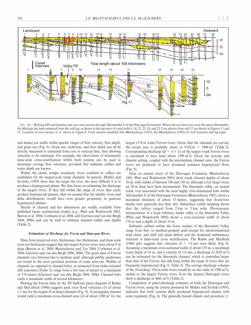
FIG. 10.—Well log (SP and Gamma) and core cross section through Allomember E of the Dunvegan Formation. Where the core does not cover the entire allomember,the lithology has been estimated from the well log, as shown in the top parts of cored wells 9, 14, 22, 23, 24, and 25. Core photos from well 17 are shown in Figures 11 and12. Location of cross section A–A9 shown in Figure 8. Cross sections modified after Bhattacharya (1993). See Bhattacharya (1993) for well locations and log types.
192 J.P. BHATTACHARYA AND J.A. MACEACHERN J S R

200 km) to an active mountain belt would also have enhanced the abilityof these rivers to achieve hyperpycnal states. The relatively small drainagebasins, which are an order of magnitude smaller than continental-scalerivers like the Mississippi and Ganges–Brahmaputra, would also haveameliorated the generation of hyperpycnal plumes (Bhattacharya and Tye2004; Mulder and Syvitsky 1995).
The shallow-ramp versus shelf–slope setting may also have resulted inbrackish-water conditions and estuarine mixing in the nearshore zone,and would have enhanced the ability of the rivers to produce hyperpycnalflows (Slingerland et al. 1996). Depending upon how reduced thenearshore salinities were, the ability of the larger Dunvegan Rivers togenerate hyperpycnal flows may have been enhanced by an alreadybrackish-water seaway.
Low slopes would certainly have inhibited the development of long-traveling, ignitive turbidity currents, but the generally stormy nature ofthe seaway, as indicated by the ubiquity of hummocky cross-stratificationin both shoreface and deltaic successions (e.g., Howard and Frey 1984;Pemberton and Frey 1984; Ryer 1984; Plint 1988; Frey 1990;Bhattacharya and Walker 1991a, 1991b; MacEachern and Pemberton1992; Pemberton and MacEachern 1997; Garrison and van den Bergh2004, 2006; van den Bergh and Garrison 2004), may have allowed stormsto maintain hyperpycnal flows, following the mechanisms suggested by
Bentley (2003), Wheatcroft (2000), Mutti et al. (2003), and Freidrichs andScully (2007).
DUNVEGAN AND FERRON RIVER-DOMINATED DELTA-FRONT AND
PRODELTA DEPOSITS
Dunvegan Facies
General descriptions of the prodelta and delta-front deposits of river-dominated deltas in the Dunvegan Formation were first described byBhattacharya and Walker (1991a) and Bhattacharya (1991). A standardgrain-size card was used to visually estimate grain sizes down to lowervery fine sandstone (62 microns). Silt and clay were visually estimated,based upon color and texture. The prodelta mudstones form units thatrange from a few tens of centimeters to as much as 20 meters thick(Figs. 4, 10, 11). The mudstones lie at the base of coarsening-upwardfacies successions (parasequences), which were interpreted as progradingfluvial- or storm/wave-dominated delta fronts and shorefaces (Figs. 4, 10,11). Originally, Bhattacharya and Walker (1991a, 1991b) interpretedthese mudstones to have formed as passive, suspension-sediment falloutdeposits.
In detail, the prodelta mudstone facies show an abundance ofcentimeter-thick, normally graded siltstone and very fine-grained
FIG. 11.—Core photos and measured section through prodelta and delta-front succession of well 17 in Figure 10. Core is read from base at lower left to top at upperright. Core location: Trilogy et al., Saxon well 16-10-61-25W5M, 2244–2262 m; lower 10 meters only is shown.
HYPERPYCNAL RIVERS AND PRODELTAIC SHELVES: CRETACEOUS SEAWAY 193J S R
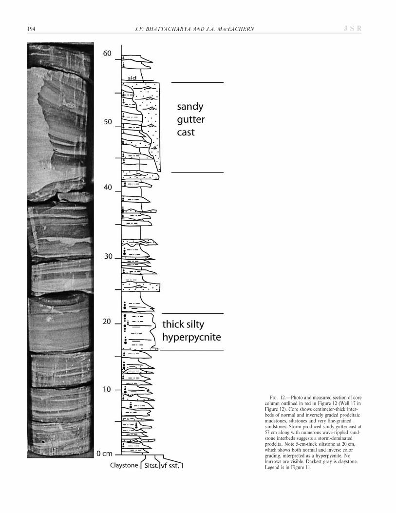
FIG. 12.—Photo and measured section of corecolumn outlined in red in Figure 12 (Well 17 inFigure 12). Core shows centimeter-thick inter-beds of normal and inversely graded prodeltaicmudstones, siltstones and very fine-grainedsandstones. Storm-produced sandy gutter cast at57 cm along with numerous wave-rippled sand-stone interbeds suggests a storm-dominatedprodelta. Note 5-cm-thick siltstone at 20 cm,which shows both normal and inverse colorgrading, interpreted as a hyperpycnite. Noburrows are visible. Darkest gray is claystone.Legend is in Figure 11.
194 J.P. BHATTACHARYA AND J.A. MACEACHERN J S R
sandstone beds (Figs. 11, 12, 13), virtually identical to those seen in somemodern examples (Fig. 7). Thicker siltstone and sandstone beds locallyshow rhythmic stratification (e.g., thick bed at 20 cm in Fig. 12 andFig. 13) similar to that described from Central Japan (Fig. 7B). Beds alsolocally show both inverse and normal grading, and internal scoursurfaces, suggesting deposition during waxing as well as waning flows(Figs. 12, 13). Sandstones may show wave-formed cross lamination and,locally, hummocky cross stratification, suggesting a linkage with majorstorms (Fig. 12).
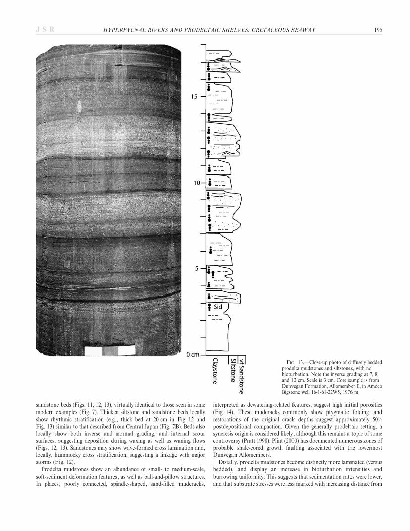
Prodelta mudstones show an abundance of small- to medium-scale,soft-sediment deformation features, as well as ball-and-pillow structures.In places, poorly connected, spindle-shaped, sand-filled mudcracks,
interpreted as dewatering-related features, suggest high initial porosities(Fig. 14). These mudcracks commonly show ptygmatic folding, andrestorations of the original crack depths suggest approximately 50%postdepositional compaction. Given the generally prodeltaic setting, asyneresis origin is considered likely, although this remains a topic of somecontroversy (Pratt 1998). Plint (2000) has documented numerous zones ofprobable shale-cored growth faulting associated with the lowermostDunvegan Allomembers.
Distally, prodelta mudstones become distinctly more laminated (versusbedded), and display an increase in bioturbation intensities andburrowing uniformity. This suggests that sedimentation rates were lower,and that substrate stresses were less marked with increasing distance from
FIG. 13.—Close-up photo of diffusely beddedprodelta mudstones and siltstones, with nobioturbation. Note the inverse grading at 7, 8,and 12 cm. Scale is 3 cm. Core sample is fromDunvegan Formation, Allomember E, in AmocoBigstone well 16-1-61-22W5, 1976 m.
HYPERPYCNAL RIVERS AND PRODELTAIC SHELVES: CRETACEOUS SEAWAY 195J S R
the active river plumes. Comparable relationships are apparent in modernexamples as well.
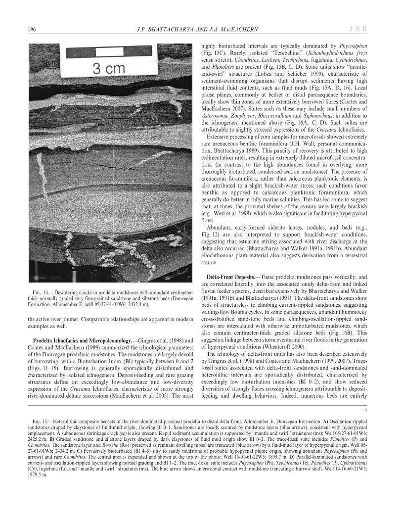
Prodelta Ichnofacies and Micropaleontology.—Gingras et al. (1998) andCoates and MacEachern (1999) summarized the ichnological parametersof the Dunvegan prodeltaic mudstones. The mudstones are largely devoidof burrowing, with a Bioturbation Index (BI) typically between 0 and 2(Figs. 11–15). Burrowing is generally sporadically distributed andcharacterized by isolated ichnogenera. Deposit-feeding and rare grazingstructures define an exceedingly low-abundance and low-diversityexpression of the Cruziana Ichnofacies, characteristic of more stronglyriver-dominated deltaic successions (MacEachern et al. 2005). The most
highly bioturbated intervals are typically dominated by Phycosiphon(Fig. 15C). Rarely, isolated ‘‘Terebellina’’ (Schaubcylindrichnus freyisensu stricto), Chondrites, Lockeia, Teichichnus, fugichnia, Cylindrichnus,and Planolites are present (Fig. 15B, C, D). Some units show ‘‘mantle-and-swirl’’ structures (Lobza and Schieber 1999), characteristic ofsediment-swimming organisms that disrupt sediments having highinterstitial fluid contents, such as fluid muds (Fig. 15A, D, 16). Localpause planes, commonly at bedset or distal parasequence boundaries,locally show thin zones of more extensively burrowed facies (Coates andMacEachern 2007). Suites such as these may include small numbers ofAsterosoma, Zoophycos, Rhizocorallium and Siphonichnus, in addition tothe ichnogenera mentioned above (Fig. 16A, C, D). Such suites areattributable to slightly stressed expressions of the Cruziana Ichnofacies.
Extensive processing of core samples for microfossils showed extremelyrare arenaceous benthic foraminifera (J.H. Wall, personal communica-tion, Bhattacharya 1989). This paucity of recovery is attributed to highsedimentation rates, resulting in extremely diluted microfossil concentra-tions (in contrast to the high abundances found in overlying, morethoroughly bioturbated, condensed-section mudstones). The presence ofarenaceous foraminifera, rather than calcareous planktonic elements, isalso attributed to a slight brackish-water stress; such conditions favorbenthic as opposed to calcareous planktonic foraminifera, whichgenerally do better in fully marine salinities. This has led some to suggestthat, at times, the proximal shelves of the seaway were largely brackish(e.g., West et al. 1998), which is also significant in facilitating hyperpycnalflows.
Abundant, early-formed siderite lenses, nodules, and beds (e.g.,Fig. 12) are also interpreted to support brackish-water conditions,suggesting that estuarine mixing associated with river discharge at thedelta also occurred (Bhattacharya and Walker 1991a, 1991b). Abundantallochthonous plant material also suggests derivation from a terrestrialsource.
Delta-Front Deposits.—These prodelta mudstones pass vertically, andare correlated laterally, into the associated sandy delta-front and linkedfluvial feeder systems, described extensively by Bhattacharya and Walker(1991a, 1991b) and Bhattacharya (1991). The delta-front sandstones showbeds of structureless to climbing current-rippled sandstones, suggestingwaning-flow Bouma cycles. In some parasequences, abundant hummockycross-stratified sandstone beds and climbing-oscillation-rippled sand-stones are intercalated with otherwise unbioturbated mudstones, whichalso contain centimeter-thick graded siltstone beds (Fig. 16B). Thissuggests a linkage between storm events and river floods in the generationof hyperpycnal conditions (Wheatcroft 2000).
The ichnology of delta-front units has also been described extensivelyby Gingras et al. (1998) and Coates and MacEachern (1999, 2007). Trace-fossil suites associated with delta-front sandstones and sand-dominatedheterolithic intervals are sporadically distributed, characterized byexceedingly low bioturbation intensities (BI 0–2), and show reduceddiversities of strongly facies-crossing ichnogenera attributable to deposit-feeding and dwelling behaviors. Indeed, numerous beds are entirely
FIG. 14.—Dewatering cracks in prodelta mudstones with abundant centimeter-thick normally graded very fine-grained sandstone and siltstone beds (DunveganFormation, Allomember E, well 05-27-61-01W6; 2432.4 m).
R
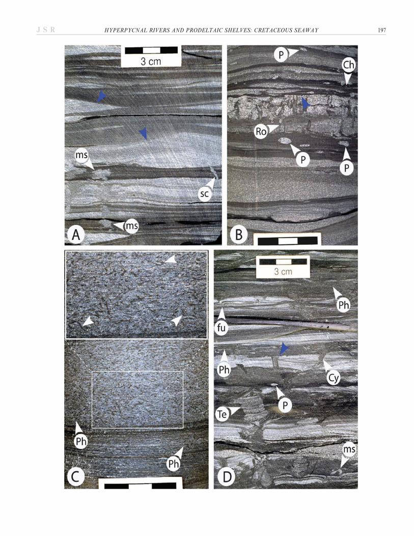
FIG. 15.—Heterolithic composite bedsets of the river-dominated proximal prodelta to distal delta front, Allomember E, Dunvegan Formation. A) Oscillation-rippledsandstones draped by claystones of fluid-mud origin, showing BI 0–1. Sandstones are locally scoured by mudstone layers (blue arrows), consistent with hyperpycnalemplacement. A subaqueous shrinkage crack (sc) is also present. Rapid sediment accumulation is supported by ‘‘mantle and swirl’’ structures (ms); Well 05-27-61-01W6;2425.2 m. B) Graded sandstone and siltstone layers draped by dark claystones of fluid mud origin show BI 0–2. The trace-fossil suite includes Planolites (P) andChondrites. The sandstone layer and Rosselia (Ro) (preserved as remnant dwelling tubes) are truncated (blue arrow) by a fluid-mud layer of hyperpycnal origin, Well 05-27-61-01W6; 2434.2 m. C) Pervasively bioturbated (BI 4–5) silty to sandy mudstone of probable hypopycnal plume origin, showing abundant Phycosiphon (Ph andarrows) and rare Chondrites. The central area is expanded and shown at the top of the photo; Well 16-01-61-22W5; 1899.7 m. D) Parallel-laminated sandstones withcurrent- and oscillation-rippled layers showing normal grading and BI 1–2. The trace-fossil suite includes Phycosiphon (Ph), Teichichnus (Te), Planolites (P), Cylindrichnus(Cy), fugichnia (fu), and ‘‘mantle and swirl’’ structures (ms). The blue arrow shows an erosional contact with mudstone truncating a burrow shaft. Well 14-16-60-21W5;1979.5 m.
196 J.P. BHATTACHARYA AND J.A. MACEACHERN J S R
HYPERPYCNAL RIVERS AND PRODELTAIC SHELVES: CRETACEOUS SEAWAY 197J S R
devoid of bioturbation. Uncommon but persistent ichnogenera includeRosselia, Ophiomorpha, Thalassinoides, Palaeophycus, Teichichnus, Cylin-drichnus, and Macaronichnus. Fugichnia are commonly associated withevent beds.
The delta-front systems show, through the integration of ichnology andsedimentology, that sedimentation rates were high and that depositionwas episodic, leading to a highly stressed benthic regime (e.g.,MacEachern et al. 2005). Turbid water columns above otherwise sandysubstrates likely operated to preclude filter-feeding and suspension-feeding organisms, leading to a paucity of Skolithos Ichnofacies elements(e.g., Moslow and Pemberton 1988; Gingras et al. 1998; Coates andMacEachern 1999, 2007).
Ferron–Tununk Facies
The delta-front sandstones of the Ferron Member overlie thick, age-equivalent prodelta shales of the Tununk Member (Fig. 17). Cores andoutcrops through the river- to wave- and storm-dominated parasequencesof the Ferron–Tununk show meters-thick units of weakly and sporad-ically bioturbated (BI 0–2) silty mudstones, particularly in the basal,fluvially dominated units (Figs. 18, 19). These mudstones are character-ized by abundant, centimeter-thick, normally graded siltstone toclaystone couplets (Figs. 19, 20). Inversely graded sandstone and siltstonebeds are observed locally (Fig. 21). Sandstone beds within the prodeltaalso contain aggradational current-ripple and oscillation-ripple lamina-tion, as well as distal or low-density Bouma sequences (e.g., Tbce and Tce
beds) (Fig. 22). Allochthonous plant material is ubiquitous.
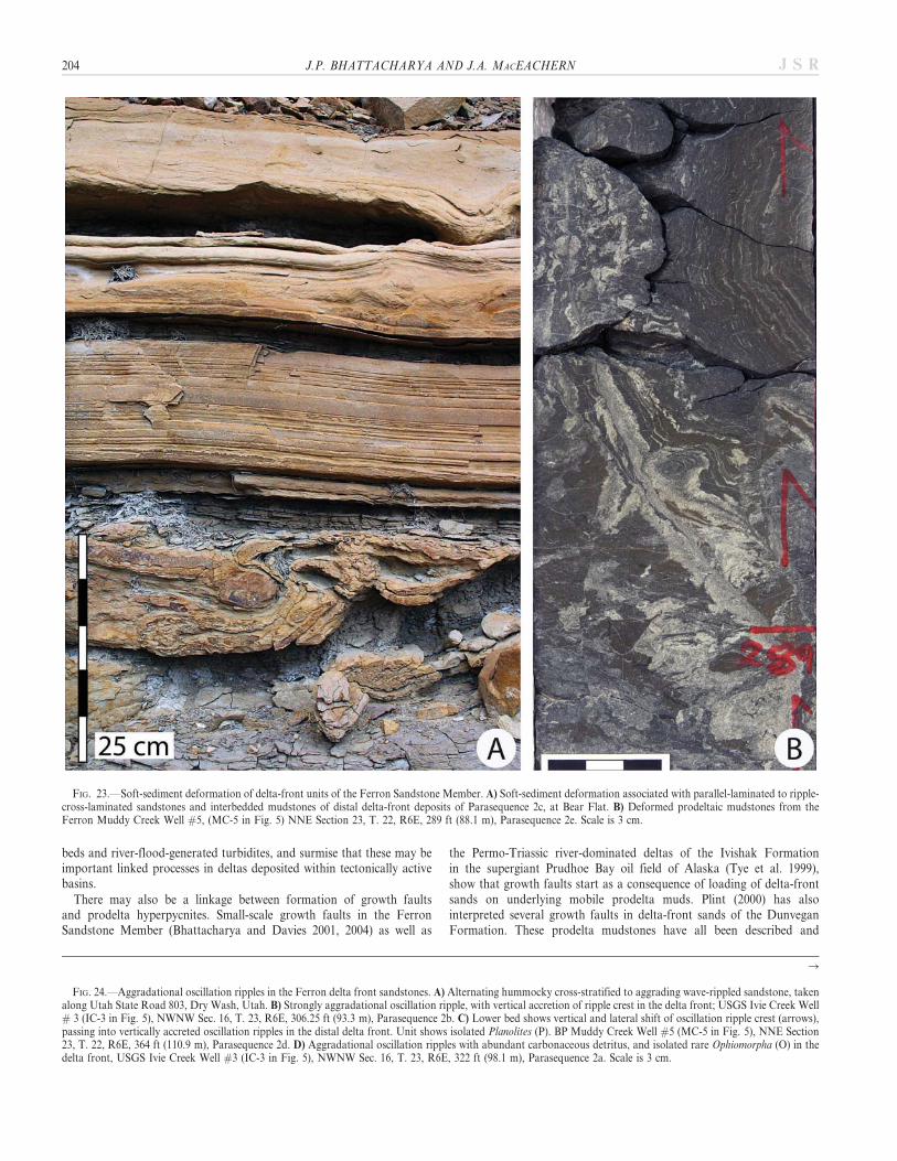
These mudstones locally display abundant soft-sediment deformationfeatures at a variety of scales, particularly in the more river-dominatedparasequences (Fig. 23). These are typified by convolute bedding andloading structures, and are overlain by small-scale growth faults, whichare particularly common in the lower Ferron parasequences. Accommo-dation of the growth strata is created by deformation of the underlyingprodelta muds, which are inferred to have had high initial porosities, andthus were easily mobilized (Bhattacharya and Davies 2001, 2004). This,again, suggests a setting prone to high sediment accumulation rates andhighly stressed substrate conditions, interpreted to be indicative ofhyperpycnal conditions.
Prodelta Ichnofacies.—The prodeltaic units show low bioturbationintensities (BI 0–2) with ichnogenera that are sporadically distributed(MacEachern et al. 2007b; Pemberton et al. 2007). Many intervals aredevoid of bioturbation (Figs. 19, 20). Trace fossils occur in low numbersand consist mainly of diminutive and isolated Planolites, Palaeophycus,Thalassinoides, Chondrites, and fugichnia, with small amounts ofPhycosiphon (Fig. 21). Trace fossil suites are broadly similar to, thoughmore impoverished than, those observed in the Dunvegan Formation.The low diversity and reduced abundance of trace fossils are thought toindicate strong fluvial domination of the delta lobe and more persistentlystressed conditions. The predominance of strongly facies-crossing
ichnogenera, their diminutive sizes, and the concomitant abundance ofsiderite nodules within the prodeltaic intervals suggest that brackish-water conditions may have been a major source of environmental stress,in addition to high sedimentation rates. Along strike, these brackish-water indicators decrease, and trace-fossil diversities increase (e.g., Kf-1-Iv[a] Parasequence of Anderson et al. 2004 and Parasequence 1F ofGarrison and van den Bergh 2004, in the Ivie Creek #11 core,MacEachern et al. 2007b).
Delta-Front Deposits.—The prodelta deposits pass into delta-frontturbidites, interpreted to be related to river floods (Bhattacharya andDavies 2004). The presence of steeply inclined (up to 15u) delta-frontstrata within the Ferron Member (such as in the Kf-1-Iv Parasequence ofAnderson et al. 2004; their fig. 11 and Parasequence 1F of Garrison andvan den Bergh 2004, Fig. 5) also indicates rapid deposition, probablyduring river flood events. These steep slopes should have been capable ofgenerating initially autosuspending (ignitive?) hyperpycnal flows, al-though wave and tidal forcing is likely required for the associatedsediments to migrate along the significantly lower-gradient shelf.
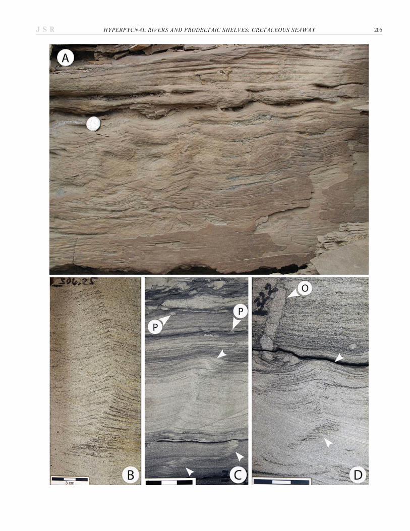
Sandstone beds showing hummocky cross-stratification and oscillationripples are also intercalated with the otherwise rather more fluviallydominated delta-front units (characterized by low bioturbation intensitiesand a predominance of graded beds) as described above for the Dunvegandelta-front deposits. This also supports a linkage between river floods andmajor storms (Wheatcroft 2000). Indeed, the abundant decimeter-thicksets of nearly vertically climbing aggradational oscillation-ripple-lami-nated sandstones suggests that storm waves reworked the delta frontsimultaneously with rapid deposition (Fig. 24), although post-floodreworking by storm waves may also have occurred.
Delta-front sandstones show BI 0–2, with isolated, predominantly facies-crossing elements such as Palaeophycus, Ophiomorpha, Thalassinoides, andTeichichnus (Fig. 21), as well as uncommon Diplocraterion and Skolithos.Interlaminae of mudstone and siltstone are common, and locally containPlanolites, as well as very rare Chondrites and Phycosiphon.
The reduced bioturbation intensities support high deposition rates. Thepaucity of dwelling structures of inferred suspension-feeding organisms inotherwise sandy depositional media is consistent with heightened waterturbidity (Moslow and Pemberton 1988; Gingras et al. 1998; Coates andMacEachern 1999, 2007; MacEachern et al. 2005); such conditions tendto be maximized in strongly river-dominated deltaic lobes. The diminutivenature of most of the ichnogenera and the strongly facies-crossingcharacter of the trace-fossil suite also supports generally reduced-salinityconditions.
GENERAL INTERPRETATION AND COMPARISON OF MODERN AND ANCIENT
MUDDY HYPERPYCNITES
The prodelta mudstones associated with the Dunvegan Formation andFerron Member, as described above, show a number of features identicalto those reported from modern settings (Fig. 7), including both the
R
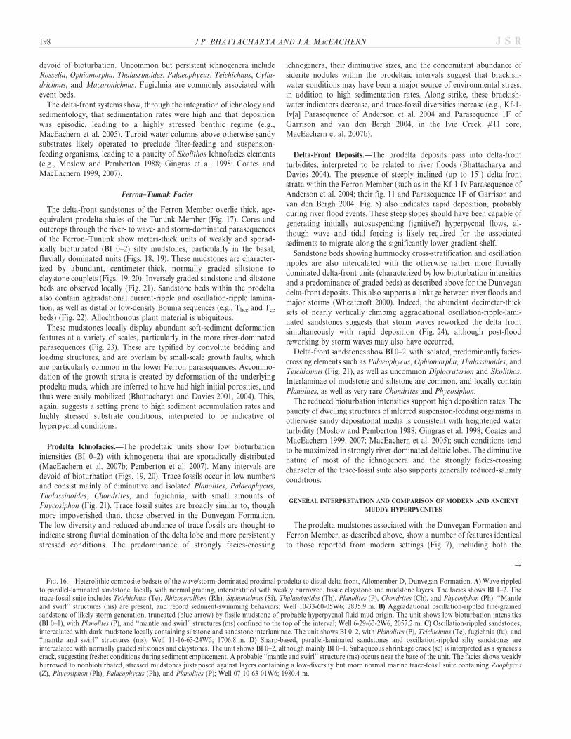
FIG. 16.—Heterolithic composite bedsets of the wave/storm-dominated proximal prodelta to distal delta front, Allomember D, Dunvegan Formation. A) Wave-rippledto parallel-laminated sandstone, locally with normal grading, interstratified with weakly burrowed, fissile claystone and mudstone layers. The facies shows BI 1–2. Thetrace-fossil suite includes Teichichnus (Te), Rhizocorallium (Rh), Siphonichnus (Si), Thalassinoides (Th), Planolites (P), Chondrites (Ch), and Phycosiphon (Ph). ‘‘Mantleand swirl’’ structures (ms) are present, and record sediment-swimming behaviors; Well 10-33-60-05W6; 2835.9 m. B) Aggradational oscillation-rippled fine-grainedsandstone of likely storm generation, truncated (blue arrow) by fissile mudstone of probable hyperpycnal fluid mud origin. The unit shows low bioturbation intensities(BI 0–1), with Planolites (P), and ‘‘mantle and swirl’’ structures (ms) confined to the top of the interval; Well 6-29-63-2W6, 2057.2 m. C) Oscillation-rippled sandstones,intercalated with dark mudstone locally containing siltstone and sandstone interlaminae. The unit shows BI 0–2, with Planolites (P), Teichichnus (Te), fugichnia (fu), and‘‘mantle and swirl’’ structures (ms); Well 11-16-63-24W5; 1706.8 m. D) Sharp-based, parallel-laminated sandstones and oscillation-rippled silty sandstones areintercalated with normally graded siltstones and claystones. The unit shows BI 0–2, although mainly BI 0–1. Subaqueous shrinkage crack (sc) is interpreted as a syneresiscrack, suggesting freshet conditions during sediment emplacement. A probable ‘‘mantle and swirl’’ structure (ms) occurs near the base of the unit. The facies shows weaklyburrowed to nonbioturbated, stressed mudstones juxtaposed against layers containing a low-diversity but more normal marine trace-fossil suite containing Zoophycos(Z), Phycosiphon (Ph), Palaeophycus (Ph), and Planolites (P); Well 07-10-63-01W6; 1980.4 m.
198 J.P. BHATTACHARYA AND J.A. MACEACHERN J S R
HYPERPYCNAL RIVERS AND PRODELTAIC SHELVES: CRETACEOUS SEAWAY 199J S R

deeper-water hyperpycnites (e.g., Nakajima 2006) as well as shallow-water examples from the Atchafalaya (Neill and Allison 2005) and Eelrivers (Bentley and Nittrouer 2003). They also show many similarities tothe hyperpycnite facies model of Mulder et al. (2003) (Fig. 2). Theabundance of diffusely bedded, centimeter- to decimeter-thick intervals ofmassive to stratified siltstones and very fine-grained sandstones,especially coupled with occurrences displaying both inverse and normalgrading, suggest deposition by waxing and waning hyperpycnal flows.The general paucity of burrowing and abundant soft-sediment deforma-tion are consistent with rapid sediment emplacement, possibly as high astens of centimeters per year. The recurrence of strongly facies-crossingdiminutive ichnogenera reflects opportunistic organisms inhabiting ahighly stressed and at least periodically brackish-water setting. Suchconditions are compatible with inundation of fresh- to brackish-waterhyperpycnal plumes at the seafloor. The predominance of simple facies-crossing structures also suggests an endobenthos dominated by trophicgeneralists (cf. Beynon et al. 1988; Pemberton and Wightman 1992), inwhich short-lived species flourish intermittently between seasonal riverflood events. Some hyperpycnal layers occur closely stacked and areassociated with possible syneresis cracks, suggesting that these may befreshet-driven flood event beds. These conditions may have led to short-lived periods of salinity reduction near the bed, followed by a return tofully marine deposition (e.g., Dunvegan Allomember E and AllomemberD). Alternatively, an embayed portion of the coast may see persistentsalinity reduction in that portion of the basin, and prolonged periods ofbrackish-water deposition; such a scenario appears likely for the river-dominated lower cycle of the Ferron Sandstone (Bhattacharya andDavies 2004). In either event, seasonal river discharge probably served tofacilitate hyperpycnal plumes. Early flood events may have reduced thesalinity of the embayment, making it easier for successive floods toachieve hyperpycnal conditions. Such ‘‘prepping’’ may explain theoccurrence of numerous hyperpycnites stacked one upon another.
The common observation of wave ripples and hummocky crossstratification suggests that many of these hyperpycnites were linked tolarge storms, thought to have been very common in the CretaceousSeaway. Given the generally small scale of the Ferron and Dunvegandrainage basins (100 to 200 km in length), large hurricanes and tropicalstorms, modern examples of which average between 160 to 1000 km indiameter, would have routinely affected both drainage basin andnearshore shelf at the same time. The rivers would have experiencedmajor flooding and would have deposited this sediment across asimultaneously very stormy shelf.
Distinguishing Anoxic Laminites from Graded Hyperpycnites
Apparently unburrowed laminated black mudstones are a commonfeature of the Cretaceous interior, and are commonly associated withoceanic anoxic events (Laurin and Sageman 2007). As a consequence, apaucity of burrowing and the presence of laminated mudstones are notsufficient evidence of ancient hyperpycnites (Table 3).
Reductions in bioturbation intensities or the absence of burrowingwithin mudstones certainly may result from dysaerobic or anoxicconditions (e.g., Rhoads and Morse 1971; Bromley and Ekdale 1984;Savrda and Bottjer 1987; Wignall 1991; Savrda 1992, 1995; Wignall andPickering 1993; Martin 2004). Anoxic laminites generally display anabundance of pelagic constituents, such as authigenic organic matter andcalcareous microfossils, thanatocoenoses composed of nektonic andpelagic organisms, and a general absence of benthic fauna, suggesting farlower sedimentation rates than are inferred for the hyperpycnal units(Table 3). In the Cretaceous, such organic-rich mudstone laminitescontain abundant fecal pellets and fossiliferous debris (Sethi and Leithold1994), including fish remains as well as calcareous microfossils. Pyrite andother minerals indicative of reducing conditions are also common. TheWhite Speckled Shale in the Alberta Basin, the Mowry Shale in the USWestern Interior, and, of course, the Fish Scale Zone described above areexamples.
The abundance of graded beds, siltstone and sandstone interlaminae,heterolithic composite bedsets, and low organic contents suggest thatreduced oxygenation was not a significant stress in the prodeltaicmudstones of the Dunvegan Formation and the Ferron Memberdescribed above. Emplacement of such clastic layers within the mudstoneswould have occurred under conditions of traction transport or waveagitation. Storm waves, sediment-gravity flows, and tidal currents wouldhave operated to introduce oxygenated water to the substrate. The‘‘mantle and swirl’’ structures record the activity of sediment-swimmingorganisms (particularly polychaete worms) that swim through fluid mud(Lobza and Schieber 1999; Schieber 2003). Barrett and Schieber (1999)showed that it can take from days to weeks for a fluid mud to self-compact to such a degree that it effectively precludes sediment swimming.However, these subtle ‘‘mantle and swirl’’ structures (e.g., Figs. 15A, D,16) preclude the interpretation of anoxic conditions at the bed (Schieber2003).
Most of the organic debris within the prodelta mudstones of theDunvegan Formation and Ferron Member delta systems consist ofallochthonous terrestrial plant debris rather than marine algal organicmaterial commonly found in anoxic laminites. Micropaleontological
FIG. 17.—Photo of the Ferron delta-frontsandstones overlying thick, prodeltaic mudstonesof the Tununk Shale Member, Last ChanceDelta Complex. View from Bear Gulch lookingeast across the Miller Canyon Road (located inFig. 5B).
200 J.P. BHATTACHARYA AND J.A. MACEACHERN J S R

collections of prodeltaic and muddy shelf deposits likewise consist ofmainly arenaceous benthic foraminifera and an absence of pelagicelements, which also suggests an oxygenated substrate (e.g., MacEachernet al. 1999; Stelck et al. 2000).
MacEachern et al. (1999) also argued that some apparently unbur-rowed dark mudstones may reflect a taphonomic bias, imparted by apredominance of surface grazing fecal trails and mud-filled burrows thatlack lithologic contrast with the host sediment, making them challengingto discern. Using photo-enhancement, SEM work, and large-format thin
sections, Schieber (2003) showed that many laminated and apparentlyblack shales thought to record anoxic conditions actually display evidenceof persistent, millimeter-scale bioturbation forming a ‘‘burrow-laminatedfabric.’’ Casual inspection of dark mudstones, such as is typically done inroutine core description, typically overlooks such subtle evidence ofbioturbation.
From a taphonomic perspective, the prodeltaic mudstones of theDunvegan and Ferron systems described above display well-developednormal and inverse graded beds, delicate siltstone and sandstone laminaeand thin beds, and locally high interstitial silt contents. Such facies showfar too much lithologic variability to obscure significant proportions ofthe ichnological suite. Disruptions of interlaminae and burrowed tops tobeds are readily apparent where they occur, and the similar beds thatappear unburrowed almost certainly never were.
Salinity Stresses and Comparison with Hypopycnal Deltas and NormalMarine Shelves
Although we have generally interpreted the deltas of the FerronMember and Dunvegan Formation to reflect hyperpycnal conditions, theprodelta mudstones in both units include ichnogenera attributed toorganisms regarded to be generally intolerant of salinity reductions,particularly Phycosiphon, Helminthopsis, Zoophycos, Chondrites, Aster-osoma, Scolicia, and Rhizocorallium (e.g., Coates and MacEachern 1999,
FIG. 18.— Ferron Sandstone measured along Muddy Creek, through Para-sequence 2c in Figure 5 (see Bhattacharya and Davies 2004 for more details).Prograding prodelta mudstones downlap onto bioturbated shelf deposits at about13.5 m in the section.
FIG. 19.—A) Laminated to B) thin-bedded prodelta mudstones of the TununkShale. These shales comprise the prodeltaic equivalents of the Ferron SandstoneMember. Note the pristine physical sedimentary structures, bedded character, andpaucity of bioturbation.
HYPERPYCNAL RIVERS AND PRODELTAIC SHELVES: CRETACEOUS SEAWAY 201J S R
2007; Bann et al. 2004; MacEachern et al. 2005, 2007a; MacEachern et al.2007b), although these are sporadically distributed and commonly occurat parasequence boundaries and bed tops that represent pauses indeposition. This suggests that there were marked salinity fluctuations andprobable alternations between normal marine and brackish-waterconditions.
Markedly reduced salinities induce depauperate ichnological suiteswith a predominance of diminutive, strongly facies-crossing ichnogenera(e.g., Milne 1940; Levinton 1970; Remane and Schlieper 1971; Perkins1974; Dorjes and Howard 1975; Howard and Frey 1975; Pembertonand Wightman 1992; Sethi and Leithold 1994; Gingras et al. 1999).MacEachern and Gingras (2008) have summarized a range of brackish-water inshore settings, wherein strongly reduced salinities show lowbioturbation intensities and monospecific ichnological suites. Salinitiesmust approach , 5% before wholesale depopulation occurs (cf. Gingraset al. 1999), and such conditions are unlikely to occur in a marine basin,even where hyperpycnal flows occur. Indeed, many brackish-water faciesactually show very high bioturbation intensities, albeit characterized byvery low diversities (e.g., Beynon et al. 1988; Pemberton and Wightman1992; Gingras et al. 1999; MacEachern and Gingras 2008). Brackish-water suites tend to show specific combinations of ichnogenera. Facies-crossing elements such as Planolites, Teichichnus, Thalassinoides, Cylin-drichnus, Rosselia, Ophiomorpha, ‘‘Terebellina,’’ and Palaeophycus arecommon to both the prodeltaic and inshore brackish-water settings.Persistently brackish-water regimes, however, commonly have Gyrolithes,Skolithos, Arenicolites, Gastrochaenolites, Lingulichnus, and Lockeia as
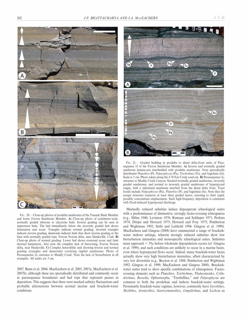
FIG. 20.—Close-up photos of prodelta mudstones of the Tununk Shale Memberand lower Ferron Sandstone Member. A) Close-up photo of centimeter-scale,normally graded siltstone to claystone beds. Inverse grading can be seen inuppermost beds. The bed immediately below the inversely graded bed showslamination and scour. Triangles indicate normal grading, inverted trianglesindicate inverse grading, diamonds indicate beds that show inverse grading at thebase with normally graded tops. Ferron Notom delta, near Hanksville, Utah. B)Close-up photo of normal grading. Lower bed shows erosional scour and faintinternal lamination. Also note the complete lack of burrowing. Ferron Notomdelta, near Hanksville. C) Complex heterolithic unit showing inverse and normalgrading (triangles and diamonds) overlying rippled sandstones. Photo ofParasequence 2c, entrance to Muddy Creek. Note the lack of bioturbation in allexamples. All scales are 3 cm.
FIG. 21.— Graded bedding in prodelta to distal delta-front units of Para-sequence 1f of the Ferron Sandstone Member. A) Inverse and normally gradedsandstone lamina-sets interbedded with prodelta mudstones. Note sporadicallydistributed Planolites (P), Palaeophycus (Pa), Teichichnus (Te), and fugichnia (fu).Scale is 3 cm. Photo taken along the I-70 Ivie Creek road-cut. B) Parasequence 2c,entrance to Muddy Creek Canyon. Stacked normally graded sandstones, inverselygraded sandstones, and normal to inversely graded sandstones of hyperpycnalorigin, with a sideritized mudstone interbed from the distal delta front. Tracefossils include Palaeophycus (Pa), Planolites (P), and fugichnia (fu). Note that theescape structure transects at least three graded layers, attesting to their rapid,possibly concomitant emplacement. Such high-frequency deposition is consistentwith flood-induced hyperpycnal discharge.
202 J.P. BHATTACHARYA AND J.A. MACEACHERN J S R
associated ichnogenera (e.g., MacEachern and Gingras 2008). Suchindicators of persistently brackish-water conditions are largely absent inthe facies described in this study, suggesting that the deltas consistentlyalternated between normal and brackish-water (i.e., probably hyperpyc-nal) conditions.
The combination of sedimentological and ichnological characteristicsobserved in the prodelta mudstones associated with the Dunvegan andFerron deltas indicate that these facies were emplaced episodically andrapidly. High depositional rates lead to general reductions in bioturbationintensities. Where sedimentation rates exceed recolonization ratesassociated with larval recruitment, thick intervals may be largely devoidof endobenthic communities. The micropaleontological analyses inde-pendently support this as a principal cause of faunal impoverishment, asindicated by the small numbers of exclusively arenaceous benthicforaminifera, faunal expressions consistent with rapid deposition. Rapiddeposition, coupled with associated (though subordinate) stressesoperating in the prodelta setting lead to ichnological characteristicsdistinctive of deltaic regimes (MacEachern et al. 2005; MacEachern et al.2007a). These stresses include short-lived salinity fluctuations related tofreshet conditions and/or river flood stages, episodic heightened waterturbidity due to hyperpycnal and/or hypopycnal river plumes, and
periodic oxygenation reductions associated with breakdown of terrestri-ally derived phytodetritus.
Mudstones associated with hypopycnal conditions may show signifi-cantly higher abundances and diversities of ichnofauna (MacEachern etal. 2005). In such settings, mud flocculation from buoyant mud plumescreates a regime wherein mudstone deposition rates are more uniform(less episodic) and generally slower than in their hyperpycnal counter-parts. Such mudstones may be more thoroughly burrowed, show shallow-tier (e.g., Phycosiphon, Planolites, and Teichichnus) as well as deep-tierstructures (e.g., Rosselia, Cylindrichnus, Ophiomorpha, Thalassinoides,Chondrites, and Zoophycos), and display wider ranges of organismethology, though dominated by structures indicative of deposit-feedingand grazing behaviors. Sediment-swimming organisms are probably lessabundant in hypopycnal-dominated systems, although they may bepresent where thicker fluid-mud beds are emplaced due to rapid mixing ofstorm/flood-related buoyant mud plumes with basinal waters, whichheightens the rate of clay flocculation. In contrast to the nondeltaicoffshore zones, however, even these suites remain impoverished,dominated by facies-crossing ichnological elements, and a paucity ofsuspension- and filter-feeding structures due to greater than optimalwater turbidity (e.g., Moslow and Pemberton 1988; Gingras et al. 1998;Coates and MacEachern 1999, 2007; Bann and Fielding 2004; Mac-Eachern et al. 2005; MacEachern et al. 2007a).
On the shelf, deltaic overprint (acting as the principal source ofsediment) is readily apparent. Shelf settings that experience neitherhypopycnal nor hyperpycnal processes are characterized by heightenedcarbonate production and an increase in nektonic and planktoniccalcareous microfauna. Bioturbation intensities tend to be high, withunstressed, fully marine ichnological suites showing a complex overprintof successive tiers. By contrast, shale-dominated ‘‘shelf’’ mudstonesdisplaying a strong prodeltaic overprint are characterized by impover-ished microfauna limited mainly to arenaceous benthic foraminifera,show sediment-swimming structures, sporadically distributed burrowing,generally reduced bioturbation intensities, and lower trace-fossil diversi-ties that nonetheless comprise both facies-crossing elements andichnogenera characteristic of normal marine conditions.
IMPORTANCE OF PRODELTA HYPERPYCNITES
Hyperpycnal processes are suggested to be significant in deposition ofmany of the shale units in the Cretaceous Seaway. Such hyperpycnalturbidites may be directly fed by rivers, producing hyperpycnites similarto those shown in the models of Mulder et al. (2003), but they may alsoevolve from collapsing hypopycnal plumes forming associated mud belts,especially where aided by storms, waves, tides, and other marine currents.
Other examples of river-fed ancient muddy prodelta hyperpycnitesinclude the Cretaceous Lewis shale in Wyoming (Soyinka and Slatt 2008),the Lower Kenilworth, and the Storrs and Aberdeen members of theBlackhawk Formation in the Book Cliffs of central Utah (Pattison 2005;Pattison et al. 2007), which also form part of the upper Mancos ShaleFormation. Although river-fed hyperpycnal processes were not invoked,a recent study by Varban and Plint (2008) of the Kaskapau shales, whichlie directly above the Dunvegan, suggests that they represent a long-livedprodelta-shallow shelf mudbelt, in which mud was transported as much as250 km offshore across a shallow gradient shelf ramp. The transportmechanisms invoked are very similar to those suggested by Bentley(2003), in which storm waves resuspended shelf mud, forming a sea-floornepheloid, fluid-mud layer that was subsequently dispersed by wind-driven currents (Fig. 1B). Mutti et al. (2003) has also summarized theimportance of river-generated hyperpycnal processes in combination withmajor storms in the deposition of sediment within delta-front andprodelta deposits of the European foreland basins. Mutti et al. (2003) alsosuggest a linkage between the generation of thick, storm-generated HCS
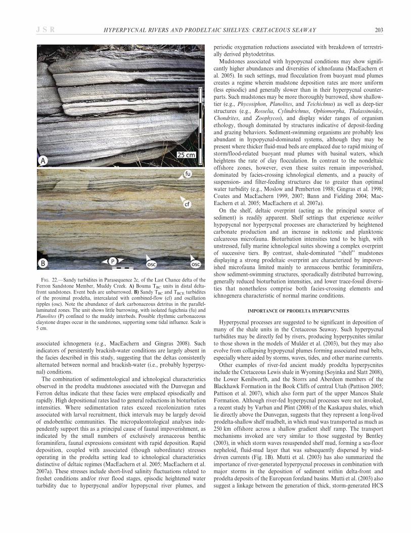
FIG. 22.—Sandy turbidites in Parasequence 2c, of the Last Chance delta of theFerron Sandstone Member, Muddy Creek. A) Bouma TBC units in distal delta-front sandstones. Event beds are unburrowed. B) Sandy TBC and TBCE turbiditesof the proximal prodelta, intercalated with combined-flow (cf) and oscillationripples (osc). Note the abundance of dark carbonaceous detritus in the parallel-laminated zones. The unit shows little burrowing, with isolated fugichnia (fu) andPlanolites (P) confined to the muddy interbeds. Possible rhythmic carbonaceousclaystone drapes occur in the sandstones, supporting some tidal influence. Scale is5 cm.
HYPERPYCNAL RIVERS AND PRODELTAIC SHELVES: CRETACEOUS SEAWAY 203J S R
beds and river-flood-generated turbidites, and surmise that these may beimportant linked processes in deltas deposited within tectonically activebasins.
There may also be a linkage between formation of growth faultsand prodelta hyperpycnites. Small-scale growth faults in the FerronSandstone Member (Bhattacharya and Davies 2001, 2004) as well as
the Permo-Triassic river-dominated deltas of the Ivishak Formationin the supergiant Prudhoe Bay oil field of Alaska (Tye et al. 1999),show that growth faults start as a consequence of loading of delta-frontsands on underlying mobile prodelta muds. Plint (2000) has alsointerpreted several growth faults in delta-front sands of the DunveganFormation. These prodelta mudstones have all been described and
FIG. 23.—Soft-sediment deformation of delta-front units of the Ferron Sandstone Member. A) Soft-sediment deformation associated with parallel-laminated to ripple-cross-laminated sandstones and interbedded mudstones of distal delta-front deposits of Parasequence 2c, at Bear Flat. B) Deformed prodeltaic mudstones from theFerron Muddy Creek Well #5, (MC-5 in Fig. 5) NNE Section 23, T. 22, R6E, 289 ft (88.1 m), Parasequence 2e. Scale is 3 cm.
R
FIG. 24.—Aggradational oscillation ripples in the Ferron delta front sandstones. A) Alternating hummocky cross-stratified to aggrading wave-rippled sandstone, takenalong Utah State Road 803, Dry Wash, Utah. B) Strongly aggradational oscillation ripple, with vertical accretion of ripple crest in the delta front; USGS Ivie Creek Well# 3 (IC-3 in Fig. 5), NWNW Sec. 16, T. 23, R6E, 306.25 ft (93.3 m), Parasequence 2b. C) Lower bed shows vertical and lateral shift of oscillation ripple crest (arrows),passing into vertically accreted oscillation ripples in the distal delta front. Unit shows isolated Planolites (P). BP Muddy Creek Well #5 (MC-5 in Fig. 5), NNE Section23, T. 22, R6E, 364 ft (110.9 m), Parasequence 2d. D) Aggradational oscillation ripples with abundant carbonaceous detritus, and isolated rare Ophiomorpha (O) in thedelta front, USGS Ivie Creek Well #3 (IC-3 in Fig. 5), NWNW Sec. 16, T. 23, R6E, 322 ft (98.1 m), Parasequence 2a. Scale is 3 cm.
204 J.P. BHATTACHARYA AND J.A. MACEACHERN J S R
HYPERPYCNAL RIVERS AND PRODELTAIC SHELVES: CRETACEOUS SEAWAY 205J S R

interpreted as rapidly deposited and probably hyperpycnal in origin.Certainly, the extremely high sedimentation rates described in modernhyperpycnal prodelta muds would result in elevated initial porosities andthe development of soupy substrates susceptible to remobilization. Wethus hypothesize that prodelta hyperpycnites may be important in thedevelopment of mobile substrates, especially in river- and storm-dominated deltas.In general, prodelta hyperpycnites likely may also form leaner, gas-
prone source rocks (i.e., type III kerogen) that are prone to the generationof overpressure, versus more slowly deposited, organic-rich, anoxiclaminites and condensed-section shales that typically contain Type I andII kerogens (Varban and Plint 2008).
CONCLUSIONS
N Delta systems deposited in the Ferron Sandstone Member of Utahand Dunvegan Formation in Alberta in the Cretaceous WesternInterior Seaway of North America show evidence of abundant,prodeltaic muddy ‘‘hyperpycnites.’’ These mudstones show diffuselybedded, centimeter-thick, normally to inversely graded siltstone andvery fine-grained sandstone beds, with internal scours, suggestingdeposition during waxing as well as waning hyperpycnal flows.Sandstones may show wave-formed cross lamination and, locally,hummocky cross stratification, suggesting a linkage with majorstorms. A depauperate fauna, and the presence of ‘‘mantle and swirl’’sediment-swimming structures also suggest rapidly deposited fluidmuds.
N Simple paleohydraulic calculations of the feeding rivers in theDunvegan Formation and Ferron Member show that paleo-riverdischarges never exceeded the 6000 m3/s theoretical threshold, abovewhich rivers seldom generate hyperpycnal plumes. We thus believethat these rivers routinely generated hyperpycnal plumes. Hyperpyc-nal conditions are ameliorated by the fact that the rivers are relativelysmall and drained an active mountain belt, within humid temperate(Dunvegan Formation) to subtropical (Ferron Sandstone Member)‘‘greenhouse’’ conditions. Local freshening and estuarine mixing inthe shallow coastal areas would have enhanced further the ability ofboth river systems to achieve hyperpycnal states. Despite very lowshelf gradients, which would mitigate long-traveled hyperpycnites,waves, resulting from the stormy nature of the Cretaceous Seaway,likely aided in significant along-shelf and across-shelf transport offluid mud.
N Muddy hyperpycnites can be distinguished from anoxic laminites bytheir greater intensity of burrowing, higher ichnologic diversity,presence of wave ripples and HCS, abundance of very thin to thin,normal to inversely graded beds, versus the predominance of parallellamination, as well as lower organic content, predominance ofallochthonous fauna and flora, and paucity of pelagic microfossils.
N Prodelta systems associated with hypopycnal-dominated deltas mayshow zones of more normal marine burrowing, indicating that salinityreductions were not common stresses on the substrate, although riversystemsmay alternate between hyperpycnal and hypopycnal conditions,resulting in alternation of more and less bioturbated zones; a situationobserved in the Ferron and Dunvegan systems described above.
N A common association of hyperpycnal-prodelta mudstones withoverlying growth faults suggests that such muds are important inthe generation of growth strata as well as the development of over-pressure in rapidly deposited deltaic continental margins.
N Prodeltaic hyperpycnites will typically form lean, gas-prone sourcerocks, compared to richer, oil-prone anoxic laminites or condensed-section shales.
ACKNOWLEDGMENTS
The authors would like to acknowledge Antonio Cattaneo and SimonPattison for their thorough reviews, as well as the comments of guestAssociate Editor Gary Hampson and of course JSR editor Paul McCarthy.Their comments helped us focus our still rather long manuscript. We wouldalso like to thank Mark Barton, Mike Gardner, James Garrison, GusGustason and Tom Ryer, who enthusiastically shared their insights on theFerron, especially in many field excursions, and who contributed to ourunderstanding of this fascinating unit. This work was made possible byfunding to Bhattacharya’s Quantitative Sedimentology Consortium at theUniversity of Houston by Anadarko, BP, Chevron, and Shell. MacEachern isfunded with a Discovery Grant from the Natural Sciences and EngineeringResearch Council (NSERC).
REFERENCES
ALLISON, M.A., AND NEILL, C.F., 2003, Development of a modern subaqueous muddelta on the Atchafalaya Shelf, Louisiana, in Scott, E.D., Bouma, A.H., and Bryant,W.R., eds., Siltstones, Mudstones and Shales: Depositional Processes and Charac-teristics: SEPM, CD-ROM, p. 23–34.
ALLISON, M.A., AND NITTROUER, C.A., 1998, Identifying accretionary mud shorefaces inthe geologic record: insights from the modern Amazon dispersal system, in Schieber,J., Zimmerle, W., and Sethi, P.S., eds., Mudstones and Shales: Recent Progress inShale Research: Stuttgart, Schweizerbart Publishers, p. 147–161.
TABLE 3.—Hyperpycnites, hypopycnal deposits, and anoxic laminites.
Parameter Hyperpycnites Hypopycnal Deposits Anoxic Laminites
Lithology Sand, silt, and clay Silt and clay Clay, silt, limestone, and organicsBedding Laminated to medium bedded Laminated to bedded Laminae to very thin bedsSedimentary structures Normal and inverse grading, traction
structures (Bouma sequences; massive units,plane bed, current ripples), storm-associatedhyperpycnites may show aggrading waveripples and HCS
Normal grading, wave ripples, HCS Lamination
Bioturbation Index 0–1 0–5 0–3Dominant substrate Soupground (mantle and swirl common) Softground, deep-tier Softground, shallow-tierBurrow diversity Low, brackish-tolerant forms Low to high, fully marine forms low, dysaerobic-tolerant formsBody fossils Allochthonous, mostly terrestrial flora,
benthic infauna.Mixed terrestrial flora and marinefauna, benthic and nektonic
Marine. autochthonous, mostlynektonic, abundant fecal pellets,fish remains
Organic matter Mostly terrestrial, Type III kerogen,could have high TOC, but gas prone
Mixed terrestrial and marine,Types I, II, and III kerogen,moderate to low TOC
Mostly marine, algal, Type I and IIKerogen, high TOC
Diagenetic constituents Siderite Pyrite, calcite, dolomiteSedimentation rate 20 cm/year 1 cm/year 1 mm/year
206 J.P. BHATTACHARYA AND J.A. MACEACHERN J S R
ALLISON, M.A., KINEKE, G.C., GORDON, E.S., AND GONI, M.A., 2000, Development andreworking of a seasonal flood deposit on the inner continental shelf off theAtchafalaya River: Continental Research, v. 20, p. 2267–2294.
ANDERSON, P.B., CHIDSEY, T.C., JR., RYER, T.A., ADAMS, R.D., AND MCCLURE, K.,2004, Geologic framework, facies, paleogeography, and reservoir analogs of theFerron Sandstone in the Ivie Creek Area, East-Central Utah, in Chidsey, T.C.,Adams, R.D., and Morris, T.H., eds., Regional to Wellbore Analog for Fluvial–Deltaic Reservoir Modeling: The Ferron Sandstone of Utah: American Association ofPetroleum Geologists, Studies in Geology, no. 50, p. 331–358.
ASQUITH, D.O., 1970, Depositional topography and major marine environments, lateCretaceous, Wyoming: American Association of Petroleum Geologists, Bulletin, v. 54,p. 1184–1224.
ASQUITH, D.O., 1974, Sedimentary models, cycles, and deltas, Upper Cretaceous,Wyoming: American Association of Petroleum Geologists, Bulletin, v. 58, p.2274–2283.
AUGUSTINUS, P.F.E.G., 1989, Cheniers and chenier plains: a general introduction:Marine Geology, v. 90, p. 219–230.
BANN, K.L., AND FIELDING, C.R., 2004, An integrated ichnological and sedimentologicalcomparison of non-deltaic shoreface and subaqueous delta deposits in Permianreservoir unit of Australia, in McIlroy, D., ed., The Application of Ichnology toPalaeoenvironmental and Stratigraphic Analysis: Geological Society of London,Special Publication 228, p. 273–310.
BANN, K.L., FIELDING, C.R., MACEACHERN, J.A., AND TYE, S., 2004, Distinction betweenoffshore marine and fine-grained coastal facies using integrated ichnology andsedimentology: the Permian Pebbley Beach Formation, southern Sydney Basin,Australia, in McIlroy, D., ed., The Application of Ichnology to Palaeoenvironmentaland Stratigraphic Analysis: Geological Society of London, Special Publication 228, p.179–212.
BARRETT, T., AND SCHIEBER, J., 1999, Experiments on the self-compaction of fresh muds:implications for interpreting the rock record (abstract): Geological Society ofAmerica, Abstracts with Programs, v. 317, p. A282.
BARTON, M.D., 1994, Outcrop characterization of architecture and permeabilitystructure in fluvial–deltaic sandstones, Cretaceous Ferron Sandstone, Utah [Ph.D.Thesis]: University of Texas at Austin: Austin, Texas, 259 p.
BARTON, M.D., ANGLE, E.S., AND TYLER, N., 2004, Stratigraphic architecture of fluvial–deltaic sandstones from the Ferron Sandstone outcrop, East-Central Utah, in Chidsey,T.C, JR, Adams, R.D., and Morris, T.H., eds., Regional to Wellbore Analog forFluvial–Deltaic Reservoir Modeling: The Ferron Sandstone of Utah: AmericanAssociation of Petroleum Geologists, Studies in Geology, no. 50, p. 193–210.
BENTLEY, S.J., SR., 2003, Wave-current dispersal of fine-grained fluvial sediments acrosscontinental shelves: the significance of hyperpycnal plumes, in Scott, E.D., Bouma,A.H., and Bryant, W.R., eds., Siltstones, Mudstones and Shales: DepositionalProcesses and Characteristics: SEPM, CD-ROM, p. 35–48.
BENTLEY, S.J., AND NITTROUER, C.A., 2003, Emplacement, modification, and preserva-tion of event stratigraphy on a flood-dominated continental Shelf: Eel River Shelf,Northern California: Continental Shelf Research, v. 23, p. 1465–1493.
BEYNON, B.M., PEMBERTON, S.G., BELL, D.A., AND LOGAN, C.A., 1988, Environmentalimplications of ichnofossils from the Lower Cretaceous Grand Rapids Formation,Cold Lake Oil Sands Deposit, in James, D.P., and Leckie, D.A., eds., Sequences,Stratigraphy, Sedimentology: Surface and Subsurface: Canadian Society of PetroleumGeologists, Memoir 15, p. 275–290.
BHATTACHARYA, J., 1989, Allostratigraphy and river- and wave-dominated depositionalsystems of the Upper Cretaceous (Cenomanian) Dunvegan Formation, Alberta[Ph.D. Thesis]: McMaster University: Hamilton, Ontario, 588 p.
BHATTACHARYA, J.P., 1991, Regional to subregional facies architecture of river-dominateddeltas in the Alberta subsurface, Upper Cretaceous Dunvegan Formation, in Miall,A.D., and Tyler, N., eds., The Three-Dimensional Facies Architecture of TerrigenousClastic Sediments, and Its Implications for Hydrocarbon Discovery and Recovery:SEPM, Concepts and Models in Sedimentology and Paleontology, v. 3, p. 189–206.
BHATTACHARYA, J.P., 1993, The expression and interpretation of marine flooding surfacesand erosional surfaces in core: examples from the Upper Cretaceous DunveganFormation, Alberta foreland basin, Canada, in Posamentier, H.W., Summerhayes,C.P., Haq, B.U., and Allen, G.P., eds., Sequence Stratigraphy and Facies Associations:International Association of Sedimentologists, Special Publication 18, p. 125–160.
BHATTACHARYA, J.P., 1994, Cretaceous Dunvegan Formation strata of the WesternCanada Sedimentary Basin, in Mossop, G.D., and Shetsen, I., compilers., eds.,Geological Atlas of the Western Canada Sedimentary Basin: Canadian Society ofPetroleum Geologists and Alberta Research Council, p. 365–373.
BHATTACHARYA, J.P., AND DAVIES, R.K., 2001, Growth faults at the prodelta to delta-front transition, Cretaceous Ferron Sandstone, Utah: Marine and PetroleumGeology, v. 18, p. 525–534.
BHATTACHARYA, J.P., AND DAVIES, R.K., 2004, Sedimentology and structure of growthfaults at the base of the Ferron Member along Muddy Creek, Utah, in Chidsey, T.C,JR, Adams, R.D., and Morris, T.H., eds., Regional to Wellbore Analog for Fluvial–Deltaic Reservoir Modeling: The Ferron Sandstone of Utah: American Association ofPetroleum Geologists, Studies in Geology, no. 50, p. 279–304.
BHATTACHARYA, J.P., AND TYE, R.S., 2004, Searching for modern Ferron analogs andapplication to subsurface interpretation, in Chidsey, T.C. Jr., Adams, R.D., andMorris, T.H., eds., Regional to Wellbore Analog for Fluvial–Deltaic ReservoirModeling: The Ferron Sandstone of Utah: American Association of PetroleumGeologists, Studies in Geology, no. 50, p. 39–57.
BHATTACHARYA, J., AND WALKER, R.G., 1991a, Allostratigraphic subdivision of theUpper Cretaceous Dunvegan, Shaftesbury, and Kaskapau formations in thenorthwestern Alberta subsurface: Bulletin of Canadian Petroleum Geology, v. 39,p. 145–164.
BHATTACHARYA, J., AND WALKER, R.G., 1991b, River- and wave-dominated depositionalsystems of the Upper Cretaceous Dunvegan Formation, northwestern Alberta:Bulletin of Canadian Petroleum Geology, v. 39, p. 165–191.
BHATTACHARYA, J.P., AND WALKER, R.G., 1992, Deltas, in Walker, R.G., and James,N.P., eds., Facies Models: Response to Sea Level Change: Geological Association ofCanada, p. 157–177.
BOGGS, S., JR., 2006, Principles of Sedimentology and Stratigraphy, Fourth Edition:Upper Saddle River, New Jersey, Pearson Prentice Hall, 662 p.
BOUMA, A.H., AND SCOTT, E., 2004, A review of knowledge about fine-grainedsediments: mudstones, siltstones and shales, in Scott, E.D., and Bouma, A.H., eds.,Depositional Processes and Reservoir Characteristics of Siltstones, Mudstones andShales, Volume 2: SEPM, CD-ROM, p. 9–23.
BROMLEY, R.G., AND EKDALE, A.A., 1984, Chondrites: a trace fossil indicator of anoxiain sediments: Science, v. 224, p. 872–874.
CATTANEO, A., CORREGGIARI, A., LANGONE, L., AND TRINCARDI, F., 2003, The LateHolocene Gargano subaqueous delta, Adriatic shelf: sediment pathways and supplyfluctuations: Marine Geology, v. 193, p. 61–91.
CATTANEO, A., TRINCARDI, F., ASIOLI, A., AND CORREGGIARI, A., 2007, The WesternAdriatic shelf clinoform: energy-limited bottomset: Continental Shelf Research, v. 27,p. 506–525.
CHIDSEY, T.C., JR., ADAMS, R.D., and MORRIS, T.H., eds., 2004, Regional to WellboreAnalog for Fluvial–Deltaic Reservoir Modeling: The Ferron Sandstone of Utah:American Association of Petroleum Geologists, Studies in Geology, no. 50, 568 p.
COATES, L., AND MACEACHERN, J.A., 1999, The ichnological signature of wave- andriver-dominated deltas: Dunvegan and Basal Belly River formations, west-centralAlberta, in Wrathall, B., Johnston, G., Arts, A., Rozsw, L., Zonneveld, J.-P., Arcuri,D., and McLellan, S., eds., Digging Deeper, Finding a Better Bottom Line: CanadianSociety of Petroleum Geologists & Petroleum Society, Core Conference Paper, p.99–114.
COATES, L., AND MACEACHERN, J.A., 2007, The ichnological signatures of river- andwave-dominated delta complexes: differentiating deltaic from non-deltaic shallowmarine successions, Lower Cretaceous Viking Formation and Upper CretaceousDunvegan Formation, west-central Alberta, in MacEachern, J.A., Bann, K.L.,Gingras, M.K., and Pemberton, S.G., eds., Applied Ichnology: SEPM, Short CourseNotes 52, p. 227–254.
CORBEANU, R.M., WIZEVICH, M.C., BHATTACHARYA, J.P., ZENG, X., AND MCMECHAN,G.A., 2004, Three-dimensional architecture of ancient lower delta-plain point barsusing ground penetrating-radar, Cretaceous Ferron Sandstone, Utah, in Chidsey, T.C,JR, Adams, R.D., and Morris, T.H., eds., Regional to Wellbore Analog for Fluvial–Deltaic Reservoir Modeling: The Ferron Sandstone of Utah: American Association ofPetroleum Geologists, Studies in Geology. no. 50, p. 427–449.
DEAN, W.E., AND ARTHUR, M.A., 1998, Cretaceous Western Interior Seaway drillingproject: an overview, in Dean, W.E., and Arthur, M.A., eds., Stratigraphy andPaleoenvironments of the Cretaceous Western Interior Seaway, USA: SEPM,Concepts in Sedimentology and Paleontology, no. 6, p. 1–10.
DECELLES, P.G., AND GILES, K.A., 1996, Foreland basin systems: Basin Research, v. 8,p. 105–123.
DICKINSON, W.R., 1976, Plate Tectonic Evolution: American Association of PetroleumGeologists, Continuing Education Course Note Series, no. 1, 46 p.
DORJES, J., AND HOWARD, J.D., 1975, Fluvial–marine transition indicators in anestuarine environment, Ogeechee River–Ossabaw Sound, Estuaries of the Georgiacoast, U.S.A.: Sedimentology and Biology, IV: Senckenbergiana Maritima, v. 7, p.137–179.
DRAUT, A.E., KINEKE, G.C., VELASCO, D.W., ALLISON, M.A., AND PRIME, R.J., 2005,Influence of the Atchafalaya River on recent evolution of the chenier-plain innercontinental shelf, northern Gulf of Mexico: Continental Shelf Research, v. 25, p.91–112.
FELIX, M., PEAKALL, J., AND MCCAFFREY, W.D., 2006, Relative importance of processesthat govern the generation of particulate hyperpycnal flows: Journal of SedimentaryResearch, v. 76, p. 382–387; DOI: 10.2110/jsr.2006.022.
FREY, R.W., 1990, Trace fossils and hummocky cross-stratification, Upper Cretaceousof Utah: Palaios, v. 5, p. 203–218.
FRIEDRICHS, C.T., AND SCULLY, M.E., 2007, Modeling deposition by wave-supportedgravity flows on the Po River prodelta: from seasonal floods to progradingclinoforms: Continental Shelf Research, v. 27, p. 322–337.
GARDNER, M., 1995, Tectonic and eustatic controls on the stratal architecture of mid-Cretaceous stratigraphic sequences, central western interior foreland basin of NorthAmerica, inDorobek, S.L., and Ross, G.M., eds., Stratigraphic Evolution of ForelandBasins: SEPM, Special Publication 52, p. 243–281.
GARRISON, J.R., JR., AND VAN dEN BERGH, T.C.V., 2004, The high-resolution depositionalsequence stratigraphy of the Upper Ferron Sandstone, Last Chance Delta: anapplication of coal zone stratigraphy, in Chidsey, T.C, Jr., Adams, R.D., and Morris,T.H., eds., Regional to Wellbore Analog for Fluvial–Deltaic Reservoir Modeling: TheFerron Sandstone of Utah: American Association of Petroleum Geologists, Studies inGeology, no. 50, p. 125–192.
GARRISON, J.R., JR., AND VAN dEN BERGH, T.C.V., 2006, Effects of sedimentation rate,rate of relative rise in sea level, and duration of sea-level cycle on the filling of incisedvalleys: examples of filled and ‘‘overfilled’’ incised valleys from the Upper Ferron
HYPERPYCNAL RIVERS AND PRODELTAIC SHELVES: CRETACEOUS SEAWAY 207J S R
Sandstone, Last Chance Delta, east-central Utah, U.S.A., in Dalrymple, R.W.,Leckie, D.A., and Tillman, R.W., eds., Incised Valleys in Time and Space: SEPM,Special Publication 85, p. 239–279.
GINGRAS, M.K., MACEACHERN, J.A., AND PEMBERTON, S.G., 1998, A comparativeanalysis of the ichnology of wave and river-dominated allomembers of the UpperCretaceous Dunvegan Formation: Bulletin of Canadian Petroleum Geology, v. 46, p.51–73.
GINGRAS, M.K., PEMBERTON, S.G., SAUNDERS, T., AND CLIFTON, H.E., 1999, Theichnology of brackish water Pleistocene deposits at Willapa Bay, Washington:variability in estuarine settings: Palaios, v. 14, p. 352–374.
HILL, P.S., FOX, J.M., CROCKETT, J.S., CURRAN, K.J., FRIEDRICHS, C.T., GEYER, W.R.,MILLIGAN, T.G., OGSTON, A.S., PUIG, P., SCULLY, M.E., TRAYKOVSKI, P.A., AND
WHEATCROFT, R.A., 2007, Sediment delivery to the seabed on continental margins, inNittrouer, C.A., Austin, J.A., Field, M.E., Kravitz, J.H., Syvitski, J.P.M., andWiberg, P.L., eds., Continental-Margin Sedimentation: From Sediment Transport toSequence Stratigraphy: International Association of Sedimentologists, SpecialPublication 37, p. 49–100.
HOWARD, J.D., 1966, Sedimentation of the Panther Sandstone Tongue: Utah Geologicaland Mineralogical Survey, Bulletin, v. 80, p. 23–33.
HOWARD, J.D., AND FREY, R.W., 1975, Regional animal–sediment characteristics ofGeorgia estuaries: Estuaries of the Georgia Coast, U.S.A.: Sedimentology andBiology II: Senckenbergiana Maritima, v. 7, p. 33–103.
HOWARD, J.D., AND FREY, R.W., 1984, Characteristic trace fossils in nearshore tooffshore sequences, Upper Cretaceous of east-central Utah: Canadian Journal ofEarth Sciences, v. 21, p. 200–219.
IRVING, E., WYNNE, P.J., AND GLOBERMAN, B.R., 1993, Cretaceous paleolatitudes andoverprints of North American craton, in Caldwell, W.G.E., and Kauffman, E.G., eds.,Evolution of the Western Interior Basin: Geological Association of Canada, SpecialPaper 39, p. 91–96.
JOHNSTON, S.T., 2008, The Cordilleran Ribbon Continent of North America: AnnualReviews of Earth and Planetary Sciences, v. 36, p. 495–530.
KINEKE, G.C., STERNBERG, R.W., TROWBRIDGE, J.H., AND GEYSER, W.R., 1996, Fluid-mud processes on the Amazon continental shelf: Continental Shelf Research, v. 16, p.667–696.
KINEKE, G.C., WOOLFE, K.J., KUEHL, S.A., MILLIMAN, J.D., DELLAPENNA, T.M., AND
PURDON, R.G., 2000, Sediment export from the Sepik River, Papua New Guinea:Evidence for a divergent dispersal system: Continental Shelf Research, v. 20, p.2239–2266.
KNELLER, B.C., AND BRANNEY, M.J., 1995, Sustained high-density turbidity currents andthe deposition of thick massive sands: Sedimentology, v. 42, p. 607–616.
KUEHL, S.A., NITTROUER, C.A., ALLISON, M.A., FARIA, L.E.C., DAKUT, D.A., MAEGER,J.M., PACIONI, T.D., FIGUEIREDO, A.G., AND UNDERKOFFLER, E.C., 1996, Sedimentdeposition, accumulation, and seabed dynamics in an energetic fine-grained coastalenvironment: Continental Shelf Research, v. 16, p. 787–815.
KUEHL, S.A., LEVY, B.M., MOORE, W.S., AND ALLISON, M.A., 1997, Subaqueous delta ofthe Ganges–Brahmaputra river system: Marine Geology, v. 144, p. 81–96.
LAURIN, J., AND SAGEMAN, B.S., 2007, Cenomanian–Turonian Coastal Record in SWUtah, U.S.A.: orbital-scale transgressive–regressive events during oceanic anoxicevent II: Journal of Sedimentary Research, v. 77, p. 731–756.
LECLAIR, S.F., AND BRIDGE, J.S., 2001, Quantitative interpretation of sedimentarystructures formed by river dunes: Journal of Sedimentary Research, v. 71, p. 713–716.
LEITHOLD, E.L., 1993, Preservation of laminated shale in ancient clinoforms: comparisonto modern subaqueous deltas: Geology, v. 21, p. 359–362.
LEITHOLD, E.L., 1994, Stratigraphical architecture at the muddy margin of theCretaceous Western Interior Seaway, southern Utah: Sedimentology, v. 41, p.521–542.
LEITHOLD, E.L., AND DEAN, W.E., 1998, Depositional processes and carbon burial on aTuronian prodelta at the margin of the Western Interior Seaway, in Dean, W.E., andArthur, M.A., eds., Stratigraphy and Paleoenvironments of the Cretaceous WesternInterior Seaway, USA: SEPM, Concepts in Sedimentology and Paleontology, no. 6,p. 189–200.
LEVINTON, J.S., 1970, The paleoecological significance of opportunistic species: Lethaia,v. 3, p. 69–78.
LIU, J.P., MILLIMAN, J.D., AND GAO, S., 2002, The Shandong mud wedge and post-glacial sediment accumulation in the Yellow Sea: Geo-Marine Letters, v. 21, p.212–218.
LOBZA, V., AND SCHIEBER, J., 1999, Biogenic sedimentary structures produced by wormsin soupy, soft muds: observations from the Chattanooga Shale (Upper Devonian) andexperiments: Journal of Sedimentary Research, v. 69, p. 1041–1049.
MACEACHERN, J.A., AND GINGRAS, M.K., 2008, Recognition of brackish-water tracefossil suites in the Cretaceous Western Interior Seaway of Alberta, Canada, inBromley, R.G., Buatois, L.A., Mangano, M.G., Genise, J.F., and Melchor, R.N.,eds., Sediment –Organism Interactions: A Multifaceted Ichnology: SEPM, SpecialPublication 89, p. 149–194.
MACEACHERN, J.A., AND PEMBERTON, S.G., 1992, Ichnological aspects of Cretaceousshoreface successions and shoreface variability in the Western Interior Seaway ofNorth America, in Pemberton, S.G., ed., Applications of Ichnology to PetroleumExploration, A Core Workshop: SEPM, Core Workshop 17, p. 57–84.
MACEACHERN, J.A., STELCK, C.R., AND PEMBERTON, S.G., 1999, Marine and marginalmarine mudstone deposition: paleoenvironmental interpretations based on theintegration of ichnology, palynology and foraminiferal paleoecology, in Bergman,
K.M., and Snedden, J.W., eds., Isolated Shallow Marine Sand Bodies: SequenceStratigraphic and Sedimentologic Interpretation: SEPM, Special Publication 64, p.205–225.
MACEACHERN, J.A., BANN, K.L., BHATTACHARYA, J.P., AND HOWELL, C.D., 2005,Ichnology of deltas, in Giosan, L., and Bhattacharya, J.P., eds., River Deltas:Concepts, Models, and Examples: SEPM, Special Publication 83, p. 49–85.
MACEACHERN, J.A., PEMBERTON, S.G., BANN, K.L., AND GINGRAS, M.K., 2007a,Departures from the archetypal ichnofacies: effective recognition of environ-mental stress in the rock record, in MacEachern, J.A., Bann, K.L., Gingras, M.K.,and Pemberton, S.G., eds., Applied Ichnology: SEPM, Short Course Notes 52,p. 65–93.
MACEACHERN, J.A., PEMBERTON, S.G., AND BHATTACHARYA, J.P., 2007b, Ichnologicaland sedimentological evaluation of the Ferron Sandstone cycles in Ivie Creek Cores#3 and #11, in MacEachern, J.A., Gingras, M.K., Bann, K.L., and Pemberton, S.G.,eds., Ichnological Applications to Sedimentological and Sequence StratigraphicProblems: SEPM, Field Research Conference, Price, Utah, May 20–26, p. 144–174.
MARTIN, K.D., 2004, A re-evaluation of the relationship between trace fossils anddysoxia, in McIlroy, D., ed., The Application of Ichnology to Palaeoenvironmentaland Stratigraphic Analysis: Geological Society of London, Special Publication 228, p.141–156.
MARTINSEN, O.J., 1990, Fluvial, inertia-dominated deltaic deposition in the Namurian(Carboniferous) of northern England: Sedimentology, v. 37, p. 1099–1113.
MCCARTHY, P.J., 2002, Micromorphology and development of interfluve paleosols: acase study from the Cenomanian Dunvegan Formation, NE British Columbia,Canada: Bulletin of Canadian Petroleum Geology, v. 50, p. 158–177.
MCCARTHY, P.J., AND PLINT, A.G., 1999, Floodplain palaeosols of the CenomanianDunvegan Formation, Alberta and British Columbia, Canada: micromorphology,pedogenic processes and palaeoenvironmental implications, in Marriott, S., Alexan-der, J., and Hey, R., eds., Floodplains: Interdisciplinary Approaches: GeologicalSociety of London, Special Publication 163, p. 289–310.
MCCAVE, I.N., 1972, Transport and escape of fine-grained sediment from shelf areas, inSwift, D.J.P., Duane, D., and Pilkey, O., eds., Shelf Sediment Transport: StroudsburgPennsylvania, Dowden, Hutchinson & Ross, p. 225–248.
MILNE, A., 1940, The ecology of the Tamar Estuary, IV. The distribution of the faunaand flora on buoys: Marine Biological Association of the United Kingdom, Journal,v. 24, p. 69–87.
MOSLOW, T.F., AND PEMBERTON, S.G., 1988, An integrated approach to thesedimentological analysis of some Lower Cretaceous shoreface and delta frontsandstone sequences, in James, D.J., and Leckie, D.A., eds., Sequences, Stratigraphy,Sedimentology: Surface and Subsurface: Canadian Society of Petroleum Geologists,Memoir 15, p. 373–386.
MULDER, T., AND ALEXANDER, J., 2001, The physical character of subaqueoussedimentary density currents and their deposits: Sedimentology, v. 48, p. 269–299.
MULDER, T., AND SYVITSKI, J.P.M., 1995, Turbidity currents generated at river mouthsduring exceptional discharges to the world’s oceans: Journal of Geology, v. 103, p.285–299.
MULDER, T., MIGEON, S., SAVOYE, B., AND FAUGERES, J.-C., 2001, Inversely gradedturbidite sequences in the deep Mediterranean. A record of deposits from flood-generated turbidity currents?: Geo-Marine Letters, v. 21, p. 86–93.
MULDER, T., SYVITSKI, J.P.M., MIGEON, S., FAUGERES, J.-C., AND SAVOYE, B., 2003,Marine hyperpycnal flows: initiation, behavior and related deposits. A review: Marineand Petroleum Geology, v. 20, p. 861–882.
MULLENBACK, B.L., AND NITTROUER, C.A., 2000, Rapid deposition of fluvial sediment inthe Eel Canyon, northern California: Continental Shelf Research, v. 20, p. 2191–2212.
MUTTI, E., DAVOLI, G., TINTERRI, R., AND ZAVALA, C., 1996, The importance of ancientfluvio-deltaic systems dominated by catastrophic flooding in tectonically active basins:Memorie Scienze Geologiche, v. 48, p. 233–291.
MUTTI, E., TINTERRI, R., BENEVELLI, G., DI BIASE, D., AND CAVANNA, G., 2003, Deltaic,mixed and turbidite sedimentation of ancient foreland basins: Marine and PetroleumGeology, v. 20, p. 733–755.
NAKAJIMA, T., 2006, Hyperpycnites deposited 700 km away from river mouths in theCentral Japan Sea: Journal of Sedimentary Research, v. 76, p. 60–73; doi:10.2110/jsr.2006.13.
NEILL, C.F., AND ALLISON, M.A., 2005, Subaqueous deltaic formation on theAtchafalaya Shelf, Louisiana: Marine Geology, v. 214, p. 411–430.
NEMEC, W., 1995, The dynamics of deltaic suspension plumes, in Oti, M.N., andPostma, eds., Geology of Deltas: Rotterdam, Balkema, p. 31–93.
NICHOLS, G., 1999, Sedimentology and Stratigraphy: London, Blackwell, 355 p.NITTROUER, C.A., KUEHL, S.A., DEMASTER, D.J., AND KOWSMANN, R.O., 1986, Thedeltaic nature of Amazon shelf sedimentation: Geological Society of America,Bulletin, v. 97, p. 444–458.
PARSONS, J.D., BUSH, J.W.M., AND SYVITSKI, J.P.M., 2001, Hyperpycnal plumeformation from riverine outflows with small sediment concentrations: Sedimentology,v. 48, p. 465–478 doi:10.1046/j.1365–3091.2001.00384.x.
PATTISON, S.A.J., 2005, Storm-influenced prodelta turbidite complex in the LowerKenilworth Member at Hatch Mesa, Book Cliffs, Utah, U.S.A.: implications forshallow marine facies models: Journal of Sedimentary Research, v. 75, p. 420–439;doi: 10.2110/jsr.2005.033.
PATTISON, S.A.J., AINSWORTH, R.B., AND HOFFMAN, T.A., 2007, Evidence of across-shelftransport of fine-grained sediments: turbidite-filled shelf channels in the CampanianAberdeen Member, Book Cliffs, Utah, USA: Sedimentology, v. 54, p. 1033–1064.
208 J.P. BHATTACHARYA AND J.A. MACEACHERN J S R

PEMBERTON, S.G., AND FREY, R.W., 1984, Ichnology of storm-influenced shallow marinesequence: Cardium Formation (Upper Cretaceous) at Seebe, Alberta, in Stott, D.F.,and Glass, D.J., eds., The Mesozoic of Middle North America: Canadian Society ofPetroleum Geologists, Memoir 9, p. 281–304.
PEMBERTON, S.G., AND MACEACHERN, J.A., 1997, The ichnological signature of stormdeposits: the use of trace fossils in event stratigraphy, in Brett, C.E., ed.,Paleontological Event Horizons: Ecological and Evolutionary Implications: NewYork, Columbia University Press, p. 73–109.
PEMBERTON, S.G., AND WIGHTMAN, D.M., 1992, Ichnological characteristics of brackishwater deposits, in Pemberton, S.G., ed., Applications of Ichnology to PetroleumExploration, A Core Workshop: SEPM, Core Workshop 17, p. 141–167.
PEMBERTON, S.G., PULHAM, A., MACEACHERN, J.A., AND SAUNDERS, T., 2007, Theichnology and sedimentology of the Ferron Sandstone cores of Muddy CreekCanyon, Emery County, SE Utah, USA, in MacEachern, J.A., Gingras, M.K., Bann,K.L., and Pemberton, S.G., eds., Ichnological Applications to Sedimentological andSequence Stratigraphic Problems: SEPM, Field Research Conference, Price, Utah,May 20–26, p. 175–209.
PERKINS, E.J., 1974, The Biology of Estuaries and Coastal Waters: London, AcademicPress, 678 p.
PETTER, A.L., AND STEEL, R.J., 2006, Hyperpycnal flow variability and slopeorganization on an Eocene shelf margin, Central Basin, Spitsbergen: AmericanAssociation of Petroleum Geologists, Bulletin, v. 90, p. 1451–1472; DOI: 10.1306/04240605144.
PETTIJOHN, F.J., 1975, Sedimentary Rocks, Third Edition: New York, Harper & Row,628 p.
PLINK-BJORKLUND, P., AND STEEL, R.J., 2004, Initiation of turbidity currents: outcropevidence for Eocene hyperpycnal flow turbidites: Sedimentary Geology, v. 165, p.29–52.
PLINT, A.G., 1988, Sharp-based shoreface sequences and ‘‘offshore bars’’ in the CardiumFormation of Alberta: their relationship to relative changes in sea level, in Wilgus,C.K., Hastings, B.S., Kendall, C.G.St.C., Posamentier, H.W., Ross, C.A., and VanWagoner, J.C., eds., Sea-Level Changes: An Integrated Approach: SEPM, SpecialPublication 42, p. 357–370.
PLINT, A.G., 1991, High-frequency relative sea-level oscillations in Upper Cretaceousshelf clastics of the Alberta Foreland basin: possible evidence for a glacio-eustaticcontrol?, in MacDonald, D.I.M., ed., Sedimentation, Tectonics and Eustasy:International Association of Sedimentologists, Special Publication 12, p. 409–428.
PLINT, A.G., 2000, Sequence stratigraphy and paleogeography of a Cenomanian deltaiccomplex: the Dunvegan and lower Kaskapau formations in subsurface and outcrop,Alberta and British Columbia, Canada: Bulletin of Canadian Petroleum Geology,v. 47, p. 43–79.
PLINT, A.G., AND WADSWORTH, J.A., 2003, Sedimentology and palaeogeomorphology offour large valley systems incising delta plains, Western Canada foreland basin;implications for mid-Cretaceous sea-level changes: Sedimentology, v. 50, p.1147–1186.
PLINT, A.G., AND WADSWORTH, J.A., 2006, Delta plain paleodrainage patterns reflectsmall-scale fault movement and subtle forebulge uplift: Upper Cretaceous DunveganFormation, Western Canada Foreland Basin, in Dalrymple, R.W., Leckie, D.A., andTillman, R.W., eds., Incised-Valley Systems in Time and Space: SEPM, SpecialPublication 85, p. 219–237.
PRATT, B.R., 1998, Syneresis cracks: subaqueous shrinkage in argillaceous sedimentscaused by earthquake-induced dewatering: Sedimentary Geology, v. 117, p. 1–10.
PROTHERO, D.R., AND SCHWAB, F., 2004, Sedimentary Geology: An Introduction toSedimentary Rocks and Stratigraphy, Second Edition: New York, W.H. Freeman andCompany, 557 p.
REMANE, A., AND SCHLIEPER, C., 1971, Biology of Brackish Water: New York, Wiley,372 p.
RHOADS, D.C., AND MORSE, J.W., 1971, Evolutionary and ecologic significance ofoxygen-deficient marine basins: Lethaia, v. 4, p. 413–428.
RINE, J.M., AND GINSBURG, R.N., 1985, Depositional facies of a mud shoreface inSuriname, South America: a mud analogue to sandy, shallow-marine deposits:Journal of Sedimentary Petrology, v. 55, p. 633–652.
ROTONDO, K.A., AND BENTLEY, S.J., 2003, Marine dispersal of fluvial sediments as fluidmuds: old concept, new significance, in Scott, E.D., Bouma, A.H., and Bryant, W.R.,eds., Siltstones, Mudstones and Shales: Depositional Processes and Characteristics:SEPM, CD-ROM, p. 24–49.
RUBIN, D.M., AND MCCULLOCH, D.S., 1980, Single and superimposed bedforms: asynthesis of San Francisco Bay and flume observations: Sedimentary Geology, v. 26,p. 207–231.
RYER, T.A., 1984, Transgressive–regressive cycles and the occurrence of coal in someUpper Cretaceous strata of Utah, U.S.A., in Rahmani, R.A., and Flores, R.M., eds.,Sedimentology of Coal and Coal-Bearing Sequences: International Association ofSedimentologists, Special Publication 7, p. 217–227.
SAGEMAN, B.B., AND ARTHUR, M.A., 1994, Early Turonian paleogeographic/ paleo-bathymetric map, Western Interior, US, in Caputo, M.V., Peterson, J.A., andFranczyk, K.J., eds., Mesozoic Systems of the Rocky Mountain Region, USA: SEPM,Rocky Mountain Section, Denver, Colorado, p. 457–469.
SAVRDA, C.E., 1992, Trace fossils and benthic oxygenation, in Maples, C.G., and West,R.R., eds., Trace Fossils: Paleontological Society, Short Course 5, p. 172–196.
SAVRDA, C.E., 1995, Ichnologic applications in paleoceanographic, paleoclimatic, andsea-level studies: Palaios, v. 10, p. 565–577.
SAVRDA, C.E., AND BOTTJER, D.J., 1987, The exaerobic zone, a new oxygen-deficientmarine biofacies: Nature, v. 327, p. 54–56.
SCHIEBER, J., 2003, Simple gifts and buried treasures—implications of findingbioturbation and erosion surfaces in black shales: SEPM, The Sedimentary Record,v. 12, p. 4–8.
SETHI, P.S., AND LEITHOLD, E.L., 1994, Climatic cyclicity and terrigenous sediment influxto the early Turonian Greenhorn Sea, southern Utah: Journal of SedimentaryResearch, v. 64, p. 26–39.
SLINGERLAND, R., KUMP, L.R., ARTHUR, M.A., FAWCETT, P.J., SAGEMAN, B.B., AND
BARRON, E.J., 1996, Estuarine circulation in the Turonian–Western Interior Seaway ofNorth America: Geological Society of America, Bulletin, v. 108, p. 941–952.
SOYINKA, O.A., AND SLATT, R.M., 2008, Identification and micro-stratigraphy ofhyperpycnites and turbidites in Cretaceous Lewis Shale, Wyoming: Sedimentology,v. 55, p. 1117–1133, doi:10.1111/j.1365-3091.2007.00938.x.
STELCK, C.R., MACEACHERN, J.A., AND PEMBERTON, S.G., 2000, A calcareousforaminiferal faunule from the Upper Albian Viking Formation, Giroux Lake andKaybob North fields, northwestern Alberta: implications for regional biostratigraphiccorrelation: Canadian Journal of Earth Sciences, v. 37, p. 1389–1410.
TA, T.K.O., NGUYEN, V.L., TATEISHI, M., KOBAYASHI, I., AND SAITO, Y., 2005, Holoceneevolution and depositional models of the Mekong River Delta, southern Vietnam, inGiosan, L., and Bhattacharya, J.P., eds., River Deltas: Concepts, Models, andExamples: SEPM, Special Publication 83, p. 453–466.
THOMSON, R.E., 1977, The oceanographic setting of the Fraser River delta front:Unpublished Field Guide Report, Institute of Ocean Sciences, Patricia Bay, Sydney,British Columbia, unpaginated.,
TYE, R.S., BHATTACHARYA, J.P., LORSONG, J.A., SINDELAR, S.T., KNOCK, D.G., PULS,D.D., AND LEVINSON, R.A., 1999, Geology and stratigraphy of fluvio-deltaic depositsin the Ivishak Formation—Applications for development of Prudhoe Bay field,Alaska: American Association of Petroleum Geologists, Bulletin, v. 83, p. 1588–1623.
UMHOEFER, P.J., AND BLAKEY, R.C., 2006, Moderate (1600 km) northward translationof Baja British Columbia from southern California: An attempt at reconciliation ofpaleomagnetism and geology, in Haggart, J.W., Enkin, R.J., and Monger, J.W.H.,eds., Paleogeography of the North American Cordillera: Evidence For and AgainstLarge-Scale Displacements: Geological Association of Canada, Special Paper 46, p.305–327.
VANDEN BERGH, T.C.V., AND GARRISON, J.R., JR., 2004, The geometry, architecture, andsedimentology of fluvial and deltaic sandstones within the Upper Ferron SandstoneLast Chance Delta: Implications for Reservoir Modeling, in Chidsey, T.C., Adams,R.D., and Morris, T.H., eds., Regional to Wellbore Analog for Fluvial–DeltaicReservoir Modeling: The Ferron Sandstone of Utah: American Association ofPetroleum Geologists, Studies in Geology, no. 50, p. 451–498.
VARBAN, B.L., AND PLINT, A.G., 2008, Palaeoenvironments, palaeogeography, andphysiography of a large, shallow, muddy ramp: Late Cenomanian–TuronianKaskapau Formation, Western Canada foreland basin: Sedimentology, v. 55, p.201–233.
WALSH, J.P., NITTROUER, C.A., PALINKAS, C.M., OGSTON, A.S., STERNBERG, R.W., AND
BRUNSKILL, G.J., 2004, Clinoform mechanics in the Gulf of Papua, New Guinea:Continental Shelf Research, v. 24, p. 2487–2510.
WARNE, A.G., MEADE, R.H., WHITE, W.A., GUEVARA, E.H., GIBEAUT, J., SMYTH, R.C.,ASLAN, A., AND TREMBLAY, T., 2002, Regional controls on geomorphology, hydrology,and ecosystem integrity in the Orinoco Delta, Venezuela: Geomorphology, v. 44, p.273–307.
WEST, O.L.O., LECKIE, R.M., AND SCHMIDT, M., 1998, Foraminiferal paleoecology andpaleoceanography of the Greenhorn Cycle along the Southwestern margin of theWestern Interior Seaway, in Dean, W.E., and Arthur, M.A., eds., Stratigraphy andPaleoenvironments of the Cretaceous Western Interior Seaway, USA: SEPM,Concepts in Sedimentology and Paleontology, no. 6, p. 79–99.
WHEATCROFT, R.A., 2000, Oceanic flood sedimentation: a new perspective: ContinentalShelf Research, v. 20, p. 2059–2066.
WIGNALL, P.B., 1991, Dysaerobic trace fossils and ichnofabric in the Upper JurassicKimmeridge Clay of southern England: Palaios, v. 6, p. 264–270.
WIGNALL, P.B., AND PICKERING, K.T., 1993, Paleoecology and sedimentology across aJurassic fault scarp, northeast Scotland: Geological Society of London, Journal,v. 150, p. 323–340.
WILLIAMS, G.D., AND STELCK, C.R., 1975, Speculations on the Cretaceous palaeogeo-graphy of North America, in Caldwell, W.G.E., ed., The Cretaceous System of theWestern Interior of North America: Geological Association of Canada, SpecialPublication 13, p. 1–20.
ZAVALA, C., PONCE, J.J., ARCURI, M., DRITTANTI, D., FREIJE, H., AND ASENSIO, M., 2006,Ancient lacustrine hyperpycnites: a depositional model from a case study in theRayoso Formation (Cretaceous) of west-central Argentina: Journal of SedimentaryResearch, v. 76, p. 41–59; doi: 10.2110/jsr.2006.12.
Received 19 April 2008; accepted 2 October 2008.
HYPERPYCNAL RIVERS AND PRODELTAIC SHELVES: CRETACEOUS SEAWAY 209J S R