Hydropower Development in Azad Jammu and...
157
5 Rules of Strategic Environmental Assessment Strategic Environmental Assessment of Hydropower Development in Azad Jammu and Kashmir
Transcript of Hydropower Development in Azad Jammu and...
5Rules of Strategic Environmental Assessment
Strategic Environmental Assessment of
Hydropower Development in Azad Jammu and Kashmir

The designation of geographical entities in this book and the presentation of the material do not imply theexpression of any opinion whatsoever on the part of IUCN concerning the legal status of any country,territory or area, or of its authorities, or concerning the delimitation of its frontiers or boundaries.
Published by:IUCN Pakistan (National Impact Assessment Programme)
Copyright:© 2014 Government of Pakistan and International Union for Conservation of Nature and Natural Resources.
Strategic Environmental Assessment of Hydropower Development in Azad Jammu and Kashmir wasprepared under the National Impact Assessment Programme (NIAP), a joint initiative of the Government of Pakistan and IUCN Pakistan, with the financial support of the Embassy of the Kingdom of theNetherlands (EKN).
Citation is encouraged. Reproduction and/or translation of this publication for educational or other non-commercial purposes is authorised without prior written permission from IUCN Pakistan, provided thesource is fully acknowledged. Reproduction of this publication for resale or other commercial purposes isprohibited without prior written permission from IUCN Pakistan.
The opinions expressed in this document do not constitute an endorsement by the EKN.
Citation:Annandale, David D. and Hagler Bailly Pakistan (Pvt) Ltd. 2014. Strategic Environmental Assessment ofHydropower Development in Azad Jammu and Kashmir. Islamabad: IUCN Pakistan. 154 pp.
ISBN 978-969-8141-98-1
Author:David D. Annandale and Hagler Bailly Pakistan (Pvt) Ltd
Technical Support:Netherlands Commission for Environmental Assessment (NCEA)
Facilitation:Ahmad SaeedArfa Zaheer Azmat
Design:Azhar Saeed
Cover Photographs:Nicolas Fornage, Country Director, AFD
Printed by:Wasa Printers (Pvt) Limited
Available from:IUCN PakistanNational Impact Assessment ProgrammeHouse No. 2, Street 83Embassy Road, G-6/4, IslamabadTel: +92 (51) 2271027-34Fax: +92 (51) 2271017www.niap.pk
1Strategic Environmental Assessment of
Hydropower Development in Azad Jammu and Kashmir
1. Introduction 12
1.1 The Pilot Strategic Environmental Assessment Study 12
1.2 Outline of the Development of the SEA Pilot Study 13
1.3 Outline of the Final Report 13
2. Phase 1: Establishing the Context 14
2.1 Introduction 14
2.2 Mapping Hydropower Development in AJK 14
2.3 Proposed Hydropower Projects in AJK 16
2.4 The Hydropower Plan and the Focus of the SEA 30
2.5 The Hydropower Plan and the Focus of the SEA 30
2.6 Stakeholder Identification and Mapping 30
2.7 Establishing the Context: Conclusion 32
3. Phase 2: Cumulative Impacts of Hydropower Projects 33
3.1 Introduction 33
3.2 Cumulative Assessment Methodology 33
3.3 Categorizing Hydroelectric Power Projects and Defining
Impact Drivers 35
3.4 Step 6: Environmental Baseline 70
3.5 Step 6: Socioeconomic Baseline 96
3.6 Step 7: Results 106
4. Phase 3: Informing Decision–making 117
4.1 Introduction 117
4.2 Clarifying Responsibilities for Plan Ownership 117
4.3 Improving Project Development Planning 118
4.4 Guidelines for Environmental Impact Assessment 119
4.5 Need for Detailed Studies 120
4.6 Proposed Regulatory Amendments 120
5. References 122
Table of Contents

2Strategic Environmental Assessment ofHydropower Development in Azad Jammu and Kashmir
Appendices:
Appendix A: Impact of Dams on River Ecosystems and their Users 125
Appendix B: Environmental Baseline: Background Information 132
Appendix C: Socio-Economic Baseline: Background Information 146
3Strategic Environmental Assessment of
Hydropower Development in Azad Jammu and Kashmir
Exhibit 2.12: List of Identified Institutional Stakeholders 31Exhibit 2.13: Stakeholders of AJK Hydropower Development
Mapped According to Interest and Influence 32
Exhibit 3.1: SEA Study Methodology: Connection between HPPDesign, Drivers, and Cumulative Impacts 34
Exhibit 3.2: The Number of HPPs in AJK in Different Phases of Development 36
Exhibit 3.3: A Breakdown of the Plan in terms of Power Generating Capacities and Stage of Development of the Projects 37
Exhibit 3.4: Proportion of Different Sizes of HPPs in the Plan 37Exhibit 3.5: A Comparison of HPPs in the AJK Hydropower Plan
with an Installed Capacity of less than or greaterthan 200 MW 37
Exhibit 3.6: The Layout of Run–of–River Projects with the Main Components Illustrated. (courtesy: Charlotte Helston, www.energybc.ca and Practical Action, www.sswm.info) 39
Exhibit 3.7: Locations of Kathai–III, Rialli–II, Nagdar, Dowarian,Gulpur, Neelum–Jhelum and Mangla HPPs in AJK 41
Exhibit 3.8: A Francis Turbine. (courtesy: http://hydropower.shop.co) 42Exhibit 3.9: Cost in Rs. Million of HPPs in AJK with Installed
Capacities between 0.3 and 3.2 MW. (courtesy: http://electricity.ajk.gov.pk/) 42
Exhibit 3.10: Man checking the grid at a Tyrolean Weir. Tanzania.(Photo: D. Bourman, Aqua for All, courtesy:www.akvopedia.org) 43
Exhibit 3.11: The Elements of the Intake Structure with aTyrolean Weir (courtesy: www.nzdl.org) 43
Exhibit 3.12: General Setup of a Pelton Wheel.(courtesy: Ron Shannonhttp://permaculturewest.org.au/) 43
Exhibit 3.13: Gravity Dam of the Neelum–Jhelum HPP underConstruction at Nauseri in AJK 45
Exhibit 3.14: Main Features of HPPs with different InstalledCapacities in AJK’s Hydropower Development Plan 47
Exhibit 3.15: Small–scale hydropower by installed capacity(MW) as defined by various countries 51
Exhibit 3.16: Categorization of Drivers of Environmental andSocial Impacts 52
Exhibit 3.17: Comparison of Proposed HPPs against InstalledCapacity Size of 50 MW 53
Exhibits
4Strategic Environmental Assessment ofHydropower Development in Azad Jammu and Kashmir
Exhibit 3.18: Potential Environmental and Social Impacts of the Hydropower Development Plan in AJK and theExpected difference in Severity of the Impacts betweenHPPs with Installed Capacities less than 50 MW andthose greater than 50 MW 56
Exhibit 3.19: Mechanics of Cumulative Impacts from HydropowerProjects 60
Exhibit 3.20: Potential Cumulative Impacts on differentEnvironmental and Social Sectors from the AJKHydropower Development Plan 62
Exhibit 3.21: Impact Zones on Main River Stems and Nullahs in AJK 65Exhibit 3.22: Matrix indicating the Extent of Cumulative Impacts as
‘Restricted’, ‘Medium’ and ‘Wide’ 66Exhibit 3.23: Extent of Cumulative Impacts on Nullahs and Main
River Stems from HPPs in AJK 66Exhibit 3.24: HPPs with Installed Capacities Greater or Less than
50 MW on Nullahs and Main River Stems in AJK 67Exhibit 3.25: Cumulative Impact Zones in AJK categorized according
to the Severity of Impacts 68Exhibit 3.26: Matrix showing the Categorization of Cumulative Impact
Zones as Moderately Critical, Highly Critical andExtremely Critical based on the Extent and Severity of Cumulative Impacts 69
Exhibit 3.27: Moderately Critical, Highly Critical and ExtremelyCritical Impact Zones in AJK based on the Extent andSeverity of Cumulative Impacts 69
Exhibit 3.28: Sources of Information used in this Report on FishEcology in the Rivers of AJK 71
Exhibit 3.29: Ecological Zones of AJK Rivers 73Exhibit 3.30: Fish fauna found in Zone A of the Neelum River
(Taobat to Dudhnial) 74Exhibit 3.31: Fish Fauna Found in Zone B of the Neelum River
(Dudhnial to Nauseri) 75Exhibit 3.32: Fish Fauna Found in Zone C of the Neelum River
(Nauseri to Muzaffarabad) 76Exhibit 3.33: Photographs of Fish Fauna found in Zone A, Zone B
and Zone C (Neelum River) 77Exhibit 3.34: Fish fauna found in Zone D, Jhelum River upstream
Domel 78Exhibit 3.35: Fish Fauna Found in Zone E, Jhelum River Downstream
Domel 79Exhibit 3.36: Fish Fauna Found in Zone F, Jhelum River at and below
the Confluence of Mahl Nullah 81Exhibit 3.37: Photographs of Fish Fauna Found in Zone D, Zone E
and Zone F (Jhelum River) 81
5Strategic Environmental Assessment of
Hydropower Development in Azad Jammu and Kashmir
Exhibit 3.38: Fish fauna found in Zone G – Poonch River 83Exhibit 3.39: Species of Special Concern Found in the Poonch River,
Azad Kashmir 84Exhibit 3.40: Photographs of Fish Fauna Found in Zone G
(Poonch River) 85Exhibit 3.41: Fish Fauna Found in Zone H (Mangla Reservoir) 87Exhibit 3.42: Economically Important Fish Species Found in
Mangla Reservoir along with their Salient Features 88Exhibit 3.43: Fish Fauna Likely to be found in Zone I – Downstream
Mangla Reservoir 89Exhibit 3.44: Photographs of Fish Fauna found in Zone H and Zone I
(Mangla Reservoir and Downstream of Mangla Reservoir) 90Exhibit 3.45: Ecological Sensitivity Zoning for Hydropower Development 92Exhibit 3.46: Ecological Sensitivity Zones for Hydropower Development 93Exhibit 3.47: Socioeconomic Segments of HPP Development in AJK 97Exhibit 3.48: Socioeconomic Segments in AJK 98Exhibit 3.49: Fishing at Jhelum and Poonch Rivers 99Exhibit 3.50: Sand Mining and Transportation 99Exhibit 3.51: Neelum Valley – Tourism Potential 100Exhibit 3.52: Importance of Socioeconomic Segments 101Exhibit 3.53: Socioeconomic Sensitivity of Segments for Hydropower
Development 103Exhibit 3.54: Socioeconomic Sensitivity Segments for
Hydropower Development 104Exhibit 3.55: Ecological Sensitivity Zones for Hydropower
Development in AJK 106Exhibit 3.56: Number of Cumulative Impact Zones in Different
Ecologically Sensitive Areas of AJK 106Exhibit 3.57: Cumulative Impact Zones Superimposed on the
Ecologically Sensitive Areas of AJK 107Exhibit 3.58: HPPs in the Hydropower Development Plan Ranked in
terms of their Impact on the Ecology of AJK 108Exhibit 3.59: A Map of HPPs in the Hydropower Development Plan
of AJK and their Ranking based on their Cumulative Ecological Impact 110
Exhibit 3.60: Sensitive Socioeconomic Zones for HydropowerDevelopment in AJK 111
Exhibit 3.61: Number of Cumulative Impact Zones in DifferentSocioeconomically Sensitive Areas of AJK 111
Exhibit 3.62: Cumulative Impact Zones Superimposed on theSocioeconomically Sensitive Areas of AJK 112
Exhibit 3.63: HPPs in the Hydropower Development Plan Rankedin terms of their Impact on Socioeconomic Conditions 113
Exhibit 3.64: A Map of HPPs in the Hydropower Development Planof AJK and their Ranking based on their Cumulative Socio–Economic Impact 115
6Strategic Environmental Assessment ofHydropower Development in Azad Jammu and Kashmir6
IntroductionThe Government of Pakistan (GoP) and the International Union forConservation of Nature (IUCN) have jointly implemented the National ImpactAssessment Program (NIAP), which aims to contribute to sustainabledevelopment in Pakistan through strengthening the Environmental ImpactAssessment (EIA) process and introducing Strategic EnvironmentalAssessment (SEA) in national development planning.To facilitate the SEA activities under NIAP, a SEA Task Force has beenestablished at the Planning Commission to oversee the introduction of SEA inthe country, including supervision of SEA pilot studies. As a result of thediscussions held in the State of Azad Jammu and Kashmir (AJK), theGovernment of AJK agreed to volunteer its hydropower plan (the ‘Plan’) forSEA piloting.
This final report brings together all of the background, analysis, andrecommendations made in the three phases of the SEA pilot study.
Establishing the ContextBefore the environmental and social implications of the Plan can bedetermined, it is necessary to establish the context behind it by identifying itsobjectives, and investigating the organizational responsibility for the overallplan.
The focus of this SEA is the hydropower development plan for AJK. Initialconsultations with Government agencies led to the conclusion that no overall,coordinating strategic plan exists. The closest approximation to such a plan isthe collection of individual project proposals of the Water and PowerDevelopment Authority (WAPDA), the Private Power and Infrastructure Board(PPIB), the Hydroelectric Board (HEB), and the Private Power Cell (PPC). Forthe purposes of this pilot SEA, this combined collection of proposals is takento be “the Plan”.
According to the latest information available from the four governmentagencies involved in hydropower development in AJK, there are currently 12operational hydropower projects in the state. An additional 13 are underconstruction while 37 more sites have been identified for detailed feasibility
Executive Summary

7Strategic Environmental Assessment of
Hydropower Development in Azad Jammu and Kashmir
studies, (which, for some sites, may be underprogress).
As is generally understood, SEA can take one oftwo forms. It can be applied to a policy, plan, orprogramme (PPP), after the initiative in questionhas already been designed or even undertaken.This form of SEA is known as “ex post” or “afterthe fact”. When SEA is applied in this fashion, it isakin to the approach taken by environmentalimpact assessment (EIA), when it is applied tosite–specific development projects. In its otherconception, SEA can be applied as a method forincorporating environmental concerns or issuesinto the development of a PPP. In this “ex ante” or“before the fact” form, SEA influences the actualdesign of a PPP before it is completed andexecuted.
In this case study, the SEA took the form of an expost assessment based on the collection of 62existing or proposed projects that make up the defacto Plan.
Cumulative Impacts of Hydropower ProjectsMethodological StepsAs is always the case with any kind of impactassessment work, it helps to have amethodological “map” to guide the studyprocess. Exhibit I outlines the methodologicalapproach that was undertaken.
The approach consists of seven distinct stepsthat were followed in chronological order. By wayof brief introduction, Step 1 should define andcategorize the proposed hydropower projects(HPPs) as listed in the hydropower plan that is thefocus of attention. Step 2 is used to outline thestructural design features of a selection ofproposed HPPs of differing generation capacity.This background material allows, in Step 3, for thedefinition of the generic drivers of potentialenvironmental and social impacts. CategorizingHPPs into different types based on the drivers ofimpacts helps identify the key issues that are tobecome the focus of the SEA study and therecommendations that will result from it.
Exhibit I: SEA Study Methodology: Connection between HPP Design, Drivers, and Cumulative Impacts
Step 1Definition of generic
HPP types
Step 2Structural design
features of a selectionof proposed HPPs
Step 3Define generic drivers ofpotential environmentaland social impacts
Step 4Expected affects fromHPPs of differing
generation capacities
Step 5Linking drivers toimpacts: defining
cumulative impact zones
Step 7Superimpose cumulative impact zones
onto environmentally and socialsensitive river/stream segments
Step 6Description of
environmental and socialbaseline conditions
8Strategic Environmental Assessment ofHydropower Development in Azad Jammu and Kashmir
In Step 4 links are investigated between driversand actual potential impacts by outlining theexpected effects from HPPs of differentgeneration capacities. Step 5 extends thisanalysis to examine the environmental and socialrisks associated with planned HPP developmenton specific stretches of rivers and streams. Basedon the geographical locations and potentialcumulative impacts expected from hydropowerdevelopment, river and stream sections aredelineated into Cumulative Impact Zones. Basedon the possible extent and severity of cumulativeimpacts, these zones are categorized intoModerately Critical, Highly Critical, or ExtremelyCritical.
With this background analysis in hand, Step 6involves the careful examination of theenvironmental and social “baseline” conditionsexisting along the river and stream stretches thatwill likely see HPP development taking place.Finally, in Step 7 the Cumulative Impact Zonesidentified in Step 5 are superimposed on theecologically and socioeconomically sensitivesegments identified in Step 6. This allows theHPPs contained in the hydropower developmentplan to be ranked according to their overallcumulative impact potential.
Outcomes of the Cumulative ImpactAssessmentThe ranking of an HPP enables the proponents ofthe project, environmental consultants, andgovernment agencies to identify, at a glance:l the overall existing ecological and
socioeconomic picture of the area where aHPP is being planned for development orcurrently in the process of being constructedand the regions where more detailed studiesneed to be prioritized;
l the scale of the impact an HPP will have onthe ecology and socioeconomic condition ofthe area where it will be located;
l the contribution of each HPP to the overallimpacts from the development of all theHPPs included in the Plan;
l the potential need for a change of qualifyingconditions for either EIA or IEE studies fordifferent HPPs and the level of detail in whichthe ecological and socioeconomic impactassessment studies need to be conducted fortargeted projects;
l the role and significance of coordinationbetween the different government agenciesresponsible for the development andimplementation of the hydropower plan;
l an opportunity for revising the Plan as awhole or revising the type, size, layout andstructural components of a HPP to utilize anybenefit from other HPPs being built in thevicinity; and,
l specific regions where public awarenesscampaigns need to be organized by thegovernment to help monitor HPPs during theconstruction and operation phases.
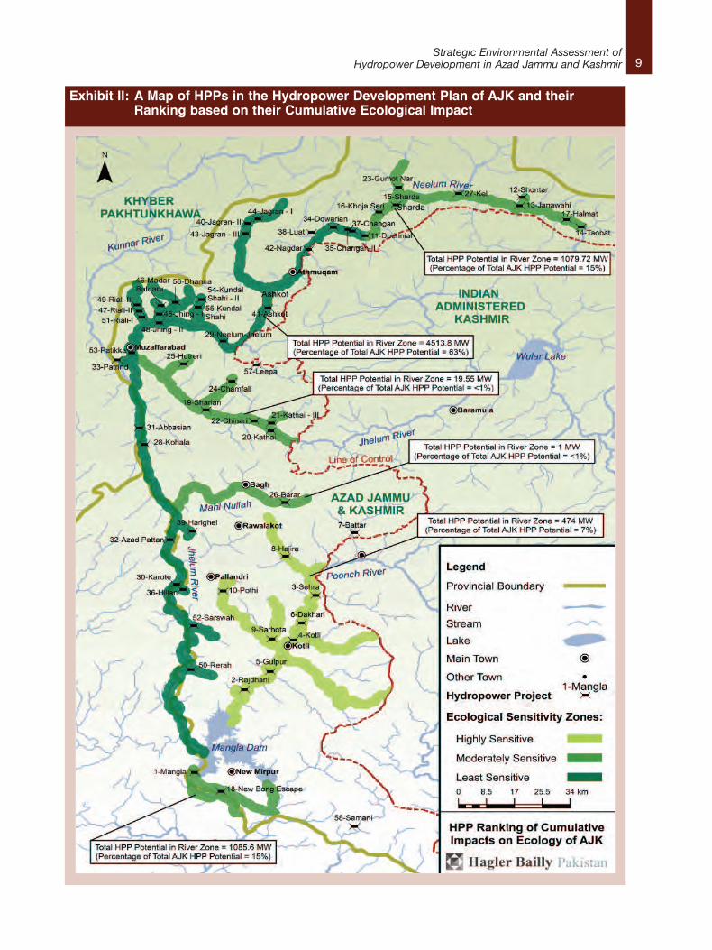
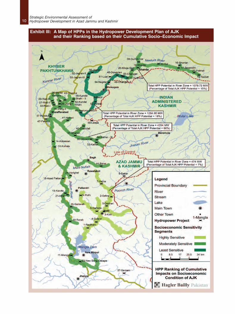
Exhibit II presents the outcome of the cumulativeecological assessment, and Exhibit III presents asimilar analysis, but for socio–economic impacts.A clear outcome is that the area of most concern,both from ecological and socio–economicperspectives, is the Poonch River and its feed–innullahs from the Line of Control down to theMangla Dam. The nine proposed HPPs all rankhighest for potential ecological and social impact.As indicated in Exhibits 2 and 3, however, itshould be noted that the Poonch River segmentonly accounts for 7% of the total AJK hydropowergeneration potential.
9Strategic Environmental Assessment of
Hydropower Development in Azad Jammu and Kashmir
Exhibit II: A Map of HPPs in the Hydropower Development Plan of AJK and their Ranking based on their Cumulative Ecological Impact
10Strategic Environmental Assessment ofHydropower Development in Azad Jammu and Kashmir
Exhibit III: A Map of HPPs in the Hydropower Development Plan of AJKand their Ranking based on their Cumulative Socio–Economic Impact
11Strategic Environmental Assessment of
Hydropower Development in Azad Jammu and Kashmir
Informing Decision–makingThe analyses undertaken during the “establishingthe context” and “cumulative impact assessment”components of the SEA pilot study resulted in anumber of recommendations for institutionalreform that will allow overall hydropower planningfor AJK to be improved. The followingrecommendations focus on: clarifyingresponsibilities for hydropower plan ownership;improving project development planning;guidelines for environmental impact assessment;and, proposing minor regulatory amendments.
Recommendation 1: Establishment of an AJKHydropower Planning CommitteeAn AJK Hydropower Planning Committee shouldbe established. It should be made up of seniormanagers from WAPDA, HEB, PPIB, and PPC,along with other relevant AJK governmentrepresentatives from the wildlife, fisheries, andtourism sectors. The purpose of the Committeeshould be to develop and regularly update anoverall hydropower plan for AJK. Establishmentand management of the Hydropower PlanningCommittee should be the responsibility of the AJKP&DD1.
Recommendation 2: Development of aCoordinated Hydropower Development PlanA comprehensive hydropower plan or basindevelopment plan needs to be developed and“owned” by all four agencies as members of theHydropower Development Organization. This planshould be updated on a regular (perhaps6–monthly) basis.
Recommendation 3: Promoting SynergisticProject DevelopmentWhere there are HPPs in close proximity to eachother, either on a main river, or on tributarynullahs, proponents should be required to consultabout project design to enable synergisticdevelopment. Such consultation should berequired even if project initiation schedules arenot synchronized.
Recommendation 4: Terms of ReferenceTerms of Reference for full EIA studies associatedwith relevant HPPs should include cumulativeassessment requirements.
Recommendation 5: Indicator Species andMonitoringThe AJKEPA should select fish species in differentecological stretches of AJK rivers as indicators ofriver–health. The number of these indicator–fishspecies should be monitored regularly throughoutthe life of the hydropower plan.
Recommendation 6: Ecological FlowKeeping in view the high ecologically sensitivity ofthe Poonch River and its tributaries, it isrecommended that all the hydropower projectsplanned on the Poonch River should use holisticapproaches for determination of downstreamenvironmental flow.
Recommendation 7: Regulatory AmendmentThe 50 MW benchmark should not be the mainscreening criterion used to determine the requiredlevel of environmental assessment. AJK EPAshould use ecological and social sensitivityranking tables and maps to determine whether aHPP should require an IEE or EIA.
The Azad Jammu & Kashmir EnvironmentalProtection Agency Review of Initial EnvironmentalExamination (IEE) and Environmental ImpactAssessment (EIA) Regulations 2009, Schedule Iand Schedule II should be rewritten as follows:Schedule I: List of Projects Requiring an IEE
B. EnergyAdditional sentence to add to point 1:Projects under 50MW qualify for an IEE, unlessthey are located on a “highly sensitive” ecologicaland/or social segment, in which case they mustundergo a full EIA.Schedule II: List of Projects Requiring an EIAA. EnergyNo changes required to this Schedule.
1. At a workshop held in Muzaffarabad on February 14, 2014 to present the results of Phase 3, senior officials indicated that a HydropowerDevelopment Organization had been recently established, and that it absorbed the planning responsibilities of HEB, PPIB, and HEC.
12Strategic Environmental Assessment ofHydropower Development in Azad Jammu and Kashmir
1.1 The Pilot Strategic Environmental Assessment StudyThe Government of Pakistan (GoP) and the International Union forConservation of Nature (IUCN) have jointly implemented the National ImpactAssessment Program (NIAP), which aims to contribute to sustainabledevelopment in Pakistan through strengthening the Environmental ImpactAssessment (EIA) process and introducing Strategic EnvironmentalAssessment (SEA) in national development planning. The Program has fourimplementation partners: Pakistan Environmental Protection Agency (PakEPA),Environment Wing (EW) of the Ministry of Climate Change (MoCC), PlanningCommission of Pakistan (PC), and IUCN Pakistan. Additionally, theNetherlands Commission for Environmental Assessment (NCEA) has anadvisory role in the Project and provides technical advice. The total duration ofthe Program is four and a half years.
To facilitate the SEA activities under NIAP, a SEA Task Force has beenestablished at the Planning Commission to oversee the introduction of SEA inthe country, including supervision of SEA pilot studies. In its second and thirdmeetings, the Task Force decided that SEA pilots would be selected from theurban land–use planning and energy sectors, with the latter having a specificfocus on power generation. As a result of the discussions held in the State ofAzad Jammu and Kashmir (AJK), the Government of AJK agreed to volunteerits hydropower plan (the ‘Plan’) for SEA piloting.
The objectives of the pilot SEA of the hydropower plan were to:l develop an understanding of the state of hydropower planning in AJK;
l assess the potential environmental and social risks associated with thehydropower plan;
l assess the potential environmental and social benefits associated with thehydropower plan;
l if necessary, suggest alternative plan options that better optimizeeconomic, environmental, and social outcomes; and,
1. Introduction
l assess the institutional and policy constraintsto mainstreaming environmental and socialconsiderations into AJK hydropower planningand development, and providerecommendations on how these constrainsmight be addressed.
1.2 Outline of the Development of the SEA PilotStudyThe SEA pilot study was undertaken in threephases, over a 12–month period from February2012, to February 2013. The first phase beganwith a 3–day preparatory training workshop inMuzaffarabad for approximately 80 participants,followed by a second mixed training andvalidation workshop in Mirpur in April, 2013.
The output report from the first phase helped toestablish the context behind the Plan byidentifying its objectives; investigating theorganizational responsibility for the overall Plan;and, conducting an institutional and stakeholderanalysis to ascertain the relationship between thePlan and the plans and strategies of other publicand private sectors in AJK. It also detailedrelevant government policies and mappedhydropower projects (HPPs) in different stages ofdevelopment, illustrating their locations, installedpower generating capacities, and the governmentinstitutions in charge of their development. Phase1 work was presented in a report titled“Establishing the Context”, and dated June 17th,2013.
The objective of Phase 2 was to assist the AJKauthorities to identify the scale, diversity,magnitude and complexity of the potentialenvironmental and social impacts emanating fromthe development of the Plan, and to identify theareas and river sections most sensitive to thoseimpacts. This component was the mosttechnically–complex part of the SEA study, andwas published in a report titled, “CumulativeImpacts of Hydropower Projects”, and datedNovember 20, 2013.
The objective of Phase 3 of the SEA pilot was topresent recommendations for institutional reformthat would allow the majority of recommendationsmade in Phase 2 to be implemented, and overallhydropower planning for AJK to be improved. Thefocus of Phase 3 was on: clarifyingresponsibilities for hydropower plan ownership;improving project development planning;guidelines for environmental impact assessment;and, proposing minor regulatory amendments.The work undertaken in Phase 3 was publishedon January 28th, 2014 in a report titled,“Informing Decision–making”.
1.3 Outline of the Final ReportThis final report brings together all of thebackground, analysis, and recommendationsmade in the three phases of the SEA pilot study.Section 2 establishes the context for the SEAstudy by focusing on the hydropower plan, itsobjectives, and the institutions and stakeholdersthat have an interest in hydropower development.Section 3 presents the results from Phase 2 of thepilot. It focuses entirely on examining thecumulative impacts of the projects proposed inthe short–and–medium term. Section 4 concludeswith recommendations that relate to informingfuture decision–making.
13Strategic Environmental Assessment of
Hydropower Development in Azad Jammu and Kashmir
14Strategic Environmental Assessment ofHydropower Development in Azad Jammu and Kashmir
2.1 IntroductionThis section of the final report establishes the context behind the Governmentof AJK’s hydropower development plan, by identifying its objectives;investigating the organizational responsibility for the overall plan; andconducting an institutional and stakeholder analysis to ascertain therelationship between the plan, and the strategies and plans of other public andprivate proponents in AJK.
2.2 Mapping Hydropower Development in AJKOver the last decade, the development of hydropower resources in AJK hasbecome a priority for the government as a result of Pakistan’s significantshortfall in energy production, which is estimated to rise to over 8,500 MW.2
This shortfall has resulted in prolonged power cuts and is adversely affectedeconomic growth and development, thereby becoming one of the topchallenges facing the political leadership of the country.
AJK’s hydropower development would be a significant contribution toPakistan’s energy demands as electricity produced by power plants in theformer – and in the four Pakistani provinces – is sold to the latter’s NationalTransmission and Distribution Company (NTDC) which redistributes it acrossPakistan and AJK through the national grid.
Given the challenge of meeting the energy demands of the country, while alsokeeping energy costs affordable for consumers, the Government of Pakistan(GoP) has prioritized hydropower development across all territories in itscontrol. AJK, with its estimated hydropower potential of over 5,000 MW,figures significantly in this plan. The AJK government is committed tofast–tracking hydropower projects to raise the installed hydropower capacityfrom its current levels, of approximately 120 MW to 400 MW by the year 2015.3
The road map for achieving this goal is a result of the combined effect ofPakistan’s Policy for Power Generation 2002 and WAPDA’s Vision 2025 –Hydro Development Plan.
2. Phase 1: Establishing the Context
2. Dawn. (2012, June 17). Electricity Shortfall in the Country Reaches 8,500 MW. Retrieved May 2013, 20,from Pakistan: http://dawn.com/2012/06/17/residents–protest–prolonged–loadshedding–in–lahore
3. Hydro Electric Board. (n.d.). Objectives. Retrieved May 18, 2013, from AJK Hydro Electric Board:http://www.ajkheb.org/ObjectivesPolicies
15Strategic Environmental Assessment of
Hydropower Development in Azad Jammu and Kashmir
2.2.1 Policy for Power Generation Projects2002 Hydropower development in the State of AJK isgoverned in the main by the Policy for PowerGeneration Projects (2002) formulated byPakistan’s Ministry of Water and Power (MW&P).With a view to addressing projected powershortages, the policy includes several“investor–friendly” changes in the methodologyand approach to implementing new powerprojects across the country. It provided a clear setof incentives, along with a regulatory regime thateffectively gives a roadmap to attract privateinvestment in power generation at competitiveprices.4
Through the power generation policy of 2002, theGoP promotes solicited bids for hydropowerprojects and indigenous fuel–based projectswhere feasibility studies are already available or,where feasibility study work is to be initiated onraw–sites for exploiting indigenous as well asrenewable resources.5
Salient Features of Power Policy 2002The salient features of the Power Policy of 2002are as follows:6
l The scope of the policy covers private,public-private and public sector projects.
l Aims to enhance share of renewable energyresources especially hydropower.
l Encourages exploration of indigenousresources including hydel, coal gas andrenewable resources through activeinvolvement of local engineering, design andmanufacturing capabilities.
l Includes invitation of bids on tariff throughinternational competitive bidding (ICB);
l Encourages unsolicited bids to develop rawsites where feasibility studies are not available.
l Projects above 50 MW are to be handled atthe federal level while projects below 50MWare to be supported, facilitated and handledby the respective provincial and AJKdepartments they are geographically locatedin.
l MW&P, through the Private Power andInfrastructure Board (PPIB) remains the focalpoint at federal level.
The 2002 power policy has been adopted by theGoAJK, providing guidelines for private sectorinvestment in the development of hydropowerprojects in the state. The policy was formulated topromote private investment and public–privatepartnerships across Pakistan and the State ofAJK allowing the provinces and AJK to manageinvestments for power projects up to 50 MW whilethose above 50 MW would be handled at thefederal level.
Salient Features of the 2002 Power Policy asAdopted by the GoAJKThe salient features of the 2002 power policy asadopted by the GoAJK are as follows:7v
l Raw sites are to be awarded onfirst–come–first–serve basis to interestedinvestors who establish their financialsoundness in meeting the equity componentof the investment.
l Sites where feasibility studies have alreadybeen conducted can be made part ofsolicited competitive bidding if the interestedinvestors reimburse the cost of the feasibilitystudy.
l State–owned land would be leased onconcessional rates for project development toinvestors and developers without provisionfor escalation of lease rates.
4. Government of Khyber Pukhtunkhawa. (2006). Policy for Hydropower Generation Projects . Peshawar, KPK.5. In the context of hydropower development, Pakistan’s Water and Power Development Authority (WAPDA) and respective hydropower
development departments of the provinces and states within Pakistan, including AJK, conduct topographical and hydrological studies oflocations with a potential for further developed as a hydropower site. After preliminary tests, such sites are designated ‘raw–sites’, if they aredeemed fit for a full and detailed feasibility study for development into a hydropower project
6. Pakistan Water and Power Development Authority. (2012). Hydro Potential in Pakistan. WAPDA House, Lahore – Pakistan: Public RelationsDivision (WAPDA).
7. Hydro Electric Board. (n.d.). Objectives. Retrieved May 18, 2013, from AJK Hydro Electric Board: http://www.ajkheb.org/ObjectivesPolicies
16Strategic Environmental Assessment ofHydropower Development in Azad Jammu and Kashmir
l Support is to be provided for acquisition,leasing and purchase of privately owned landthrough the relevant land revenuedepartment.
l Support is also provided for setting up ofregional Receipt and Dispatch grid foroptimal utilization of capacity.
l A generous package forBuild–Operate–Transfer (BOT) implementationincluding 5 years grace period for extensionof operation is available.
l Generous tax/levies and incentives areincluded to promote cottage industrial andagricultural units running on hydropowerprojects on the concept of captivegeneration.
2.2.2 WAPDA’s Vision 2025 Hydro DevelopmentPlanIn 2008, Pakistan’s Water and PowerDevelopment Authority (WAPDA) announced itsVision 2025–National Water Resource andHydropower Development Program designed toorganize and prioritize the development ofhydropower projects in the short, medium andlong term to meet the power deficits facing thecountry.8 It is revised and updated according toWAPDA’s annual report submitted to the GoP, anddetails the current and future development ofhydropower resources across Pakistan and AJK.
Vision 2025 details all of the hydropowerdevelopment related activities in Pakistan andAJK being undertaken along with their status andprogress. Identified projects are designated, eitherto the public or private sector, or to apublic–private partnership for construction andcommissioning depending upon the urgency tocomplete a project while keeping in view the
resources available from the government orprivate funders.9 The Water and PowerDevelopment Authority (WAPDA) is carrying outfeasibility studies and engineering designs forvarious hydropower projects with a cumulativegeneration capacity of more than 25,000 MW,with a view to increasing the installed hydropowercapacity across Pakistan to around 42,000 MWby the end of the year 2020.10
Taking into account the objectives of the powergeneration policy of 2008 and the lack of availablefunds in the national exchequer, WAPDA’s Vision2025 is heavily oriented towards the privatesector for the development of the differentprojects. The projects compiled in the programare categorized in one of the following forms:l Raw–sites for hydropower projects identified
and ready for feasibility studies by the privatesector;11
l Hydropower sites complete with feasibilitystudies conducted by the private or publicsector, ready to be developed further by theprivate sector or under Public PrivatePartnerships (PPP) and;
l Private hydropower projects undertaken byprovincial governments, Gilgit Baltistan andAJ&K, where the power purchaser is thefederal entity; where the transmission ordistribution network of the federalgovernment is used; and where the tariffdetermined or approved by National ElectricPower Regulatory Authority (NEPRA) or GoPguarantee is required.
2.3 Proposed Hydropower Projects in AJKAccording to the latest information available fromall the government agencies involved inhydropower development in AJK, there arecurrently 12 operational hydropower projects inthe state. An additional 13 are under construction
8. Siddiqui, R. H. (2008, September 24). Wapda 'Vision 2025' to help solve power crisis. Retrieved May 24, 2013, from The Nation:http://www.nation.com.pk/pakistan–news–newspaper–daily–english–online/Business/24–Sep–2008/Wapda–Vision–2025–to–help–solve–power–crisis.
9. Pakistan Water and Power Development Authority. (2011). Annual Report 2010 – 2011. WAPDA House, Lahore – Pakistan: Public RelationsDivision (WAPDA).
10. Pakistan Water and Power Development Authority. (2012). Hydro Potential in Pakistan. WAPDA House, Lahore – Pakistan: Public RelationsDivision (WAPDA).
11. Raw sites are those identified by WAPDA as potentially suited for hydropower development due to suitable hydrology and topography. Rawsites undergo feasibility studies after which hydropower development on the site commences.
17Strategic Environmental Assessment of
Hydropower Development in Azad Jammu and Kashmir
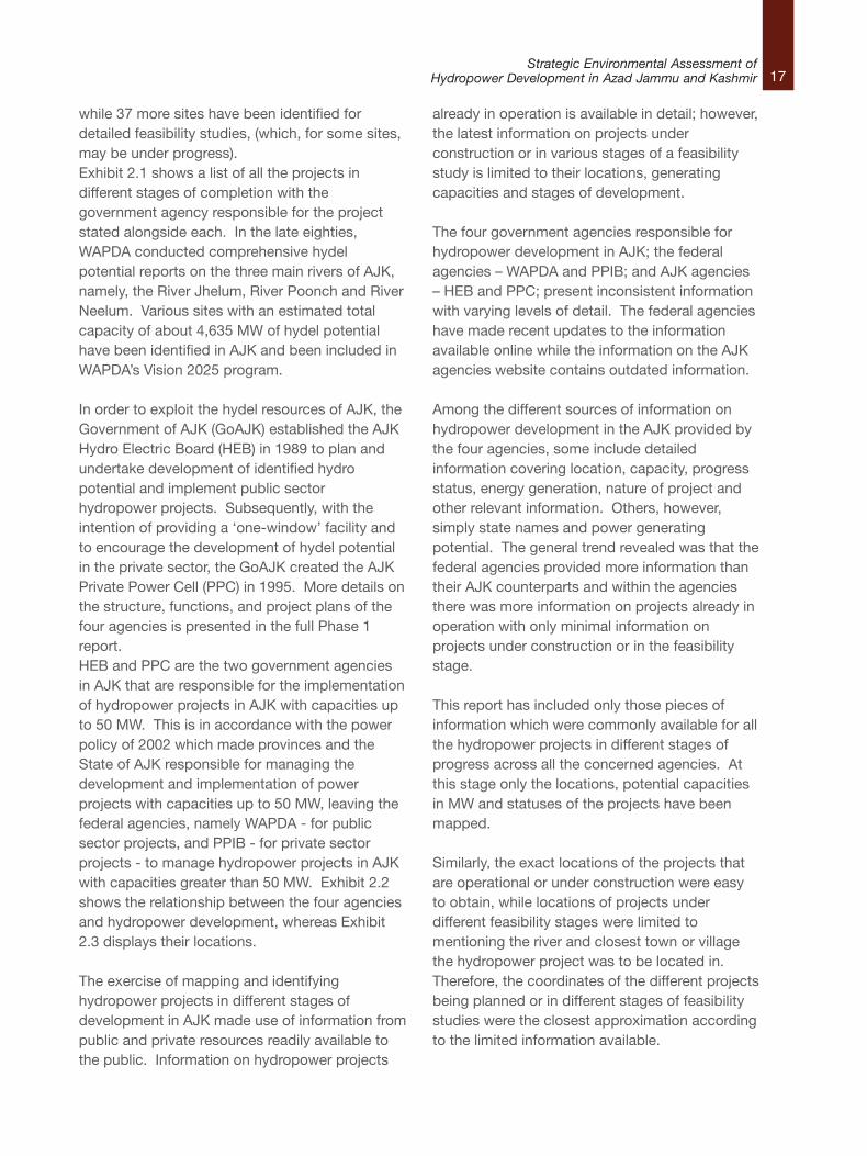
while 37 more sites have been identified fordetailed feasibility studies, (which, for some sites,may be under progress).Exhibit 2.1 shows a list of all the projects indifferent stages of completion with thegovernment agency responsible for the projectstated alongside each. In the late eighties,WAPDA conducted comprehensive hydelpotential reports on the three main rivers of AJK,namely, the River Jhelum, River Poonch and RiverNeelum. Various sites with an estimated totalcapacity of about 4,635 MW of hydel potentialhave been identified in AJK and been included inWAPDA’s Vision 2025 program.
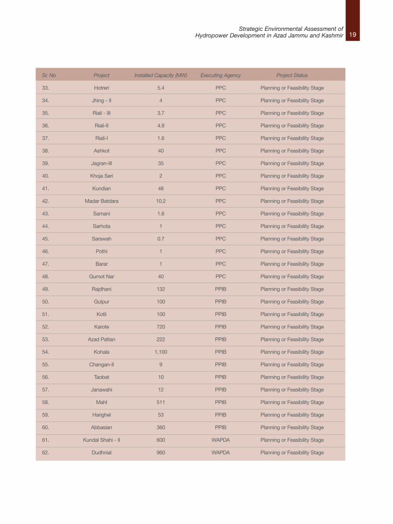
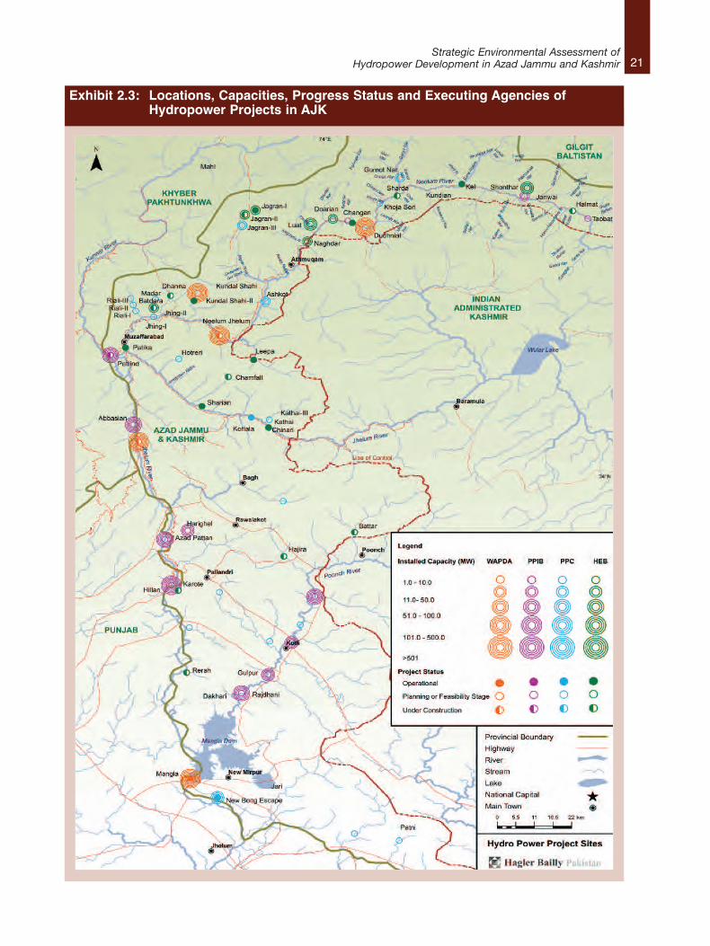
In order to exploit the hydel resources of AJK, theGovernment of AJK (GoAJK) established the AJKHydro Electric Board (HEB) in 1989 to plan andundertake development of identified hydropotential and implement public sectorhydropower projects. Subsequently, with theintention of providing a ‘one-window’ facility andto encourage the development of hydel potentialin the private sector, the GoAJK created the AJKPrivate Power Cell (PPC) in 1995. More details onthe structure, functions, and project plans of thefour agencies is presented in the full Phase 1report.HEB and PPC are the two government agenciesin AJK that are responsible for the implementationof hydropower projects in AJK with capacities upto 50 MW. This is in accordance with the powerpolicy of 2002 which made provinces and theState of AJK responsible for managing thedevelopment and implementation of powerprojects with capacities up to 50 MW, leaving thefederal agencies, namely WAPDA - for publicsector projects, and PPIB - for private sectorprojects - to manage hydropower projects in AJKwith capacities greater than 50 MW. Exhibit 2.2shows the relationship between the four agenciesand hydropower development, whereas Exhibit2.3 displays their locations.
The exercise of mapping and identifyinghydropower projects in different stages ofdevelopment in AJK made use of information frompublic and private resources readily available tothe public. Information on hydropower projects
already in operation is available in detail; however,the latest information on projects underconstruction or in various stages of a feasibilitystudy is limited to their locations, generatingcapacities and stages of development.
The four government agencies responsible forhydropower development in AJK; the federalagencies – WAPDA and PPIB; and AJK agencies– HEB and PPC; present inconsistent informationwith varying levels of detail. The federal agencieshave made recent updates to the informationavailable online while the information on the AJKagencies website contains outdated information.
Among the different sources of information onhydropower development in the AJK provided bythe four agencies, some include detailedinformation covering location, capacity, progressstatus, energy generation, nature of project andother relevant information. Others, however,simply state names and power generatingpotential. The general trend revealed was that thefederal agencies provided more information thantheir AJK counterparts and within the agenciesthere was more information on projects already inoperation with only minimal information onprojects under construction or in the feasibilitystage.
This report has included only those pieces ofinformation which were commonly available for allthe hydropower projects in different stages ofprogress across all the concerned agencies. Atthis stage only the locations, potential capacitiesin MW and statuses of the projects have beenmapped.
Similarly, the exact locations of the projects thatare operational or under construction were easyto obtain, while locations of projects underdifferent feasibility stages were limited tomentioning the river and closest town or villagethe hydropower project was to be located in.Therefore, the coordinates of the different projectsbeing planned or in different stages of feasibilitystudies were the closest approximation accordingto the limited information available.
18Strategic Environmental Assessment ofHydropower Development in Azad Jammu and Kashmir
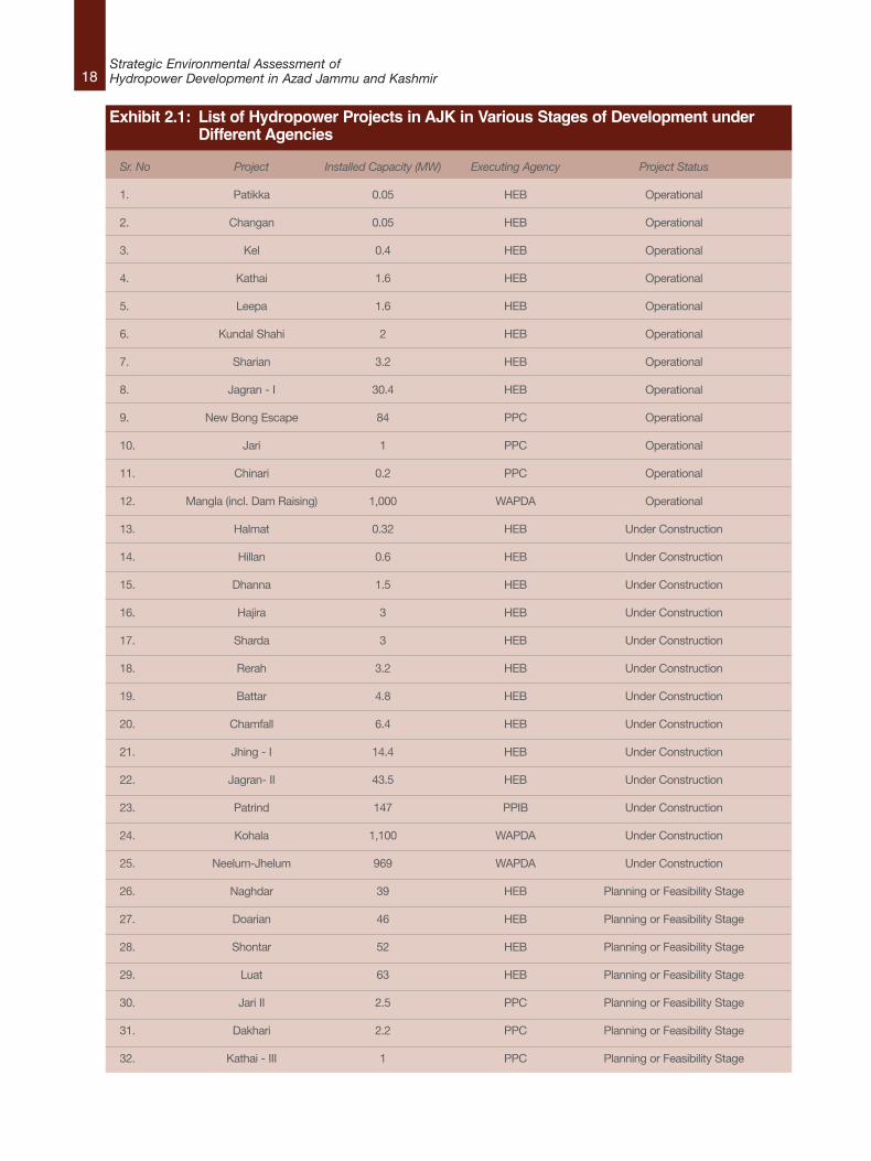
Exhibit 2.1: List of Hydropower Projects in AJK in Various Stages of Development under Different Agencies
Sr. No Project Installed Capacity (MW) Executing Agency Project Status
1. Patikka 0.05 HEB Operational
2. Changan 0.05 HEB Operational
3. Kel 0.4 HEB Operational
4. Kathai 1.6 HEB Operational
5. Leepa 1.6 HEB Operational
6. Kundal Shahi 2 HEB Operational
7. Sharian 3.2 HEB Operational
8. Jagran - I 30.4 HEB Operational
9. New Bong Escape 84 PPC Operational
10. Jari 1 PPC Operational
11. Chinari 0.2 PPC Operational
12. Mangla (incl. Dam Raising) 1,000 WAPDA Operational
13. Halmat 0.32 HEB Under Construction
14. Hillan 0.6 HEB Under Construction
15. Dhanna 1.5 HEB Under Construction
16. Hajira 3 HEB Under Construction
17. Sharda 3 HEB Under Construction
18. Rerah 3.2 HEB Under Construction
19. Battar 4.8 HEB Under Construction
20. Chamfall 6.4 HEB Under Construction
21. Jhing - I 14.4 HEB Under Construction
22. Jagran- II 43.5 HEB Under Construction
23. Patrind 147 PPIB Under Construction
24. Kohala 1,100 WAPDA Under Construction
25. Neelum-Jhelum 969 WAPDA Under Construction
26. Naghdar 39 HEB Planning or Feasibility Stage
27. Doarian 46 HEB Planning or Feasibility Stage
28. Shontar 52 HEB Planning or Feasibility Stage
29. Luat 63 HEB Planning or Feasibility Stage
30. Jari II 2.5 PPC Planning or Feasibility Stage
31. Dakhari 2.2 PPC Planning or Feasibility Stage
32. Kathai - III 1 PPC Planning or Feasibility Stage
19Strategic Environmental Assessment of
Hydropower Development in Azad Jammu and Kashmir
Sr. No Project Installed Capacity (MW) Executing Agency Project Status
33. Hotreri 5.4 PPC Planning or Feasibility Stage
34. Jhing - II 4 PPC Planning or Feasibility Stage
35. Riali - III 3.7 PPC Planning or Feasibility Stage
36. Riali-II 4.9 PPC Planning or Feasibility Stage
37. Riali-I 1.6 PPC Planning or Feasibility Stage
38. Ashkot 40 PPC Planning or Feasibility Stage
39. Jagran-III 35 PPC Planning or Feasibility Stage
40. Khoja Seri 2 PPC Planning or Feasibility Stage
41. Kundian 48 PPC Planning or Feasibility Stage
42. Madar Batdara 10.2 PPC Planning or Feasibility Stage
43. Samani 1.6 PPC Planning or Feasibility Stage
44. Sarhota 1 PPC Planning or Feasibility Stage
45. Sarswah 0.7 PPC Planning or Feasibility Stage
46. Pothi 1 PPC Planning or Feasibility Stage
47. Barar 1 PPC Planning or Feasibility Stage
48. Gumot Nar 40 PPC Planning or Feasibility Stage
49. Rajdhani 132 PPIB Planning or Feasibility Stage
50. Gulpur 100 PPIB Planning or Feasibility Stage
51. Kotli 100 PPIB Planning or Feasibility Stage
52. Karote 720 PPIB Planning or Feasibility Stage
53. Azad Pattan 222 PPIB Planning or Feasibility Stage
54. Kohala 1,100 PPIB Planning or Feasibility Stage
55. Changan-II 9 PPIB Planning or Feasibility Stage
56. Taobat 10 PPIB Planning or Feasibility Stage
57. Janawahi 12 PPIB Planning or Feasibility Stage
58. Mahl 511 PPIB Planning or Feasibility Stage
59. Harighel 53 PPIB Planning or Feasibility Stage
60. Abbasian 360 PPIB Planning or Feasibility Stage
61. Kundal Shahi - II 600 WAPDA Planning or Feasibility Stage
62. Dudhnial 960 WAPDA Planning or Feasibility Stage
20Strategic Environmental Assessment ofHydropower Development in Azad Jammu and Kashmir
Exh
ibit 2.2: Institutional Relationsh
ips between W
APDA, P
PIB, H
EB and PPC for Hyd
ropower Dev
elopmen
t in AJK
Hyd
ro Power Projects
in AJK
Cap
acity > 50MW
Priva
te Sector
Public Sector
Cap
acity > 50MW
Private Sec
tor
Public Sector
PPIB
WAPDA
PPC
HEB
21Strategic Environmental Assessment of
Hydropower Development in Azad Jammu and Kashmir
Exhibit 2.3: Locations, Capacities, Progress Status and Executing Agencies of Hydropower Projects in AJK
22Strategic Environmental Assessment ofHydropower Development in Azad Jammu and Kashmir
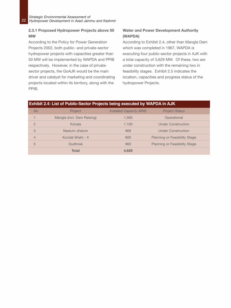
2.3.1 Proposed Hydropower Projects above 50
MW
According to the Policy for Power Generation
Projects 2002, both public- and private-sector
hydropower projects with capacities greater than
50 MW will be implemented by WAPDA and PPIB
respectively. However, in the case of private-
sector projects, the GoAJK would be the main
driver and catalyst for marketing and coordinating
projects located within its territory, along with the
PPIB.
Water and Power Development Authority
(WAPDA)
According to Exhibit 2.4, other than Mangla Dam
which was completed in 1967, WAPDA is
executing four public-sector projects in AJK with
a total capacity of 3,629 MW. Of these, two are
under construction with the remaining two in
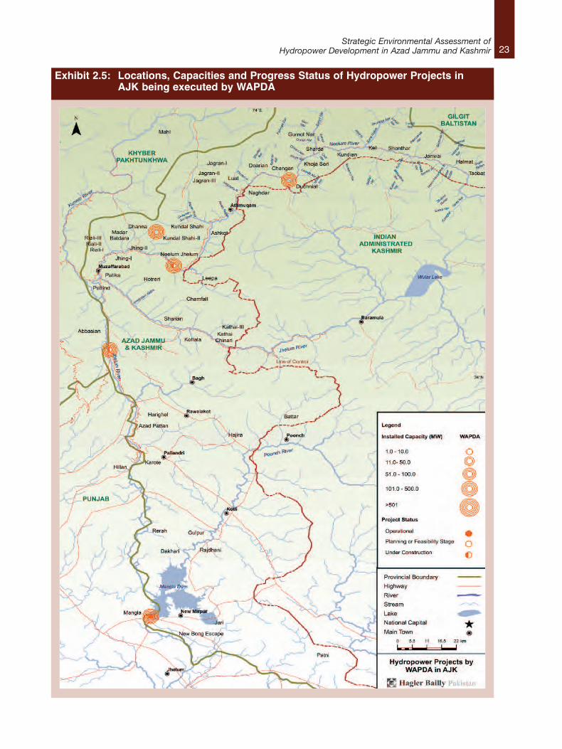
feasibility stages. Exhibit 2.5 indicates the
location, capacities and progress status of the
hydropower Projects.
Exhibit 2.4: List of Public-Sector Projects being executed by WAPDA in AJK
No Project Installed Capacity (MW) Project Status
1 Mangla (incl. Dam Raising) 1,000 Operational
2 Kohala 1,100 Under Construction
3 Neelum-Jhelum 969 Under Construction
4 Kundal Shahi - II 600 Planning or Feasibility Stage
5 Dudhnial 960 Planning or Feasibility Stage
Total 4,629
23Strategic Environmental Assessment of
Hydropower Development in Azad Jammu and Kashmir
Exhibit 2.5: Locations, Capacities and Progress Status of Hydropower Projects in AJK being executed by WAPDA
24Strategic Environmental Assessment ofHydropower Development in Azad Jammu and Kashmir
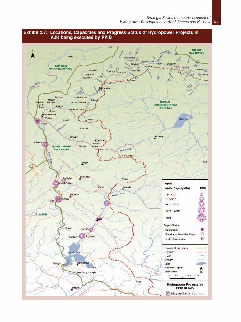
Private Power and Infrastructure Board (PPIB)
According to Exhibit 2.6 the PPIB is in the
process of implementing 13 projects in AJK,
which in total will add 3,476 MW of hydropower in
the state. Out of these, one project is under
construction while the rest are all either ready for
feasibility studies or their feasibility studies are
already in progress. Exhibit 2.7 indicates the
location, capacities and progress status of the
hydropower projects.
Although having capacities below 50 MW, the
feasibility studies for Changan-II, Taobat and
Janawahi will be completed under PPIB, after
which overseeing of the further processing of the
site will come under PPC.
Exhibit 2.6: List of Private-Sector Projects being executed by PPIB in AJK
No Project Installed Capacity (MW) Project Status
1 Patrind 147 Under Construction
2 Rajdhani 132 Planning or Feasibility Stage
3 Gulpur 100 Planning or Feasibility Stage
4 Kotli Hydropower Project 100 Planning or Feasibility Stage
5 Karote 720 Planning or Feasibility Stage
6 Azad Pattan 222 Planning or Feasibility Stage
7 Kohala 1,100 Planning or Feasibility Stage
8 Changan-II 9 Planning or Feasibility Stage
9 Taobat 10 Planning or Feasibility Stage
10 Janawahi 12 Planning or Feasibility Stage
11 Mahl 511 Planning or Feasibility Stage
12 Harighel 53 Planning or Feasibility Stage
13 Abbasian 360 Planning or Feasibility Stage
Total 3,476
25Strategic Environmental Assessment of
Hydropower Development in Azad Jammu and Kashmir
Exhibit 2.7: Locations, Capacities and Progress Status of Hydropower Projects inAJK being executed by PPIB
26Strategic Environmental Assessment ofHydropower Development in Azad Jammu and Kashmir
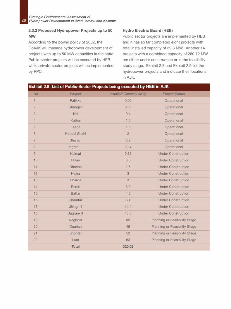
2.3.2 Proposed Hydropower Projects up to 50
MW
According to the power policy of 2002, the
GoAJK will manage hydropower development of
projects with up to 50 MW capacities in the state.
Public-sector projects will be executed by HEB
while private-sector projects will be implemented
by PPC.
Hydro Electric Board (HEB)
Public sector projects are implemented by HEB
and it has so far completed eight projects with
total installed capacity of 39.3 MW. Another 14
projects with a combined capacity of 280.72 MW
are either under construction or in the feasibility-
study stage. Exhibit 2.8 and Exhibit 2.9 list the
hydropower projects and indicate their locations
in AJK.
Exhibit 2.8: List of Public-Sector Projects being executed by HEB in AJK
No Project Installed Capacity (MW) Project Status
1 Patikka 0.05 Operational
2 Changan 0.05 Operational
3 Kel 0.4 Operational
4 Kathai 1.6 Operational
5 Leepa 1.6 Operational
6 Kundal Shahi 2 Operational
7 Sharian 3.2 Operational
8 Jagran – I 30.4 Operational
9 Halmat 0.32 Under Construction
10 Hillan 0.6 Under Construction
11 Dhanna 1.5 Under Construction
12 Hajira 3 Under Construction
13 Sharda 3 Under Construction
14 Rerah 3.2 Under Construction
15 Battar 4.8 Under Construction
16 Chamfall 6.4 Under Construction
17 Jhing - I 14.4 Under Construction
18 Jagran- II 43.5 Under Construction
19 Naghdar 39 Planning or Feasibility Stage
20 Doarian 46 Planning or Feasibility Stage
21 Shontar 52 Planning or Feasibility Stage
22 Luat 63 Planning or Feasibility Stage
Total 320.02

27Strategic Environmental Assessment of
Hydropower Development in Azad Jammu and Kashmir
Exhibit 2.9: Locations, Capacities and Progress Status of Hydropower Projects in AJK being executed by HEB
28Strategic Environmental Assessment ofHydropower Development in Azad Jammu and Kashmir
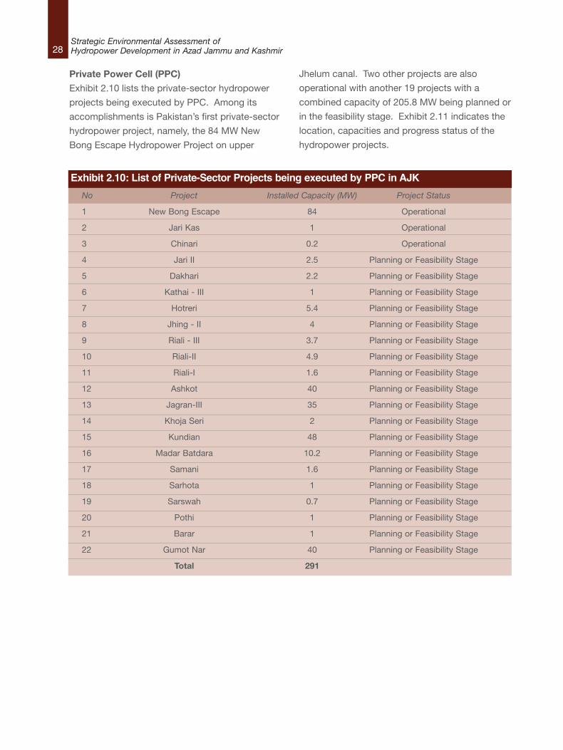
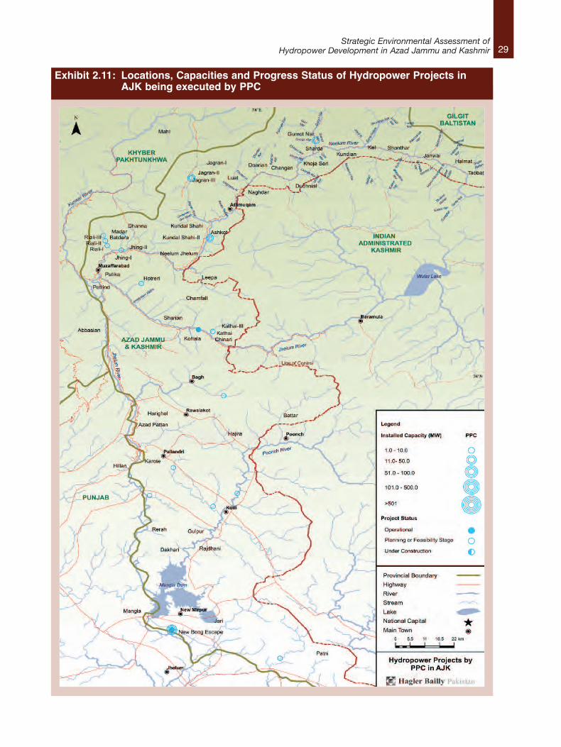
Private Power Cell (PPC)
Exhibit 2.10 lists the private-sector hydropower
projects being executed by PPC. Among its
accomplishments is Pakistan’s first private-sector
hydropower project, namely, the 84 MW New
Bong Escape Hydropower Project on upper
Jhelum canal. Two other projects are also
operational with another 19 projects with a
combined capacity of 205.8 MW being planned or
in the feasibility stage. Exhibit 2.11 indicates the
location, capacities and progress status of the
hydropower projects.
Exhibit 2.10: List of Private-Sector Projects being executed by PPC in AJK
No Project Installed Capacity (MW) Project Status
1 New Bong Escape 84 Operational
2 Jari Kas 1 Operational
3 Chinari 0.2 Operational
4 Jari II 2.5 Planning or Feasibility Stage
5 Dakhari 2.2 Planning or Feasibility Stage
6 Kathai - III 1 Planning or Feasibility Stage
7 Hotreri 5.4 Planning or Feasibility Stage
8 Jhing - II 4 Planning or Feasibility Stage
9 Riali - III 3.7 Planning or Feasibility Stage
10 Riali-II 4.9 Planning or Feasibility Stage
11 Riali-I 1.6 Planning or Feasibility Stage
12 Ashkot 40 Planning or Feasibility Stage
13 Jagran-III 35 Planning or Feasibility Stage
14 Khoja Seri 2 Planning or Feasibility Stage
15 Kundian 48 Planning or Feasibility Stage
16 Madar Batdara 10.2 Planning or Feasibility Stage
17 Samani 1.6 Planning or Feasibility Stage
18 Sarhota 1 Planning or Feasibility Stage
19 Sarswah 0.7 Planning or Feasibility Stage
20 Pothi 1 Planning or Feasibility Stage
21 Barar 1 Planning or Feasibility Stage
22 Gumot Nar 40 Planning or Feasibility Stage
Total 291
29Strategic Environmental Assessment of
Hydropower Development in Azad Jammu and Kashmir
Exhibit 2.11: Locations, Capacities and Progress Status of Hydropower Projects in AJK being executed by PPC
30Strategic Environmental Assessment ofHydropower Development in Azad Jammu and Kashmir
2.4 The Hydropower Plan and the Focus of the SEA The focus of this SEA is the hydropowerdevelopment plan for AJK. Initial consultationswith Government agencies led to the conclusionthat no overall, coordinating strategic plan exists.The closest approximation to such a plan is thecollection of individual project proposals ofWAPDA, the PPIB, the HEB, and the PPC thatwere listed and described in Section 2.3. For thepurposes of this pilot SEA, this combinedcollection of proposals is taken to be “the plan”.
As is generally understood, SEA can take one oftwo forms. It can be applied to a policy, plan, orprogramme (PPP), after the initiative in questionhas already been designed or even undertaken.This form of SEA is known as “ex post” or “afterthe fact”. When SEA is applied in this fashion, it isakin to the approach taken by environmentalimpact assessment (EIA), when it is applied tosite–specific development projects. In its otherconception, SEA can be applied as a method forincorporating environmental concerns or issuesinto the development of a PPP. In this “ex ante” or“before the fact” form, SEA influences the actualdesign of a PPP before it is completed andexecuted.
In this case study, the SEA took the form of an expost assessment based on the collection of 62existing or proposed projects that were listed inExhibit 2.1.
2.5 The Hydropower Plan and the Focus ofthe SEA The focus of this SEA is the hydropowerdevelopment plan for AJK. Initial consultationswith Government agencies led to the conclusionthat no overall, coordinating strategic plan exists.The closest approximation to such a plan is thecollection of individual project proposals ofWAPDA, the PPIB, the HEB, and the PPC thatwere listed and described in Section 2.3. For thepurposes of this pilot SEA, this combinedcollection of proposals is taken to be “the plan”.
As is generally understood, SEA can take one oftwo forms. It can be applied to a policy, plan, or
programme (PPP), after the initiative in questionhas already been designed or even undertaken.This form of SEA is known as “ex post” or “afterthe fact”. When SEA is applied in this fashion, it isakin to the approach taken by environmentalimpact assessment (EIA), when it is applied tosite–specific development projects. In its otherconception, SEA can be applied as a method forincorporating environmental concerns or issuesinto the development of a PPP. In this “ex ante” or“before the fact” form, SEA influences the actualdesign of a PPP before it is completed andexecuted.
In this case study, the SEA took the form of an expost assessment based on the collection of 62existing or proposed projects that were listed inExhibit 2.1.
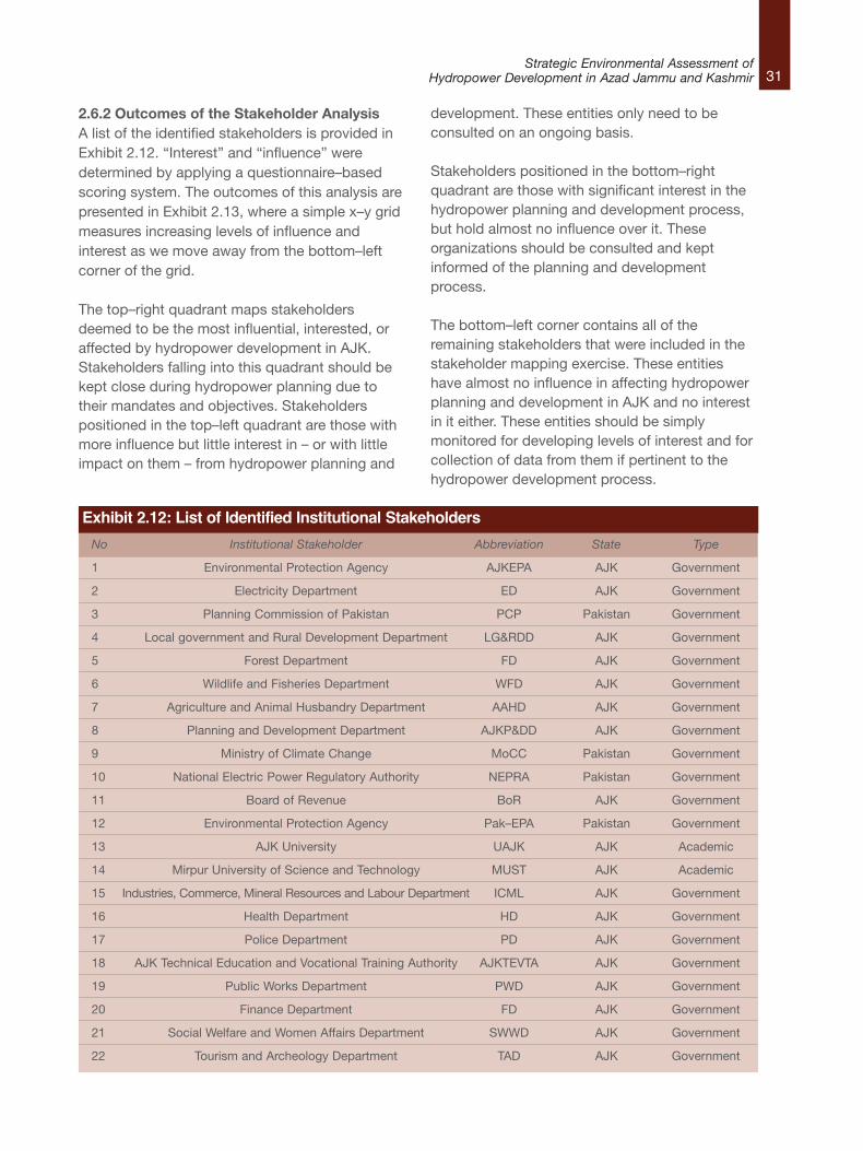
2.6 Stakeholder Identification and Mapping Section 2.3 provided an understanding of theintensity of proposed hydropower development inAJK. Building 62 dams in a relatively small areawill likely affect the interests and livelihoods ofmany stakeholders. Phase 1 of the SEAundertook a detailed stakeholder analysis. Theoutcomes of that work are presented in full in thePhase 1 report.
2.6.1 Stakeholder Analysis MethodologyThe following methodology was adopted foridentification and analysis of potentialstakeholders in hydropower development in AJK:l A web–based search was conducted to
identify all the government departments,NGOs and civil society organizations thatwere considered relevant to hydropowerdevelopment in AJK.
l A matrix was developed to measure the levelof interest and influence of the stakeholdersin hydropower planning and development inAJK, with the help of information available onthe websites of these institutions.
l The scores from stakeholder influence andinterest analyses were mapped.
31Strategic Environmental Assessment of
Hydropower Development in Azad Jammu and Kashmir
2.6.2 Outcomes of the Stakeholder AnalysisA list of the identified stakeholders is provided inExhibit 2.12. “Interest” and “influence” weredetermined by applying a questionnaire–basedscoring system. The outcomes of this analysis arepresented in Exhibit 2.13, where a simple x–y gridmeasures increasing levels of influence andinterest as we move away from the bottom–leftcorner of the grid.
The top–right quadrant maps stakeholdersdeemed to be the most influential, interested, oraffected by hydropower development in AJK.Stakeholders falling into this quadrant should bekept close during hydropower planning due totheir mandates and objectives. Stakeholderspositioned in the top–left quadrant are those withmore influence but little interest in – or with littleimpact on them – from hydropower planning and
development. These entities only need to beconsulted on an ongoing basis.
Stakeholders positioned in the bottom–rightquadrant are those with significant interest in thehydropower planning and development process,but hold almost no influence over it. Theseorganizations should be consulted and keptinformed of the planning and developmentprocess.
The bottom–left corner contains all of theremaining stakeholders that were included in thestakeholder mapping exercise. These entitieshave almost no influence in affecting hydropowerplanning and development in AJK and no interestin it either. These entities should be simplymonitored for developing levels of interest and forcollection of data from them if pertinent to thehydropower development process.
Exhibit 2.12: List of Identified Institutional Stakeholders
No Institutional Stakeholder Abbreviation State Type
1 Environmental Protection Agency AJKEPA AJK Government
2 Electricity Department ED AJK Government
3 Planning Commission of Pakistan PCP Pakistan Government
4 Local government and Rural Development Department LG&RDD AJK Government
5 Forest Department FD AJK Government
6 Wildlife and Fisheries Department WFD AJK Government
7 Agriculture and Animal Husbandry Department AAHD AJK Government
8 Planning and Development Department AJKP&DD AJK Government
9 Ministry of Climate Change MoCC Pakistan Government
10 National Electric Power Regulatory Authority NEPRA Pakistan Government
11 Board of Revenue BoR AJK Government
12 Environmental Protection Agency Pak–EPA Pakistan Government
13 AJK University UAJK AJK Academic
14 Mirpur University of Science and Technology MUST AJK Academic
15 Industries, Commerce, Mineral Resources and Labour Department ICML AJK Government
16 Health Department HD AJK Government
17 Police Department PD AJK Government
18 AJK Technical Education and Vocational Training Authority AJKTEVTA AJK Government
19 Public Works Department PWD AJK Government
20 Finance Department FD AJK Government
21 Social Welfare and Women Affairs Department SWWD AJK Government
22 Tourism and Archeology Department TAD AJK Government
32Strategic Environmental Assessment ofHydropower Development in Azad Jammu and Kashmir
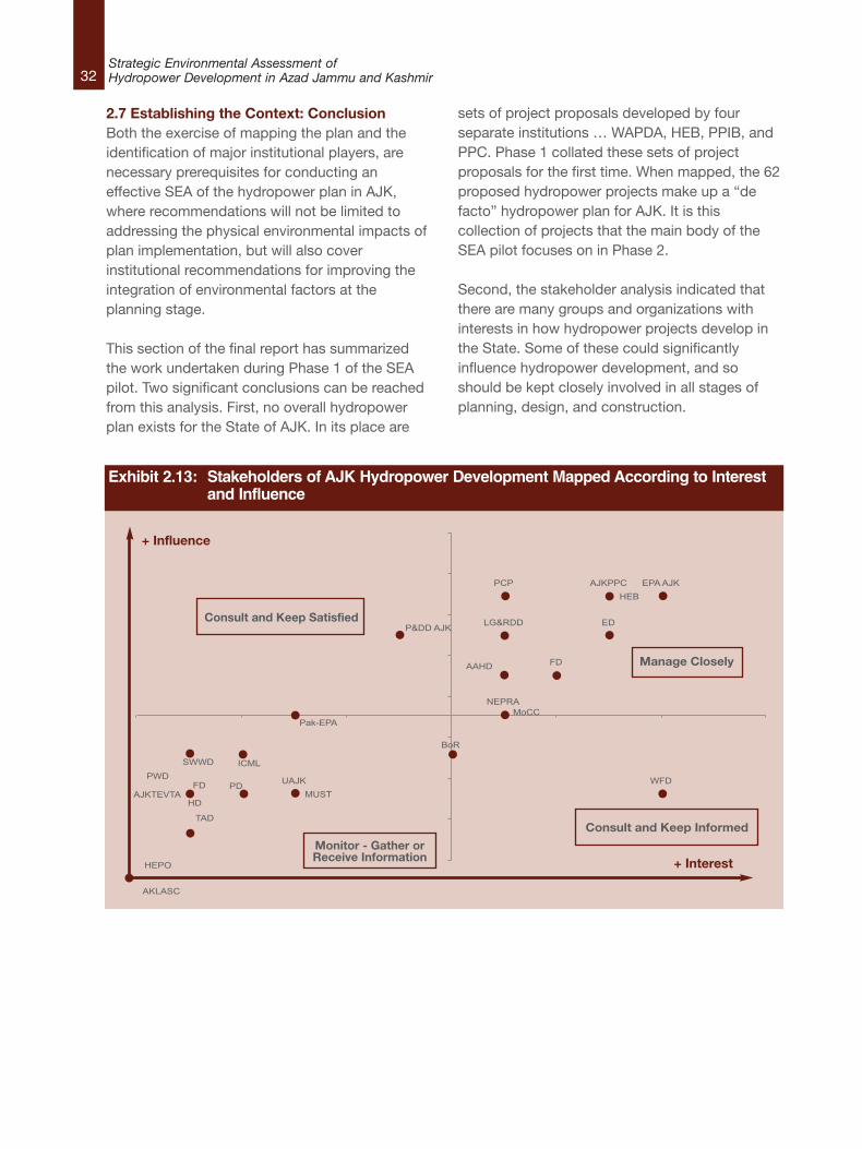
2.7 Establishing the Context: ConclusionBoth the exercise of mapping the plan and theidentification of major institutional players, arenecessary prerequisites for conducting aneffective SEA of the hydropower plan in AJK,where recommendations will not be limited toaddressing the physical environmental impacts ofplan implementation, but will also coverinstitutional recommendations for improving theintegration of environmental factors at theplanning stage.
This section of the final report has summarizedthe work undertaken during Phase 1 of the SEApilot. Two significant conclusions can be reachedfrom this analysis. First, no overall hydropowerplan exists for the State of AJK. In its place are
sets of project proposals developed by fourseparate institutions … WAPDA, HEB, PPIB, andPPC. Phase 1 collated these sets of projectproposals for the first time. When mapped, the 62proposed hydropower projects make up a “defacto” hydropower plan for AJK. It is thiscollection of projects that the main body of theSEA pilot focuses on in Phase 2.
Second, the stakeholder analysis indicated thatthere are many groups and organizations withinterests in how hydropower projects develop inthe State. Some of these could significantlyinfluence hydropower development, and soshould be kept closely involved in all stages ofplanning, design, and construction.
EPA AJK HEB
AJKPPC
ED
PCP
LG&RDD
FD
WFD
AAHD
P&DD AJK
MoCC NEPRA
BoR
Pak-EPA
UAJK MUST
ICML
HD
PD AJKTEVTA
PWD FD
SWWD
TAD
AKLASC
HEPO
Exhibit 2.13: Stakeholders of AJK Hydropower Development Mapped According to Interest and Influence
+ Influence
+ Interest
Consult and Keep Satisfied
Manage Closely
Monitor - Gather orReceive Information
Consult and Keep Informed
33Strategic Environmental Assessment of
Hydropower Development in Azad Jammu and Kashmir
3.1 IntroductionThe purpose of SEA is to examine the environmental and social impacts thatmay emanate as a result of the introduction of a new policy, plan, orprogramme. Section 2 showed that the current hydropower plan may result inapproximately 60 new HPPs being developed in AJK in the medium term.Depending on their size and siting, these projects may not necessarily result insignificant adverse impacts when they are assessed individually. However,when looked at as a whole, their cumulative impact could be significant.Because we do not know exactly where each of the HPPs will be sited, nor arewe sure of the specifics of their design, this SEA pilot focuses on the overallcumulative impacts that may result from implementation of the hydropowerplan as a whole.
This section of the final report summarizes the work that was undertakenduring Phase 2 of the SEA pilot study. The objective was to assist the AJKauthorities to identify the scale, diversity, magnitude and complexity of thepotential environmental and social impacts emanating from the developmentof the de facto Plan, and to identify the areas and river sections most sensitiveto those impacts. Phase 2 also aimed to provide the authorities with a guide tohelp direct the focus of further detailed EIA studies that may need to beundertaken as part of the design of specific projects.
3.2 Cumulative Assessment MethodologyExhibit 3.1 outlines the methodological approach taken in this study. In Step 1,we define and categorize the proposed HPPs as listed in Exhibit 2.1. Wepresent this discussion in Section 3.3.1 of this report. In Step 2, we outline thestructural design features of a selection of proposed HPPs of differinggeneration capacity. This information is presented in Section 3.3.2 and Section3.3.3.
This background material allows us, in Step 3, to define the generic drivers ofpotential environmental and social impacts. Categorizing HPPs into differenttypes based on the drivers of impacts helps identify the key issues that are tobecome the focus of the study and the recommendations that will result fromit. The results of this exercise are shown in Section 3.3.4.
3. Phase 2: Cumulative Impacts of Hydropower Projects
34Strategic Environmental Assessment ofHydropower Development in Azad Jammu and Kashmir
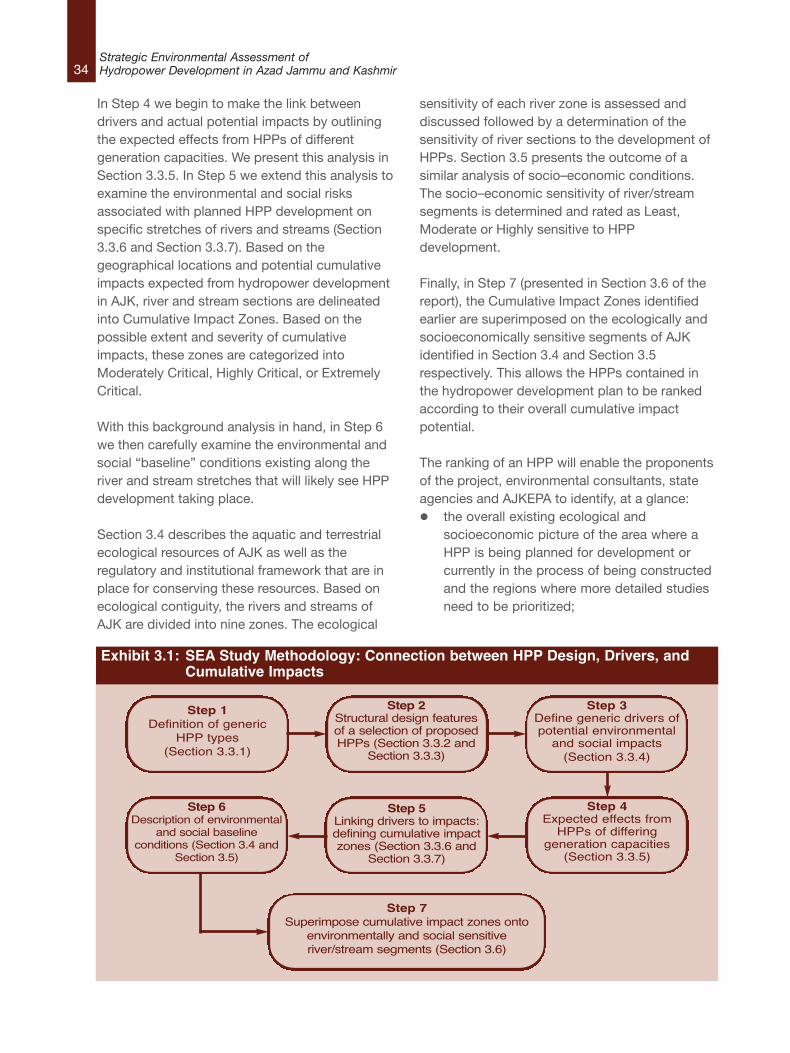
In Step 4 we begin to make the link betweendrivers and actual potential impacts by outliningthe expected effects from HPPs of differentgeneration capacities. We present this analysis inSection 3.3.5. In Step 5 we extend this analysis toexamine the environmental and social risksassociated with planned HPP development onspecific stretches of rivers and streams (Section3.3.6 and Section 3.3.7). Based on thegeographical locations and potential cumulativeimpacts expected from hydropower developmentin AJK, river and stream sections are delineatedinto Cumulative Impact Zones. Based on thepossible extent and severity of cumulativeimpacts, these zones are categorized intoModerately Critical, Highly Critical, or ExtremelyCritical.
With this background analysis in hand, in Step 6we then carefully examine the environmental andsocial “baseline” conditions existing along theriver and stream stretches that will likely see HPPdevelopment taking place.
Section 3.4 describes the aquatic and terrestrialecological resources of AJK as well as theregulatory and institutional framework that are inplace for conserving these resources. Based onecological contiguity, the rivers and streams ofAJK are divided into nine zones. The ecological
sensitivity of each river zone is assessed anddiscussed followed by a determination of thesensitivity of river sections to the development ofHPPs. Section 3.5 presents the outcome of asimilar analysis of socio–economic conditions.The socio–economic sensitivity of river/streamsegments is determined and rated as Least,Moderate or Highly sensitive to HPPdevelopment.
Finally, in Step 7 (presented in Section 3.6 of thereport), the Cumulative Impact Zones identifiedearlier are superimposed on the ecologically andsocioeconomically sensitive segments of AJKidentified in Section 3.4 and Section 3.5respectively. This allows the HPPs contained inthe hydropower development plan to be rankedaccording to their overall cumulative impactpotential.
The ranking of an HPP will enable the proponentsof the project, environmental consultants, stateagencies and AJKEPA to identify, at a glance:l the overall existing ecological and
socioeconomic picture of the area where aHPP is being planned for development orcurrently in the process of being constructedand the regions where more detailed studiesneed to be prioritized;
Exhibit 3.1: SEA Study Methodology: Connection between HPP Design, Drivers, and Cumulative Impacts
Step 1Definition of generic
HPP types(Section 3.3.1)
Step 2Structural design featuresof a selection of proposedHPPs (Section 3.3.2 and
Section 3.3.3)
Step 3Define generic drivers ofpotential environmentaland social impacts(Section 3.3.4)
Step 4Expected effects fromHPPs of differing
generation capacities(Section 3.3.5)
Step 5Linking drivers to impacts:defining cumulative impactzones (Section 3.3.6 and
Section 3.3.7)
Step 7Superimpose cumulative impact zones onto
environmentally and social sensitiveriver/stream segments (Section 3.6)
Step 6Description of environmental
and social baselineconditions (Section 3.4 and
Section 3.5)
35Strategic Environmental Assessment of
Hydropower Development in Azad Jammu and Kashmir
l the scale of the impact an HPP will have onthe ecology and socioeconomic condition ofthe area where it will be located;
l the contribution of each HPP to the overallimpacts from the development of all theHPPs included in the Plan;
l the potential need for a change of qualifyingconditions for either EIA or IEE studies fordifferent HPPs and the level of detail in whichthe ecological and socioeconomic impactassessment studies need to be conducted fortargeted projects;
l the role and significance of coordinationbetween HEB, PPC, WAPDA, PPIB andAJKEPA in developing the hydropower plan ina manner which minimizes impacts;
l an opportunity for revising the Plan as awhole or revising the type, size, layout andstructural components of a HPP to utilize anybenefit from other HPPs being built in thevicinity; and,
l the regions in AJK where public awarenesscampaigns need to be organized by thegovernment to help monitor HPPs during theconstruction and operation phase.
3.3 Categorizing Hydroelectric Power Projectsand Defining Impact DriversThis section of the report focuses on thecharacteristics of impacts emanating fromproposed HPPs. It outlines the design features ofdifferent types of hydropower projects, anddelineates the nature of likely constructionactivities. It then attempts to categorize impactdrivers. Understanding the nature and scale of thedrivers can help in the assessment of the severityand extent of different impacts.
Impacts that could arise from the development ofthe Plan will vary in severity and magnitude. Afterthe categorization of the drivers of impacts, thesection examines the indicators of environmentaland social impacts of individual HPPs in general;identifies those relevant to the geographic,topographic and socioeconomic context of AJK;
and categorizes them based on the likelihood ofthe impact arising, the magnitude of the effect,and the scale of mitigation and monitoring thatwill be required to control them.
The locations of the projects and their individualimpacts then allow for different river zones to beidentified based on the cluster of HPPs ofdifferent sizes within close geographic proximity.The zones help to indicate the regions in AJK thatare environmentally and socioeconomically proneto the impacts of the development of the Plan andrequire greater intervention in the planningprocess.
The section concludes by focusing on thecumulative impacts of the HPPs.
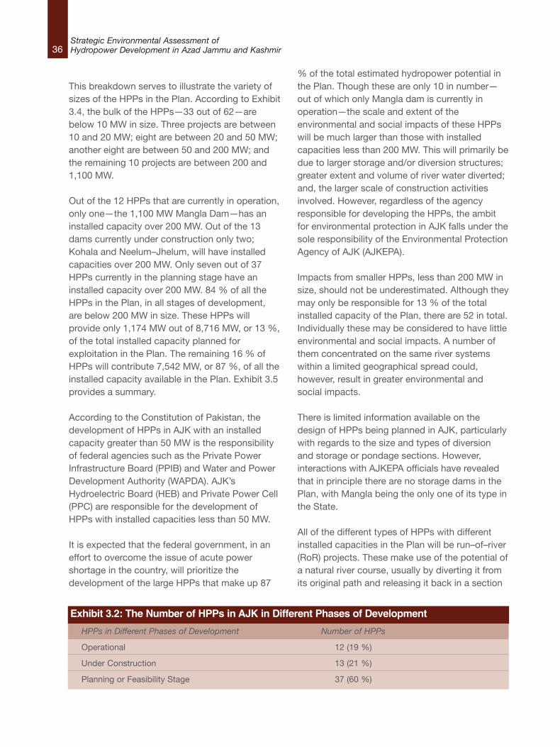
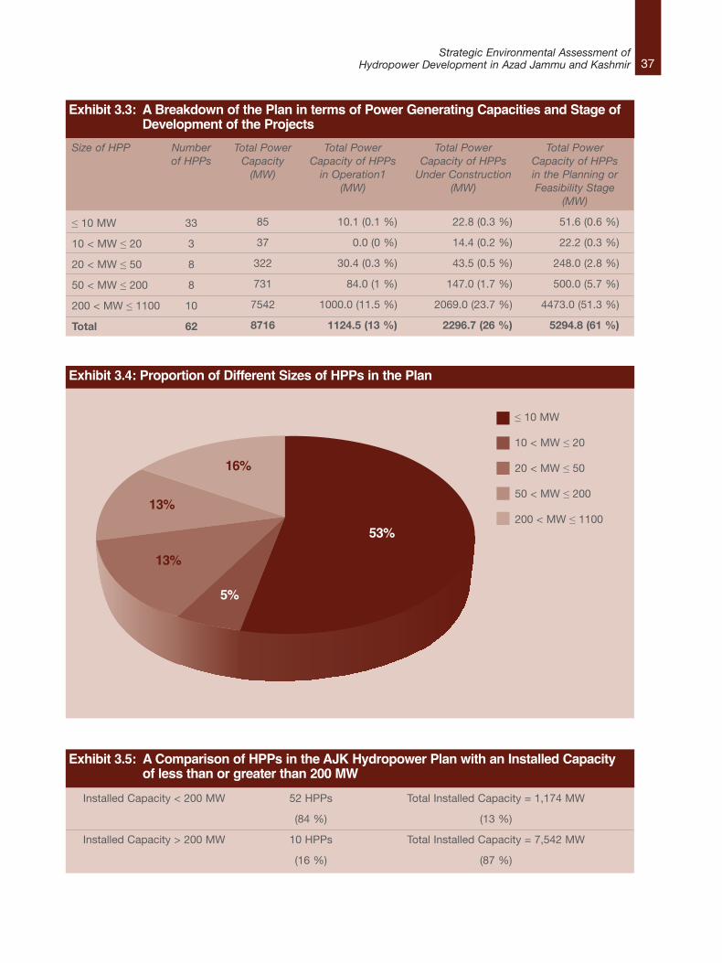
3.3.1 Step 1: Categorizing Proposed HPPsExhibit 3.2 indicates the number of HPPs indifferent stages of development in AJK. Out of atotal of 62 HPPs in the Plan, 12 are currently inoperation; 13 are under construction, and theremaining 37 projects are in the planning orfeasibility stage at the time of drafting this report.According to Exhibit 3.3, out of an estimated totalinstalled capacity of 8,716 MW available from thePlan, 1,124 MW or 13 % of the available capacityis already online; 2,297 MW or 26 % is underconstruction; and 5,295 MW or 61 % of theremaining capacity is currently in the feasibility orplanning stage.
In terms of installed capacities, the largest HPP isthe online and operational 1,100 MW ManglaDam, while the smallest HPP, currently in theplanning phase, has a proposed installed capacityof 0.05 MW. To illustrate the spread of the HPPs interms of their installed capacities, the followinganalysis splits them into four categories:l less than 10 MW,
l between 10 and 20 MW,
l between 20 and 50 MW,
l between 50 and 200 MW, and,
l greater than 200 MW.
36Strategic Environmental Assessment ofHydropower Development in Azad Jammu and Kashmir
This breakdown serves to illustrate the variety ofsizes of the HPPs in the Plan. According to Exhibit3.4, the bulk of the HPPs—33 out of 62—arebelow 10 MW in size. Three projects are between10 and 20 MW; eight are between 20 and 50 MW;another eight are between 50 and 200 MW; andthe remaining 10 projects are between 200 and1,100 MW.
Out of the 12 HPPs that are currently in operation,only one—the 1,100 MW Mangla Dam—has aninstalled capacity over 200 MW. Out of the 13dams currently under construction only two;Kohala and Neelum–Jhelum, will have installedcapacities over 200 MW. Only seven out of 37HPPs currently in the planning stage have aninstalled capacity over 200 MW. 84 % of all theHPPs in the Plan, in all stages of development,are below 200 MW in size. These HPPs willprovide only 1,174 MW out of 8,716 MW, or 13 %,of the total installed capacity planned forexploitation in the Plan. The remaining 16 % ofHPPs will contribute 7,542 MW, or 87 %, of all theinstalled capacity available in the Plan. Exhibit 3.5provides a summary.
According to the Constitution of Pakistan, thedevelopment of HPPs in AJK with an installedcapacity greater than 50 MW is the responsibilityof federal agencies such as the Private PowerInfrastructure Board (PPIB) and Water and PowerDevelopment Authority (WAPDA). AJK’sHydroelectric Board (HEB) and Private Power Cell(PPC) are responsible for the development ofHPPs with installed capacities less than 50 MW.
It is expected that the federal government, in aneffort to overcome the issue of acute powershortage in the country, will prioritize thedevelopment of the large HPPs that make up 87
% of the total estimated hydropower potential inthe Plan. Though these are only 10 in number—out of which only Mangla dam is currently inoperation—the scale and extent of theenvironmental and social impacts of these HPPswill be much larger than those with installedcapacities less than 200 MW. This will primarily bedue to larger storage and/or diversion structures;greater extent and volume of river water diverted;and, the larger scale of construction activitiesinvolved. However, regardless of the agencyresponsible for developing the HPPs, the ambitfor environmental protection in AJK falls under thesole responsibility of the Environmental ProtectionAgency of AJK (AJKEPA).
Impacts from smaller HPPs, less than 200 MW insize, should not be underestimated. Although theymay only be responsible for 13 % of the totalinstalled capacity of the Plan, there are 52 in total.Individually these may be considered to have littleenvironmental and social impacts. A number ofthem concentrated on the same river systemswithin a limited geographical spread could,however, result in greater environmental andsocial impacts.
There is limited information available on thedesign of HPPs being planned in AJK, particularlywith regards to the size and types of diversionand storage or pondage sections. However,interactions with AJKEPA officials have revealedthat in principle there are no storage dams in thePlan, with Mangla being the only one of its type inthe State.
All of the different types of HPPs with differentinstalled capacities in the Plan will be run–of–river(RoR) projects. These make use of the potential ofa natural river course, usually by diverting it fromits original path and releasing it back in a section
Exhibit 3.2: The Number of HPPs in AJK in Different Phases of Development
HPPs in Different Phases of Development Number of HPPs
Operational 12 (19 %)
Under Construction 13 (21 %)
Planning or Feasibility Stage 37 (60 %)
37Strategic Environmental Assessment of
Hydropower Development in Azad Jammu and Kashmir
Exhibit 3.5: A Comparison of HPPs in the AJK Hydropower Plan with an Installed Capacity of less than or greater than 200 MW
Installed Capacity < 200 MW 52 HPPs Total Installed Capacity = 1,174 MW
(84 %) (13 %)
Installed Capacity > 200 MW 10 HPPs Total Installed Capacity = 7,542 MW
(16 %) (87 %)
Exhibit 3.3: A Breakdown of the Plan in terms of Power Generating Capacities and Stage of Development of the Projects
Size of HPP
≤ 10 MW
10 < MW ≤ 20
20 < MW ≤ 50
50 < MW ≤ 200
200 < MW ≤ 1100
Total
Numberof HPPs
33
3
8
8
10
62
Total PowerCapacity(MW)
85
37
322
731
7542
8716
Total PowerCapacity of HPPsin Operation1
(MW)
10.1 (0.1 %)
0.0 (0 %)
30.4 (0.3 %)
84.0 (1 %)
1000.0 (11.5 %)
1124.5 (13 %)
Total PowerCapacity of HPPsUnder Construction
(MW)
22.8 (0.3 %)
14.4 (0.2 %)
43.5 (0.5 %)
147.0 (1.7 %)
2069.0 (23.7 %)
2296.7 (26 %)
Total PowerCapacity of HPPsin the Planning orFeasibility Stage
(MW)
51.6 (0.6 %)
22.2 (0.3 %)
248.0 (2.8 %)
500.0 (5.7 %)
4473.0 (51.3 %)
5294.8 (61 %)
Exhibit 3.4: Proportion of Different Sizes of HPPs in the Plan
53%
16%
13%
13%
5%
≤ 10 MW
10 < MW ≤ 20
20 < MW ≤ 50
50 < MW ≤ 200
200 < MW ≤ 1100
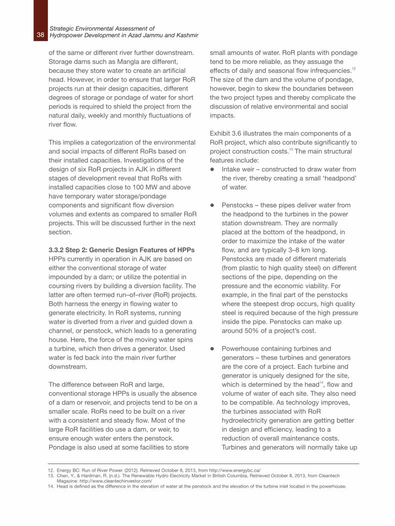
of the same or different river further downstream.Storage dams such as Mangla are different,because they store water to create an artificialhead. However, in order to ensure that larger RoRprojects run at their design capacities, differentdegrees of storage or pondage of water for shortperiods is required to shield the project from thenatural daily, weekly and monthly fluctuations ofriver flow.
This implies a categorization of the environmentaland social impacts of different RoRs based ontheir installed capacities. Investigations of thedesign of six RoR projects in AJK in differentstages of development reveal that RoRs withinstalled capacities close to 100 MW and abovehave temporary water storage/pondagecomponents and significant flow diversionvolumes and extents as compared to smaller RoRprojects. This will be discussed further in the nextsection.
3.3.2 Step 2: Generic Design Features of HPPsHPPs currently in operation in AJK are based oneither the conventional storage of waterimpounded by a dam; or utilize the potential incoursing rivers by building a diversion facility. Thelatter are often termed run–of–river (RoR) projects.Both harness the energy in flowing water togenerate electricity. In RoR systems, runningwater is diverted from a river and guided down achannel, or penstock, which leads to a generatinghouse. Here, the force of the moving water spinsa turbine, which then drives a generator. Usedwater is fed back into the main river furtherdownstream.
The difference between RoR and large,conventional storage HPPs is usually the absenceof a dam or reservoir, and projects tend to be on asmaller scale. RoRs need to be built on a riverwith a consistent and steady flow. Most of thelarge RoR facilities do use a dam, or weir, toensure enough water enters the penstock.Pondage is also used at some facilities to store
small amounts of water. RoR plants with pondagetend to be more reliable, as they assuage theeffects of daily and seasonal flow infrequencies.12
The size of the dam and the volume of pondage,however, begin to skew the boundaries betweenthe two project types and thereby complicate thediscussion of relative environmental and socialimpacts.
Exhibit 3.6 illustrates the main components of aRoR project, which also contribute significantly toproject construction costs.13 The main structuralfeatures include:l Intake weir – constructed to draw water from
the river, thereby creating a small ‘headpond’of water.
l Penstocks – these pipes deliver water fromthe headpond to the turbines in the powerstation downstream. They are normallyplaced at the bottom of the headpond, inorder to maximize the intake of the waterflow, and are typically 3–8 km long.Penstocks are made of different materials(from plastic to high quality steel) on differentsections of the pipe, depending on thepressure and the economic viability. Forexample, in the final part of the penstockswhere the steepest drop occurs, high qualitysteel is required because of the high pressureinside the pipe. Penstocks can make uparound 50% of a project’s cost.
l Powerhouse containing turbines andgenerators – these turbines and generatorsare the core of a project. Each turbine andgenerator is uniquely designed for the site,which is determined by the head14, flow andvolume of water of each site. They also needto be compatible. As technology improves,the turbines associated with RoRhydroelectricity generation are getting betterin design and efficiency, leading to areduction of overall maintenance costs.Turbines and generators will normally take up
38Strategic Environmental Assessment ofHydropower Development in Azad Jammu and Kashmir
12. Energy BC: Run of River Power. (2012). Retrieved October 8, 2013, from http://www.energybc.ca/13. Chen, Y., & Hardman, R. (n.d.). The Renewable Hydro Electricity Market in British Columbia. Retrieved October 8, 2013, from Cleantech
Magazine: http://www.cleantechinvestor.com/14. Head is defined as the difference in the elevation of water at the penstock and the elevation of the turbine inlet located in the powerhouse.
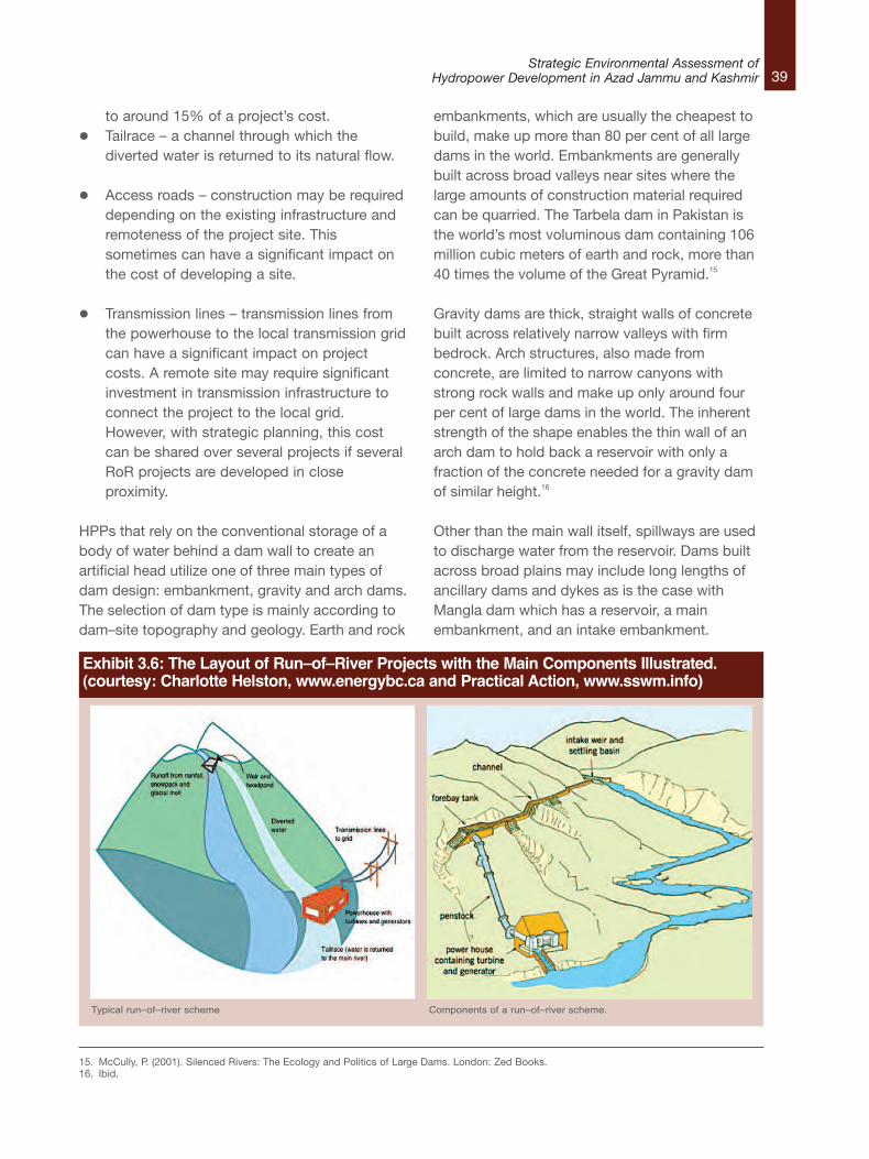
to around 15% of a project’s cost.l Tailrace – a channel through which the
diverted water is returned to its natural flow.
l Access roads – construction may be requireddepending on the existing infrastructure andremoteness of the project site. Thissometimes can have a significant impact onthe cost of developing a site.
l Transmission lines – transmission lines fromthe powerhouse to the local transmission gridcan have a significant impact on projectcosts. A remote site may require significantinvestment in transmission infrastructure toconnect the project to the local grid.However, with strategic planning, this costcan be shared over several projects if severalRoR projects are developed in closeproximity.
HPPs that rely on the conventional storage of abody of water behind a dam wall to create anartificial head utilize one of three main types ofdam design: embankment, gravity and arch dams.The selection of dam type is mainly according todam–site topography and geology. Earth and rock
embankments, which are usually the cheapest tobuild, make up more than 80 per cent of all largedams in the world. Embankments are generallybuilt across broad valleys near sites where thelarge amounts of construction material requiredcan be quarried. The Tarbela dam in Pakistan isthe world’s most voluminous dam containing 106million cubic meters of earth and rock, more than40 times the volume of the Great Pyramid.15
Gravity dams are thick, straight walls of concretebuilt across relatively narrow valleys with firmbedrock. Arch structures, also made fromconcrete, are limited to narrow canyons withstrong rock walls and make up only around fourper cent of large dams in the world. The inherentstrength of the shape enables the thin wall of anarch dam to hold back a reservoir with only afraction of the concrete needed for a gravity damof similar height.16
Other than the main wall itself, spillways are usedto discharge water from the reservoir. Dams builtacross broad plains may include long lengths ofancillary dams and dykes as is the case withMangla dam which has a reservoir, a mainembankment, and an intake embankment.
39Strategic Environmental Assessment of
Hydropower Development in Azad Jammu and Kashmir
15. McCully, P. (2001). Silenced Rivers: The Ecology and Politics of Large Dams. London: Zed Books.16. Ibid.
Exhibit 3.6: The Layout of Run–of–River Projects with the Main Components Illustrated.(courtesy: Charlotte Helston, www.energybc.ca and Practical Action, www.sswm.info)
Typical run–of–river scheme Components of a run–of–river scheme.
40Strategic Environmental Assessment ofHydropower Development in Azad Jammu and Kashmir
3.3.3 Step 2: Specific Design Features ofProposed HPPs in AJKThis section summarizes the main features ofdifferent types of HPPs in AJK’s hydropowerdevelopment plan. A combination of timeconstraints and the difficulty in obtaining publicrecords from government agencies limited thenumber of HPPs considered in this section to thefollowing seven:l 1.15 MW Kathai–III,
l 4.8 MW Rialli–II,
l 35 MW Nagdar,
l 40 MW Dowarian,
l 100 MW Gulpur,
l 900 MW Neelum–Jhelum, and,
l 1,100 MW Mangla.
Information for the Kathai, Rialli, Nagdar andDowarian HPPs was extracted from InitialEnvironmental Examination (IEE) reports collectedfrom AJKEPA. Information for Gulpur andNeelum–Jhelum HPPs was available in–house atHBP due to previous project experience with thetwo. Extensive information on Mangla is availableon the internet.
Despite the paucity of information, an analysis ofthe structural features of the seven HPPs listedabove—which cover a range of installedcapacities from 1.15 MW to 1,100 MW— issufficient in providing an accurate representationof the main structural features and componentsfor HPPs of different sizes in the Plan.
Out of the seven, Mangla is the only HPP basedon conventional storage of water behind a damwall. The remaining six are all RoRs with differenttypes and sizes of diversion structures; and,different extents of river sections and watervolumes diverted. The next section describestheir main features and Exhibit 3.7 illustrates theirlocation.
Kathai–III 1.15 MWThe 1.15 MW Kathai–III is a RoR located on theQazi Nag Nullah , a tributary of the Jhelum River.17
A 166.74 m long inundation canal diverts riverwater through silt excluders into a 562 m longpower channel. The channel ends into a forebaywith a storage capacity of 328 m3. A 78 m longpenstock with an outside diameter of 1.5 m takesthe water into a Francis turbine (Exhibit 3.8) with ashaft power capacity of 385 kW. While the cost ofthe project is unknown, estimates from projects ofsimilar sizes in the AJK shown in Exhibit 3.9 placethe approximate costs in the range of Rs.300million (US$ 2.8 million). Construction time isexpected to be around three years.
17. The term ‘nullah’ describes a stream. The two words, stream and nullah, will be used interchangeably in this report.
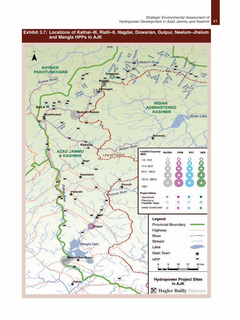
41Strategic Environmental Assessment of
Hydropower Development in Azad Jammu and Kashmir
Exhibit 3.7: Locations of Kathai–III, Rialli–II, Nagdar, Dowarian, Gulpur, Neelum–Jhelum and Mangla HPPs in AJK
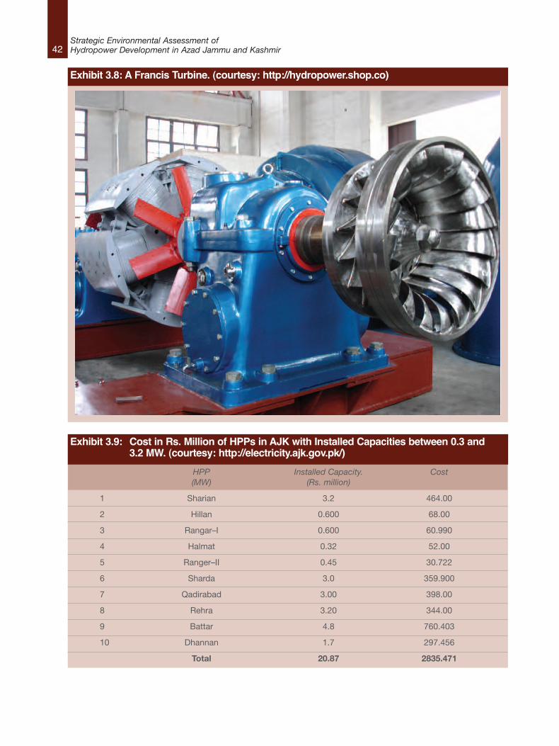
42Strategic Environmental Assessment ofHydropower Development in Azad Jammu and Kashmir
Exhibit 3.8: A Francis Turbine. (courtesy: http://hydropower.shop.co)
HPP Installed Capacity. Cost(MW) (Rs. million)
1 Sharian 3.2 464.00
2 Hillan 0.600 68.00
3 Rangar–I 0.600 60.990
4 Halmat 0.32 52.00
5 Ranger–II 0.45 30.722
6 Sharda 3.0 359.900
7 Qadirabad 3.00 398.00
8 Rehra 3.20 344.00
9 Battar 4.8 760.403
10 Dhannan 1.7 297.456
Total 20.87 2835.471
Exhibit 3.9: Cost in Rs. Million of HPPs in AJK with Installed Capacities between 0.3 and3.2 MW. (courtesy: http://electricity.ajk.gov.pk/)

43Strategic Environmental Assessment of
Hydropower Development in Azad Jammu and Kashmir
Exhibit 3.10: Man checking the grid at aTyrolean Weir. Tanzania. (Photo: D.Bourman, Aqua for All, courtesy:www.akvopedia.org)
Exhibit 3.12: General Setup of a Pelton Wheel. (courtesy: Ron Shannon http://permaculturewest.org.au/)
Exhibit 3.11: The Elements of the IntakeStructure with a Tyrolean Weir(courtesy: www.nzdl.org)
Rialli–II 4.8 MWThe 4.8 MW Rialli–II is a RoR located on theGhoriwala Nullah which flows into the NeelumRiver. The main structural features include a 27 mlong Tyrolean weir18 (Exhibit 10 and Exhibit 3.11)built in the nullah which laterally diverts river flowinto an approach channel with a 33 m long siltexcluder. A settling basin is built in the channel toremove sand and silt from the water. The siltexcluder provides a passage for sediments at thebottom of the water channel back into the riverwhile the remaining water goes into a 4,000 mlong power channel.
The power channel directs the water into a 40 mlong forebay with a storage capacity of 1,415 m3.From the forebay, a 150 m high spillway takes thewater into a 655 m long penstock where takes upthe form of a single jet of water and ends byturning a Pelton Wheel turbine (Exhibit 3.12). Theturbine has a capacity of 2,510 kW and cangenerate up to 3,300 V. While the cost of theproject is unknown, estimates from projects ofsimilar sizes in the AJK place the approximatecosts in the range of Rs.500 million (US$ 4.7million). It is expected to take approximately threeyears to construct.
18. A Tyrolean weir is a water inlet structure in which water is abstracted from the main flow through a screen over a gutter. The bars of the screen are laid inthe direction of the current and inclined in the direction of the tail water so that coarse bed load is kept out of the collection canal and transported furtherdownstream. The gutter is usually made of concrete and built into the river bed. From the gutter, water enters a pipeline, which drains into a sedimentationtank and then flows by gravity into the rest of the system. Tyrolean Weir. (2010, October). Retrieved August 8, 2013, from akvopedia:http://akvopedia.org/wiki/Tyrolean_weir and Lauterjung, H., & Schmidt, G. (1989). Planning of intake structures. Brauschweig: Friedr. Vieweg & Sohn.

44Strategic Environmental Assessment ofHydropower Development in Azad Jammu and Kashmir
Nagdar 35 MWThe 35 MW Nagdar is a RoR HPP planned on theperennial flows of the Nagdar Nullah, a right banktributary of the Neelum River. The project layoututilizes a head of 470 m and a design discharge of9 m3/s. A concrete weir with a height of 6 mabove the nullah bed will divert water into a powerintake with a gross intake area of 12 m2. Aconnecting channel between the weir and thepower intake flows at a slope of 1 in 500 alongthe right side of the nullah. The open channel hasa maximum capacity of 9 m3/s and a length of 40m up to the silt excluder. Upon reaching the siltexcluders, suspended particles with a diameterabove 0.22 mm are discharged into twochambers each with a width of 4 m and a lengthof 54 m. Downstream of the excluder, waterenters the power intake tunnel with anapproximate length of 3,840 m from the inlet tothe surge tank. The tunnel has a design capacityof 9 m3/s and acts as a low pressure tunnel. Fromthe surge tank to the inlet of the turbine, pressureshaft of 2.1 m diameter would be excavated witha 420 m concrete lined vertical drop followed by asteel lined 260 m horizontal section. Water thenenters a power house carrying 4 Pelton wheelturbines. The estimated cost of Nagdar is Rs. 6billion (US$ 52 million). It is expected to takeapproximately four years to construct.
Dowarian 40 MWThe 40 MW Dowarian HPP is a RoR on theDowarian nullah, a right bank tributary of theNeelum River. A concrete weir with a height of 8m from the nullah bed and a length of 24 macross will divert water to a turbine through ahead of 497 m. The weir directs water into apower intake with a gross area of 12.0 m2 at amaximum rate of 11.60 m3/s. Water then goesthrough a 158 m long connecting channel with awidth of 2.8 m and a depth of 1.8 m. Theconnecting channel has a silt excluder whichremoves suspended particles with a diameterabove 0.22 mm.
Water flowing out of the silt excluder then enters a2,200 m long power tunnel with a design capacityof 9.6 m3/s. This tunnel ends at a surge tankwhich helps accommodate fluctuations in waterlevels and maintains the design water level in theheadrace tunnel. Water from the surge tank endsup at the turbines through a 1,180 m longpenstock with a diameter of 1.7 m and a designcapacity of 9.60 m3/s. The penstock is placed asan embedded pipe laid over terraces of theDowarian village with varying angles of 20 to 45°.Water finally enters a powerhouse hosting fourPelton turbines each with a capacity of 10 MW.The outflow from the powerhouse is dischargedinto the Neelum River through a 50 m tailracechannel. The estimated cost of Dowarian is Rs 4billion19 (US$ 40 million). It is expected to takeapproximately four years to construct.
Gulpur 100 MWGulpur HPP, with a 100 MW power generationcapacity and annual generation capability of 465gigawatt–hour (GWh), is also a RoR project. Theproject site is in the Kotli District of AJK andlocated about 5 km south of Kotli town on thePoonch River, a tributary of Jhelum River.
Unlike Kathai, Rialli, Nagdar and Dowarian RoRswhich rely on diversion structures such as weirsand inundation canals, this project will require theconstruction of a 32 m dam on the Poonch Riverdownstream of its confluence with Ban Nullah.The dam will create a reservoir with a volume of21.9 million m3. The water from the reservoir willbe diverted to a 3.1 km head race tunnel with adiameter of 7.75 m. The intake of the tunnel willbe located in the Ban Nullah about 2 km upstreamof the confluence of the Ban Nullah with thePoonch River. A powerhouse with three Francisturbines will be constructed on the left bank ofPoonch River about 6 km downstream of the damand then discharged back into the Poonch River.According to the feasibility study of the Gulpurproject, the total expected cost is Rs. 17 billion20
19. Government of Azad Jammu and Kashmir. (n.d.). Development Projects. Retrieved October 5, 2013, from Electricity Department:http://electricity.ajk.gov.pk/
20. Staff Report. (2013, September 10). Agreement for 100 MW Gulpur Hydropower Project signed. Retrieved October 5, 2013, from Daily Times:http://www.dailytimes.com.pk/
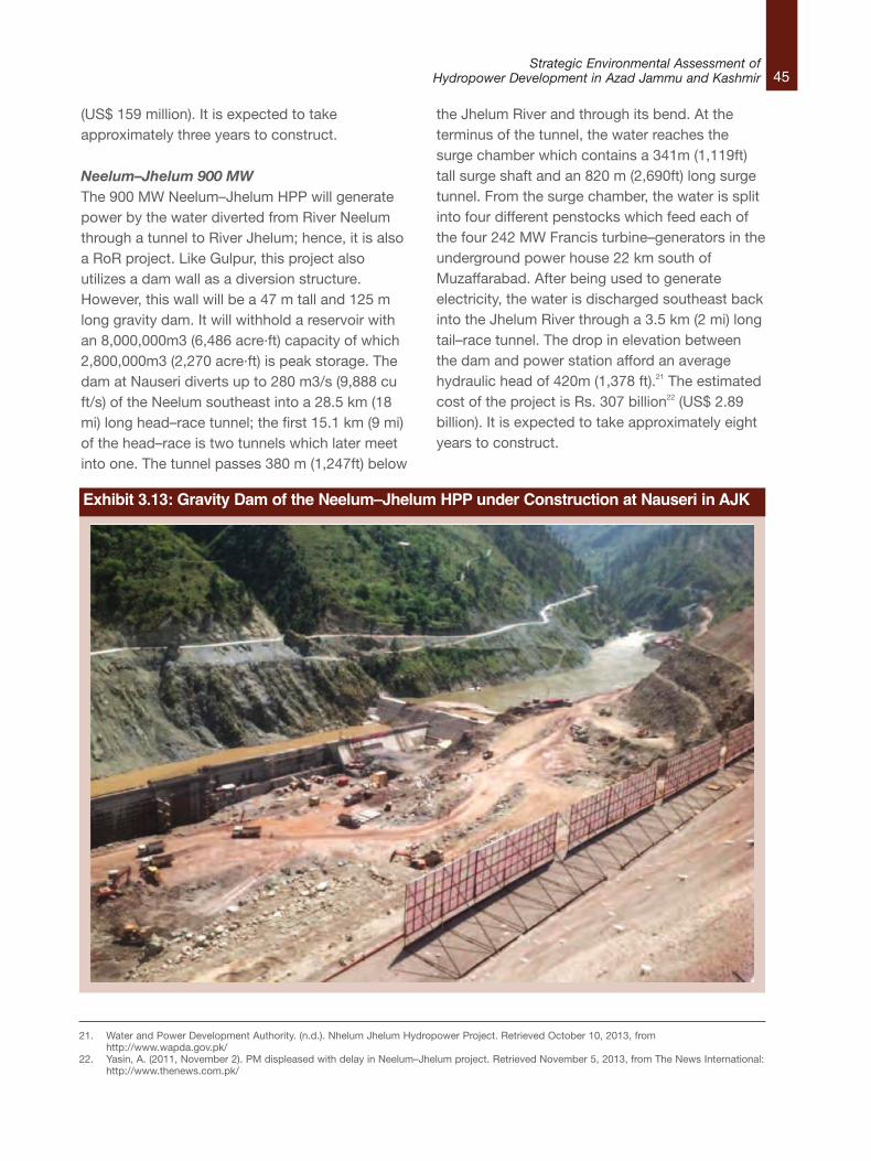
45Strategic Environmental Assessment of
Hydropower Development in Azad Jammu and Kashmir
(US$ 159 million). It is expected to takeapproximately three years to construct.
Neelum–Jhelum 900 MWThe 900 MW Neelum–Jhelum HPP will generatepower by the water diverted from River Neelumthrough a tunnel to River Jhelum; hence, it is alsoa RoR project. Like Gulpur, this project alsoutilizes a dam wall as a diversion structure.However, this wall will be a 47 m tall and 125 mlong gravity dam. It will withhold a reservoir withan 8,000,000m3 (6,486 acre·ft) capacity of which2,800,000m3 (2,270 acre·ft) is peak storage. Thedam at Nauseri diverts up to 280 m3/s (9,888 cuft/s) of the Neelum southeast into a 28.5 km (18mi) long head–race tunnel; the first 15.1 km (9 mi)of the head–race is two tunnels which later meetinto one. The tunnel passes 380 m (1,247ft) below
the Jhelum River and through its bend. At theterminus of the tunnel, the water reaches thesurge chamber which contains a 341m (1,119ft)tall surge shaft and an 820 m (2,690ft) long surgetunnel. From the surge chamber, the water is splitinto four different penstocks which feed each ofthe four 242 MW Francis turbine–generators in theunderground power house 22 km south ofMuzaffarabad. After being used to generateelectricity, the water is discharged southeast backinto the Jhelum River through a 3.5 km (2 mi) longtail–race tunnel. The drop in elevation betweenthe dam and power station afford an averagehydraulic head of 420m (1,378 ft).21 The estimatedcost of the project is Rs. 307 billion22 (US$ 2.89billion). It is expected to take approximately eightyears to construct.
21. Water and Power Development Authority. (n.d.). Nhelum Jhelum Hydropower Project. Retrieved October 10, 2013, fromhttp://www.wapda.gov.pk/
22. Yasin, A. (2011, November 2). PM displeased with delay in Neelum–Jhelum project. Retrieved November 5, 2013, from The News International:http://www.thenews.com.pk/
Exhibit 3.13: Gravity Dam of the Neelum–Jhelum HPP under Construction at Nauseri in AJK
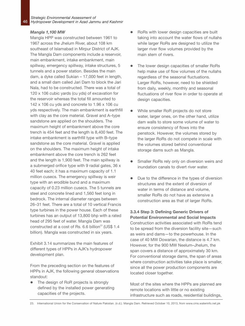
46Strategic Environmental Assessment ofHydropower Development in Azad Jammu and Kashmir
Mangla 1,100 MWMangla HPP was constructed between 1961 to1967 across the Jhelum River, about 108 kmsoutheast of Islamabad in Mirpur District of AJK.The Mangla Dam components include a reservoir,main embankment, intake embankment, mainspillway, emergency spillway, intake structures, 5tunnels and a power station. Besides the maindam, a dyke called Sukian – 17,000 feet in length,and a small dam called Jari Dam to block the JariNala, had to be constructed. There was a total of120 x 106 cubic yards (cu yds) of excavation forthe reservoir whereas the total fill amounted to142 x 106 cu yds and concrete to 1.96 x 10⁶ cuyds respectively. The main embankment is earthfillwith clay as the core material. Gravel and A–typesandstone are applied on the shoulders. Themaximum height of embankment above the coretrench is 454 feet and the length is 8,400 feet. Theintake embankment is earthfill type with B–typesandstone as the core material. Gravel is appliedon the shoulders. The maximum height of intakeembankment above the core trench is 262 feetand the length is 1,900 feet. The main spillway isa submerged orifice type with 9 radial gates, 36 x40 feet each; it has a maximum capacity of 1.1million cusecs. The emergency spillway is weirtype with an erodible bund and a maximumcapacity of 0.23 million cusecs. The 5 tunnels aresteel and concrete lined and 1,560 feet long inbedrock. The internal diameter ranges between26–31 feet. There are a total of 10 vertical Francistype turbines in the power house. Each of theseturbines has an output of 13,800 bhp with a ratedhead of 295 feet of water. Mangla Dam wasconstructed at a cost of Rs. 6.6 billion23 (US$ 1.4billion). Mangla was constructed in six years.
Exhibit 3.14 summarizes the main features ofdifferent types of HPPs in AJK’s hydropowerdevelopment plan.
From the preceding section on the features ofHPPs in AJK, the following general observationsstandout:l The design of RoR projects is strongly
defined by the installed power generatingcapacities of the projects.
l RoRs with lower design capacities are builttaking into account the water flows of nullahswhile larger RoRs are designed to utilize thelarger river flow volumes provided by themain stem of rivers.
l The lower design capacities of smaller RoRshelp make use of flow volumes of the nullahsregardless of the seasonal fluctuations.Larger RoRs, however, need to be shieldedfrom daily, weekly, monthly and seasonalfluctuations of river flow in order to operate atdesign capacities.
l While smaller RoR projects do not storewater, larger ones, on the other hand, utilizedam walls to store some volume of water toensure consistency of flows into thepenstock. However, the volumes stored bythe larger RoRs do not compete in scale withthe volumes stored behind conventionalstorage dams such as Mangla.
l Smaller RoRs rely only on diversion weirs andinundation canals to divert river water.
l Due to the difference in the types of diversionstructures and the extent of diversion ofwater in terms of distance and volume,smaller RoRs do not have as extensive aconstruction area as that of larger RoRs.
3.3.4 Step 3: Defining Generic Drivers ofPotential Environmental and Social ImpactsConstruction activities associated with RoRs tendto be spread from the diversion facility site—suchas weirs and dams—to the powerhouse. In thecase of 40 MW Dowarian, the distance is 4.7 km.However, for the 900 MW Neelum–Jhelum, thespan covers a distance of approximately 30 km.For conventional storage dams, the span of areaswhere construction activities take place is smaller,since all the power production components arelocated closer together.
Most of the sites where the HPPs are planned areremote locations with little or no existinginfrastructure such as roads, residential buildings,
23. International Union for the Conservation of Nature Pakistan. (n.d.). Mangla Dam. Retrieved October 10, 2013, from www.cms.waterinfo.net.pk
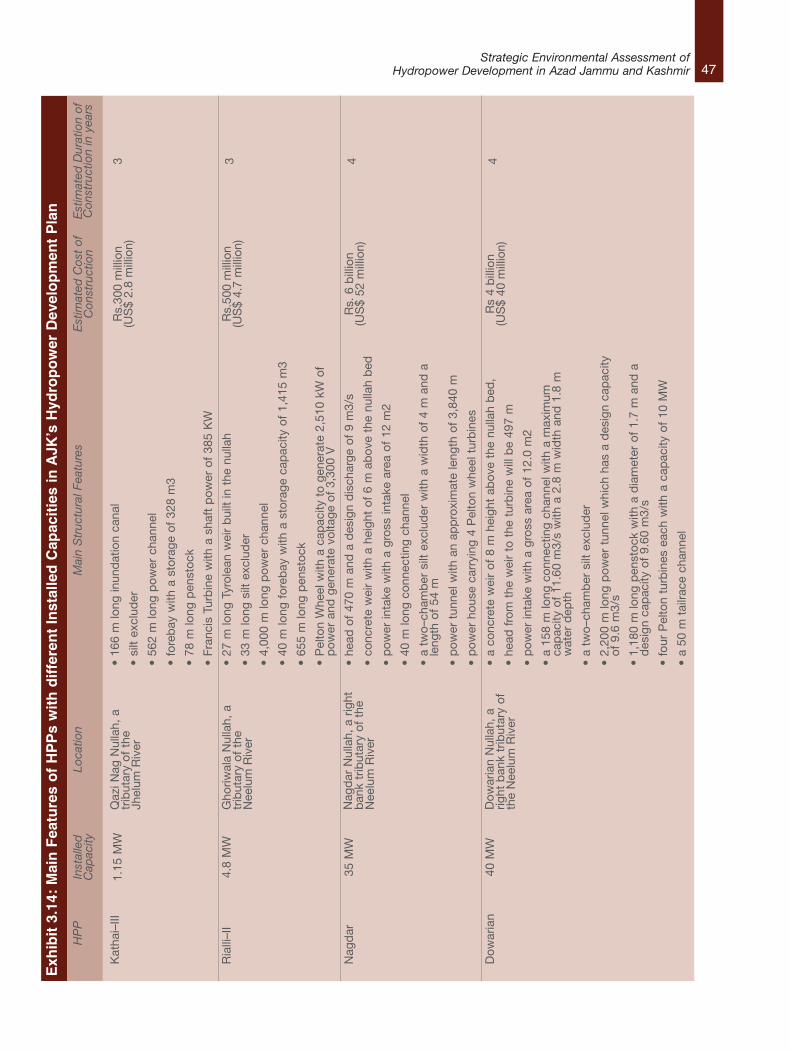
47Strategic Environmental Assessment of
Hydropower Development in Azad Jammu and Kashmir
Exhibit 3.14: Main Features of HPPs with different Installed Capacities in AJK’s Hydropower Development Plan
HPP
Kat
hai–
III
Ria
lli–I
I
Nag
dar
Dow
aria
n
Installed
Capacity
1.15
MW
4.8
MW
35 M
W
40 M
W
Location
Qaz
i Nag
Nul
lah,
atr
ibut
ary
of t
heJh
elum
Riv
er
Gho
riwal
a N
ulla
h, a
trib
utar
y of
the
Nee
lum
Riv
er
Nag
dar
Nul
lah,
a r
ight
ban
k tr
ibut
ary
of t
heN
eelu
m R
iver
Dow
aria
n N
ulla
h, a
right
ban
k tr
ibut
ary
ofth
e N
eelu
m R
iver
Main Structural Features
•16
6 m
long
inun
dat
ion
cana
l
• si
lt ex
clud
er
• 56
2 m
long
pow
er c
hann
el
• fo
reb
ay w
ith a
sto
rage
of
328
m3
• 78
m lo
ng p
enst
ock
• Fr
anci
s Tu
rbin
e w
ith a
sha
ft p
ower
of
385
KW
• 27
m lo
ng T
yrol
ean
wei
r b
uilt
in t
he n
ulla
h
• 33
m lo
ng s
ilt e
xclu
der
• 4,
000
m lo
ng p
ower
cha
nnel
• 40
m lo
ng f
oreb
ay w
ith a
sto
rage
cap
acity
of
1,41
5 m
3
• 65
5 m
long
pen
stoc
k
• P
elto
n W
heel
with
a c
apac
ity t
o ge
nera
te 2
,510
kW
of
pow
er a
nd g
ener
ate
volta
ge o
f 3,
300
V
• he
ad o
f 47
0 m
and
a d
esig
n d
isch
arge
of
9 m
3/s
• co
ncre
te w
eir
with
a h
eigh
t of
6 m
ab
ove
the
nulla
h b
ed
•p
ower
inta
ke w
ith a
gro
ss in
take
are
a of
12
m2
• 40
m lo
ng c
onne
ctin
g ch
anne
l
• a
two–
cham
ber
silt
exc
lud
er w
ith a
wid
th o
f 4
m a
nd a
leng
th o
f 54
m
•p
ower
tun
nel w
ith a
n ap
pro
xim
ate
leng
th o
f 3,
840
m
•p
ower
hou
se c
arry
ing
4 P
elto
n w
heel
tur
bin
es
•a
conc
rete
wei
r of
8 m
hei
ght
abov
e th
e nu
llah
bed
,
•he
ad f
rom
the
wei
r to
the
tur
bin
e w
ill b
e 49
7 m
•p
ower
inta
ke w
ith a
gro
ss a
rea
of 1
2.0
m2
•a
158
m lo
ng c
onne
ctin
g ch
anne
l with
a m
axim
umca
pac
ity o
f 11
.60
m3/
s w
ith a
2.8
m w
idth
and
1.8
mw
ater
dep
th
•a
two–
cham
ber
silt
exc
lud
er
•2,
200
m lo
ng p
ower
tun
nel w
hich
has
a d
esig
n ca
pac
ityof
9.6
m3/
s
•1,
180
m lo
ng p
enst
ock
with
a d
iam
eter
of
1.7
m a
nd a
des
ign
cap
acity
of
9.60
m3/
s
•fo
ur P
elto
n tu
rbin
es e
ach
with
a c
apac
ity o
f 10
MW
•a
50 m
tai
lrace
cha
nnel
Estimated Cost of
Construction
Rs.
300
mill
ion
(US
$ 2.
8 m
illio
n)
Rs.
500
mill
ion
(US
$ 4.
7 m
illio
n)
Rs.
6 b
illio
n(U
S$
52 m
illio
n)
Rs
4 b
illio
n(U
S$
40 m
illio
n)
Estimated Duration of
Construction in years
3 3 4 4

48Strategic Environmental Assessment ofHydropower Development in Azad Jammu and Kashmir
HPP
Gul
pur
Nee
lum
–Jhe
lum
Man
gla
Installed
Capacity
100
MW
900
MW
1,10
0 M
W
Location
Poo
nch
Riv
er,
atr
ibut
ary
of J
helu
mR
iver
acro
ss t
he N
eelu
mR
iver
acro
ss t
he J
helu
mR
iver
Main Structural Features
•co
nstr
uctio
n of
a 3
2 m
dam
on
the
Poo
nch
Riv
er
•3.
1 km
hea
d r
ace
tunn
el w
ith a
dia
met
er o
f 7.
75 m
•3
Fran
cis
Turb
ines
•av
erag
e hy
dra
ulic
hea
d o
f 42
0 m
•47
m t
all a
nd 1
25 m
long
gra
vity
dam
•a
pon
dag
e (re
serv
oir)
with
a 8
,000
,000
m3
•d
iver
sion
of
up t
o 28
0 m
3/s
of t
he N
eelu
m s
outh
east
into
a 2
8.5
km (1
8 m
i) lo
ng h
ead
–rac
e tu
nnel
•su
rge
cham
ber
whi
ch w
ith a
341
m (1
,119
ft)
tall
surg
esh
aft
•82
0 m
(2,6
90 f
t) lo
ng s
urge
tun
nel
•fo
ur d
iffer
ent
pen
stoc
ks w
hich
fee
d e
ach
of t
he f
our
242
MW
Fra
ncis
tur
bin
e–ge
nera
tors
in t
he u
nder
grou
ndp
ower
hou
se
•3.
5 km
(2 m
i) lo
ng t
ail–
race
tun
nel
•a
rese
rvoi
r b
ehin
d m
ain
eart
hfill
em
ban
kmen
t 45
4 fe
etan
d t
he le
ngth
is 8
,400
fee
t
•in
take
ear
thfil
l em
ban
kmen
t, h
eigh
t 26
2 fe
et a
nd t
hele
ngth
is 1
,900
fee
t
•m
ain
spill
way
, em
erge
ncy
spill
way
•5
tunn
els
•10
ver
tical
Fra
ncis
typ
e tu
rbin
es in
the
pow
er h
ouse
an
outp
ut o
f 13
,800
bhp
with
a r
ated
hea
d o
f 29
5 fe
et o
fw
ater
•a
dyk
e ca
lled
Suk
ian
– 17
,000
fee
t in
leng
th,
144
feet
and
the
leng
th is
16,
900
feet
•a
smal
l dam
cal
led
Jar
i Dam
274
fee
t an
d t
he le
ngth
is6,
800
feet
Estimated Cost of
Construction
Rs.
17
bill
ion
(US
$ 15
9 m
illio
n)
Rs.
307
bill
ion
(US
$ 2.
89 b
illio
n)
Rs.
6.5
87 b
illio
n(U
S$
1.47
3 b
illio
n)
Estimated Duration of
Construction in years
3 8
6 ye
ars.
49Strategic Environmental Assessment of
Hydropower Development in Azad Jammu and Kashmir
24. Egre, D., Milewski, J.C. (2002). The diversity of hydropower projects, Energy Policy, Vol. 30, No. 14, Nov. 2002, pp 1225–1230.
markets or hospitals. Based on the main featuresof the different types of HPPs in the Plansummarized in Exhibit 3.14, HPP constructionactivities in the AJK will generally include:l Site preparation activities such as clearing;
l Earthworks (dirt, debris pushing and grading);
l Construction of the intake systems;
l Construction of access roads, channel andpipelines;
l Construction of the powerhouse andinstallation of the turbine and generator;
l Construction of an electrical substation andtransmission lines;
l Preparation and use of material andequipment lay down areas;
l Extraction and haulage of sand andaggregate for concrete ingredients from anappropriate borrow area near the site;
l Storage piles, quarry sites, crushing, concretebatching plants;
l Refueling stations with diesel storage tankswill also likely be used during construction;
l Vehicles, machinery and equipment, andmovement of such on unpaved land;
l Combustion of fuel; and,
l Night time construction.
Workforce camps are likely to be established atweir and powerhouse sites which serve as projectmanagement staff camps during construction.Pre–construction activities will also include takingover of land and houses; the commencement ofconstruction of the access road to diversiontunnel outlets; diversion tunnel portal excavations;weir and powerhouse access bridges and roads;and preparation of camp sites.
3.3.5 Step 4: The Link between HPP GenerationCapacity and Driver TypeAs discussed earlier, interactions with AJKEPAofficials revealed that in principle there are nostorage dams in the Plan. Mangla is the onlyconventional storage dam of its type in the State.Therefore, this section will focus on the driversrelevant to RoR projects.
Section 3.3.4 demonstrated that in AJK ingeneral, RoRs as large as the 40 MW Dowariando not use a dam wall and instead divert waterthrough weirs or inundation channels. The 100MW Gulpur however, uses a 32 m dam wall todivert water. The 900 MW Neelum–Jhelum alsoutilizes a 47 m high gravity wall to divert wateraway from the river. The type of diversionstructure and the extent of diversion of water aremajor drivers of environmental impacts. Thediversion and storage of river water can lead toserious water quality deterioration, destroyriparian ecosystems, reduce sediment andnutrient loads downriver, and flood extensivenatural habitats. Livelihoods associated with riverresources such as fishing are also affected and,as a result, have an impact on the socioeconomiccondition of the people living close to the HPPsand the rivers.
The construction of an HPP involves manycomponents such as the intake weir, power canal,tunnel, penstock, spillway, powerhouse, tailrace,residential colony and temporary labour camp.The activities associated with construction havetheir own environmental impacts such as theproduction of liquid effluents, gaseous emissions,particulate matter, solid wastes, and noise.
The environmental and social impacts of an HPP24
cannot be deduced by size alone, even ifincreasing the physical size may increase theoverall impacts of a specific HPP. Generally, thelarger the HPP project in terms of size, the greaterthe drivers of the impacts. However, becauseeach hydropower plant is uniquely designed to fitthe specific characteristics of a givengeographical site, the relationship between themagnitude of the drivers and the resultingmagnitude of impacts is quite complex.
50Strategic Environmental Assessment ofHydropower Development in Azad Jammu and Kashmir
In most parts of the world, classificationaccording to size has led to concepts such as‘small hydro’ and ‘large hydro’, based on installedcapacity measured in Mega–Watts (MW) as thedefining criterion.25 Small–scale hydropowerplants (SHP) are more likely to be RoR facilitiesthan are larger hydropower plants. However, thereis no worldwide consensus on definitionsregarding size categories.26 Various countries orgroups of countries define ‘small hydro’differently. Some examples are given in Exhibit3.15. This broad spectrum in definitions of sizecategories for hydropower may be motivated insome cases by national licensing rules todetermine which authority is responsible for theprocess as in the case of AJK27, or in other casesby the need to define eligibility for specificsupport schemes.28 Regardless, it clearlyillustrates that countries have different legaldefinitions of size categories that match their localenergy and resource management needs. It istherefore not possible to categorize the plannedAJK HPPs based on the size of their drivers, asthis is not necessarily an accurate indicator of thenature and magnitude of resulting environmentaland social impacts. However, it is generallyaccepted in the literature on hydropower that thelarger the hydropower scheme, the greater theadverse effects on riverine wildlife, riversidecommunities and river ecology.29
In Pakistan, there is a demarcation of HPPs aboveand below 50 MW based on a very broad andgeneral definition of expected environmentalimpacts from projects on either side of thedividing line. In 1997 the Pakistan EPA issued thePolicy and Procedures for Filing, Review andApproval of Environmental Assessment. HPPsover 50 MW were included in Schedule A, and
required the undertaking of full EIA before projectapproval. Those HPPs with generation capacitiesless than 50 MW were only required to produceinitial environmental examinations (IEE)30. In 2000,after the devolution of powers in Pakistan, theAJK government promulgated the AJKEnvironmental Protection Act which follows thepolicy of 1997.
According to the policy, projects in Schedule A“are generally major projects and have thepotential to affect a large number of people. Theyalso include projects in environmentally sensitiveareas. The impact of such projects may beirreversible and could lead to significant changesin land use and the social, physical and biologicalenvironment”. Projects in Schedule B “includethose where the range of environmental issues iscomparatively narrow and the issues can beunderstood and managed through less extensiveanalysis. These are projects not generally locatedin environmentally sensitive areas or smallerproposals in sensitive areas”.31
Hydropower comes in manifold project types andis a highly site–specific technology, where eachproject is a tailor–made outcome for a particularlocation within a given river basin to meet specificneeds for energy and water managementservices. The criteria stated in the two schedulesattempt to cover a variety of expectedenvironmental impacts of projects from a broadrange of industry sectors which includeagriculture and livestock, energy, manufacturingand processing, and water supply and treatment.Therefore, they are not specific to HPPs andcannot be used as a basis for a classificationcriterion linking installed capacity to generalproperties common to all HPPs in the Plan aboveor below a certain MW limit.
25. Kumar, A., T. Schei, A. Ahenkorah, R. Caceres Rodriguez, J.–M. Devernay, M. Freitas, D. Hall, A. Killingtveit, Z. Liu, 2011: Hydropower. In IPCCSpecial Report on Renewable Energy Sources and Climate Change Mitigation [O. Edenhofer, R. Pichs–Madruga, Y. Sokona, K. Seyboth, P.Matschoss, S. Kadner, T. Zwickel, P. Eickemeier, G. Hansen, S. Schlomer, C. von Stechow (eds)], Cambridge University Press, Cambridge,United Kingdom and New York, NY, USA.
26. Egre, D., Milewski, J.C. (2002). The diversity of hydropower projects, Energy Policy, Vol. 30, No. 14, Nov. 2002, pp 1225–1230.27. According to the Constitution of Pakistan, the development of HPPs in AJK with an installed capacity greater than 50 MW is the responsibility
of federal agencies such as the Private Power Infrastructure Board (PPIB) and Water and Power Development Authority (WAPDA). AJK’sHydroelectric Board (HEB) and Private Power Cell (PPC) are responsible for the development of HPPs with installed capacities less than 50MW.
28. Kumar, A., T. Schei, A. Ahenkorah, R. Caceres Rodriguez, J.–M. Devernay, M. Freitas, D. Hall, A. Killingtveit, Z. Liu, 2011: Hydropower. In IPCCSpecial Report on Renewable Energy Sources and Climate Change Mitigation [O. Edenhofer, R. Pichs–Madruga, Y. Sokona, K. Seyboth, P.Matschoss, S. Kadner, T. Zwickel, P. Eickemeier, G. Hansen, S. Schlomer, C. von Stechow (eds)], Cambridge University Press, Cambridge,United Kingdom and New York, NY, USA.
29. Williams, A., & Porter, S. (2006). Comparison of hydropower options for developing countries with regard to the environmental, social andeconomic aspects. Proceedings of the International Conference on Renewable Energy for Developing Countries.
30. Government of Pakistan. (November, 1997). Policy and Procedures for the Filing, Review and Approval of Environmental Assessment.31. Ibid.
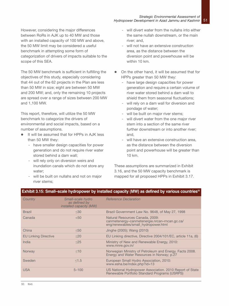
51Strategic Environmental Assessment of
Hydropower Development in Azad Jammu and Kashmir
However, considering the major differencesbetween RoRs in AJK up to 40 MW and thosewith an installed capacity of 100 MW and above,the 50 MW limit may be considered a usefulbenchmark in attempting some form ofcategorization of drivers of impacts suitable to thescope of this SEA.
The 50 MW benchmark is sufficient in fulfilling theobjectives of this study, especially consideringthat 44 out of the 62 projects in the Plan are lessthan 50 MW in size; eight are between 50 MWand 200 MW; and, only the remaining 10 projectsare spread over a range of sizes between 200 MWand 1,100 MW.
This report, therefore, will utilize the 50 MWbenchmark to categorize the drivers ofenvironmental and social impacts, based on anumber of assumptions.l It will be assumed that for HPPs in AJK less
than 50 MW they:- have smaller design capacities for power
generation and do not require river waterstored behind a dam wall;
- will rely only on diversion weirs andinundation canals which do not store anywater;
- will be built on nullahs and not on majorriver stems;
- will divert water from the nullahs into eitherthe same nullah downstream, or the mainriver; and,
- will not have an extensive constructionarea, as the distance between thediversion point and powerhouse will bewithin 10 km.
l On the other hand, it will be assumed that forHPPs greater than 50 MW they:- have large design capacities for power
generation and require a certain volume ofriver water stored behind a dam wall toshield them from seasonal fluctuations;
- will rely on a dam wall for diversion andpondage of water;
- will be built on major river stems;- will divert water from the one major river
stem into a section of the same riverfurther downstream or into another river;and,
- will have an extensive construction area,as the distance between the diversionpoint and powerhouse will be greater than10 km.
These assumptions are summarized in Exhibit3.16, and the 50 MW capacity benchmark ismapped for all proposed HPPs in Exhibit 3.17.
Country Small–scale hydro Reference Declarationas defined by
installed capacity (MW)
Brazil ≤30 Brazil Government Law No. 9648, of May 27, 1998
Canada <50 Natural Resources Canada, 2009: canmetenergy–canmetenergie.nrcan–rncan.gc.ca/eng/renewables/small_hydropower.html
China ≤50 Jinghe (2005); Wang (2010)
EU Linking Directive ≤20 EU Linking directive, Directive 2004/101/EC, article 11a, (6)
India ≤25 Ministry of New and Renewable Energy, 2010: www.mnre.gov.in/
Norway ≤10 Norwegian Ministry of Petroleum and Energy. Facts 2008. Energy and Water Resources in Norway; p.27
Sweden ≤1.5 European Small Hydro Association, 2010: www.esha.be/index.php?id=13
USA 5–100 US National Hydropower Association. 2010 Report of StateRenewable Portfolio Standard Programs (USRPS)
Exhibit 3.15: Small–scale hydropower by installed capacity (MW) as defined by various countries32
32. Ibid.
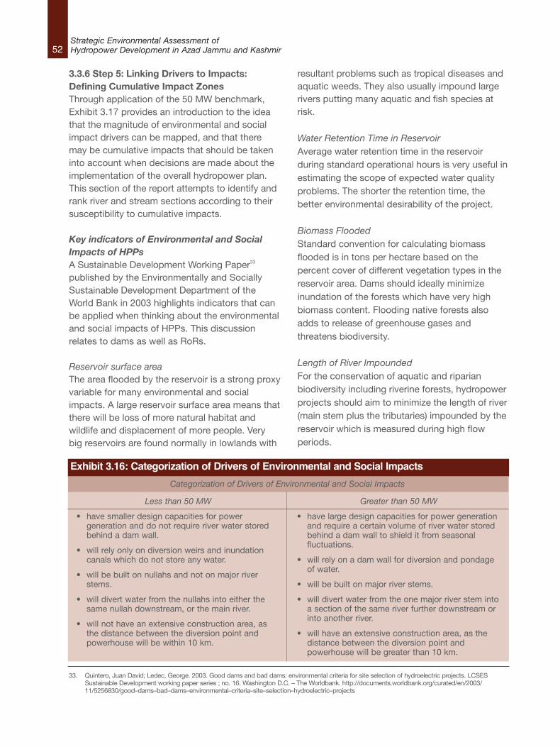
52Strategic Environmental Assessment ofHydropower Development in Azad Jammu and Kashmir
Exhibit 3.16: Categorization of Drivers of Environmental and Social Impacts
Categorization of Drivers of Environmental and Social Impacts
Less than 50 MW
• have smaller design capacities for powergeneration and do not require river water storedbehind a dam wall.
• will rely only on diversion weirs and inundationcanals which do not store any water.
• will be built on nullahs and not on major riverstems.
• will divert water from the nullahs into either thesame nullah downstream, or the main river.
• will not have an extensive construction area, asthe distance between the diversion point andpowerhouse will be within 10 km.
Greater than 50 MW
• have large design capacities for power generationand require a certain volume of river water storedbehind a dam wall to shield it from seasonalfluctuations.
• will rely on a dam wall for diversion and pondageof water.
• will be built on major river stems.
• will divert water from the one major river stem intoa section of the same river further downstream orinto another river.
• will have an extensive construction area, as thedistance between the diversion point andpowerhouse will be greater than 10 km.
3.3.6 Step 5: Linking Drivers to Impacts:Defining Cumulative Impact ZonesThrough application of the 50 MW benchmark,Exhibit 3.17 provides an introduction to the ideathat the magnitude of environmental and socialimpact drivers can be mapped, and that theremay be cumulative impacts that should be takeninto account when decisions are made about theimplementation of the overall hydropower plan.This section of the report attempts to identify andrank river and stream sections according to theirsusceptibility to cumulative impacts.
Key indicators of Environmental and SocialImpacts of HPPsA Sustainable Development Working Paper33
published by the Environmentally and SociallySustainable Development Department of theWorld Bank in 2003 highlights indicators that canbe applied when thinking about the environmentaland social impacts of HPPs. This discussionrelates to dams as well as RoRs.
Reservoir surface areaThe area flooded by the reservoir is a strong proxyvariable for many environmental and socialimpacts. A large reservoir surface area means thatthere will be loss of more natural habitat andwildlife and displacement of more people. Verybig reservoirs are found normally in lowlands with
resultant problems such as tropical diseases andaquatic weeds. They also usually impound largerivers putting many aquatic and fish species atrisk.
Water Retention Time in ReservoirAverage water retention time in the reservoirduring standard operational hours is very useful inestimating the scope of expected water qualityproblems. The shorter the retention time, thebetter environmental desirability of the project.
Biomass FloodedStandard convention for calculating biomassflooded is in tons per hectare based on thepercent cover of different vegetation types in thereservoir area. Dams should ideally minimizeinundation of the forests which have very highbiomass content. Flooding native forests alsoadds to release of greenhouse gases andthreatens biodiversity.
Length of River ImpoundedFor the conservation of aquatic and riparianbiodiversity including riverine forests, hydropowerprojects should aim to minimize the length of river(main stem plus the tributaries) impounded by thereservoir which is measured during high flowperiods.
33. Quintero, Juan David; Ledec, George. 2003. Good dams and bad dams: environmental criteria for site selection of hydroelectric projects. LCSESSustainable Development working paper series ; no. 16. Washington D.C. – The Worldbank. http://documents.worldbank.org/curated/en/2003/11/5256830/good–dams–bad–dams–environmental–criteria–site–selection–hydroelectric–projects
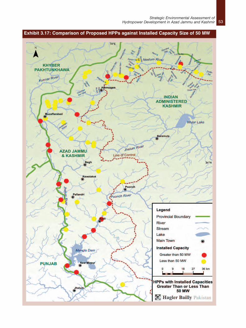
53Strategic Environmental Assessment of
Hydropower Development in Azad Jammu and Kashmir
Exhibit 3.17: Comparison of Proposed HPPs against Installed Capacity Size of 50 MW
54Strategic Environmental Assessment ofHydropower Development in Azad Jammu and Kashmir
Length of River Dried OutThis indicator measures the length in kilometersof the river which is left dry (with less than 50percent of dry season mean flow) below the damor diversion weir as a result of water diversion.This value should be minimized due to the loss offish and other aquatic life, damage to riparianecosystems, and disruption of human watersupplies and agricultural activities.
Number of Downriver TributariesThis indicator relates to the number of majorundammed tributaries downstream of the projectsite. A higher number of tributaries are desirablefor maintaining accessible habitat for migratoryfish, the natural flooding regime for riverineecosystems, and nutrient or sediment inputsneeded for the high biological activities of theestuaries.
Likelihood of Reservoir StratificationStratification in a reservoir takes place when theupper zone of the lake is thermally segmentedfrom the deeper zone; the latter becomingstagnant and lacking in dissolved oxygentherefore making the region unsuitable for mostaquatic life.
Reservoir lifeUseful reservoir life is the number of years beforethe dead storage of a reservoir is completelyfilled, when further sedimentation decreases thelive storage and inhibits power generation. Deadstorage refers to the part of the reservoir waterbeneath the level of the intakes for the damturbines; and the water above this intake isreferred to as live storage. Useful reservoir lifedepends on dead storage and river bornesediment loads. This indicator is useful indetermining relative sustainability of electricpower generation. This indicator normally variesfrom less than ten years before dead storage isfilled to potentially thousands of years. Reservoirswhich are deep and situated onlow–sediment–load rivers have the longest usefulreservoir lives.
Access Roads through ForestsWhere the risks of induced deforestation are high,project siting should minimize the kilometers ofrequired new or upgraded access roads passingthrough or near natural forests.Human ResettlementHydropower project location should ideally seekto minimize the number of people requiringresettlement from the land area affected by thereservoir and various civil works.
Effect on Critical Natural HabitatsThe number of sites and hectares of criticalnatural habitats that are expected to be lost dueto inundation, borrow pits or other componentsneed to be assessed. Critical natural habitatssuch as officially proposed protected areas, aswell as unprotected areas of known highimportance for biodiversity conservation need tobe taken into account. Some hydroelectricprojects imply very important conservationopportunities by providing a strong justification(sediment reduction) and financial resourcesneeded for protecting natural habitats in uppercatchment areas.
Fish Species Diversity and EndemismFish species diversity is the number of speciesknown from the project area, including the damand reservoir site, as well as the downstreamzone of project influence. Fish species endemismis the number of native species known only fromthe project area, or the river system where theproject is located, and nowhere else on Earth.Dams are environmentally less objectionable ifthey affect rivers with a naturally low diversity andendemism of native fish species. In general, large,lowland rivers in warm (tropical or subtropical)climates have a high diversity of native fish andother aquatic organisms, while small rivers in cold(tropical highland or temperate) climates haverelatively low diversity. Large, lowland rivers arealso more likely to have significant seasonal fishmigrations, which are effectively blocked by mostdams. However, highland rivers and streams oftenhave relatively high endemism in their fish fauna,
55Strategic Environmental Assessment of
Hydropower Development in Azad Jammu and Kashmir
especially if they are isolated from other rivers bywaterfalls or other natural barriers. Riversegments with threatened fish species foundnowhere else should be classified as criticalnatural habitats and, ideally, would receivepermanent protection from dams or otherpotentially damaging civil works. However, damsand reservoirs in upper tributary rivers andstreams need not threaten the survival of anyendemic fish (ormollusks, or other aquatic life) ifthey affect only an insignificant portion of the riverarea used by these species. They should also besited so as not to block important fish migrations.
Cultural Property AffectedAn indication of the cultural significance of thearea to be inundated (or otherwise affected by theproject) is the number (by type) of cultural(archaeological, historical, paleontological, orreligious) objects or sites. It is important to notewhether each type of cultural property at theproject site is salvageable (totally, partially, or notat all).
Indicators Relevant to the AJK HydropowerPlanBased on the criteria and assumptions forcategorizing drivers of impacts outlined in Section3.3.5 and the geographic, topographic,hydrological and socioeconomic context of AJK,the following indicators are considered to be themost relevant in predicting the environmental andsocial impacts from the development of the Plan:I. Length of river dried out.
II. Number of downriver tributaries.
III. Construction works and access roads throughforests.
IV. Human resettlement.
V. Fish habitat, effect on critical natural habitatsand fish species diversity and endemism.
VI. Reservoir size.
Exhibit 3.18 applies these indicators as criteria tocompare the environmental and social impactsthat might be expected from HPPs that are eitherbelow, or above, the 50 MW benchmark.
In the exhibit, the severity of possible impacts iscategorized using a colour scheme. Thecategorizations are based on the likelihood of theimpacts taking place, the magnitude of the effectand the scale of mitigation and monitoring thatmay be required. The description of thecategories is as follows:l Low (green):
- Likelihood of impact occurring is low;- If it takes place, the severity and
magnitude of the impact on riverineecology is small; and,
- There are minimal mitigation measuresrequired and no long–term monitoring.
l Medium (yellow):- Likelihood of impact occurring is high;- The severity and magnitude of the impact
on riverine ecology is high; and,- It will require some mitigation measures in
the design of the HPP but no monitoringrequired.
l High (red):- Likelihood of impact occurring is high;- The severity and magnitude of the impact
on riverine ecology and human settlementsis high
- Mitigation measures may includecompensation and resettlement of localsand regular monitoring of project during itslife.
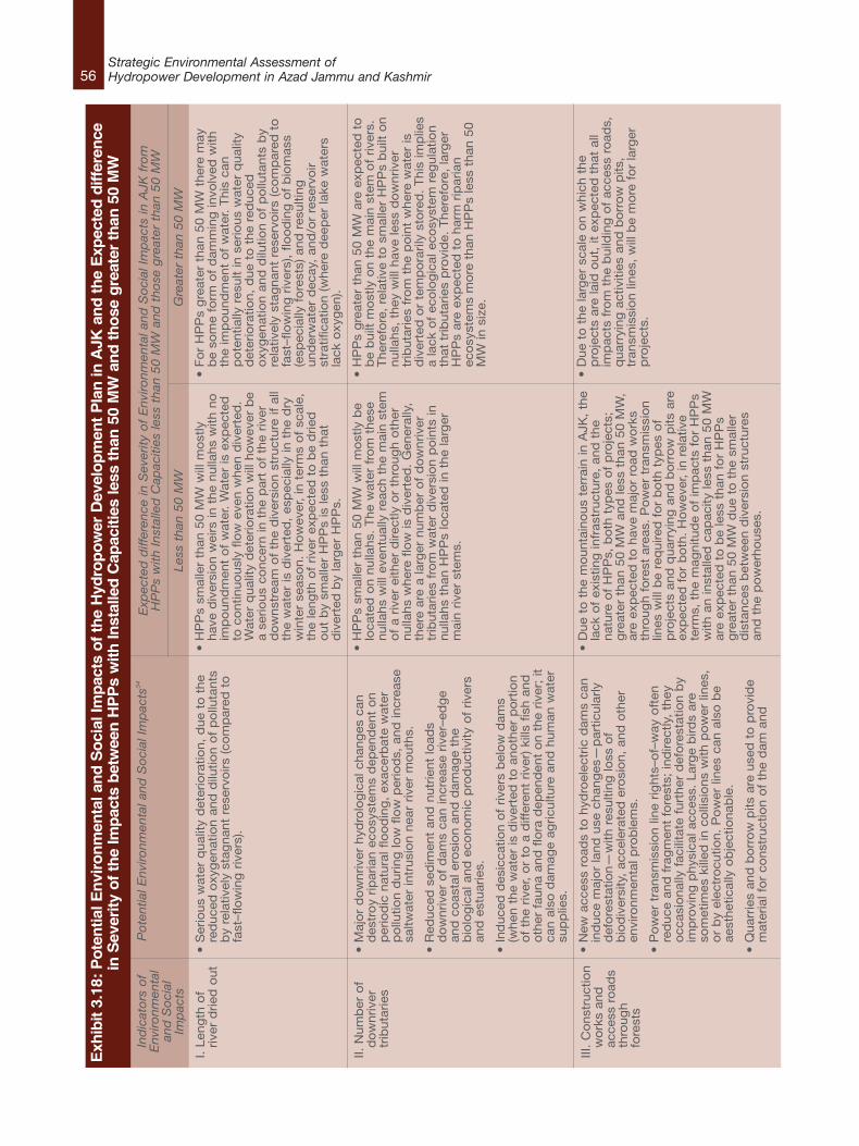
56Strategic Environmental Assessment ofHydropower Development in Azad Jammu and Kashmir
Exhibit 3.18: Potential Environmental and Social Impacts of the Hydropower Development Plan in AJK and the Expected difference
in Severity of the Impacts between HPPs with Installed Capacities less than 50 MW and those greater than 50 MW
Indicators of
Environm
ental
and Social
Impacts
I. Len
gth
of
river
drie
d o
ut
II. N
um
ber
of
do
wnriv
ertr
ibuta
ries
III.
Co
nst
ruct
ion
wo
rks
and
acce
ss r
oad
sth
roug
hfo
rest
s
Potential Environm
ental and
Social Impacts
34
•S
erio
us
wat
er q
ual
ity d
eter
iora
tion,
due
to t
he
red
uce
d o
xyg
enat
ion a
nd
dilu
tion o
f p
ollu
tants
by
rela
tivel
y st
agnan
t re
serv
oirs
(co
mp
ared
to
fast
–flo
win
g r
iver
s).
•M
ajo
r d
ow
nriv
er h
ydro
log
ical
chan
ges
can
des
tro
y rip
aria
n e
cosy
stem
s d
epen
den
t o
np
erio
dic
nat
ura
l flo
od
ing
, ex
acer
bat
e w
ater
po
llutio
n d
urin
g lo
w f
low
per
iod
s, a
nd
incr
ease
saltw
ater
intr
usi
on n
ear
river
mo
uth
s.
•R
educe
d s
edim
ent
and
nutr
ient
load
sd
ow
nriv
er o
f d
ams
can in
crea
se r
iver
–ed
ge
and
co
asta
l ero
sio
n a
nd
dam
age
the
bio
log
ical
and
eco
no
mic
pro
duct
ivity
of
river
san
d e
stuar
ies.
•In
duce
d d
esic
catio
n o
f riv
ers
bel
ow
dam
s(w
hen
the
wat
er is
div
erte
d t
o a
no
ther
po
rtio
no
f th
e riv
er,
or
to a
diff
eren
t riv
er)
kills
fis
h a
nd
oth
er f
auna
and
flo
ra d
epen
den
t o
n t
he
river
; it
can a
lso
dam
age
agric
ultu
re a
nd
hum
an w
ater
sup
plie
s.
•N
ew a
cces
s ro
ads
to h
ydro
elec
tric
dam
s ca
nin
duce
maj
or
land
use
chan
ges
—p
artic
ula
rlyd
efo
rest
atio
n—
with
res
ulti
ng
loss
of
bio
div
ersi
ty,
acce
lera
ted
ero
sio
n,
and
oth
eren
viro
nm
enta
l pro
ble
ms.
•P
ow
er t
ransm
issi
on li
ne
rights
–of–
way
oft
enre
duce
and
fra
gm
ent
fore
sts;
ind
irect
ly,
they
occ
asio
nal
ly f
acili
tate
furt
her
def
ore
stat
ion b
yim
pro
ving
phys
ical
acc
ess.
Lar
ge
bird
s ar
eso
met
imes
kill
ed in
co
llisi
ons
with
po
wer
lines
,o
r b
y el
ectr
ocu
tion.
Po
wer
lines
can
als
o b
eae
sthet
ical
ly o
bje
ctio
nab
le.
•Q
uar
ries
and
bo
rro
w p
its a
re u
sed
to
pro
vid
em
ater
ial f
or
const
ruct
ion o
f th
e d
am a
nd
Less than 50 M
W
•H
PP
s sm
alle
r th
an 5
0 M
W w
ill m
ost
lyhav
e d
iver
sio
n w
eirs
in t
he
nulla
hs
with
no
imp
ound
men
t o
f w
ater
. W
ater
is e
xpec
ted
to c
ontin
uo
usl
y flo
w e
ven w
hen
div
erte
d.
Wat
er q
ual
ity d
eter
iora
tion w
ill h
ow
ever
be
a se
rious
conce
rn in
the
par
t o
f th
e riv
erd
ow
nst
ream
of
the
div
ersi
on s
truct
ure
if a
llth
e w
ater
is d
iver
ted
, es
pec
ially
in t
he
dry
win
ter
seas
on.
Ho
wev
er,
in t
erm
s o
f sc
ale,
the
leng
th o
f riv
er e
xpec
ted
to
be
drie
do
ut
by
smal
ler
HP
Ps
is le
ss t
han
that
div
erte
d b
y la
rger
HP
Ps.
•H
PP
s sm
alle
r th
an 5
0 M
W w
ill m
ost
ly b
elo
cate
d o
n n
ulla
hs.
The
wat
er f
rom
thes
enulla
hs
will
eve
ntu
ally
rea
ch t
he
mai
n s
tem
of
a riv
er e
ither
dire
ctly
or
thro
ug
h o
ther
nulla
hs
wher
e flo
w is
div
erte
d.
Gen
eral
ly,
ther
e ar
e a
larg
er n
um
ber
of
do
wnriv
ertr
ibuta
ries
fro
m w
ater
div
ersi
on p
oin
ts in
nulla
hs
than
HP
Ps
loca
ted
in t
he
larg
erm
ain r
iver
ste
ms.
•D
ue
to t
he
mo
unta
ino
us
terr
ain in
AJK
, th
ela
ck o
f ex
istin
g in
fras
truct
ure
, an
d t
he
nat
ure
of
HP
Ps,
bo
th t
ypes
of
pro
ject
s;g
reat
er t
han
50 M
W a
nd
less
than
50 M
W,
are
exp
ecte
d t
o h
ave
maj
or
road
wo
rks
thro
ug
h f
ore
st a
reas
. P
ow
er t
ransm
issi
on
lines
will
be
req
uire
d f
or
bo
th t
ypes
of
pro
ject
s an
d q
uar
ryin
g a
nd
bo
rro
w p
its a
reex
pec
ted
fo
r b
oth
. H
ow
ever
, in
rel
ativ
ete
rms,
the
mag
nitu
de
of
imp
acts
fo
r H
PP
sw
ith a
n in
stal
led
cap
acity
less
than
50 M
War
e ex
pec
ted
to
be
less
than
fo
r H
PP
sg
reat
er t
han
50 M
W d
ue
to t
he
smal
ler
dis
tance
s b
etw
een d
iver
sio
n s
truct
ure
san
d t
he
po
wer
ho
use
s.
Expected difference in Severity of Environm
ental and
Social Impacts in AJK
from
HPPs with Installed Capacities less than 50 M
W and
those greater than 50 M
W
Greater than 50 M
W
•F
or
HP
Ps
gre
ater
than
50 M
W t
her
e m
ayb
e so
me
form
of
dam
min
g in
volv
ed w
ithth
e im
po
und
men
t o
f w
ater
. T
his
can
po
tentia
lly r
esult
in s
erio
us
wat
er q
ual
ityd
eter
iora
tion,
due
to t
he
red
uce
do
xyg
enat
ion a
nd
dilu
tion o
f p
ollu
tants
by
rela
tivel
y st
agnan
t re
serv
oirs
(co
mp
ared
to
fast
–flo
win
g r
iver
s),
floo
din
g o
f b
iom
ass
(esp
ecia
lly f
ore
sts)
and
res
ulti
ng
und
erw
ater
dec
ay,
and
/or
rese
rvo
irst
ratif
icat
ion (
wher
e d
eep
er la
ke w
ater
sla
ck o
xyg
en).
•H
PP
s g
reat
er t
han
50 M
W a
re e
xpec
ted
to
be
built
mo
stly
on t
he
mai
n s
tem
of
river
s.T
her
efo
re,
rela
tive
to s
mal
ler
HP
Ps
built
on
nulla
hs,
they
will
hav
e le
ss d
ow
nriv
ertr
ibuta
ries
fro
m t
he
po
int
wher
e w
ater
isd
iver
ted
or
tem
po
raril
y st
ore
d.
This
imp
lies
a la
ck o
f ec
olo
gic
al e
cosy
stem
reg
ula
tion
that
trib
uta
ries
pro
vid
e. T
her
efo
re,
larg
erH
PP
s ar
e ex
pec
ted
to
har
m r
ipar
ian
eco
syst
ems
mo
re t
han
HP
Ps
less
than
50
MW
in s
ize.
•D
ue
to t
he
larg
er s
cale
on w
hic
h t
he
pro
ject
s ar
e la
id o
ut,
it e
xpec
ted
that
all
imp
acts
fro
m t
he
build
ing
of
acce
ss r
oad
s,q
uar
ryin
g a
ctiv
ities
and
bo
rro
w p
its,
tran
smis
sio
n li
nes
, w
ill b
e m
ore
fo
r la
rger
pro
ject
s.
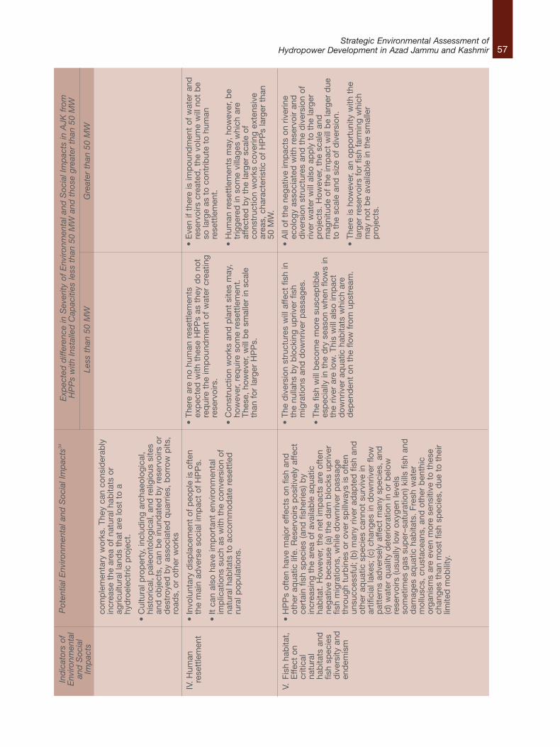
57Strategic Environmental Assessment of
Hydropower Development in Azad Jammu and KashmirIndicators of
Environm
ental
and Social
Impacts
IV.
Hum
anre
sett
lem
ent
V.Fi
sh h
abita
t,E
ffect
on
criti
cal
natu
ral
hab
itats
and
fish
spec
ies
div
ersi
ty a
nden
dem
ism
Potential Environm
ental and
Social Impacts
34
com
ple
men
tary
wor
ks.
They
can
con
sid
erab
lyin
crea
se t
he a
rea
of n
atur
al h
abita
ts o
rag
ricul
tura
l lan
ds
that
are
lost
to
ahy
dro
elec
tric
pro
ject
.
•C
ultu
ral p
rop
erty
, in
clud
ing
arch
aeol
ogic
al,
hist
oric
al,
pal
eont
olog
ical
, an
d r
elig
ious
site
san
d o
bje
cts,
can
be
inun
dat
ed b
y re
serv
oirs
or
des
troy
ed b
y as
soci
ated
qua
rrie
s, b
orro
w p
its,
road
s, o
r ot
her
wor
ks
•In
volu
ntar
y d
isp
lace
men
t of
peo
ple
is o
ften
the
mai
n ad
vers
e so
cial
imp
act
of H
PP
s.
•It
can
also
hav
e im
por
tant
env
ironm
enta
lim
plic
atio
ns s
uch
as w
ith t
he c
onve
rsio
n of
natu
ral h
abita
ts t
o ac
com
mod
ate
rese
ttle
dru
ral p
opul
atio
ns.
•H
PP
s of
ten
have
maj
or e
ffect
s on
fis
h an
dot
her
aqua
tic li
fe.
Res
ervo
irs p
ositi
vely
affe
ctce
rtai
n fis
h sp
ecie
s (a
nd f
ishe
ries)
by
incr
easi
ng t
he a
rea
of a
vaila
ble
aq
uatic
hab
itat.
How
ever
, th
e ne
t im
pac
ts a
re o
ften
nega
tive
bec
ause
(a) t
he d
am b
lock
s up
river
fish
mig
ratio
ns,
whi
le d
ownr
iver
pas
sage
thro
ugh
turb
ines
or
over
sp
illw
ays
is o
ften
unsu
cces
sful
; (b
) man
y riv
er a
dap
ted
fis
h an
dot
her
aqua
tic s
pec
ies
cann
ot s
urvi
ve in
artif
icia
l lak
es;
(c) c
hang
es in
dow
nriv
er f
low
pat
tern
s ad
vers
ely
affe
ct m
any
spec
ies,
and
(d) w
ater
qua
lity
det
erio
ratio
n in
or
bel
owre
serv
oirs
(usu
ally
low
oxy
gen
leve
lsso
met
imes
gas
sup
er–s
atur
atio
n) k
ills
fish
and
dam
ages
aq
uatic
hab
itats
. Fr
esh
wat
erm
ollu
scs,
cru
stac
eans
, an
d o
ther
ben
thic
orga
nism
s ar
e ev
en m
ore
sens
itive
to
thes
ech
ange
s th
an m
ost
fish
spec
ies,
due
to
thei
rlim
ited
mob
ility
.
Less than 50 M
W
•Th
ere
are
no h
uman
res
ettle
men
tsex
pec
ted
with
the
se H
PP
s as
the
y d
o no
tre
qui
re t
he im
pou
ndm
ent
of w
ater
cre
atin
gre
serv
oirs
.
•C
onst
ruct
ion
wor
ks a
nd p
lant
site
s m
ay,
how
ever
, re
qui
re s
ome
rese
ttle
men
t.Th
ese,
how
ever
, w
ill b
e sm
alle
r in
sca
leth
an f
or la
rger
HP
Ps.
•Th
e d
iver
sion
str
uctu
res
will
affe
ct f
ish
inth
e nu
llahs
by
blo
ckin
g up
river
fis
hm
igra
tions
and
dow
nriv
er p
assa
ges.
•Th
e fis
h w
ill b
ecom
e m
ore
susc
eptib
lees
pec
ially
in t
he d
ry s
easo
n w
hen
flow
s in
the
river
are
low
. Th
is w
ill a
lso
imp
act
dow
nriv
er a
qua
tic h
abita
ts w
hich
are
dep
end
ent
on t
he f
low
fro
m u
pst
ream
.
Expected difference in Severity of Environm
ental and
Social Impacts in AJK
from
HPPs with Installed Capacities less than 50 M
W and
those greater than 50 M
W
Greater than 50 M
W
•E
ven
if th
ere
is im
pou
ndm
ent
of w
ater
and
rese
rvoi
rs c
reat
ed,
the
volu
me
will
not
be
so la
rge
as t
o co
ntrib
ute
to h
uman
rese
ttle
men
t.
•H
uman
res
ettle
men
ts m
ay,
how
ever
, b
etr
igge
red
in s
ome
villa
ges
whi
ch a
reaf
fect
ed b
y th
e la
rger
sca
le o
fco
nstr
uctio
n w
orks
cov
erin
g ex
tens
ive
area
s, c
hara
cter
istic
of
HP
Ps
larg
er t
han
50 M
W.
•A
ll of
the
neg
ativ
e im
pac
ts o
n riv
erin
eec
olog
y as
soci
ated
with
res
ervo
ir an
dd
iver
sion
str
uctu
res
and
the
div
ersi
on o
friv
er w
ater
will
als
o ap
ply
to
the
larg
erp
roje
cts.
How
ever
, th
e sc
ale
and
mag
nitu
de
of t
he im
pac
t w
ill b
e la
rger
due
to t
he s
cale
and
siz
e of
div
ersi
on.
•Th
ere
is h
owev
er,
an o
pp
ortu
nity
with
the
larg
er r
eser
voirs
for
fis
h fa
rmin
g w
hich
may
not
be
avai
lab
le in
the
sm
alle
rp
roje
cts.

58Strategic Environmental Assessment ofHydropower Development in Azad Jammu and Kashmir
Indicators of
Environmental
and Social
Impacts
VI.
Res
ervo
irsi
ze
Potential Environmental and Social Impacts
34
•F
loo
din
g o
f b
iom
ass
(esp
ecia
lly f
ore
sts)
an
dre
sulti
ng
un
der
wat
er d
ecay
, an
d/o
r re
serv
oir
stra
tific
atio
n (
wh
ere
dee
per
lake
wat
ers
lack
oxy
gen
).
•S
om
e re
serv
oirs
per
man
ently
flo
od
ext
ensi
ven
atu
ral h
abita
ts,
with
loca
l an
d e
ven
glo
bal
extin
ctio
ns
of
anim
al a
nd
pla
nt
spec
ies.
Par
ticu
larly
har
d–h
it ar
e rive
rin
e fo
rest
s an
do
ther
rip
aria
n e
co s
yste
ms,
wh
ich
nat
ura
llyo
ccu
r o
nly
alo
ng
riv
ers
and
str
eam
s.
•T
he
loss
of
terr
estr
ial w
ildlif
e to
dro
wn
ing
du
rin
g r
eser
voir f
illin
g is
an
inh
eren
tco
nse
qu
ence
of
the
floo
din
g o
f te
rres
tria
ln
atu
ral h
abita
ts.
So
me
infe
ctio
us
dis
ease
sca
n s
pre
ad a
rou
nd
hyd
roel
ectr
ic r
eser
voirs,
par
ticu
larly
in w
arm
clim
ates
an
d d
ense
lyp
op
ula
ted
are
as.
So
me
dis
ease
s (s
uch
as
mal
aria
an
d s
chis
toso
mia
sis)
are
bo
rne
by
wat
er–d
epen
den
t d
isea
se v
ecto
rs(m
osq
uito
es a
nd
aq
uat
ic s
nai
ls);
oth
ers
(su
chas
dys
ente
ry,
cho
lera
, an
d h
epat
itis
A)
are
spre
ad b
y co
nta
min
ated
wat
er,
wh
ich
freq
uen
tly b
eco
mes
wo
rse
in s
tag
nan
tre
serv
oirs
than
it w
as in
fas
t–flo
win
g r
iver
s.
•F
loat
ing
aq
uat
ic v
eget
atio
n c
an r
apid
lyp
rolif
erat
e in
eu
tro
ph
ic r
eser
voirs
cau
sin
gp
rob
lem
s su
ch a
s (a
) d
egra
ded
hab
itat
for
mo
st s
pec
ies
of
fish
an
d o
ther
aq
uat
ic li
fe,
(b)
imp
rove
d b
reed
ing
gro
un
ds
for
mo
squ
itoes
and
oth
er n
uis
ance
sp
ecie
s an
d d
isea
seve
cto
rs,
(c)
imp
eded
nav
igat
ion
an
dsw
imm
ing
, (d
) cl
og
gin
g o
f el
ectr
o–m
ech
anic
aleq
uip
men
t at
dam
s, a
nd
(e)
incr
ease
d w
ater
loss
fro
m s
om
e re
serv
oirs.
•G
reen
ho
use
gas
es (
carb
on
dio
xid
e an
dm
eth
ane)
are
rel
ease
d in
to t
he
atm
osp
her
efr
om
res
ervo
irs
that
flo
od
fo
rest
s an
d o
ther
bio
mas
s, e
ither
slo
wly
(as
flo
od
ed o
rgan
icm
atte
r d
eco
mp
ose
s) o
r ra
pid
ly (
if th
e fo
rest
iscu
t an
d b
urn
ed b
efo
re r
eser
voir f
illin
g)
•O
ver
time,
live
sto
rage
and
pow
er g
ener
atio
n ar
ere
duc
ed b
y re
serv
oir
sed
imen
tatio
n, s
uch
that
muc
h of so
me
pro
ject
s’ h
ydro
elec
tric
ene
rgy
mig
ht n
ot
be
rene
wab
le o
ver
the
long
ter
m
Less than 50 M
W
•It
will
be
un
likel
y th
at t
her
e w
ill b
e an
yre
serv
oirs
in t
hes
e p
roje
cts.
Expected difference in Severity of Environmental and Social Impacts in AJK
from
HPPs with Installed Capacities less than 50 M
W and those greater than 50 M
W
Greater than 50 M
W
•R
eser
voir s
izes
may
be
larg
e an
d m
ay r
isk
floo
din
g p
arts
of
rive
rin
e fo
rest
s al
on
g t
he
rive
rs.
•T
he
pro
ble
ms
asso
ciat
ed w
ith lo
ng
erw
ater
ret
entio
n t
imes
may
be
rele
van
t fo
rla
rger
Ro
R p
roje
cts.
34.
Q
uint
ero,
Jua
n D
avid
; Le
dec
, G
eorg
e. 2
003.
Goo
d d
ams
and
bad
dam
s: e
nviro
nmen
tal c
riter
ia f
or s
ite s
elec
tion
of h
ydro
elec
tric
pro
ject
s. L
CS
ES
Sus
tain
able
Dev
elop
men
t w
orki
ng p
aper
ser
ies
; no
. 16
.W
ashi
ngto
n D
.C.
– Th
e W
orld
ban
k. h
ttp
://d
ocum
ents
.wor
ldb
ank.
org/
cura
ted
/en/
2003
/11/
5256
830/
good
–dam
s–b
ad–d
ams–
envi
ronm
enta
l–cr
iteria
–site
–sel
ectio
n–hy
dro
elec
tric
–pro
ject
s
59Strategic Environmental Assessment of
Hydropower Development in Azad Jammu and Kashmir
3.3.7 Step 5: Potential CumulativeEnvironmental and Social Impacts from AJK’sHydropower Development PlanIn previous sections, both the drivers of theenvironmental and social impacts, and theimpacts themselves have been analyzed, takinginto account individual HPPs of different sizes.However, aquatic biodiversity in rivers does notexist in isolation in different stretches of rivers, butas an integrated process across the basin. Whenthe process is disrupted by a diversion structuresuch as a dam, weir, canal or tunnel, it hasbasin–wide impacts. The development of anumber of HPPs on the same river basins andsystems will result in cumulative environmentaland social impacts. One large–scale hydropowerproject of 2,000 MW located in a remote area ofone river basin might have fewer negative impactsthan the cumulative impacts of 400 5 MWhydropower projects in many river basins.35
In the context of hydropower development,cumulative impacts can result from (i) multipleactions at a given site associated with a singleproject, or (ii) can be additive or synergistic36 innature when potential impacts of multiple damsare taken into account and are concentrated intime or space, for example, the impacts of aseries of small dams constructed on a singlestream or on streams within a single river basin.37
Such impacts may occur when the affectedsystem is being perturbed repeatedly andincreasingly by the same local agent withsufficient frequency so that it does not have timeto recover between events (time–crowding), or theaffected system is being perturbed by severalsimilar activities or different activities havingsimilar effects, in an area too small to assimilatethe combined impacts (space–crowding).38
A strong correlation exists between stream flowand a river’s physico–chemical characteristics
such as water temperature and habitat diversity.Changes in flow volume and patterns canadversely impact the structure, distribution andcomposition of fish communities in the region.Dams, or any construction across rivers, arealways a barrier for fish which move from one partof stream or river to another as part of their lifecycle processes. Changes in the sedimentationflows due to dam or barrier construction,especially in Himalayan rivers, are expected tohave an adverse impact on fish habitats. Even afew centimeters of sediment layer over the naturalsubstrata is enough to affect the foraging andspawning fish negatively. Changes in theabundance of fish species found in AJK riversmay affect income generated by locals fromcommercial fishing activities and from touristsattracted by game–fishing in the State.
In this section, different cumulative impacts arediscussed based on the different drivers ofimpacts of HPPs in the Plan and the nature andmagnitude of the impacts. In the process, riversections which are most vulnerable to cumulativeimpacts will be identified as impact zones and willthen be superimposed on the environmentally andsocially sensitive river sections of AJK to beidentified in Section 3.3.8 and Section 3.3.9.
Exhibit 3.19 describes the mechanics of howcumulative impacts from the construction andoperation of HPPs may affect differentenvironmental and social components. Potentiallyaffected components include the following:l Habitats and Wildlife
- Flora species- Fish species- Amphibians- Reptiles- Birds- Mammals
35. Egre, D., Milewski, J.C. (2002). The diversity of hydropower projects, Energy Policy, Vol. 30, No. 14, Nov. 2002, pp 1225–1230.Synergistic or interactive effects are generally the result of interactions between effects of two or more projects that result in combined effectsthat are greater than the sum of the individual project’s effects and typically more complex and difficult to assess than additive effects.
36. Arikan, Esra; Dieterle, Gerhard; Bouzaher, Aziz; Ceribasi, Ibrahim Haluk; Kaya, Dundar Emre; Nishimura, Shinya; Karamullaoglu, Ulker;Kahraman, Bilgen. 2012. Sample guidelines : cumulative environmental impact assessment for hydropower projects in Turkey. Washington DC; World Bank.http://documents.worldbank.org/curated/en/2012/12/17671936/sample–guidelines–cumulative–environmental–impact–assessment–hydropower–projects–turkey
37. Rajvanshi, Asha; Roshni Arora; Vinod B. Mathur; K. Sivakumar; S. Sathyakumar; G.S. Rawat; J.A. Johnson; K. Ramesh; NandKishor Dimri andAjay Maletha (2012) Assessment of Cumulative Impacts of Hydroelectric Projects on Aquatic and Terrestrial Biodiversity in Alaknanda andBhagirathi Basins, Uttarakhand. Wildlife Institute of India, Technical Report. Pp 203 plus Appendices.
38. Ibid.
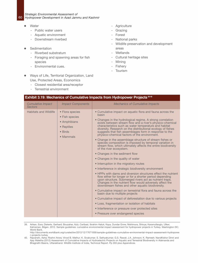
60Strategic Environmental Assessment ofHydropower Development in Azad Jammu and Kashmir
l Water- Public water users- Aquatic environment- Downstream riverbed
l Sedimentation- Riverbed substratum- Foraging and spawning areas for fish
species- Environmental cues.
l Ways of Life, Territorial Organization, LandUse, Protected Areas, Economics- Closest residential area/receptor- Terrestrial environment
- Agriculture- Grazing- Forest- National parks- Wildlife preservation and development
areas- Wetlands- Cultural heritage sites- Mining- Fishery- Tourism
Cumulative ImpactSectors
Habitats and Wildlife
Impact Components
• Flora species
• Fish species
• Amphibians
• Reptiles
• Birds
• Mammals
Mechanics of Cumulative Impacts
• Cumulative impact on aquatic flora and fauna across thebasin
• Changes in the hydrological regime. A strong correlationexists between stream flow and a river’s physico–chemicalcharacteristics such as water temperature and habitatdiversity. Research on the distributional ecology of fishessuggests that fish assemblages form in response to thephysico–chemical factors of the environment.
• Change in the assemblage structure of stream fishes orspecies composition is imposed by temporal variation instream flow, which ultimately affects the entire biodiversityof the river ecosystem.
• Changes in the sediment flow
• Changes in the quality of water
• Interruption in the migratory routes
• Interference in strategic biodiversity environment
• HPPs with dams and diversion structures effect the nutrientflow either for longer or for a shorter period dependingupon structure. Submerged rivers act as nutrient traps.Changes in the nutrient flow would adversely affect thedownstream fishes and other aquatic biodiversity.
• Cumulative impact on terrestrial flora and fauna across thebasin due to multiple projects
• Cumulative impact of deforestation due to various projects
• Loss, fragmentation or isolation of habitats
• Interference or pressure over protected sites
• Pressure over endangered species
39. Arikan, Esra; Dieterle, Gerhard; Bouzaher, Aziz; Ceribasi, Ibrahim Haluk; Kaya, Dundar Emre; Nishimura, Shinya; Karamullaoglu, Ulker;Kahraman, Bilgen. 2012. Sample guidelines: cumulative environmental impact assessment for hydropower projects in Turkey. Washington DC;World Bank.http://documents.worldbank.org/curated/en/2012/12/17671936/sample–guidelines–cumulative–environmental–impact–assessment–hydropower–projects–turkey
40. Rajvanshi, Asha; Roshni Arora; Vinod B. Mathur; K. Sivakumar; S. Sathyakumar; G.S. Rawat; J.A. Johnson; K. Ramesh; NandKishor Dimri andAjay Maletha (2012) Assessment of Cumulative Impacts of Hydroelectric Projects on Aquatic and Terrestrial Biodiversity in Alaknanda andBhagirathi Basins, Uttarakhand. Wildlife Institute of India, Technical Report. Pp 203 plus Appendices.
Exhibit 3.19: Mechanics of Cumulative Impacts from Hydropower Projects39 40

61Strategic Environmental Assessment of
Hydropower Development in Azad Jammu and Kashmir
Cumulative ImpactSectors
Water
Sedimentation
Ways of Life
Territorial Organization
Land Use
Protected Areas
Economics
Impact Components
• Public water users
• Aquatic environment
• Downstream riverbed
• Riverbed substratum
• Foraging andspawning areas forfish species
• Environmental cues.
• Closest residentialarea/receptor
• Terrestrialenvironment
• Agriculture
• Grazing
• Forest
• National parks
• Wildlife preservationand developmentareas
• Wetlands
• Cultural heritage sites
• Mining
• Fishery
• Tourism
Mechanics of Cumulative Impacts
• Impact of differential water flow downstream from powerhouse in dry season months, with sudden release of heavyflows during peaking/ power generation hours and noreleases during other times.
• Opportunity for the multiple uses of water
• Cumulative impact on hydrological flows, at various pointswithin project, at various points within a day, season, year,over the years and cumulatively across the basin andimpacts thereof.
• This will include impacts on various hydrological elementsincluding springs, tributaries, groundwater aquifers andthus access to drinking water and irrigation
• Changes in sedimentation at various points within project,at various points within a day, season, year, over the yearsand cumulatively across the basin and impacts thereof.
• Release of silt free water into the river downstream fromthe power house and impact thereof on thegeomorphology, erosion, stability of structures.
• Release of silt laden water into the river channeldownstream from the dam, and its accumulation across thedry season.
• Cumulative impact of all the project components (dam,tunnels, blasting, power house, muck dumping, mining,road building, township building, deforestation,transmission lines, etc)
• Cumulative impact of mining of various materials requiredfor the projects (sand, boulders, coarse and fine granules,etc.)
• Cumulative impact of blasting of tunnels on variousaspects
• Cumulative impact of muck dumping into rivers.
• Road Infrastructure Improvements.
• Pressure over the ways of life due to people attracted tothe area of the project
• Changes in the way of life of people depending of the riverenvironmental services
• Epidemiological changes
• Loss of archaeological, historic and cultural patrimony
• Increase of conflicts
• Local Labour Market dinamization;
• Interference in the territorial organization of local people
• Interference in the flow of people, goods and services
• Loss of municipalities’ territory
• Pressure over sociocultural relationships
• Pressure over ecological conditions of indigenous area.
• Loss of areas with economic productivity
• Loss of resources (mining, fishery, touristy, agricultural,among others)
• Local Government Revenues Increase;
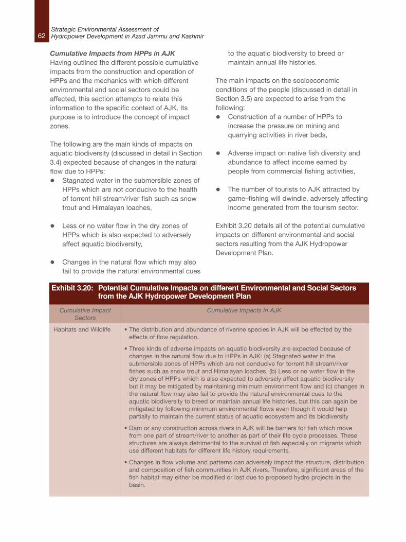
62Strategic Environmental Assessment ofHydropower Development in Azad Jammu and Kashmir
Cumulative Impacts from HPPs in AJKHaving outlined the different possible cumulativeimpacts from the construction and operation ofHPPs and the mechanics with which differentenvironmental and social sectors could beaffected, this section attempts to relate thisinformation to the specific context of AJK. Itspurpose is to introduce the concept of impactzones.
The following are the main kinds of impacts onaquatic biodiversity (discussed in detail in Section3.4) expected because of changes in the naturalflow due to HPPs:l Stagnated water in the submersible zones of
HPPs which are not conducive to the healthof torrent hill stream/river fish such as snowtrout and Himalayan loaches,
l Less or no water flow in the dry zones ofHPPs which is also expected to adverselyaffect aquatic biodiversity,
l Changes in the natural flow which may alsofail to provide the natural environmental cues
to the aquatic biodiversity to breed ormaintain annual life histories.
The main impacts on the socioeconomicconditions of the people (discussed in detail inSection 3.5) are expected to arise from thefollowing:l Construction of a number of HPPs to
increase the pressure on mining andquarrying activities in river beds,
l Adverse impact on native fish diversity andabundance to affect income earned bypeople from commercial fishing activities,
l The number of tourists to AJK attracted bygame–fishing will dwindle, adversely affectingincome generated from the tourism sector.
Exhibit 3.20 details all of the potential cumulativeimpacts on different environmental and socialsectors resulting from the AJK HydropowerDevelopment Plan.
Cumulative ImpactSectors
Habitats and Wildlife
Cumulative Impacts in AJK
• The distribution and abundance of riverine species in AJK will be effected by theeffects of flow regulation.
• Three kinds of adverse impacts on aquatic biodiversity are expected because ofchanges in the natural flow due to HPPs in AJK: (a) Stagnated water in thesubmersible zones of HPPs which are not conducive for torrent hill stream/riverfishes such as snow trout and Himalayan loaches, (b) Less or no water flow in thedry zones of HPPs which is also expected to adversely affect aquatic biodiversitybut it may be mitigated by maintaining minimum environment flow and (c) changes inthe natural flow may also fail to provide the natural environmental cues to theaquatic biodiversity to breed or maintain annual life histories, but this can again bemitigated by following minimum environmental flows even though it would helppartially to maintain the current status of aquatic ecosystem and its biodiversity
• Dam or any construction across rivers in AJK will be barriers for fish which movefrom one part of stream/river to another as part of their life cycle processes. Thesestructures are always detrimental to the survival of fish especially on migrants whichuse different habitats for different life history requirements.
• Changes in flow volume and patterns can adversely impact the structure, distributionand composition of fish communities in AJK rivers. Therefore, significant areas of thefish habitat may either be modified or lost due to proposed hydro projects in thebasin.
Exhibit 3.20: Potential Cumulative Impacts on different Environmental and Social Sectors from the AJK Hydropower Development Plan
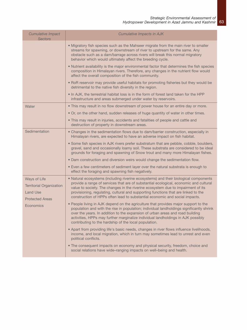
63Strategic Environmental Assessment of
Hydropower Development in Azad Jammu and Kashmir
Cumulative ImpactSectors
Water
Sedimentation
Ways of Life
Territorial Organization
Land Use
Protected Areas
Economics
Cumulative Impacts in AJK
• Migratory fish species such as the Mahseer migrate from the main river to smallerstreams for spawning, or downstream of river to upstream for the same. Anyobstacle such as a dam/barrage across rivers will break this normal migratorybehavior which would ultimately affect the breeding cycle.
• Nutrient availability is the major environmental factor that determines the fish speciescomposition in Himalayan rivers. Therefore, any changes in the nutrient flow wouldaffect the overall composition of the fish community.
• RoR reservoir may provide useful habitats for promoting fisheries but they would bedetrimental to the native fish diversity in the region.
• In AJK, the terrestrial habitat loss is in the form of forest land taken for the HPPinfrastructure and areas submerged under water by reservoirs.
• This may result in no flow downstream of power house for an entire day or more.
• Or, on the other hand, sudden releases of huge quantity of water in other times.
• This may result in injuries, accidents and fatalities of people and cattle anddestruction of property in downstream areas.
• Changes in the sedimentation flows due to dam/barrier construction, especially inHimalayan rivers, are expected to have an adverse impact on fish habitat.
• Some fish species in AJK rivers prefer substratum that are pebble, cobble, boulders,gravel, sand and occasionally loamy soil. These substrata are considered to be idealgrounds for foraging and spawning of Snow trout and many more Himalayan fishes.
• Dam construction and diversion weirs would change the sedimentation flow.
• Even a few centimeters of sediment layer over the natural substrata is enough toeffect the foraging and spawning fish negatively.
• Natural ecosystems (including riverine ecosystems) and their biological componentsprovide a range of services that are of substantial ecological, economic and culturalvalue to society. The changes in the riverine ecosystem due to impairment of itsprovisioning, regulating, cultural and supporting functions that are linked to theconstruction of HPPs often lead to substantial economic and social impacts.
• People living in AJK depend on the agriculture that provides major support to thepopulation and with the rise in population; individual landholdings significantly shrinkover the years. In addition to the expansion of urban areas and road buildingactivities, HPPs may further marginalize individual landholdings in AJK possiblycontributing to the hardship of the local population.
• Apart from providing life's basic needs, changes in river flows influence livelihoods,income, and local migration, which in turn may sometimes lead to unrest and evenpolitical conflicts.
• The consequent impacts on economy and physical security, freedom, choice andsocial relations have wide–ranging impacts on well–being and health.
64Strategic Environmental Assessment ofHydropower Development in Azad Jammu and Kashmir
Identifying Cumulative Impact Zones
Based on the geographical locations and
potential cumulative impacts expected from
hydropower development in AJK, river and stream
sections across the State that may be prone to
the cumulative impacts of HPP development can
be delineated into impact zones.
The cumulative impacts relevant to AJK and
outlined in Exhibit 3.20 reveal that the nature and
magnitude of the potential impacts are linked
strongly to the rivers and streams themselves.
The extent of potential environmental and social
impacts, in terms of geographical area, is also
limited to areas close to them. This is due to the
topography of AJK, where rivers flow through
narrow valleys with steep and high slopes on both
sides. Therefore, in terms of the lateral extent of
impacts, these are not expected to carry the
effect of any cumulative environmental or social
impact beyond 500 m from the center of the river
on both sides. The main rivers of the AJK are the
Neelum, Jhelum and Poonch rivers. HPPs not
located on these are assumed to be located on
the nullahs or streams that are tributaries of the
main rivers.
Therefore, the delineation of impact zones is
centered on the nullahs and the main stems of the
rivers where the HPPs will be located. The nullahs
and river sections will be split based on a
continuous stretch up to a confluence point where
another nullah or river intersects.
For illustrative purposes, the width of the impact
zone on each side of the river is kept at 1.5 km.
The lengths of the zones, however, are governed
by the effect of RoRs on nullahs and main stems
of rivers, not only at the points where diversion
structures are located, but also on stretches
located downriver. Hence, the longer boundary of
the impact zones along the river takes into
account the cumulative impacts of the
development of a number of HPPs in close
proximity on the same river systems.
Based on the predicted extent and severity of the
cumulative impacts, the impact zones will be
categorized into Moderately Critical Zones, Highly
Critical Zones and Extremely Critical Zones.
Extent of Cumulative Impact
The extent of cumulative impact will be
categorized in terms of their location on a nullah
or the main stem of a river, and the number of
other HPPs located on that same section.
l Nullahs or main river stems — in terms of the
length of river dried out and the number of
downstream tributaries available to absorb
upstream ecological disturbances, nullahs are
considered better locations for HPPs than
main river stems. Therefore, if a particular
zone is located on a nullah it scores ‘1’, while
those on a main river stem score ‘2’. The
impact zones on main river stems and nullahs
are shown in Exhibit 3.21.
l The number of HPPs — knowing the extent
of a river section affected by the diversion of
water by specific HPPs would be the most
useful indicator of the extent of cumulative
impacts. However, the exact locations of the
HPPs in the Plan are not available.
Considering the scope of this report, the
number of HPPs being planned in a particular
zone is an adequate substitute to indicate the
extent of impact. Zones with one HPP in
them score ‘1’, while zones with more than
one HPP located on them score ‘2’.
The scoring system is used to indicate the extent
of cumulative impact. In Exhibit 3.22 the location
of an impact zone is designated as being either
‘restricted’, ‘medium’ or ‘wide’. The extent of
cumulative impact is expressed graphically in
Exhibit 3.23.
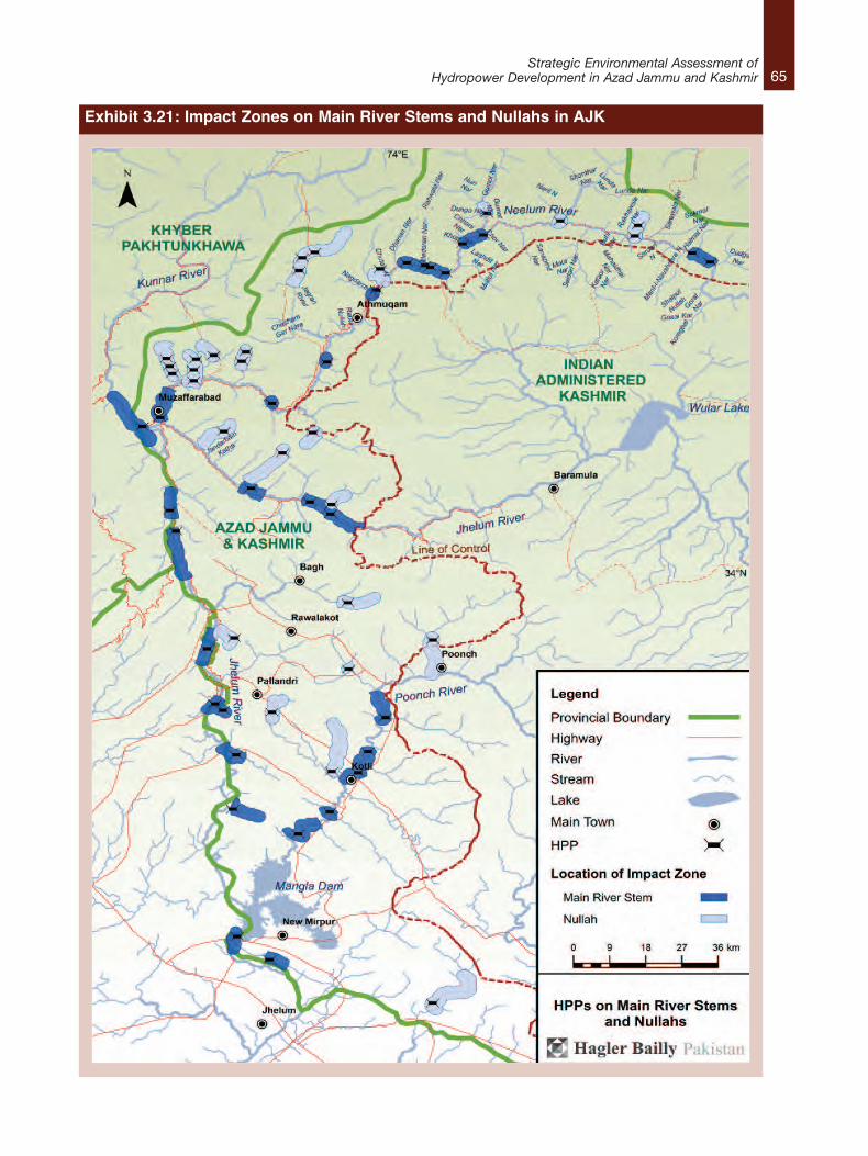
65Strategic Environmental Assessment of
Hydropower Development in Azad Jammu and Kashmir
Exhibit 3.21: Impact Zones on Main River Stems and Nullahs in AJK

66Strategic Environmental Assessment ofHydropower Development in Azad Jammu and Kashmir
Extent of Number of HPPs in a given zoneCumulative Impacts (Total Score) One More than one
(score = 1) (score = 2)
Location of impact zone Nullah (score = 1) Restricted (2) Medium (3)
Main stem Medium (3) Wide (4)of river (score = 2)
Exhibit 3.22: Matrix indicating the Extent of Cumulative Impacts as ‘Restricted’,‘Medium’ and ‘Wide’
Exhibit 3.23: Extent of Cumulative Impacts on Nullahs and Main River Stems from HPPs in AJK
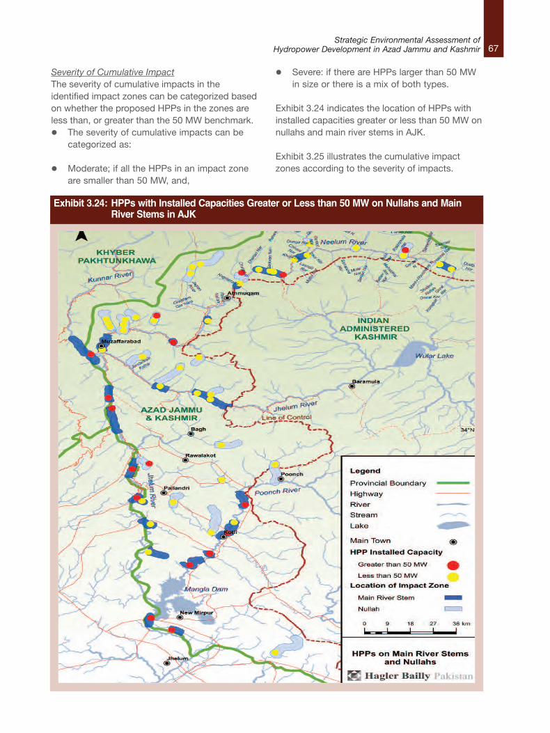
67Strategic Environmental Assessment of
Hydropower Development in Azad Jammu and Kashmir
Severity of Cumulative ImpactThe severity of cumulative impacts in theidentified impact zones can be categorized basedon whether the proposed HPPs in the zones areless than, or greater than the 50 MW benchmark.l The severity of cumulative impacts can be
categorized as:
l Moderate; if all the HPPs in an impact zoneare smaller than 50 MW, and,
l Severe: if there are HPPs larger than 50 MWin size or there is a mix of both types.
Exhibit 3.24 indicates the location of HPPs withinstalled capacities greater or less than 50 MW onnullahs and main river stems in AJK.
Exhibit 3.25 illustrates the cumulative impactzones according to the severity of impacts.
Exhibit 3.24: HPPs with Installed Capacities Greater or Less than 50 MW on Nullahs and Main River Stems in AJK
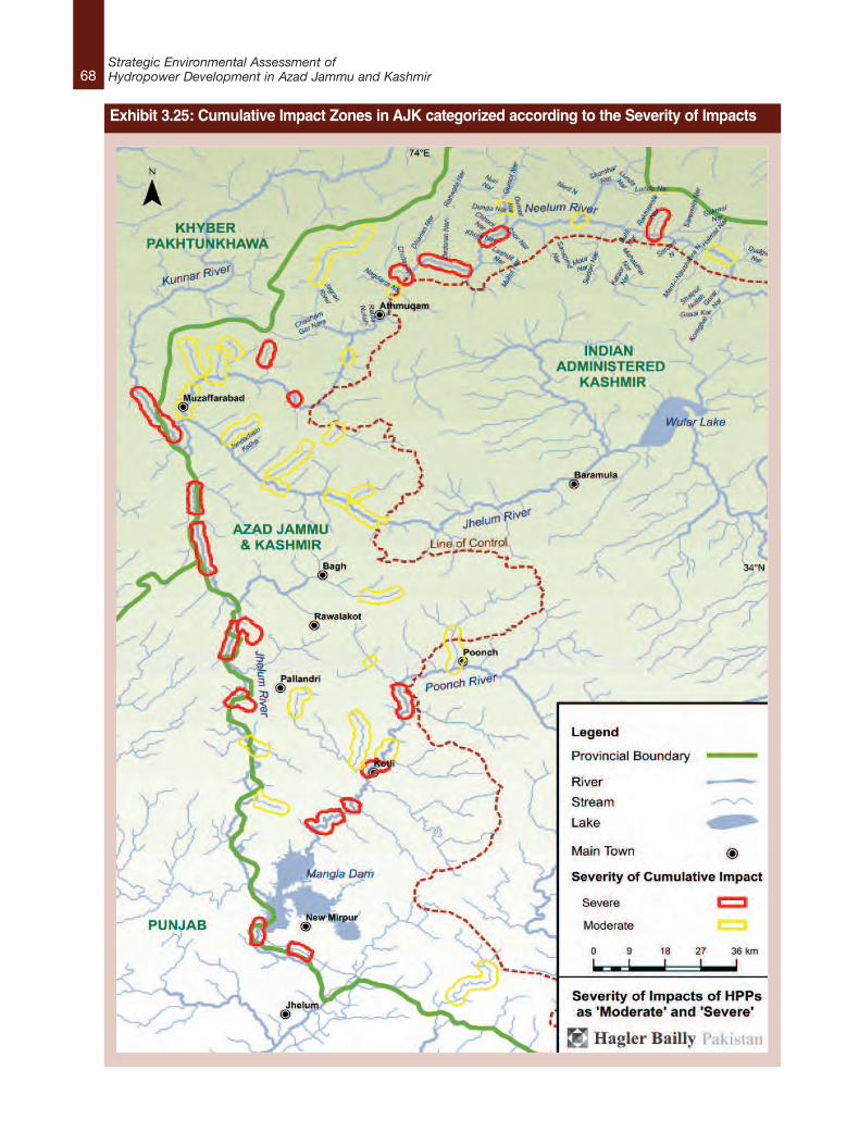
68Strategic Environmental Assessment ofHydropower Development in Azad Jammu and Kashmir
Exhibit 3.25: Cumulative Impact Zones in AJK categorized according to the Severity of Impacts
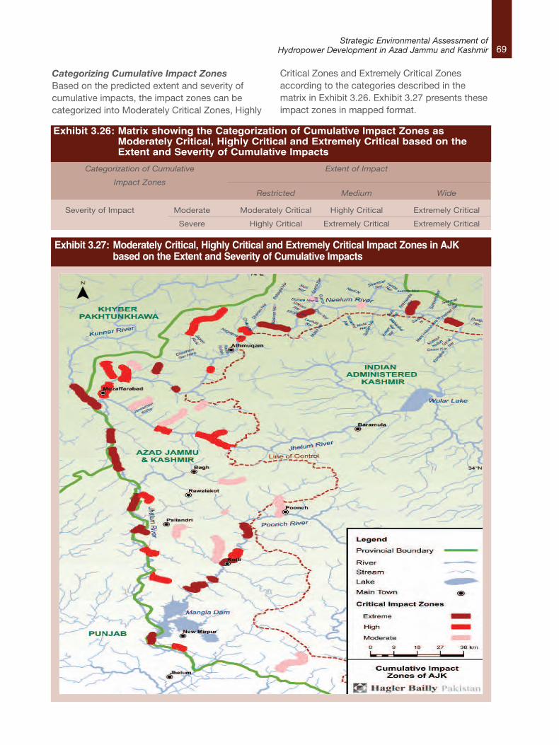
69Strategic Environmental Assessment of
Hydropower Development in Azad Jammu and Kashmir
Categorizing Cumulative Impact ZonesBased on the predicted extent and severity ofcumulative impacts, the impact zones can becategorized into Moderately Critical Zones, Highly
Critical Zones and Extremely Critical Zonesaccording to the categories described in thematrix in Exhibit 3.26. Exhibit 3.27 presents theseimpact zones in mapped format.
Categorization of Cumulative Extent of Impact
Impact ZonesRestricted Medium Wide
Severity of Impact Moderate Moderately Critical Highly Critical Extremely Critical
Severe Highly Critical Extremely Critical Extremely Critical
Exhibit 3.26: Matrix showing the Categorization of Cumulative Impact Zones asModerately Critical, Highly Critical and Extremely Critical based on the Extent and Severity of Cumulative Impacts
Exhibit 3.27: Moderately Critical, Highly Critical and Extremely Critical Impact Zones in AJK based on the Extent and Severity of Cumulative Impacts
70Strategic Environmental Assessment ofHydropower Development in Azad Jammu and Kashmir
ConclusionThe extent of the river system in AJK which will beaffected by the development of HPPs in thehydropower plan can be seen from Exhibit 2.27.All of the main stems of the rivers of AJK are hostto Extremely, Highly and Moderately CriticalImpact Zones. On the nullahs, the CumulativeImpact Zones are mostly only highly ormoderately critical.
It must be remembered that the results of thecategorization of the nature of the CumulativeImpact Zones in AJK are—to a degree—arbitrary.The categorization was based on the severity andextent of the cumulative impacts using qualitativepredictive methods such as the matrices inExhibit 3.22 and Exhibit 3.26. In turn, these werebased on a brief analysis of the design features ofHPPs, and on a limited amount of primaryscientific data.
For a fully rigorous study of cumulative impacts, itwould be necessary to examine the structuralfeatures and components of all the HPPs in thePlan in greater detail. Such a study would lookinto the exact volumes of water diverted, theremaining downstream flows, the extent of thediversion, the exact volume of plannedimpoundment of water, the size of theconstruction works, and the extent and locationsof development of new infrastructure associatedwith each project.
The objective of this report is to assist the AJKauthorities identify the scale, diversity, magnitudeand complexity of the potential cumulativeenvironmental and social impacts emanating fromthe development of the Plan, and to identify theareas and river sections most sensitive to thoseimpacts. The report also aims to provide theauthorities with a guide to help direct the focus offurther detailed EIA studies that may need to beundertaken as part of the design of specificprojects. The identification of the critical impactzones in Exhibit 3.27 adequately serves thepurpose by providing approximate locations ofthe areas expected to be affected and thepossible severity of impacts.
What remains now is to examine the condition ofenvironmental and social ‘baselines’ on rivers ornullahs that are likely to be developed. TheCumulative Impact Zones identified in Exhibit 3.27can then be superimposed on these baselines,and the areas in AJK most prone to cumulativeimpacts from the development of the Plan willfinally be identified.
3.4 Step 6: Environmental Baseline3.4.1 IntroductionThis section focuses on the aquatic and terrestrialecological resources of AJK. A considerableamount of background information on rivercharacteristics, aquatic flora and fauna, terrestrialflora, mammals, birds, reptiles, and protectedareas is included in Appendix B of this report. Aliterature review of research articles, previous EIA(Environmental Impact Assessment) reports,relevant books and websites was carried out togather this information.
For the purposes of this SEA pilot study, thecondition of the environmental baseline in relevantrivers and streams is represented by fish. Theyare the most easily studied aquatic organisms(compared to algal flora and macro–invertebrates),sensitive to physical and chemical variations inthe water as well as to changes in river flows andvolumes. They are therefore vulnerable tochanges caused by the construction andoperation of HPPs. Fish fauna are therefore usedas an indicator of river biodiversity for thepurpose of ecological zoning in this report.41 Thesources used to identify fish ecology in the riversof AJK in this report are listed in Exhibit 3.28.
Based on ecological contiguity, this report dividesthe rivers of AJK into nine zones. The features ofthese river zones as well as the ecologicalresources they contain are discussed in detail inSection 3.4.2. The ecological sensitivity of eachriver zone is assessed and discussed followed bya determination of the sensitivity of river sectionsto the development of HPPs (Section 3.4.3).
41. Mirza, M. R. (1994). Geographical distribution of freshwater fishes in Pakistan: a review. Punjab Univ. J. Zool., 9: 93–108.
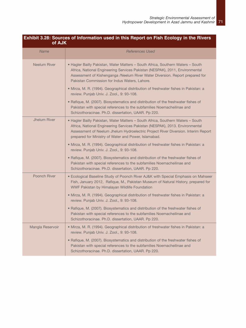
71Strategic Environmental Assessment of
Hydropower Development in Azad Jammu and Kashmir
Name
Neelum River
Jhelum River
Poonch River
Mangla Reservoir
References Used
• Hagler Bailly Pakistan, Water Matters – South Africa, Southern Waters – SouthAfrica, National Engineering Services Pakistan (NESPAK), 2011, EnvironmentalAssessment of Kishenganga /Neelum River Water Diversion. Report prepared forPakistan Commission for Indus Waters, Lahore.
• Mirza, M. R. (1994). Geographical distribution of freshwater fishes in Pakistan: areview. Punjab Univ. J. Zool., 9: 93-108.
• Rafique, M. (2007). Biosystematics and distribution of the freshwater fishes ofPakistan with special references to the subfamilies Noemacheilinae andSchizothoracinae. Ph.D. dissertation, UAAR. Pp 220.
• Hagler Bailly Pakistan, Water Matters – South Africa, Southern Waters – SouthAfrica, National Engineering Services Pakistan (NESPAK), 2013. EnvironmentalAssessment of Neelum Jhelum Hydroelectric Project River Diversion. Interim Reportprepared for Ministry of Water and Power, Islamabad.
• Mirza, M. R. (1994). Geographical distribution of freshwater fishes in Pakistan: areview. Punjab Univ. J. Zool., 9: 93-108.
• Rafique, M. (2007). Biosystematics and distribution of the freshwater fishes ofPakistan with special references to the subfamilies Noemacheilinae andSchizothoracinae. Ph.D. dissertation, UAAR. Pp 220.
• Ecological Baseline Study of Poonch River AJ&K with Special Emphasis on MahseerFish, January 2012, Rafique, M., Pakistan Museum of Natural History, prepared forWWF Pakistan by Himalayan Wildlife Foundation
• Mirza, M. R. (1994). Geographical distribution of freshwater fishes in Pakistan: areview. Punjab Univ. J. Zool., 9: 93-108.
• Rafique, M. (2007). Biosystematics and distribution of the freshwater fishes ofPakistan with special references to the subfamilies Noemacheilinae andSchizothoracinae. Ph.D. dissertation, UAAR. Pp 220.
Exhibit 3.28: Sources of Information used in this Report on Fish Ecology in the Rivers of AJK
72Strategic Environmental Assessment ofHydropower Development in Azad Jammu and Kashmir
3.4.2 Ecological Zoning of AJK RiversFish abundance and diversity is dependent on thenature of the water habitat, water temperature,water quality, conditions of the river–bed, as wellas climatic conditions. Thus the physical andchemical characteristics of a water body have adirect relationship with the type of fish that will befound. Based on similarities in physical andchemical characteristics as well as the diversity offish fauna, the rivers of AJK have been dividedinto nine ecological zones. These zones areshown on a map in Exhibit 3.29: l Zone A – Neelum River from Taobat to
Dudhnial
l Zone B – Neelum River from Dudhnial toNauseri
l Zone C – Neelum River from Nauseri toMuzaffarabad
l Zone D – Jhelum River upstream Domel
l Zone E – Jhelum River Downstream Domel
l Zone F – Jhelum River at and below theConfluence of Mahl Nullah
l Zone G – Poonch River and Tributaries
l Zone H – Mangla Reservoir
l Zone I – Downstream Mangla Reservoir
The physical and biological characteristics ofeach zone are discussed below. A list of the fishspecies reported from each zone is given in asummary table. The fish species that have aconservation status or that are known to beeconomically important have been flagged in redcolour. This is followed by a discussion in which
the ecological importance and sensitivity of eachzone is assessed using the following indicators.
l Fish Diversity – This refers to the type andnumber of fish species reported. Greater fishdiversity is indicative of conditions conducivefor fish feeding, breeding and growth.42
l Conservation Status of Species – These mayinclude species that are listed in the IUCNRed List 201343 or those that are endemic toAJK44.
l Status as Protected Area – A protected areais a clearly defined geographical space,recognized, dedicated and managed, throughlegal or other effective means, to achieve thelong term conservation of nature withassociated ecosystem services and culturalvalues.45 Protected areas may include wildlifesanctuaries or national parks declared by thelocal government. Also included areprotected areas declared by IUCN ProtectedAreas Management46 and those that contain acritical habitat as designated by theInternational Finance Corporation (IFC)Performance Standards.47
l Economic Value of Fish – Fishing not onlyprovides food for local consumption but isalso a source of livelihood for individualsinvolved in commercial fishing as well as forindividuals working in the food industry (suchas processing and packaging of edible fishspecies). Fish are also important forrecreational and sport fishing and boosttourism.
l Besides, the above indicators, some riverecosystems are important because theyprovide a breeding ground, or migratory route
42. Rafique, M. (2007). Biosystematics and distribution of the freshwater fishes of Pakistan with special references to the subfamilies Noemacheilinae andSchizothoracinae. Ph.D. dissertation, UAAR. Pp 220.
43. The IUCN Red List of Threatened Species™ provides taxonomic, conservation status and distribution information on plants and animals that have beenglobally evaluated using the IUCN Red List Categories and Criteria. This system is designed to determine the relative risk of extinction, and the mainpurpose of the IUCN Red List is to catalogue and highlight those plants and animals that are facing a higher risk of global extinction (i.e. those listed asCritically Endangered, Endangered and Vulnerable). The IUCN Red List also includes information on plants and animals that are categorized as Extinct orExtinct in the Wild; on taxa that cannot be evaluated because of insufficient information (i.e., are Data Deficient); and on plants and animals that are eitherclose to meeting the threatened thresholds or that would be threatened were it not for an ongoing taxon–specific conservation programme (i.e., are NearThreatened).
44. Endemism is the ecological state of being unique to a defined geographic location, such as an island, country or other defined zone, or habitat type. 45. Dudley, N. (ed.) (2008) Guidelines for Appling Protected Areas Management Categories. IUCN: Gland, Switzerland.46. IUCN protected area management categories classify protected areas according to their management objectives. The categories are recognised by
international bodies such as the United Nations and by many national governments as the global standard for defining and recording protected areas andas such are increasingly being incorporated into government legislation. Available at official website of IUCN:http://www.iucn.org/about/work/programmes/gpap_home/gpap_quality/gpap_pacategories/ accessed on 16 September 2012.
47. Policy on Social and Environmental Sustainability, January 2012. Performance Standard 6: Biodiversity Conservation and Sustainable Management ofLiving Natural Resources, International Finance Corporation. The World Bank Group.
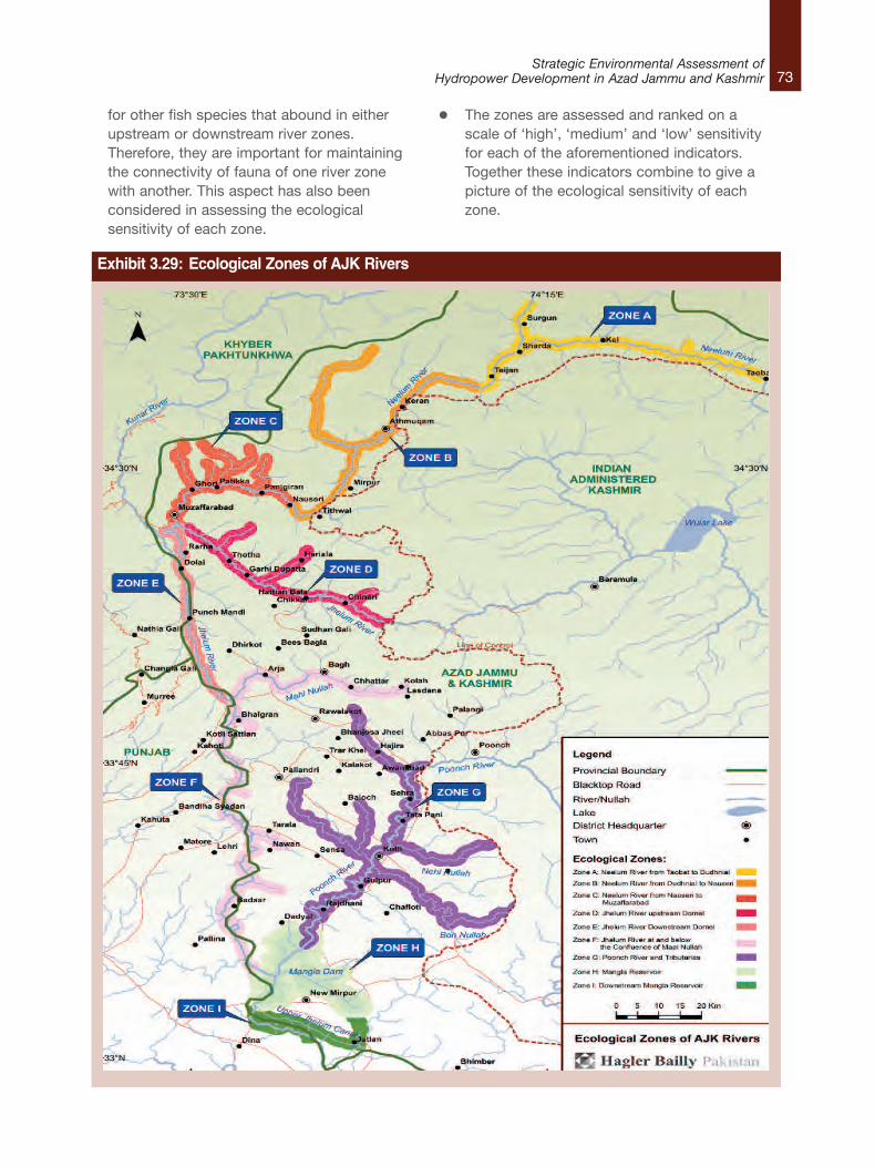
73Strategic Environmental Assessment of
Hydropower Development in Azad Jammu and Kashmir
Exhibit 3.29: Ecological Zones of AJK Rivers
for other fish species that abound in eitherupstream or downstream river zones.Therefore, they are important for maintainingthe connectivity of fauna of one river zonewith another. This aspect has also beenconsidered in assessing the ecologicalsensitivity of each zone.
l The zones are assessed and ranked on ascale of ‘high’, ‘medium’ and ‘low’ sensitivityfor each of the aforementioned indicators.Together these indicators combine to give apicture of the ecological sensitivity of eachzone.
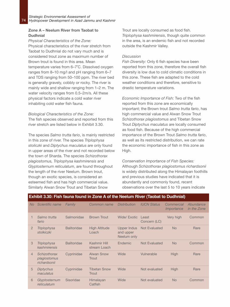
74Strategic Environmental Assessment ofHydropower Development in Azad Jammu and Kashmir
Zone A – Neelum River from Taobat toDudhnialPhysical Characteristics of the Zone: Physical characteristics of the river stretch fromTaobat to Dudhnial do not vary much and isconsidered trout zone as maximum number ofBrown trout is found in this area. Meantemperature varies from 6–7˚C. Dissolved oxygenranges from 8–10 mg/l and pH ranging from 6–7and TDS ranging from 50–100 ppm. The river bedis generally gravely, cobbly or rocky. The river ismainly wide and shallow ranging from 1–2 m. Thewater velocity ranges from 0.5–2m/s. All thesephysical factors indicate a cold water riverinhabiting cold water fish fauna.
Biological Characteristics of the Zone:The fish species observed and reported from thisriver stretch are listed below in Exhibit 3.30.
The species Salmo trutta fario, is mainly restrictedin this zone of river. The species Triplophysastoliczki and Diptychus maculatus are only foundin upper areas of the river and not recorded belowthe town of Sharda. The species Schizothoraxplagiostomus, Triplophysa kashmirensis andGlyptosternum reticulatum, are found throughoutthe length of the river Neelum. Brown trout,though an exotic species, is considered anesteemed fish and has high commercial value.Similarly Alwan Snow Trout and Tibetan Snow
Trout are locally consumed as food fish.Triplophysa kashmirensis, though quite commonin the area, is an endemic fish and not recordedoutside the Kashmir Valley.
DiscussionFish Diversity: Only 6 fish species have beenreported from this zone, therefore the overall fishdiversity is low due to cold climatic conditions inthis zone. These fish are adapted to the coldweather conditions and therefore, sensitive todrastic temperature variations.
Economic Importance of Fish: Two of the fishreported from this zone are economicallyimportant; the Brown trout Salmo trutta fario, hashigh commercial value and Alwan Snow TroutSchizothorax plagiostomus and Tibetan SnowTrout Diptychus maculatus are locally consumedas food fish. Because of the high commercialimportance of the Brown Trout Salmo trutta fario,as well as its restricted distribution, we can ratethe economic importance of fish in this zone asHigh.
Conservation Importance of Fish Species:Although Schizothorax plagiostomus richardsoniiis widely distributed along the Himalayan foothillsand previous studies have indicated that it isabundantly and commonly found, recentobservations over the last 5 to 10 years indicate
No
1
2
3
4
5
6
Scientific name
Salmo truttafario
Triplophysastolkiczki
Triplophysakashmirensis
Schizothoraxplagiostomusrichardsonii
Diptychusmaculatus
Glyptosternumreticulatum
Family
Salmonidae
Balitoridae
Balitoridae
Cyprinidae
Cyprinidae
Sisoridae
Common name
Brown Trout
High AltitudeLoach
Kashmir Hillstream Loach
Alwan SnowTrout
Tibetan SnowTrout
HimalayanCatfish
Distribution
Wide/ Exotic
Upper Indusand upperNeelum only
Endemic
Wide
Wide
Wide
IUCN Status
LeastConcern (LC)
Not Evaluated
Not Evaluated
Vulnerable
Not evaluated
Not evaluated
CommercialImportance
Very high
No
No
High
High
No
Abundancein the Zone
Common
Rare
Common
Rare
Rare
Common
Exhibit 3.30: Fish fauna found in Zone A of the Neelum River (Taobat to Dudhnial)
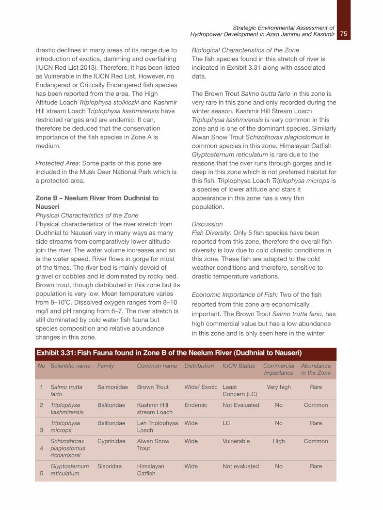
75Strategic Environmental Assessment of
Hydropower Development in Azad Jammu and Kashmir
drastic declines in many areas of its range due tointroduction of exotics, damming and overfishing(IUCN Red List 2013). Therefore, it has been listedas Vulnerable in the IUCN Red List. However, noEndangered or Critically Endangered fish specieshas been reported from the area. The HighAltitude Loach Triplophysa stolkiczki and KashmirHill stream Loach Triplophysa kashmirensis haverestricted ranges and are endemic. It can,therefore be deduced that the conservationimportance of the fish species in Zone A ismedium.
Protected Area: Some parts of this zone areincluded in the Musk Deer National Park which isa protected area.
Zone B – Neelum River from Dudhnial toNauseriPhysical Characteristics of the ZonePhysical characteristics of the river stretch fromDudhnial to Nauseri vary in many ways as manyside streams from comparatively lower altitudejoin the river. The water volume increases and sois the water speed. River flows in gorge for mostof the times. The river bed is mainly devoid ofgravel or cobbles and is dominated by rocky bed.Brown trout, though distributed in this zone but itspopulation is very low. Mean temperature variesfrom 8–10˚C. Dissolved oxygen ranges from 8–10mg/l and pH ranging from 6–7. The river stretch isstill dominated by cold water fish fauna butspecies composition and relative abundancechanges in this zone.
Biological Characteristics of the ZoneThe fish species found in this stretch of river isindicated in Exhibit 3.31 along with associateddata.
The Brown Trout Salmo trutta fario in this zone isvery rare in this zone and only recorded during thewinter season. Kashmir Hill Stream LoachTriplophysa kashmirensis is very common in thiszone and is one of the dominant species. SimilarlyAlwan Snow Trout Schizothorax plagiostomus iscommon species in this zone. Himalayan CatfishGlyptosternum reticulatum is rare due to thereasons that the river runs through gorges and isdeep in this zone which is not preferred habitat forthis fish. Triplophysa Loach Triplophysa microps isa species of lower altitude and stars itappearance in this zone has a very thinpopulation.
DiscussionFish Diversity: Only 5 fish species have beenreported from this zone, therefore the overall fishdiversity is low due to cold climatic conditions inthis zone. These fish are adapted to the coldweather conditions and therefore, sensitive todrastic temperature variations.
Economic Importance of Fish: Two of the fish
reported from this zone are economically
important. The Brown Trout Salmo trutta fario, has
high commercial value but has a low abundance
in this zone and is only seen here in the winter
No
1
2
3
4
5
Scientific name
Salmo truttafario
Triplophysakashmirensis
Triplophysamicrops
Schizothoraxplagiostomusrichardsonii
Glyptosternumreticulatum
Family
Salmonidae
Balitoridae
Balitoridae
Cyprinidae
Sisoridae
Common name
Brown Trout
Kashmir Hillstream Loach
Leh TriplophysaLoach
Alwan SnowTrout
HimalayanCatfish
Distribution
Wide/ Exotic
Endemic
Wide
Wide
Wide
IUCN Status
LeastConcern (LC)
Not Evaluated
LC
Vulnerable
Not evaluated
CommercialImportance
Very high
No
No
High
No
Abundancein the Zone
Rare
Common
Rare
Common
Rare
Exhibit 3.31:Fish Fauna found in Zone B of the Neelum River (Dudhnial to Nauseri)
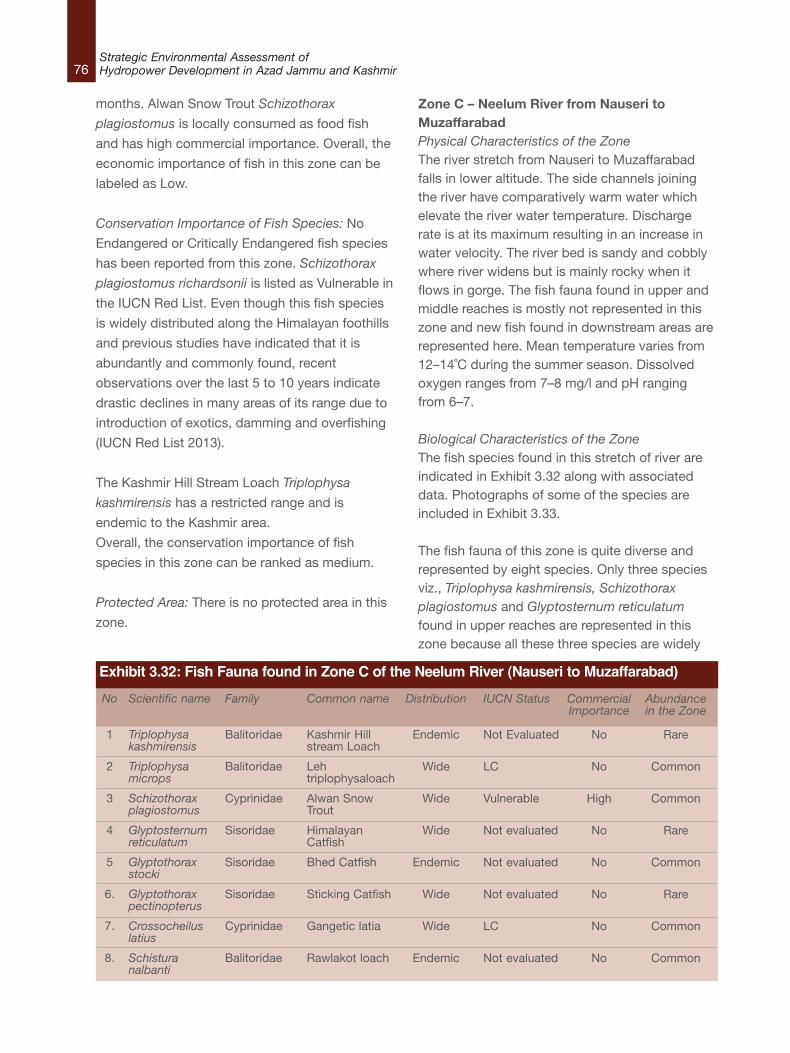
76Strategic Environmental Assessment ofHydropower Development in Azad Jammu and Kashmir
months. Alwan Snow Trout Schizothorax
plagiostomus is locally consumed as food fish
and has high commercial importance. Overall, the
economic importance of fish in this zone can be
labeled as Low.
Conservation Importance of Fish Species: No
Endangered or Critically Endangered fish species
has been reported from this zone. Schizothorax
plagiostomus richardsonii is listed as Vulnerable in
the IUCN Red List. Even though this fish species
is widely distributed along the Himalayan foothills
and previous studies have indicated that it is
abundantly and commonly found, recent
observations over the last 5 to 10 years indicate
drastic declines in many areas of its range due to
introduction of exotics, damming and overfishing
(IUCN Red List 2013).
The Kashmir Hill Stream Loach Triplophysa
kashmirensis has a restricted range and is
endemic to the Kashmir area.
Overall, the conservation importance of fish
species in this zone can be ranked as medium.
Protected Area: There is no protected area in this
zone.
Zone C – Neelum River from Nauseri toMuzaffarabad Physical Characteristics of the Zone The river stretch from Nauseri to Muzaffarabadfalls in lower altitude. The side channels joiningthe river have comparatively warm water whichelevate the river water temperature. Dischargerate is at its maximum resulting in an increase inwater velocity. The river bed is sandy and cobblywhere river widens but is mainly rocky when itflows in gorge. The fish fauna found in upper andmiddle reaches is mostly not represented in thiszone and new fish found in downstream areas arerepresented here. Mean temperature varies from12–14˚C during the summer season. Dissolvedoxygen ranges from 7–8 mg/l and pH rangingfrom 6–7.
Biological Characteristics of the ZoneThe fish species found in this stretch of river areindicated in Exhibit 3.32 along with associateddata. Photographs of some of the species areincluded in Exhibit 3.33.
The fish fauna of this zone is quite diverse andrepresented by eight species. Only three speciesviz., Triplophysa kashmirensis, Schizothoraxplagiostomus and Glyptosternum reticulatumfound in upper reaches are represented in thiszone because all these three species are widely
No
1
2
3
4
5
6.
7.
8.
Scientific name
Triplophysakashmirensis
Triplophysamicrops
Schizothoraxplagiostomus
Glyptosternumreticulatum
Glyptothoraxstocki
Glyptothoraxpectinopterus
Crossocheiluslatius
Schisturanalbanti
Family
Balitoridae
Balitoridae
Cyprinidae
Sisoridae
Sisoridae
Sisoridae
Cyprinidae
Balitoridae
Common name
Kashmir Hillstream Loach
Lehtriplophysaloach
Alwan SnowTrout
HimalayanCatfish
Bhed Catfish
Sticking Catfish
Gangetic latia
Rawlakot loach
Distribution
Endemic
Wide
Wide
Wide
Endemic
Wide
Wide
Endemic
IUCN Status
Not Evaluated
LC
Vulnerable
Not evaluated
Not evaluated
Not evaluated
LC
Not evaluated
CommercialImportance
No
No
High
No
No
No
No
No
Abundancein the Zone
Rare
Common
Common
Rare
Common
Rare
Common
Common
Exhibit 3.32: Fish Fauna found in Zone C of the Neelum River (Nauseri to Muzaffarabad)
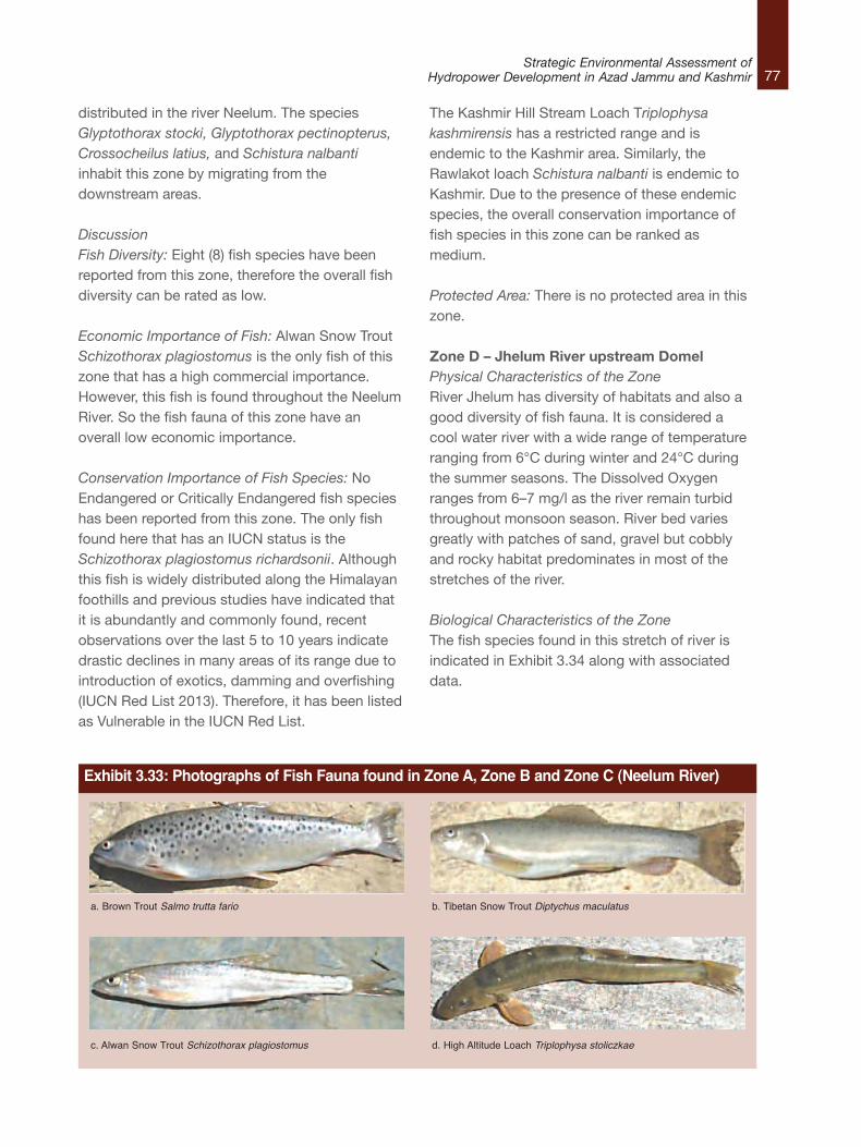
77Strategic Environmental Assessment of
Hydropower Development in Azad Jammu and Kashmir
distributed in the river Neelum. The speciesGlyptothorax stocki, Glyptothorax pectinopterus,Crossocheilus latius, and Schistura nalbantiinhabit this zone by migrating from thedownstream areas.
DiscussionFish Diversity: Eight (8) fish species have beenreported from this zone, therefore the overall fishdiversity can be rated as low.
Economic Importance of Fish: Alwan Snow TroutSchizothorax plagiostomus is the only fish of thiszone that has a high commercial importance.However, this fish is found throughout the NeelumRiver. So the fish fauna of this zone have anoverall low economic importance.
Conservation Importance of Fish Species: NoEndangered or Critically Endangered fish specieshas been reported from this zone. The only fishfound here that has an IUCN status is theSchizothorax plagiostomus richardsonii. Althoughthis fish is widely distributed along the Himalayanfoothills and previous studies have indicated thatit is abundantly and commonly found, recentobservations over the last 5 to 10 years indicatedrastic declines in many areas of its range due tointroduction of exotics, damming and overfishing(IUCN Red List 2013). Therefore, it has been listedas Vulnerable in the IUCN Red List.
The Kashmir Hill Stream Loach Triplophysakashmirensis has a restricted range and isendemic to the Kashmir area. Similarly, theRawlakot loach Schistura nalbanti is endemic toKashmir. Due to the presence of these endemicspecies, the overall conservation importance offish species in this zone can be ranked asmedium.
Protected Area: There is no protected area in thiszone.
Zone D – Jhelum River upstream DomelPhysical Characteristics of the ZoneRiver Jhelum has diversity of habitats and also agood diversity of fish fauna. It is considered acool water river with a wide range of temperatureranging from 6°C during winter and 24°C duringthe summer seasons. The Dissolved Oxygenranges from 6–7 mg/l as the river remain turbidthroughout monsoon season. River bed variesgreatly with patches of sand, gravel but cobblyand rocky habitat predominates in most of thestretches of the river.
Biological Characteristics of the ZoneThe fish species found in this stretch of river isindicated in Exhibit 3.34 along with associateddata.
Exhibit 3.33: Photographs of Fish Fauna found in Zone A, Zone B and Zone C (Neelum River)
a. Brown Trout Salmo trutta fario b. Tibetan Snow Trout Diptychus maculatus
c. Alwan Snow Trout Schizothorax plagiostomus d. High Altitude Loach Triplophysa stoliczkae
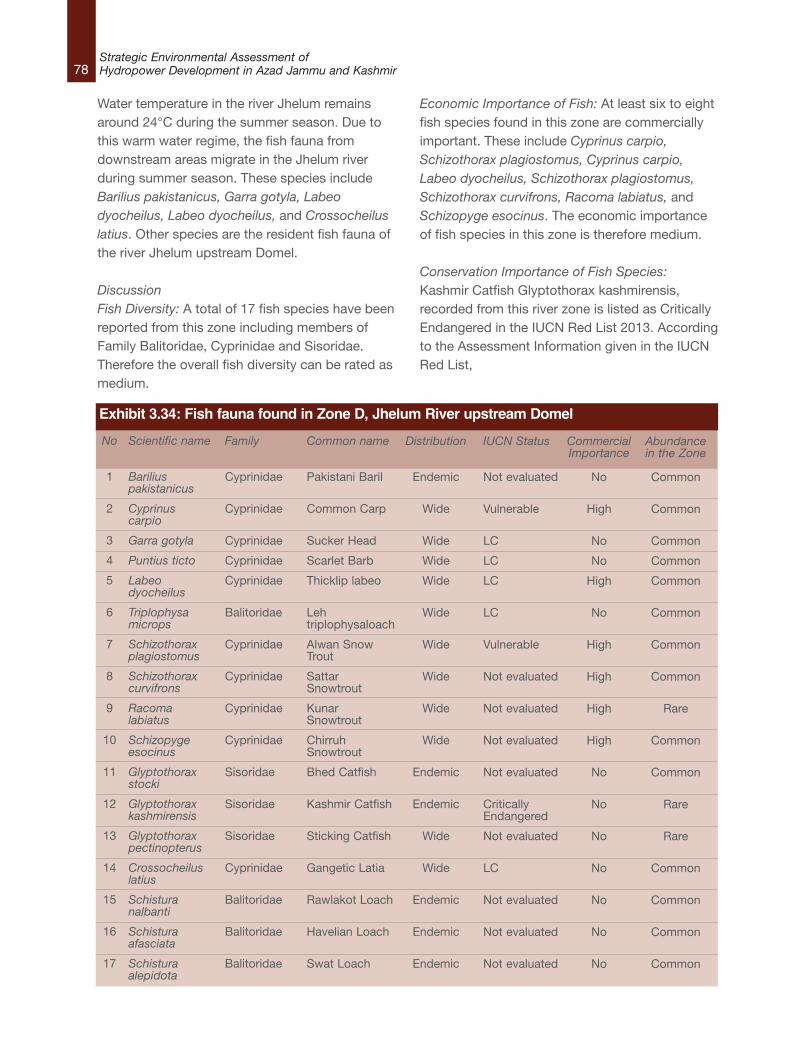
78Strategic Environmental Assessment ofHydropower Development in Azad Jammu and Kashmir
Water temperature in the river Jhelum remainsaround 24°C during the summer season. Due tothis warm water regime, the fish fauna fromdownstream areas migrate in the Jhelum riverduring summer season. These species includeBarilius pakistanicus, Garra gotyla, Labeodyocheilus, Labeo dyocheilus, and Crossocheiluslatius. Other species are the resident fish fauna ofthe river Jhelum upstream Domel.
DiscussionFish Diversity: A total of 17 fish species have beenreported from this zone including members ofFamily Balitoridae, Cyprinidae and Sisoridae.Therefore the overall fish diversity can be rated asmedium.
Economic Importance of Fish: At least six to eightfish species found in this zone are commerciallyimportant. These include Cyprinus carpio,Schizothorax plagiostomus, Cyprinus carpio,Labeo dyocheilus, Schizothorax plagiostomus,Schizothorax curvifrons, Racoma labiatus, andSchizopyge esocinus. The economic importanceof fish species in this zone is therefore medium.
Conservation Importance of Fish Species:Kashmir Catfish Glyptothorax kashmirensis,recorded from this river zone is listed as CriticallyEndangered in the IUCN Red List 2013. Accordingto the Assessment Information given in the IUCNRed List,
No
1
2
3
4
5
6
7
8
9
10
11
12
13
14
15
16
17
Scientific name
Bariliuspakistanicus
Cyprinuscarpio
Garra gotyla
Puntius ticto
Labeodyocheilus
Triplophysamicrops
Schizothoraxplagiostomus
Schizothoraxcurvifrons
Racomalabiatus
Schizopygeesocinus
Glyptothoraxstocki
Glyptothoraxkashmirensis
Glyptothoraxpectinopterus
Crossocheiluslatius
Schisturanalbanti
Schisturaafasciata
Schisturaalepidota
Family
Cyprinidae
Cyprinidae
Cyprinidae
Cyprinidae
Cyprinidae
Balitoridae
Cyprinidae
Cyprinidae
Cyprinidae
Cyprinidae
Sisoridae
Sisoridae
Sisoridae
Cyprinidae
Balitoridae
Balitoridae
Balitoridae
Common name
Pakistani Baril
Common Carp
Sucker Head
Scarlet Barb
Thicklip labeo
Lehtriplophysaloach
Alwan SnowTrout
SattarSnowtrout
KunarSnowtrout
ChirruhSnowtrout
Bhed Catfish
Kashmir Catfish
Sticking Catfish
Gangetic Latia
Rawlakot Loach
Havelian Loach
Swat Loach
Distribution
Endemic
Wide
Wide
Wide
Wide
Wide
Wide
Wide
Wide
Wide
Endemic
Endemic
Wide
Wide
Endemic
Endemic
Endemic
IUCN Status
Not evaluated
Vulnerable
LC
LC
LC
LC
Vulnerable
Not evaluated
Not evaluated
Not evaluated
Not evaluated
CriticallyEndangered
Not evaluated
LC
Not evaluated
Not evaluated
Not evaluated
CommercialImportance
No
High
No
No
High
No
High
High
High
High
No
No
No
No
No
No
No
Abundancein the Zone
Common
Common
Common
Common
Common
Common
Common
Common
Rare
Common
Common
Rare
Rare
Common
Common
Common
Common
Exhibit 3.34: Fish fauna found in Zone D, Jhelum River upstream Domel
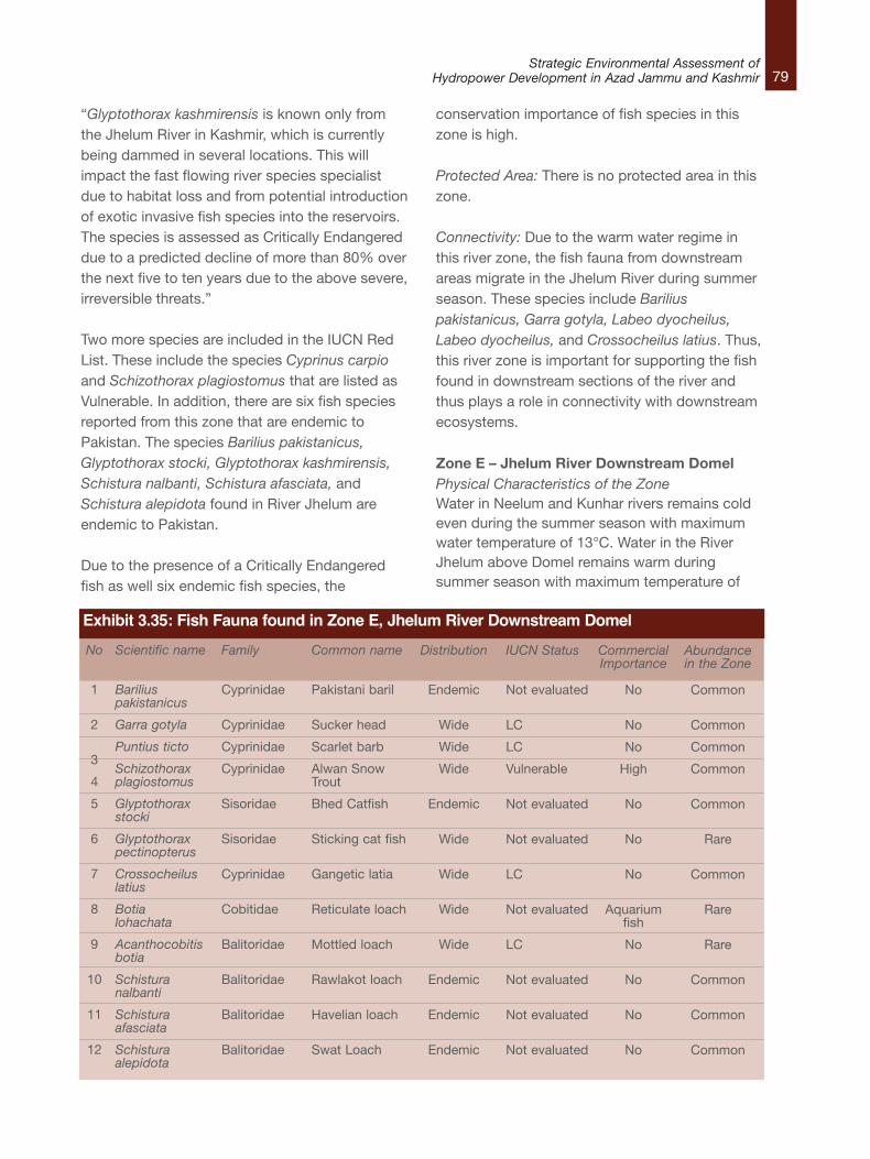
79Strategic Environmental Assessment of
Hydropower Development in Azad Jammu and Kashmir
“Glyptothorax kashmirensis is known only fromthe Jhelum River in Kashmir, which is currentlybeing dammed in several locations. This willimpact the fast flowing river species specialistdue to habitat loss and from potential introductionof exotic invasive fish species into the reservoirs.The species is assessed as Critically Endangereddue to a predicted decline of more than 80% overthe next five to ten years due to the above severe,irreversible threats.”
Two more species are included in the IUCN RedList. These include the species Cyprinus carpioand Schizothorax plagiostomus that are listed asVulnerable. In addition, there are six fish speciesreported from this zone that are endemic toPakistan. The species Barilius pakistanicus,Glyptothorax stocki, Glyptothorax kashmirensis,Schistura nalbanti, Schistura afasciata, andSchistura alepidota found in River Jhelum areendemic to Pakistan.
Due to the presence of a Critically Endangeredfish as well six endemic fish species, the
conservation importance of fish species in thiszone is high.
Protected Area: There is no protected area in thiszone.
Connectivity: Due to the warm water regime inthis river zone, the fish fauna from downstreamareas migrate in the Jhelum River during summerseason. These species include Bariliuspakistanicus, Garra gotyla, Labeo dyocheilus,Labeo dyocheilus, and Crossocheilus latius. Thus,this river zone is important for supporting the fishfound in downstream sections of the river andthus plays a role in connectivity with downstreamecosystems.
Zone E – Jhelum River Downstream DomelPhysical Characteristics of the ZoneWater in Neelum and Kunhar rivers remains coldeven during the summer season with maximumwater temperature of 13°C. Water in the RiverJhelum above Domel remains warm duringsummer season with maximum temperature of
No
1
2
3
4
5
6
7
8
9
10
11
12
Scientific name
Bariliuspakistanicus
Garra gotyla
Puntius ticto
Schizothoraxplagiostomus
Glyptothoraxstocki
Glyptothoraxpectinopterus
Crossocheiluslatius
Botialohachata
Acanthocobitisbotia
Schisturanalbanti
Schisturaafasciata
Schisturaalepidota
Family
Cyprinidae
Cyprinidae
Cyprinidae
Cyprinidae
Sisoridae
Sisoridae
Cyprinidae
Cobitidae
Balitoridae
Balitoridae
Balitoridae
Balitoridae
Common name
Pakistani baril
Sucker head
Scarlet barb
Alwan SnowTrout
Bhed Catfish
Sticking cat fish
Gangetic latia
Reticulate loach
Mottled loach
Rawlakot loach
Havelian loach
Swat Loach
Distribution
Endemic
Wide
Wide
Wide
Endemic
Wide
Wide
Wide
Wide
Endemic
Endemic
Endemic
IUCN Status
Not evaluated
LC
LC
Vulnerable
Not evaluated
Not evaluated
LC
Not evaluated
LC
Not evaluated
Not evaluated
Not evaluated
CommercialImportance
No
No
No
High
No
No
No
Aquariumfish
No
No
No
No
Abundancein the Zone
Common
Common
Common
Common
Common
Rare
Common
Rare
Rare
Common
Common
Common
Exhibit 3.35: Fish Fauna found in Zone E, Jhelum River Downstream Domel
80Strategic Environmental Assessment ofHydropower Development in Azad Jammu and Kashmir
24°C. Mean monthly flow rate of the River Neelumexceeds that of River Jhelum in the peak summermonths and this cold water from Neelum Riversignificantly affects the water temperature of theRiver Jhelum below Domel after their confluence.Consequently, water temperature of River Jhelumbelow Domel remains moderate and does not risebeyond 17°C. Three temperature regimes viz.,warm water regime in the river Jhelum aboveDomel, cold water regime in the river Neelum andKunhar and a cool water regime in the riverJhelum below Domel help the fish fauna todisperse in different parts of the rivers accordingto their optimal temperature choice.
Biological Characteristics of the ZoneThe fish species found in this stretch of river isindicated in Exhibit 3.35 along with associateddata.
The water in the river downstream of Domelbecomes cool as compared to upstream Domeldue to confluence of rivers Neelum and Kunhar. Italso runs through more gorges as compared tothe stretch upstream Domel. The water dischargealso increases as a result of confluence of Neelumand Kunhar. These factors reduce the number offish species in this stretch of river. All the snowtrout species found in the Jhelum upstreamDomel are not represented in this stretch of river.
DiscussionFish Diversity: A total of 12 fish species have beenreported from this zone including members ofFamily Balitoridae, Cyprinidae and Sisoridae. Theoverall fish diversity can be rated as medium.
Economic Importance of Fish: Only the AlwanSnow Trout Schizothorax plagiostomus is acommercially important edible fish species foundin this zone. Besides this, the Reticulate loachBotia lohachata is an aquarium fish but it is rare inthis zone. Overall, the fish fauna of this zone havean overall low economic importance.
Conservation Importance of Fish Species: NoEndangered or Critically Endangered fish specieshas been reported from this zone. The only fishfound here that has an IUCN status is theSchizothorax plagiostomus richardsonii.
Endemic fish species found in this zone includeGlyptothorax stocki, Schistura nalbanti, Schisturaafasciata, Schistura alepidota and Bariliuspakistanicus.
The conservation importance of the fish speciesin this zone can be labeled as low since AlwanSnow Trout Schizothorax plagiostomus as well asthe endemic fish are widely distributed and foundin the River Jhelum both upstream anddownstream Domel.
Protected Area: There is no protected area in thiszone.
Zone F – Jhelum River at and below theConfluence of Mahl Nullah Physical Characteristics of the ZoneWater temperature of this stretch of the river isquite high and reaches up to 28–30˚C duringsummer months. Owing to high temperature andcloseness to the Mangla dam, the area is mainlyoccupied by the warm water fish fauna with a fewspecies representing the cool water.
Biological Characteristics of the ZoneThe fish species found in this stretch of river isindicated in Exhibit 3.36 along with associateddata. Photographs of some of the species areincluded in Exhibit 3.37.
This stretch of the river receives the Mahl Nullahdraining the Bagh and Arja area. The Mahl Nullahis an open small stream with shallow water havingcobbly bed. It forms one of the habitat forbreeding of the fish species, Mahseer Tor putitora.This river stretch is influenced by the ManglaReservoir and the species Tor putitora, Clupisomagarua, Salmophasia punjabensis, Gagata cenia,and Securicula gora represent the reservoir fisheswhich have inhabited this stretch of the river. Thefish Schizothorax plagiostomus is just representedin this stretch and forms its southernmost limit.
DiscussionFish Diversity: A total of 12 fish species have beenreported from this zone including members ofFamily Balitoridae, Cyprinidae and Sisoridae. Theoverall fish diversity can be rated as medium.
81Strategic Environmental Assessment of
Hydropower Development in Azad Jammu and Kashmir
Economic Importance of Fish: The commerciallyimportant fish fauna of this zone includes the Torputitora and Clupisoma garua which havemigrated from the reservoir. However, theabundance of the Tor putitora in this zone is low.The other fish of commercial importance is theSchizothorax plagiostomus which is also very rarein this zone. Therefore, the economic importanceof fish in this zone can be labeled as low.
Conservation Importance of Fish Species: The fishspecies Mahseer Tor putitora is listed asEndangered in the IUCN Red List 2013. It hasbeen recorded from this zone particularly in theMahl Nullah that forms a habitat for breeding ofthis fish. A detailed write–up about this fishspecies is given in the description of the nextzone. The Vulnerable fish species Schizothoraxplagiostomus is also found in this zone but, is rarein this zone.
No
1
2
3
4
5
6
7
8
9
10
11
12
Scientific name
Bariliuspakistanicus
Salmophasiapunjabensis
Crossocheiluslatius
Securiculagora
Garra gotyla
Puntius ticto
Tor putitora
Schizothoraxplagiostomus
Glyptothoraxpectinopterus
Schisturanalbanti
Clupisomagarua
Gagata cenia
Family
Cyprinidae
Cyprinidae
Cyprinidae
Cyprinidae
Cyprinidae
Cyprinidae
Cyprinidae
Cyprinidae
Sisoridae
Balitoridae
Schilbeidae
Sisoridae
Common name
Pakistani baril
Punjab razorbellyminnow
Gangetic latia
Gora chela
Sucker head
Scarlet barb
Golden Mahseer
Alwan SnowTrout
Sticking cat fish
Rawlakot loach
Garua bachcha
Indian gagata
Distribution
Endemic
Endemic
Wide
Wide
Wide
Wide
Wide
Wide
Wide
Endemic
Wide
Wide
IUCN Status
Not evaluated
Not evaluated
LC
LC
LC
LC
Endangered
Vulnerable
Not evaluated
Not evaluated
LC
LC
CommercialImportance
No
No
No
No
No
No
High
High
No
No
Very high
No
Abundancein the Zone
Common
Common
Common
Common
Common
Common
Rare
Rare
Rare
Common
Rare
Common
Exhibit 3.36: Fish Fauna found in Zone F, Jhelum River at and below the Confluence of Mahl Nullah
Exhibit 3.37: Photographs of Fish Fauna found in Zone D, Zone E and Zone F (Jhelum River)
a. The Sucker head Garra gotyla b. The Chirruh snow trout Schiziopyge esocinus
c. Alwan Snow Trout Schizothorax plagiostomus d. Glyptothorax kashmirensis
82Strategic Environmental Assessment ofHydropower Development in Azad Jammu and Kashmir
Endemic fish species found in this zone includeSchistura nalbanti, Barilius pakistanicus andSalmophasia punjabensis.
The conservation importance of the fish speciesin this zone can be labeled as low since theabundance of the Mahseer Tor putitora is low inthis zone. Moreover the Alwan Snow TroutSchizothorax plagiostomus as well as theendemic fish are not restricted to this zone andwidely distributed in the Jhelum River bothupstream and downstream of Domel.
However, since the Mahl Nullah forms a breedinghabitat for Endangered Tor putitora, this stretch ofZone F (Mahl Nullah) can be labeled as High forthe conservation importance of fish.
Protected Area: There is no protected area in thiszone.
Zone G – Poonch RiverPhysical Characteristics of the ZoneThe Poonch is the warm water river and the watertemperature approaches to 30˚C during thesummer months.
Biological Characteristics of the ZoneThe fish species found in this river are indicated inExhibit 3.38 along with associated data.
Out of 29 species found in Poonch River, 13species viz., Barilius pakistanicus, Schisturapunjabensis, Cirrhinus reba, Labeo dero, Labeodyocheilus, Tor putitora, Schizothoraxplagiostomus (richardsonii), Cyprinus carpio, Botiarostrata, Sperata seenghala, Clupisoma garua,Ompok bimaculatus and Mastacembelus armatusare species of special importance (Exhibit 3.39).Photographs of some of the species are includedin Exhibit 3.40.
DiscussionFish Diversity: A total of 29 fish species have beenreported from this zone. River Poonch is rich infish diversity as 29 fish species have beenrecorded from a stretch of about 100 km. The
diversity is higher in the area where the RiverPoonch makes its confluence with ManglaReservoir. This diversity is quite high for a river ofthis size as compared to other rivers of AJK, theNeelum and Jhelum, which are bigger and longerrivers and have 12 to 32 fish species respectively.The reason is the topography and watertemperature of the river Poonch. The Poonchflows gently in a vast and flat valley whichprovides numerous breeding grounds for thereproduction of fish. High temperature andgravely, rocky and the sandy river bed of the riverPoonch not only helps for high river productivitybut also enhance the breeding capacity of aquaticorganisms and their subsequent survival. Thus thefish diversity of the fish in this zone is labeledHigh.
Economic Importance of Fish: Of species bearingIUCN status, Tor putitora, Schizothoraxplagiostomus (richardsonii), Cyprinus carpio, andOmpok bimaculatus are commercially important.The other commercially important species areSperata seenghala, Clupisoma garua,Mastacembelus armatus, and Cyprinus carpio.Some of these species such as Tor putitora,Sperata seenghala and Clupisoma garua havevery high commercial importance. So overall theeconomic importance of fish in this zone is high.
Conservation Importance of Fish Species: Thespecies, Barilius pakistanicus and Schisturapunjabensis are endemic to Pakistan. Fivespecies, Tor putitora (Endangered), Schizothoraxplagiostomus (richardsonii) (Vulnerable), Cyprinuscarpio (Vulnerable), Botia rostrata (Vulnerable),Ompok bimaculatus (Vulnerable) and Ompokbimaculatus (Near Threatened) have special IUCNstatus
The fish species Mahseer Tor putitora is animportant food and sport fish found in this zone.The largest and most stable population of this fishin the country in found in the Poonch River thatalso forms a breeding ground for this fish.Keeping in view its decling population and threatsto survival, it has been declared Endangered in
83Strategic Environmental Assessment of
Hydropower Development in Azad Jammu and Kashmir
No
1
2
3
4
5
6
7
8
9
10
11
12
13
14
15
16
17
18
19
20
21
22
23
24
25
26
27
28
29
Scientific name
Chela cachius
Salmophasiabacaila
Aspidopariamorar
Bariliuspakistanicus
Esomusdanricus
Cirrhinus reba
Cyprinionwatsoni
Labeo dero
Labeodyocheilus
Osteobramacotio
Puntius chola
Puntiussophore
Puntius ticto
Tor putitora
Crossocheiluslatius
Garra gotyla
Schizothoraxplagiostomus(richardsonii)
Cyprinus carpio
Acanthocobitisbotia
Schisturapunjabensis
Botia rostrata
Sperataseenghala
Clupisomagarua
Ompokbimaculatus
Glyptothoraxpectinopterus
Chanda nama
Parambasisbaculis
Parambasisranga
Mastacembelusarmatus
Family
Cyprinidae
Cyprinidae
Cyprinidae
Cyprinidae
Cyprinidae
Cyprinidae
Cyprinidae
Cyprinidae
Cyprinidae
Cyprinidae
Cyprinidae
Cyprinidae
Cyprinidae
Cyprinidae
Cyprinidae
Cyprinidae
Cyprinidae
Cyprinidae
Noemacheilidae
Noemacheilidae
Cobitidae
Bagridae
Schilbeidae
Siluridae
Sisoridae
Channidae
Chandidae
Chandidae
Mastacembelidae
English Name
Silver hatchet chela
Large razorbellyminnow
Aspidoparia
Pakistani baril
Flying barb
Reba carp
Cyprinion
Kalbans
Pakistani Labeo
Cotio
Swamp Barb
Spotfin SwampBarb
Two spot Barb
Mahseer
Gangetic latia
Sucker head
Snow carp
Common carp
Mottled Loach
Hillstream loach
Twin–banded Loach
Giant river cat fish
Garua bachwaa
Butter Catfish
Flat head Catfish
Elongate glass–perchlet
Himalayan glassyperchlet
Indian glassy fish
Tire–track spiny eel
Distributionalstatus
Wide
Wide
Wide
Endemic
Wide
Wide
Wide
Wide
Wide
Wide
Wide
Wide
Wide
Wide
Wide
Wide
Wide
Exotic
Wide
Endemic
Wide
Wide
Wide
Wide
Wide
Wide
Wide
Wide
Wide
IUCN Status
LC
LC
LC
Not determined(ND)
LC
LC
ND
LC
LC
LC
LC
LC
LC
Endangered
LC
LC
Vulnerable
Vulnerable
LC
ND
Vulnerable
LC
LC
NearThreatened
LC
LC
LC
LC
LC
CommercialValue
Low
Low
Low
Low
Low
Fairly good
Low
Fairly good
High
Low
Low
Low
Low
Very high
Low
Low
High
High
Low
Low
Low
Very high
Very high
Low
Low
Low
High
Exhibit 3.38: Fish fauna found in Zone G – Poonch River
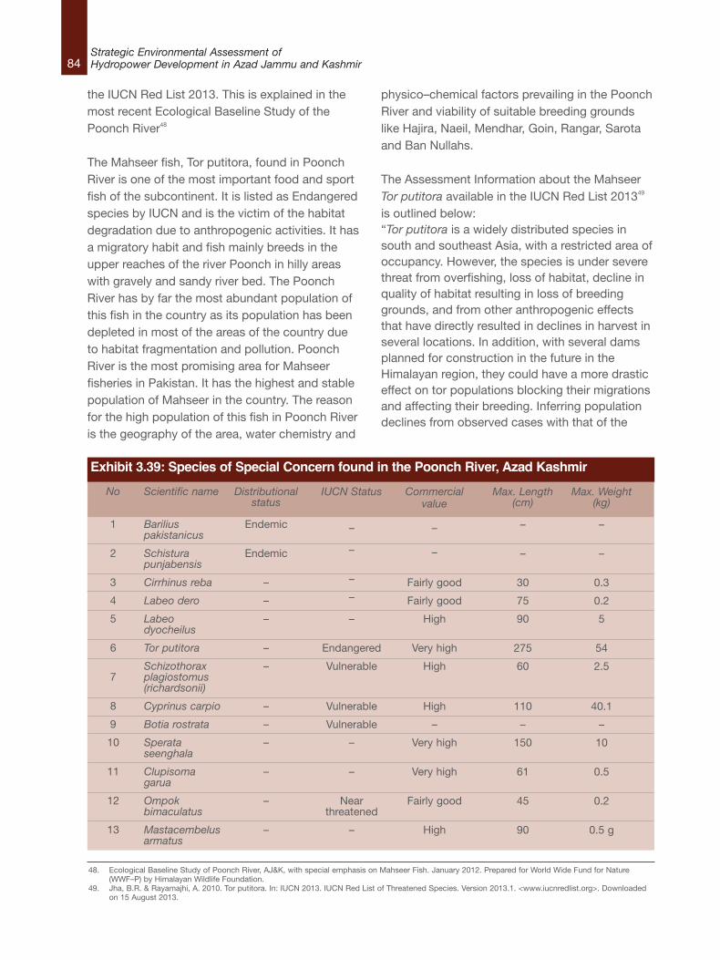
84Strategic Environmental Assessment ofHydropower Development in Azad Jammu and Kashmir
the IUCN Red List 2013. This is explained in themost recent Ecological Baseline Study of thePoonch River48
The Mahseer fish, Tor putitora, found in PoonchRiver is one of the most important food and sportfish of the subcontinent. It is listed as Endangeredspecies by IUCN and is the victim of the habitatdegradation due to anthropogenic activities. It hasa migratory habit and fish mainly breeds in theupper reaches of the river Poonch in hilly areaswith gravely and sandy river bed. The PoonchRiver has by far the most abundant population ofthis fish in the country as its population has beendepleted in most of the areas of the country dueto habitat fragmentation and pollution. PoonchRiver is the most promising area for Mahseerfisheries in Pakistan. It has the highest and stablepopulation of Mahseer in the country. The reasonfor the high population of this fish in Poonch Riveris the geography of the area, water chemistry and
physico–chemical factors prevailing in the PoonchRiver and viability of suitable breeding groundslike Hajira, Naeil, Mendhar, Goin, Rangar, Sarotaand Ban Nullahs.
The Assessment Information about the MahseerTor putitora available in the IUCN Red List 201349
is outlined below: “Tor putitora is a widely distributed species insouth and southeast Asia, with a restricted area ofoccupancy. However, the species is under severethreat from overfishing, loss of habitat, decline inquality of habitat resulting in loss of breedinggrounds, and from other anthropogenic effectsthat have directly resulted in declines in harvest inseveral locations. In addition, with several damsplanned for construction in the future in theHimalayan region, they could have a more drasticeffect on tor populations blocking their migrationsand affecting their breeding. Inferring populationdeclines from observed cases with that of the
48. Ecological Baseline Study of Poonch River, AJ&K, with special emphasis on Mahseer Fish. January 2012. Prepared for World Wide Fund for Nature(WWF–P) by Himalayan Wildlife Foundation.
49. Jha, B.R. & Rayamajhi, A. 2010. Tor putitora. In: IUCN 2013. IUCN Red List of Threatened Species. Version 2013.1. <www.iucnredlist.org>. Downloadedon 15 August 2013.
No
1
2
3
4
5
6
7
8
9
10
11
12
13
Scientific name
Bariliuspakistanicus
Schisturapunjabensis
Cirrhinus reba
Labeo dero
Labeodyocheilus
Tor putitora
Schizothoraxplagiostomus(richardsonii)
Cyprinus carpio
Botia rostrata
Sperataseenghala
Clupisomagarua
Ompokbimaculatus
Mastacembelusarmatus
Distributionalstatus
Endemic
Endemic
–
–
–
–
–
–
–
–
–
–
–
IUCN Status
–
–
–
–
–
Endangered
Vulnerable
Vulnerable
Vulnerable
–
–
Nearthreatened
–
Commercialvalue
–
–
Fairly good
Fairly good
High
Very high
High
High
–
Very high
Very high
Fairly good
High
Max. Length(cm)
–
–
30
75
90
275
60
110
–
150
61
45
90
Max. Weight(kg)
–
–
0.3
0.2
5
54
2.5
40.1
–
10
0.5
0.2
0.5 g
Exhibit 3.39: Species of Special Concern found in the Poonch River, Azad Kashmir
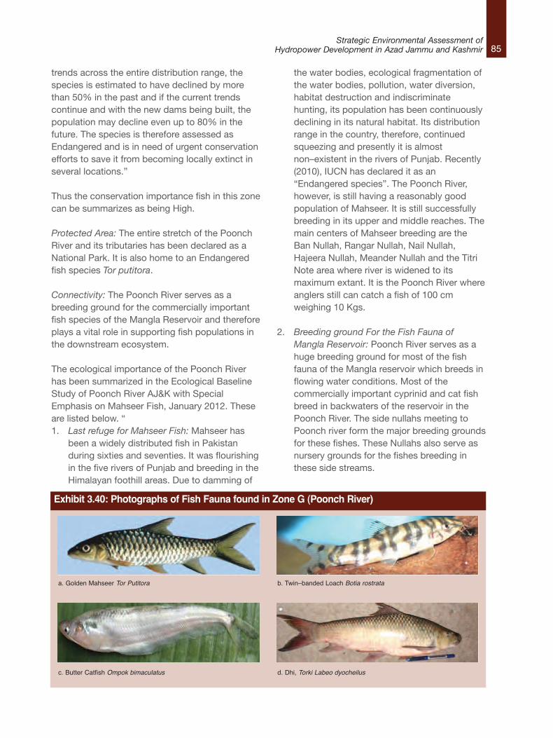
85Strategic Environmental Assessment of
Hydropower Development in Azad Jammu and Kashmir
trends across the entire distribution range, thespecies is estimated to have declined by morethan 50% in the past and if the current trendscontinue and with the new dams being built, thepopulation may decline even up to 80% in thefuture. The species is therefore assessed asEndangered and is in need of urgent conservationefforts to save it from becoming locally extinct inseveral locations.”
Thus the conservation importance fish in this zonecan be summarizes as being High.
Protected Area: The entire stretch of the PoonchRiver and its tributaries has been declared as aNational Park. It is also home to an Endangeredfish species Tor putitora.
Connectivity: The Poonch River serves as abreeding ground for the commercially importantfish species of the Mangla Reservoir and thereforeplays a vital role in supporting fish populations inthe downstream ecosystem.
The ecological importance of the Poonch Riverhas been summarized in the Ecological BaselineStudy of Poonch River AJ&K with SpecialEmphasis on Mahseer Fish, January 2012. Theseare listed below. “ 1. Last refuge for Mahseer Fish: Mahseer has
been a widely distributed fish in Pakistanduring sixties and seventies. It was flourishingin the five rivers of Punjab and breeding in theHimalayan foothill areas. Due to damming of
the water bodies, ecological fragmentation ofthe water bodies, pollution, water diversion,habitat destruction and indiscriminatehunting, its population has been continuouslydeclining in its natural habitat. Its distributionrange in the country, therefore, continuedsqueezing and presently it is almostnon–existent in the rivers of Punjab. Recently(2010), IUCN has declared it as an“Endangered species”. The Poonch River,however, is still having a reasonably goodpopulation of Mahseer. It is still successfullybreeding in its upper and middle reaches. Themain centers of Mahseer breeding are theBan Nullah, Rangar Nullah, Nail Nullah,Hajeera Nullah, Meander Nullah and the TitriNote area where river is widened to itsmaximum extant. It is the Poonch River whereanglers still can catch a fish of 100 cmweighing 10 Kgs.
2. Breeding ground For the Fish Fauna ofMangla Reservoir: Poonch River serves as ahuge breeding ground for most of the fishfauna of the Mangla reservoir which breeds inflowing water conditions. Most of thecommercially important cyprinid and cat fishbreed in backwaters of the reservoir in thePoonch River. The side nullahs meeting toPoonch river form the major breeding groundsfor these fishes. These Nullahs also serve asnursery grounds for the fishes breeding inthese side streams.
Exhibit 3.40: Photographs of Fish Fauna found in Zone G (Poonch River)
a. Golden Mahseer Tor Putitora b. Twin–banded Loach Botia rostrata
c. Butter Catfish Ompok bimaculatus d. Dhi, Torki Labeo dyocheilus
86Strategic Environmental Assessment ofHydropower Development in Azad Jammu and Kashmir
3. Natural Reserve for Twin–banded Loach, Botiarostrata: Twin banded loach is a beautifulaquarium fish. It has almost the same story asthat of Mahseer. The fish has been quitecommon in the Himalayan foothill areas butpresently its population in the foothill areas isalmost depleted or non–existent. The PoonchRiver has a very good population of this loachand is a hot spot area for this fish.
4. Supporting Healthy Population of Labeodyocheilus: Poonch River holds the largestpopulation of Labeo dyocheilus as comparedto any other river in the country. This fish hasmaximum size in this river and a fish weighing3–4 kg is commonly caught in the nets.
5. Supporting Healthy Population of Garragotyla: The fish Garra gotyla is also a fish ofsubmountanous areas but it is also found inplains. Its population in plain areas hasdecreased over the last 20 years and hardlyone comes across any fish while sampling.Once upon a time it was very common inPotowar areas but it is no more seen in any ofthese areas except a few localized places.Poonch River has very healthy population ofthis fish throughout its length in AJK.
6. Supporting High fish diversity as compared toits size: The Poonch is the smallest river inAJK as compared to other two rivers, theJhelum and the Neelum. It, however, has avery good fish diversity of 29 species ascompared to 32 species in Jhelum and 12species in Neelum. It is due to optimum watertemperature, pristine breeding grounds, wideriver valley, and network of side nullahs withsuitable physic–chemical environment.”
Zone H – Mangla Reservoir Physical Characteristics of the ZoneThe Kunhar and Neelum are cold–water rivershaving water temperature less than 15˚C evenduring the summer months. The Poonch is awarm water river and the water temperature of therivers approaches 30˚C during the summer
months. Water in the Jhelum River has anintermediate temperature which reaches up to25˚C during the summer months. These variabletemperature regimes give the reservoir a uniquephysico–chemical characteristic and fish fauna ofall the water bodies are represented in thereservoir to variable extents in addition to majorinfluence of the downstream areas of the plains.
Biological Characteristics of the ZoneThe fish species found in this river are indicated inExhibit 3.41 and Exhibit 3.42 along withassociated data.
DiscussionFish Diversity: A total of 57 fish species have beenreported from this zone and the overall fishdiversity can be labeled as Very High. Economic Importance of Fish: Mangla reservoir isimportant for supporting several commerciallyimportant fish. There are at least 18 commerciallyimportant fish present in this zone as indicated inExhibit 3.41. Therefore the economic importanceof this zone is high.
Conservation Importance of Fish Species: The fishspecies Mahseer Tor putitora habitat is listed asEndangered in the IUCN Red List 2013. It hasbeen recorded from this zone even though it israre in this zone. The Cyprinus carpio is listed asVulnerable while the species listed as NearThreatened include Chitala chitala,Hypophthalmichthys molitrix, Oreochromismossambicus, Ompok bimaculatus, Ompok pabd,Wallago attu and Bagarius bagarius.
The conservation importance of the fish speciesin this zone can be labeled as Medium since theendangered fish, Tor putitora does not have a highabundance in this zone. The other fish species areeither Vulnerable or Near Threatened.
Protected Area: There is no protected area in thiszone.
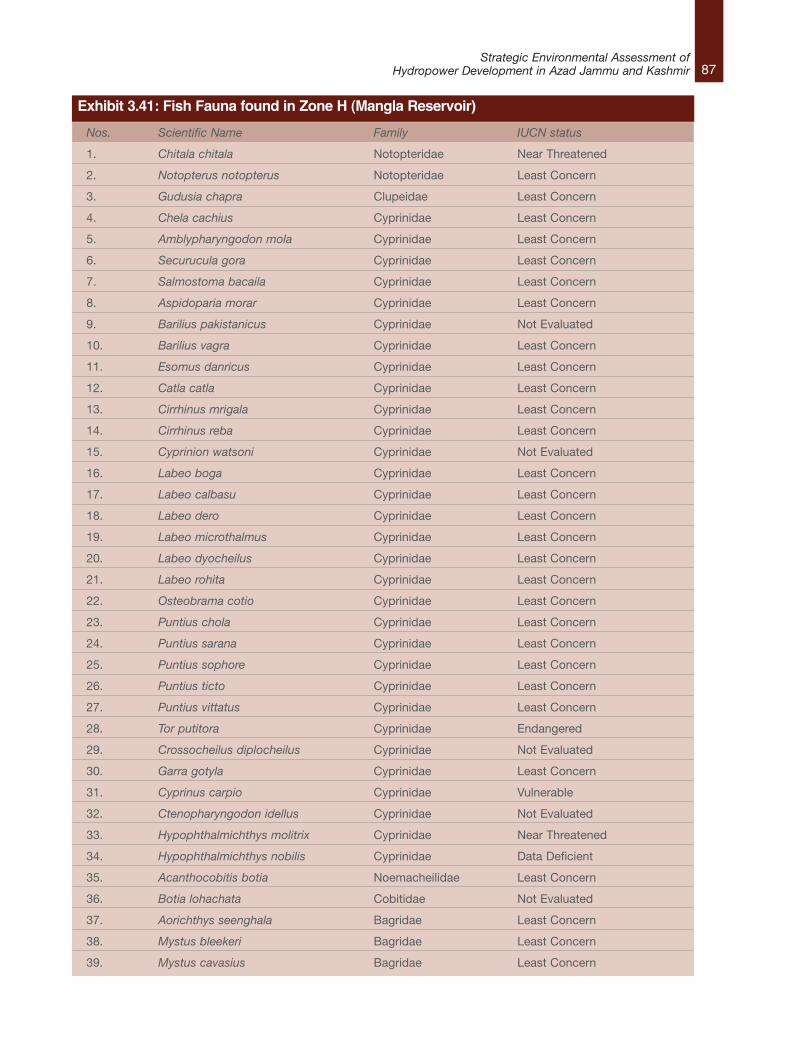
87Strategic Environmental Assessment of
Hydropower Development in Azad Jammu and Kashmir
Nos. Scientific Name Family IUCN status
1. Chitala chitala Notopteridae Near Threatened
2. Notopterus notopterus Notopteridae Least Concern
3. Gudusia chapra Clupeidae Least Concern
4. Chela cachius Cyprinidae Least Concern
5. Amblypharyngodon mola Cyprinidae Least Concern
6. Securucula gora Cyprinidae Least Concern
7. Salmostoma bacaila Cyprinidae Least Concern
8. Aspidoparia morar Cyprinidae Least Concern
9. Barilius pakistanicus Cyprinidae Not Evaluated
10. Barilius vagra Cyprinidae Least Concern
11. Esomus danricus Cyprinidae Least Concern
12. Catla catla Cyprinidae Least Concern
13. Cirrhinus mrigala Cyprinidae Least Concern
14. Cirrhinus reba Cyprinidae Least Concern
15. Cyprinion watsoni Cyprinidae Not Evaluated
16. Labeo boga Cyprinidae Least Concern
17. Labeo calbasu Cyprinidae Least Concern
18. Labeo dero Cyprinidae Least Concern
19. Labeo microthalmus Cyprinidae Least Concern
20. Labeo dyocheilus Cyprinidae Least Concern
21. Labeo rohita Cyprinidae Least Concern
22. Osteobrama cotio Cyprinidae Least Concern
23. Puntius chola Cyprinidae Least Concern
24. Puntius sarana Cyprinidae Least Concern
25. Puntius sophore Cyprinidae Least Concern
26. Puntius ticto Cyprinidae Least Concern
27. Puntius vittatus Cyprinidae Least Concern
28. Tor putitora Cyprinidae Endangered
29. Crossocheilus diplocheilus Cyprinidae Not Evaluated
30. Garra gotyla Cyprinidae Least Concern
31. Cyprinus carpio Cyprinidae Vulnerable
32. Ctenopharyngodon idellus Cyprinidae Not Evaluated
33. Hypophthalmichthys molitrix Cyprinidae Near Threatened
34. Hypophthalmichthys nobilis Cyprinidae Data Deficient
35. Acanthocobitis botia Noemacheilidae Least Concern
36. Botia lohachata Cobitidae Not Evaluated
37. Aorichthys seenghala Bagridae Least Concern
38. Mystus bleekeri Bagridae Least Concern
39. Mystus cavasius Bagridae Least Concern
Exhibit 3.41: Fish Fauna found in Zone H (Mangla Reservoir)
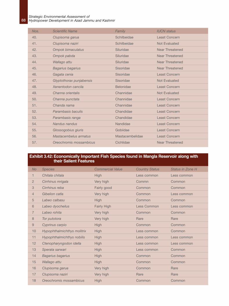
88Strategic Environmental Assessment ofHydropower Development in Azad Jammu and Kashmir
Nos. Scientific Name Family IUCN status
40. Clupisoma garua Schilbeidae Least Concern
41. Clupisoma naziri Schilbeidae Not Evaluated
42. Ompok bimaculatus Siluridae Near Threatened
43. Ompok pabda Siluridae Near Threatened
44. Wallago attu Siluridae Near Threatened
45. Bagarius bagarius Sisoridae Near Threatened
46. Gagata cenia Sisoridae Least Concern
47. Glyptothorax punjabensis Sisoridae Not Evaluated
48. Xenentodon cancila Belonidae Least Concern
49. Channa orientalis Channidae Not Evaluated
50. Channa punctata Channidae Least Concern
51. Chanda nama Channidae Least Concern
52. Parambasis baculis Chandidae Least Concern
53. Parambasis ranga Chandidae Least Concern
54. Nandus nandus Nandidae Least Concern
55. Glossogobius giuris Gobiidae Least Concern
56. Mastacembelus armatus Mastacembelidae Least Concern
57. Oreochromis mossambicus Cichlidae Near Threatened
No Species Commercial Value Country Status Status in Zone H
1 Chitala chitala High Less common Less common
2 Cirrhinus mrigala Very high Commn Common
3 Cirrhinus reba Fairly good Common Common
4 Gibelion catla Very high Common Less common
5 Labeo calbasu High Common Common
6 Labeo dyocheilus Fairly High Less Common Less common
7 Labeo rohita Very high Common Common
8 Tor putotora Very high Rare Rare
9 Cyprinus carpio High Common Common
10 Hypophthalmichthys molitrix High Less common Common
11 Hypophthalmichthys nobilis High Less common Less common
12 Ctenopharyngodon idella High Less common Less common
13 Sperata sarwari High Less common Common
14 Bagarius bagarius High Common Common
15 Wallago attu High Common Common
16 Clupisoma garua Very high Common Rare
17 Clupisoma naziri Very high Rare Rare
18 Oreochromis mossambicus High Common Common
Exhibit 3.42:Economically Important Fish Species found in Mangla Reservoir along with their Salient Features
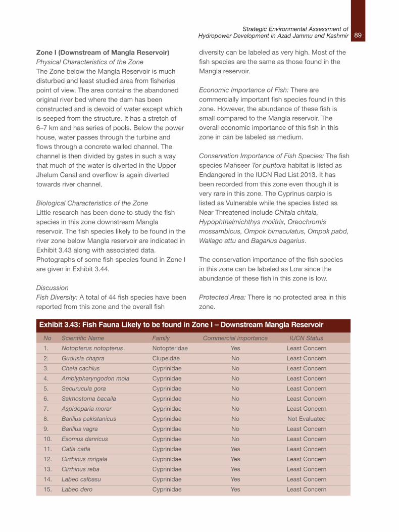
89Strategic Environmental Assessment of
Hydropower Development in Azad Jammu and Kashmir
No Scientific Name Family Commercial importance IUCN Status
1. Notopterus notopterus Notopteridae Yes Least Concern
2. Gudusia chapra Clupeidae No Least Concern
3. Chela cachius Cyprinidae No Least Concern
4. Amblypharyngodon mola Cyprinidae No Least Concern
5. Securucula gora Cyprinidae No Least Concern
6. Salmostoma bacaila Cyprinidae No Least Concern
7. Aspidoparia morar Cyprinidae No Least Concern
8. Barilius pakistanicus Cyprinidae No Not Evaluated
9. Barilius vagra Cyprinidae No Least Concern
10. Esomus danricus Cyprinidae No Least Concern
11. Catla catla Cyprinidae Yes Least Concern
12. Cirrhinus mrigala Cyprinidae Yes Least Concern
13. Cirrhinus reba Cyprinidae Yes Least Concern
14. Labeo calbasu Cyprinidae Yes Least Concern
15. Labeo dero Cyprinidae Yes Least Concern
Exhibit 3.43: Fish Fauna Likely to be found in Zone I – Downstream Mangla Reservoir
Zone I (Downstream of Mangla Reservoir)Physical Characteristics of the ZoneThe Zone below the Mangla Reservoir is muchdisturbed and least studied area from fisheriespoint of view. The area contains the abandonedoriginal river bed where the dam has beenconstructed and is devoid of water except whichis seeped from the structure. It has a stretch of6–7 km and has series of pools. Below the powerhouse, water passes through the turbine andflows through a concrete walled channel. Thechannel is then divided by gates in such a waythat much of the water is diverted in the UpperJhelum Canal and overflow is again divertedtowards river channel.
Biological Characteristics of the ZoneLittle research has been done to study the fishspecies in this zone downstream Manglareservoir. The fish species likely to be found in theriver zone below Mangla reservoir are indicated inExhibit 3.43 along with associated data.Photographs of some fish species found in Zone Iare given in Exhibit 3.44.
DiscussionFish Diversity: A total of 44 fish species have beenreported from this zone and the overall fish
diversity can be labeled as very high. Most of thefish species are the same as those found in theMangla reservoir.
Economic Importance of Fish: There arecommercially important fish species found in thiszone. However, the abundance of these fish issmall compared to the Mangla reservoir. Theoverall economic importance of this fish in thiszone in can be labeled as medium.
Conservation Importance of Fish Species: The fishspecies Mahseer Tor putitora habitat is listed asEndangered in the IUCN Red List 2013. It hasbeen recorded from this zone even though it isvery rare in this zone. The Cyprinus carpio islisted as Vulnerable while the species listed asNear Threatened include Chitala chitala,Hypophthalmichthys molitrix, Oreochromismossambicus, Ompok bimaculatus, Ompok pabd,Wallago attu and Bagarius bagarius.
The conservation importance of the fish speciesin this zone can be labeled as Low since theabundance of these fish in this zone is low.
Protected Area: There is no protected area in thiszone.
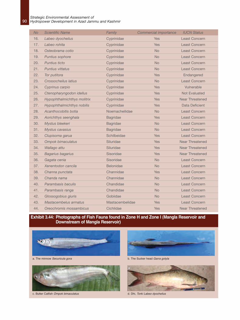
90Strategic Environmental Assessment ofHydropower Development in Azad Jammu and Kashmir
No Scientific Name Family Commercial importance IUCN Status
16. Labeo dyocheilus Cyprinidae Yes Least Concern
17. Labeo rohita Cyprinidae Yes Least Concern
18. Osteobrama cotio Cyprinidae No Least Concern
19. Puntius sophore Cyprinidae No Least Concern
20. Puntius ticto Cyprinidae No Least Concern
21. Puntius vittatus Cyprinidae No Least Concern
22. Tor putitora Cyprinidae Yes Endangered
23. Crossocheilus latius Cyprinidae No Least Concern
24. Cyprinus carpio Cyprinidae Yes Vulnerable
25. Ctenopharyngodon idellus Cyprinidae Yes Not Evaluated
26. Hypophthalmichthys molitrix Cyprinidae Yes Near Threatened
27. Hypophthalmichthys nobilis Cyprinidae Yes Data Deficient
28. Acanthocobitis botia Noemacheilidae No Least Concern
29. Aorichthys seenghala Bagridae Yes Least Concern
30. Mystus bleekeri Bagridae No Least Concern
31. Mystus cavasius Bagridae No Least Concern
32. Clupisoma garua Schilbeidae Yes Least Concern
33. Ompok bimaculatus Siluridae Yes Near Threatened
34. Wallago attu Siluridae Yes Near Threatened
35. Bagarius bagarius Sisoridae Yes Near Threatened
36. Gagata cenia Sisoridae No Least Concern
37. Xenentodon cancila Belonidae No Least Concern
38. Channa punctata Channidae Yes Least Concern
39. Chanda nama Channidae No Least Concern
40. Parambasis baculis Chandidae No Least Concern
41. Parambasis ranga Chandidae No Least Concern
42. Glossogobius giuris Gobiidae No Least Concern
43. Mastacembelus armatus Mastacembelidae Yes Least Concern
44. Oreochromis mossambicus Cichlidae Yes Near Threatened
Exhibit 3.44: Photographs of Fish Fauna found in Zone H and Zone I (Mangla Reservoir and Downstream of Mangla Reservoir)
a. The minnow Securicula gora b. The Sucker head Garra gotyla
c. Butter Catfish Ompok bimaculatus d. Dhi, Torki Labeo dyocheilus
91Strategic Environmental Assessment of
Hydropower Development in Azad Jammu and Kashmir
3.4.3 Sensitivity Zoning for HydropowerDevelopment The previous section assessed the ecologicalimportance of each of the nine designatedecological zones of the rivers of AJK by using thediversity of the fish species of each zone asindicators. The following parameters were used: l Fish Diversity
l Economic Importance of Fish
l Conservation Importance of Fish
l Classification as Protected Area
In addition, the connectivity to upstream anddownstream ecosystems was taken intoconsideration to assess the ecological importanceof each zone.
This section assesses the sensitivity of eachdesignated zone to hydropower developmentkeeping in view the ecological importance of eachzone based on the above–mentioned parameters.
Impacts of Dams on River EcosystemsThere is a constant interchange of materials,energy and nutrients between the water in theriver, its banks, its bed and its floodplains. Duringthe course of the water’s passage from source tosea sediments are continuously transported,sorted by size, re–sorted, eroded and depositedby the daily, yearly and decadal variations in flow,giving rise to permanent and semi–permanentriver–channel features, such as pools, rapids,ox–bow lakes, sandbars and floodplains. Thefloodplains are areas of fertile soils, replenishedby the river during each flood and often highlyvalued as agricultural land. The dynamic,ever–changing environment creates thephysical–chemical template upon which the river’sorganisms live their lives.50
The changing conditions along a river result in anorderly and predictable transition of species.Different plants and animals live in the headwaters
than in the lower reaches and different plantcommunities occur high on banks than lowerdown near the water. Some fish species need tomove onto seasonally inundated floodplains tocomplete their life cycles whilst others need theconditions provided in–channel throughout theirlives. Some animal species need to migrate upand downstream at different times of the year orinto and out of tributaries, to find appropriatetemperature and other conditions. Some plantsand animals live in pools and others infast–flowing rapids and riffles, some in colderwater and some in warmer environments, and so on.
Similarly, species respond to temporal changes inchanging flow conditions, with each river’s mix ofplant and animal species having evolved overmillennia to live in synchrony with its unique shortand long term cyclical flow patterns. Plantspecies have evolved to flower and fruit atspecific times of the annual flow cycle, fish timetheir spawning to coincide with the optimal flowand temperature conditions for their young tosurvive, and insects emerge from the water tomate and release their eggs at specific times ofthe year when air temperatures, food and otherconditions are optimal. Some species thrive indrier years and others in wetter years, and so thebalance of species is maintained with nonedominating but rather the mix of species changingfrom year to year. For all of these organisms theriver provides breeding sites, a nursery for theiryoung, a highway along which they migrate and avehicle for dispersing the next generation.
Both the spatial and temporal responses of plantsand animals to changing conditions are usuallyset within quite specific limits—limits that areusually not known or only barely understood byhumans. In most cases, we manage riverecosystems without good knowledge of whatspecies they support, even less the needs ofthose species for survival. In our ignorance,however, we do at least now better understandthat any physical or chemical change to an
50. Hagler Bailly Pakistan, Water Matters – South Africa, Southern Waters – South Africa, National Engineering Services Pakistan (NESPAK), 2011,Environmental Assessment of Kishenganga /Neelum River Water Diversion. Report prepared for Pakistan Commission for Indus Waters, Lahore.
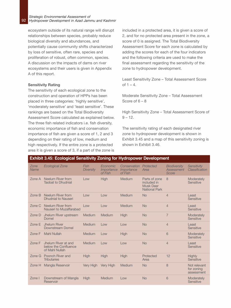
92Strategic Environmental Assessment ofHydropower Development in Azad Jammu and Kashmir
ecosystem outside of its natural range will disruptrelationships between species, probably reducebiological diversity and abundances, andpotentially cause community shifts characterizedby loss of sensitive, often rare, species andproliferation of robust, often common, species.A discussion on the impacts of dams on riverecosystems and their users is given in AppendixA of this report.
Sensitivity Rating The sensitivity of each ecological zone to theconstruction and operation of HPPs has beenplaced in three categories: ‘highly sensitive’,‘moderately sensitive’ and ‘least sensitive’. Theserankings are based on the Total BiodiversityAssessment Score calculated as explained below.The three fish related indicators i.e. fish diversity,economic importance of fish and conservationimportance of fish are given a score of 1, 2 and 3depending on their rating of low, medium andhigh respectively. If the entire zone is a protectedarea it is given a score of 3, if a part of the zone is
included in a protected area, it is given a score of2, and for no protected area present in the zone, ascore of 0 is assigned. The Total BiodiversityAssessment Score for each zone is calculated byadding the scores for each of the four indicatorsand the following criteria are used to make thefinal assessment regarding the sensitivity of thezone to hydropower development.
Least Sensitivity Zone – Total Assessment Scoreof 1 – 4.
Moderate Sensitivity Zone – Total AssessmentScore of 6 – 8
High Sensitivity Zone – Total Assessment Score of9 – 12.
The sensitivity rating of each designated riverzone to hydropower development is shown inExhibit 3.45 and a map of this sensitivity zoning isshown in Exhibit 3.46.
ZoneName
Zone A
Zone B
Zone C
Zone D
Zone E
Zone F
Zone F
Zone G
Zone H
Zone I
Ecological Zone
Neelum River fromTaobat to Dhudnial
Neelum River fromDhudnial to Nauseri
Neelum River fromNauseri to Muzaffarabad
Jhelum River upstreamDomel
Jhelum RiverDownstream Domel
Mahl Nullah
Jhelum River at andbelow the Confluenceof Mahl Nullah
Poonch River andTributaries
Mangla Reservoir
Downstream of ManglaReservoir
FishDiversity
Low
Low
Low
Medium
Medium
Medium
Medium
High
Very High
High
EconomicImportanceof Fish
High
Low
Low
Medium
Low
Low
Low
High
Very High
Medium
ConservationImportanceof Fish
Medium
Medium
Medium
High
Low
High
Low
High
Medium
Low
ProtectedArea
Parts of zoneincluded inMusk DeerNational Park
No
No
No
No
No
No
ProtectedArea
No
No
BiodiversityAssessmentScore
8
4
4
7
4
6
4
12
8
6
SensitivityClassification
ModeratelySensitive
LeastSensitive
LeastSensitive
ModeratelySensitive
LeastSensitive
ModeratelySensitive
LeastSensitive
HighlySensitive
Not relevantfor zoningassessment
ModeratelySensitive
Exhibit 3.45: Ecological Sensitivity Zoning for Hydropower Development
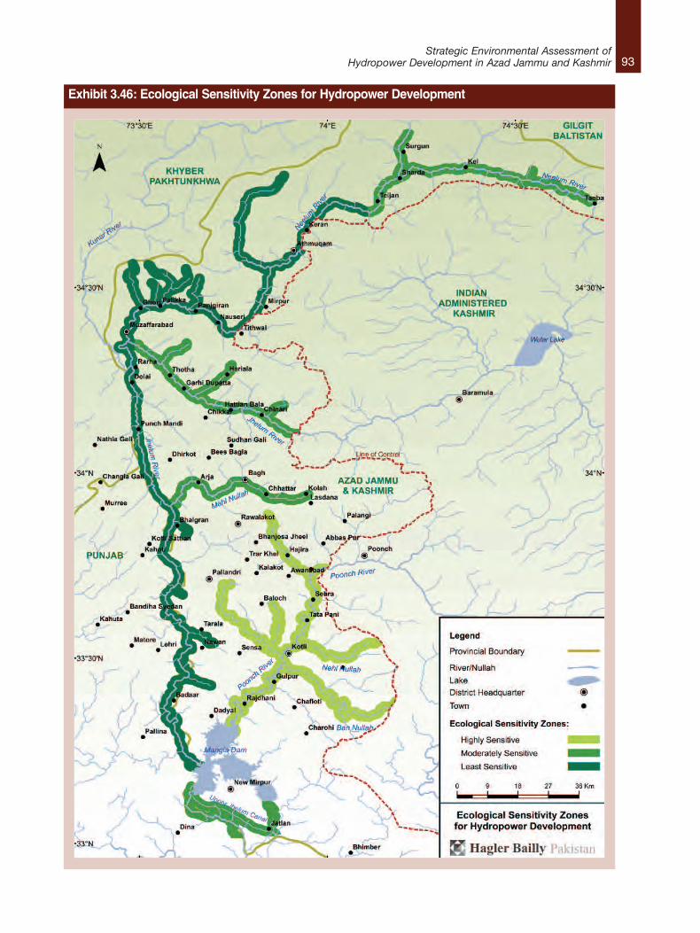
93Strategic Environmental Assessment of
Hydropower Development in Azad Jammu and Kashmir
Exhibit 3.46: Ecological Sensitivity Zones for Hydropower Development
94Strategic Environmental Assessment ofHydropower Development in Azad Jammu and Kashmir
DiscussionAs shown in the summary table in Exhibit 3.45,only one designated river zone has beencategorized as Highly Sensitive. This is Zone Gthat includes Poonch River and tributaries. Thezones that have been categorized as ModeratelySensitive include Zone A (Neelum River fromTaobat to Dudhnial), Zone D (Jhelum Riverupstream Dudhnial), one section of Zone F (MahlNullah) and Zone I (Downstream ManglaReservoir). The reasons for these categorizationsare discussed below.
Highly Sensitive ZoneOnly the River Zone G that includes the PoonchRiver and tributaries has been categorized asHighly Sensitive to the construction and operationof HPPs. This is because this zone has high fishdiversity, high economic and commercialimportance of fish and is also a designatednational park. The salient features of this zonethat justify its designation as highly sensitive areoutlined below: l High fish diversity of 29 fish species in a
stretch of about 100 km.
l Presence of economically important fishspecies including the Tor putitora,Schizothorax plagiostomus (richardsonii),Cyprinus carpio, Ompok bimaculatus Sperataseenghala, Clupisoma garua, Mastacembelusarmatus, and Cyprinus carpio. Some of thesefish have high commercial importance.
l Presence of endemic fish species includingBarilius pakistanicus and Schisturapunjabensis that are endemic to Pakistan.
l Presence of five fish species that areincluded in the IUCN Red List 2013. Theseinclude Tor putitora (Endangered),Schizothorax plagiostomus richardsonii(Vulnerable), Cyprinus carpio (Vulnerable),Botia rostrata (Vulnerable), Ompokbimaculatus (Vulnerable) and Ompokbimaculatus (Near Threatened).
l Highest population in the country andbreeding habitat for the Endangered fish
species Mahseer Tor putitora.
l Breeding ground for commercially importantfish of the Mangla Reservoir.
l Natural Reserve for the Twin–banded Loach,Botia rostrata, a beautiful aquarium fish.
l Largest populations of the Labeo dyocheilusin the country which has high commercialimportance.
l Supporting healthy population of Garragotyla.
Moderately Sensitive ZoneThe zones that have been categorized asModerately Sensitive include Zone A (NeelumRiver from Taobat to Dudhnial), Zone D (JhelumRiver), one section of Zone F (Mahl Nullah) andZone I (Downstream Mangla Resrvoir). Thereasons for the categorization of each zone arediscussed below.
Zone A (Neelum River from Taobat to Dudhnial)l High economic importance of zone due to
abundance of economically important fishspecies Brown Trout Salmo trutta fario thathas a very narrow range of occupancy.
l Medium conservation importance of zonedue to presence of fish of conservationimportance: Snow Trout Schizothoraxplagiostomus richardsonii that is listed asVulnerable in the IUCN Red List 2013 as wellas two endemic fish species i.e. the HighAltitude Loach Triplophysa stolkiczki andKashmir Hill stream Loach Triplophysakashmirensis, both that have restrictedranges.
l Presence of two food fish: Snow TroutSchizothorax plagiostomus and TibetanSnow Trout Diptychus maculatus that arelocally consumed as food fish.
l Some parts this zone are included in theMusk Deer National Park, which is aprotected area.
95Strategic Environmental Assessment of
Hydropower Development in Azad Jammu and Kashmir
Zone D – Jhelum River upstream Domell Medium fish diversity shown by 17 fish
species.
l Medium economic importance of fish due tothe presence of at least six to eight speciesthat are commercially important. Theseinclude Cyprinus carpio, Schizothoraxplagiostomus, Cyprinus carpio, Labeodyocheilus, Schizothorax plagiostomus,Schizothorax curvifrons, Racoma labiatus,and Schizopyge esocinus.
l High conservation importance of zone due topresence of Kashmir Catfish Glyptothoraxkashmirensis, that is listed as CriticallyEndangered in the IUCN Red List 2013.
l Breeding ground for fish in downstreamsections of zone.
Zone F (Mahl Nullah)l Medium Fish Diversity.
l High conservation importance for fish sincethe zone forms a breeding habitat forEndangered fish species Tor putitora.
l Presence of Vulnerable fish speciesSchizothorax plagiostomus.
l Presence of three fish species endemic toPakistan including Schistura nalbanti, Bariliuspakistanicus, Salmophasia punjabensis.
Zone I (Downstream Mangla Reservoir)l High fish diversity shown by 44 reported
species.
l Presence of several commercially importantfish.
Least Sensitive ZoneThe following zones have been categorized asleast sensitive to hydropower development due tolow ecological importance of these river zones asassessed in earlier sections: Zone B (NeelumRiver from Dudhnial to Nauseri), Zone C (Neelum
River from Nauseri to Muzaffarabad), Zone E(Jhelum River downstream Domel) and Zone Fexcluding Mahl Nullah.
Since no further HPPs can be made on theMangla reservoir, this zone was not assessed forsensitivity to hydropower zoning.
3.4.4 Conclusions Broadly speaking, the impact of HPPs onecosystems is usually greater for aquatic ecologyas compared to terrestrial flora and fauna. Eventhough the construction of the power house andassociated structures takes place on river banks,the proportion of habitat destroyed is small inrelation to the landscape. In addition, the forestsfound near the rivers are at lower elevation andtherefore more likely to be degraded due toanthropogenic impacts and grazing pressures.Thus terrestrial flora and associated fauna suchas mammals and reptiles are not likely to besignificantly affected by the construction andoperation of HPPs.
River–dependent flora including riparianvegetation, and water birds such as ducks andgeese, as well as river mammals such as Otter,are more likely to suffer the negativeconsequences from variations in flow caused bythe operation of HPPs (though birds are sensitiveto disturbance and tend to avoid disturbed areas).The most significant ecological impact, however,is likely to be on the aquatic ecological resourcesincluding the algal flora, macro–invertebrates andfish. The three main concerns regarding theimpact of HPPs on the river flora and fauna areoutlined below. l Species of conservation importance i.e. those
that are included in the IUCN Red List or areendemic should be protected from populationdecline. These include the fish species aswell as the river–dependent mammals suchas the Otter.
l Fish of economic importance including thosecaught for recreational fishing, those thatprovide food for local communities as well asfish species that have high commercial value
96Strategic Environmental Assessment ofHydropower Development in Azad Jammu and Kashmir
should be protected from decline as the localcommunities are socially and economicallydependent on these fish.
l The aquatic ecosystem integrity should bemaintained. Any natural or critical habitatshould be identified and protected.
l Different river segments in AJK vary in theirecological importance and thus sensitivity tohydropower development. The approach tomanagement and protection needs to takeinto consideration these varying sensitivitiesduring the design and operation of HPPs.
3.5 Step 6: Socioeconomic Baseline3.5.1 Introduction The purpose of this section is to provide anunderstanding of the existing socioeconomicconditions of AJK, especially in areas that arelikely to be affected by proposed HPPs.Information provided is based on secondarysources. A considerable amount of backgroundinformation on the overall socio–economic settingat the State and District levels is included inAppendix C of this report.
In line with the approach taken in the previoussection, this part of the report divides the rivers ofAJK into six “sensitivity segments”.
3.5.2 Socio–economic Indicators Indicators are the basic building blocks ofmonitoring and evaluation. They help assess thenature and extent of impacts. Indicators that bestcapture the socioeconomic impacts of thehydropower development plan in AJK areidentified with an understanding of thedependence of communities on river resourcesfor their social and economic wellbeing. Thegeneral impacts of the development of HPPs notrelated to their impact on rivers, such as thecreation of employment opportunities, were notconsidered. Such impacts are consideredtransient as only a few skilled personnel willultimately be retained for a HPP once theconstruction phase ends.
River related dependence indicators important forassessing the socioeconomic importance andsensitivity of segments are described below.l Fishing – Fishing provides food for local
consumption and is also a source oflivelihood for individuals involved incommercial fishing. Fish are also importantfor recreational purposes and boost tourism.Fishing is mainly undertaken in summers,when the fish collect at the shallow banks ofthe river. Commercial fish are usually sold inlocal markets and hotels. It does not form themain source of income, even for thosehouseholds engaged in commercial fishing.Fish are usually caught using nets although insome places, explosives are used to kill andcatch fish.
l Sand and gravel mining – more commonlyundertaken in the winters (October to March)than in summers, since during low flows thesand is easier to mine along the exposedbeds. The mining techniques are crude,involving use of labour for sand dredging.The sand is mined using shovels and spadesand loaded onto a trolley–cart andtransported to the roadside. It is then piledup along the road and sold to truck driverspassing by to collect sand for larger supplyorders or in some cases loaded on a jeepand sold in nearby villages. In cases wheresand is mined on the opposite side of theriver bank, away from the road, it istransported to the road by the means of apulley operated using a small dieselgenerator. In most cases, people undertakesand mining on their own lands. Developmentof HPPs will result in pressure on existingsand and gravel mines and may expand themining locations to places previouslyundisturbed.
l Tourism potential – Tourism potential of theAJK overall remains largely untappedespecially in the Poonch and Neelum Valleys.Development of infrastructure androads/tunnels/reservoirs/canals as a result of
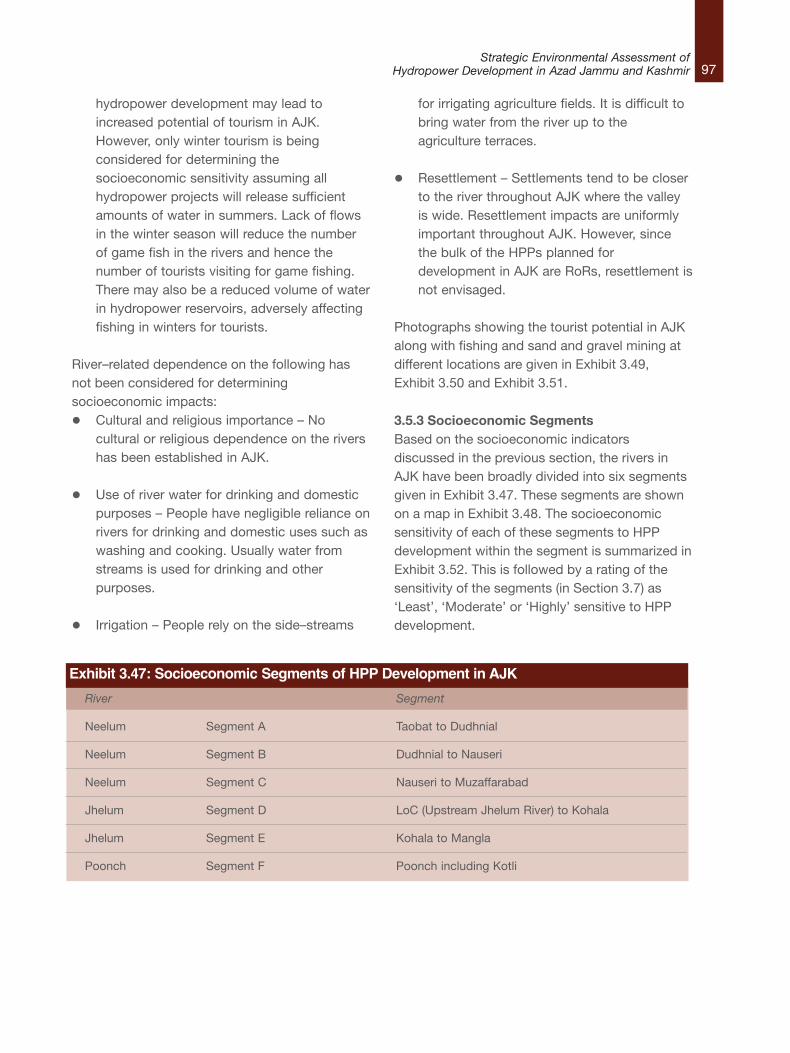
97Strategic Environmental Assessment of
Hydropower Development in Azad Jammu and Kashmir
hydropower development may lead toincreased potential of tourism in AJK.However, only winter tourism is beingconsidered for determining thesocioeconomic sensitivity assuming allhydropower projects will release sufficientamounts of water in summers. Lack of flowsin the winter season will reduce the numberof game fish in the rivers and hence thenumber of tourists visiting for game fishing.There may also be a reduced volume of waterin hydropower reservoirs, adversely affectingfishing in winters for tourists.
River–related dependence on the following hasnot been considered for determiningsocioeconomic impacts:l Cultural and religious importance – No
cultural or religious dependence on the rivershas been established in AJK.
l Use of river water for drinking and domesticpurposes – People have negligible reliance onrivers for drinking and domestic uses such aswashing and cooking. Usually water fromstreams is used for drinking and otherpurposes.
l Irrigation – People rely on the side–streams
for irrigating agriculture fields. It is difficult tobring water from the river up to theagriculture terraces.
l Resettlement – Settlements tend to be closerto the river throughout AJK where the valleyis wide. Resettlement impacts are uniformlyimportant throughout AJK. However, sincethe bulk of the HPPs planned fordevelopment in AJK are RoRs, resettlement isnot envisaged.
Photographs showing the tourist potential in AJKalong with fishing and sand and gravel mining atdifferent locations are given in Exhibit 3.49,Exhibit 3.50 and Exhibit 3.51.
3.5.3 Socioeconomic SegmentsBased on the socioeconomic indicatorsdiscussed in the previous section, the rivers inAJK have been broadly divided into six segmentsgiven in Exhibit 3.47. These segments are shownon a map in Exhibit 3.48. The socioeconomicsensitivity of each of these segments to HPPdevelopment within the segment is summarized inExhibit 3.52. This is followed by a rating of thesensitivity of the segments (in Section 3.7) as‘Least’, ‘Moderate’ or ‘Highly’ sensitive to HPPdevelopment.
Exhibit 3.47: Socioeconomic Segments of HPP Development in AJK
River Segment
Neelum Segment A Taobat to Dudhnial
Neelum Segment B Dudhnial to Nauseri
Neelum Segment C Nauseri to Muzaffarabad
Jhelum Segment D LoC (Upstream Jhelum River) to Kohala
Jhelum Segment E Kohala to Mangla
Poonch Segment F Poonch including Kotli
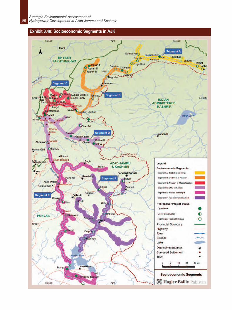
98Strategic Environmental Assessment ofHydropower Development in Azad Jammu and Kashmir
Exhibit 3.48: Socioeconomic Segments in AJK
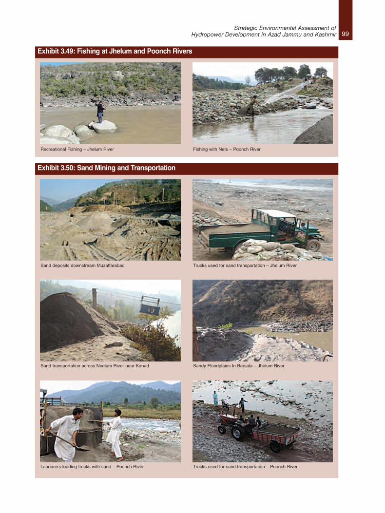
99Strategic Environmental Assessment of
Hydropower Development in Azad Jammu and Kashmir
Exhibit 3.49: Fishing at Jhelum and Poonch Rivers
Recreational Fishing – Jhelum River Fishing with Nets – Poonch River
Exhibit 3.50: Sand Mining and Transportation
Sand deposits downstream Muzaffarabad Trucks used for sand transportation – Jhelum River
Sand transportation across Neelum River near Kanad Sandy Floodplains In Barsala – Jhelum River
Labourers loading trucks with sand – Poonch River Trucks used for sand transportation – Poonch River
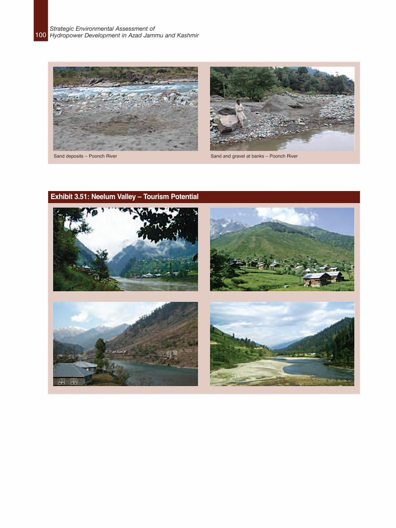
100Strategic Environmental Assessment ofHydropower Development in Azad Jammu and Kashmir
Sand deposits – Poonch River Sand and gravel at banks – Poonch River
Exhibit 3.51: Neelum Valley – Tourism Potential
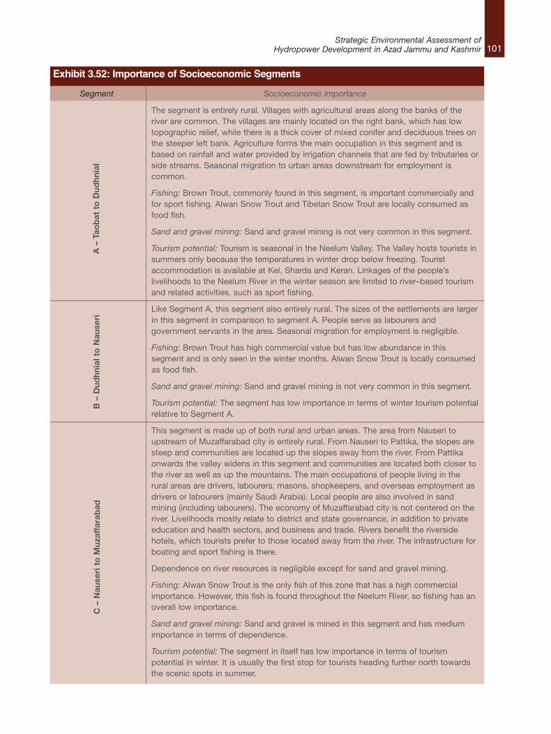
101Strategic Environmental Assessment of
Hydropower Development in Azad Jammu and Kashmir
Segment Socioeconomic Importance
The segment is entirely rural. Villages with agricultural areas along the banks of theriver are common. The villages are mainly located on the right bank, which has lowtopographic relief, while there is a thick cover of mixed conifer and deciduous trees onthe steeper left bank. Agriculture forms the main occupation in this segment and isbased on rainfall and water provided by irrigation channels that are fed by tributaries orside streams. Seasonal migration to urban areas downstream for employment iscommon.
Fishing: Brown Trout, commonly found in this segment, is important commercially andfor sport fishing. Alwan Snow Trout and Tibetan Snow Trout are locally consumed asfood fish.
Sand and gravel mining: Sand and gravel mining is not very common in this segment.
Tourism potential: Tourism is seasonal in the Neelum Valley. The Valley hosts tourists insummers only because the temperatures in winter drop below freezing. Touristaccommodation is available at Kel, Sharda and Keran. Linkages of the people’slivelihoods to the Neelum River in the winter season are limited to river–based tourismand related activities, such as sport fishing.
Like Segment A, this segment also entirely rural. The sizes of the settlements are largerin this segment in comparison to segment A. People serve as labourers andgovernment servants in the area. Seasonal migration for employment is negligible.
Fishing: Brown Trout has high commercial value but has low abundance in thissegment and is only seen in the winter months. Alwan Snow Trout is locally consumedas food fish.
Sand and gravel mining: Sand and gravel mining is not very common in this segment.
Tourism potential: The segment has low importance in terms of winter tourism potentialrelative to Segment A.
This segment is made up of both rural and urban areas. The area from Nauseri toupstream of Muzaffarabad city is entirely rural. From Nauseri to Pattika, the slopes aresteep and communities are located up the slopes away from the river. From Pattikaonwards the valley widens in this segment and communities are located both closer tothe river as well as up the mountains. The main occupations of people living in therural areas are drivers, labourers, masons, shopkeepers, and overseas employment asdrivers or labourers (mainly Saudi Arabia). Local people are also involved in sandmining (including labourers). The economy of Muzaffarabad city is not centered on theriver. Livelihoods mostly relate to district and state governance, in addition to privateeducation and health sectors, and business and trade. Rivers benefit the riversidehotels, which tourists prefer to those located away from the river. The infrastructure forboating and sport fishing is there.
Dependence on river resources is negligible except for sand and gravel mining.
Fishing: Alwan Snow Trout is the only fish of this zone that has a high commercialimportance. However, this fish is found throughout the Neelum River, so fishing has anoverall low importance.
Sand and gravel mining: Sand and gravel is mined in this segment and has mediumimportance in terms of dependence.
Tourism potential: The segment in itself has low importance in terms of tourismpotential in winter. It is usually the first stop for tourists heading further north towardsthe scenic spots in summer.
Exhibit 3.52: Importance of Socioeconomic Segments
A – Taobat to Dudhnial
B – Dudhnial to Nauseri
C – Nauseri to Muzaffarabad
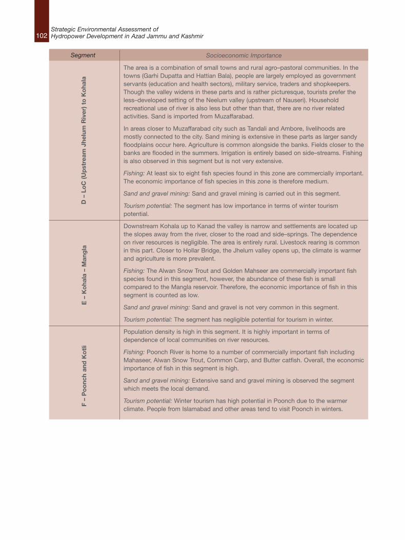
102Strategic Environmental Assessment ofHydropower Development in Azad Jammu and Kashmir
Socioeconomic Importance
The area is a combination of small towns and rural agro–pastoral communities. In thetowns (Garhi Dupatta and Hattian Bala), people are largely employed as governmentservants (education and health sectors), military service, traders and shopkeepers.Though the valley widens in these parts and is rather picturesque, tourists prefer theless–developed setting of the Neelum valley (upstream of Nauseri). Householdrecreational use of river is also less but other than that, there are no river relatedactivities. Sand is imported from Muzaffarabad.
In areas closer to Muzaffarabad city such as Tandali and Ambore, livelihoods aremostly connected to the city. Sand mining is extensive in these parts as larger sandyfloodplains occur here. Agriculture is common alongside the banks. Fields closer to thebanks are flooded in the summers. Irrigation is entirely based on side–streams. Fishingis also observed in this segment but is not very extensive.
Fishing: At least six to eight fish species found in this zone are commercially important.The economic importance of fish species in this zone is therefore medium.
Sand and gravel mining: Sand and gravel mining is carried out in this segment.
Tourism potential: The segment has low importance in terms of winter tourismpotential.
Downstream Kohala up to Kanad the valley is narrow and settlements are located upthe slopes away from the river, closer to the road and side–springs. The dependenceon river resources is negligible. The area is entirely rural. Livestock rearing is commonin this part. Closer to Hollar Bridge, the Jhelum valley opens up, the climate is warmerand agriculture is more prevalent.
Fishing: The Alwan Snow Trout and Golden Mahseer are commercially important fishspecies found in this segment, however, the abundance of these fish is smallcompared to the Mangla reservoir. Therefore, the economic importance of fish in thissegment is counted as low.
Sand and gravel mining: Sand and gravel is not very common in this segment.
Tourism potential: The segment has negligible potential for tourism in winter.
Population density is high in this segment. It is highly important in terms ofdependence of local communities on river resources.
Fishing: Poonch River is home to a number of commercially important fish includingMahaseer, Alwan Snow Trout, Common Carp, and Butter catfish. Overall, the economicimportance of fish in this segment is high.
Sand and gravel mining: Extensive sand and gravel mining is observed the segmentwhich meets the local demand.
Tourism potential: Winter tourism has high potential in Poonch due to the warmerclimate. People from Islamabad and other areas tend to visit Poonch in winters.
D – LoC (Upstream
Jhelum River) to Kohala
E – Kohala – Mangla
F – Poonch and Kotli
Segment
103Strategic Environmental Assessment of
Hydropower Development in Azad Jammu and Kashmir
3.5.4 Sensitivity Rating
This section assesses the sensitivity of each
segment to hydropower development keeping in
the following indicators which were introduced in
the previous section:
l Fishing (commercial, subsistence,
recreational);
l Sand and gravel mining; and
l Tourism Potential.
First, each indicator is “scored” for each of the six
segments, according to the impact of proposed
HPPs. The outcome of this scoring exercise is
presented in Exhibit 3.53. An indicator is given a
score of “1” if impacts are likely to be low, “2” if
medium, and “3” if high.
The Total Socioeconomic Assessment Score
(TSAS) for each segment is then calculated by
adding the scores for each of the three indicators.
The following system is used to make the final
assessment regarding the sensitivity of the each
segment to hydropower development:
Least Sensitivity Zone – Total Assessment
Score of 1 – 3.
Moderate Sensitivity Zone – Total Assessment
Score of 4 – 6.
High Sensitivity Zone – Total Assessment
Score of 7 – 9.
The socioeconomic sensitivity rating of each
segment is shown in Exhibit 3.53 and the mapped
sensitivity zones are shown in Exhibit 3.54.
River
Neelum
Neelum
Neelum
Jhelum
Jhelum
Poonch
Segment
Segment A
Segment B
Segment C
Segment D
Segment E
Segment F
SocioeconomicSegment
Taobat to Dhudnial
Dhudnial to Nauseri
Nauseri toMuzaffarabad
LoC (Upstream ofJhelum River) toKohala
Kohala to Mangla
Poonch includingKotli
Fishing(commercial,subsistence,recreational)
High
Low
Low
Medium
Medium
High
Sand andGravelMining
Low
Low
Medium
Medium
Low
High
TourismPotential
Low
Low
Low
Low
Low
High
SocioeconomicAssessment
Score
5
3
4
6
4
9
SensitivityClassification
ModeratelySensitive
LeastSensitive
ModeratelySensitive
ModeratelySensitive
ModeratelySensitive
HighlySensitive
Exhibit 3.53: Socioeconomic Sensitivity of Segments for Hydropower Development
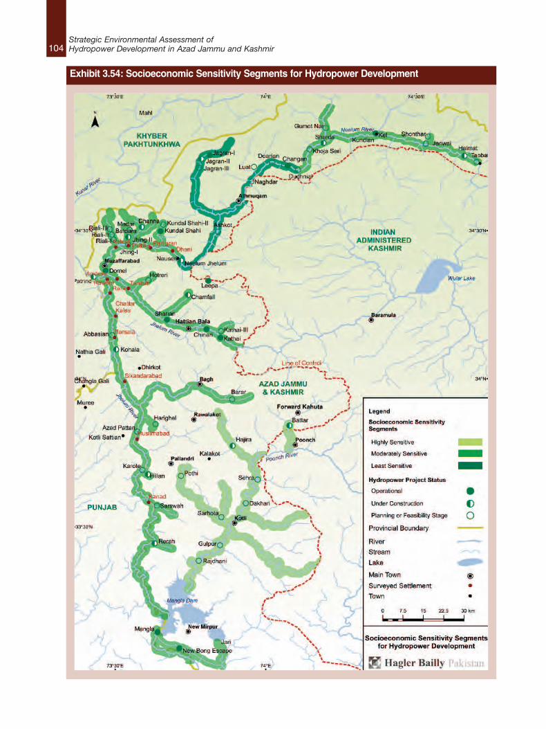
104Strategic Environmental Assessment ofHydropower Development in Azad Jammu and Kashmir
Exhibit 3.54: Socioeconomic Sensitivity Segments for Hydropower Development
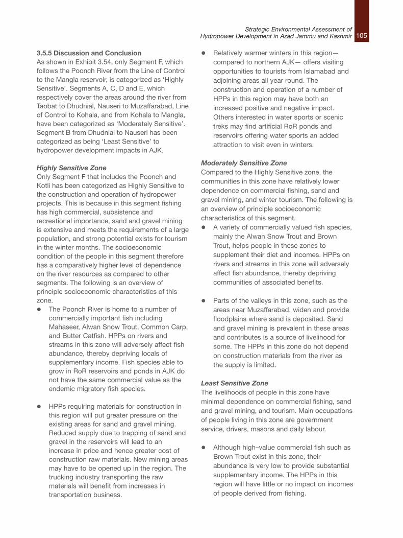
105Strategic Environmental Assessment of
Hydropower Development in Azad Jammu and Kashmir
3.5.5 Discussion and ConclusionAs shown in Exhibit 3.54, only Segment F, whichfollows the Poonch River from the Line of Controlto the Mangla reservoir, is categorized as ‘HighlySensitive’. Segments A, C, D and E, whichrespectively cover the areas around the river fromTaobat to Dhudnial, Nauseri to Muzaffarabad, Lineof Control to Kohala, and from Kohala to Mangla,have been categorized as ‘Moderately Sensitive’.Segment B from Dhudnial to Nauseri has beencategorized as being ‘Least Sensitive’ tohydropower development impacts in AJK.
Highly Sensitive ZoneOnly Segment F that includes the Poonch andKotli has been categorized as Highly Sensitive tothe construction and operation of hydropowerprojects. This is because in this segment fishinghas high commercial, subsistence andrecreational importance, sand and gravel miningis extensive and meets the requirements of a largepopulation, and strong potential exists for tourismin the winter months. The socioeconomiccondition of the people in this segment thereforehas a comparatively higher level of dependenceon the river resources as compared to othersegments. The following is an overview ofprinciple socioeconomic characteristics of thiszone.l The Poonch River is home to a number of
commercially important fish includingMahaseer, Alwan Snow Trout, Common Carp,and Butter Catfish. HPPs on rivers andstreams in this zone will adversely affect fishabundance, thereby depriving locals ofsupplementary income. Fish species able togrow in RoR reservoirs and ponds in AJK donot have the same commercial value as theendemic migratory fish species.
l HPPs requiring materials for construction inthis region will put greater pressure on theexisting areas for sand and gravel mining.Reduced supply due to trapping of sand andgravel in the reservoirs will lead to anincrease in price and hence greater cost ofconstruction raw materials. New mining areasmay have to be opened up in the region. Thetrucking industry transporting the rawmaterials will benefit from increases intransportation business.
l Relatively warmer winters in this region—compared to northern AJK— offers visitingopportunities to tourists from Islamabad andadjoining areas all year round. Theconstruction and operation of a number ofHPPs in this region may have both anincreased positive and negative impact.Others interested in water sports or scenictreks may find artificial RoR ponds andreservoirs offering water sports an addedattraction to visit even in winters.
Moderately Sensitive ZoneCompared to the Highly Sensitive zone, thecommunities in this zone have relatively lowerdependence on commercial fishing, sand andgravel mining, and winter tourism. The following isan overview of principle socioeconomiccharacteristics of this segment.l A variety of commercially valued fish species,
mainly the Alwan Snow Trout and BrownTrout, helps people in these zones tosupplement their diet and incomes. HPPs onrivers and streams in this zone will adverselyaffect fish abundance, thereby deprivingcommunities of associated benefits.
l Parts of the valleys in this zone, such as theareas near Muzaffarabad, widen and providefloodplains where sand is deposited. Sandand gravel mining is prevalent in these areasand contributes is a source of livelihood forsome. The HPPs in this zone do not dependon construction materials from the river asthe supply is limited.
Least Sensitive ZoneThe livelihoods of people in this zone haveminimal dependence on commercial fishing, sandand gravel mining, and tourism. Main occupationsof people living in this zone are governmentservice, drivers, masons and daily labour.
l Although high–value commercial fish such asBrown Trout exist in this zone, theirabundance is very low to provide substantialsupplementary income. The HPPs in thisregion will have little or no impact on incomesof people derived from fishing.
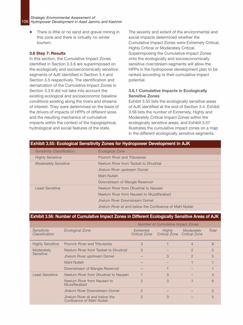
106Strategic Environmental Assessment ofHydropower Development in Azad Jammu and Kashmir
l There is little or no sand and gravel mining inthis zone and there is virtually no wintertourism.
3.6 Step 7: ResultsIn this section, the Cumulative Impact Zonesidentified in Section 3.3.6 are superimposed onthe ecologically and socioeconomically sensitivesegments of AJK identified in Section 3.4 andSection 3.5 respectively. The identification anddemarcation of the Cumulative Impact Zones inSection 3.3.6 did not take into account theexisting ecological and socioeconomic baselineconditions existing along the rivers and streamsof interest. They were determined on the basis ofthe drivers of impacts of HPPs of different sizesand the resulting mechanics of cumulativeimpacts within the context of the topographical,hydrological and social features of the state.
The severity and extent of the environmental andsocial impacts determined whether theCumulative Impact Zones were Extremely Critical,Highly Critical or Moderately Critical. Superimposing the Cumulative Impact Zonesonto the ecologically and socioeconomicallysensitive river/stream segments will allow theHPPs in the hydropower development plan to beranked according to their cumulative impactpotential.
3.6.1 Cumulative Impacts in EcologicallySensitive ZonesExhibit 3.55 lists the ecologically sensitive areasof AJK identified at the end of Section 3.4. Exhibit3.56 lists the number of Extremely, Highly andModerately Critical Impact Zones within theecologically sensitive areas, and Exhibit 3.57illustrates the cumulative impact zones on a mapin the different ecologically sensitive segments.
Exhibit 3.55: Ecological Sensitivity Zones for Hydropower Development in AJK
Sensitivity Classification Ecological Zone
Highly Sensitive Poonch River and Tributaries
Moderately Sensitive Neelum River from Taobat to Dhudnial
Jhelum River upstream Domel
Mahl Nullah
Downstream of Mangla Reservoir
Least Sensitive Neelum River from Dhudnial to Nauseri
Neelum River from Nauseri to Muzaffarabad
Jhelum River Downstream Domel
Jhelum River at and below the Confluence of Mahl Nullah
Exhibit 3.56: Number of Cumulative Impact Zones in Different Ecologically Sensitive Areas of AJK
SensitivityClassification
Highly Sensitive
ModeratelySensitive
Least Sensitive
Number of Cumulative Impact Zones
Ecological Zone
Poonch River and Tributaries
Neelum River from Taobat to Dhudnial
Jhelum River upstream Domel
Mahl Nullah
Downstream of Mangla Reservoir
Neelum River from Dhudnial to Nauseri
Neelum River from Nauseri toMuzaffarabad
Jhelum River Downstream Domel
Jhelum River at and below theConfluence of Mahl Nullah
ExtremelyCritical Zone
3
3
–
–
–
1
2
2
2
HighlyCritical Zone
1
–
3
–
1
3
3
–
3
ModeratelyCritical Zone
4
2
2
1
–
–
1
–
–
Total
8
5
5
1
1
4
6
2
5
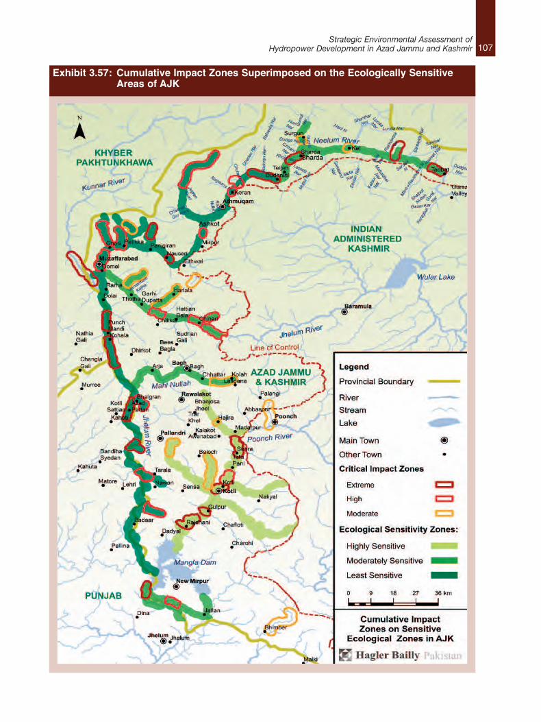
107Strategic Environmental Assessment of
Hydropower Development in Azad Jammu and Kashmir
Exhibit 3.57: Cumulative Impact Zones Superimposed on the Ecologically Sensitive Areas of AJK
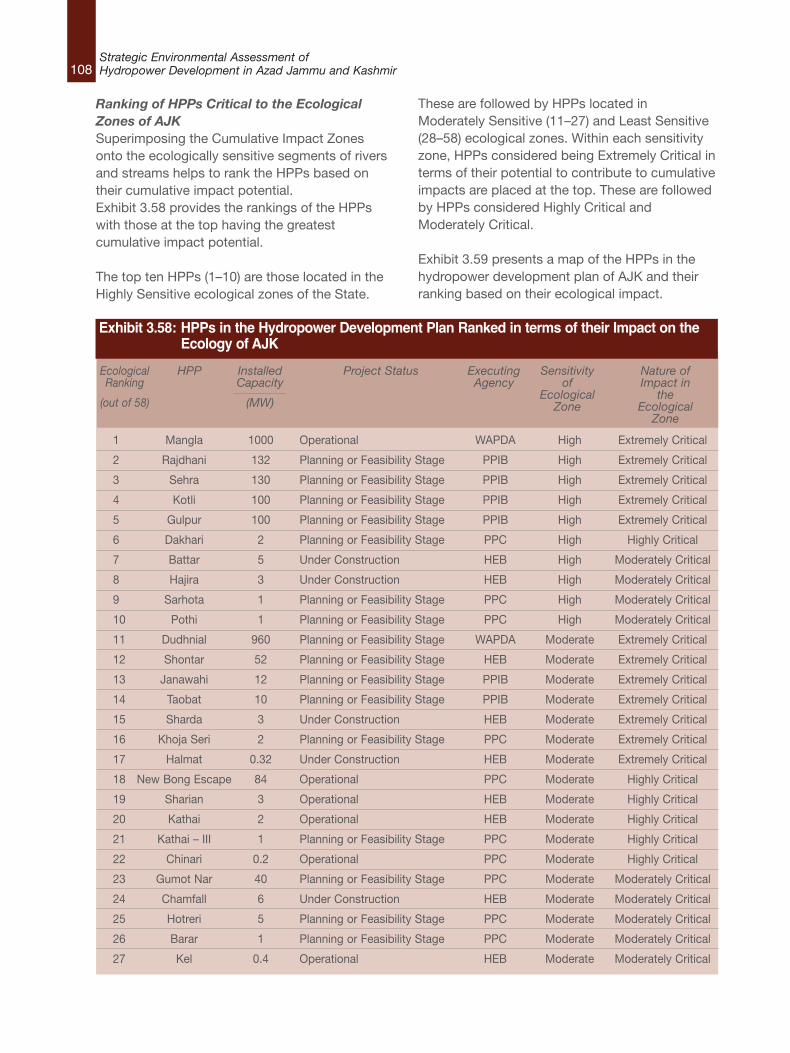
108Strategic Environmental Assessment ofHydropower Development in Azad Jammu and Kashmir
Ranking of HPPs Critical to the EcologicalZones of AJKSuperimposing the Cumulative Impact Zonesonto the ecologically sensitive segments of riversand streams helps to rank the HPPs based ontheir cumulative impact potential.Exhibit 3.58 provides the rankings of the HPPswith those at the top having the greatestcumulative impact potential.
The top ten HPPs (1–10) are those located in theHighly Sensitive ecological zones of the State.
These are followed by HPPs located inModerately Sensitive (11–27) and Least Sensitive(28–58) ecological zones. Within each sensitivityzone, HPPs considered being Extremely Critical interms of their potential to contribute to cumulativeimpacts are placed at the top. These are followedby HPPs considered Highly Critical andModerately Critical.
Exhibit 3.59 presents a map of the HPPs in thehydropower development plan of AJK and theirranking based on their ecological impact.
1 Mangla 1000 Operational WAPDA High Extremely Critical
2 Rajdhani 132 Planning or Feasibility Stage PPIB High Extremely Critical
3 Sehra 130 Planning or Feasibility Stage PPIB High Extremely Critical
4 Kotli 100 Planning or Feasibility Stage PPIB High Extremely Critical
5 Gulpur 100 Planning or Feasibility Stage PPIB High Extremely Critical
6 Dakhari 2 Planning or Feasibility Stage PPC High Highly Critical
7 Battar 5 Under Construction HEB High Moderately Critical
8 Hajira 3 Under Construction HEB High Moderately Critical
9 Sarhota 1 Planning or Feasibility Stage PPC High Moderately Critical
10 Pothi 1 Planning or Feasibility Stage PPC High Moderately Critical
11 Dudhnial 960 Planning or Feasibility Stage WAPDA Moderate Extremely Critical
12 Shontar 52 Planning or Feasibility Stage HEB Moderate Extremely Critical
13 Janawahi 12 Planning or Feasibility Stage PPIB Moderate Extremely Critical
14 Taobat 10 Planning or Feasibility Stage PPIB Moderate Extremely Critical
15 Sharda 3 Under Construction HEB Moderate Extremely Critical
16 Khoja Seri 2 Planning or Feasibility Stage PPC Moderate Extremely Critical
17 Halmat 0.32 Under Construction HEB Moderate Extremely Critical
18 New Bong Escape 84 Operational PPC Moderate Highly Critical
19 Sharian 3 Operational HEB Moderate Highly Critical
20 Kathai 2 Operational HEB Moderate Highly Critical
21 Kathai – III 1 Planning or Feasibility Stage PPC Moderate Highly Critical
22 Chinari 0.2 Operational PPC Moderate Highly Critical
23 Gumot Nar 40 Planning or Feasibility Stage PPC Moderate Moderately Critical
24 Chamfall 6 Under Construction HEB Moderate Moderately Critical
25 Hotreri 5 Planning or Feasibility Stage PPC Moderate Moderately Critical
26 Barar 1 Planning or Feasibility Stage PPC Moderate Moderately Critical
27 Kel 0.4 Operational HEB Moderate Moderately Critical
EcologicalRanking
(out of 58)
HPP InstalledCapacity
(MW)
Project Status ExecutingAgency
Sensitivityof
EcologicalZone
Nature ofImpact in
theEcological
Zone
Exhibit 3.58: HPPs in the Hydropower Development Plan Ranked in terms of their Impact on the Ecology of AJK
109Strategic Environmental Assessment of
Hydropower Development in Azad Jammu and Kashmir
28 Kohala 1100 Planning or Feasibility Stage PPIB Least Extremely Critical
29 Neelum–Jhelum 969 Under Construction WAPDA Least Extremely Critical
30 Karote 720 Planning or Feasibility Stage PPIB Least Extremely Critical
31 Abbasian 360 Planning or Feasibility Stage PPIB Least Extremely Critical
32 Azad Pattan 222 Planning or Feasibility Stage PPIB Least Extremely Critical
33 Patrind 147 Under Construction PPIB Least Extremely Critical
34 Dowarian 40 Planning or Feasibility Stage HEB Least Extremely Critical
35 Changan–II 9 Planning or Feasibility Stage PPIB Least Extremely Critical
36 Hillan 1 Under Construction HEB Least Extremely Critical
37 Changan 0.05 Operational HEB Least Extremely Critical
38 Luat 63 Planning or Feasibility Stage HEB Least Highly Critical
39 Harighel 53 Planning or Feasibility Stage PPIB Least Highly Critical
40 Jagran– II 44 Under Construction HEB Least Highly Critical
41 Ashkot 40 Planning or Feasibility Stage PPC Least Highly Critical
42 Nagdar 35 Planning or Feasibility Stage HEB Least Highly Critical
43 Jagran–III 35 Planning or Feasibility Stage PPC Least Highly Critical
44 Jagran – I 30 Operational HEB Least Highly Critical
45 Jhing – I 14 Under Construction HEB Least Highly Critical
46 Madar Batdara 10 Planning or Feasibility Stage PPC Least Highly Critical
47 Riali–II 5 Planning or Feasibility Stage PPC Least Highly Critical
48 Jhing – II 4 Planning or Feasibility Stage PPC Least Highly Critical
49 Riali – III 4 Planning or Feasibility Stage PPC Least Highly Critical
50 Rerah 3 Under Construction HEB Least Highly Critical
51 Riali–I 2 Planning or Feasibility Stage PPC Least Highly Critical
52 Sarswah 1 Planning or Feasibility Stage PPC Least Highly Critical
53 Patikka 0.05 Operational HEB Least Highly Critical
54 Kundal Shahi – II 600 Planning or Feasibility Stage WAPDA Least Moderately Critical
55 Kundal Shahi 2 Operational HEB Least Moderately Critical
56 Dhanna 2 Under Construction HEB Least Moderately Critical
57 Leepa 2 Operational HEB Least Moderately Critical
58 Samani 2 Planning or Feasibility Stage PPC Least Moderately Critical
EcologicalRanking
(out of 58)
HPP InstalledCapacity
(MW)
Project Status ExecutingAgency
Sensitivityof
EcologicalZone
Nature ofImpact in
theEcological
Zone
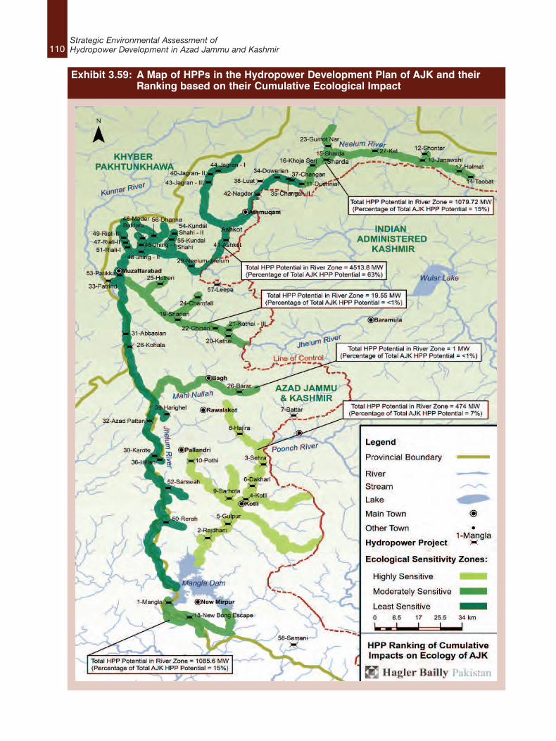
110Strategic Environmental Assessment ofHydropower Development in Azad Jammu and Kashmir
Exhibit 3.59: A Map of HPPs in the Hydropower Development Plan of AJK and their Ranking based on their Cumulative Ecological Impact
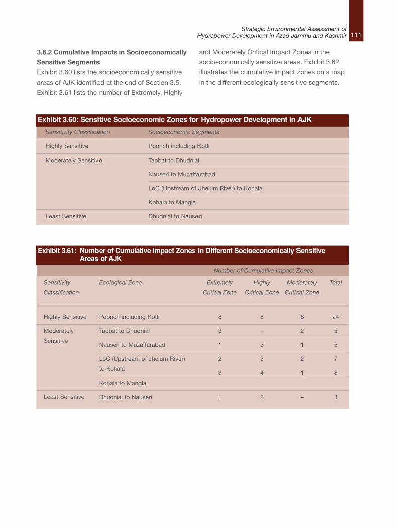
111Strategic Environmental Assessment of
Hydropower Development in Azad Jammu and Kashmir
3.6.2 Cumulative Impacts in Socioeconomically
Sensitive Segments
Exhibit 3.60 lists the socioeconomically sensitive
areas of AJK identified at the end of Section 3.5.
Exhibit 3.61 lists the number of Extremely, Highly
and Moderately Critical Impact Zones in the
socioeconomically sensitive areas. Exhibit 3.62
illustrates the cumulative impact zones on a map
in the different ecologically sensitive segments.
Exhibit 3.60: Sensitive Socioeconomic Zones for Hydropower Development in AJK
Sensitivity Classification Socioeconomic Segments
Highly Sensitive Poonch including Kotli
Moderately Sensitive Taobat to Dhudnial
Nauseri to Muzaffarabad
LoC (Upstream of Jhelum River) to Kohala
Kohala to Mangla
Least Sensitive Dhudnial to Nauseri
Sensitivity
Classification
Highly Sensitive
Moderately
Sensitive
Least Sensitive
Number of Cumulative Impact Zones
Ecological Zone
Poonch including Kotli
Taobat to Dhudnial
Nauseri to Muzaffarabad
LoC (Upstream of Jhelum River)
to Kohala
Kohala to Mangla
Dhudnial to Nauseri
Extremely
Critical Zone
8
3
1
2
3
1
Highly
Critical Zone
8
–
3
3
4
2
Moderately
Critical Zone
8
2
1
2
1
–
Total
24
5
5
7
8
3
Exhibit 3.61: Number of Cumulative Impact Zones in Different Socioeconomically SensitiveAreas of AJK
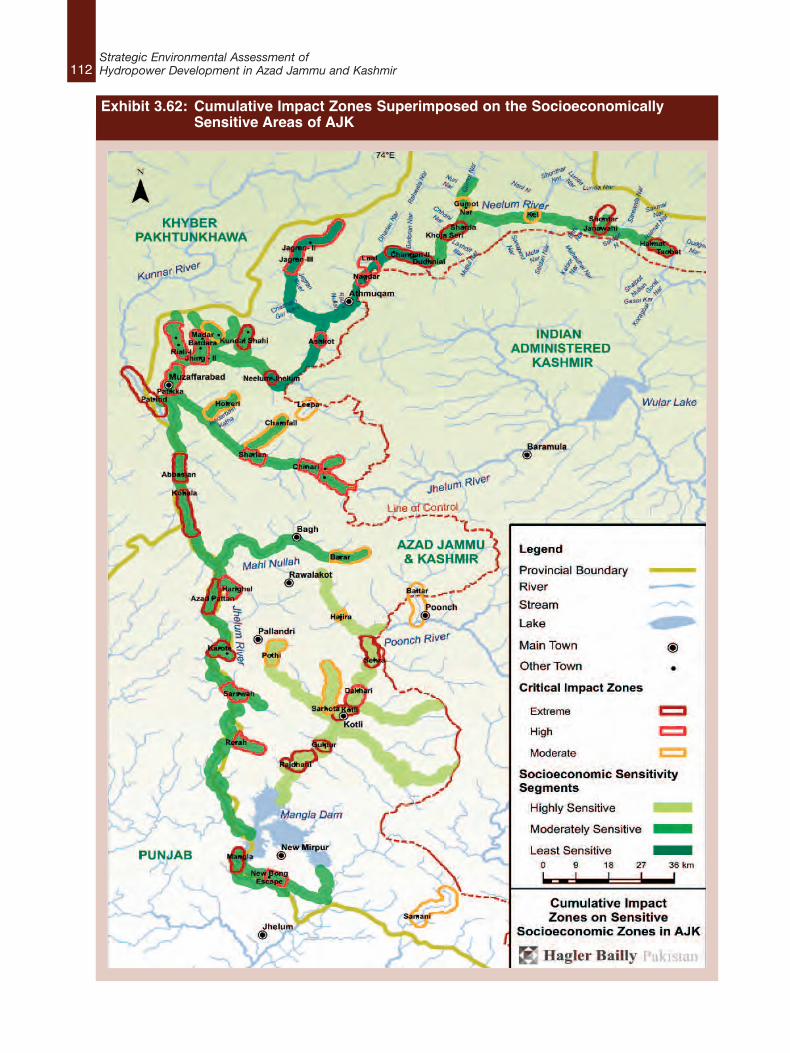
112Strategic Environmental Assessment ofHydropower Development in Azad Jammu and Kashmir
Exhibit 3.62: Cumulative Impact Zones Superimposed on the Socioeconomically Sensitive Areas of AJK
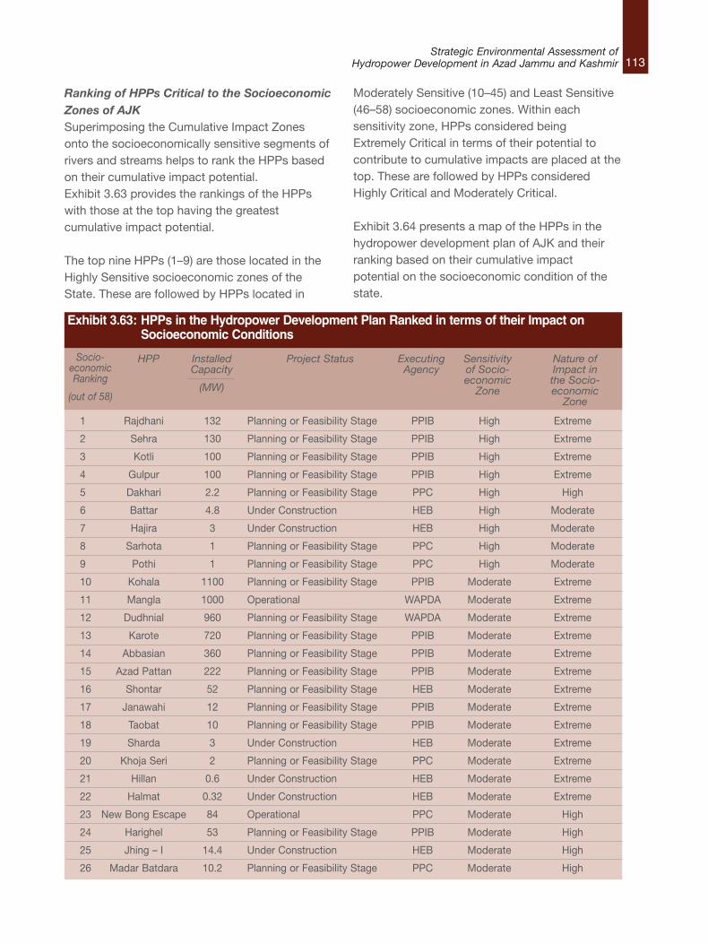
113Strategic Environmental Assessment of
Hydropower Development in Azad Jammu and Kashmir
Ranking of HPPs Critical to the SocioeconomicZones of AJKSuperimposing the Cumulative Impact Zonesonto the socioeconomically sensitive segments ofrivers and streams helps to rank the HPPs basedon their cumulative impact potential.Exhibit 3.63 provides the rankings of the HPPswith those at the top having the greatestcumulative impact potential.
The top nine HPPs (1–9) are those located in theHighly Sensitive socioeconomic zones of theState. These are followed by HPPs located in
Moderately Sensitive (10–45) and Least Sensitive(46–58) socioeconomic zones. Within eachsensitivity zone, HPPs considered beingExtremely Critical in terms of their potential tocontribute to cumulative impacts are placed at thetop. These are followed by HPPs consideredHighly Critical and Moderately Critical.
Exhibit 3.64 presents a map of the HPPs in thehydropower development plan of AJK and theirranking based on their cumulative impactpotential on the socioeconomic condition of thestate.
1 Rajdhani 132 Planning or Feasibility Stage PPIB High Extreme
2 Sehra 130 Planning or Feasibility Stage PPIB High Extreme
3 Kotli 100 Planning or Feasibility Stage PPIB High Extreme
4 Gulpur 100 Planning or Feasibility Stage PPIB High Extreme
5 Dakhari 2.2 Planning or Feasibility Stage PPC High High
6 Battar 4.8 Under Construction HEB High Moderate
7 Hajira 3 Under Construction HEB High Moderate
8 Sarhota 1 Planning or Feasibility Stage PPC High Moderate
9 Pothi 1 Planning or Feasibility Stage PPC High Moderate
10 Kohala 1100 Planning or Feasibility Stage PPIB Moderate Extreme
11 Mangla 1000 Operational WAPDA Moderate Extreme
12 Dudhnial 960 Planning or Feasibility Stage WAPDA Moderate Extreme
13 Karote 720 Planning or Feasibility Stage PPIB Moderate Extreme
14 Abbasian 360 Planning or Feasibility Stage PPIB Moderate Extreme
15 Azad Pattan 222 Planning or Feasibility Stage PPIB Moderate Extreme
16 Shontar 52 Planning or Feasibility Stage HEB Moderate Extreme
17 Janawahi 12 Planning or Feasibility Stage PPIB Moderate Extreme
18 Taobat 10 Planning or Feasibility Stage PPIB Moderate Extreme
19 Sharda 3 Under Construction HEB Moderate Extreme
20 Khoja Seri 2 Planning or Feasibility Stage PPC Moderate Extreme
21 Hillan 0.6 Under Construction HEB Moderate Extreme
22 Halmat 0.32 Under Construction HEB Moderate Extreme
23 New Bong Escape 84 Operational PPC Moderate High
24 Harighel 53 Planning or Feasibility Stage PPIB Moderate High
25 Jhing – I 14.4 Under Construction HEB Moderate High
26 Madar Batdara 10.2 Planning or Feasibility Stage PPC Moderate High
Socio-economicRanking
(out of 58)
HPP InstalledCapacity
(MW)
Project Status ExecutingAgency
Sensitivityof Socio-economicZone
Nature ofImpact inthe Socio-economicZone
Exhibit 3.63: HPPs in the Hydropower Development Plan Ranked in terms of their Impact on Socioeconomic Conditions
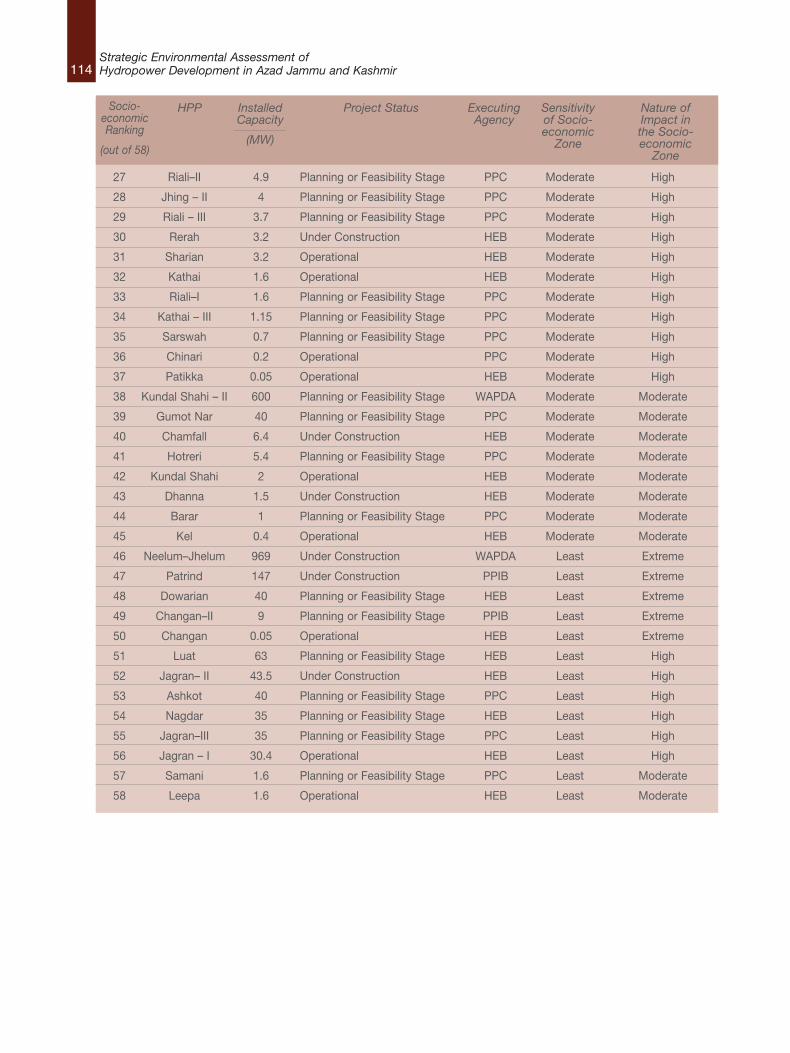
114Strategic Environmental Assessment ofHydropower Development in Azad Jammu and Kashmir
27 Riali–II 4.9 Planning or Feasibility Stage PPC Moderate High
28 Jhing – II 4 Planning or Feasibility Stage PPC Moderate High
29 Riali – III 3.7 Planning or Feasibility Stage PPC Moderate High
30 Rerah 3.2 Under Construction HEB Moderate High
31 Sharian 3.2 Operational HEB Moderate High
32 Kathai 1.6 Operational HEB Moderate High
33 Riali–I 1.6 Planning or Feasibility Stage PPC Moderate High
34 Kathai – III 1.15 Planning or Feasibility Stage PPC Moderate High
35 Sarswah 0.7 Planning or Feasibility Stage PPC Moderate High
36 Chinari 0.2 Operational PPC Moderate High
37 Patikka 0.05 Operational HEB Moderate High
38 Kundal Shahi – II 600 Planning or Feasibility Stage WAPDA Moderate Moderate
39 Gumot Nar 40 Planning or Feasibility Stage PPC Moderate Moderate
40 Chamfall 6.4 Under Construction HEB Moderate Moderate
41 Hotreri 5.4 Planning or Feasibility Stage PPC Moderate Moderate
42 Kundal Shahi 2 Operational HEB Moderate Moderate
43 Dhanna 1.5 Under Construction HEB Moderate Moderate
44 Barar 1 Planning or Feasibility Stage PPC Moderate Moderate
45 Kel 0.4 Operational HEB Moderate Moderate
46 Neelum–Jhelum 969 Under Construction WAPDA Least Extreme
47 Patrind 147 Under Construction PPIB Least Extreme
48 Dowarian 40 Planning or Feasibility Stage HEB Least Extreme
49 Changan–II 9 Planning or Feasibility Stage PPIB Least Extreme
50 Changan 0.05 Operational HEB Least Extreme
51 Luat 63 Planning or Feasibility Stage HEB Least High
52 Jagran– II 43.5 Under Construction HEB Least High
53 Ashkot 40 Planning or Feasibility Stage PPC Least High
54 Nagdar 35 Planning or Feasibility Stage HEB Least High
55 Jagran–III 35 Planning or Feasibility Stage PPC Least High
56 Jagran – I 30.4 Operational HEB Least High
57 Samani 1.6 Planning or Feasibility Stage PPC Least Moderate
58 Leepa 1.6 Operational HEB Least Moderate
Socio-economicRanking
(out of 58)
HPP InstalledCapacity
(MW)
Project Status ExecutingAgency
Sensitivityof Socio-economicZone
Nature ofImpact inthe Socio-economicZone
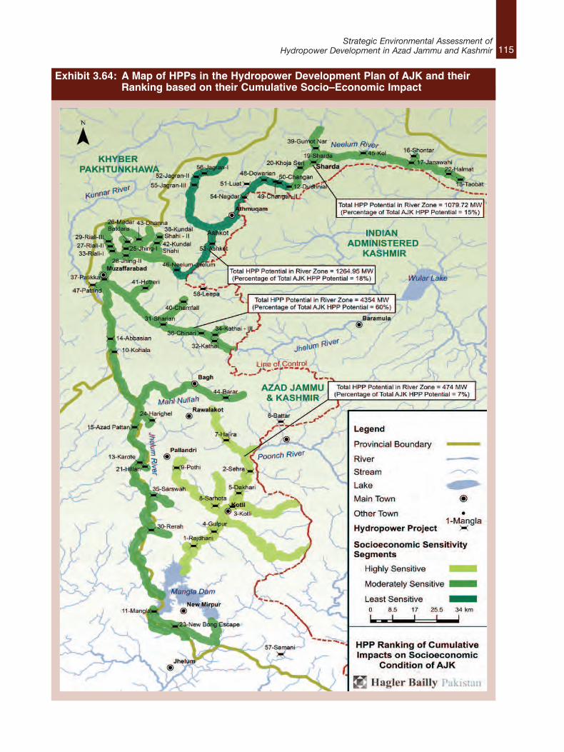
115Strategic Environmental Assessment of
Hydropower Development in Azad Jammu and Kashmir
Exhibit 3.64: A Map of HPPs in the Hydropower Development Plan of AJK and their Ranking based on their Cumulative Socio–Economic Impact
116Strategic Environmental Assessment ofHydropower Development in Azad Jammu and Kashmir
3.6.3 Conclusions Summary of the Study MethodologyTo reiterate, the final ranking of HPPs accordingto their cumulative impact potential wasundertaken using the following procedural steps:l a division of HPPs against a 50 MW
benchmark, set as a result of an analysis ofthe layout and structural components of sixHPPs, and identification of the main driversof impacts;
l identification of the environmental and socialimpacts of HPPs relevant to the hydrological,topographical and socioeconomic context;
l identification of Cumulative Impact Zonesbased on the location of HPPs on nullahs ormain river stems;
l categorization of the Cumulative ImpactZones based on the extent and magnitude ofthe impacts of a number of HPPs in differentparts of the river systems;
l identification and categorization of sensitiveecological zones;
l identification and categorization of sensitivesocioeconomic zones; and,
l ranking HPPs in terms of their potentialcumulative impacts on the existing ecologyand socioeconomic condition of the State.
The ranking of an HPP based on theseprocedures enables the proponents of the project,environmental consultants, state agencies andAJKEPA to identify, at a glance;l the overall existing ecological and
socioeconomic picture of the area where aHPP is being planned for development orcurrently in the process of being constructedand the regions where more detailed studiesneed to be prioritized;
l the scale of the impact an HPP will have onthe ecology and socioeconomic condition ofthe area where it will be located;
l the contribution of an HPP to the overallcumulative impacts from the development ofall the HPPs in the plan;
l the potential need for a change of qualifyingconditions for either EIA or IEE studies fordifferent HPPs, and the detail in which theecological and socioeconomic impactassessment studies need to be conducted forprojects based on their location;
l the role and significance of coordinationbetween HEB, PPC, WAPDA, PPIB andAJKEPA in developing the hydropower plan ina manner which minimizes impacts;
l an opportunity for revising the Plan as awhole or revising the type, size, layout andstructural components of a HPP to utilize anybenefit from other HPPs being built in thevicinity; and,
l the regions in AJK where public awarenesscampaigns need to be organized by thegovernment to help monitor HPPs during theconstruction and operation phases.
Outcomes of the HPP RankingA clear outcome from the cumulative impactassessment is that the area of most concern, bothfrom ecological and socio–economicperspectives, is the Poonch River and its feed–innullahs from the Line of Control down to theMangla Dam. The nine proposed HPPs all rankhighest for potential ecological and social impact.As indicated in Exhibits 3.58 and 3.63, however, itshould be noted that the Poonch River segmentonly accounts for 7% of the total AJK hydropowergeneration potential.
Section 4 of this final report examines theimplications of the cumulative impact assessmentoutcomes for decision–making.

117Strategic Environmental Assessment of
Hydropower Development in Azad Jammu and Kashmir
4.1 IntroductionPhase 3 of the SEA pilot presented recommendations for institutional reformthat will allow overall hydropower planning for AJK to be improved. Thefollowing recommendations focus on: clarifying responsibilities for hydropowerplan ownership; improving project development planning; guidelines forenvironmental impact assessment; and, proposing minor regulatoryamendments.
4.2 Clarifying Responsibilities for Plan OwnershipSection 2 of this final report described, in detail, existing and proposedhydropower projects. According to the latest information available from all thegovernment agencies involved in hydropower development in AJK, there arecurrently 12 operational hydropower projects in the state; an additional 13 areunder construction while 37 more sites have been identified for detailedfeasibility studies.
In order to exploit the plentiful hydel resources of the State, the Government ofAJK (GoAJK) established the AJK Hydro Electric Board (HEB) in 1989 to planand undertake development of identified hydro potential, and implementpublic sector hydropower projects. Subsequently, with the intention ofproviding a ‘one–window’ facility and to encourage the development of hydelpotential in the private sector, the GoAJK created the AJK Private Power Cell(PPC) in 1995.
HEB and PPC are the two government agencies in AJK that are responsible forthe implementation of hydropower projects in AJK with capacities up to 50MW. This is in accordance with the power policy of 2002 which madeprovinces and the State of AJK responsible for managing the development andimplementation of power projects with capacities up to 50 MW leaving thefederal agencies, namely WAPDA – for public sector projects – and PPIB – forprivate sector projects – to manage hydropower projects in AJK withcapacities greater than 50 MW.
Early in the preparation of Phase 1, it became clear that there is no singleunified hydropower development plan for AJK. While important policiesgoverning overall hydropower development such as the Policy for Power
4. Phase 3: Informing Decision–making
118Strategic Environmental Assessment ofHydropower Development in Azad Jammu and Kashmir
Generation Projects (2002)51 and Vision 202552
exist, they are not specifically targeted at theState. Only some aspects of these policies havebeen adapted for application in AJK which focusprimarily on the remit of the agency thatdeveloped them. In addition, these are policies,rather than plans, and therefore provide littleinformation on proposed infrastructuredevelopments.
What does exist at the level of infrastructure plansare forward development proposals generated byeach of the four agencies. These were providedduring Phase 1, and they provide the basis for theconsolidated list of projects outlined in Section3.2 of this final report. It is important to note,however, that these plans are developed inisolation by the agencies in question. There doesnot appear to be any attempt to coordinate thedevelopment of these plans.
The negative environmental and socialconsequences of this disjointed approach areclear. For example, it is not possible to easilyrevise the whole hydropower plan to minimizenegative impacts, because different agencies maybe responsible for different HPPs, even on thesame stretch of river or nullah. In addition, theindividual agency plans contain inconsistentinformation, with varying levels of detail. Someagencies provide detailed information coveringlocation, capacity, progress status, energygeneration, nature of project and other relevantinformation. Others, however, simply state namesand power generating potential.
There is a clear need for a new, coordinatedAJK–wide hydropower planning process. Thisneed not be an expensive or administrativelycomplicated initiative. All that is required is theestablishment of a Hydropower PlanningCommittee that would meet on an occasionalbasis to produce a regularly–updated State–widehydropower plan.
Recommendation 1: Establishment of an AJKHydropower Planning CommitteeAn AJK Hydropower Planning Committee shouldbe established. It should be made up of seniormanagers from WAPDA, HEB, PPIB, and PPC,along with other relevant AJK governmentrepresentatives from the wildlife, fisheries, andtourism sectors . The purpose of the Committeeshould be to develop and regularly update anoverall hydropower plan for AJK. Establishmentand management of the Hydropower PlanningCommittee should be the responsibility of the AJKP&DD53.
Recommendation 2: Development of aCoordinated Hydropower Development PlanA comprehensive hydropower plan or basindevelopment plan needs to be developed and“owned” by all four agencies as members of theHydropower Development Organization. This planshould be updated on a regular (perhaps6–monthly) basis.
4.3 Improving Project Development PlanningIn order to maximize benefits and minimizeadverse cumulative environmental and socialimpacts from the development of HPPs, both theAJK and federal agencies that will make up theHydropower Development Organization shoulduse the ranking tables presented in Section 3.6.1and 3.6.2 to coordinate the development ofdifferent projects.
By screening projects and their locations theCommittee should ideally propose a timetable forthe development of new projects based onenvironmental and social considerations. Ifrequired, policies and legislation may need to beintroduced and/or amended to ensure thatfollowing the timetable becomes a mandatoryrequirement.
Moreover, coordination between the differentregulatory agencies also provides an opportunity
51. Produced by the Pakistan Ministry of Water and Power.52. Produced by the Water and Power Development Authority.53. At a workshop held in Muzaffarabad on February 14, 2014 to present the results of Phase 3, senior officials indicated that a Hydropower Development
Organization had been recently established, and that it absorbed the planning responsibilities of HEB, PPIB, and HEC.
119Strategic Environmental Assessment of
Hydropower Development in Azad Jammu and Kashmir
for identifying joint capacity building goals andobjectives for managing the cumulative impactsof the hydropower plan.
Where more than one project is being built inclose proximity on the same tributary or riversection, developers have the opportunity tocoordinate with each other and redesign projectsbased on a synergistic approach. This can helpmaximize positive impacts and mitigate adverseenvironmental impacts. For example, if there arethree projects being planned on the sametributary, the one highest upstream can have astorage wall designed that would regulate flow forall three, and thereby preventing the need foreach downstream project to individually storewater. It may also help ensure environmental flowsdownstream, especially during the dry season.Another relevant example is transmission linesfrom the powerhouse to the local grid. These linescan have a significant impact on project costs. Aremote site may require significant investment intransmission infrastructure to connect the projectto the local grid. However, with strategic planning,this cost can be shared over more than oneproject if several RoR projects are developed inclose proximity. Similar efficiencies could beobtained for access points, construction sites andwork camps.
Coordinated mitigation measures can beincorporated into the design and operation plansto mitigate expected cumulative impacts at thewatershed level. These measures includemaintaining adequate downstream flow regimes,coordinated design of fish ladders, contribution tonative fish hatcheries, open water re–stocking,and designing fish diversion structures at intakesto avoid entrapment.
Recommendation 3: Promoting SynergisticProject DevelopmentWhere there are HPPs in close proximity to eachother, either on a main river, or on tributarynullahs, proponents should be required to consultabout project design to enable synergisticdevelopment. Such consultation should be
required even if project initiation schedules arenot synchronized.
4.4 Guidelines for Environmental ImpactAssessmentGiven the potential for cumulative impacts fromthe approximately 60 projects currently includedin the combined lists of agency developmentplans, each and every IEE or EIA should berequired to consider cumulative impacts as part ofenvironmental assessment studies. In thiscontext, the following requirements forconsidering the cumulative impacts of projectsmight be incorporated into Terms of Reference forcarrying out full EIA studies:l Define project activities along with other
existing, in progress, or planned projects (forthe reasonably foreseeable future) in theregion that could contribute to cumulativeeffects on valued ecosystem components(VECs).
l For uncertain cases, scenarios can bedeveloped that include (i) definite futureactions, (ii) definite future actions plusprobable future actions (still involving someuncertainty), (iii) definite future actions plusprobable and less probable future actions(with a higher degree of uncertainty);
l Identify the area of influence for the project(which may vary for different types ofpotential impacts);
l Identify the time boundary for the study,especially with regard to considering actionsin the reasonably foreseeable future (e.g., aconcomitant construction period oroperation). Scenarios can be developed toidentify temporal boundaries as well,particularly when there is uncertainty;
l Identify possible VECs in the region in orclose to the project’s area of influence;
l Identify the VECs in the area of influence thatshould be considered in the study based on
120Strategic Environmental Assessment ofHydropower Development in Azad Jammu and Kashmir
information related to current or anticipatedfuture conditions, the existence of protectedspecies or habitats, and the presence oranticipated presence of other humanactivities that would (adversely) affect theVECs; and,
l Identify project–specific standards (PSS),including relevant regulatory and/orinternational thresholds and standards.
Recommendation 4: Terms of ReferenceTerms of Reference for full EIA studies associatedwith relevant HPPs should include the abovecumulative assessment requirements.
4.5 Need for Detailed StudiesRiver segments with threatened fish speciesfound nowhere else should be classified as criticalnatural habitats and, ideally, would receive highlevel protection from dams or other potentiallydamaging civil works. The Poonch River, forexample, is located in an environmentallysensitive area. It is home to an endangered fishspecies Mahseer (Tor putitora) and is a declarednational park. Thus according to the IFCPerformance Standard 654 it should becategorized as a ‘Critical Habitat.’
Migratory species are important when assessingcascading hydropower projects, since the latterare likely to create barriers that may significantlyaffect successful completion of importantmigratory life cycle phases. Species that are ofvalue to local communities will clearly make forgood indicators. It is fair to assume that if correctindicator species are selected, conditions andmitigation actions to safeguard them will providefavourable conditions for the rest of the fishspecies in the river.
Detailed studies should consider hydrologicaldata at a level of resolution that is relevant toecological communities and should consider any
subsistence use of the river. In the process,thresholds should be identified beyond whichcumulative change will be considered a concernand expressed in terms of goals or targets,standards and guidelines, carrying capacity, orlimits of acceptable change. Thresholds are anessential consideration for both cumulativeimpact assessment and management, as theyplay a key role in determining the significance ofimpacts. One of the most important thresholds todetermine will be the environmental flows requireddownstream of each diversion structure.
Recommendation 5: Indicator Species andMonitoringThe AJKEPA should select fish species in differentecological stretches of AJK rivers as indicators ofriver–health. The number of these indicator–fishspecies should be monitored regularly throughoutthe life of the hydropower plan.
Recommendation 6: Ecological FlowKeeping in view the high ecologically sensitivity ofthe Poonch River and its tributaries, it isrecommended that all the hydropower projectsplanned on the Poonch River should use holisticapproaches for determination of downstreamenvironmental flow.
4.6 Proposed Regulatory AmendmentsThe Azad Jammu & Kashmir EnvironmentalProtection Agency Review of Initial EnvironmentalExamination (IEE) and Environmental ImpactAssessment (EIA) Regulations 2009 currentlyspecify that HPPs over 50 MW fall in Schedule II,requiring environmental impact assessments(EIAs) and those less than 50 MW fall in ScheduleI, requiring only initial environmental examinations(IEEs)55.
This delineation is based on the Government ofPakistan (1997) Policy and Procedures for theFiling, Review and Approval of EnvironmentalAssessment. According to that Policy, projects in
54. Policy on Social and Environmental Sustainability, January 2012. Performance Standard 6: Biodiversity Conservation and Sustainable Management ofLiving Natural Resources, International Finance Corporation. The World Bank Group.
55. The Azad Jammu & Kashmir Environmental Protection Agency Review of Initial Environmental Examination (IEE) and Environmental Impact Assessment(EIA) Regulations 2009. Notification No. 1123–34/P&DD/Gen/2009.
121Strategic Environmental Assessment of
Hydropower Development in Azad Jammu and Kashmir
Schedule A “are generally major projects and havethe potential to affect a large number of people.They also include projects in environmentallysensitive areas. The impact of such projects maybe irreversible and could lead to significantchanges in land use and the social, physical andbiological environment”. Projects in Schedule B“include those where the range of environmentalissues is comparatively narrow and the issues canbe understood and managed through lessextensive analysis. These are projects notgenerally located in environmentally sensitiveareas or smaller proposals in sensitive areas”.
An examination of HPP rankings based on theircritical cumulative impacts on ecologically andsocioeconomically sensitive zones shows that themajority of the top 20 HPPs in the ranking tablesare less than 50 MW in size. This suggests thatusing the 50 MW generation capacity figure as themain determinant of environmental assessmentstandard is misguided. HPPs with capacities lessthan 50 MW but located in ecologically andsocioeconomically sensitive zones do notnecessarily exhibit a narrow range ofenvironmental issues, and nor can the potentialindividual and cumulative impacts of theseprojects be understood and managed by thelimited scope of analysis of IEEs.
Recommendation 7: Regulatory AmendmentThe 50 MW benchmark should not be the mainscreening criterion used to determine the requiredlevel of environmental assessment. AJK EPAshould use the ecological and social sensitivityranking tables and maps contained in Section3.6.1 and Section 3.6.2 to determine whether aHPP should require an IEE or EIA.
The Azad Jammu & Kashmir EnvironmentalProtection Agency Review of Initial EnvironmentalExamination (IEE) and Environmental ImpactAssessment (EIA) Regulations 2009, Schedule Iand Schedule II should be rewritten as follows:Schedule I: List of Projects Requiring an IEEB. EnergyAdditional sentence to add to point 1:Projects under 50MW qualify for an IEE, unlessthey are located on a “highly sensitive” ecologicaland/or social segment, in which case they mustundergo a full EIA.
Schedule II: List of Projects Requiring an EIAA. EnergyNo changes required to this Schedule.
122Strategic Environmental Assessment ofHydropower Development in Azad Jammu and Kashmir
5. ReferencesAJK at a Glance, 2010, www.pndajk.gov.pk/Documents/Book%202011.doc (Date Accessed: September13, 2013)
Ali S.I. and M. Qaiser. 1986. A Phytogeographical Analysis of Phanerogams of Pakistan. Proceedings ofthe Royal Botanical Society, 89B: 89–101
Ali, S.R. 1971. Certain Mayflies of Swat and Azad Kashmir. Pak. J. Sci. 23 (5 & 6): 209–214.
Arikan, Esra; Dieterle, Gerhard; Bouzaher, Aziz; Ceribasi, Ibrahim Haluk; Kaya, Dundar Emre; Nishimura,Shinya; Karamullaoglu, Ulker; Kahraman, Bilgen. 2012. Sample guidelines : cumulative environmentalimpact assessment for hydropower projects in Turkey. Washington DC ; World Bank.http://documents.worldbank.org/curated/en/2012/12/17671936/sample–guidelines–cumulative–environmental–impact–assessment–hydropower–projects–turkey
Aubert, J. (1959): Plécoptères du Pakistan. Memoires de la Societe vaudoise des Sciences naturelles,75, Vol. 12, fasc. 3:65–91.
Azam, M.M.and Rasool, G. 2010–2012. Mid–winter Waterfowl Census Report of Mangla Reservoir,Tanda Dam and Poonch River. Unpublished report of WWF–P and ZSD.
Baseline Study of Protected Area in North Kashmir, Himalayan Wildlife Foundation 2006
Bird Life International website. Accessed on 4 September. http://avibase.bsc–eoc.org/checklist.jsp?region=PKjk&list=howardmoore
Champion, Seth and Khattak 1965. Forest ecology; Forests and forestry; Pakistan
Chen, Y., & Hardman, R. (n.d.). The Renewable Hydro Electricity Market in British Columbia. RetrievedOctober 8, 2013, from Cleantech Magazine: http://www.cleantechinvestor.com/
Conroy, J., Melisch, R. and Chanin, P., 1998. The distribution and status of Eurasian otter (Lutra lutra) inAsia – A preliminary review. IUCN OSG Bull. 15: 15–30
Dudley, N. (ed.) (2008) Guidelines for Appling Protected Areas Management Categories. IUCN: Gland,Switzerland.
Ecological Baseline Study of Poonch River AJ&K with Special Emphasis on Mahseer Fish, January 2012,Rafique, M., Pakistan Museum of Natural History, prepared for WWF Pakistan by Himalayan WildlifeFoundation
Egre, D., Milewski, J.C. (2002). The diversity of hydropower projects, Energy Policy, Vol. 30, No. 14, Nov.2002, pp 1225–1230.
EnergyBC: Run of River Power. (2012). Retrieved October 8, 2013, from http://www.energybc.ca/
Government of Azad Jammu and Kashmir. (n.d.). Development Projects. Retrieved October 5, 2013,from Electricity Department: http://electricity.ajk.gov.pk/
123Strategic Environmental Assessment of
Hydropower Development in Azad Jammu and Kashmir
Government of Pakistan. (November, 1997). Policy and Procedures for the Filling, Review and Approvalof Environmental Assessment.
Hagler Bailly Pakistan, (HBP) 2011. Environmental Assessment of Kishenganga/Neelum River WaterDiversion. Report prepared for Pakistan Commission for Indus Waters. Lahore: Hagler Bailly Pakistan.
Hagler Bailly Pakistan, Water Matters – South Africa, Southern Waters – South Africa, NationalEngineering Services Pakistan (NESPAK), 2011, Environmental Assessment of Kishenganga /NeelumRiver Water Diversion. Report prepared for Pakistan Commission for Indus Waters, Lahore.
Hagler Bailly Pakistan, Water Matters – South Africa, Southern Waters – South Africa, NationalEngineering Services Pakistan (NESPAK), 2013. Environmental Assessment of Neelum JhelumHydroelectric Project River Diversion. Interim Report prepared for Ministry of Water and Power,Islamabad.
hussain, S.A., 1998. Conservation status of otters in the Tarai and Lower Himalayas of Uttar Pradesh,India. Proceedings 7th International Otter Colloquium, Trebon, Czeck Republic. pp. 131–142International Union for the Conservation of Nature Pakistan. (n.d.). Mangla Dam. Retrieved October 10,2013, from www.cms.waterinfo.net.pk
IUCN 2011. IUCN Red List of Threatened Species. Version 2013.1. <www.iucnredlist.org>. Downloadedon 16 September 2013
Jha, B.R. & Rayamajhi, A. 2010. Tor putitora. In: IUCN 2013. IUCN Red List of Threatened Species.Version 2013.1. <www.iucnredlist.org>. Downloaded on 15 August 2013.
Kumar, A., T. Schei, A. Ahenkorah, R. Caceres Rodriguez, J.–M. Devernay, M. Freitas, D. Hall, A.Killingtveit, Z. Liu, 2011: Hydropower. In IPCC Special Report on Renewable Energy Sources andClimate Change Mitigation [O. Edenhofer, R. Pichs–Madruga, Y. Sokona, K. Seyboth, P. Matschoss, S.Kadner, T. Zwickel, P. Eickemeier, G. Hansen, S. Schlomer, C. von Stechow (eds)], Cambridge UniversityPress, Cambridge, United Kingdom and New York, NY, USA.
McCully, P. (2001). Silenced Rivers: The Ecology and Politics of Large Dams. London: Zed Books.
Mirza, M. R. (1994). Geographical distribution of freshwater fishes in Pakistan: a review. Punjab Univ. J.Zool., 9: 93–108.
Policy on Social and Environmental Sustainability, January 2012. Performance Standard 6: BiodiversityConservation and Sustainable Management of Living Natural Resources, International FinanceCorporation. The World Bank Group.
Population projection for 2013 based on population and growth rate recorded in the 1998 Census.
Quintero, Juan David; Ledec, George. 2003. Good dams and bad dams: environmental criteria for siteselection of hydroelectric projects. LCSES Sustainable Development working paper series ; no. 16.Washington D.C. – The Worldbank. http://documents.worldbank.org/curated/en/2003/11/5256830/good–dams–bad–dams–environmental–criteria–site–selection–hydroelectric–projects
Rafiq, Rubina A., and Nasir, Yasin J. 1995. Wild Flowers of Pakistan, Oxford University Press.
124Strategic Environmental Assessment ofHydropower Development in Azad Jammu and Kashmir
Rafique, M. (2007). Biosystematics and distribution of the freshwater fishes of Pakistan with specialreferences to the subfamilies Noemacheilinae and Schizothoracinae. Ph.D. dissertation, UAAR. Pp 220.
Rajvanshi, Asha; Roshni Arora; Vinod B. Mathur; K. Sivakumar; S. Sathyakumar; G.S. Rawat; J.A.Johnson; K. Ramesh; NandKishor Dimri and Ajay Maletha (2012) Assessment of Cumulative Impacts ofHydroelectric Projects on Aquatic and Terrestrial Biodiversity in Alaknanda and Bhagirathi Basins,Uttarakhand. Wildlife Institute of India, Technical Report. Pp 203 plus Appendices.
Roberts, T.J. 1997. The Mammals of Pakistan. Oxford University Press Karachi. 525 pp
Sehgal, K. L., 1991. Distributional patterns, structural modifications and diversity of Benthic biota inMountain streams of North Western Himalaya. In: D. Bhatt and P.K. Pandey (Eds.), Ecology of theMountain Water, pp. 199–247. Ashish Publishing House, New Delhi.
Staff Report. (2013, September 10). Agreement for 100 MW Gulpur Hydropower Project signed.Retrieved October 5, 2013, from Daily Times: http://www.dailytimes.com.pk/
Tyrolean Weir. (2010, October). Retrieved August 8, 2013, from akvopedia:http://akvopedia.org/wiki/Tyrolean_weir and Lauterjung, H., & Schmidt, G. (1989). Planning of intakestructures. Brauschweig: Friedr. Vieweg & Sohn.
Water and Power Development Authority. (n.d.). Nhelum Jhelum Hydropower Project. Retrieved October10, 2013, from http://www.wapda.gov.pk/
Williams D. D. and Feltmate, B. W. 1992. Aquatic Insects. CAB International Wallingford, Oxon. 360 pp.
Williams, A., & Porter, S. (2006). Comparison of hydropower options for developing countries with regardto the environmental, social and economic aspects. Proceedings of the International Conference onRenewable Energy for Developing Countries.
Yasin, A. (2011, November 2). PM displeased with delay in Neelum–Jhelum project. Retrieved November5, 2013, from The News International: http://www.thenews.com.pk/
125Strategic Environmental Assessment of
Hydropower Development in Azad Jammu and Kashmir
A.1 Impacts of Dams on River Ecosystems andTheir UsersA.1.1 The River LandscapeRiver systems are sculptured by their flowregimes, which dictate their overall nature: if theyare perennial or non-perennial in flow; have winteror summer floods; pronounced dry and floodseasons; flashy, short-lived flood flows or a long,monsoonal flood season; and so on. The flowregime in turn influences, and largely dictates, thenature of the sediments and the chemistry andtemperature of the water, at any point along thesystem. Fast-flowing water carries more andlarger particles from the river bed and surroundingcatchment than does slower water, and sosteeper river reaches tend to have cobble andboulder beds, whilst sediments settle out in flatterareas creating sand bars, deltas, islands andfloodplains. Slower water will be closer toambient air temperature than faster water as itsslow passage through the landscape allows suchadjustment. Large volumes of flow diluteconcentrations of natural and man-madepollutants and so small floods, for instance, areimportant regulators of water quality in times oflow flow.
There is a constant interchange of materials,energy and nutrients between the water in theriver, its banks, its bed and its floodplains. Duringthe course of the water’s passage from source tosea sediments are continuously transported,sorted by size, re-sorted, eroded and depositedby the daily, yearly and decadal variations in flow,giving rise to permanent and semi-permanentriver-channel features, such as pools, rapids, ox-bow lakes, sandbars and floodplains. Thefloodplains are areas of fertile soils, replenishedby the river during each flood and often highlyvalued as agricultural land. The dynamic, ever-changing environment creates thephysical-chemical template upon which the river’sorganisms live their lives.
The changing conditions along a river result in anorderly and predictable transition of species.Different plants and animals live in the headwatersthan in the lower reaches and different plantcommunities occur high on banks than lowerdown near the water. Some fish species need tomove onto seasonally inundated floodplains tocomplete their life cycles whilst others need theconditions provided in-channel throughout theirlives. Some animal species need to migrate upand downstream at different times of the year orinto and out of tributaries, to find appropriatetemperature and other conditions. Some plantsand animals live in pools and others in fast-flowing rapids and riffles, some in colder waterand some in warmer environments, and so on.
Similarly, species respond to temporal changes inchanging flow conditions, with each river’s mix ofplant and animal species having evolved overmillennia to live in synchrony with its unique shortand long term cyclical flow patterns. Plantspecies have evolved to flower and fruit atspecific times of the annual flow cycle, fish timetheir spawning to coincide with the optimal flowand temperature conditions for their young tosurvive, and insects emerge from the water tomate and release their eggs at specific times ofthe year when air temperatures, food and otherconditions are optimal. Some species thrive indrier years and others in wetter years, and so thebalance of species is maintained with nonedominating but rather the mix of species changingfrom year to year. For all of these organisms theriver provides breeding sites, a nursery for theiryoung, a highway along which they migrate and avehicle for dispersing the next generation.
Both the spatial and temporal responses of plantsand animals to changing conditions are usuallyset within quite specific limits—limits that areusually not known or only barely understood byhumans. In most cases, we manage river
Appendix A: Impact of Dams on River Ecosystems and their Users
126Strategic Environmental Assessment ofHydropower Development in Azad Jammu and Kashmir
ecosystems without good knowledge of whatspecies they support, even less the needs ofthose species for survival. In our ignorance,however, we do at least now better understandthat any physical or chemical change to anecosystem outside of its natural range will disruptrelationships between species, probably reducebiological diversity and abundances, andpotentially cause community shifts characterizedby loss of sensitive, often rare, species andproliferation of robust, often common, species.
Such shifts should concern us because riversserve humanity in countless ways. The links tendto be strongest in developing countries, whererural livelihoods respond to the annual water cycleand cultural, religious and recreational ties torivers have deep meaning. All countries, however,benefit from rivers in a range of ways, as theyprovide ecosystem services (Exhibit A.1) that arevulnerable and will change as water resourcedevelopments alter the natural functioning of theriver.
A.1.2 Impacts of Dams on River EcosystemsIf the natural flow patterns of rivers do not providewater when and where people desire it, thendams have become recognized solutions to aidmeeting such demand. They have broughthumanity many benefits, but their specific
purpose is to modify the river’s flow regime, andin doing so they impact this fundamental drivingforce of the river ecosystem, leading to knock-oneffects on the sediment, chemical and thermalregimes of the river, the river’s biota and all theecosystem services valued by people. The morethe natural flow regime is changed, the greater willbe the response of the ecosystem and the greaterthe potential impacts on people. Dams are thus amixed blessing, bringing benefits, such asassured water supply, irrigation and hydroelectricpower, but also costs such as declining fisheriesand water quality, failing estuaries, and the loss ofhighly productive floodplains. These impacts areexpanded on below.
A.1.3 Impacts on the Flow RegimeStorage and diversion dams have differentpurposes and, to some extent, different effects onthe river ecosystem. Large storage dams storewaters in reservoirs for flood control, increasedassurance of supply to urban and agriculturalareas, or other purposes. Although some storedwater may be diverted off channel, much may bereleased downstream in a pattern of flows thatsuits human needs but may be greatly different tonatural flows. Diversion dams divert water off-channel and have structures that can manipulatedownstream releases to a limited extent. If thereis a constant offtake from a diversion dam, then it
Provisioning Services
► Edible plants and animals
► Freshwater
► Raw materials: wood, rocks and
sand for construction, firewood
► Genetic resources and
medicines
► Ornamental products for
handicrafts and decoration
Supporting ServicesNutrient cycling, soil formation, pollination, carbon sequestration, primary production
Regulating Services
► Groundwater recharge
► Dilution of pollutants
► Soil stabilisation
► Water purification
► Flood attenuation
► Climate and disease regulation
► Refugia/nursery functions
Cultural Services
► National symbols and borders
► Religious and spiritual enrichment
► Aesthetic appeal
► Inspiration for books, music, art
and photography
► Advertising
► Recreation
Exhibit A.1: Classification of Aquatic Ecosystem Services56
56. After Millennium Ecosystem Assessment 2003.
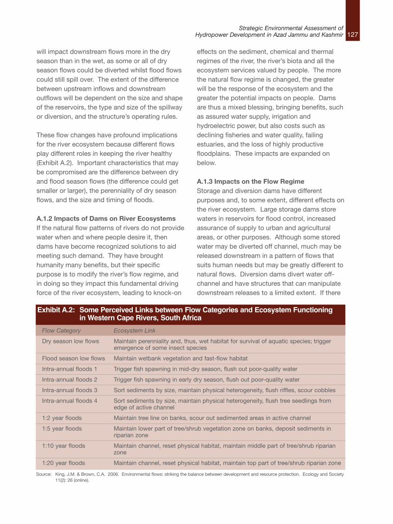
127Strategic Environmental Assessment of
Hydropower Development in Azad Jammu and Kashmir
will impact downstream flows more in the dryseason than in the wet, as some or all of dryseason flows could be diverted whilst flood flowscould still spill over. The extent of the differencebetween upstream inflows and downstreamoutflows will be dependent on the size and shapeof the reservoirs, the type and size of the spillwayor diversion, and the structure’s operating rules.
These flow changes have profound implicationsfor the river ecosystem because different flowsplay different roles in keeping the river healthy(Exhibit A.2). Important characteristics that maybe compromised are the difference between dryand flood season flows (the difference could getsmaller or larger), the perenniality of dry seasonflows, and the size and timing of floods.
A.1.2 Impacts of Dams on River EcosystemsIf the natural flow patterns of rivers do not providewater when and where people desire it, thendams have become recognized solutions to aidmeeting such demand. They have broughthumanity many benefits, but their specificpurpose is to modify the river’s flow regime, andin doing so they impact this fundamental drivingforce of the river ecosystem, leading to knock-on
effects on the sediment, chemical and thermalregimes of the river, the river’s biota and all theecosystem services valued by people. The morethe natural flow regime is changed, the greaterwill be the response of the ecosystem and thegreater the potential impacts on people. Damsare thus a mixed blessing, bringing benefits, suchas assured water supply, irrigation andhydroelectric power, but also costs such asdeclining fisheries and water quality, failingestuaries, and the loss of highly productivefloodplains. These impacts are expanded onbelow.
A.1.3 Impacts on the Flow RegimeStorage and diversion dams have differentpurposes and, to some extent, different effects onthe river ecosystem. Large storage dams storewaters in reservoirs for flood control, increasedassurance of supply to urban and agriculturalareas, or other purposes. Although some storedwater may be diverted off channel, much may bereleased downstream in a pattern of flows thatsuits human needs but may be greatly different tonatural flows. Diversion dams divert water off-channel and have structures that can manipulatedownstream releases to a limited extent. If there
Flow Category Ecosystem Link
Dry season low flows Maintain perenniality and, thus, wet habitat for survival of aquatic species; trigger emergence of some insect species
Flood season low flows Maintain wetbank vegetation and fast-flow habitat
Intra-annual floods 1 Trigger fish spawning in mid-dry season, flush out poor-quality water
Intra-annual floods 2 Trigger fish spawning in early dry season, flush out poor-quality water
Intra-annual floods 3 Sort sediments by size, maintain physical heterogeneity, flush riffles, scour cobbles
Intra-annual floods 4 Sort sediments by size, maintain physical heterogeneity, flush tree seedlings from edge of active channel
1:2 year floods Maintain tree line on banks, scour out sedimented areas in active channel
1:5 year floods Maintain lower part of tree/shrub vegetation zone on banks, deposit sediments in riparian zone
1:10 year floods Maintain channel, reset physical habitat, maintain middle part of tree/shrub riparian zone
1:20 year floods Maintain channel, reset physical habitat, maintain top part of tree/shrub riparian zone
Exhibit A.2: Some Perceived Links between Flow Categories and Ecosystem Functioning in Western Cape Rivers, South Africa
Source: King, J.M. & Brown, C.A. 2006. Environmental flows: striking the balance between development and resource protection. Ecology and Society 11(2): 26 (online).
is a constant offtake from a diversion dam, then itwill impact downstream flows more in the dryseason than in the wet, as some or all of dryseason flows could be diverted whilst flood flowscould still spill over. The extent of the differencebetween upstream inflows and downstreamoutflows will be dependent on the size and shapeof the reservoirs, the type and size of the spillwayor diversion, and the structure’s operating rules. These flow changes have profound implicationsfor the river ecosystem because different flowsplay different roles in keeping the river healthy(Exhibit A.2). Important characteristics that maybe compromised are the difference between dryand flood season flows (the difference could getsmaller or larger), the perenniality of dry seasonflows, and the size and timing of floods.
Impacts on the Sediment RegimeRiver systems comprise not just the water flowingin the river channel itself, but also the sedimentsuspended in the water column or depositedalong the river bed and banks. The erosion,transportation and deposition of these sedimentsby the river’s water during its passage to the seais responsible for shaping the features commonlyassociated with river channels, such asmeanders, sandbars, pools and deltas. Workingand re-working the sediments, the river createsand maintains complex, shifting mosaics offeatures that provide the diversity of habitatsupon which the river’s living organisms depend.Maintenance of these habitats is dependent on acontinuing supply from upstream of the rawmaterial—the silt, sand, gravel, cobbles andboulders supplied by the river bed and the widerlandscape. The same raw material maintainsbanks and shorelines and the bed in which thefoundations of bridges are sunk.
Dams form barriers to the transportation of muchof this raw material, with sediments dropping fromsuspension as the river slows down upon enteringthe reservoir. The finer sediments may stay insuspension and pass through the dam outletsduring floods and, sometimes, coarser material isscoured out through bottom gates to increase
storage in a sediment-choked reservoir. Damsthus can change the total amount of sedimentavailable to the river downstream, with aproportion of a river’s sediment load possiblypermanently trapped by the reservoir.
If sediments are trapped in this way, downstreamreaches are starved of them and may becomewhat is termed sediment hungry, eroding theirbed and banks at higher than natural rates.Channel adjustments may manifest as changes inchannel width, bed level and slope; down-cuttingand entrenchment of the channel; and bedarmouring or channel straightening. Land may belost through bank slumping and bridges androads threatened. The extent to which any ofthese is likely to occur will depend on how muchthe dam changes the river’s ability to transportsediment through flow changes, the amount ofsediment withheld by the reservoir and theerodibility of the bed and banks.
As the flow and sediment regimes of the river aretogether altered by dams, the downstreamphysical environment will change in a way thatreflects the interplay of these two forces.Sediments may decrease in the downstream riverbecause they are trapped in the reservoir, causingdownstream erosion, or they may increasebecause the remaining flow in the river isinsufficient to transport the sediments stilldraining in from the downstream catchment. Ifsediments are flushed from the reservoirperiodically, then periods of low sediment loadscould be interspersed with intermittent periods ofheavy, possibly, anoxic sediments movingdownstream—the two conditions togethercausing extreme conditions, neither of which isnatural.
In whatever way the channel adjustments playout, there will be impacts on the downstreamriverine habitats, perhaps through sedimentsclogging important spawning grounds, habitatsdegrading through erosion, floodplains decliningin extent and fertility, pools filling with sediments,or banks collapsing. All of these changes have
128Strategic Environmental Assessment ofHydropower Development in Azad Jammu and Kashmir
129Strategic Environmental Assessment of
Hydropower Development in Azad Jammu and Kashmir
implications for the riverine plants and animals, aswell as for cultivated land adjacent to the channel.
A.1.4 Impacts on the Chemical and ThermalRegimeWater stored in reservoirs undergoes physical,chemical and thermal changes, and sodownstream reaches may receive water that isquite different from that flowing into the reservoir.Typically, dams that release from near the surfaceof the reservoir, will deliver water that is warm andrich in oxygen, whereas dams releasing fromdeeper levels will deliver cold, nutrient-enriched,oxygen-poor water. The downstream water mayalso be clearer due to the reservoir trappingsediments and organic particles from upstream.These differences would generally be greater thelarger the reservoir, with those that retain water foronly a few hours or days inducing fairly lowchange.
A.1.5 Impacts on the Living RiverIn a naturally functioning river ecosystem, thediversity of habitats and the dynamic nature of theflow and other regimes enable a wide range ofspecies to coexist. Species have evolved oververy long time spans to live in harmony with thenatural conditions they experience. As water-resource developments change these habitatconditions, species may start to disappear andothers, more able to cope with the changedconditions, appear. Dominant species in the newcommunities may have been present in thenatural community but in low proportions, whilstthe changed conditions allow them to multiplyrapidly. Many species that can live in the newconditions may be more robust and hardy thanthe lost species, these being common attributesof species that negatively impact humans andtheir livestock. Examples of such robust pestspecies include mosquitoes that carry malaria andblackflies that can cause river blindness.
Most development-driven changes in riverecosystems manifest as slow declines incondition, but there are a few thresholds or statechanges. One is when floods are reduced to the
point that they no longer flood floodplains;another is when flow ceases and the riverbeddries out. In the former case, biodiversity andproductivity decline radically as floodplainsbecome drylands. In the latter case, aquaticspecies move away or die from the dried-outareas and, if this situation repeats at intervals, itwill favour hardy opportunistic species with shortlife cycles to the detriment of longer-living, usuallymore rare, species.
Rivers across the world are now seriouslydegraded in this way, with dams makingsignificant contributions to the degradation(Exhibit A.3). The impacts can be divided intothose that manifest upstream of the dam wall,downstream of the wall, or because of theexistence of the wall as a barrier.
Upstream Impacts of Dams and WeirsThe upstream reservoir changes the river reachthat it inundates from a flowing to a standingwater system. This can lead to thedisappearance in that stretch of river of speciesthat need flowing water (e.g., many species offish) and the appearance of those that can exist instill water (e.g., phytoplankton; zooplankton;mosquitoes).
Downstream Impacts of Dams and WeirsThe downstream impacts of dams are usually feltover much longer distances than are upstreamimpacts. The timing and duration of different flowevents may be changed downstream, and waterdepths and velocities may change outside of therange that species have evolved to cope with. Inthe case of the Kishenganga Dam, the maindownstream impact is expected to be thereduction of flows in the dry season as most flowis diverted away from the river. There may beadditional impacts through storage of sedimentsin the reservoir and periodic flushing of some ofthis load downstream.
Dams and Weirs as BarriersMost large freshwater fish and some invertebratesrely on movement through river systems to
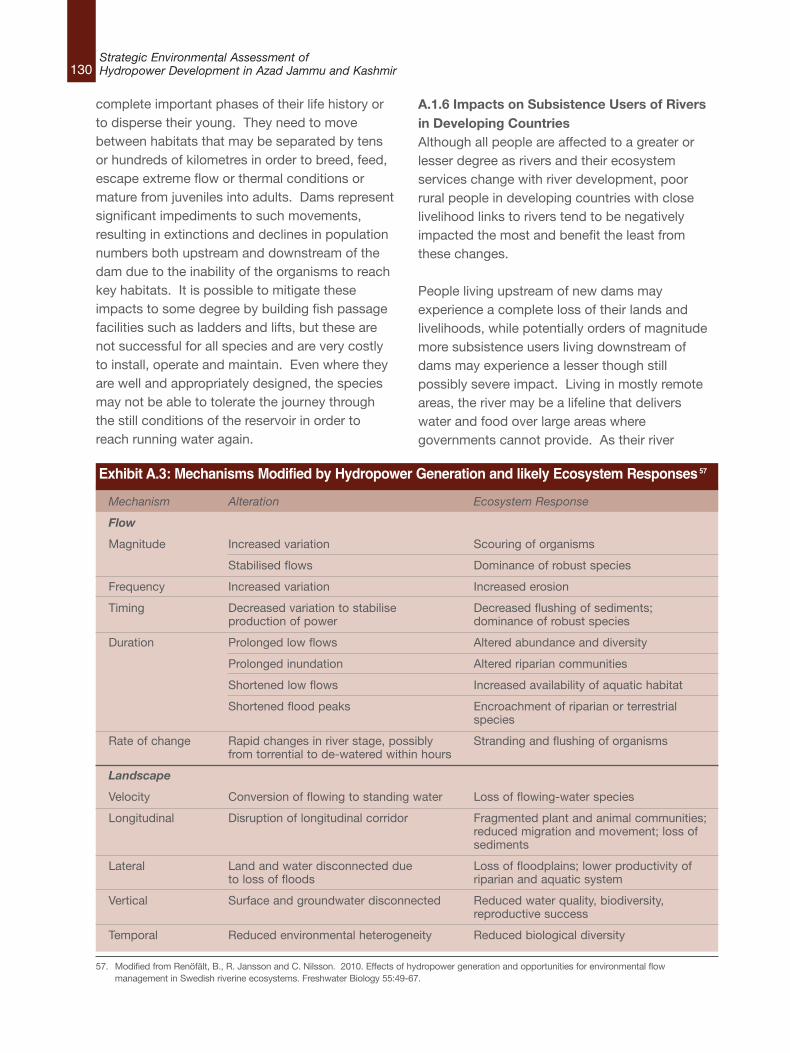
130Strategic Environmental Assessment ofHydropower Development in Azad Jammu and Kashmir
Mechanism Alteration Ecosystem Response
Flow
Magnitude Increased variation Scouring of organisms
Stabilised flows Dominance of robust species
Frequency Increased variation Increased erosion
Timing Decreased variation to stabilise Decreased flushing of sediments; production of power dominance of robust species
Duration Prolonged low flows Altered abundance and diversity
Prolonged inundation Altered riparian communities
Shortened low flows Increased availability of aquatic habitat
Shortened flood peaks Encroachment of riparian or terrestrial species
Rate of change Rapid changes in river stage, possibly Stranding and flushing of organismsfrom torrential to de-watered within hours
Landscape
Velocity Conversion of flowing to standing water Loss of flowing-water species
Longitudinal Disruption of longitudinal corridor Fragmented plant and animal communities; reduced migration and movement; loss of sediments
Lateral Land and water disconnected due Loss of floodplains; lower productivity of to loss of floods riparian and aquatic system
Vertical Surface and groundwater disconnected Reduced water quality, biodiversity, reproductive success
Temporal Reduced environmental heterogeneity Reduced biological diversity
Exhibit A.3: Mechanisms Modified by Hydropower Generation and likely Ecosystem Responses57
complete important phases of their life history orto disperse their young. They need to movebetween habitats that may be separated by tensor hundreds of kilometres in order to breed, feed,escape extreme flow or thermal conditions ormature from juveniles into adults. Dams representsignificant impediments to such movements,resulting in extinctions and declines in populationnumbers both upstream and downstream of thedam due to the inability of the organisms to reachkey habitats. It is possible to mitigate theseimpacts to some degree by building fish passagefacilities such as ladders and lifts, but these arenot successful for all species and are very costlyto install, operate and maintain. Even where theyare well and appropriately designed, the speciesmay not be able to tolerate the journey throughthe still conditions of the reservoir in order toreach running water again.
A.1.6 Impacts on Subsistence Users of Riversin Developing CountriesAlthough all people are affected to a greater orlesser degree as rivers and their ecosystemservices change with river development, poorrural people in developing countries with closelivelihood links to rivers tend to be negativelyimpacted the most and benefit the least fromthese changes.
People living upstream of new dams mayexperience a complete loss of their lands andlivelihoods, while potentially orders of magnitudemore subsistence users living downstream ofdams may experience a lesser though stillpossibly severe impact. Living in mostly remoteareas, the river may be a lifeline that deliverswater and food over large areas wheregovernments cannot provide. As their river
57. Modified from Renöfält, B., R. Jansson and C. Nilsson. 2010. Effects of hydropower generation and opportunities for environmental flowmanagement in Swedish riverine ecosystems. Freshwater Biology 55:49-67.
resources degrade with upstream developmentsand the benefits are enjoyed by people elsewhere,the rural poor have few prospects ofcompensation. River resources, such as fish, maydecline, for instance, with lower catches andsmaller sizes. Declining cultural and recreationalopportunities may force more and morehouseholds to abandon livelihoods linked to theriver.
A second major impact of dams can be increasedhealth risks. Both people and livestock can beaffected, with significant increases in malaria andbilharzia for people and liver fluke for cattle, forinstance, being linked to specific new dams.
A.1.7 Environmental Benefits of DamsThe World Commission on Dams found thatthough there may be an array of social benefits todams there are few environmental benefits.58
Although it may be possible to mitigate some oftheir negative impacts through providingenvironmental flows, sediment sluicing or fishpassage facilities, it is not possible to mitigate allfactors. In many cases, the worst environmentalimpacts are difficult to predict and remediate. Itmay be argued that while dams are detrimental tosome species, they provide opportunities forothers—such as new fisheries in reservoirs. Evenin this case, however, the effect often is topromote an exotic species at the expense ofindigenous species. The benefits that accruefrom dams extend almost exclusively to socialand economic spheres rather than to ecologicalones.
131Strategic Environmental Assessment of
Hydropower Development in Azad Jammu and Kashmir
58. World Commission on Dams (2000) Dams and Development a New Framework for Decision-making. The Report of the Word Commission on Dams.London: Earthscan Publications, Thanet Press.
132Strategic Environmental Assessment ofHydropower Development in Azad Jammu and Kashmir
B.1 River CharacteristicsAJK is drained by three main rivers viz., Neelum,Jhelum and Poonch, all draining into ManglaReservoir. The Mangla Dam is the twelfth largestdam in the world. It was constructed in 1967across the Jhelum River in Mirpur District of AzadKashmir. A map of AJK along with its rivers isshown in Exhibit B.1.
The rivers draining into the Mangla reservoir havedifferent characteristics as they originate fromareas having different geographical and physicalfeatures. The Poonch River originates in thewestern foothills of Pir Panjal Range. The steepslopes of the Pir Panjal form the upper catchmentof this river. It is a small gurgling water channel inthis tract and descends along a very steepgradient until it reaches the foothills. The riverwidens as more and more tributaries from bothsides enter the main stream. The valley too opensup and Poonch River begins to flow in a leisurelymanner in its middle and lower reaches. Theupper catchment is covered by dense forestswhile the vegetation of the middle and lowerregion is under intense biotic pressure. PoonchRiver from the Line of Control (LoC) to Kotli townhas a steep slope (6.9-8.3 m/km) and the valley isnarrow. Below Kotli the river gradient is relativelymild (3.7m/km). The river ultimately joins theMangla lake.
River Jhelum originates from a spring at Verinagsituated at the foot of the Pir Panjal in thesoutheastern part of the valley of Kashmir. It flowsthrough Srinagar and the Wular Lake beforeentering Pakistan from Indian Occupied Kashmir(IOK) through a deep narrow gorge. The NeelumRiver, the largest tributary of the Jhelum — knownas Kishenganga River in India and IOK — joins itnear Muzaffarabad. River Jhelum in its upperreaches from the LoC to its confluence with theNeelum River has a very steep slope (7.4m/km),while in the lower reaches from Neelum
confluence to Mangla Reservoir the gradient ismilder (2.7m/km) but the valley is very narrow andthe river flows through a gorge.
River Neelum originates from the glaciers ofnorthern Kashmir and flows through the GurezValley in its upper reaches and through NeelumValley in its lower reaches until it joins with RiverJhelum at Muzaffarabad. It flows for 250 km inAJK from the LoC at Taobat to Muzaffarabad.River Neelum receives various streams in AJK, thefamous being the Dudhgai Nullah, ShountarNullah, Dudhnial Nullah and Nauseri Nullah.
Neelum is a cold-water river with temperaturesless than 15 °C, generally around 12 °C, evenduring the summer months. The Poonch is thewarm water river and the water temperature of therivers approaches 30 °C during the summermonths. Water in the Jhelum River has anintermediate temperature and the watertemperatures reach 25 °C during the summermonths. Another temperature regime is developeddownstream Muzaffarabad after the confluence ofNeelum and Jhelum rivers. The temperature of theriver water remains around 16-17 °C. Thesevariable temperature regimes provide uniquephysico-chemical characteristics and hence avariation in fish compositions in the differentreaches of the rivers and reservoirs.
B.2 Overview of Aquatic Flora and FaunaThis section presents an overview of the fishfauna, benthic macro-invertebrates and algal florafound in the rivers of AJK. A literature review ofresearch articles, previous EIA (EnvironmentalImpact Assessment) reports, relevant books andwebsites was carried out to gather thisinformation.
B.2.1 FishThe upper reaches of the Neelum River arecharacterized by fast flows, high oxygen
Appendix B: Environmental Baseline: Background Information
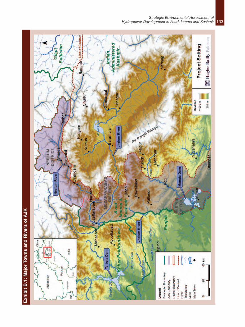
133Strategic Environmental Assessment of
Hydropower Development in Azad Jammu and KashmirExh
ibit B.1: Major To
wns an
d Rivers of A
JK
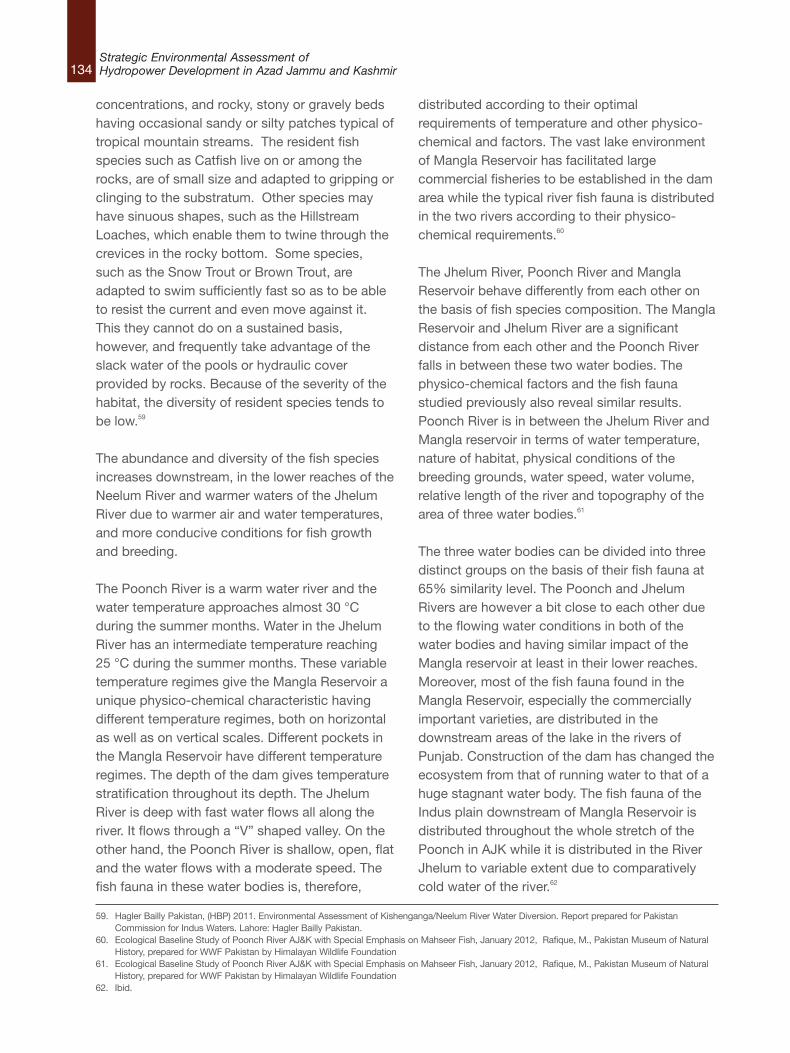
134Strategic Environmental Assessment ofHydropower Development in Azad Jammu and Kashmir
concentrations, and rocky, stony or gravely bedshaving occasional sandy or silty patches typical oftropical mountain streams. The resident fishspecies such as Catfish live on or among therocks, are of small size and adapted to gripping orclinging to the substratum. Other species mayhave sinuous shapes, such as the HillstreamLoaches, which enable them to twine through thecrevices in the rocky bottom. Some species,such as the Snow Trout or Brown Trout, areadapted to swim sufficiently fast so as to be ableto resist the current and even move against it.This they cannot do on a sustained basis,however, and frequently take advantage of theslack water of the pools or hydraulic coverprovided by rocks. Because of the severity of thehabitat, the diversity of resident species tends tobe low.59
The abundance and diversity of the fish speciesincreases downstream, in the lower reaches of theNeelum River and warmer waters of the JhelumRiver due to warmer air and water temperatures,and more conducive conditions for fish growthand breeding.
The Poonch River is a warm water river and thewater temperature approaches almost 30 °Cduring the summer months. Water in the JhelumRiver has an intermediate temperature reaching25 °C during the summer months. These variabletemperature regimes give the Mangla Reservoir aunique physico-chemical characteristic havingdifferent temperature regimes, both on horizontalas well as on vertical scales. Different pockets inthe Mangla Reservoir have different temperatureregimes. The depth of the dam gives temperaturestratification throughout its depth. The JhelumRiver is deep with fast water flows all along theriver. It flows through a “V” shaped valley. On theother hand, the Poonch River is shallow, open, flatand the water flows with a moderate speed. Thefish fauna in these water bodies is, therefore,
distributed according to their optimalrequirements of temperature and other physico-chemical and factors. The vast lake environmentof Mangla Reservoir has facilitated largecommercial fisheries to be established in the damarea while the typical river fish fauna is distributedin the two rivers according to their physico-chemical requirements.60
The Jhelum River, Poonch River and ManglaReservoir behave differently from each other onthe basis of fish species composition. The ManglaReservoir and Jhelum River are a significantdistance from each other and the Poonch Riverfalls in between these two water bodies. Thephysico-chemical factors and the fish faunastudied previously also reveal similar results.Poonch River is in between the Jhelum River andMangla reservoir in terms of water temperature,nature of habitat, physical conditions of thebreeding grounds, water speed, water volume,relative length of the river and topography of thearea of three water bodies.61
The three water bodies can be divided into threedistinct groups on the basis of their fish fauna at65% similarity level. The Poonch and JhelumRivers are however a bit close to each other dueto the flowing water conditions in both of thewater bodies and having similar impact of theMangla reservoir at least in their lower reaches.Moreover, most of the fish fauna found in theMangla Reservoir, especially the commerciallyimportant varieties, are distributed in thedownstream areas of the lake in the rivers ofPunjab. Construction of the dam has changed theecosystem from that of running water to that of ahuge stagnant water body. The fish fauna of theIndus plain downstream of Mangla Reservoir isdistributed throughout the whole stretch of thePoonch in AJK while it is distributed in the RiverJhelum to variable extent due to comparativelycold water of the river.62
59. Hagler Bailly Pakistan, (HBP) 2011. Environmental Assessment of Kishenganga/Neelum River Water Diversion. Report prepared for PakistanCommission for Indus Waters. Lahore: Hagler Bailly Pakistan.
60. Ecological Baseline Study of Poonch River AJ&K with Special Emphasis on Mahseer Fish, January 2012, Rafique, M., Pakistan Museum of NaturalHistory, prepared for WWF Pakistan by Himalayan Wildlife Foundation
61. Ecological Baseline Study of Poonch River AJ&K with Special Emphasis on Mahseer Fish, January 2012, Rafique, M., Pakistan Museum of NaturalHistory, prepared for WWF Pakistan by Himalayan Wildlife Foundation
62. Ibid.
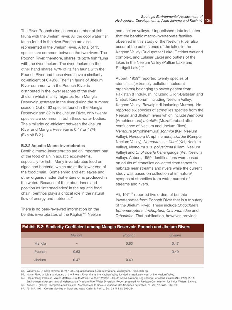
135Strategic Environmental Assessment of
Hydropower Development in Azad Jammu and Kashmir
The River Poonch also shares a number of fishfauna with the Jhelum River. All the cool water fishfauna found in the river Poonch are alsorepresented in the Jhelum River. A total of 15species are common between the two rivers. ThePoonch River, therefore, shares its 52% fish faunawith the river Jhelum. The river Jhelum on theother hand shares 47% of its fish fauna with thePoonch River and these rivers have a similarityco-efficient of 0.49%. The fish fauna of JhelumRiver common with the Poonch River isdistributed in the lower reaches of the riverJhelum which mainly migrates from ManglaReservoir upstream in the river during the summerseason. Out of 62 species found in the ManglaReservoir and 32 in the Jhelum River, only twentyspecies are common in both these water bodies.The similarity co-efficient between the JhelumRiver and Mangla Reservoir is 0.47 or 47%(Exhibit B.2.).
B.2.2 Aquatic Macro-invertebratesBenthic macro-invertebrates are an important partof the food chain in aquatic ecosystems,especially for fish. Many invertebrates feed onalgae and bacteria, which are at the lower end ofthe food chain. Some shred and eat leaves andother organic matter that enters or is produced inthe water. Because of their abundance andposition as ‘intermediaries’ in the aquatic foodchain, benthos plays a critical role in the naturalflow of energy and nutrients.63
There is no peer-reviewed information on thebenthic invertebrates of the Kaghan64, Neelum
and Jhelum valleys. Unpublished data indicatesthat the benthic macro-invertebrate familiesobserved in this study of the Neelum River alsooccur at the outlet zones of the lakes in theKaghan Valley (Dudupatsar Lake, Gittidas wetlandcomplex, and Lulusar Lake) and outlets of thelakes in the Neelum Valley (Patlian Lake andRattigali Lake).65
Aubert, 195966 reported twenty species ofstoneflies (extremely pollution intolerantorganisms) belonging to seven genera fromPakistan (Hindukush including Gilgit-Baltistan andChitral; Karakorum including Neelum Valley,Kaghan Valley; Rawalpindi including Murree). Hereported six species of stoneflies species from theNeelum and Jhelum rivers which include Nemoura(Amphinemura) mirabilis (Muzaffarabad afterconfluence of Neelum and Jhelum River),Nemoura (Amphinemura) schmidi (Kel, NeelumValley), Nemoura (Amphinemura) skardui (RampurNeelum Valley), Nemoura s. s. lilami (Kel, NeelumValley), Nemoura s. s. polystigma (Lilam, NeelumValley) and Cholroperla kishanganga (Kel, NeelumValley). Aubert, 1959 identifications were basedon adults of stoneflies collected from terrestrialhabitats near streams and rivers while the currentstudy was based on collection of immature/nymphs of stoneflies from water current ofstreams and rivers.
Ali, 197167 reported five orders of benthicinvertebrates from Poonch River that is a tributaryof the Jhelum River. These include Oligochaeta,Ephemeroptera, Trichoptera, Chironomidae andTabanidae. That publication, however, provides
63. Williams D. D. and Feltmate, B. W. 1992. Aquatic Insects. CAB International Wallingford, Oxon. 360 pp.64. Kunar River, which is a tributary of the Jhelum River, drains the Kaghan Valley located immediately west of the Neelum Valley.65. Hagler Bailly Pakistan, Water Matters – South Africa, Southern Waters – South Africa, National Engineering Services Pakistan (NESPAK), 2011,
Environmental Assessment of Kishenganga /Neelum River Water Diversion. Report prepared for Pakistan Commission for Indus Waters, Lahore.66. Aubert, J. (1959): Plécoptères du Pakistan. Memoires de la Societe vaudoise des Sciences naturelles, 75, Vol. 12, fasc. 3:65-91.67. Ali, S.R. 1971. Certain Mayflies of Swat and Azad Kashmir. Pak. J. Sci. 23 (5 & 6): 209-214.
Mangla Poonch Jhelum
Mangla – 0.63 0.47
Poonch 0.63 – 0.49
Jhelum 0.47 0.49 –
Exhibit B.2: Similarity Coefficient among Mangla Reservoir, Poonch and Jhelum Rivers
Strategic Environmental Assessment ofHydropower Development in Azad Jammu and Kashmir136
very limited information about the composition ofthe benthic macro-invertebrate assemblages asidentification was limited to order level.
Sehgal et al., 199168 reported six taxa (order levelidentification) of benthic macro-invertebrates fromstreams of the Jhelum River (Indian territory)along with their per square meter abundance atspecified locations.
Bhatt et al., 2005 reported twelve taxa (order levelidentification) from Neelum river (Indian territory)along with their per square meter abundance atspecified locations
During the field work conducted by Hagler BaillyPakistan in 2008, a total of 33 macro-invertebratetaxa were identified in the upper Neelum River.69
A total of 70 invertebrate taxa were identified fromthe Neelum and Jhelum rivers during the samplingsurveys conducted by HBP in 2011 and 2012.70
B.2.3 Algal FloraThere are three kingdoms of algae recorded fromthe rivers of Azad Kashmir - the kingdom Moneraconsists of free-floating phytoplanktons, thekingdom Protoctista consists of attached algae,while the kingdom Protista consists of free-floating as well as attached algae. Macrophytesare largely absent in the Neelum Valley and theattached algae are mainly confined to the rockyand cobblestone substrata. Studies on algaeconducted in the adjacent Kaghan Valley west ofthe Neelum Valley indicate similar patterns ofdiversity. Temperature is one of the principalregulators of algal abundance, and in temperaterivers like the Neelum there is a minimum algalproduction during the winter and comparativelyhigher production during the summer season.71
The abundance of algal flora is likely to be higherin the warmer waters of the Jhelum River andPoonch River.
B.3 Overview of Terrestrial EcologyThis section gives a brief overview of theterrestrial ecology of AJK, particularly thoseecological resources that are found in the vicinityof the rivers or depend on the river for food, wateror habitat.
B.3.1 Terrestrial FloraThere are four phyto-geographical regions inPakistan including AJK which are Saharo-Sindian,Irano-Turanian, Sino-Japanese and Indian.72
Floristically the AJK falls into Sino-Japanesegroup and is very rich in floral diversity. Itcomprises evergreen coniferous forest,subtropical thorny forest, and deciduous treesforest. With its good climate, the area has about10.6% of the total flora of Pakistan.73 Most of theAJK forest falls in the major forest type ‘MontaneTemperate Forests’.74
The Neelum and Jhelum valleys are surroundedby high mountains with steep or gentle slopes,valleys, and small pitches plains (pasture area)and agricultural fields. The area’s vegetation covervaries with various habitats. The slopes aregenerally good with vegetation cover except forthe steepest stony cliffs, where the vegetation invery thin. The extent of degradation also variesfrom place to place. The degradation ofvegetation observed is significant along the riverbanks as compared to the higher elevation. Thebank of rivers and floodplains are usually easilyaccessible and grazing pressure and extraction ofwood for timber and fuel are visible. Grazingpressures on the slopes near the settlements isalso significant, as well as in the pastures whereboth nomadic herdsmen and the local communitytake the livestock for grazing during summermonths.
68. Sehgal, K. L., 1991. Distributional patterns, structural modifications and diversity of Benthic biota in Mountain streams of North Western Himalaya. In: D.Bhatt and P.K. Pandey (Eds.), Ecology of the Mountain Water, pp. 199-247. Ashish Publishing House, New Delhi.
69. Hagler Bailly Pakistan, Water Matters – South Africa, Southern Waters – South Africa, National Engineering Services Pakistan (NESPAK), 2011,Environmental Assessment of Kishenganga /Neelum River Water Diversion. Report prepared for Pakistan Commission for Indus Waters, Lahore.
70. Ibid.71. Hagler Bailly Pakistan, Water Matters – South Africa, Southern Waters – South Africa, National Engineering Services Pakistan (NESPAK), 2013.
Environmental Assessment of Neelum Jhelum Hydroelectric Project River Diversion. Interim Report prepared for Ministry of Water and Power, Islamabad.72. Rafiq, Rubina A., and Nasir, Yasin J. 1995. Wild Flowers of Pakistan, Oxford University Press.73. Ali S.I. and M. Qaiser. 1986. A Phytogeographical Analysis of Phanerogams of Pakistan. Proceedings of the Royal Botanical Society, 89B: 89-10174. Champion, Seth and Khattak 1965. Forest ecology; Forests and forestry; Pakistan
137Strategic Environmental Assessment of
Hydropower Development in Azad Jammu and Kashmir
Floristically, there are three main ecozones in thevicinity of the AJK rivers; namely temperatemountain forest, mountain sub-tropical forest anda mix of sub-tropical thorn forest deciduousforest. The dominant species of each ecozone aredescribed below.
Temperate Mountain ZoneHimalayan moist temperate forests andHimalayan dry temperate forests are found in thiszone. These forests are located between 1,500 mand 3,000 m, the former in areas where the annualprecipitation is more than 1,000 mm and the latterin areas with less precipitation.
Evergreen Himalayan moist temperate forests arecharacterized by conifers, with a mixture of oakand deciduous broad-leaved trees. Theirundergrowth is rarely dense, and consists of bothevergreen and deciduous species. These forestsare divided into a lower and an upper zone, ineach of which definite species of conifers or oaksdominate. The common species are Cedrusdeodara (Deodar, diar), Pinus wallichiana, Piceasmithiana, Abies pindrow (partal). In theHimalayan dry temperate forests, both coniferousand broad-leaved species are present. The mainconifers are Cedrus deodara, Pinus gerardianaand Juniperus macropoda. Pinus wallichiana andPecea smithiana are also present. Broad-leavedtrees include Quercus ilex, Fraxinus sp. and Acersp. Shrubs in the undercover include Daphne,Lonicera, Prunus, Artemisia, Astragalus andEphedra sp. Livestock grazing practice isobserved in this area.
Mountain Sub-Tropical ZoneThe forest type found in this zone is the sub-tropical pine forest and forests relatively narrowzone lays with thin floral diversity. These are openflammable pine forests sometimes with, but oftenwithout, a dry evergreen shrub layer and little orno undergrowth. The forests consist of Pinusroxburghii (chir pine) found between 900 m and1,700 m elevation in the western Himalayas within
the range of the south-west summer monsoon. Itis the only pine of these forests though there is asmall overlap with Pinus wallichiana (biar) at theupper limit. Other dominant plant species of thiszone are Quercus incana with under story ofshrubs such as Berberis lyceum, Berberisheteropoda, Carissa oppaca, Cotoneaster spp.and grasses such as Themeda anathera andApluda aristata. The habitat in this zone isrelatively degraded at some localities by thefurrow agricultural practices and encroachmentby the settlements.
Admix of Sub-Tropical Thorn Forest DeciduousZoneIn the ecozone between 550–900 m thevegetation is mixed sub-tropical thorny anddeciduous vegetation. This habitat can becharacterized by lush green vegetation withnarrow altitudinal strip. This zone is dominated byplant community of Acacia modesta, Oliaferruginea, Cassia fistula, Carissa oppaca,Dodonaea viscosa, on hotter slopes whileMallotus philippensis, Adhatoda vescosa,Zizyphus nummularia and Dodonaea viscosa onthe cooler slopes. The zone has significantproportion of the area covered by agriculture andurbanization. However, the vegetation cover inthis zone in some of the areas is largely intact withbetter floral diversity. The areas covered by thishabitat are the low foothills in the vicinity of therivers.
B.3.2 Forest AreasThere is 1,400,415 acres of forest land in AJK andit is distributed in different forest types due tovariation in climatic factors. As a result of thedifferences in climatic conditions there is a widevariety of life, both in fauna and flora.75
Forests of AJK are managed by the guidelinesprovided in the Jammu and Kashmir ForestRegulations of 1930. These guidelines provide thebasis for the regulation, protection, conservation,and management of forest in the area. The AJK
75. Official website of the AJK government available at: http://www.ajk.gov.pk/
138Strategic Environmental Assessment ofHydropower Development in Azad Jammu and Kashmir
forest are divided into ten administrative unitsnamely the Forest Divisions. These includeSharda, Keran, Muzaffarabad, Jhelum Valley,Bagh, Havelly, Poonch, Kotli, Mirpur and Bhimber.Each forest division is structured for scientificmanagement of forest resources on sustainablebasis to achieve specific silvicultural, social andeconomic objectives. These ten forest divisionhave been grouped into five management units onthe basis of similarity in forest composition,geographic and socio-economic conditions.76
The forests of AJK are categorized into thedemarcated forest and un-demarcated forestcategories. Demarcated forest means forest landor waste land under the control of ForestDepartment, of which boundaries have alreadybeen demarcated by means of pillars of stones ormasonry or by any other conspicuous mark, orwhich may hereafter be constituted a demarcatedforest under section 3 of Regulation. Un-demarcated forest means and includes all forestland and waste land (other than demarcatedforest) under the management and control of theRevenue Department) which is the property of theGovernment and is not appropriated for anyspecific purpose.
The Forests of Azad Kashmir are composed ofvarious forest types that range from subtropical toalpine zones. The main forest types include,scrubs, subtropical Chir pine forests, mixedconifer temperate forests and alpine/sub-alpineforests and pastures. These forest types reflectdifferent vegetation types, composition, densitiesand silvicultural requirements.
Apart from timber, coniferous forests in AJKprovide many species of medicinal plants andnuts which are used by local people as well aspharmaceutical industry. About 50 tons of variousplant species are collected annually. The mostimportant among them are; Saussurea lapa,Dioscorea deltoidea, Ploygonum emplexicaule,Rheum emodi and Valeriana wallichii.Approximately 10 tons of white and blackmushrooms are collected annually.
A large number of nomads with their multitude offlocks visit and utilize upland forests of AzadKashmir for their livelihood as well as for theiranimals during the season. These people live aprimitive life style and put an enormous pressureon forest resources.
Due to anthropogenic pressures, some plantshave undergone a significant decline in numbers.such as Yew (Taxus baccata) Ash (Fraxinus spp.)and Fir (Abies pindrow) among trees and Costusroots (Saussurea lapa) among herbs. The annualextraction of Costus roots has been disallowed bythe AJK Forest Department due to theinternational ban on the trade of product.
B.3.3 Riparian Vegetation A riparian zone or riparian area is the interfacebetween land and a river or stream. Planthabitats and communities along the river marginsand banks are called riparian vegetation. Theriparian vegetation flora linked to the AJK can becategorized as marginal (river slope) vegetationand floodplain vegetation. The marginal zone ofthe river is that part of the river channel, close tothe river bank, that is frequently submerged bythe active channel width of the river duringperiods of high flows and left dry during periodsof low flows when the active channel widthreduces. Unlike flood plains, which aresubmerged by water during floods only, themarginal zone may be inundated or left drydepending on the varying width of the activechannel during high or low tides in the same dayor during periods of high rainfall. Water-lovingmarginal vegetation is situated along the bothsides of river, while vegetation in the floodplains isinundated periodically by floods and benefits fromthe soil deposited by the river.
Some of the dominant plant species of marginalvegetation in the Neelum and Jhelum valleysinclude Salix sp., Populus sp., Salix sp., Aesculusindica, Sambucus wightiana, Ribes himalense,and Corydalis falconer. These plants are mostlytrees and shrubs, and have strong and spreading
76. Ibid.
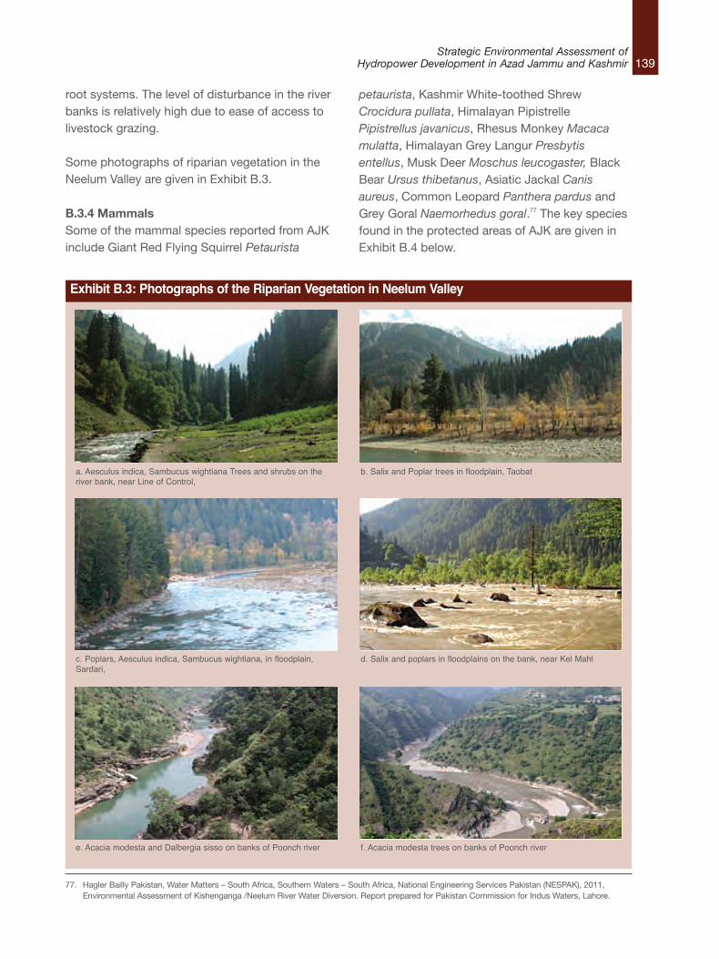
139Strategic Environmental Assessment of
Hydropower Development in Azad Jammu and Kashmir
root systems. The level of disturbance in the riverbanks is relatively high due to ease of access tolivestock grazing.
Some photographs of riparian vegetation in theNeelum Valley are given in Exhibit B.3.
B.3.4 MammalsSome of the mammal species reported from AJKinclude Giant Red Flying Squirrel Petaurista
petaurista, Kashmir White-toothed ShrewCrocidura pullata, Himalayan PipistrellePipistrellus javanicus, Rhesus Monkey Macacamulatta, Himalayan Grey Langur Presbytisentellus, Musk Deer Moschus leucogaster, BlackBear Ursus thibetanus, Asiatic Jackal Canisaureus, Common Leopard Panthera pardus andGrey Goral Naemorhedus goral.77 The key speciesfound in the protected areas of AJK are given inExhibit B.4 below.
Exhibit B.3: Photographs of the Riparian Vegetation in Neelum Valley
a. Aesculus indica, Sambucus wightiana Trees and shrubs on theriver bank, near Line of Control,
b. Salix and Poplar trees in floodplain, Taobat
c. Poplars, Aesculus indica, Sambucus wightiana, in floodplain,Sardari,
d. Salix and poplars in floodplains on the bank, near Kel Mahl
e. Acacia modesta and Dalbergia sisso on banks of Poonch river f. Acacia modesta trees on banks of Poonch river
77. Hagler Bailly Pakistan, Water Matters – South Africa, Southern Waters – South Africa, National Engineering Services Pakistan (NESPAK), 2011,Environmental Assessment of Kishenganga /Neelum River Water Diversion. Report prepared for Pakistan Commission for Indus Waters, Lahore.
140Strategic Environmental Assessment ofHydropower Development in Azad Jammu and Kashmir
The only mammal found in AJK that is directlydependent on the river for its survival is the Otter.There are two species of Otter found in KashmirValley. These include Common Otter (also knownas Eurasian Otter (Lutra lutra) and Smooth-coatedOtter (Lutrogale perspicillata). The Common Otter(Lutra lutra) was formerly found in the riversystems of the entire Himalayan region, extendingin summer to small mountain torrents as high as3,500 m.78 Like other otter species in Asia, itspopulation is on the decline.79 Wide hunting for furof the Common Otter, which has commercialvalue, has been cited as the main reason for thepopulation decline. Today, it is rare to find Otter inthe Neelum Valley, although it has been reportedfrom other parts of the Jammu and Kashmir.80
Common Otter or Eurasian Otter (Lutra lutra) isNear Threatened in IUCN Red List 2013.81 Officialsof Azad Kashmir Wildlife Department havereported observing footprints of Otter in theUpper Neelum Valley in autumn 2008.82 Since thespecies is mainly nocturnal, there are difficulties inits observation. However, available informationsuggests its presence in the upper parts ofKashmir Valley. Smooth-coated Otter (Lutrogaleperspicillata) is thought to be present in the lowerparts of the Kashmir, but exact number anddistribution of Smooth-coated Otter (Lutrogaleperspicillata) in the valley is not known. Smooth-coated Otter (Lutrogale perspicillata) is Vulnerablein IUCN Red List 2013. Further studies arerequired to study Otter distribution, behavior, anddependence on the river for food. The Otter isheavily dependent on the river for its survival.During the day, the otters hide in burrows in thebanks of the rivers. As the burrows usually havetheir entrances below the water level, they aredifficult to find and therefore also protect the
animals from their natural and human predators.Reduction in river water will, in addition topotentially affecting their source of food, havesignificant impact on their survivals by exposingtheir burrows.83
B.3.5 ReptilesVery little information is available about thereptiles and amphibians found in the vicinity of therivers in AJK. Four reptile and one amphibianspecie have been reported from the Neelum andJhelum river banks.84 These include Kashmir RockAgama Agama tuberculata, Himalayan RockAgama Agama himalayana, Himalayan Pit ViperAgkistodron himalayanus, and Cliff Racer Coluberrhodorachis. The amphibian species reported isIndus Toad Bufo andersoni.
B.3.6 BirdsA total of 442 bird species have been reportedfrom AJK.85 These include members of the familyPhasianidae, Anatidae, Podicipedidae, Ardeidae,Falconidae, Accipitridae, Cuculidae, Strigidae,Corvidae etc. Most of the bird species areresident. However, some migratory bird specieshave also been reported from AJK.
A wide variety of water birds have been reportedfrom different water bodies of AJK. These includeresident and migratory birds. More than 45species of water birds have been documented inthe valley. Abundant local water birds include theLittle Cormorant Phalacrocorax niger, Great EgretEgretta garzetta, Intermediate Egret Mesophoyxintermedia, Black-winged Stilt Himantopushimantopus, Little Grebe Tachybaptus ruficollisand Indian River Tern Sterna aurantia.86 Themigratory birds mostly consist of members of the
78. Roberts, T.J. 1997. The Mammals of Pakistan. Oxford University Press Karachi. 525 pp 79. Conroy, J., Melisch, R. and Chanin, P., 1998. The distribution and status of Eurasian otter (Lutra lutra) in Asia – A preliminary review. IUCN OSG Bull. 15:
15-3080. HUSSAIN, S.A., 1998. Conservation status of otters in the Tarai and Lower Himalayas of Uttar Pradesh, India. Proceedings 7th International Otter
Colloquium, Trebon, Czeck Republic. pp. 131-14281. IUCN 2011. IUCN Red List of Threatened Species. Version 2013.1. <www.iucnredlist.org>. Downloaded on 16 September 201382. Private communication between HBP ecology team members and officials from the Wildlife Department.83. Hagler Bailly Pakistan, Water Matters – South Africa, Southern Waters – South Africa, National Engineering Services Pakistan (NESPAK), 2011,
Environmental Assessment of Kishenganga /Neelum River Water Diversion. Report prepared for Pakistan Commission for Indus Waters, Lahore.84. Baseline Study of Protected Area in North Kashmir, Himalayan Wildlife Foundation 200685. Bird Life International website. Accessed on 4 September. http://avibase.bsc-eoc.org/checklist.jsp?region=PKjk&list=howardmoore86. Azam, M.M.and Rasool, G. 2010-2012. Mid-winter Waterfowl Census Report of Mangla Reservoir, Tanda Dam and Poonch River. Unpublished report of
WWF-P and ZSD.
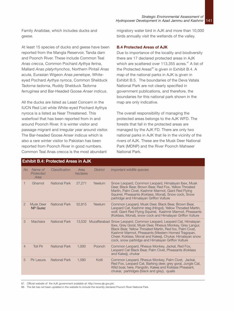
141Strategic Environmental Assessment of
Hydropower Development in Azad Jammu and Kashmir
Family Anatidae, which includes ducks andgeese.
At least 15 species of ducks and geese have beenreported from the Mangla Reservoir, Tanda damand Poonch River. These include Common TealAnas crecca, Common Pochard Aythya ferina,Mallard Anas platyrhynchos, Northern Pintail Anasacuta, Eurasian Wigeon Anas penelope, White-eyed Pochard Aythya nyroca, Common ShelduckTadorna tadorna, Ruddy Shelduck Tadornaferruginea and Bar-Headed Goose Anser indicus.
All the ducks are listed as Least Concern in theIUCN Red List while White-eyed Pochard Aythyanyroca is a listed as Near Threatened. Thiswaterfowl that has been reported from in andaround Poonch River. It is winter visitor andpassage migrant and irregular year around visitor.The Bar-headed Goose Anser indicus which isalso a rare winter visitor to Pakistan has beenreported from Poonch River in good numbers.Common Teal Anas crecca is the most abundant
migratory water bird in AJK and more than 10,000birds annually visit the wetlands of the valley.
B.4 Protected Areas of AJK Due to importance of the locality and biodiversitythere are 17 declared protected areas in AJKwhich are scattered over 113,355 acres.87 A list ofthe Protected Areas88 is given in Exhibit B.4. Amap of the national parks in AJK is given inExhibit B.5. The boundaries of the Deva VatalaNational Park are not clearly specified ingovernment publications, and therefore, theboundaries for this national park shown in themap are only indicative.
The overall responsibility of managing theprotected areas belongs to the AJK WFD. Theforests that fall in the protected areas aremanaged by the AJK FD. There are only twonational parks in AJK that lie in the vicinity of therivers of AJK. These are the Musk Deer NationalPark (MDNP) and the River Poonch MahseerNational Park.
87. Official website of the AJK government available at: http://www.ajk.gov.pk/. 88. The list has not been updated in the website to include the recently declared Poonch River National Park.
No Name of Classification Area District Important wildlife speciesProtected hectaresArea
1 Ghamot National Park 27,271 Neelum Snow Leopard, Common Leopard, Himalayan Ibex, MuskDeer, Black Bear, Brown Bear, Red Fox, Yellow ThroatedMartin, Palm Civet, Kashmir Marmot, Giant Red FlyingSquirrel, Pheasants (Koklass, Monal), Snow cock, Snowpartridge and Himalayan Griffon Vulture
2 Musk Deer National Park 52,815 Neelum Common Leopard, Musk Deer, Black Bear, Brown Bear,Leopard Cat, Kashmir stag (Hingol), Yellow Throated Martin,wolf, Giant Red Flying Squirrel, Kashmir Marmot, Pheasants(Koklass, Monal), snow cock and Himalayan Griffon Vulture
3 Machiara National Park 13,532 Muzaffarabad Snow Leopard, Common Leopard, Leopard Cat, HimalayanIbex, Grey Goral, Musk Deer, Rhesus Monkey, Grey Langur,Black Bear, Yellow Throated Martin, Red fox, Palm Civet,Kashmir Marmot, Pheasants (Western Horned Tragopan,Cheer, Koklass, Monal and Kaleej), Chukar, Himalayan snowcock, snow partridge and Himalayan Griffon Vulture
4 Toli Pir National Park 1,000 Poonch Common Leopard, Rhesus Monkey, Jackal, Red Fox,Leopard Cat Black Bear, Palm Civet, Pheasants (Koklassand Kaleej), chukar
5 Pir Lasura National Park 1,580 Kotli Common Leopard, Rhesus Monkey, Palm Civet, Jackal,Red Fox, Leopard Cat, Barking deer, grey goral, Jungle Cat,Wild boar, here, Pangolin, Kaleej and Koklass Pheasant,chukar, partridges (black and grey), quails
Exhibit B.4: Protected Areas in AJK
NP Gurez
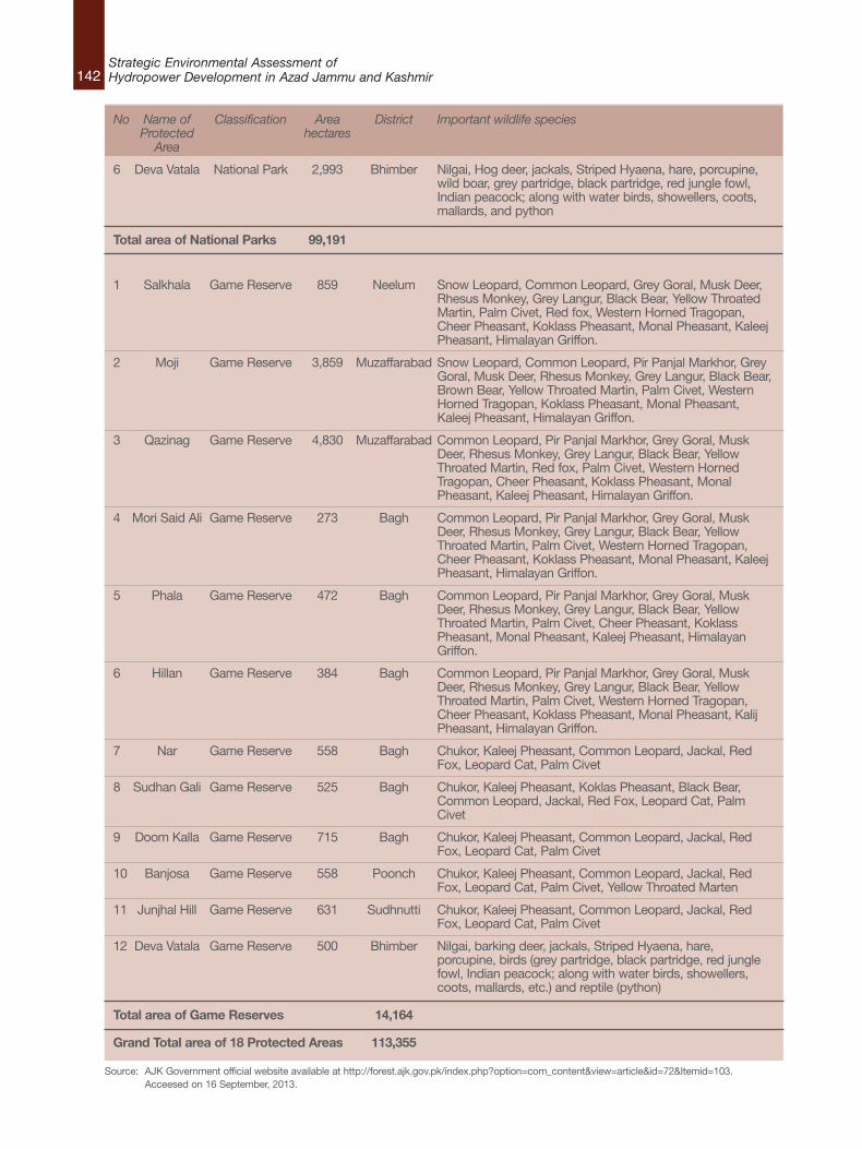
142Strategic Environmental Assessment ofHydropower Development in Azad Jammu and Kashmir
No Name of Classification Area District Important wildlife speciesProtected hectaresArea
6 Deva Vatala National Park 2,993 Bhimber Nilgai, Hog deer, jackals, Striped Hyaena, hare, porcupine,wild boar, grey partridge, black partridge, red jungle fowl,Indian peacock; along with water birds, showellers, coots,mallards, and python
Total area of National Parks 99,191
1 Salkhala Game Reserve 859 Neelum Snow Leopard, Common Leopard, Grey Goral, Musk Deer,Rhesus Monkey, Grey Langur, Black Bear, Yellow ThroatedMartin, Palm Civet, Red fox, Western Horned Tragopan,Cheer Pheasant, Koklass Pheasant, Monal Pheasant, KaleejPheasant, Himalayan Griffon.
2 Moji Game Reserve 3,859 Muzaffarabad Snow Leopard, Common Leopard, Pir Panjal Markhor, GreyGoral, Musk Deer, Rhesus Monkey, Grey Langur, Black Bear,Brown Bear, Yellow Throated Martin, Palm Civet, WesternHorned Tragopan, Koklass Pheasant, Monal Pheasant,Kaleej Pheasant, Himalayan Griffon.
3 Qazinag Game Reserve 4,830 Muzaffarabad Common Leopard, Pir Panjal Markhor, Grey Goral, MuskDeer, Rhesus Monkey, Grey Langur, Black Bear, YellowThroated Martin, Red fox, Palm Civet, Western HornedTragopan, Cheer Pheasant, Koklass Pheasant, MonalPheasant, Kaleej Pheasant, Himalayan Griffon.
4 Mori Said Ali Game Reserve 273 Bagh Common Leopard, Pir Panjal Markhor, Grey Goral, MuskDeer, Rhesus Monkey, Grey Langur, Black Bear, YellowThroated Martin, Palm Civet, Western Horned Tragopan,Cheer Pheasant, Koklass Pheasant, Monal Pheasant, KaleejPheasant, Himalayan Griffon.
5 Phala Game Reserve 472 Bagh Common Leopard, Pir Panjal Markhor, Grey Goral, MuskDeer, Rhesus Monkey, Grey Langur, Black Bear, YellowThroated Martin, Palm Civet, Cheer Pheasant, KoklassPheasant, Monal Pheasant, Kaleej Pheasant, HimalayanGriffon.
6 Hillan Game Reserve 384 Bagh Common Leopard, Pir Panjal Markhor, Grey Goral, MuskDeer, Rhesus Monkey, Grey Langur, Black Bear, YellowThroated Martin, Palm Civet, Western Horned Tragopan,Cheer Pheasant, Koklass Pheasant, Monal Pheasant, KalijPheasant, Himalayan Griffon.
7 Nar Game Reserve 558 Bagh Chukor, Kaleej Pheasant, Common Leopard, Jackal, RedFox, Leopard Cat, Palm Civet
8 Sudhan Gali Game Reserve 525 Bagh Chukor, Kaleej Pheasant, Koklas Pheasant, Black Bear,Common Leopard, Jackal, Red Fox, Leopard Cat, PalmCivet
9 Doom Kalla Game Reserve 715 Bagh Chukor, Kaleej Pheasant, Common Leopard, Jackal, RedFox, Leopard Cat, Palm Civet
10 Banjosa Game Reserve 558 Poonch Chukor, Kaleej Pheasant, Common Leopard, Jackal, RedFox, Leopard Cat, Palm Civet, Yellow Throated Marten
11 Junjhal Hill Game Reserve 631 Sudhnutti Chukor, Kaleej Pheasant, Common Leopard, Jackal, RedFox, Leopard Cat, Palm Civet
12 Deva Vatala Game Reserve 500 Bhimber Nilgai, barking deer, jackals, Striped Hyaena, hare,porcupine, birds (grey partridge, black partridge, red junglefowl, Indian peacock; along with water birds, showellers,coots, mallards, etc.) and reptile (python)
Total area of Game Reserves 14,164
Grand Total area of 18 Protected Areas 113,355
Source: AJK Government official website available at http://forest.ajk.gov.pk/index.php?option=com_content&view=article&id=72&Itemid=103. Acceesed on 16 September, 2013.
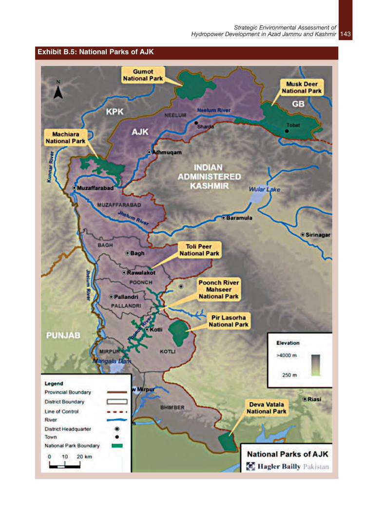
143Strategic Environmental Assessment of
Hydropower Development in Azad Jammu and Kashmir
Exhibit B.5: National Parks of AJK
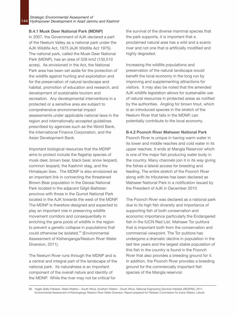
144Strategic Environmental Assessment ofHydropower Development in Azad Jammu and Kashmir
B.4.1 Musk Deer National Park (MDNP)In 2007, the Government of AJK declared a partof the Neelum Valley as a national park under theAJK Wildlife Act, 1975 (AJK Wildlife Act 1975).The national park, called the Musk Deer NationalPark (MDNP), has an area of 528 km2 (130,510acres). As envisioned in the Act, the NationalPark area has been set aside for the protection ofthe wildlife against hunting and exploitation andfor the preservation of natural landscape andhabitat, promotion of education and research, anddevelopment of sustainable tourism andrecreation. Any developmental interventions in aprotected or a sensitive area are subject tocomprehensive environmental impactassessments under applicable national laws in theregion and internationally-accepted guidelinesprescribed by agencies such as the World Bank,the International Finance Corporation, and theAsian Development Bank.
Important biological resources that the MDNPaims to protect include the flagship species ofmusk deer, brown bear, black bear, snow leopard,common leopard, the Kashmir stag, and theHimalayan ibex. The MDNP is also envisioned asan important link in connecting the threatenedBrown Bear population in the Deosai NationalPark located in the adjacent Gilgit-Baltistanprovince with those in the Gumot National Parklocated in the AJK towards the west of the MDNP.The MDNP is therefore designed and expected toplay an important role in preserving wildlifemovement corridors and consequentially inenriching the gene pools of wildlife in the regionto prevent a genetic collapse in populations thatcould otherwise be isolated.89 (EnvironmentalAssessment of Kishenganga/Neelum River WaterDiversion, 2011).
The Neelum River runs through the MDNP and isa central and integral part of the landscape of thenational park. Its naturalness is an importantcomponent of the overall nature and identity ofthe MDNP. While the river may not be critical for
the survival of the diverse mammal species thatthe park supports, it is important that aproclaimed natural area has a wild and a scenicriver and not one that is artificially modified andhighly degraded.
Increasing the wildlife populations andpreservation of the natural landscape wouldbenefit the local economy in the long run byimproving and supplementing attractions forvisitors. It may also be noted that the amendedAJK wildlife legislation allows for sustainable useof natural resources in protected areas as notifiedby the authorities. Angling for brown trout, whichis an introduced species in the stretch of theNeelum River that falls in the MDNP, canpotentially contribute to the local economy.
B.4.2 Poonch River Mahseer National ParkPoonch River is unique in having warm water inits lower and middle reaches and cold water in itsupper reaches. It ends at Mangla Reservoir whichis one of the major fish producing water body inthe country. Many channels join it in its way givingthe fishes a lateral access for breeding andfeeding. The entire stretch of the Poonch Riveralong with its tributaries has been declared asMahseer National Park in a notification issued bythe President of AJK in December 2010.
The Poonch River was declared as a national parkdue to its high fish diversity and importance ofsupporting fish of both conservation andeconomic importance particularly the Endangeredfish in the IUCN Red List. Mahseer Tor putitorathat is important both from the conservation andcommercial viewpoint. The Tor putitora hasundergone a dramatic decline in population in thelast few years and the largest stable population ofthis fish in the country is found in the PoonchRiver that also provides a breeding ground for it.In addition, the Poonch River provides a breedingground for the commercially important fishspecies of the Mangla reservoir.
89. Hagler Bailly Pakistan, Water Matters – South Africa, Southern Waters – South Africa, National Engineering Services Pakistan (NESPAK), 2011,Environmental Assessment of Kishenganga /Neelum River Water Diversion. Report prepared for Pakistan Commission for Indus Waters, Lahore.
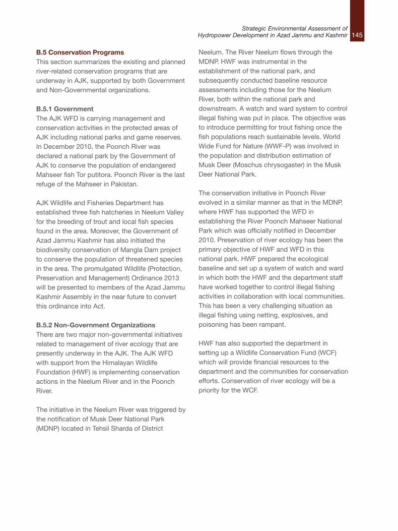
145Strategic Environmental Assessment of
Hydropower Development in Azad Jammu and Kashmir
B.5 Conservation ProgramsThis section summarizes the existing and plannedriver-related conservation programs that areunderway in AJK, supported by both Governmentand Non-Governmental organizations.
B.5.1 GovernmentThe AJK WFD is carrying management andconservation activities in the protected areas ofAJK including national parks and game reserves.In December 2010, the Poonch River wasdeclared a national park by the Government ofAJK to conserve the population of endangeredMahseer fish Tor putitora. Poonch River is the lastrefuge of the Mahseer in Pakistan.
AJK Wildlife and Fisheries Department hasestablished three fish hatcheries in Neelum Valleyfor the breeding of trout and local fish speciesfound in the area. Moreover, the Government ofAzad Jammu Kashmir has also initiated thebiodiversity conservation of Mangla Dam projectto conserve the population of threatened speciesin the area. The promulgated Wildlife (Protection,Preservation and Management) Ordinance 2013will be presented to members of the Azad JammuKashmir Assembly in the near future to convertthis ordinance into Act.
B.5.2 Non-Government Organizations There are two major non-governmental initiativesrelated to management of river ecology that arepresently underway in the AJK. The AJK WFDwith support from the Himalayan WildlifeFoundation (HWF) is implementing conservationactions in the Neelum River and in the PoonchRiver.
The initiative in the Neelum River was triggered bythe notification of Musk Deer National Park(MDNP) located in Tehsil Sharda of District
Neelum. The River Neelum flows through theMDNP. HWF was instrumental in theestablishment of the national park, andsubsequently conducted baseline resourceassessments including those for the NeelumRiver, both within the national park anddownstream. A watch and ward system to controlillegal fishing was put in place. The objective wasto introduce permitting for trout fishing once thefish populations reach sustainable levels. WorldWide Fund for Nature (WWF-P) was involved inthe population and distribution estimation ofMusk Deer (Moschus chrysogaster) in the MuskDeer National Park.
The conservation initiative in Poonch Riverevolved in a similar manner as that in the MDNP,where HWF has supported the WFD inestablishing the River Poonch Mahseer NationalPark which was officially notified in December2010. Preservation of river ecology has been theprimary objective of HWF and WFD in thisnational park. HWF prepared the ecologicalbaseline and set up a system of watch and wardin which both the HWF and the department staffhave worked together to control illegal fishingactivities in collaboration with local communities.This has been a very challenging situation asillegal fishing using netting, explosives, andpoisoning has been rampant.
HWF has also supported the department insetting up a Wildlife Conservation Fund (WCF)which will provide financial resources to thedepartment and the communities for conservationefforts. Conservation of river ecology will be apriority for the WCF.
146Strategic Environmental Assessment ofHydropower Development in Azad Jammu and Kashmir
C.1 Overview of AJK’s Socioeconomic SettingAJK is an independent political entity withinPakistan. It has its own parliamentary governmentheaded by the President. Administratively, AJK isdivided into three divisions and 10 districts withMuzaffarabad city as the capital of the state. Thedistricts are further divided into tehsils, unioncouncils and villages. An administrative map ofAJK illustrating the districts and main towns isgiven in Exhibit C.1. The divisions, districts andtehsils of AJK are listed in Exhibit C.2.
The topography of AJK is dominated by hilly andmountainous terrain with the districts of Neelum,Muzaffarabad, Bagh, Sudhnoti and Poonchlocated at the foot hills of the Himalayas. Mainrivers running through the state include theNeelum, Jhelum and Poonch rivers. The climateof AJK is sub-tropical to temperate highland typewith an average yearly rainfall of 1,300 mm. Theelevation from sea level ranges from 360 meters inthe plains in the south to 6,325 meters in thehighest mountains in the north.
C.1.1 DemographyAccording to the last census conducted inPakistan in 1998, AJK had a population of 2.9million which has increased to 4.25 million in2013.90 Only 13% of the population resides inurban centres whereas the rest is rural.91 Thepopulation density is 390 persons per squarekilometer. Exhibit C.3 presents official data ondistrict population, population density, growthrates and household–size.
C.1.2 LivelihoodsThe majority of the rural population depends onforestry, livestock, agriculture and informalemployment to eke out its subsistence. Nationalaverage per capita income has been estimated tobe USD 1,254. Unemployment ranges from 9 to13 %.92
Agriculture, forestry, livestock and related servicesectors is the main source of income whichaccounts for 30 to 40 % of the householdearnings. Area under cultivation is around 478,040acres, almost 13 % of the total geographical area.Majority of the cultivable area, that is 92%, is rain-fed. About 89 % households have very small landholdings between one to two acres. Major cropsare maize, wheat and rice whereas other cropsgrown in the area include grams, pulses (redkidney beans), vegetables and oil-seeds. Majorfruits production includes apple, pears, apricotand walnuts.
Employment (both government services andprivate), businesses (including cottage industry),labour and remittances received by familymembers working abroad form the remainingsources of income.
Appendix C: Socio-Economic Baseline: Background Information
90. The last census of Pakistan was conducted in 1998. The next census, scheduled for 2008, could not be held. Therefore, the demographic informationfollowing 1998 is based on surveys and estimated on the basis of intercensal growth rates.
91. Population projection for 2013 based on population and growth rate recorded in the 1998 Census.92. AJK at a Glance 2010, www.pndajk.gov.pk/Documents/Book%202011.doc (Date Accessed: September 13, 2013)�
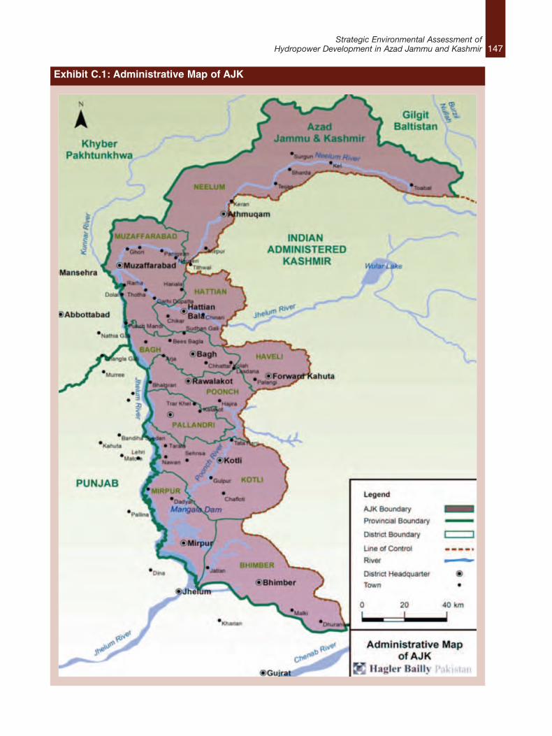
147Strategic Environmental Assessment of
Hydropower Development in Azad Jammu and Kashmir
Exhibit C.1: Administrative Map of AJK
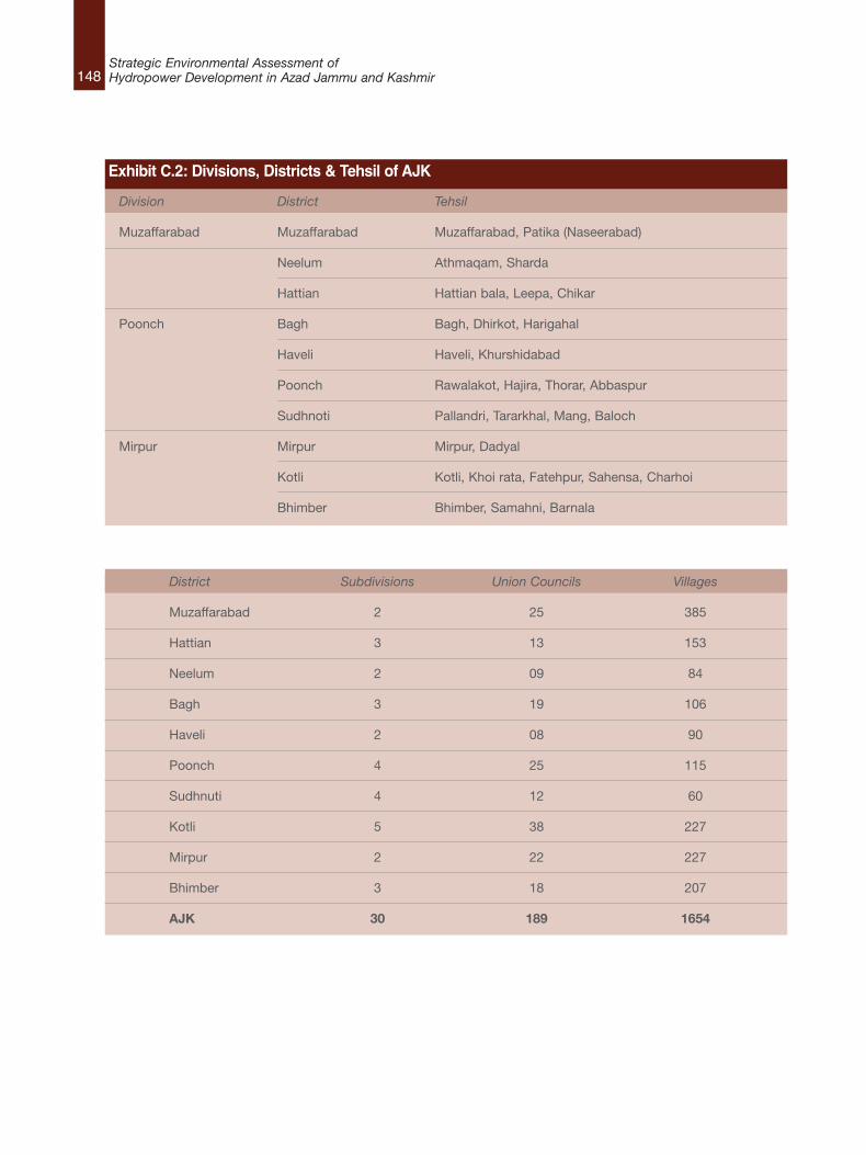
148Strategic Environmental Assessment ofHydropower Development in Azad Jammu and Kashmir
Division District Tehsil
Muzaffarabad Muzaffarabad Muzaffarabad, Patika (Naseerabad)
Neelum Athmaqam, Sharda
Hattian Hattian bala, Leepa, Chikar
Poonch Bagh Bagh, Dhirkot, Harigahal
Haveli Haveli, Khurshidabad
Poonch Rawalakot, Hajira, Thorar, Abbaspur
Sudhnoti Pallandri, Tararkhal, Mang, Baloch
Mirpur Mirpur Mirpur, Dadyal
Kotli Kotli, Khoi rata, Fatehpur, Sahensa, Charhoi
Bhimber Bhimber, Samahni, Barnala
Exhibit C.2: Divisions, Districts & Tehsil of AJK
District Subdivisions Union Councils Villages
Muzaffarabad 2 25 385
Hattian 3 13 153
Neelum 2 09 84
Bagh 3 19 106
Haveli 2 08 90
Poonch 4 25 115
Sudhnuti 4 12 60
Kotli 5 38 227
Mirpur 2 22 227
Bhimber 3 18 207
AJK 30 189 1654
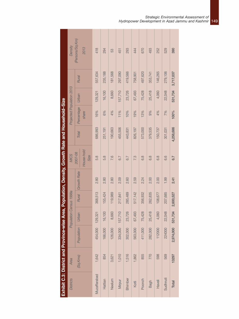
149Strategic Environmental Assessment of
Hydropower Development in Azad Jammu and Kashmir
Exhibit C.3: D
istrict and
Province-wise Area, Pop
ulation, Density, G
rowth Rate and Hou
seho
ld–S
ize
Districts
Muzaffarabad
Hattian
Neelum
Mirpur
Bhimber
Kotli
Poonch
Bagh
Haveli
Sudhnuti
Total
Density
(Persons/Sq.Km)
2013
418
294
53
451
293
444
670
493
252
529
390
MICS
2007-08
House-hold
Size 5.8
5.8
7.6
6.7
6.7
7.3
6.8
6.8
6.8
6.6
6.7
Area
(Sq.Kms)
1,642
854
3,621
1,010
1,516
1,862
855
770
598
569
13297
Population Census 1998a
Population
Urban
Rural
Growth Rate
454,000
129,321
368,513
2.80
166,000
16,100
155,424
2.80
126,000
8,660
119,989
2.80
334,000
157,710
217,841
2.09
302,000
23,726
285,489
2.60
563,000
67,493
517,142
2.59
411,000
75,428
356,932
2.24
282,000
25,418
262,835
2.00
112000
4,060
108,677
2.00
224000
22,048
207,685
1.99
2,974,000
531,734
2,600,527
2.41
Projected Population 2013
Total
Percentage
Urban
Rural
share
686,993
16%
129,321
557,634
251,191
6%16,100
235,188
190,663
4%8,660
181,568
455,506
11%
157,710
297,090
443,831
10%
23,726
419,566
826,197
19%
67,493
758,901
573,000
13%
75,428
497,620
379,535
9%25,418
353,741
150,737
4%4,060
146,265
301,031
7%22,048
279,106
4,258,686
100%
531,734
3,717,037
150Strategic Environmental Assessment ofHydropower Development in Azad Jammu and Kashmir
C.1.3 Physical InfrastructureRoads and air transport are the only modes oftransportation in AJK. The total length of roads inthe state is 12,719 km of which 6,390 km ismetalled and the remaining 6,329 km are fair-weather roads.
The Government of AJK in collaboration with theCivil Aviation Authority (CAA) of Pakistan hasconstructed two small airports in Muzaffarabadand Rawalakot cities in order to provide easy andquick modes of travel.
In 2010, the installed grid capacity was 438.30Megavolt Ampere (MVA). Transmission lines of25,328 km in length have been extended to 1,649villages out of a total of 1,654 villages with 3.5million people having access to electricity in 2010.The per capita electricity consumption in 2010was 284.5 kWh.93
About 82% of the urban population and 44% ofrural population had access to piped water supplythrough house connections and public standposts in 2010.
C.1.4 Social InfrastructureAccess to health facilities in AJK is inadequate.According to estimates in 2010, approximately2,249 hospital beds were available in 19 hospitalsaveraging 1 bed per 1,762 persons. The totalnumber of doctors, including administrativedoctors, health mangers and dentists is 781 outof which 450 are medical officers, 67 dentalsurgeons, 212 specialists and 52 healthmanagers. The total numbers of dispensaries andrural health centers is 310 and 34 respectively,together making up 408 beds.94
The literacy rate in 2010 rose to 64 % comparedto 55 % recorded in the 1998 census.95 Educationis among the priorities of the Government of AJK.About 26% of its total recurring budget besides 8% of the total development budget is allocated tothis sector.
C.1.5 Neelum DistrictUntil 2005 Neelum District was part ofMuzaffarabad district. The district isadministratively divided into two tehsils namelySharda and Athmuqam. With an area of 3,621square kilometers, it is the largest district of AJK.The population of Neelum District constitutes only4% of the population of AJK making it one of thesparsely populated districts. According to the1998 census, the population of Neelum Districtwas 126,000 whereas the projected population(based on the annual growth rate for Neelumdistrict) in 2013 is 190,663. The estimatedpopulation for 2013 shows an increase by 1.5times compared to 1998. Official data on districtpopulation from 1998 and 2013, populationdensity, growth rates and household–size is givenin Exhibit C.3.
More than 80% of the population of NeelumDistrict resides within 3 km of the river,96 mainlybecause traditional access routes in the NeelumValley are located closer to the river, typical invalleys with steep slopes. The shape of the valleyalso affects the population distribution: where thevalley is narrow, population is relatively low andwhere it is wide, it is relatively high. The averagehousehold size in Neelum District is 7.6. Seasonalmigration in the summer to access the alpinegrazing grounds at higher elevations in the valleyand in winter to urban areas downstream foremployment is common. However, highermigration levels can be observed in Sharda Tehsiland some union councils of Athmuqam Tehsil.
Majority of the population in the district dependson daily wages, forestry, livestock and agriculturefor its subsistence. Women have limitedopportunities to work outside their homes, andthe share of women in the employed workforce isnegligible.
Agriculture is mostly based on rainfall and waterprovided by irrigation channels fed by tributaries
93. AJK at a Glance, 2010, www.pndajk.gov.pk/Documents/Book%202011.doc (Date Accessed: September 13, 2013)�94. Ibid95. Ibid96. Of which 80% live within 1 km of the river.
151Strategic Environmental Assessment of
Hydropower Development in Azad Jammu and Kashmir
or the side streams. Maize, wheat and paddy arethe major food crops in the Neelum District.Linkages of the people’s livelihoods to the NeelumRiver are limited to river-based tourism andrelated activities, such as sport fishing. The riverserves as the main attraction for the touristsfrequenting Neelum Valley and tourism-basedactivities, such as angling for brown trout,generate employment opportunities for the localpeople.97 The river is used for transportation oftimber. However, timber harvesting in sectionsthat fall in the Musk Deer National Park isrestricted as the Government of AJK is graduallymoving towards sustainable forestry regimes.Compared to the urban centres in AJK, such asMuzaffarabad, infrastructure and facilitiesavailable for visitors in the rural areas in theNeelum Valley are relatively limited. The mainreason for this is the backdrop of military conflictclose to the LoC hindering the development of thetourism potential of the valley. When comparedwith similar valleys in other provinces of Pakistanlocated far from the borders such as Kaghan andSwat, the Neelum Valley has yet to realize itstourism potential.
There is a district headquarter (DHQ) hospital inAthmuqam and a tehsil headquarter hospital(THQ) in Kel. Besides these, dispensaries, basichealth units (BHUs) and rural health centres(RHCs) are accessible.
C.1.6 Muzaffarabad DistrictMuzaffarabad District consists of Muzaffarabadcity, the capital of AJK, and suburban areaslocated at the confluence of Jhelum and Neelumrivers. It is the second largest district of AJK interms of population and third area-wise. Thepopulation of Muzaffarabad District constitutes16% of the population of AJK, making it one ofthe densely populated districts. The district isadministratively divided into two tehsils. Withrespect to the rural-urban divide, Muzaffarabad isthe second largest district in terms of urbanpopulation following Mirpur District. According to
the Multiple Indicator Cluster Survey (MICS) 2007-08,98 the average household size in Muzaffarabaddistrict was 5.8 which is lower than the averagehousehold size reported in the 1998 census (7.1for both urban and rural). Official data on districtpopulation (1998 and 2013), population density,growth rates and household-size is given inExhibit C.3.
People of Muzaffarabad have diverse means oflivelihood. Farming, forestry and livestock rearingare the main occupations, particularly among ruralhouseholds. Poultry farming is also common and,ponies and donkeys are kept for carrying load tohigher altitude areas. Among the mountains arevalleys and terraces used for cultivation. Maincrops are maize, wheat, rice, oil seed, potato,pulses and a variety of vegetables. The area isfamous for fruits such as apple, walnut, pear,plum and apricot. There is no extensive canalsystem and farming is largely dependent on rainwater and small channels connected to perennialwater sources. Almost 59% of the district area iscovered with forest and is a major source ofincome (such as timber, firewood, fruits).
Muzaffarabad is also the main trade centre ofAJK. Due to the topography of the area, it is notpossible to establish large industrial units,however, the cottage industry; mainly carpetweaving, furniture making, wood carving, garmentmaking and embroidery work thrives in the area.There are a few textile centers which produce bedsheets and coarse cloth.
Employment in government offices and in thearmy as well as overseas employment is quitecommon in Muzaffarabad city. In-countryseasonal migration for employment is alsopracticed by a large number of people. Special Communication Organization (SCO)operates an extensive telephone network in thedistrict and all main towns in the district havetelephone connectivity. Cellular phone services,with considerable coverage in all major towns arealso available.
97. Hagler Bailly Pakistan, (HBP) 2011. Environmental Assessment of Kishenganga/Neelum River Water Diversion. Report prepared for Pakistan Commissionfor Indus Waters. Lahore: Hagler Bailly Pakistan.
98. AJK at a Glance 2010, www.pndajk.gov.pk/Documents/Book%202011.doc (Date Accessed: September 13, 2013)�
152Strategic Environmental Assessment ofHydropower Development in Azad Jammu and Kashmir
Muzaffarabad is linked with Pakistan’s nationalgrid system. The distribution network within thecity and rest of the district is the responsibility ofAJK Electricity Department. Most of the villagesand towns are quite well serviced in terms ofelectricity.
C.1.7 Bagh DistrictBagh District is administratively divided into threetehsils. The population of Bagh Districtconstitutes only 9% of the population of AJKhowever the population density is highercompared to that of AJK (Exhibit 4.3). Accordingto the 1998 census, the population of BaghDistrict was 282,000 whereas the projectedpopulation (based on the annual growth rate forBagh District) in 2013 is 379,535. Official data ondistrict population (1998 and 2013), populationdensity, growth rates and household–size is givenin Exhibit C.3.
The major crops of the district are maize andwheat but at some places rice, gram, bajra andjawar are also cultivated. Pulses are also grown inthe district. Buffalos and sheep/goat are reared inalmost every home for milk and other dairyproducts. Ponies and donkeys are used forcarrying load. Main trade centers of the districtare at Dhirkot, Bagh and Kahuta. Wool spinningon hand looms is carried out throughout thedistrict. The articles made from these hand looms,are for domestic use only. Since there is noindustry in the district, all essential commoditieslike textiles, leather goods and other items of dailyuse are imported from various markets ofPakistan. The major export of the district is apple.
The district is connected with Rawalpindi by tworoads, Bagh – Tain Dhalkot - Kotli Sattian Roadand Bagh-Kohala-Murree road. Bagh is alsoconnected with Kohala, Haveli via Suddhan Galiand Mallot Las Dana through metalled roads. Atotal of 3,187 km of link roads (metalled and dirttracks) have been constructed under the LocalGovernment and World Food Programme (WFP)projects.
Special Communication Organization (SCO)operates an extensive telephone network in thedistrict and all main towns have telephoneconnectivity. There are 8 digital exchanges, 12non-digital exchanges and 2 under constructiondigital exchanges in District Bagh. Cellular phoneservices with considerable coverage have alsobecome available after the 2005 majorearthquake.
Bagh is linked with Pakistan’s national gridsystem. The distribution network within the cityand rest of the district is provided by the AJKElectricity Department. According to the censusof 1998, overall 68 % of the district area isprovided with electricity. In rural areas thepercentage stood at 66 % and for urban it was97%.
C.1.8 Poonch DistrictPoonch District is administratively divided intofour tehsils namely Rawalakot, Hajira, Thorar,Abbaspur. Area wise, the district is one of thesmaller districts in AJK. However, the populationdensity of the district is 670 persons per squarekilometer, the highest in AJK. The reason for highpopulation density is the mountainous terrain.Official data on district population (1998 and2013), population density, growth rates andhousehold–size is given in Exhibit C.3.
Means of livelihood in Poonch District includefarming, livestock, poultry, government service(both civil and military), business and overseasemployment. Industry is minimal in terms ofcontributions towards livelihoods. In-countryseasonal migration for employment is verycommon.
Poonch District is connected to other districts ofAJK and Pakistan by road. According to 2005statistics, there were a total of 1,822 km of roadsin district Poonch with a break up of 617 km ofmetalled and 1,205 km of fair weather roads.Major towns of the district have telephoneconnectivity. Similarly cellular phone network isalso available in the district. The district is linked
153Strategic Environmental Assessment of
Hydropower Development in Azad Jammu and Kashmir
with Pakistan’s national grid system, however, theresponsibility of distribution lies with theElectricity Department of AJK. According to thecensus of 1998, overall 79% of the district areahad access to electricity. In rural and urban areas,the percentage stood at 76% and 98%respectively.
C.1.9 Sundhoti DistrictSudhnoti District is the smallest of all the districtsin AJK in terms of area and is home to only sevenpercent of AJK’s population. Official data ondistrict population (1998 and 2013), populationdensity, growth rates and household–size is givenin Exhibit C.3. Administratively the district isdivided into four tehsils, Pallandri, Mang, Balochand Trarkhal. Pallandri is the district headquarters.
Roads are the main mode of transportation in thedistrict. The total metalled road network in thedistrict is 504 km. Transport facilities are availablein the form of passenger vans, taxis, jeeps andbuses. The district does not have the facility of ageneral post office (GPO) but 34 extradepartmental branches of post offices exist. Thereare 14 telephone exchanges in the district.
C.1.10 Kotli DistrictKotli District is the second largest district in AJKarea-wise and the largest in terms of population.The district houses 19% of AJK’s total population.Official data on district population (1998 and2013), population density, growth rates andhousehold–size is given in Exhibit C.3. It is dividedin four subdivisions, Kotli, Fatehpur Thakiala,Sehnsa and Charhoi. Kotli, the districtsheadquarter is located at a distance of 114 kmfrom Rawalpindi/Islamabad.
Roads are the main mode of transportation in thedistrict. Total metalled road network in the districtis 1,014 km. Transport facilities such aspassenger vans, taxis, jeeps and buses are usedfor travelling within the district and other districts.The installed grid capacity in the district is 65MVA. About 4,598 km of transmission lines havebeen extended to 230 villages. The district has
one general post office (GPO) and 48 extradepartmental branches of post offices. There are25 telephone exchanges functioning in thedistrict.
C.1.11 Mirpur DistrictMirpur District comprises of 11% of the totalpopulation of AJK. It is administratively divided inthree tehsils, Mirpur, Dudyal and Chakswari.Mirpur, the district headquarter is situated at anelevation of 459 m above sea level. It is linkedwith the main Peshawar-Karachi Grand Trunkroad at Deena, a small town about 15 km short ofJhelum city. Official data on district population(1998 and 2013), population density, growth ratesand household–size is given in Exhibit C.3.
The district comprises of both mountainousterrain and plains. Its hot climate and othergeographical conditions closely resemble those ofJhelum and Gujrat, the adjoining districts ofPakistan. The people of the area are mainlyassociated with agriculture. As it adjoins theindustrial cities of Pakistan, the government ofAJK has successfully endeavoured to develop itas an industrial place and promote privateinvestment for establishing textile, vegetable,ghee, garments, scooters, cosmetics and manyother industries. Mirpur city is well planned andbuildings are of modem design. It has rapidlydeveloped into an industrial city. All the basicamenities of life such as colleges, hospitals,banks, shopping centers, hotels, hostels,telephone; and telegraph units are available here.
The total metalled road network in the district is1,699 km. The main mode of transport in thedistrict is by road. Transport facilities are in theform of passenger vans, rickshaws, taxis, jeepsand buses that traverse different parts of thedistrict. The installed grid capacity in the district is130 MVA. About 2,006 km transmission lines havebeen extended to 231 villages. The district hasone general post office (GPO) and 40 extradepartmental branches of post offices. There are15 telephone exchanges functioning in thedistrict.

154Strategic Environmental Assessment ofHydropower Development in Azad Jammu and Kashmir
C.1.12 Bimber DistrictFormerly a subdivision of Mirpur District, Bhimberwas administratively declared as an independentdistrict in 1996. The district is very rich inarchaeology and wild life, and panoramic vistas.Bhimber town is located at a distance of 50 kmfrom Mirpur and 166 km from Rawalpindi. Thistown is connected both with Mirpur and Gujratthrough black top roads.
The population of the district represents 10% ofthe total population of AJK. Official data ondistrict population (1998 and 2013), populationdensity, growth rates and household–size is givenin Exhibit 4.3. The people of the area are mainlyassociated with agriculture and livestock.
The total metalled road network in the district is401 km. Roads are the main mode oftransportation throughout the district. Transportfacilities are available in the form of rickshaws,taxis, jeeps and buses. The district does not havethe general post office (GPO) facility, however, 29extra departmental branches of post offices exist.Seven telephone exchanges are functioning in thedistrict. The installed grid capacity is 52 MVA andabout 1,931 km of transmission lines have beenextended to 208 villages.

4 Rules of Strategic Environmental Assessment
Produced with the financial support of the Embassy of the Kingdom of the Netherlands (EKN).