HYDROGRAPHIC SURVEY STANDARDS AND … · by a Level 1 Certified Professional in Hydrographic...
14
HYDROGRAPHIC SURVEY STANDARDS AND DELIVERABLES A306835 Page 1 of 14 TABLE OF CONTENTS 1. HYDROGRAPHIC SURVEY METHODOLOGY............................................................ 3 2. HYDROGRAPHIC SURVEY REFERENCE STANDARDS ........................................... 3 3. HYDROGRAPHIC SURVEY CRITERIA ....................................................................... 3 3.1 HYDROGRAPHIC SURVEYS OVER NON GAZETTED NAVIGABLE WATERS*: ......................................................................................................... 3 3.2 HYDROGRAPHIC SURVEYS OVER GAZETTED NAVIGABLE WATERS*:...... 4 3.3 PROGRESS SURVEYS..................................................................................... 4 4. HYDROGRAPHIC SURVEY DELIVERABLES ............................................................. 4 4.1 CHARTS, DRAWINGS AND SURVEY DATA .................................................... 5 4.2 SURVEY REPORTS .......................................................................................... 6 5. PROCESS OWNER ..................................................................................................... 7 6. APPENDIX A................................................................................................................ 8 6.1 LOCATION DIAGRAM ....................................................................................... 8 6.2 GENERAL NOTES ............................................................................................ 8 6.3 LEGEND ............................................................................................................ 9 6.4 GEODETIC PARAMETERS............................................................................. 10 6.5 SCALE REFERENCED TO CHART SIZE........................................................ 11 6.6 VERTICAL CONTROL ..................................................................................... 11 6.7 SURVEY UNCERTAINTY ................................................................................ 11 6.8 SURVEY APPROVAL ...................................................................................... 12 6.9 CHART TITLE AND REVISIONS ..................................................................... 13 6.10 PROJECT INFORMATION .............................................................................. 13
Transcript of HYDROGRAPHIC SURVEY STANDARDS AND … · by a Level 1 Certified Professional in Hydrographic...

HYDROGRAPHIC SURVEY STANDARDS AND DELIVERABLES
A306835 Page 1 of 14
TABLE OF CONTENTS 1. HYDROGRAPHIC SURVEY METHODOLOGY ............................................................ 3
2. HYDROGRAPHIC SURVEY REFERENCE STANDARDS ........................................... 3
3. HYDROGRAPHIC SURVEY CRITERIA ....................................................................... 3
3.1 HYDROGRAPHIC SURVEYS OVER NON GAZETTED NAVIGABLE WATERS*: ......................................................................................................... 3
3.2 HYDROGRAPHIC SURVEYS OVER GAZETTED NAVIGABLE WATERS*: ...... 4
3.3 PROGRESS SURVEYS..................................................................................... 4
4. HYDROGRAPHIC SURVEY DELIVERABLES ............................................................. 4
4.1 CHARTS, DRAWINGS AND SURVEY DATA .................................................... 5
4.2 SURVEY REPORTS .......................................................................................... 6
5. PROCESS OWNER ..................................................................................................... 7
6. APPENDIX A ................................................................................................................ 8
6.1 LOCATION DIAGRAM ....................................................................................... 8
6.2 GENERAL NOTES ............................................................................................ 8
6.3 LEGEND ............................................................................................................ 9
6.4 GEODETIC PARAMETERS ............................................................................. 10
6.5 SCALE REFERENCED TO CHART SIZE ........................................................ 11
6.6 VERTICAL CONTROL ..................................................................................... 11
6.7 SURVEY UNCERTAINTY ................................................................................ 11
6.8 SURVEY APPROVAL ...................................................................................... 12
6.9 CHART TITLE AND REVISIONS ..................................................................... 13
6.10 PROJECT INFORMATION .............................................................................. 13

HYDROGRAPHIC SURVEY STANDARDS AND DELIVERABLES
A306835 Page 2 of 14
DOCUMENT AMENDMENT TABLE
Version Prepared By Date Amendments
2 Marine Operations Administrator
9 June 2015 Minor Amendments
3 Marine Operations Administrator
1 September 2015 Minor Amendments
4 Marine Operations Administrator
15 October 2015 Annex A added
5 Dredging Manager 24 November 2016 Survey Report requirements modified
6 Dredging/Survey Manager
20 November 2017 Compliance & Reporting requirements modified
HYDROGRAPHIC SURVEY STANDARDS AND DELIVERABLES
A306835 Page 3 of 14
1. HYDROGRAPHIC SURVEY METHODOLOGY
The PPA requires any hydrographic survey to be conducted with the methodology using the
Global Navigation Satellite System to conduct Ellipsoidally Referenced Surveying.
A PPA Port’s unique ‘Hydroid’ shall be used as a separation model for the determination of
Chart Depths. Where available, PPA shall provide Proponents with the appropriate ‘Hydroid’.
Where a Port’s ‘Hydroid’ is not available, hydrographic surveys shall apply the AUSGEOID
09 to LAT offset at a predetermined location to propagate LAT to the survey location.
2. HYDROGRAPHIC SURVEY REFERENCE STANDARDS
These PPA Hydrographic Survey Standards are, in part, derived from the guidelines
contained in:
IHO SP 44 5th Edition (special order) and
Ports Australia Survey principles – Version 1.5 (Nov 2012)
Important Note: Where a Proponent cannot meet the PPA Hydrographic Survey Standards, the Proponent shall seek a formal
exemption from PPA to deviate from these Standards prior to the commencement of any hydrographic survey. Avoidance of
obtaining such an exemption may lead to the rejection of the survey deliverables.
3. HYDROGRAPHIC SURVEY CRITERIA
All surveys shall be conducted applying the hydrographic survey industry best practise and
will meet the requirements of a Ports Australia Class ‘A’ hydrographic survey.
All surveys conducted over gazetted and non-gazetted navigable waters shall be approved
by a Level 1 Certified Professional in Hydrographic Surveying (CPHS1), certified by the
Australasian Hydrographic Surveyors Certification Panel (AHSCP). In addition, the CPHS1
must have demonstrated experience in conducting surveys within a port environment and
application for navigational safety.
In addition to the requirements of a Ports Australia Class ‘A’ hydrographic survey, a
Proponent shall at a minimum conduct its hydrographic surveys to achieve the following
criteria in its final processed survey data:
3.1 Hydrographic surveys over non gazetted navigable waters*:
A total vertical uncertainty of plus or minus 0.1 metre at a 95% confidence level
A total horizontal uncertainty of plus or minus 0.5 metre at a 95% confidence level
0.5m Object detection, (minimum of 3 hits in the along track direction)
HYDROGRAPHIC SURVEY STANDARDS AND DELIVERABLES
A306835 Page 4 of 14
100% coverage over the survey area as predetermined by the PPA
Final processed data shall be derived from the shallowest sounding in 1 metre BIN from a 0.5m statistically derived surface from the full density raw survey data
3.2 Hydrographic surveys over gazetted navigable waters*:
A total vertical uncertainty of plus or minus 0.1 metre at a 95% confidence level
A total horizontal uncertainty of plus or minus 0.5 metre at a 95% confidence level
0.5m Object detection (minimum of 3 hits in the along track direction)
200% coverage over the surveyed area of the gazetted navigable waters
Final processed data shall be derived from the shallowest sounding in 1 meter BIN from a 0.25m statistically derived surface from the full density raw survey data
* Note: Gazetted navigable waters are deemed to be Channels, Berth Pockets, Swing Basins, etc. as depicted on the
AUS Charts and its revisions or as determined by the PPA.
3.3 Progress surveys.
Where a Proponent carries out works that might affect the depths within a PPA
predetermined survey area, the Proponent shall at a minimum conduct monthly progress
surveys over the whole predetermined survey area. The Proponent shall at a minimum
conduct its hydrographic surveys to achieve the following criteria in its final processed
progress survey data:
A total vertical uncertainty of plus or minus 0.1 metre at a 95% confidence level
A total horizontal uncertainty of plus or minus 0.5 metre at a 95% confidence level
0.5m Object detection, (minimum of 3 hits in the along track direction)
100% coverage over the survey area as predetermined by the PPA and
Final processed data shall be derived from the shallowest sounding in 1 metre BIN from a 0.25m statistically derived surface from the full density raw survey data
4. HYDROGRAPHIC SURVEY DELIVERABLES
The proponent shall provide the PPA for all hydrographic surveys the following Hydrographic
Survey Deliverables and within the time period stated:

HYDROGRAPHIC SURVEY STANDARDS AND DELIVERABLES
A306835 Page 5 of 14
4.1 Charts, Drawings and Survey Data
One (1) copy of the survey charts in AutoCAD (*.dwg) format
One (1) digital copy of the survey charts in PDF (*.pdf) format
One (1) digital copy of all raw survey data, calibration reports and logs
A digital copy of all processed hydrographic survey data:
One (1) digital copy of the final processed hydrographic survey data of the shallowest depths in 1.0 metre BINs with the horizontal position of the shallowest depth preserved from the statistically derived surface.
One (1) digital copy of the final processed hydrographic survey data of the shallowest depths in 1.0 metre GRID.
One (1) digital copy of all data deleted from the raw survey data.
Three (3) copies of paper survey charts duly signed by the supervising CPHS Level 1 surveyor as being representative of the final processed hydrographic survey data
Survey charts shall:
Be plotted on A1 size sheet format
Be scaled at 1:2,500 or as specified by PPA
Consist of depth clashed labels at the appropriate scale from the shallowest depth in a 1 metre x 1 metre BIN; Note: not GRID
Contain depth labels rounded to the nearest decimetre
Contain contours at appropriate intervals
Contain all information as specified in Appendix A
Address all of the requirements outlined in Ports Australia requirements to achieve a Class ‘A’ Survey
All charts or drawings shall include any infrastructure within or near the survey area,
including but not limited to wharf structures, fenders, aids to navigation, etc.
All charts or drawings shall be in metres, georeferenced to GDA94 and projected in UTM
to MGA Zone 50.

HYDROGRAPHIC SURVEY STANDARDS AND DELIVERABLES
A306835 Page 6 of 14
4.2 Survey Reports
Important Note: PPA requires a comprehensive hydrographic survey report that comprehensively explains how the
survey was conducted, and the final survey deliverables derived at. PPA takes into consideration the correctness of the
report when evaluating the quality of the hydrographic survey data and the accuracy of the report and reliability of claims
made. Failure to provide an acceptable report may lead to rejection of the survey deliverables or the application of a
negative tolerance to the horizontal and vertical accuracy of the processed survey data.
Survey Reports shall address and contain at a minimum:
The survey methodology conducted by the Proponent including all personnel, procedures, equipment, software and data filters employed during the survey.
A concise description over all survey work conducted.
Important Note: The report shall describe how all survey work was actually conducted. Only a reference of the survey
work being compliant to a pre-survey prepared work method statement is not acceptable.
All field reports.
Photographic evidence of permanent and temporary installations of equipment employed during the survey.
Check measurements against official bench marks including results and subsequent adjustments and calibrations.
All applied offsets on the survey vessel from GPS receiving antenna to transducers in figures and diagram.
Survey data processing methodology.
Survey data quality control, including a traceable connection between real time checks and calibrations with any data post processed using Post Processed Kinematic or Precise Pont Positioning techniques.
Apriori assessment of accuracy.
Proof that requirements and accuracy has been achieved through checks, calibrations and ongoing QC.
A statement of the file name(s) of the final processed survey data and drawings.
A statement on the quantity of materials dredged to date, if applicable.
A signed statement by the CPHS Level 1 Surveyor that the hydrographic survey and its processes was conducted under his or hers direct supervision.
A signed approval statement by a CPHS level 1 surveyor that the Hydrographic Survey Deliverables are in compliance with these PPA Hydrographic Survey Standards.

HYDROGRAPHIC SURVEY STANDARDS AND DELIVERABLES
A306835 Page 7 of 14
The report shall include a diagram to an appropriate scale indicating the bounds of the survey in relation to its surrounds, including the relative extents of 100% and 200% coverage areas.
The Hydrographic Survey Deliverables for all hydrographic surveys, other than progress
surveys, shall be provided to the PPA no later than 4 weeks after the completion of the
field work for all hydrographic surveys.
For progress surveys, the Proponent shall provide to the PPA the Hydrographic Survey
Deliverables within the first week following the month that the progress survey has been
conducted for.
5. PROCESS OWNER
The General Manager of Operations has overall responsibility for this procedure.
Date approved: 05 January 2018 Review date: 05 January 2019
Version: 6 Approved by: GMO

HYDROGRAPHIC SURVEY STANDARDS AND DELIVERABLES
A306835 Page 8 of 14
6. APPENDIX A
Information to be included on each drawing:
6.1 Location Diagram
Sample:
6.2 General Notes
Survey period from / / to / /
Survey Vessel details:
Transducer installation: (Hull Mounted/Over side Mount)
Survey Equipment and Software details:
Survey Report reference:
Survey Data reference:

HYDROGRAPHIC SURVEY STANDARDS AND DELIVERABLES
A306835 Page 9 of 14
Sample:
6.3 Legend
Depth Labels details:
Contour details:
Soundings and Features colour legend:
Sample:

HYDROGRAPHIC SURVEY STANDARDS AND DELIVERABLES
A306835 Page 10 of 14
6.4 Geodetic Parameters
Coordinate system
Geodetic Datum
Semi Major Axis
Inverse Flattening
Projection
Central Meridian
Reference Latitude
Scale Factor
False Easting
False Northing
Ellipsoid
Sample:
HYDROGRAPHIC SURVEY STANDARDS AND DELIVERABLES
A306835 Page 11 of 14
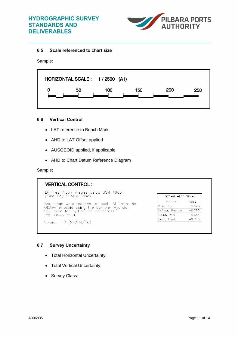
6.5 Scale referenced to chart size
Sample:
6.6 Vertical Control
LAT reference to Bench Mark
AHD to LAT Offset applied
AUSGEOID applied, if applicable.
AHD to Chart Datum Reference Diagram
Sample:
6.7 Survey Uncertainty
Total Horizontal Uncertainty:
Total Vertical Uncertainty:
Survey Class:

HYDROGRAPHIC SURVEY STANDARDS AND DELIVERABLES
A306835 Page 12 of 14
Sample:
6.8 Survey Approval
CPHS1 Details:
Client Details:
Sample:

HYDROGRAPHIC SURVEY STANDARDS AND DELIVERABLES
A306835 Page 13 of 14
6.9 Chart Title and Revisions
Sample:
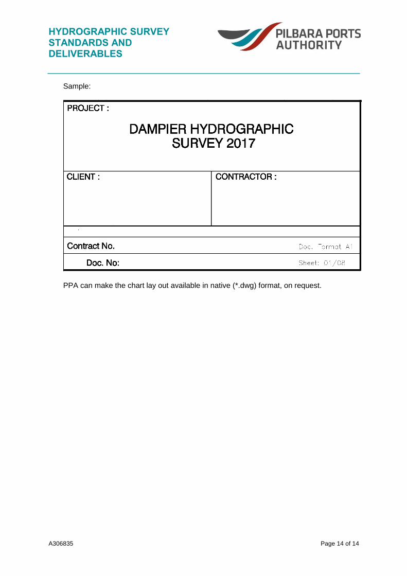
6.10 Project Information
Project Name
Client
Survey Contractor
Drawing and Sheet Number
Chart Format
HYDROGRAPHIC SURVEY STANDARDS AND DELIVERABLES
A306835 Page 14 of 14
Sample:
PPA can make the chart lay out available in native (*.dwg) format, on request.