HYDROFEST 2015 - ths.org.uk · 23-Apr-15 Page 1 HYDROFEST 2015 The Hydrographic Society in Scotland...
33
1 Page 23-Apr-15 HYDROFEST 2015 The Hydrographic Society in Scotland HYDROFEST 2015 The Hydrographic Society in Scotland Subsea Surveys Types of Survey & Application 22/04/2015 Danny Wake Group Support Surveyor
Transcript of HYDROFEST 2015 - ths.org.uk · 23-Apr-15 Page 1 HYDROFEST 2015 The Hydrographic Society in Scotland...
1 Page 23-Apr-15
HYDROFEST 2015
The Hydrographic Society in Scotland
HYDROFEST 2015
The Hydrographic Society in Scotland
Subsea Surveys Types of Survey & Application
22/04/2015
Danny Wake
Group Support Surveyor
2 Page 23-Apr-15
HYDROFEST 2015
The Hydrographic Society in Scotland
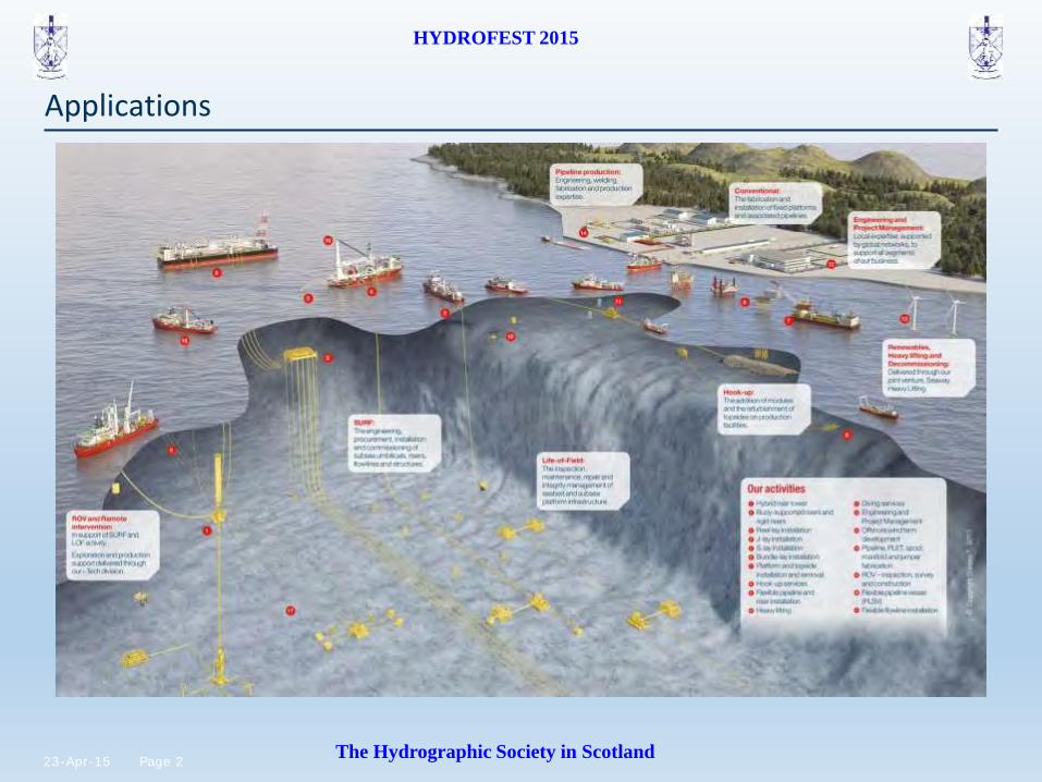
Applications
3 Page 23-Apr-15
HYDROFEST 2015
The Hydrographic Society in Scotland
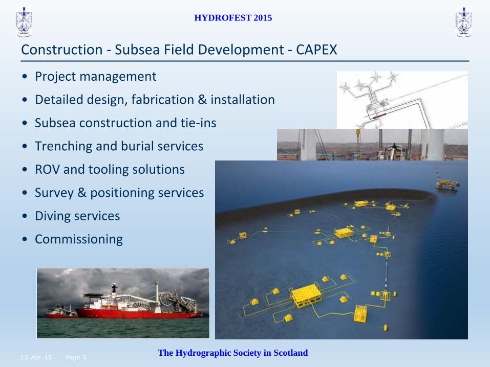
Construction - Subsea Field Development - CAPEX
• Project management
• Detailed design, fabrication & installation
• Subsea construction and tie-ins
• Trenching and burial services
• ROV and tooling solutions
• Survey & positioning services
• Diving services
• Commissioning
4 Page 23-Apr-15
HYDROFEST 2015
The Hydrographic Society in Scotland
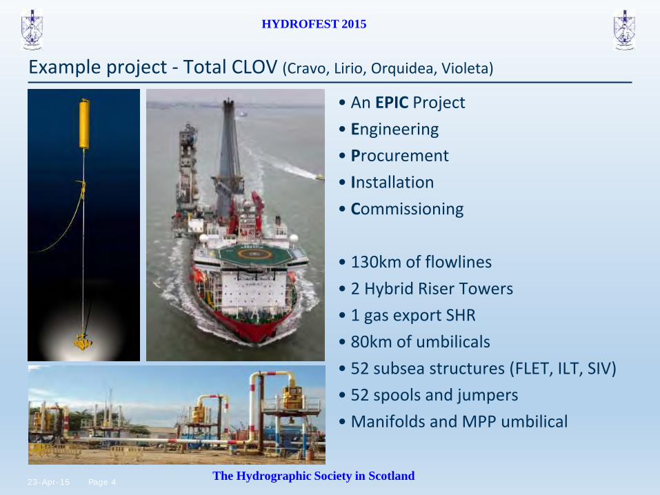
Example project - Total CLOV (Cravo, Lirio, Orquidea, Violeta)
• An EPIC Project
• Engineering
• Procurement
• Installation
• Commissioning
• 130km of flowlines
• 2 Hybrid Riser Towers
• 1 gas export SHR
• 80km of umbilicals
• 52 subsea structures (FLET, ILT, SIV)
• 52 spools and jumpers
• Manifolds and MPP umbilical
5 Page 23-Apr-15
HYDROFEST 2015
The Hydrographic Society in Scotland
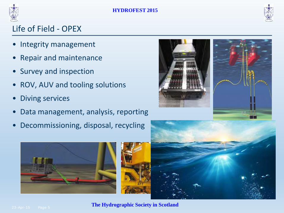
Life of Field - OPEX
• Integrity management
• Repair and maintenance
• Survey and inspection
• ROV, AUV and tooling solutions
• Diving services
• Data management, analysis, reporting
• Decommissioning, disposal, recycling
6 Page 23-Apr-15
HYDROFEST 2015
The Hydrographic Society in Scotland
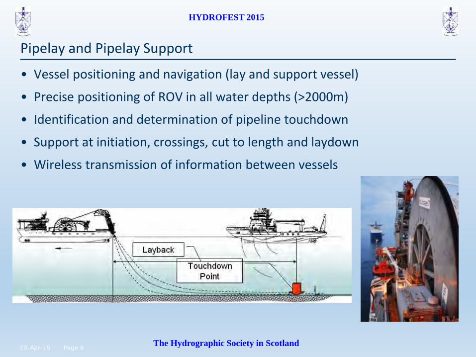
Pipelay and Pipelay Support
• Vessel positioning and navigation (lay and support vessel)
• Precise positioning of ROV in all water depths (>2000m)
• Identification and determination of pipeline touchdown
• Support at initiation, crossings, cut to length and laydown
• Wireless transmission of information between vessels

7 Page 23-Apr-15
HYDROFEST 2015
The Hydrographic Society in Scotland
Bundle Tow and Installation

8 Page 23-Apr-15
HYDROFEST 2015
The Hydrographic Society in Scotland
Bundle monitoring software

9 Page 23-Apr-15
HYDROFEST 2015
The Hydrographic Society in Scotland
Pipeline Surveys
Types of survey:
• Route survey
• Pre-lay
• As-laid / As-built
• General Visual Inspection (GVI)
Typical Focus Areas:
• Lay comfort
• Freespans
• Pipeline damage
• Debris
• Anodes and cathodic protection
• Seabed features and targets
• Pipeline and cable crossings
• Lateral movement

10 Page 23-Apr-15
HYDROFEST 2015
The Hydrographic Society in Scotland
• Upheaval buckling (UHB)
• Precise vertical OOS with INS
• Precise lateral OOS with INS
Out of Straightness Survey (OOS)

11 Page 23-Apr-15
HYDROFEST 2015
The Hydrographic Society in Scotland
Structure Installation Support
• Surface Positioning
• Sub-Surface Positioning
• Depth and altitude monitoring
• Orientation and attitude
• Levelment surveys
• As-installed GVI surveys

12 Page 23-Apr-15
HYDROFEST 2015
The Hydrographic Society in Scotland
Dimensional Control & Metrology
• Onshore
– Dimensional control (total stations, laser, photogrammetry)
• Offshore
– LBL Acoustics
– Subsea laser scanning
– Inertial Navigation
– Photogrammetry
– Taut Wire / Diver

13 Page 23-Apr-15
HYDROFEST 2015
The Hydrographic Society in Scotland
Integrity Management

14 Page 23-Apr-15
HYDROFEST 2015
The Hydrographic Society in Scotland
Platforms for Subsea Sensors
• Vessels
• ROVs
• ROTV/towed sensors
• AIV/AUVs
• Subsea structures
• Surface structures
• Highly dynamic platforms
• All require a number of integrated survey sensors

15 Page 23-Apr-15
HYDROFEST 2015
The Hydrographic Society in Scotland
Subsea Sensors
• What is the first thing we want to find when a platform enters the water?
• Position: e.g. via USBL
• What sensors are needed?
• Acoustic transceiver/transducer
• Acoustic transponder
• Derives horiz + vert angles + range to txp
• What other sensors are needed?
– Heading and motion sensors
• What is to measure and calibrate?
– Offsets
– Heading and motion sensor alignment
– USBL transducer alignment
A long way!

16 Page 23-Apr-15
HYDROFEST 2015
The Hydrographic Society in Scotland
• Subsea positioning has relatively low precision and update rates
• USBL, 2-5 second update rate
• INS aided by USBL and DVL provides:
– Increased precision
– Faster update rates
• Accuracy is still depended on USBL
Subsea Positioning
17 Page 23-Apr-15
HYDROFEST 2015
The Hydrographic Society in Scotland
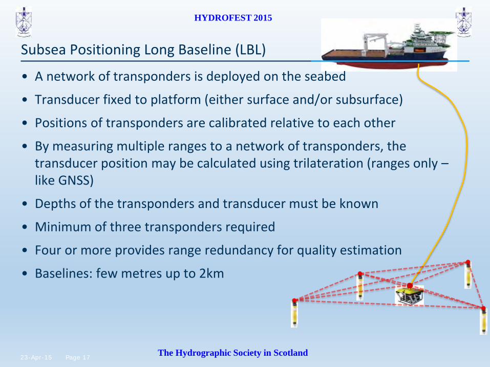
Subsea Positioning Long Baseline (LBL)
• A network of transponders is deployed on the seabed
• Transducer fixed to platform (either surface and/or subsurface)
• Positions of transponders are calibrated relative to each other
• By measuring multiple ranges to a network of transponders, the transducer position may be calculated using trilateration (ranges only – like GNSS)
• Depths of the transponders and transducer must be known
• Minimum of three transponders required
• Four or more provides range redundancy for quality estimation
• Baselines: few metres up to 2km

18 Page 23-Apr-15
HYDROFEST 2015
The Hydrographic Society in Scotland
Positioning systems
Rough guideline depths for use
Surface
500m
1200m
2000m
USBL only
USBL aided INS
USBL aided INS / LBL
LBL
19 Page 23-Apr-15
HYDROFEST 2015
The Hydrographic Society in Scotland
USBL
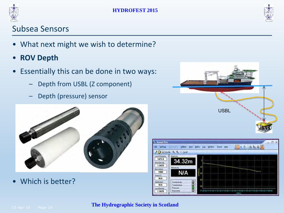
Subsea Sensors
• What next might we wish to determine?
• ROV Depth
• Essentially this can be done in two ways:
– Depth from USBL (Z component)
– Depth (pressure) sensor
• Which is better?

20 Page 23-Apr-15
HYDROFEST 2015
The Hydrographic Society in Scotland
• We now know ROV depth, what next?
• Seabed depth
• (or depth of what is on it)
• Known as bathymetry
• Although most of the time the depth sensor is affectionately known as the “bathy”
• What sensor is needed?
• Echosounder: single, scanning or multibeam
• Normally dual head
Subsea Sensors
Scanning profiler
Multibeam System
Altimeter

21 Page 23-Apr-15
HYDROFEST 2015
The Hydrographic Society in Scotland
ROV based pipeline survey

22 Page 23-Apr-15
HYDROFEST 2015
The Hydrographic Society in Scotland
Multibeam / DHSS pipeline profiling
• How do we survey a pipeline?

23 Page 23-Apr-15
HYDROFEST 2015
The Hydrographic Society in Scotland
Multibeam pipeline profiling courtesy

24 Page 23-Apr-15
HYDROFEST 2015
The Hydrographic Society in Scotland
Sound Velocity Sensors
• SV Probe
– Measures time of flight of an acoustic pulse over a known baseline length
– Very precise; required for MBE and LBL metrology
– Does not provide environmental information
• CTD Probe
– Measures conductivity, temperature and density
– Derives sound velocity using standard formulae
• Chen & Millero WD <1000m
• Del Grosso WD>1000m
25 Page 23-Apr-15
HYDROFEST 2015
The Hydrographic Society in Scotland
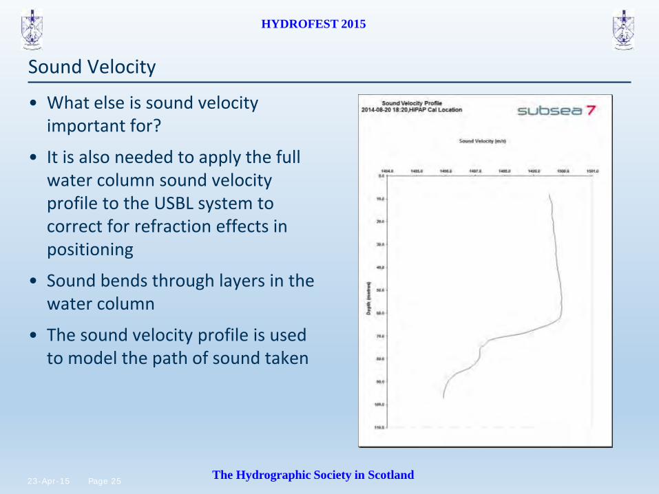
• What else is sound velocity important for?
• It is also needed to apply the full water column sound velocity profile to the USBL system to correct for refraction effects in positioning
• Sound bends through layers in the water column
• The sound velocity profile is used to model the path of sound taken
Sound Velocity

26 Page 23-Apr-15
HYDROFEST 2015
The Hydrographic Society in Scotland
• We can determine ROV position and depth, and even depth of seabed, how do we know where we are going?
• Cameras
• A variety of cameras may be used
• For pipeline survey typically there are three cameras: one centre and two booms
Subsea Sensors

27 Page 23-Apr-15
HYDROFEST 2015
The Hydrographic Society in Scotland
• But what if there is zero visibility?
• Obstacle avoidance sonar (OAS)
• May be mechanical scanning type or beam-forming
Subsea Sensors

28 Page 23-Apr-15
HYDROFEST 2015
The Hydrographic Society in Scotland
ROV Sensors
• What if the product we are trying to survey is buried?
• Pipetracker
• Essentially a big metal detector – 3 coils
• Uses pulse induction techniques to induce a voltage in ferrous targets
• Calculates range to target both vertically and horizontally from centre coil
• Requires knowledge of target size and composition (diameter and material)
• Best results using “target scaling”
• Requires altimeter in order to calculate depth of cover (DOC)

29 Page 23-Apr-15
HYDROFEST 2015
The Hydrographic Society in Scotland
Pipetracker
• Pipetracker
30 Page 23-Apr-15
HYDROFEST 2015
The Hydrographic Society in Scotland
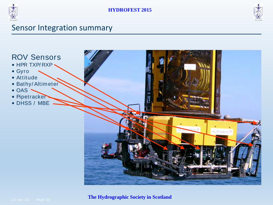
ROV Sensors • HPR TXP/RXP • Gyro • Attitude • Bathy/Altimeter • OAS • Pipetracker • DHSS / MBE
Sensor Integration summary
31 Page 23-Apr-15
HYDROFEST 2015
The Hydrographic Society in Scotland
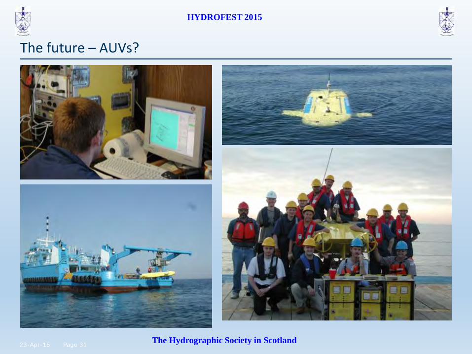
The future – AUVs?
32 Page 23-Apr-15
HYDROFEST 2015
The Hydrographic Society in Scotland
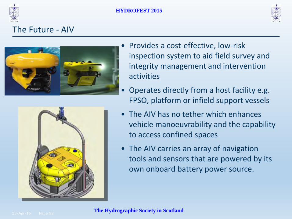
The Future - AIV
• Provides a cost-effective, low-risk inspection system to aid field survey and integrity management and intervention activities
• Operates directly from a host facility e.g. FPSO, platform or infield support vessels
• The AIV has no tether which enhances vehicle manoeuvrability and the capability to access confined spaces
• The AIV carries an array of navigation tools and sensors that are powered by its own onboard battery power source.

33 Page 23-Apr-15
HYDROFEST 2015
The Hydrographic Society in Scotland
HYDROFEST 2015
The Hydrographic Society in Scotland
Subsea Surveys Types of Survey & Application
22/04/2015
Danny Wake
Group Support Surveyor