Hydraulic Simulation of Flood Occurrences in a...
12
Pertanika J. Sci. & Techno!. 10(1): 1-12 (2002) ISSN: 0128-7680 © Universiti Putra Malaysia Press Hydraulic Simulation of Flood Occurrences in a Tropical River System: the Case of Linggi River System Salim Said, Thamer A. Mohammed, Mohd. Zohadie Bardaie, & ShahNor Basri Department of Biological & Agricultural Engineering Faculty of Engineering Universiti Putra Malaysia 43400 UPM, Serdang, Selangor, Malaysia Received: 4 April 2000 ABSTRAK Ramalan banjir adalah penting kerana ianya dapat menolong mengurangkan kerosakan akibat banjir terutamanya di kawasan hilir sungai. Peningkatan dalam kaedah-kaedah numerikal dan teknologi komputer telah menghasilkan banyak model matematik yang boleh digunakan untuk simulasi hidraulik banjir. Simulasi hidraulik banjir dalam satu sistem sungai kebiasaannya termasuk ramalan luas dan kedalaman banjir di sepanjang sungai tersebut. Maklumat sedemikian adalah penting kerana ianya dapat membantu jurutera untuk memberi perhatian yang lebih ke atas reka bentuk bagi mengurangkan kerosakan oleh banjir. Model hidraulik yang digunakan bagi mensimulasikan aliran sungai boleh diklasifikasikan kepada model hidraulik dinamik dan model hidraulik statik. Model HEC-2 statik telah digunakan untuk membuat ramal an hidraulik aliran Sungai Linggi di kawasan Seremban, Malaysia. Model HEC-2 adalah berdasarkan kepada penyelesaian numerikal bagi persamaan tenaga satu dimensi. Kalibrasi dan verifikasi ten tang profil permukaan air telah diperolehi dengan menggunakan data rekod bagi Sungai Linggi. Selepas kalibrasi, model HEC-2 telah digunakan untuk meramalkan profil permukaan air Q 10 dan Q 100 di sepanjang sistem Sungai Linggi. Hasil perbandingan tersebut menunjukkan tiada perbezaan ketara, dengan ralat absolut maksimum adalah 100 mm dan ralat absolut minimum adalah 20 mm sahaja.Bacaan- bacaan ini menunjukkan perbezaan yang kurang daripada 5%. ABSTRACT Flood forecasting is important because it can help in reducing the consequences of flood damage especially at the downstream end. Advances in numerical methods and computer technologies, have resulted in the development of many mathematical models which can be used for hydraulic simulation of flood. These simulations usually include the prediction of the extent of flood and its depth along a river system. Information obtained from the simulated models are essential because it can help engineers to take precautionary measures in designing their hydraulic structures. Hydraulic models that are used in the simulation can be classified into dynamic hydraulic models and static hydraulic models. The HEC-2 static hydraulic model was used to predict the flow of Linggi river in the vicinity of Seremban town. HEC-2 model is based on the numerical solution of a one-dimensional energy equation of the steady gradually varied flow using an iteration technique. Calibration and verification of the HEC-2 model were conducted using the recorded data for the Linggi
Transcript of Hydraulic Simulation of Flood Occurrences in a...
Pertanika J. Sci. & Techno!. 10(1): 1-12 (2002)ISSN: 0128-7680
© Universiti Putra Malaysia Press
Hydraulic Simulation of Flood Occurrences in a Tropical RiverSystem: the Case of Linggi River System
Salim Said, Thamer A. Mohammed, Mohd. Zohadie Bardaie,& ShahNor Basri
Department of Biological & Agricultural EngineeringFaculty of Engineering
Universiti Putra Malaysia43400 UPM, Serdang, Selangor, Malaysia
Received: 4 April 2000
ABSTRAKRamalan banjir adalah penting kerana ianya dapat menolong mengurangkankerosakan akibat banjir terutamanya di kawasan hilir sungai. Peningkatandalam kaedah-kaedah numerikal dan teknologi komputer telah menghasilkanbanyak model matematik yang boleh digunakan untuk simulasi hidraulikbanjir. Simulasi hidraulik banjir dalam satu sistem sungai kebiasaannya termasukramalan luas dan kedalaman banjir di sepanjang sungai tersebut. Maklumatsedemikian adalah penting kerana ianya dapat membantu jurutera untukmemberi perhatian yang lebih ke atas reka bentuk bagi mengurangkan kerosakanoleh banjir. Model hidraulik yang digunakan bagi mensimulasikan aliransungai boleh diklasifikasikan kepada model hidraulik dinamik dan modelhidraulik statik. Model HEC-2 statik telah digunakan untuk membuat ramalanhidraulik aliran Sungai Linggi di kawasan Seremban, Malaysia. Model HEC-2adalah berdasarkan kepada penyelesaian numerikal bagi persamaan tenagasatu dimensi. Kalibrasi dan verifikasi ten tang profil permukaan air telahdiperolehi dengan menggunakan data rekod bagi Sungai Linggi. Selepaskalibrasi, model HEC-2 telah digunakan untuk meramalkan profil permukaanair untuk~,Q
10dan Q
100di sepanjang sistem Sungai Linggi. Hasil perbandingan
tersebut menunjukkan tiada perbezaan ketara, dengan ralat absolut maksimumadalah 100 mm dan ralat absolut minimum adalah 20 mm sahaja.Bacaanbacaan ini menunjukkan perbezaan yang kurang daripada 5%.
ABSTRACTFlood forecasting is important because it can help in reducing the consequencesof flood damage especially at the downstream end. Advances in numericalmethods and computer technologies, have resulted in the development ofmany mathematical models which can be used for hydraulic simulation offlood. These simulations usually include the prediction of the extent of floodand its depth along a river system. Information obtained from the simulatedmodels are essential because it can help engineers to take precautionarymeasures in designing their hydraulic structures. Hydraulic models that areused in the simulation can be classified into dynamic hydraulic models andstatic hydraulic models. The HEC-2 static hydraulic model was used to predictthe flow of Linggi river in the vicinity of Seremban town. HEC-2 model is basedon the numerical solution of a one-dimensional energy equation of the steadygradually varied flow using an iteration technique. Calibration and verificationof the HEC-2 model were conducted using the recorded data for the Linggi
Salim Said, Thamer A. Mohammed, Mohd. Zohadie Bardaie & Shah or Basri
river. After calibration, the model was used to predict the water surface profilesfor ~, Q10' and Q100 along the watercourse of the Linggi river. The predictedwater surface profiles were found to be in agreement with the recorded watersurface profiles, whereby the maximum computed value of the absolute errorin the predicted water surface profile was found to be 100 mm while theminimum absolute error was found to be 20 mm only. In term of percentage,these errors represent a difference of less than 5% between the readings of thecomputed simulation to the actual field records. Testing process showed thatHEG-2 model is sensitive to value of Manning coefficient of roughness and theintervals of cross sections long studied river system.
Keywords: Simulation, modelling, flood, tropical river system, water surfaceprofile
INTRODUCTION
A flood is any abnormally high water-stage or flow over land, in a stream,floodway, lake, or coastal areas that can cause detrimental effects to life andproperty. Flooding in the river system of a tropical region is mainly due toexcessive rainfall in the upper catchment of the river system. This is made worseif the catchment area is infringed with development. The worst flood inMalaysia was recorded in 1926 which had been described as having caused themost extensive damage to the natural environment. Subsequent major floodswere recorded in 1931, 1947, 1954, 1957, 1967, and 1971. Floods of lessermagnitude also occurred in 1973, 1979 and 1983 (Ann 1994). As a result ofadvances in numerical methods and computer technologies, many mathematicalmodels have been developed and used for hydraulic simulation of the flood.The hydraulic simulation of the flood in a river system usually includes theprediction of the extent of flood and its depth along a river course. This typeof information is essential because it will help engineers to take precautionarymeasures in their design so as to minimize the potential flood damage especiallyat the downstream end. Hydraulic models that are used in the simulation canbe classified into dynamic hydraulic models and static hydraulic models. Thisclassification was based on the concept and the approach used in the formulationof these models. An example of a recent work on the static hydraulic model forcomputing water surface profile in prismatic and non-prismatic channels wasdeveloped by Ishikawa (1984). Examples of dynamic hydraulic models werethose developed by Lyness and Myers (1994), Molls and Chaudhary (1995), andSturm and Sadiq (1996). Nik (1996) applied both HEC-2 static hydraulic modeland MIKE 11 dynamic hydraulic model to predict the water surface elevationof the Klang River, and found that there was a difference of about 5% in theresults obtained. In the present study, the HEC-2 static hydraulic model wascalibrated, verified and then applied to predict the water surface profiles alongthe watercourse of the Linggi river and its tributaries.
2 PertanikaJ. Sci. & Techno!. Vol. 10 o. 1,2002
Hydraulic Simulation of Flood Occurrences in a Tropical River System
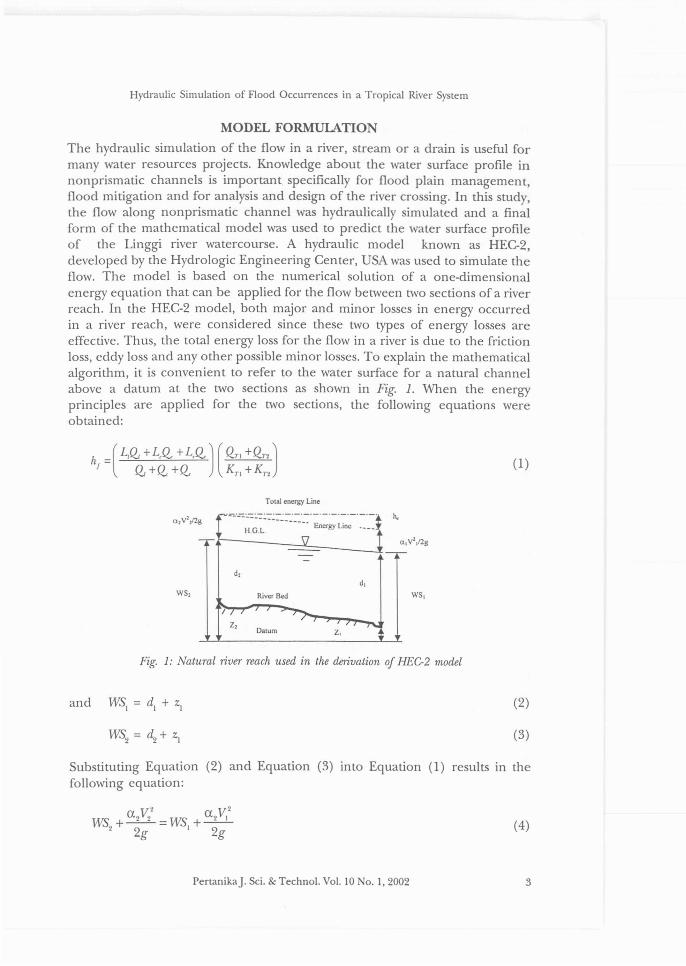
MODEL FORMULATIONThe hydraulic simulation of the flow in a river, stream or a drain is useful formany water resources projects. Knowledge about the water surface profile innonprismatic channels is important specifically for flood plain management,flood mitigation and for analysis and design of the river crossing. In this study,the flow along nonprismatic channel was hydraulically simulated and a finalform of the mathematical model was used to predict the water surface profileof the Linggi river watercourse. A hydraulic model known as HEC-2,developed by the Hydrologic Engineering Center, USA was used to simulate theflow. The model is based on the numerical solution of a one-dimensionalenergy equation that can be applied for the flow between two sections of a riverreach. In the HEC-2 model, both major and minor losses in energy occurredin a river reach, were considered since these two types of energy losses areeffective. Thus, the total energy loss for the flow in a river is due to the frictionloss, eddy loss and any other possible minor losses. To explain the mathematicalalgorithm, it is convenient to refer to the water surface for a natural channelabove a datum at the two sections as shown in Fig. 1. When the energyprinciples are applied for the two sections, the following equations wereobtained:
(1)
Tolal energy Line
a,V',ng ~='~~-=~~:~~::-~=-::"-~'~~:~~:~-'~'_~l h.
r- \l aly11ng
d,d,
ws, River Bed WS,
/71 ;;>
z,,
z, '7-,...,;Datum
Fig. 1: Natural river reach used in the derivation of HEC-2 model
(2)
(3)
Substituting Equation (2) and Equation (3) into Equation (1) results in thefollowing equation:
a V 2 a V 2
WS +_2_2_=WS +_2_12 2g 1 2g
PertanikaJ. Sci. & Technol. Vol. 10 No. 1,2002
(4)
3
Salim Said, Thamer A. Mohammed, Mohd. Zohadie Bardaie & Shah or Basri
Where WSI, WS
2are water surface elevations from a datum for section 1 and
section 2 respectively, d l , d2 are water depths at section 1 and section 2respectively, ZI ' ~ are the channel bed elevations above a datum at section 1and section 2 respectively, ~ , ~ are average velocities (total discharge per totalarea of the flow) at section 1 and section 2 respectively, ai' a
2are velocity
weighting coefficients at section 1 and section 2 respectively, g is the accelerationdue to gravity, and he is the energy loss in the reach.
Chow (1959) defined the energy loss in the reach ofa river as a combinationof the friction loss and eddy loss:
(5)
where hj
is the friction loss and hi is the eddy loss.
The eddy loss hi is appreciable in nonprismatic channels and there is noavailable rational method of evaluating this loss. The eddy loss depends mainlyon the velocity head change and may be expressed as shown below:
(
V2 V2
)h =8 a _2__ a -'I 22g 12g
where 8 is the eddy loss coefficient.
(6)
For a gradual1y converging reach, 8 varies from 0 to 0.1, and for a gradual1ydiverging reach 8 varies from 0 to 0.2. For abrupt expansions and contractions,8 is about 0.5. For prismatic and regular channels, the eddy loss is practical1yzero, (8 = 0). For nonprismatic channel, friction loss can be described by thefol1owing formula:
(7)
The discharge-weighted reach length L in Equation (7) is computed byproper proportioning the length of left overbank, the main channel, and rightoverbank with their respective flows at the end of the reach as given by thefol1owing equation :
L=L,~ + L/I, +L,Q,~ +(2. +Q,
A representative friction slope S is expressed as fol1ows:
(8)
4 PertanikaJ. Sci. & Techno!. Vo!. 10 No. 1,2002
Hydraulic Simulation of Flood Occurrences in a Tropical River System
where Lr Lc' L, are reach lengths specified for flow in left over bank, mainchannel and right overbank, respectively, Qp Q" Q. are arithmetic average of theflows at the ends of the reach for left overbank, main channel, and rightoverbank respectively, QIl' Q72 are the values of the total discharge at section1 and 2 respectively, KJV KJ2 are the composite or total conveyance for section1 and 2 respectively.
By substituting Equation (8) and Equation (9) into Equation (7), thefollowing equation is obtained:
(10)
Total energy loss in a river reach he can be obtained by substituting Equation(10) and Equation (6) into Equation (5):
h == (L,Q, + L,Q. +L,Q.) ( QT1 +QT2 ) 2 + j ex 2V22
_ ex IV,2)f Q, +(2" +Q. Kn +Kr2 '\ 2g 2g
The total conveyance of a river section can be described as below:
(11)
(i == 1, 2, 3, ... , N) (12)
If the river section is divided into N number of subsections, the total conveyanceis the sum of the conveyance for each subsection as shown below:
(13)
where kl' 's, h3
, ••• , kN are the conveyance for the subsection number 1, 2, 3,
To simplify the calculation, natural channel is divided into three mainsubsections namely the right bank, the central reach and the left bank as shownin Fig. 2.
Equation (13) can be simplified into the following form:
(14)
where hi' he and h, are the conveyance of the left subsection, central channel,and right subsection respectively.
From the Manning formula, the conveyance of each subsection can bewritten as:
1 2/3h==-AR} nj } } U== I, c, r)
PertanikaJ. Sci. & Techno!. Vo!. 10 TO. 1,2002
(15)
5

Salim Said, Thamer A. Mohammed, Mohd. Zohadie Bardaie & ShahNor Basri
where I, c, and r denote the left subsection, central subsection and rightsubsection
Fig. 2: Division oj the ]looded natural cross section into discrete elements
By substituting Equation (15) into Equation (14), the following equation IS
obtained:
where n p nc' and n r is Manning coefficient of roughness for left overbank,central channel, and right overbank respectively.
The velocity coefficient a at any river section can be written as:
a V 2 U 2V,2WS +_2_2 =WS +-- (17)
2 2g I 2g
where ~ is the total area of cross section, AI, Ac, Ar are flow area of leftoverbank, main channel and right overbank, respectively.
In Equation (17), the difference in velocity head between the main channeland the overbank sections is taken into consideration. The average velocity ata section can be described by:
(18)
By substituting Equation (18), Equation (17) and Equation (11) into Equation(4) and after simplifying, the following equation is obtained:
6 PertanikaJ. Sci. & Techno!. Vol. 10 No. 1,2002
Hydraulic Simulation of Flood Occurrences in a Tropical River System
COMPUTATIONAL METHOD
Equation (19) describes the HEC-2 model that can be used to predict the watersurface profile of a river for known values of discharge and the Manningcoefficient of roughness. On the other hand the section geometry along theriver must be defined in the model computation. umerical computation ofEquation (19) can be performed manually, but it is rather cumbersome andtime consuming. The HEC-2 program has been developed to perform thenumerical computation of Equation (19). The numerical implementation ofEquation (19) can be explained as follows:1. Assume a water surface elevation at the upstream cross section WS2 for
subcritical flow in the river channel while the SW1
is known.2. Based on the assumed water surface elevation, determine the corresponding
total conveyance. The determinations of the areas and the conveyance forsubsections are important for model application.
3. Solve Equation (19) for SW2
and compare the computed value of SW2
withthe value assumed in step 1; repeat steps 1 to 3 until the value agree withinO.Olm accuracy. The calculated SW2 will be used as SW
1for the computation
of the water surface elevation to the next upstream section.
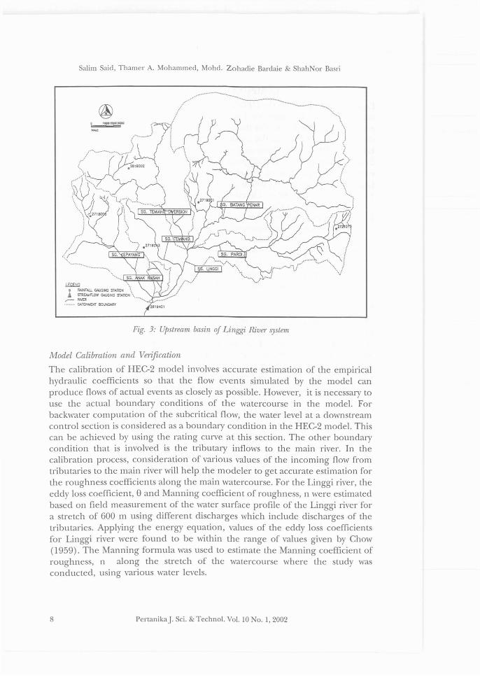
Linggi River
The Linggi river is a major river system 10 the state of egeri Sembilan,Malaysia. The river discharges its water to the sea (The Straits of Malacca)through the river mouth at Port Dickson, which is located approximately 53 kmdownstream from Seremban town, the capital of the state. Seremban is locatedapproximately 70 km south of Kuala Lumpur at Latitude 2.750 orth andLongitude 101.90 East. Simulation of water surface profile of the Linggi riverwas carried out for the river system in the vicinity of the Seremban town. Fig.3 shows the upstream Linggi River basin and the Seremban town occupies thelower portion of the basin. The Linggi river system passes through residential,commercial, industrial and agricultural areas. There are several areas within thetownship that experience flooding due to the high flows of the Linggi riverduring the rainy season. It is important to control flooding in the town centreby increasing the carrying capacity of the linggi river. According to a surveydata, the average slope of the Linggi river is 1/500 while the measured lengthup to the control point (Station 2619401) is 5688 m (Mohammed 1998).
Data Acquisition
The data needed for this study was obtained from the Hydrology Section of theDrainage and Irrigation Department (DID) in Kuala Lumpur. The data acquiredcan be categorized as: (a) the streamflow records, (b) the stage records, (c) thelongitudinal section of the river and (d) the cross sections of the river at 50 minterval.
PertanikaJ. Sci. & Techno!. Vol. 10 o. 1,2002 7
Salim Said, Thamer A. Mohammed, Mohd. Zohadie Bardaie & ShahNor Basri
....................
.......................................... .
......1' .: ~ '
. .
Fig. 3: Upstream basin oj Linggi River s),stem
Model Calibration and Verification
The calibration of HEC-2 model involves accurate estimation of the empiricalhydraulic coefficients so that the flow events simulated by the model canproduce flows of actual events as closely as possible. However, it is necessary touse the actual boundary conditions of the watercourse in the model. Forbackwater computation of the subcritical flow, the water level at a downstreamcontrol section is considered as a boundary condition in the HEC-2 model. Thiscan be achieved by using the rating curve at this section. The other boundarycondition that is involved is the tributary inflows to the main river. In thecalibration process, consideration of various values of the incoming flow fromtributaries to the main river will help the modeler to get accurate estimation forthe roughness coefficients along the main watercourse. For the Linggi river, theeddy loss coefficient, 8 and Manning coefficient of roughness, n were estimatedbased on field measurement of the water surface profile of the Linggi river fora stretch of 600 m using different discharges which include discharges of thetributaries. Applying the energy equation, values of the eddy loss coefficientsfor Linggi river were found to be within the range of values given by Chow(1959). The Manning formula was used to estimate the Manning coefficient ofroughness, n along the stretch of the watercourse where the study wasconducted, using various water levels.
8 PertanikaJ. Sci. & Techno!. Vo!. 10 0.1,2002

Hydraulic Simulation of Flood Occurrences in a Tropical River System
To study the effect of the variation in values of Manning coefficient ofroughness, the n values were varied from 0.03 to 0.032 for the central channelonly. For the left and right banks which are grown with grass, the value of theManning roughness coefficient were varied from 0.032 to 0.04 depending onthe conditions of the banks. Field measurement for water surface profile for theLinggi river was used in the verification process of HEC-2 model. Using anactual flow of 36.2 m3/s and a value of the Manning coefficient of roughnessequal to 0.032, the HEC-2 model was used to predict the water surface profilefor the 600 m stretch of the Linggi river. The simulated water surface profilewas then compared to the actual measured water surface profile as shown inFig. 4. The maximum and minimum absolute errors in the predicted watersurface profile for Linggi river were computed and found to be 100 mm and20 mm respectively (Mohammed 1998). The deviations were less than 5%.
SENSITIVITY ANALYSIS
Accuracy of the computed water surface profiles for a river using HEC-2 modelis dependent on many factors such as the accuracy of the stream geometry,accurate estimation of the Manning coefficient of roughness and intervalbetween stations along a river. It is premised that modern survey technologiescan give good accuracy in determining cross-sectional geometry of the river, sothe sensitivity analysis was limited to the impact of Manning coefficient ofroughness and the intervals between the cross sections or stations on theaccuracy of the predicted water surface profile for Linggi river using HEC-2model. Using constant interval of 50 m between stations along the Linggi river,
-o-Model30.6
--Recorded
30.4E';;' 30.2 Q=36.2 mlls0.~
30 n=0.032;>...i:i:l8 29.8
~29.6;:3
Vl
29.2
700600500400300200100
29 -t---,,----,---,----,--..........-----r--..,a
Distance (m)
Fig. 4: Verification of the HEC-2 model using recorded water surfaceelevation of the Linggi river
PertanikaJ. Sci. & Techno!. Vo!. 10 o. 1,2002 9
Salim Said, Thamer A. Mohammed, Mohd. Zohadie Bardaie & ShahNor Basri
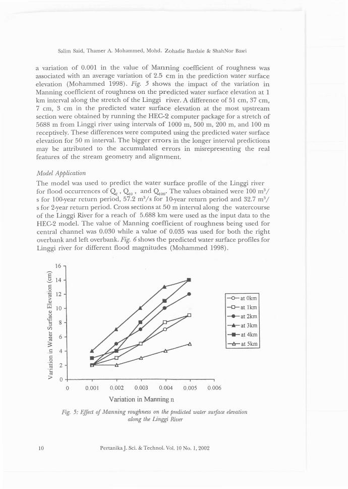
a variation of 0.001 in the value of Manning coefficient of roughness wasassociated with an average variation of 2.5 cm in the prediction water surfaceelevation (Mohammed 1998). Fig. 5 shows the impact of the variation inManning coefficient of roughness on the predicted water surface elevation at 1km interval along the stretch of the Linggi river. A difference of 51 cm, 37 cm,7 cm, 3 cm in the predicted water surface elevation at the most upstreamsection were obtained by running the HEC-2 computer package for a stretch of5688 m from Linggi river using intervals of 1000 m, 500 m, 200 m, and 100 mreceptively. These differences were computed using the predicted water surfaceelevation for 50 m interval. The bigger errors in the longer interval predictionsmay be attributed to the accumulated errors in misrepresenting the realfeatures of the stream geometry and alignment.
Model Application
The model was used to predict the water surface profile of the Linggi riverfor flood occurrences of~, QlO' and QIOO' The values obtained were 100 m3/
s for 100-year return period, 57.2 m3/s for 10-year return period and 32.7 m3/
s for 2-year return period. Cross sections at 50 m interval along the watercourseof the Linggi River for a reach of 5.688 km were used as the input data to theHEC-2 model. The value of Manning coefficient of roughness being used forcentral channel was 0.030 while a value of 0.035 was used for both the rightoverbank and left overbank. Fig. 6 shows the predicted water surface profiles forLinggi river for different flood magnitudes (Mohammed 1998).
16
8'(.) 14.......,c:0.~ 12>euW 10eu
(.)
] 8rJ)...eu 6~
~.S 4c:0.~ 2.~
;> 0
0 0.001 0.002 0.003 0.004 0.005 0.006
--<r-at Okm
-D-at lkm
-+-at 2km
--.II- at 3km
-e-at4km
-ir-at skm
10
Variation in Manning n
Fig. 5: Effect oj Manning roughness on the predicted water surface elevationalong the Linggi River
PertanikaJ. Sci. & Techno!. Vo!. 10 No.1, 2002

Hydraulic Simulation of Flood Occurrences in a Tropical River System
-'-Tr=lOO Yrs
---Tr=lO Yrs
--*-Tr=2 Yrs
43
42
:§: 41c0 40.z:::
'"> 39"[jj" 38u
~ 37C/J.... 36"til~ 35
34
0 2 3 4 5 6
Distance (km)
Fig. 6: Predicted water surface elevation Jor the Linggi. River
CONCLUSION
The application of the HEC-2 model to the Linggi river system in the vicinityof Seremban, showed a good agreement between the predicted water surfaceprofile and the recorded water surface profile. The maximum absolute error inthe predicted water surface profile for Linggi river was found to be 100 mmwhile the minimum absolute error was only 20 mm only. These errors are lessthan 5% of the recorded data). Model testing showed that HEC-2 is sensitiveto value of Manning coefficient of roughness and the intervals of cross sectionslong the studied river system. Tacking into consideration model sensitivity,HEC-2 model can be applied to simulate the water surface profile of a tropicalriver system with reasonable accuracy.
REFERENCES
ANN, O.C. 1994. A Review of Irrigation, Drainage and Flood Control Projects inMalaysia. Proceedings oj National ConJerence on Environmental Impact Assessment JorIrrigation Drainage and Flood Control, pp. 1-14. Malaysia: Kuala Terengganu.
CHOW, V.T. 1959. Open Channel Hydraulics. McGraw-Hill Company.
HmROLOGIC ENGINEERING CENTER. 1991. HEC-2 Water Surface Profiles: User's Manual U.S.Army Corps oj Engineers, U.S.A Davis: California.
ISHIKAWA, T. 1984. Water surface profile of stream with side overflow. Joumal oj HydraulicEngineering ASCE 110(12): 1830-1840.
LYNESS, J.F. and W.R. MYERS. 1994. Velocity Coefficients for Overbank in a CompactCompound Channel and Their Effect on the Use of One Dimensional Flow Models2nd International ConJerence on Hydraulic Modelling, Stanford upon Avon, U.K
MOHAMMED, THAMER AHMED. 1998. Flood simulation models for a river system in a tropicalregion: the case of Linggi River Malaysia. A Ph.D Thesis, Faculty of Engineering,Universiti Putra Malaysia.
PertanikaJ. Sci. & Techno!. Vo!. 10 No.1, 2002 II

Salim Said, Thamer A. Mohammed, Mohd. Zohadie Bardaie & Shah or Basri
MOLLS, T. and M. H. CHAUDHRY. 1995. Depth-averaged open-channel flow model. Journalof Hydmulic Engineering ASCE 121(6): 453-465.
NIK, A. 1996. Klang River improvement works. Report Submitted to the Department ofIrrigation and Drainage. Malaysia: Kuala Lumpur.
STURM, T. W. and A. SADlQ. 1996. Water surface profiles in compound channel withmultiple critical depths. Journal of Hydraulic Engineering ASCE 122(12): 703-708.
12 PertanikaJ. Sci. & Techno!. Vol. 10 No. 1,2002