hurricanes - geo.hunter.cuny.edufbuon/PGEOG_130/Lecture... · Hurricanes formation requires...
26
HURRICANES Most information taken from the Tropical Prediction Center (National Hurricane Center) http://www.nhc.noaa.gov/ http://hpccsun.unl.edu/nebraska /stuproj/amets00/hauptmann/sp acegallery.html
-
Upload
nguyenkhuong -
Category
Documents
-
view
219 -
download
0
Transcript of hurricanes - geo.hunter.cuny.edufbuon/PGEOG_130/Lecture... · Hurricanes formation requires...

HURRICANESMost information taken from the Tropical Prediction Center (National Hurricane Center)http://www.nhc.noaa.gov/
http://hpccsun.unl.edu/nebraska/stuproj/amets00/hauptmann/spacegallery.html

The official hurricane season for the Atlantic Basin (the Atlantic Ocean, the Caribbean Sea, and the Gulf of Mexico) is from 1 June to 30 November.


Hurricanes formation requires Coriolis force.
Western Pacific Ocean = typhoons or cyclones

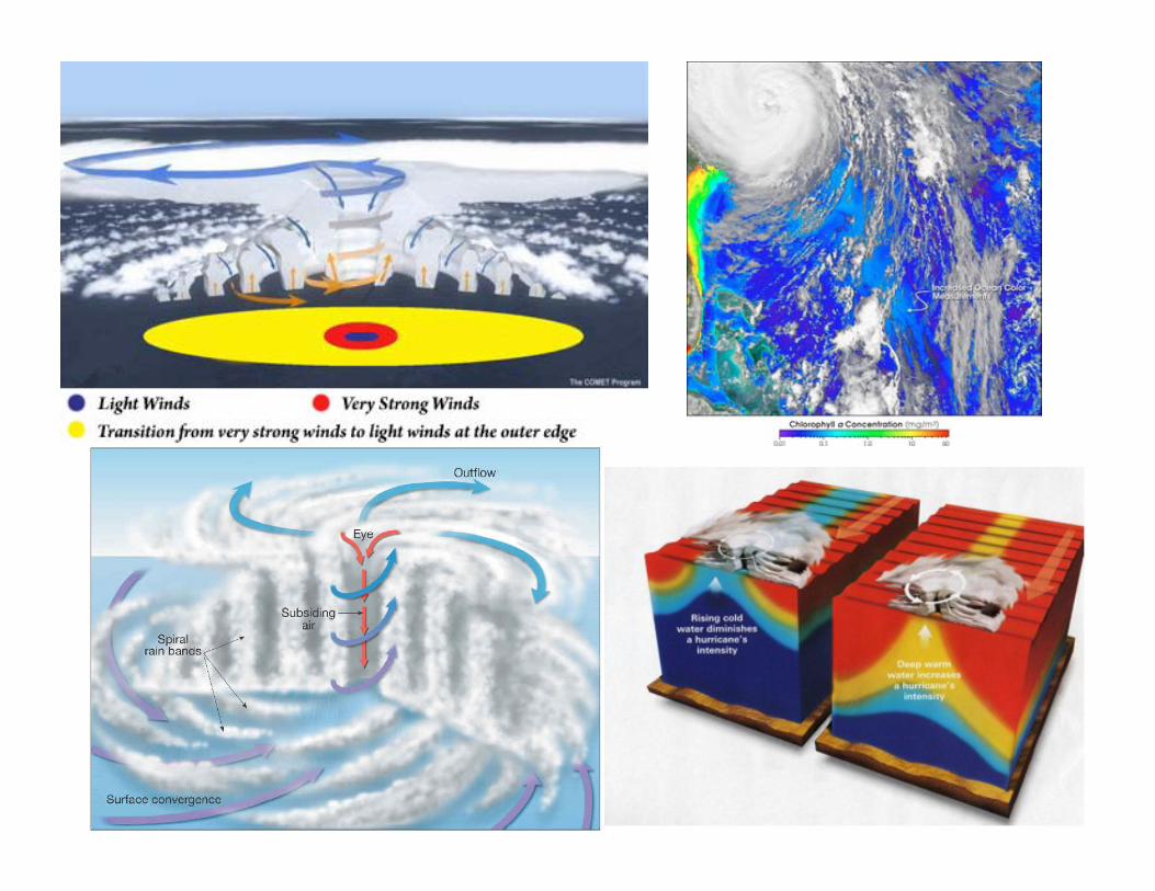
Step 1Tropical Wave: "bump" or disruption of normal tropical easterly flow. Associated turning of wind causes low-level convergence of air; which helps with falling pressure and enhanced showers.
Step 2This can evolve into a Tropical Depression, which is a closed circulation of air in the low levels. This in turn increases convergence and pressure falls, and wind speeds increase in a Catch-22 effect (i.e. the stronger the wind blows the greater the convergence, the quicker the pressure falls... so the stronger the wind, etc.).
Hurricane Development(from www.accuweather.com)

Step 3Once sustained winds reach 39 mph in the closed circulation a Tropical Storm is named. Usually there are at least 2 closed isobars of 4 mb increments around the center. If atmospheric conditions remain correct the system will evolve into a...
Step 4Hurricane. There is usually a difference in pressure of at least 0.60 inches of mercury between the center and surrounding pressure field, with the greatest change near the center (eyewall). It is this great difference in pressure, which sometimes can be as great as 2.95 inches of mercury, that causes the wind to be so strong.

Step 5A mature hurricane is a well-oiled meteorological machine, but disruption of the processes that drive the storm (i.e. interaction with land, colder air feeding in, or cold water) will begin to destroy the storm, and the disintegration of a hurricane can often be quick and dramatic.
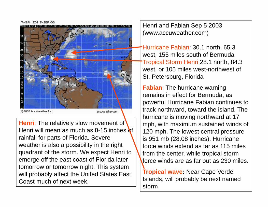
Henri and Fabian Sep 5 2003 (www.accuweather.com)
Hurricane Fabian: 30.1 north, 65.3 west, 155 miles south of Bermuda Tropical Storm Henri 28.1 north, 84.3 west, or 105 miles west-northwest of St. Petersburg, Florida
Fabian: The hurricane warning remains in effect for Bermuda, as powerful Hurricane Fabian continues to track northward, toward the island. The hurricane is moving northward at 17 mph, with maximum sustained winds of 120 mph. The lowest central pressure is 951 mb (28.08 inches). Hurricane force winds extend as far as 115 miles from the center, while tropical storm force winds are as far out as 230 miles.
Tropical wave: Near Cape Verde Islands, will probably be next named storm
Henri: The relatively slow movement of Henri will mean as much as 8-15 inches of rainfall for parts of Florida. Severe weather is also a possibility in the right quadrant of the storm. We expect Henri to emerge off the east coast of Florida later tomorrow or tomorrow night. This system will probably affect the United States East Coast much of next week.
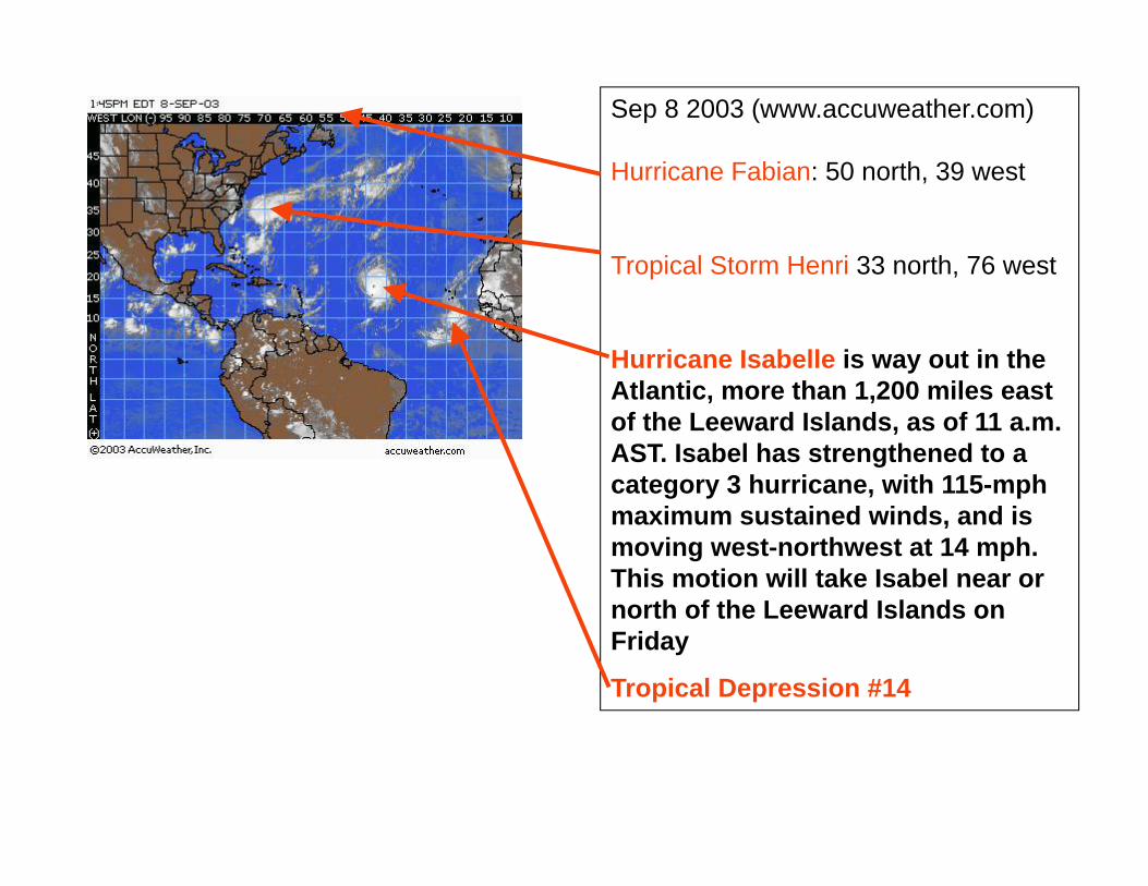
Sep 8 2003 (www.accuweather.com)
Hurricane Fabian: 50 north, 39 west
Tropical Storm Henri 33 north, 76 west
Hurricane Isabelle is way out in the Atlantic, more than 1,200 miles east of the Leeward Islands, as of 11 a.m. AST. Isabel has strengthened to a category 3 hurricane, with 115-mph maximum sustained winds, and is moving west-northwest at 14 mph. This motion will take Isabel near or north of the Leeward Islands on Friday
Tropical Depression #14

http://weather.unisys.com

Tropical StormWinds 39-73 mph
Category 1 Hurricane — winds 74-95 mph (64-82 kt)No real damage to buildings. Damage to unanchored mobile homes. Some damage to poorly constructed signs. Also, some coastal flooding and minor pier damage.
Category 2 Hurricane — winds 96-110 mph (83-95 kt)Some damage to building roofs, doors and windows. Considerable damage to mobile homes. Flooding damages piers and small craft in unprotected moorings may break their moorings. Some trees blown down.
http://ww2010.atmos.uiuc.edu/(Gh)/guides/mtr/hurr/awar.rxml

Category 3 Hurricane — winds 111-130 mph (96-113 kt)Some structural damage to small residences and utility buildings. Large trees blown down. Mobile homes and poorly built signs destroyed. Flooding near the coast destroys smaller structures with larger structures damaged by floating debris. Terrain may be flooded well inland.
Category 4 Hurricane — winds 131-155 mph (114-135 kt)More extensive curtainwall failures with some complete roof structure failure on small residences. Major erosion of beach areas. Terrain may be flooded well inland.
Category 5 Hurricane — winds 156 mph and up (135+ kt)Complete roof failure on many residences and industrial buildings. Some complete building failures with small utility buildings blown over or away. Flooding causes major damage to lower floors of all structures near the shoreline. Massive evacuation of residential areas may be required.

46 35.20 -73.10 09/21/12Z 100 938 HURRICANE-3 47 39.00 -73.00 09/21/18Z 85 940 EXTRATROPICAL STORM-1 48 43.40 -73.10 09/22/00Z 70 967 EXTRATROPICAL STORM-1
http://weather.unisys.com
Great New England Hurricane, 10-22 Sep. 1938, (cat. 5)

Reported Impacts
Formation of new inlets
Overwash and destruction of sand dunes
-18 ft above msl
NY District, USACE
Observed Storm Surge (ft)
Montauk Point 14.7
Westhampton 11.9
Rockaway 9.7War DepartmentBeach Erosion Board, 8/6/46
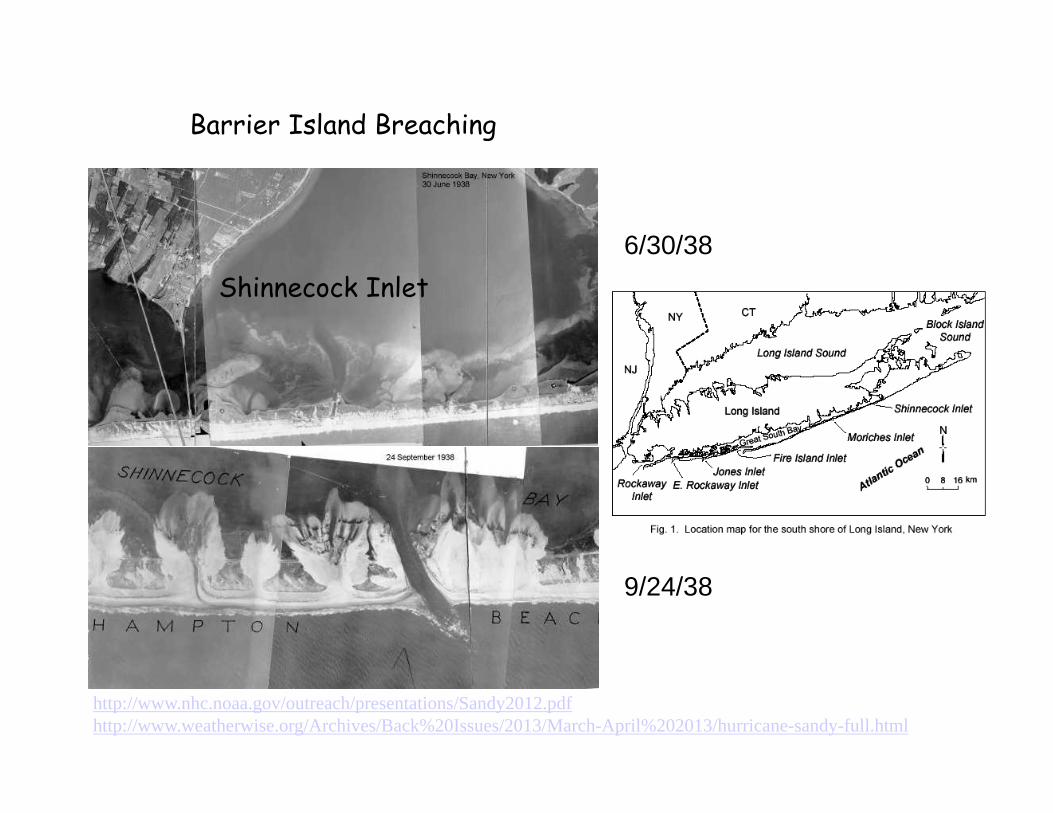
Barrier Island Breaching
Shinnecock Inlet6/30/38
9/24/38
http://www.nhc.noaa.gov/outreach/presentations/Sandy2012.pdfhttp://www.weatherwise.org/Archives/Back%20Issues/2013/March-April%202013/hurricane-sandy-full.html

DANGERS FROM HURRICANES
-1- STORM SURGE
-2- MARINE SAFETY-3- HIGH WINDS-4- TORNADOES-5- INLAND FLOODING

http://newyorkmetro.com/nymetro/news/features/15002/
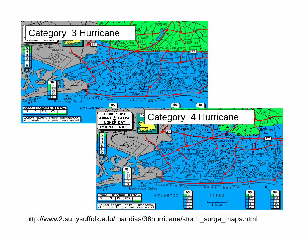
Category 3 Hurricane
Category 4 Hurricane
http://www2.sunysuffolk.edu/mandias/38hurricane/storm_surge_maps.html

http://www2.sunysuffolk.edu/mandias/38hurricane/storm_surge_maps.html
Category 3 Hurricane
Category 4 Hurricane

Category 2 Hurricane
Category 3 Hurricane
http://www2.sunysuffolk.edu/mandias/38hurricane/storm_surge_maps.html

Worst Case Scenario

Worst Case Scenario

Vortex-following (double nest) MM5 Run
Courtesy of the Shuyi Chen at U Miami

Floyd animation of 4-km moveable nest