Hurricane Odile · Odile made landfall on the southern tip of the Baja California peninsula as a...
26
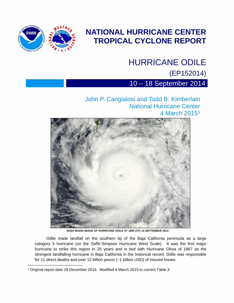
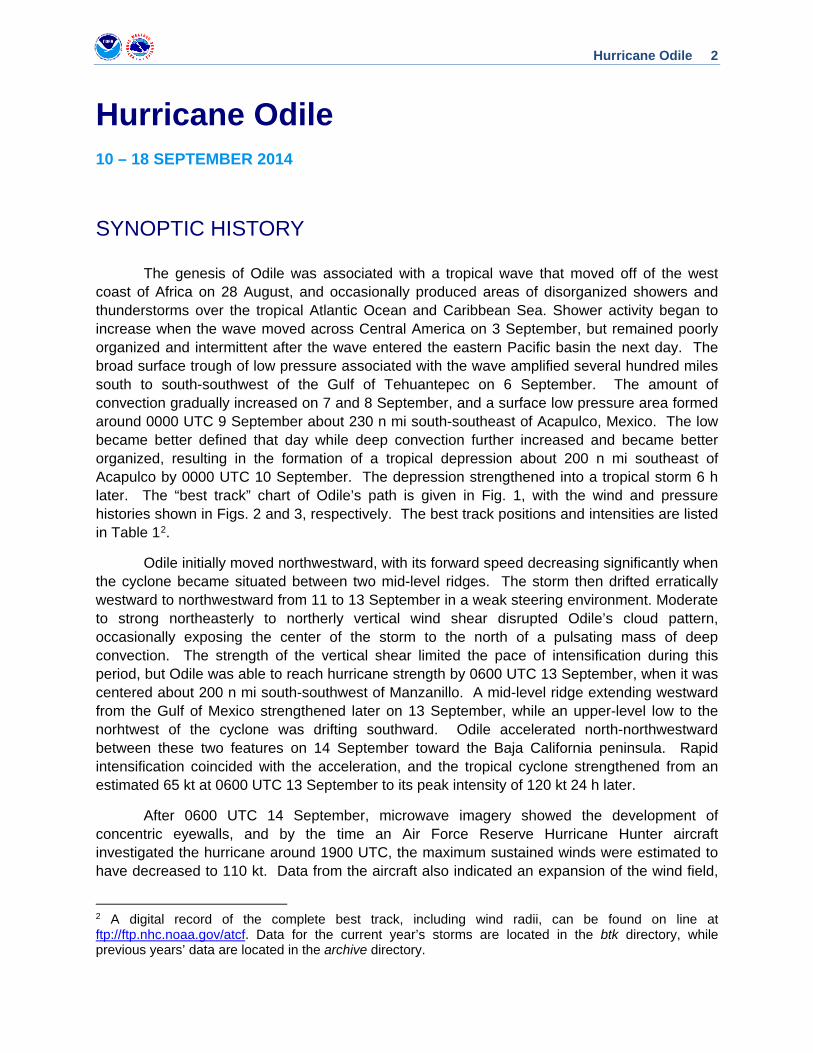
NATIONAL HURRICANE CENTER TROPICAL CYCLONE REPORT HURRICANE ODILE (EP152014) 10 – 18 September 2014 John P. Cangialosi and Todd B. Kimberlain National Hurricane Center 4 March 2015 1 NASA MODIS IMAGE OF HURRICANE ODILE AT 1800 UTC 14 SEPTEMBER 2014 Odile made landfall on the southern tip of the Baja California peninsula as a large category 3 hurricane (on the Saffir-Simpson Hurricane Wind Scale). It was the first major hurricane to strike this region in 25 years and is tied with Hurricane Olivia of 1967 as the strongest landfalling hurricane in Baja California in the historical record. Odile was responsible for 11 direct deaths and over 12 billion pesos (~1 billion USD) of insured losses. 1 Original report date 19 December 2014. Modified 4 March 2015 to correct Table 3.
Transcript of Hurricane Odile · Odile made landfall on the southern tip of the Baja California peninsula as a...
NATIONAL HURRICANE CENTER TROPICAL CYCLONE REPORT
HURRICANE ODILE (EP152014) 10 – 18 September 2014
John P. Cangialosi and Todd B. Kimberlain National Hurricane Center
4 March 20151
NASA MODIS IMAGE OF HURRICANE ODILE AT 1800 UTC 14 SEPTEMBER 2014
Odile made landfall on the southern tip of the Baja California peninsula as a large category 3 hurricane (on the Saffir-Simpson Hurricane Wind Scale). It was the first major hurricane to strike this region in 25 years and is tied with Hurricane Olivia of 1967 as the strongest landfalling hurricane in Baja California in the historical record. Odile was responsible for 11 direct deaths and over 12 billion pesos (~1 billion USD) of insured losses.
1 Original report date 19 December 2014. Modified 4 March 2015 to correct Table 3.
Hurricane Odile 2
Hurricane Odile 10 – 18 SEPTEMBER 2014
SYNOPTIC HISTORY
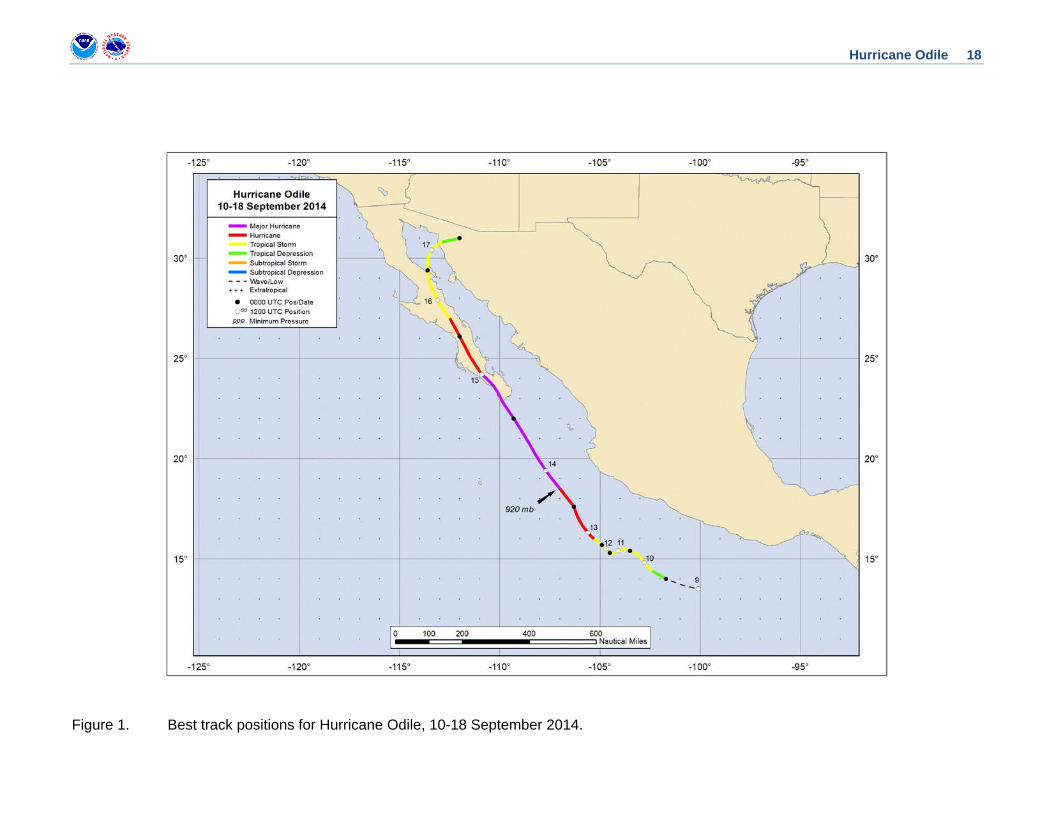
The genesis of Odile was associated with a tropical wave that moved off of the west coast of Africa on 28 August, and occasionally produced areas of disorganized showers and thunderstorms over the tropical Atlantic Ocean and Caribbean Sea. Shower activity began to increase when the wave moved across Central America on 3 September, but remained poorly organized and intermittent after the wave entered the eastern Pacific basin the next day. The broad surface trough of low pressure associated with the wave amplified several hundred miles south to south-southwest of the Gulf of Tehuantepec on 6 September. The amount of convection gradually increased on 7 and 8 September, and a surface low pressure area formed around 0000 UTC 9 September about 230 n mi south-southeast of Acapulco, Mexico. The low became better defined that day while deep convection further increased and became better organized, resulting in the formation of a tropical depression about 200 n mi southeast of Acapulco by 0000 UTC 10 September. The depression strengthened into a tropical storm 6 h later. The “best track” chart of Odile’s path is given in Fig. 1, with the wind and pressure histories shown in Figs. 2 and 3, respectively. The best track positions and intensities are listed in Table 12.
Odile initially moved northwestward, with its forward speed decreasing significantly when the cyclone became situated between two mid-level ridges. The storm then drifted erratically westward to northwestward from 11 to 13 September in a weak steering environment. Moderate to strong northeasterly to northerly vertical wind shear disrupted Odile’s cloud pattern, occasionally exposing the center of the storm to the north of a pulsating mass of deep convection. The strength of the vertical shear limited the pace of intensification during this period, but Odile was able to reach hurricane strength by 0600 UTC 13 September, when it was centered about 200 n mi south-southwest of Manzanillo. A mid-level ridge extending westward from the Gulf of Mexico strengthened later on 13 September, while an upper-level low to the norhtwest of the cyclone was drifting southward. Odile accelerated north-northwestward between these two features on 14 September toward the Baja California peninsula. Rapid intensification coincided with the acceleration, and the tropical cyclone strengthened from an estimated 65 kt at 0600 UTC 13 September to its peak intensity of 120 kt 24 h later.
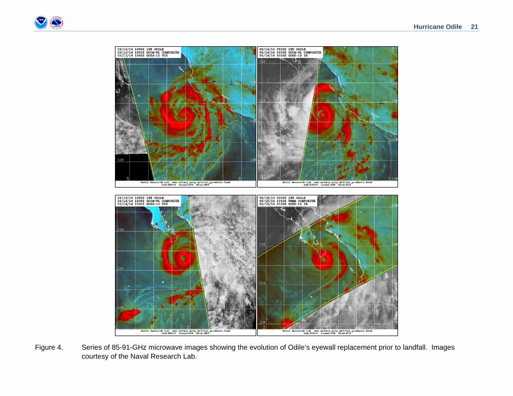
After 0600 UTC 14 September, microwave imagery showed the development of concentric eyewalls, and by the time an Air Force Reserve Hurricane Hunter aircraft investigated the hurricane around 1900 UTC, the maximum sustained winds were estimated to have decreased to 110 kt. Data from the aircraft also indicated an expansion of the wind field,
2 A digital record of the complete best track, including wind radii, can be found on line at ftp://ftp.nhc.noaa.gov/atcf. Data for the current year’s storms are located in the btk directory, while previous years’ data are located in the archive directory.
Hurricane Odile 3
with the tropical-storm-force wind radii nearly doubling in size over the 36 h that Odile had been a hurricane. Odile’s inner eyewall eroded further after the plane departed and nearly dissipated after 0000 UTC 15 September, while the outer eyewall began to contract slightly (Fig. 4). The hurricane further accelerated while Odile’s cloud pattern remained well organized, with a symmetric central dense overcast and a roughly 30 n mi wide eye. Odile made landfall with 110-kt winds (category 3 on the Saffir-Simpson Hurricane Wind Scale) on the southern tip of the Baja California peninsula at 0445 UTC 15 September, just to the east of Cabo San Lucas.
The cyclone moved north-northwestward over Baja California Sur throughout the day, and slowly weakened while it generally moved to the west of the highest topography on the peninsula. Gradually increasing southwesterly shear, and the cyclone’s passage over more rugged terrain disrupted Odile’s inner-core structure, and Odile weakened to a tropical storm around 0600 UTC 16 September while centered about 25 n mi south-southwest of Santa Rosalía in northeastern Baja California Sur. The weakening tropical storm turned northward and then northeastward on 16 and 17 September in response to an approaching mid-latitude trough, and entered the northern Gulf of California, just west of La Isla Angel de la Guarda. Odile then moved inland over the northern part of the Mexican state of Sonora about near Alvaro Obregón about 45 n mi south-southeast of Puerto Peñasco, and weakened to a tropical depression. The depression dissipated by 0600 UTC 18 September over the high terrain of the northern Sierra Madre Occidental mountain range.
METEOROLOGICAL STATISTICS Observations in Odile (Figs. 2 and 3) include subjective satellite-based Dvorak technique intensity estimates from the Tropical Analysis and Forecast Branch (TAFB) and the Satellite Analysis Branch (SAB), and objective Advanced Dvorak Technique (ADT) estimates from the Cooperative Institute for Meteorological Satellite Studies/University of Wisconsin-Madison. Observations also include flight-level, stepped frequency microwave radiometer (SFMR), and dropwindsonde observations from the one flight of the 53rd Weather Reconnaissance Squadron of the U. S. Air Force Reserve Command. Data and imagery from NOAA polar-orbiting satellites including the Advanced Microwave Sounding Unit (AMSU), the NASA Tropical Rainfall Measuring Mission (TRMM), the European Space Agency’s Advanced Scatterometer (ASCAT), and Defense Meteorological Satellite Program (DMSP) satellites, among others, were also useful in constructing the best track of Odile.
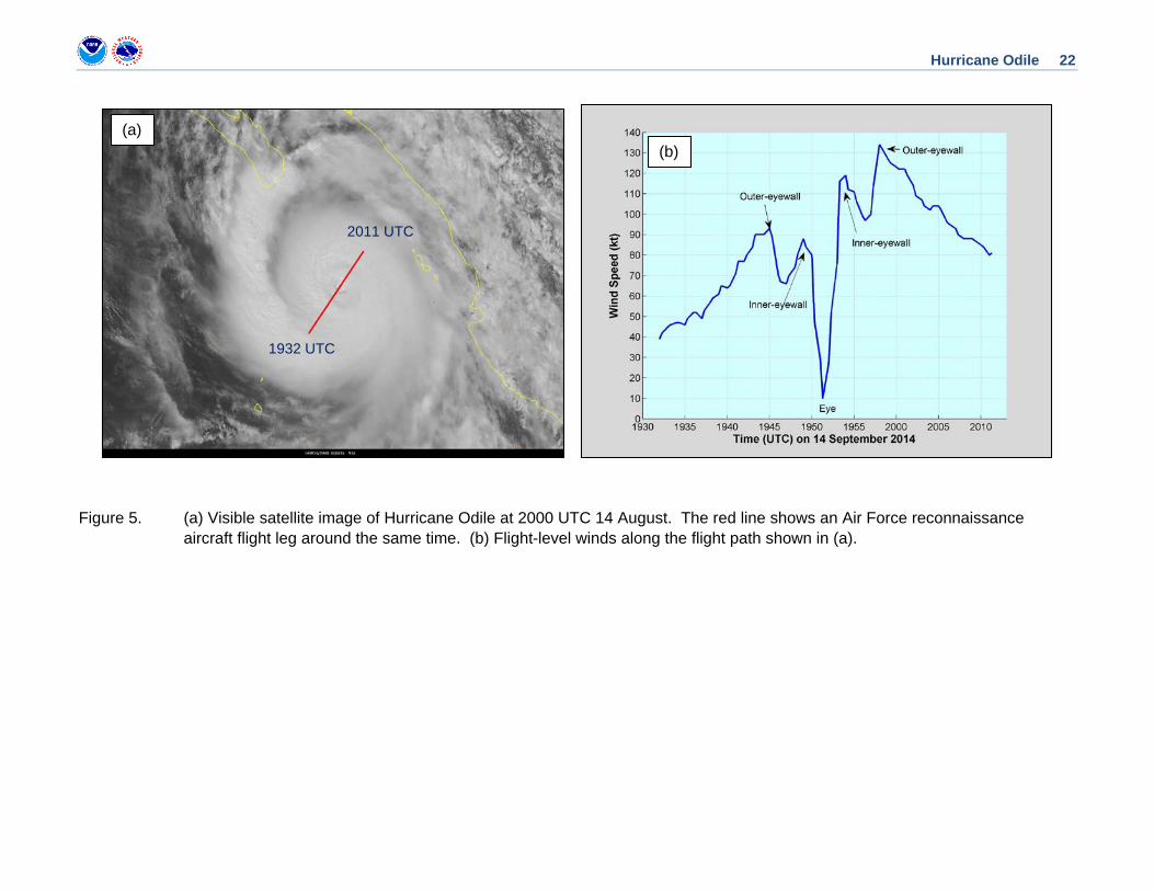
Winds and Pressure Odile’s estimated peak intensity of 120 kt at 0600 UTC 14 September is based on T6.0/115 kt satellite classifications from TAFB and SAB, a 120-kt AMSU estimate, as well as aircraft data from later that day after Odile’s satellite appearance had begun to lose organization. The maximum observed flight-level (700-mb) wind was 134 kt in the northeast quadrant of the circulation at 1957 UTC, and the minimum observed pressure was 923 mb. The maximum SFMR observation was 100 kt around 2000 UTC. The aircraft observed distinct double wind maxima (Fig. 5), indicative of an ongoing eyewall replacement. The large
Hurricane Odile 4
difference between the peak flight-level and SFMR winds is typical in tropical cyclones with concentric wind maxima.
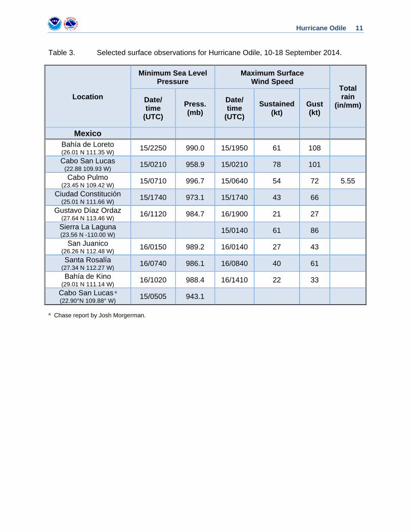
The estimated landfall intensity of 110 kt at 0445 UTC 15 September is based on aircraft data from late on 14 September and the stable satellite presentation from that point until landfall. An observation of 943.1 mb with about 20 kt winds at 0505 UTC 15 September was measured by a storm chaser at the Holiday Inn Express in Cabo San Lucas, Baja California Sur (22.90231°N and 109.88354° W). Based on this observation, which is judged to be very near Odile’s center at landfall, the estimated landfall pressure is 941 mb.
The cargo ship Cap Portland (call sign A8MQ9) reported 35-kt winds at 1800 14 September near the southwestern coast of Mexico. Selected surface observations from land stations are given in Table 3. A 1-min sustained wind of nearly 80 kt was reported at the Cabo San Lucas International Airport. A couple of reports of wind gusts of over 100 kt were also received, including an unofficial 108-kt wind gust at Bahia de Loreto. Hurricane conditions likely occurred over a large portion of the Baja California Sur. Tropical storm conditions also likely occurred over an even wider area, with most of the Baja California peninsula experiencing winds of this strength.
Odile is the third major hurricane to make landfall on the Baja California peninsula in the satellite era (Olivia of 1967 and Kiko of 1989 were the other two), and ties Hurricane Olivia as the strongest tropical cyclone to affect the Baja California peninsula in the observational record. It is also the strongest landfalling tropical cyclone on the Baja California peninsula since Hurricane John of 2006. Odile is also the first tropical storm to make landfall north of 30°N in Mexico since Hurricane Nora of 1997.
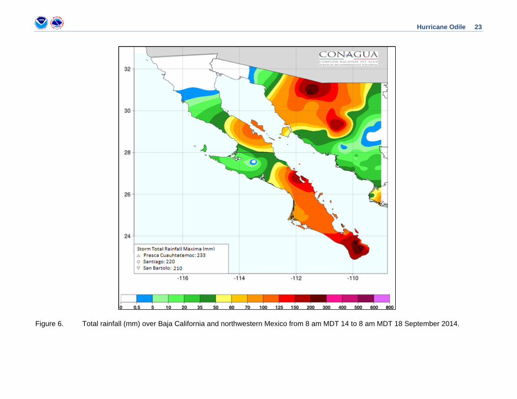
Rainfall and Flooding Data from Mexico’s Servicio Meteorológico Nacional (SMN) indicate that Odile produced an extensive area of heavy rains of 4 to 6 inches over much of the Baja California peninsula. A maximum rainfall total of about 8.67 inches (220 mm) occurred in Santiago in Baja California Sur. In addition, rainfall totals of 4 to 8 inches occurred in the state of Sonora and the eastern portion of the state of Chihuahua in Mexico. The observed maximum rainfall total was about 9.17 inches (233 mm) in Preca Cuauhtemoc in the state of Sonora (Fig. 6).
The remnants of Odile also brought heavy rains to portions of the southwestern and south-central United States, with 5 to 10 inches of rain occurring across extreme southeastern Arizona, southern New Mexico, and western Texas. A few areas observed rainfall totals over 10 inches (254 mm), including Gail, Texas, were 15.31 inches (389 mm) of rain fell, and Pine Springs, Texas, where 12.78 inches (325 mm) was measured. Carlsbad, New Mexico reported a rainfall total of 10.36 inches (263 mm).
Hurricane Odile 5
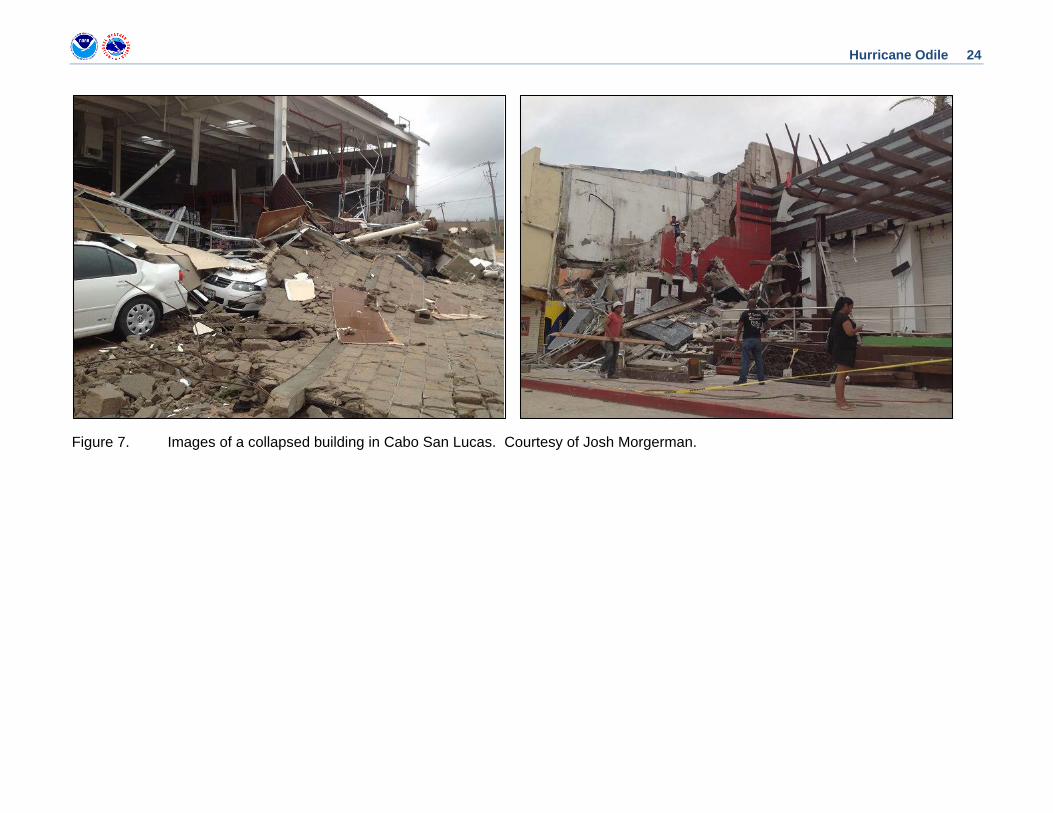
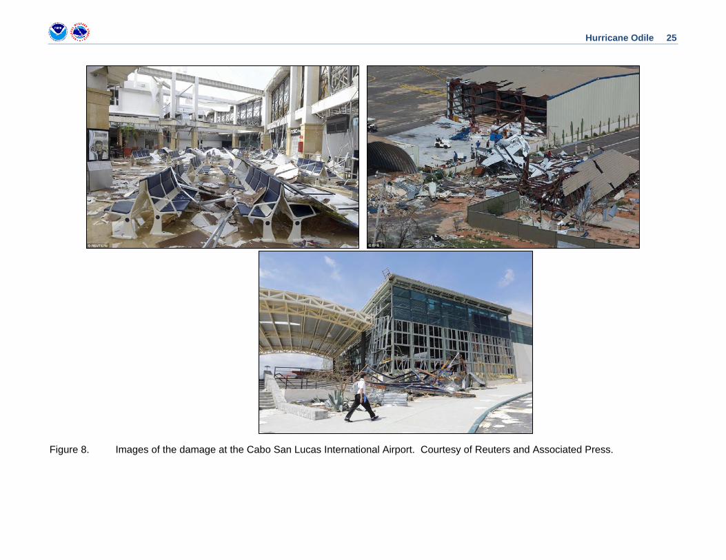
CASUALTY AND DAMAGE STATISTICS Odile was the first major hurricane to strike the Baja California peninsula in 25 years and the most destructive tropical cyclone on record to affect this region. Media reports indicate that the hurricane caused widespread severe damage over Baja California Sur, with strong winds toppling trees, power lines, and street signs (Fig. 7). Windows were blown out of many of the luxury high-rise hotels lining the shore of Cabo San Lucas and adjacent areas, with several hotels collapsing or inundated by water. Odile devastated the region’s electrical infrastructure, taking out about 550 high-tension transmission towers and 3,400 distribution posts. The government of Mexico reported that over 239,000 people (over 90% of the population) were left without electricity in the Baja California Sur. The Cabo San Lucas International Airport was badly damaged (Fig. 8) and 3,000 to 4,000 people were stranded due to cancelled flights. Except for shipments of humanitarian relief, flights into and out of the airport were suspended until about a month after Odile’s landfall. In the city of San José del Cabo, severe damage was reported, with drinking water unavailable and communications left inoperative. The hurricane left thousands homeless in that town, and many in the state’s more rural and adjacent communities became completely isolated. Other media sources described the devastation that extended northward along the west coast of Baja Calfornia Sur, with communities such as Todos Santos, Pescadero and Sierra de Laguna badly affected. In these towns, many people lost virtually everything that they owned. The hurricane produced considerable damage in the coastal city of La Paz, where up to 10,000 inhabitants were left homeless. Boats were capsized or pushed onshore, presumably as a result of the storm surge. In Loreto, Comandú, and Mulege, strong winds combined with heavy rains to wash away roads and destroy bridges, making transportation and relief activities difficult. In Bahía de los Angeles, severe flooding made the main roadway impassable, trapping around 90 families for many days.
Based on media reports, a total of eleven direct deaths3 are attributed to Odile, with 8 deaths and at least 135 injuries reported in Baja California Sur. Two Korean mining executives crossing a flooded stream in Santa Rosalía drowned, and another man was swept away when crossing the Santa Rosa stream in Cabo San José del Cabo in his car. A 28-year-old man attempting to cross a flooded roadway in his pickup truck also drowned. The body of a 45-year old British female tourist was found in a mangrove thicket near La Paz, apparently having drowned there. Her husband, who had been living with her on a yacht in the La Paz harbor, was initially reported missing, but has since been confirmed dead after a search and rescue operation. Two other deaths in Baja California Sur were reported as a result of the storm, one in the community of Todos Santos and one in Pescadero.
Odile’s impacts extended well away from the center of the storm. Dangerous surf and swells from the hurricane battered coastal areas of Mexico from Oaxaca northward through Baja California. High waves inundated several businesses and other structures in Guerrero, resulting in the damage of nearly 70 buildings from Zihuatenajo to Acapulco, including a portion of a
3 Deaths occurring as a direct result of the forces of the tropical cyclone are referred to as “direct” deaths. These would include those persons who drowned in storm surge, rough seas, rip currents, and freshwater floods. Direct deaths also include casualties resulting from lightning and wind-related events (e.g., collapsing structures). Deaths occurring from such factors as heart attacks, house fires, electrocutions from downed power lines, vehicle accidents on wet roads, etc., are considered indirect” deaths.
Hurricane Odile 6
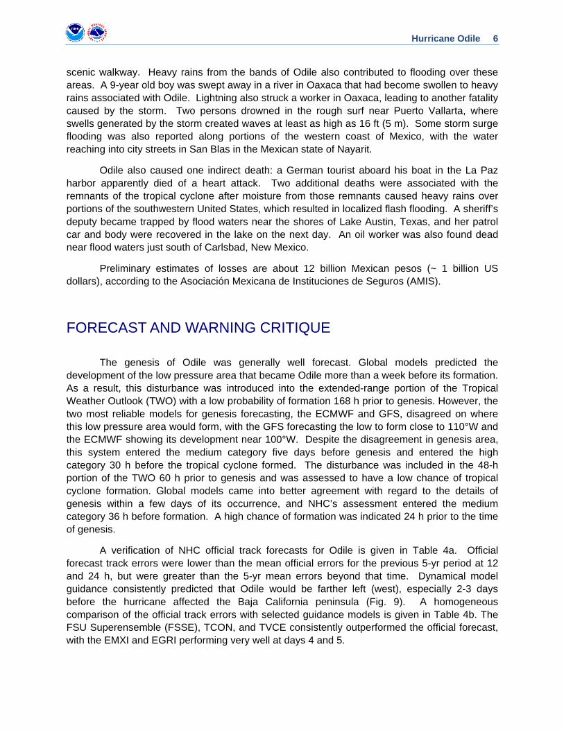
scenic walkway. Heavy rains from the bands of Odile also contributed to flooding over these areas. A 9-year old boy was swept away in a river in Oaxaca that had become swollen to heavy rains associated with Odile. Lightning also struck a worker in Oaxaca, leading to another fatality caused by the storm. Two persons drowned in the rough surf near Puerto Vallarta, where swells generated by the storm created waves at least as high as 16 ft (5 m). Some storm surge flooding was also reported along portions of the western coast of Mexico, with the water reaching into city streets in San Blas in the Mexican state of Nayarit.
Odile also caused one indirect death: a German tourist aboard his boat in the La Paz harbor apparently died of a heart attack. Two additional deaths were associated with the remnants of the tropical cyclone after moisture from those remnants caused heavy rains over portions of the southwestern United States, which resulted in localized flash flooding. A sheriff’s deputy became trapped by flood waters near the shores of Lake Austin, Texas, and her patrol car and body were recovered in the lake on the next day. An oil worker was also found dead near flood waters just south of Carlsbad, New Mexico.
Preliminary estimates of losses are about 12 billion Mexican pesos (~ 1 billion US dollars), according to the Asociación Mexicana de Instituciones de Seguros (AMIS).
FORECAST AND WARNING CRITIQUE
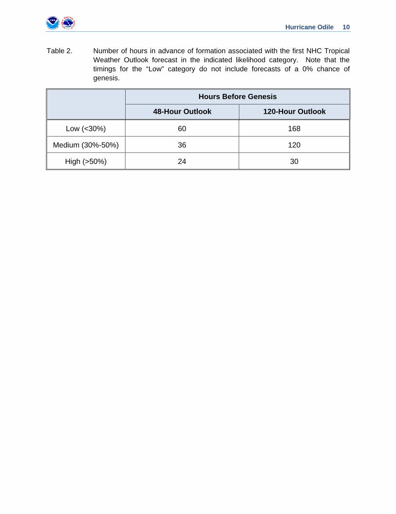
The genesis of Odile was generally well forecast. Global models predicted the development of the low pressure area that became Odile more than a week before its formation. As a result, this disturbance was introduced into the extended-range portion of the Tropical Weather Outlook (TWO) with a low probability of formation 168 h prior to genesis. However, the two most reliable models for genesis forecasting, the ECMWF and GFS, disagreed on where this low pressure area would form, with the GFS forecasting the low to form close to 110°W and the ECMWF showing its development near 100°W. Despite the disagreement in genesis area, this system entered the medium category five days before genesis and entered the high category 30 h before the tropical cyclone formed. The disturbance was included in the 48-h portion of the TWO 60 h prior to genesis and was assessed to have a low chance of tropical cyclone formation. Global models came into better agreement with regard to the details of genesis within a few days of its occurrence, and NHC’s assessment entered the medium category 36 h before formation. A high chance of formation was indicated 24 h prior to the time of genesis.
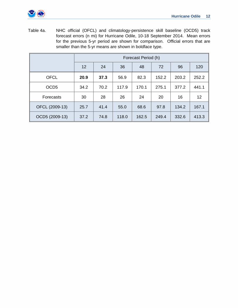
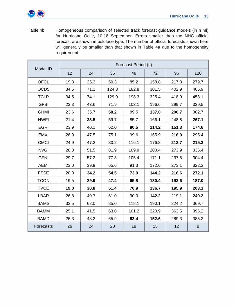
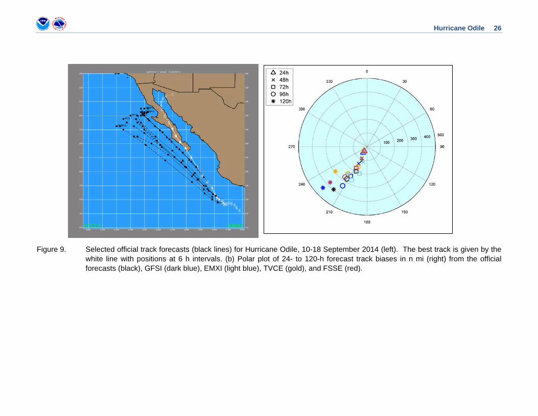
A verification of NHC official track forecasts for Odile is given in Table 4a. Official forecast track errors were lower than the mean official errors for the previous 5-yr period at 12 and 24 h, but were greater than the 5-yr mean errors beyond that time. Dynamical model guidance consistently predicted that Odile would be farther left (west), especially 2-3 days before the hurricane affected the Baja California peninsula (Fig. 9). A homogeneous comparison of the official track errors with selected guidance models is given in Table 4b. The FSU Superensemble (FSSE), TCON, and TVCE consistently outperformed the official forecast, with the EMXI and EGRI performing very well at days 4 and 5.
Hurricane Odile 7
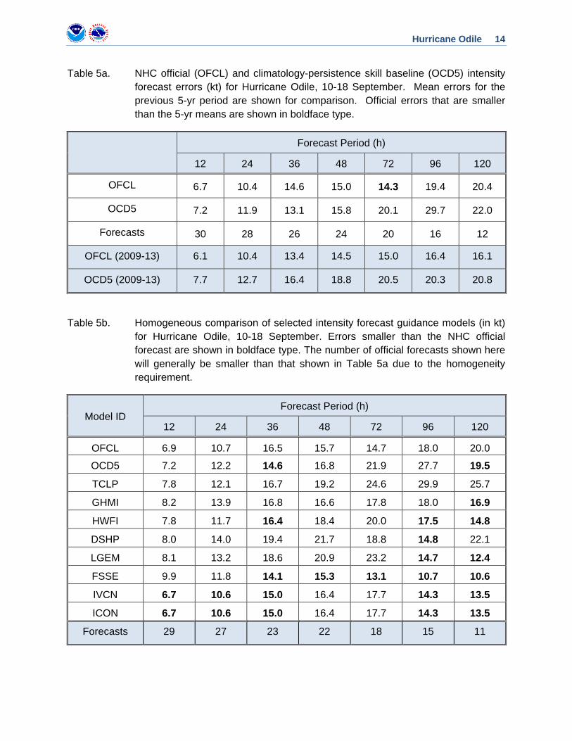
A verification of NHC official intensity forecasts for Odile is given in Table 5a. Official forecast intensity errors were greater than the mean official errors for the previous 5-yr period, except at 72 h. Although the official forecasts captured Odile’s slow rate of intensification early in its lifecycle, they did not anticipate the rapid intensification because of the poor organization of the cyclone’s inner core and the large size of the cyclone’s circulation. A homogeneous comparison of the official intensity errors with selected guidance models is given in Table 5b. The best-performing intensity models were the consensus aids (IVCN and FSSE), which bested the official forecast at a few forecast time periods.
Watches and warnings associated with Odile are listed in Table 6. Official track forecasts generally followed the left-biased numerical model guidance, causing a delay in the perceived threat to the Baja California peninsula; the track guidance and the NHC official forecast therefore did not fully describe the threat to the Baja California until about a day before landfall.
ACKNOWLEDGEMENTS We are grateful to Josh Morgerman of iCyclone for providing detailed pressure
observations and an eyewitness account of conditions in Cabo San Lucas during the height of the storm. We also appreciate Juan Manuel Caballero Gónzalez, Alberto Hernández Unzón, Carlos Garrido, and other colleagues within Mexico’s SMN for providing data and other information useful to this report.
Hurricane Odile 8
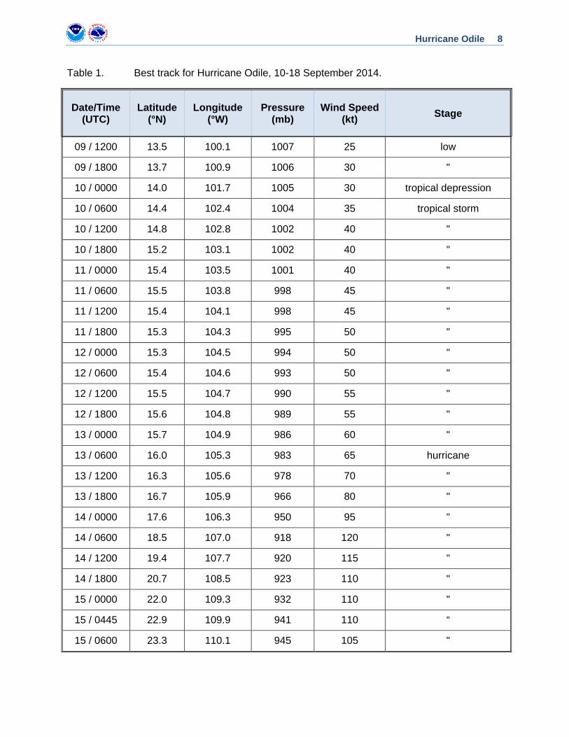
Table 1. Best track for Hurricane Odile, 10-18 September 2014.
Date/Time (UTC)
Latitude (°N)
Longitude (°W)
Pressure (mb)
Wind Speed (kt) Stage
09 / 1200 13.5 100.1 1007 25 low
09 / 1800 13.7 100.9 1006 30 "
10 / 0000 14.0 101.7 1005 30 tropical depression
10 / 0600 14.4 102.4 1004 35 tropical storm
10 / 1200 14.8 102.8 1002 40 "
10 / 1800 15.2 103.1 1002 40 "
11 / 0000 15.4 103.5 1001 40 "
11 / 0600 15.5 103.8 998 45 "
11 / 1200 15.4 104.1 998 45 "
11 / 1800 15.3 104.3 995 50 "
12 / 0000 15.3 104.5 994 50 "
12 / 0600 15.4 104.6 993 50 "
12 / 1200 15.5 104.7 990 55 "
12 / 1800 15.6 104.8 989 55 "
13 / 0000 15.7 104.9 986 60 "
13 / 0600 16.0 105.3 983 65 hurricane
13 / 1200 16.3 105.6 978 70 "
13 / 1800 16.7 105.9 966 80 "
14 / 0000 17.6 106.3 950 95 "
14 / 0600 18.5 107.0 918 120 "
14 / 1200 19.4 107.7 920 115 "
14 / 1800 20.7 108.5 923 110 "
15 / 0000 22.0 109.3 932 110 "
15 / 0445 22.9 109.9 941 110 “
15 / 0600 23.3 110.1 945 105 "
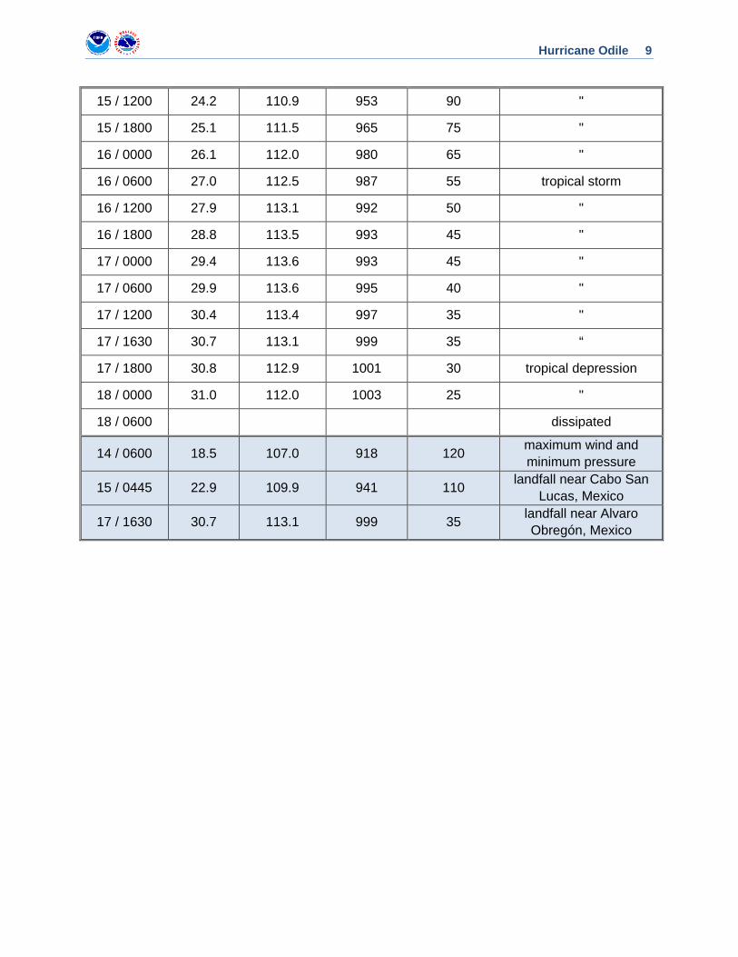
Hurricane Odile 9
15 / 1200 24.2 110.9 953 90 "
15 / 1800 25.1 111.5 965 75 "
16 / 0000 26.1 112.0 980 65 "
16 / 0600 27.0 112.5 987 55 tropical storm
16 / 1200 27.9 113.1 992 50 "
16 / 1800 28.8 113.5 993 45 "
17 / 0000 29.4 113.6 993 45 "
17 / 0600 29.9 113.6 995 40 "
17 / 1200 30.4 113.4 997 35 "
17 / 1630 30.7 113.1 999 35 “
17 / 1800 30.8 112.9 1001 30 tropical depression
18 / 0000 31.0 112.0 1003 25 "
18 / 0600 dissipated
14 / 0600 18.5 107.0 918 120 maximum wind and minimum pressure
15 / 0445 22.9 109.9 941 110 landfall near Cabo San Lucas, Mexico
17 / 1630 30.7 113.1 999 35 landfall near Alvaro Obregón, Mexico
Hurricane Odile 10
Table 2. Number of hours in advance of formation associated with the first NHC Tropical Weather Outlook forecast in the indicated likelihood category. Note that the timings for the “Low” category do not include forecasts of a 0% chance of genesis.
Hours Before Genesis
48-Hour Outlook 120-Hour Outlook
Low (<30%) 60 168
Medium (30%-50%) 36 120
High (>50%) 24 30
Hurricane Odile 11
Table 3. Selected surface observations for Hurricane Odile, 10-18 September 2014.
Location
Minimum Sea Level Pressure
Maximum Surface Wind Speed
Total rain
(in/mm) Date/ time
(UTC) Press. (mb)
Date/ time
(UTC)
Sustained (kt)
Gust (kt)
Mexico Bahía de Loreto (26.01 N 111.35 W) 15/2250 990.0 15/1950 61 108
Cabo San Lucas (22.88 109.93 W) 15/0210 958.9 15/0210 78 101
Cabo Pulmo (23.45 N 109.42 W) 15/0710 996.7 15/0640 54 72 5.55
Ciudad Constitución (25.01 N 111.66 W) 15/1740 973.1 15/1740 43 66
Gustavo Díaz Ordaz (27.64 N 113.46 W) 16/1120 984.7 16/1900 21 27
Sierra La Laguna (23.56 N -110.00 W) 15/0140 61 86
San Juanico (26.26 N 112.48 W) 16/0150 989.2 16/0140 27 43
Santa Rosalía (27.34 N 112.27 W) 16/0740 986.1 16/0840 40 61
Bahía de Kino (29.01 N 111.14 W) 16/1020 988.4 16/1410 22 33
Cabo San Lucas a
(22.90°N 109.88° W) 15/0505 943.1
a Chase report by Josh Morgerman.
Hurricane Odile 12
Table 4a. NHC official (OFCL) and climatology-persistence skill baseline (OCD5) track forecast errors (n mi) for Hurricane Odile, 10-18 September 2014. Mean errors for the previous 5-yr period are shown for comparison. Official errors that are smaller than the 5-yr means are shown in boldface type.
Forecast Period (h)
12 24 36 48 72 96 120
OFCL 20.9 37.3 56.9 82.3 152.2 203.2 252.2
OCD5 34.2 70.2 117.9 170.1 275.1 377.2 441.1
Forecasts 30 28 26 24 20 16 12
OFCL (2009-13) 25.7 41.4 55.0 68.6 97.8 134.2 167.1
OCD5 (2009-13) 37.2 74.8 118.0 162.5 249.4 332.6 413.3
Hurricane Odile 13
Table 4b. Homogeneous comparison of selected track forecast guidance models (in n mi) for Hurricane Odile, 10-18 September. Errors smaller than the NHC official forecast are shown in boldface type. The number of official forecasts shown here will generally be smaller than that shown in Table 4a due to the homogeneity requirement.
Model ID Forecast Period (h)
12 24 36 48 72 96 120
OFCL 19.3 35.3 59.3 85.2 158.8 217.3 279.7
OCD5 34.5 71.1 124.3 182.8 301.5 402.9 466.9
TCLP 34.5 74.1 129.9 198.3 325.4 418.9 453.1
GFSI 23.3 43.6 71.9 103.1 196.6 299.7 339.5
GHMI 23.6 35.7 58.2 89.5 137.0 200.7 302.7
HWFI 21.4 33.5 59.7 85.7 166.1 248.8 267.1
EGRI 23.9 40.1 62.0 80.5 114.2 151.3 174.6
EMXI 26.9 47.5 75.1 99.6 165.9 216.9 295.4
CMCI 24.9 47.2 80.2 116.1 176.8 212.7 215.3
NVGI 28.0 51.5 81.9 109.9 200.4 273.9 336.4
GFNI 29.7 57.2 77.3 105.4 171.1 237.8 304.4
AEMI 23.0 39.9 65.6 91.3 172.6 273.1 322.3
FSSE 20.0 34.2 54.5 73.9 144.2 216.6 272.1
TCON 19.5 29.9 47.4 65.8 130.4 193.6 187.0
TVCE 19.0 30.8 51.4 70.9 136.7 195.9 203.1
LBAR 26.8 40.7 61.0 90.0 142.2 219.1 249.2
BAMS 33.5 62.0 85.0 118.1 190.1 324.2 369.7
BAMM 25.1 41.5 63.0 101.2 220.9 363.5 396.2
BAMD 26.3 48.2 65.9 83.4 152.6 289.3 385.2
Forecasts 26 24 20 19 15 12 8
Hurricane Odile 14
Table 5a. NHC official (OFCL) and climatology-persistence skill baseline (OCD5) intensity forecast errors (kt) for Hurricane Odile, 10-18 September. Mean errors for the previous 5-yr period are shown for comparison. Official errors that are smaller than the 5-yr means are shown in boldface type.
Forecast Period (h)
12 24 36 48 72 96 120
OFCL 6.7 10.4 14.6 15.0 14.3 19.4 20.4
OCD5 7.2 11.9 13.1 15.8 20.1 29.7 22.0
Forecasts 30 28 26 24 20 16 12
OFCL (2009-13) 6.1 10.4 13.4 14.5 15.0 16.4 16.1
OCD5 (2009-13) 7.7 12.7 16.4 18.8 20.5 20.3 20.8
Table 5b. Homogeneous comparison of selected intensity forecast guidance models (in kt) for Hurricane Odile, 10-18 September. Errors smaller than the NHC official forecast are shown in boldface type. The number of official forecasts shown here will generally be smaller than that shown in Table 5a due to the homogeneity requirement.
Model ID Forecast Period (h)
12 24 36 48 72 96 120
OFCL 6.9 10.7 16.5 15.7 14.7 18.0 20.0
OCD5 7.2 12.2 14.6 16.8 21.9 27.7 19.5
TCLP 7.8 12.1 16.7 19.2 24.6 29.9 25.7
GHMI 8.2 13.9 16.8 16.6 17.8 18.0 16.9
HWFI 7.8 11.7 16.4 18.4 20.0 17.5 14.8
DSHP 8.0 14.0 19.4 21.7 18.8 14.8 22.1
LGEM 8.1 13.2 18.6 20.9 23.2 14.7 12.4
FSSE 9.9 11.8 14.1 15.3 13.1 10.7 10.6
IVCN 6.7 10.6 15.0 16.4 17.7 14.3 13.5
ICON 6.7 10.6 15.0 16.4 17.7 14.3 13.5
Forecasts 29 27 23 22 18 15 11

Hurricane Odile 15
Table 6. Watch and warning summary for Hurricane Odile, 10-18 September 2014.
Date/Time (UTC) Action Location
11 / 0300 Tropical Storm Watch issued Lazaro Cárdenas to Manzanillo
12 / 0300 Tropical Storm Watch modified to Manzanillo to Cabo Corrientes
13 / 0900 Tropical Storm Watch issued La Paz to Santa Fe
13 / 2100 Tropical Storm Watch changed to Tropical Storm Warning
La Paz to Santa Fe
13 / 2100 Tropical Storm Watch issued La Paz to Loreto
13 / 2100 Hurricane Watch issued Cabo San Lázaro to La Paz
14 / 0300 Tropical Storm Watch changed to Tropical Storm Warning
Manzanillo to Cabo Corrientes
14 / 0300 Tropical Storm Watch changed to Tropical Storm Warning
La Paz to Loreto
14 / 0300 Tropical Storm Watch changed to Hurricane Watch
La Paz to Loreto
14 / 0300 Hurricane Watch changed to Hurricane Warning
Cabo San Lázaro to La Paz
14 / 0300 Tropical Storm Watch issued Puerto San Andresito to Punta Abreojos
14 / 0300 Tropical Storm Watch issued Loreto to Mulege
14 / 0300 Tropical Storm Warning modified to La Paz to Loreto
14 / 0300 Hurricane Watch issued Cabo San Lázaro to Puerto San Andresito
14 / 0900 Tropical Storm Warning changed to Hurricane Watch
La Paz to Loreto
14 / 0900 Tropical Storm Watch discontinued Puerto San Andresito to Punta Abreojos
14 / 0900 Tropical Storm Watch modified to Mulege to Santa Rosalía
14 / 0900 Tropical Storm Warning issued La Paz to Mulege
14 / 0900 Hurricane Watch modified to Puerto San Andresito to Punta Eugenia
14 / 0900 Hurricane Warning modified to Puerto San Andresito to La Paz
14 / 1500 Tropical Storm Watch modified to Santa Rosalía to Bahía San Juan Bautista
14 / 1500 Tropical Storm Warning modified to La Paz to Santa Rosalía
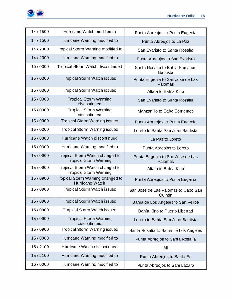
Hurricane Odile 16
14 / 1500 Hurricane Watch modified to Punta Abreojos to Punta Eugenia
14 / 1500 Hurricane Warning modified to Punta Abreojos to La Paz
14 / 2300 Tropical Storm Warning modified to San Evaristo to Santa Rosalía
14 / 2300 Hurricane Warning modified to Punta Abreojos to San Evaristo
15 / 0300 Tropical Storm Watch discontinued Santa Rosalía to Bahía San Juan Bautista
15 / 0300 Tropical Storm Watch issued Punta Eugenia to San José de Las Palomas
15 / 0300 Tropical Storm Watch issued Altata to Bahía Kino
15 / 0300 Tropical Storm Warning discontinued
San Evaristo to Santa Rosalía
15 / 0300 Tropical Storm Warning discontinued
Manzanillo to Cabo Corrientes
15 / 0300 Tropical Storm Warning issued Punta Abreojos to Punta Eugenia
15 / 0300 Tropical Storm Warning issued Loreto to Bahía San Juan Bautista
15 / 0300 Hurricane Watch discontinued La Paz to Loreto
15 / 0300 Hurricane Warning modified to Punta Abreojos to Loreto
15 / 0900 Tropical Storm Watch changed to Tropical Storm Warning
Punta Eugenia to San José de Las Palomas
15 / 0900 Tropical Storm Watch changed to Tropical Storm Warning
Altata to Bahía Kino
15 / 0900 Tropical Storm Warning changed to Hurricane Watch
Punta Abreojos to Punta Eugenia
15 / 0900 Tropical Storm Watch issued San José de Las Palomas to Cabo San Quintín
15 / 0900 Tropical Storm Watch issued Bahía de Los Angeles to San Felipe
15 / 0900 Tropical Storm Watch issued Bahía Kino to Puerto Libertad
15 / 0900 Tropical Storm Warning discontinued
Loreto to Bahía San Juan Bautista
15 / 0900 Tropical Storm Warning issued Santa Rosalía to Bahía de Los Angeles
15 / 0900 Hurricane Warning modified to Punta Abreojos to Santa Rosalía
15 / 2100 Hurricane Watch discontinued All
15 / 2100 Hurricane Warning modified to Punta Abreojos to Santa Fe
16 / 0000 Hurricane Warning modified to Punta Abreojos to Sam Lázaro
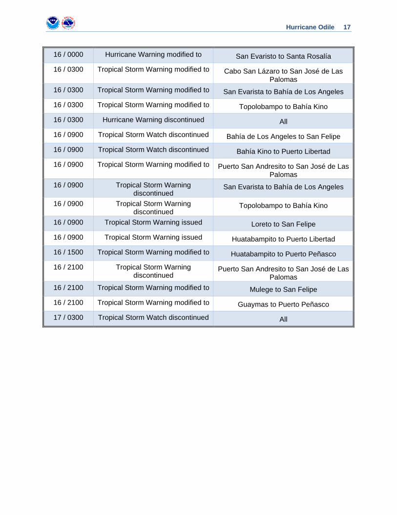
Hurricane Odile 17
16 / 0000 Hurricane Warning modified to San Evaristo to Santa Rosalía
16 / 0300 Tropical Storm Warning modified to Cabo San Lázaro to San José de Las Palomas
16 / 0300 Tropical Storm Warning modified to San Evarista to Bahía de Los Angeles
16 / 0300 Tropical Storm Warning modified to Topolobampo to Bahía Kino
16 / 0300 Hurricane Warning discontinued All
16 / 0900 Tropical Storm Watch discontinued Bahía de Los Angeles to San Felipe
16 / 0900 Tropical Storm Watch discontinued Bahía Kino to Puerto Libertad
16 / 0900 Tropical Storm Warning modified to Puerto San Andresito to San José de Las Palomas
16 / 0900 Tropical Storm Warning discontinued
San Evarista to Bahía de Los Angeles
16 / 0900 Tropical Storm Warning discontinued
Topolobampo to Bahía Kino
16 / 0900 Tropical Storm Warning issued Loreto to San Felipe
16 / 0900 Tropical Storm Warning issued Huatabampito to Puerto Libertad
16 / 1500 Tropical Storm Warning modified to Huatabampito to Puerto Peñasco
16 / 2100 Tropical Storm Warning discontinued
Puerto San Andresito to San José de Las Palomas
16 / 2100 Tropical Storm Warning modified to Mulege to San Felipe
16 / 2100 Tropical Storm Warning modified to Guaymas to Puerto Peñasco
17 / 0300 Tropical Storm Watch discontinued All
Hurricane Odile 18
Figure 1. Best track positions for Hurricane Odile, 10-18 September 2014.
Hurricane Odile 19
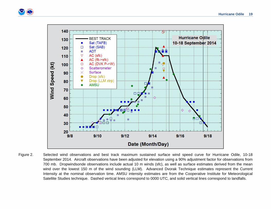
Figure 2. Selected wind observations and best track maximum sustained surface wind speed curve for Hurricane Odile, 10-18 September 2014. Aircraft observations have been adjusted for elevation using a 90% adjustment factor for observations from 700 mb. Dropwindsonde observations include actual 10 m winds (sfc), as well as surface estimates derived from the mean wind over the lowest 150 m of the wind sounding (LLM). Advanced Dvorak Technique estimates represent the Current Intensity at the nominal observation time. AMSU intensity estimates are from the Cooperative Institute for Meteorological Satellite Studies technique. Dashed vertical lines correspond to 0000 UTC, and solid vertical lines correspond to landfalls.
Hurricane Odile 20
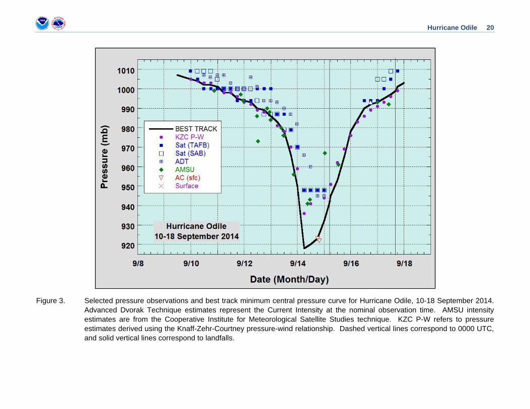
Figure 3. Selected pressure observations and best track minimum central pressure curve for Hurricane Odile, 10-18 September 2014. Advanced Dvorak Technique estimates represent the Current Intensity at the nominal observation time. AMSU intensity estimates are from the Cooperative Institute for Meteorological Satellite Studies technique. KZC P-W refers to pressure estimates derived using the Knaff-Zehr-Courtney pressure-wind relationship. Dashed vertical lines correspond to 0000 UTC, and solid vertical lines correspond to landfalls.
Hurricane Odile 21
Figure 4. Series of 85-91-GHz microwave images showing the evolution of Odile’s eyewall replacement prior to landfall. Images courtesy of the Naval Research Lab.
Hurricane Odile 22
Figure 5. (a) Visible satellite image of Hurricane Odile at 2000 UTC 14 August. The red line shows an Air Force reconnaissance aircraft flight leg around the same time. (b) Flight-level winds along the flight path shown in (a).
(a) (b)
1932 UTC
2011 UTC
Hurricane Odile 23
Figure 6. Total rainfall (mm) over Baja California and northwestern Mexico from 8 am MDT 14 to 8 am MDT 18 September 2014.
Hurricane Odile 24
Figure 7. Images of a collapsed building in Cabo San Lucas. Courtesy of Josh Morgerman.
Hurricane Odile 25
Figure 8. Images of the damage at the Cabo San Lucas International Airport. Courtesy of Reuters and Associated Press.
Hurricane Odile 26
Figure 9. Selected official track forecasts (black lines) for Hurricane Odile, 10-18 September 2014 (left). The best track is given by the white line with positions at 6 h intervals. (b) Polar plot of 24- to 120-h forecast track biases in n mi (right) from the official forecasts (black), GFSI (dark blue), EMXI (light blue), TVCE (gold), and FSSE (red).