Hurontario/Main Street Corridor Master Plan Mississauga...
10
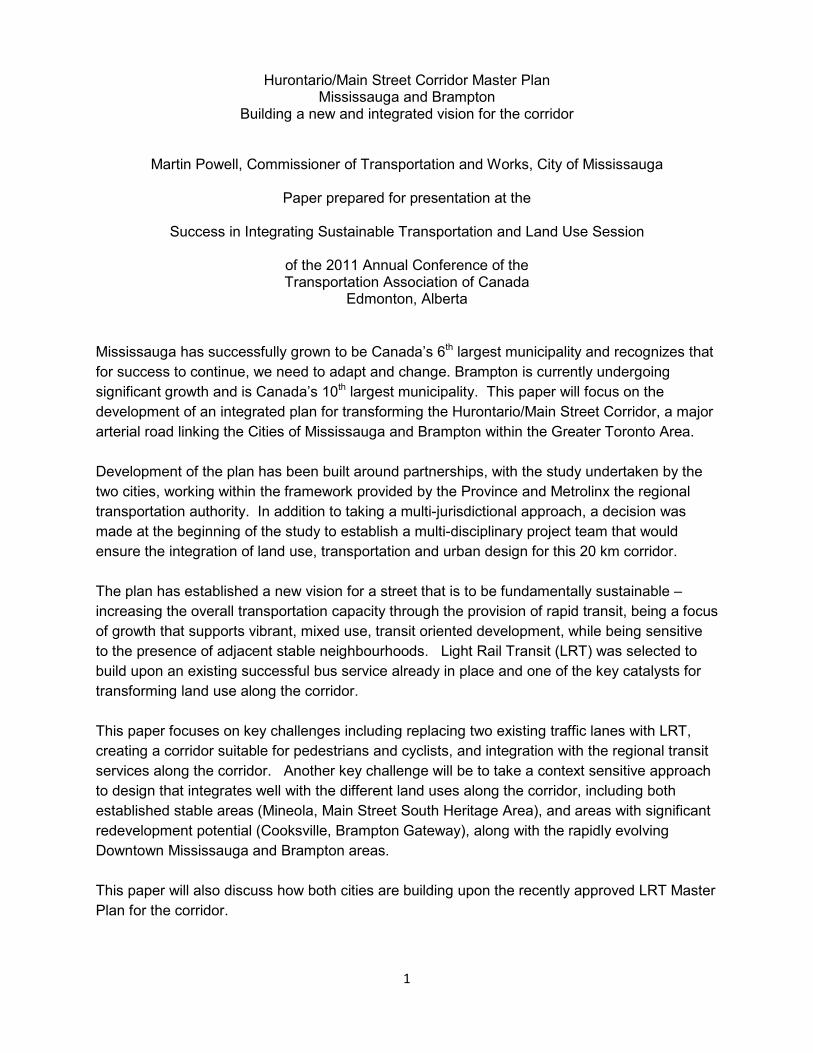
1 Hurontario/Main Street Corridor Master Plan Mississauga and Brampton Building a new and integrated vision for the corridor Martin Powell, Commissioner of Transportation and Works, City of Mississauga Paper prepared for presentation at the Success in Integrating Sustainable Transportation and Land Use Session of the 2011 Annual Conference of the Transportation Association of Canada Edmonton, Alberta Mississauga has successfully grown to be Canada’s 6 th largest municipality and recognizes that for success to continue, we need to adapt and change. Brampton is currently undergoing significant growth and is Canada’s 10 th largest municipality. This paper will focus on the development of an integrated plan for transforming the Hurontario/Main Street Corridor, a major arterial road linking the Cities of Mississauga and Brampton within the Greater Toronto Area. Development of the plan has been built around partnerships, with the study undertaken by the two cities, working within the framework provided by the Province and Metrolinx the regional transportation authority. In addition to taking a multi-jurisdictional approach, a decision was made at the beginning of the study to establish a multi-disciplinary project team that would ensure the integration of land use, transportation and urban design for this 20 km corridor. The plan has established a new vision for a street that is to be fundamentally sustainable – increasing the overall transportation capacity through the provision of rapid transit, being a focus of growth that supports vibrant, mixed use, transit oriented development, while being sensitive to the presence of adjacent stable neighbourhoods. Light Rail Transit (LRT) was selected to build upon an existing successful bus service already in place and one of the key catalysts for transforming land use along the corridor. This paper focuses on key challenges including replacing two existing traffic lanes with LRT, creating a corridor suitable for pedestrians and cyclists, and integration with the regional transit services along the corridor. Another key challenge will be to take a context sensitive approach to design that integrates well with the different land uses along the corridor, including both established stable areas (Mineola, Main Street South Heritage Area), and areas with significant redevelopment potential (Cooksville, Brampton Gateway), along with the rapidly evolving Downtown Mississauga and Brampton areas. This paper will also discuss how both cities are building upon the recently approved LRT Master Plan for the corridor.
Transcript of Hurontario/Main Street Corridor Master Plan Mississauga...
1
Hurontario/Main Street Corridor Master Plan Mississauga and Brampton
Building a new and integrated vision for the corridor
Martin Powell, Commissioner of Transportation and Works, City of Mississauga
Paper prepared for presentation at the
Success in Integrating Sustainable Transportation and Land Use Session
of the 2011 Annual Conference of the Transportation Association of Canada
Edmonton, Alberta Mississauga has successfully grown to be Canada’s 6th largest municipality and recognizes that
for success to continue, we need to adapt and change. Brampton is currently undergoing
significant growth and is Canada’s 10th largest municipality. This paper will focus on the
development of an integrated plan for transforming the Hurontario/Main Street Corridor, a major
arterial road linking the Cities of Mississauga and Brampton within the Greater Toronto Area.
Development of the plan has been built around partnerships, with the study undertaken by the
two cities, working within the framework provided by the Province and Metrolinx the regional
transportation authority. In addition to taking a multi-jurisdictional approach, a decision was
made at the beginning of the study to establish a multi-disciplinary project team that would
ensure the integration of land use, transportation and urban design for this 20 km corridor.
The plan has established a new vision for a street that is to be fundamentally sustainable –
increasing the overall transportation capacity through the provision of rapid transit, being a focus
of growth that supports vibrant, mixed use, transit oriented development, while being sensitive
to the presence of adjacent stable neighbourhoods. Light Rail Transit (LRT) was selected to
build upon an existing successful bus service already in place and one of the key catalysts for
transforming land use along the corridor.
This paper focuses on key challenges including replacing two existing traffic lanes with LRT,
creating a corridor suitable for pedestrians and cyclists, and integration with the regional transit
services along the corridor. Another key challenge will be to take a context sensitive approach
to design that integrates well with the different land uses along the corridor, including both
established stable areas (Mineola, Main Street South Heritage Area), and areas with significant
redevelopment potential (Cooksville, Brampton Gateway), along with the rapidly evolving
Downtown Mississauga and Brampton areas.
This paper will also discuss how both cities are building upon the recently approved LRT Master
Plan for the corridor.
2
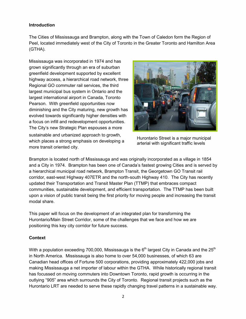
Hurontario Street is a major municipal arterial with significant traffic levels
Introduction
The Cities of Mississauga and Brampton, along with the Town of Caledon form the Region of
Peel, located immediately west of the City of Toronto in the Greater Toronto and Hamilton Area
(GTHA).
Mississauga was incorporated in 1974 and has
grown significantly through an era of suburban
greenfield development supported by excellent
highway access, a hierarchical road network, three
Regional GO commuter rail services, the third
largest municipal bus system in Ontario and the
largest international airport in Canada, Toronto
Pearson. With greenfield opportunities now
diminishing and the City maturing, new growth has
evolved towards significantly higher densities with
a focus on infill and redevelopment opportunities.
The City’s new Strategic Plan espouses a more
sustainable and urbanized approach to growth,
which places a strong emphasis on developing a
more transit oriented city.
Brampton is located north of Mississauga and was originally incorporated as a village in 1854
and a City in 1974. Brampton has been one of Canada’s fastest growing Cities and is served by
a hierarchical municipal road network, Brampton Transit, the Georgetown GO Transit rail
corridor, east-west Highway 407ETR and the north-south Highway 410. The City has recently
updated their Transportation and Transit Master Plan (TTMP) that embraces compact
communities, sustainable development, and efficient transportation. The TTMP has been built
upon a vision of public transit being the first priority for moving people and increasing the transit
modal share.
This paper will focus on the development of an integrated plan for transforming the
Hurontario/Main Street Corridor, some of the challenges that we face and how we are
positioning this key city corridor for future success.
Context
With a population exceeding 700,000, Mississauga is the 6th largest City in Canada and the 25th
in North America. Mississauga is also home to over 54,000 businesses, of which 63 are
Canadian head offices of Fortune 500 corporations, providing approximately 422,000 jobs and
making Mississauga a net importer of labour within the GTHA. While historically regional transit
has focussed on moving commuters into Downtown Toronto, rapid growth is occurring in the
outlying “905” area which surrounds the City of Toronto. Regional transit projects such as the
Hurontario LRT are needed to serve these rapidly changing travel patterns in a sustainable way.

3
Just to the north of Mississauga is the City of Brampton, the 10th largest City in Canada with a
population in excess of 500,000 residents. A municipality still expanding rapidly through
greenfield opportunities, while being anchored on a significant and historic urban core.
Brampton is also moving forward with new rapid transit initiatives such as their new Züm
program, which will introduce BRT type services along key corridors, including the Hurontario
corridor or Main Street as it is called in Brampton.
In 2006, the Province of Ontario released “Places to Grow”, a growth plan that outlined their
policies for shaping growth and planning for new infrastructure in the GTHA. The underlying
philosophy is directed towards intensification of existing built up areas and maximizing the use
of existing infrastructure. The plan identifies Downtown Brampton and Downtown Mississauga
as Urban Growth Centres and the focal point for intensification and growth. Furthermore, the
Hurontario/Main Street corridor connecting these centres was identified as a Higher Order
Transit Corridor and several mobility hubs with major transit station areas located at the
interchange of rapid transit corridors are identified along the length of the Hurontario/Main Street
corridor. Places to Grow also identifies that “public transit will be the first priority for
transportation infrastructure planning and major transportation investments” and provides further
criteria for planning and investment decisions.
Metrolinx, an entity of the Province was created to coordinate regional transportation planning
and developed “The Big Move” Regional Transportation Plan in 2008. The Big Move identified
the Hurontario/Main Street corridor from Port Credit in Mississauga to Downtown Brampton as
one of their top fifteen priority projects. In 2010, Metrolinx also completed the Hurontario/Main
Street Rapid Transit Benefits Case, which made the case for supporting the introduction of light
rail transit technology in the corridor and for proceeding with further planning, design and
engineering work.
Hurontario Street facing south from Downtown Mississauga
4
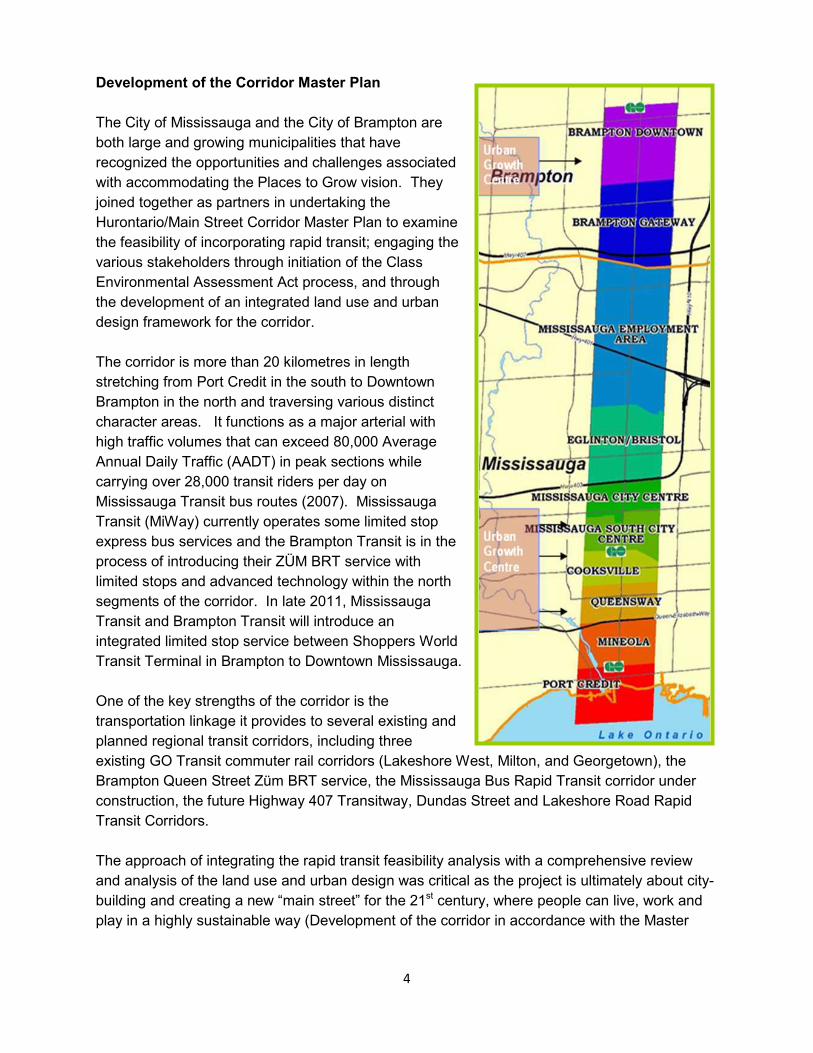
Development of the Corridor Master Plan
The City of Mississauga and the City of Brampton are
both large and growing municipalities that have
recognized the opportunities and challenges associated
with accommodating the Places to Grow vision. They
joined together as partners in undertaking the
Hurontario/Main Street Corridor Master Plan to examine
the feasibility of incorporating rapid transit; engaging the
various stakeholders through initiation of the Class
Environmental Assessment Act process, and through
the development of an integrated land use and urban
design framework for the corridor.
The corridor is more than 20 kilometres in length
stretching from Port Credit in the south to Downtown
Brampton in the north and traversing various distinct
character areas. It functions as a major arterial with
high traffic volumes that can exceed 80,000 Average
Annual Daily Traffic (AADT) in peak sections while
carrying over 28,000 transit riders per day on
Mississauga Transit bus routes (2007). Mississauga
Transit (MiWay) currently operates some limited stop
express bus services and the Brampton Transit is in the
process of introducing their ZÜM BRT service with
limited stops and advanced technology within the north
segments of the corridor. In late 2011, Mississauga
Transit and Brampton Transit will introduce an
integrated limited stop service between Shoppers World
Transit Terminal in Brampton to Downtown Mississauga.
One of the key strengths of the corridor is the
transportation linkage it provides to several existing and
planned regional transit corridors, including three
existing GO Transit commuter rail corridors (Lakeshore West, Milton, and Georgetown), the
Brampton Queen Street Züm BRT service, the Mississauga Bus Rapid Transit corridor under
construction, the future Highway 407 Transitway, Dundas Street and Lakeshore Road Rapid
Transit Corridors.
The approach of integrating the rapid transit feasibility analysis with a comprehensive review
and analysis of the land use and urban design was critical as the project is ultimately about city-
building and creating a new “main street” for the 21st century, where people can live, work and
play in a highly sustainable way (Development of the corridor in accordance with the Master

5
Plan will help the municipalities enhance mobility options, economic viability and quality of life in
order to become more socially, environmentally and economically sustainable and competitive).
One of the big challenges was to meld together the aspirations of various staff and stakeholders
from both municipalities. This was achieved through the establishment of a strong multi-
jurisdictional and inter-disciplinary project team, directing the work of a multi-disciplinary
consulting team and the use of an extensive public engagement process which included: public
information centres; community workshops; community television; presentations and displays at
a range of public events, stakeholders circulations and project newsletters that went out to over
40,000 addresses along the corridor and were also available in various other locations. The
project also reached out to stakeholders through electronic media such as the web site
(www.hurontario-main.ca), emails and Facebook. A business /developer symposium was also
held to target the perspective of these critical stakeholders whose input and support was critical
to the success of this project. The first Phase in the project culminated in a Directions Report that defined a vision for the corridor that would:
• Provide easy, reliable, frequent, comfortable and convenient rapid transit service throughout the corridor, with effective connections to other links in the inter-regional transit network;
• Create a beautiful street, with attractive “places” along the corridor featuring expanded mobility, vibrant economic activity, and livable, connected, mixed-use neighbourhoods, integrated with the transportation infrastructure; and
• Recognize and reinforce the Regional Urban System and the planned urban structure of
each City, and accordingly, encourage mixed-use, compact, intensified Transit Oriented Development directed along the corridor, customized to suit the varying and distinct nature of each existing community and sensitive to the presence of adjacent stable neighbourhoods.
A set of guiding principles was developed for the Master Plan to focus the development of a sustainable transportation solution for the corridor that included the following principles:
• Maintain the focus on the “big picture”;
• Make it sustainable and integrated; • Support transit through built form and
densities; • Put pedestrians first; • Plan for development that is compact
and complete; • Facilitate multimodalism; • Create connectivity; • Focus on place-making; • Ensure the plan is both visionary and
attainable; and • Protect stable neighbourhoods.
6
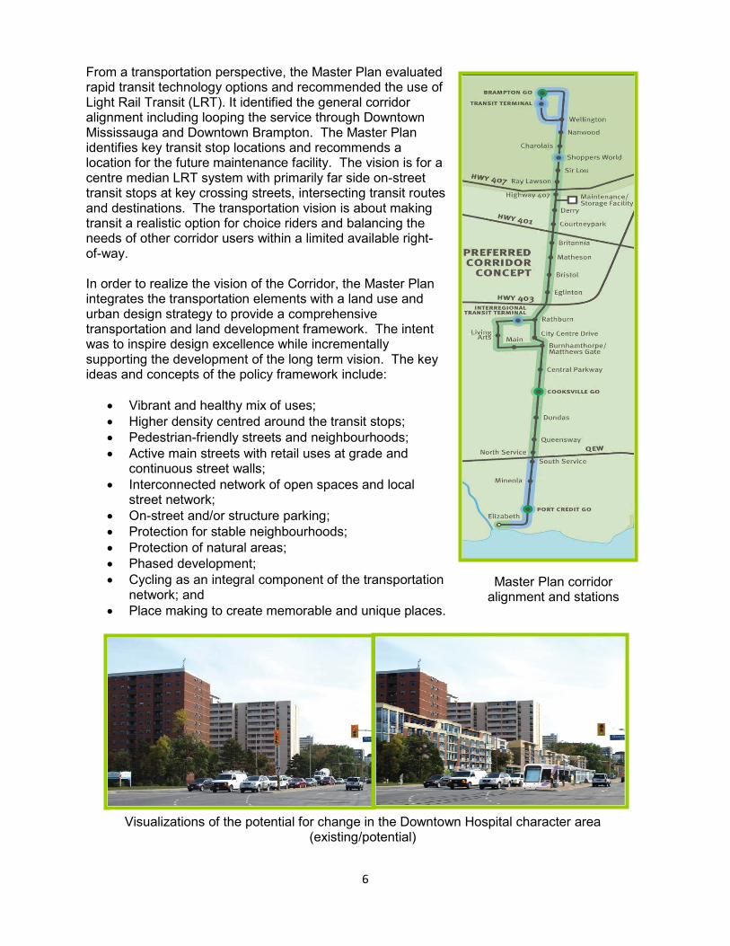
From a transportation perspective, the Master Plan evaluated rapid transit technology options and recommended the use of Light Rail Transit (LRT). It identified the general corridor alignment including looping the service through Downtown Mississauga and Downtown Brampton. The Master Plan identifies key transit stop locations and recommends a location for the future maintenance facility. The vision is for a centre median LRT system with primarily far side on-street transit stops at key crossing streets, intersecting transit routes and destinations. The transportation vision is about making transit a realistic option for choice riders and balancing the needs of other corridor users within a limited available right-of-way. In order to realize the vision of the Corridor, the Master Plan integrates the transportation elements with a land use and urban design strategy to provide a comprehensive transportation and land development framework. The intent was to inspire design excellence while incrementally supporting the development of the long term vision. The key ideas and concepts of the policy framework include:
• Vibrant and healthy mix of uses; • Higher density centred around the transit stops; • Pedestrian-friendly streets and neighbourhoods; • Active main streets with retail uses at grade and
continuous street walls; • Interconnected network of open spaces and local
street network; • On-street and/or structure parking; • Protection for stable neighbourhoods; • Protection of natural areas; • Phased development; • Cycling as an integral component of the transportation
network; and • Place making to create memorable and unique places.
Visualizations of the potential for change in the Downtown Hospital character area (existing/potential)
Master Plan corridor alignment and stations

7
The Master Plan applied the overall corridor strategies to the various unique character areas that form this corridor, with recommendations regarding permitted uses; densities, heights; street frontage; network connections; setbacks; public spaces; transitions and place-making.
Further detailed proof of concept sites were then used to test the impact of the proposed policies.
Master Plan Challenges During the course of the Master Plan development, numerous challenges needed to be overcome. It may be beneficial to discuss and share some of the key challenges identified. The stakeholder engagement process went beyond regulatory requirements for Environmental Assessment in order to build a true community/stakeholder vision and promote wide-spread support for this showcase project. In order to accommodate more development along this
Variation in Maximum Building Heights
Proof of Concept site (existing/potential)

8
already busy corridor, it was necessary to carefully communicate the key message that we need to shift our focus from moving vehicles to moving people. This is a difficult message to deliver in communities which depend so heavily upon automobiles, and where transit is often not seen as an attractive alternative to the car.
Another key challenge is building support for the project in the absence of a firm funding commitment. A symposium was held as part of the engagement process in an effort to target developers and significant land owners who play a major role in shaping the corridor today. Accommodating the competing interests for space within a limited right-of-way was yet another challenge. This is fuelled by growing community pressure for “complete streets”.
One of the biggest remaining challenges is to obtain public/stakeholder acceptance for the replacement of two of the six existing general purpose lanes for LRT along most of the corridor. Newer cities such as Mississauga and Brampton are still growing in terms of the level of community participation – there are areas along the corridor with well established and active community organizations or stakeholder groups, while others have little organized presence. This requires innovative forms of outreach. In addition to the methods noted above, the team also developed a Facebook page and pursued other aspects of social media.
Developing the Master Plan involved working with residents, developers, staff, and many other stakeholders to craft a vision for the ultimate transformation of the corridor. There are a variety of land uses and interests along the corridor, including stable low density residential communities with limited mixed use (Mineola), significant employment hubs with no permitted residential due to airport noise restrictions (Mississauga Employment Area), mixed use
9
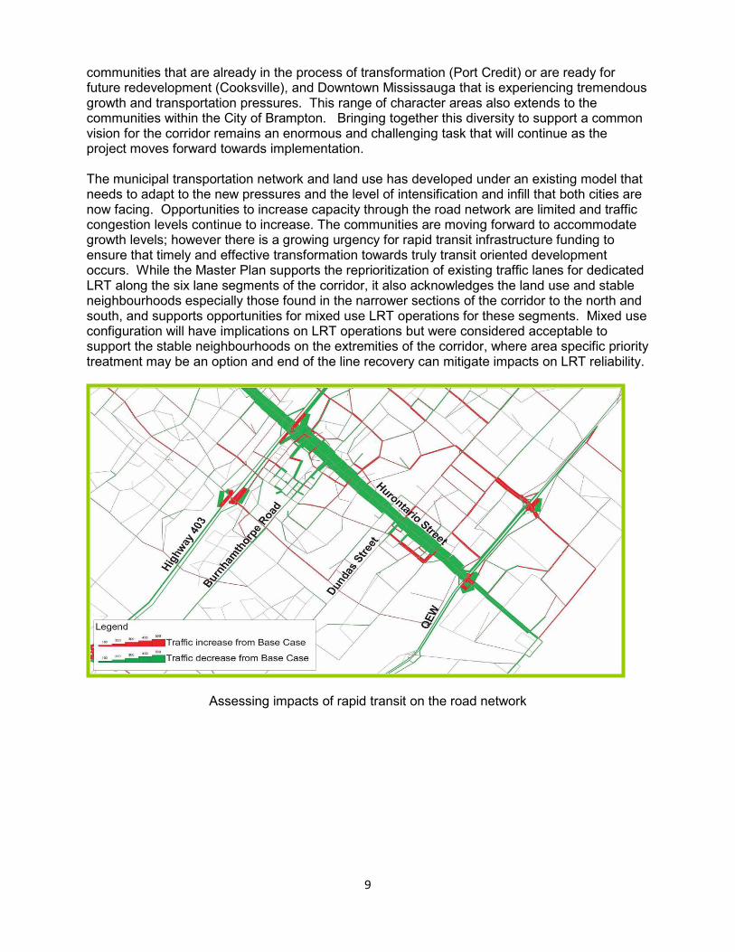
communities that are already in the process of transformation (Port Credit) or are ready for future redevelopment (Cooksville), and Downtown Mississauga that is experiencing tremendous growth and transportation pressures. This range of character areas also extends to the communities within the City of Brampton. Bringing together this diversity to support a common vision for the corridor remains an enormous and challenging task that will continue as the project moves forward towards implementation. The municipal transportation network and land use has developed under an existing model that needs to adapt to the new pressures and the level of intensification and infill that both cities are now facing. Opportunities to increase capacity through the road network are limited and traffic congestion levels continue to increase. The communities are moving forward to accommodate growth levels; however there is a growing urgency for rapid transit infrastructure funding to ensure that timely and effective transformation towards truly transit oriented development occurs. While the Master Plan supports the reprioritization of existing traffic lanes for dedicated LRT along the six lane segments of the corridor, it also acknowledges the land use and stable neighbourhoods especially those found in the narrower sections of the corridor to the north and south, and supports opportunities for mixed use LRT operations for these segments. Mixed use configuration will have implications on LRT operations but were considered acceptable to support the stable neighbourhoods on the extremities of the corridor, where area specific priority treatment may be an option and end of the line recovery can mitigate impacts on LRT reliability.
Assessing impacts of rapid transit on the road network

10
Next Steps The Hurontario/Main Street Master Plan represents a fundamental building block for achieving the respective municipal visions, which include placing a greater emphasis on transit to accommodate mobility needs and developing more transit oriented communities. Both municipalities plan to move forward on initiating required Official Plan and Zoning By-law reviews bases on the framework provided by the Master Plan. Mississauga and Brampton also plan to continue working in cooperation as the next phase of the Hurontario/Main Street Project commences, which is intended to complete preliminary design for LRT and obtain necessary Environmental Assessment approvals. This paper has been based upon the efforts and work of the combined Hurontario/Main Street Corridor Master Plan project team and the consultant consortium led by MMM Group (LRT graphics prepared by VIA Architects).


![Quantification of Recycled Concrete Aggregate (RCA ...conf.tac-atc.ca/english/annualconference/tac2011/docs/p3/butler.pdf · al. [9] from ASTM standard C 88-05, and ASTM standard](https://static.fdocuments.in/doc/165x107/5eb7628967f1d5547e6fd557/quantification-of-recycled-concrete-aggregate-rca-conftac-atccaenglishannualconferencetac2011docsp3.jpg)