Huron River Watershed Council: Green Infrastructure in Northfield Township
50
Northfield’s Green Infrastructure Northfield’s Landscape Trends What is Green Infrastructure? Visioning
-
Upload
jgnelson -
Category
Government & Nonprofit
-
view
235 -
download
0
Transcript of Huron River Watershed Council: Green Infrastructure in Northfield Township

Northfield’sGreen Infrastructure
Northfield’s Landscape
Trends
What is Green Infrastructure?
Visioning

HRWC is
Michigan’s first and
oldest watershed
council ~ a coalition
of local communities
and residents
established under state
law in 1965 to protect
the Huron River and
its tributary streams,
lakes, wetlands and
groundwater.
Stockbridge

The Huron River Watershed Green Infrastructure Services
Funding provided from the Americana Foundation

Northfield’s
Natural Assets

Landscape
Mostly undeveloped
31% intact natural areas (“bioreservesites”)
Only 5 % of natural areas publicly owned)
Low impervious surface (5%)
Woodland
Wetlands
Slopes over 12%
Hydric soils
Floodplains/Riparian area Endangered/threatened:
^ Animal
o Community
# Other
G Plant

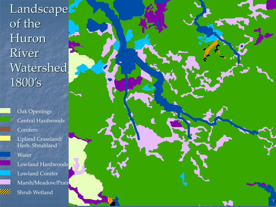
Conifers
Central Hardwoods
Lowland Conifer
Lowland Hardwoods
Marsh/Meadow/Prairie
Shrub Wetland
Oak Openings
Upland Grassland/Herb. Shrubland
Water
Landscape of the Huron River Watershed, 1800’s
Ann
Arbor
Detroit
Milford
Chelsea
Brighton
Northfield
Conifers
Central Hardwoods
Lowland Conifer
Lowland Hardwoods
Marsh/Meadow/Prairie
Shrub Wetland
Oak Openings
Upland Grassland/Herb. Shrubland
Water
Landscape of the Huron River Watershed, 1800’s

Oak/hickory forest
Photos: Ann Arbor NAP

Oak savannah/barren/tallgrass praire
Photos: Ann Arbor NAP
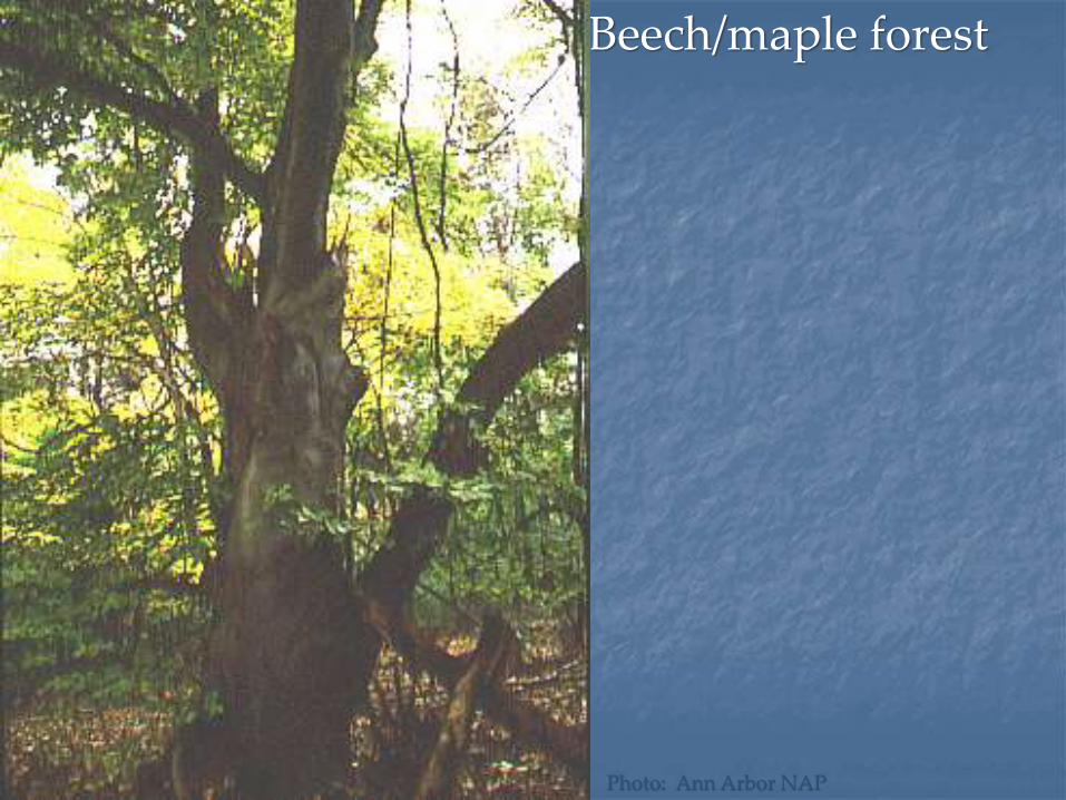
Beech/maple forest
Photo: Ann Arbor NAP

Lowland hardwood forest
Tamarack swamp
Ann Arbor NAP
Joshua G. Cohen

Inland wet prairie
Photo: Ann Arbor NAP

Marsh/wetland
Photo: Ann Arbor NAP

Massasauga
White lady slipper
Threatened, Endangered, Special Concern:9 animals16 plants1 ecosystem: Oak barrensHeron rookery
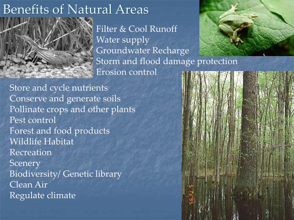
Benefits of Natural Areas
Store and cycle nutrientsConserve and generate soilsPollinate crops and other plantsPest control Forest and food productsWildlife HabitatRecreationScenery Biodiversity/ Genetic libraryClean AirRegulate climate
Photos: Ann Arbor NAP
Filter & Cool RunoffWater supplyGroundwater RechargeStorm and flood damage protectionErosion control

$1.8 billion/year in West Michigan

Little runoff prior to development
Water infiltrates
into humus and
porous soil
Plants take up
much water


Most rain flows THROUGH the
ground.
Few plants,
Hard surfaces
Plants intercept
the rain
Pre-Development Post-Development
Most rain flows OVER the
ground.
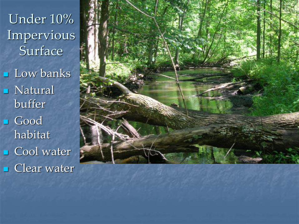
Under 10% Impervious
Surface
Low banks
Natural buffer
Good habitat
Cool water
Clear water

Between 10 and 25% Impervious Surface
Higher, undercut banks
sediment
Less diverse habitat
Warmer water

Over 25% Impervious Surface
Steep, eroded banks
Little buffer
Very little habitat
Warm water
flashy

Trends

Conifers
Central Hardwoods
Lowland Conifer
Lowland Hardwoods
Marsh/Meadow/Prairie
Shrub Wetland
Oak Openings
Upland Grassland/Herb. Shrubland
Water
Landscape of the Huron River Watershed, 1800’s

Landscape of the Huron River Watershed, 2000
Public
Grass/shrub
Woodland
Water
Wetlands

Natural area trends in the Huron
Fragmentation
Loss of wetlands (about 50%)
Loss of oak barrens, prairies, wooded wetlands, tamarack swamp

Future Trends
•40% of the remaining open space is projected to be developed in the next 20 years
•Master Plans and Zoning Ordinance build outs show little designated natural area
•Almost all natural areas in private ownership and designated for some kind of use
•Current development patterns are low density = more natural area converted per new person


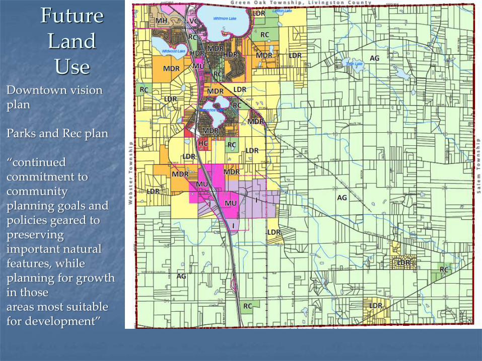
FutureLandUse
Downtown vision plan
Parks and Rec plan
“continued commitment to community planning goals and policies geared topreserving important natural features, while planning for growth in thoseareas most suitable for development”

Keeping Northfield Healthy

HRWC Key Message
To maintain the Huron River watershed’s health:
I. Encourage higher density where infrastructure already exists.
II. Preserve natural areas so they can continue to provide the ecological services necessary to maintain quality of water, air, land, and life.

The Huron River Watershed Bioreserve Project
To assess & protect the watershed’s last remaining natural areas
Funding provided by the Americana and Carlsfoundations

FLEM IN G R D.
ISLAND LAKE RD.
WY
LIE
RD
.
Bioreserve Map: based on aerials

Ranked Bioreserve Sites15 criteria
Total size Size of core Topographic diversity Geological diversity Waterway Upland/wetland Remnant plant community Groundwater recharge Connectivity Corridors Restorability Amount of change since 1800 Fragmentation MNFI “bio-rarity” index MNFI “special” communities

Field Assessment Assessing ecological integrity
Ground Truth GIS map
Get more information about the natural area
Help Conservancies protect most important lands
Help with stewardship of natural lands

248
530
209
207
260
261
249
436
195
192
435
252
205
202
196
189
266
206
208
188
264
268
191
265
256
255
197200
262
187
263
198
210
193254
250
204
427
190
211
259
430
211
253
203
258
257
199
201
194
251
221
267
153
152
216
483
152
219
176
219
173
Joy
Dix
bo
ro
No
llar
Su
tton
7 Mile
Ea
rha
rt
5 Mile
6 Mile
Ma
in
Pontiac
Sp
en
ce
r
North Territorial
Helln
er
Ma
ple
Kea
rne
y
Ru
sh
ton
Barker Jen
nin
gs
Shore
Northfield Church
Coyl
e
Nix
on
Wh
itm
ore
La
ke
Gle
an
er H
all
Joy
6 Mile
Ea
rha
rtE
arh
art
5 Mile
Ma
ple
5 Mile
Northfield’s remaining
natural areas
Field Assessments in Northfield
Doing assessments this summer

What you can do
•Design higher density, livable neighborhoods•Live in a walkable community•Plant trees, native plants in your lawn•Keep water on your land•Control stormwater runoff•Leave natural buffers around creeks, wetlands, and ponds
•Keep natural lands natural
•Permanently preserve larger, intact, natural lands
•Join us in assessing the creek and its landscapes

Green infrastructure is the interconnected network of open spaces, natural areas and waterways
Focusing on conservation values and the services provided by natural systems in concert with, instead of in opposition to, land development
Gives us an opportunity to Identify, Protect & Enhance our Natural Assets
What is Green Infrastructure?
Natural
Built

Green infrastructure networks consist of the following components:
Hubs: Hubs anchor the network and provide an origin or destination for wildlife.
Sites: Smaller ecological landscape features that can serve as a point of origin or destination
Links: The connections that holdthe network together and enable itto function. Links facilitate movementfrom one hub to another.
Hub
Hub
Link
Sites
GI Background

Network Anchor(Hub) LargeNatural Area/Park
Network Anchor(Hub) LargeNatural Area/park
Network Anchor(Hub) LargeNatural Area/park
Small Forested
Area (site)
Small Wetland Area (site)
Small Natural Area (site)
Tree Rows (Link)
Fence &Hedge Rows (Link)
River or Stream (Link)

HRWC


Example
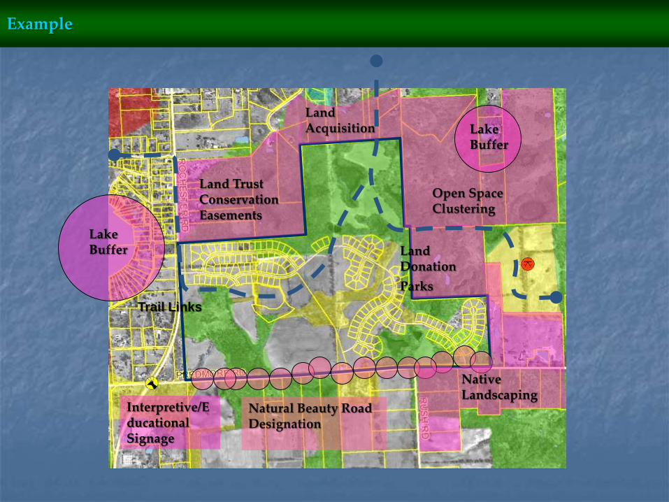
Land TrustConservation Easements
Natural Beauty Road Designation
Interpretive/Educational Signage
Open Space Clustering
Native Landscaping
Land Donation
Parks
Land Acquisition Lake
Buffer
Lake Buffer
Trail Links
Example

In urban environments, green infrastructure includes green roofs, trees, rain gardens, vegetated swales, pocket wetlands, parks, riparian buffers, no-mow zones, floodplains and strategically placed forested areas.
Green Roof
Riparian Buffers
Rain Garden
Vegetated Swales
Pocket Wetlands
Floodplains
Riparian BuffersParks
Wild Corners Program
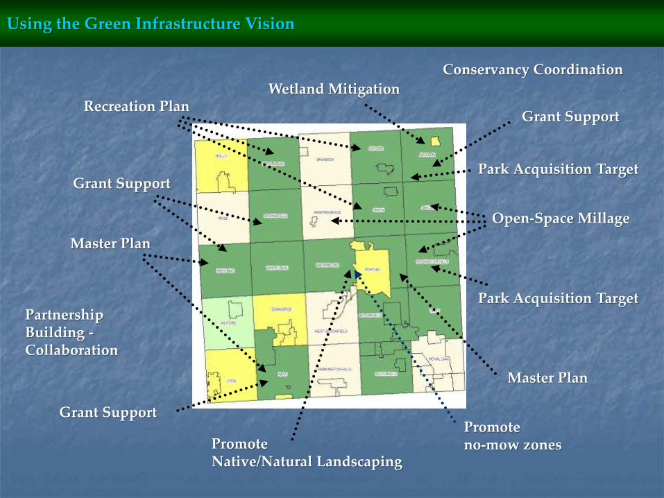
Open-Space Millage
Park Acquisition Target
Park Acquisition Target
Promote Native/Natural Landscaping
Conservancy Coordination
Grant Support
Grant Support
Master Plan
Wetland MitigationRecreation Plan
Master Plan
Grant Support
Partnership Building -Collaboration
Promoteno-mow zones
Using the Green Infrastructure Vision