Human activity and damaging landslides and floods on … · and to determine whether a...
12
Nat. Hazards Earth Syst. Sci., 11, 3035–3046, 2011 www.nat-hazards-earth-syst-sci.net/11/3035/2011/ doi:10.5194/nhess-11-3035-2011 © Author(s) 2011. CC Attribution 3.0 License. Natural Hazards and Earth System Sciences Human activity and damaging landslides and floods on Madeira Island D. Baioni Dipartimento di Scienze della Terra, Universit` a degli studi di Parma, Campus Universitario, Via delle Scienze 43100 Parma (PR), Italy Received: 3 August 2011 – Accepted: 26 September 2011 – Published: 15 November 2011 Abstract. Over the last few decades, the island of Madeira has become an important offshore tourism and business cen- ter, with rapid economic and demographic development that has caused changes to the landscape due to human activity. In Madeira’s recent history, there has been an increase over time in the frequency of occurrence of damaging landslide and flood events. As a result, the costs of restoration work due to damage caused by landslide and flood events have become a larger and larger component of Madeira’s annual budget. Landslides and floods in Madeira deserve particular attention because they represent the most serious hazard to human life, to property, and to the natural environment and its important heritage value. The work reported on in this paper involved the analysis of historical data regarding damaging landslide and flood events on Madeira (in particular from 1941 to 1991) together with data on geological characteristics, topographic features, and climate, and from field observations. This analysis showed that the main factor triggering the occurrence of damaging landslide and flood events is rainfall, but that the increase in the number of damaging events recorded on Madeira Is- land, especially in recent times, seems to be related mostly to human activity, specifically to economic development and population growth, rather than to natural factors. 1 Introduction The island of Madeira is part of an archipelago of vol- canic origin situated in the Atlantic Ocean (from 32 ◦ 23 N to 33 ◦ 07 N and from 16 ◦ 15 W to 17 ◦ 15 W) approximately 900 km southwest of Portugal and 700 km west of the coast Correspondence to: D. Baioni ([email protected]) of Morocco (Fig. 1). Madeira is the main island of the group, measuring 58 km in length and having a maximum width of 23 km, with a surface area of 739 km 2 . The island of Madeira is part of Portugal, but it is an au- tonomous region with its own government that can freely dis- cuss and regulate many matters regarding its own territory. Madeira has a resident population of approximately 245 000 concentrated almost exclusively in the coastal areas, predominantly on the south side of the island where most of the larger towns are located and where most of the economic activity of Madeira takes place. The southeastern part of the island, in particular the coastal strip between the capital, Funchal, and the city of Machico, is very densely populated. Funchal is currently one of the most densely populated ar- eas in the entire European Community (1338 inhabitants per km 2 ), with an annual growth rate of 4 %, which is rapidly increasing. Human activity on the island of Madeira dates back to the end of the fifteenth century, when the first pioneers began to settle there, cultivating sugar cane and building the first village, Funchal, which would later become the capital city. Up to the end of the nineteenth century, Madeira did not have a port and was not known as a tourist destination. Building construction that interfered with the natural envi- ronment of Madeira began during the twentieth century when its main port (Funchal) became an essential supply station for ships en route to Africa and South America. The strate- gic and commercial importance of becoming an essential stopover point for maritime traffic encouraged residents to build artificial canals called “levadas”, which are still present today, to divert natural water flows from the north side of the island, which is much rainier and not very built up, to the southern part of the island, which is undergoing constant expansion. The growth in human activity on Madeira began during the nineteenth century but intensified only during the second half of the twentieth century. Published by Copernicus Publications on behalf of the European Geosciences Union.
Transcript of Human activity and damaging landslides and floods on … · and to determine whether a...

Nat. Hazards Earth Syst. Sci., 11, 3035–3046, 2011www.nat-hazards-earth-syst-sci.net/11/3035/2011/doi:10.5194/nhess-11-3035-2011© Author(s) 2011. CC Attribution 3.0 License.
Natural Hazardsand Earth
System Sciences
Human activity and damaging landslides and floods onMadeira Island
D. Baioni
Dipartimento di Scienze della Terra, Universita degli studi di Parma, Campus Universitario, Via delle Scienze43100 Parma (PR), Italy
Received: 3 August 2011 – Accepted: 26 September 2011 – Published: 15 November 2011
Abstract. Over the last few decades, the island of Madeirahas become an important offshore tourism and business cen-ter, with rapid economic and demographic development thathas caused changes to the landscape due to human activity.In Madeira’s recent history, there has been an increase overtime in the frequency of occurrence of damaging landslideand flood events. As a result, the costs of restoration workdue to damage caused by landslide and flood events havebecome a larger and larger component of Madeira’s annualbudget. Landslides and floods in Madeira deserve particularattention because they represent the most serious hazard tohuman life, to property, and to the natural environment andits important heritage value.
The work reported on in this paper involved the analysis ofhistorical data regarding damaging landslide and flood eventson Madeira (in particular from 1941 to 1991) together withdata on geological characteristics, topographic features, andclimate, and from field observations. This analysis showedthat the main factor triggering the occurrence of damaginglandslide and flood events is rainfall, but that the increasein the number of damaging events recorded on Madeira Is-land, especially in recent times, seems to be related mostlyto human activity, specifically to economic development andpopulation growth, rather than to natural factors.
1 Introduction
The island of Madeira is part of an archipelago of vol-canic origin situated in the Atlantic Ocean (from 32◦23′Nto 33◦07′N and from 16◦15′W to 17◦15′W) approximately900 km southwest of Portugal and 700 km west of the coast
Correspondence to:D. Baioni([email protected])
of Morocco (Fig. 1). Madeira is the main island of the group,measuring 58 km in length and having a maximum width of23 km, with a surface area of 739 km2.
The island of Madeira is part of Portugal, but it is an au-tonomous region with its own government that can freely dis-cuss and regulate many matters regarding its own territory.
Madeira has a resident population of approximately245 000 concentrated almost exclusively in the coastal areas,predominantly on the south side of the island where most ofthe larger towns are located and where most of the economicactivity of Madeira takes place. The southeastern part ofthe island, in particular the coastal strip between the capital,Funchal, and the city of Machico, is very densely populated.Funchal is currently one of the most densely populated ar-eas in the entire European Community (1338 inhabitants perkm2), with an annual growth rate of 4 %, which is rapidlyincreasing.
Human activity on the island of Madeira dates back to theend of the fifteenth century, when the first pioneers beganto settle there, cultivating sugar cane and building the firstvillage, Funchal, which would later become the capital city.Up to the end of the nineteenth century, Madeira did not havea port and was not known as a tourist destination.
Building construction that interfered with the natural envi-ronment of Madeira began during the twentieth century whenits main port (Funchal) became an essential supply stationfor ships en route to Africa and South America. The strate-gic and commercial importance of becoming an essentialstopover point for maritime traffic encouraged residents tobuild artificial canals called “levadas”, which are still presenttoday, to divert natural water flows from the north side ofthe island, which is much rainier and not very built up, tothe southern part of the island, which is undergoing constantexpansion. The growth in human activity on Madeira beganduring the nineteenth century but intensified only during thesecond half of the twentieth century.
Published by Copernicus Publications on behalf of the European Geosciences Union.

3036 D. Baioni: Human activity and damaging landslides and floods on Madeira Island
24
542
Figure 1. Location map of Madeira Archipelago. 543
544
Figure 2. Geology of Madeira Island (after Zbyszewski et al., 1975). (B1) 545
basaltic pyroclasts; (B2) explosive and effusive material; (B3) pyroclastic 546
materials; (B4) thick basaltic flow; (B5) last volcanic stage. 547
Fig. 1. Location map of Madeira Archipelago.
In the last few decades, Madeira has become an importanttourist destination, which has led to an explosion of buildingactivity in a very short space of time, involving both hotelsand their associated infrastructure. The scarcity of suitablespace for building due to the topography of the island hastended to force development into unsuitable areas, causingprofound changes to the landscape.
Over the last few decades, Madeira has seen rapid eco-nomic growth.
Madeira’s recent history shows a clear increase in the costof restoration work, protective measures, and damage causedby landslides and floods, costs that have become a larger andlarger component of Madeira’s annual budget.
On Madeira, natural geomorphological processes are par-ticularly active due to the island’s geographical location andclimatic characteristics.
The aim of this study is to explore the relationship betweenthe occurrence of damaging landslides and floods on Madeiraand the intensity of recent human activity and development,and to determine whether a cause-effect relationship may ex-ist.
2 Study area
2.1 Geology and geomorphology
Madeira Island was formed by volcanic activity in theMiocene period; its geology is illustrated in Fig. 2 (afterZbyszewski et al., 1975). The formation of Madeira beganin the Middle Miocene with explosive submarine eruptionsconsisting mainly of basaltic pyroclasts (B1 complex). Aftera very long pause, further volcanic activity formed an exten-sive complex made up of explosive and effusive material (B2complex). After another interruption, renewed volcanic ac-tivity formed a basaltic complex where flows dominate overpyroclastic materials (B3 complex). The B3 complex wasthen successively overlaid by thick basaltic flows attributedto fissural volcanism (B4 complex); during the last volcanicstage, the eruptions filled existing valleys in the northwest-ern part of the island (B5 complex). The central region hasthe characteristic of a volcanic rift (Geldmacher and Hoernle,2000) with swarms of vertical dikes, normal faults, grabenstructures, and cinder cones, all parallel to the E-W trendinglong axis of the island.
The island is mountainous, especially in the central part(Fig. 3), with altitudes that reach 1860 m a.s.l. The aver-age altitude is 700 m and 90 % of the island is over 500 m
Nat. Hazards Earth Syst. Sci., 11, 3035–3046, 2011 www.nat-hazards-earth-syst-sci.net/11/3035/2011/

D. Baioni: Human activity and damaging landslides and floods on Madeira Island 3037
24
542
Figure 1. Location map of Madeira Archipelago. 543
544
Figure 2. Geology of Madeira Island (after Zbyszewski et al., 1975). (B1) 545
basaltic pyroclasts; (B2) explosive and effusive material; (B3) pyroclastic 546
materials; (B4) thick basaltic flow; (B5) last volcanic stage. 547
Fig. 2. Geology of Madeira Island (after Zbyszewski et al., 1975). (B1) basaltic pyroclasts; (B2) explosive and effusive material;(B3) pyroclastic materials; (B4) thick basaltic flow; (B5) last volcanic stage.
25
548
Figure 3. Topography of Madeira Island (equidistance 100 m.). 549
550
Figure 4. Average annual precipitation in Madeira Island (historical records 551
1961-1990). Image (modified) from Ministero do Ambiente e do ordenamento 552
do Territorio of Portugal website. 553
Fig. 3. Topography of Madeira Island (equidistance 100 m.) modified by Galopim de Carvalho and Brandao, 1991.
in altitude, rising up abruptly from the sea. Relief increasesin altitude from east to west, and the island’s highest pointis Pico Ruivo (1860 m). The areas above 1000 m representapproximately one-third of the entire area of the island (Ga-lopim de Carvalho and Brandao, 1991). The mountains act asan effective barrier between the north and south sides, givingthem completely different climatic characteristics and differ-ent exposures to erosive agents.
Climatic conditions are fundamental in explaining themorphological differences between the northern and south-ern flanks of the island, because these two environments havea marked difference in exposure to the dominant northerlyand northeasterly winds, to the consequent wave motion, andto rainfall.
According to many authors (Ribeiro, 1948; Michell-Thome, 1979; Wirthmann, 1970), the location of Madeira’smain water catchment divide, which does not coincide withthe median line of the island but lies further to the south, isproof of the rapid and more extensive erosion to which thenorth side is subjected. The interior valleys trend radiallyfrom the central mountain massif towards the coast influenc-ing the hydrographic network, which is heavily incised, withan exceptionally direct trend (Michell-Thome, 1976; Cza-jkoski, 2002). The accepted view is that these valleys arepurely erosional features, but according to some authors thestraightness of the valleys is an indication of structural influ-ences on their courses (Scheidegger, 2002).
www.nat-hazards-earth-syst-sci.net/11/3035/2011/ Nat. Hazards Earth Syst. Sci., 11, 3035–3046, 2011

3038 D. Baioni: Human activity and damaging landslides and floods on Madeira Island
The most active geomorphic processes are coastal erosion,runoff erosion, chemical weathering of pyroclastic rocks, andlandslide activity. The coast on the north side of the islandhas higher cliffs than the coast on the south side. Alongthe south coast, the slopes are more gentle and the cliffs aresometimes interrupted by beaches.
On this side of the island, intense human activity hascaused further changes to the landscape, which will be de-scribed later.
2.2 Climatic characteristics
The climate of Madeira is determined mainly by the sub-tropical Azores anticyclone. During the summer, masses oftropical air reach Madeira, while in the winter, when theAzores anticyclone returns to its usual, more southerly po-sition, Madeira is affected by the polar front from the NorthAtlantic. During the winter, between November and Febru-ary in particular, Madeira benefits from the formation of ananticyclonic area opposite Morocco that affects the island’sweather for a few weeks before dissipating (Caldera et al.,2002).
The topographical barrier formed by the main drainage di-vide in the center of the island creates a climatic differencebetween the southern and northern coasts, with much morepleasant conditions on the southern side (Caldera, 1996).
In general, Madeira’s climate is surprisingly humid andtemperate, considering its latitude, due to the effects of thesurrounding ocean (Dias et al., 1992).
The annual average temperature varies significantly bothwith altitude and between the southern and northern sides,with typical values between 17◦C and 19◦C, but descendingas low as 9◦C in the mountainous areas (Van der Weijden andPacheco, 2003).
The annual precipitation on Madeira (Fig. 4) varies from600–800 mm on the south coast to 1500–2000 mm on thenorth coast, reaching 3000 mm in the higher areas. The rain-falls are often violent with an intensity that can reach 500 mmin a single day (the maximum recorded is 522.3 mm), espe-cially in autumn and early spring when very high-intensityrainfalls occur within a very short time (sometimes no morethan three hours) and are often associated with strong windsand stormy seas.
3 Methodology of investigation
A detailed analysis of damaging landslides and floods wascarried out to determine their distribution in space and time,as well as possible variations in frequency and recent evolu-tionary trends.
For flood events, the data include frequency, geographicdistribution, and damage caused.
For mass movements, the data include the classification,mechanism, frequency, geographic distribution, and damagerecorded.
A georiskdatabase (Rodrigues and Ayala-Carcedo, 2000)contains records for approximately 700 events from 1611to the present, supplemented by additional data for the lastfew decades which were supplied by the regional institu-tions archive of Madeira. In the data as recorded, numerousattributes are often included for each individual event sur-veyed, such as the type of event, the location, the date, themeteorological conditions previous to the event, and the ef-fects on the population and on structures.
The information does not refer only to catastrophic eventsbut also includes events of lesser intensity, and when it iscomplete, it provides an excellent description of each indi-vidual event, particularly in the period from 1941 to 1991.
The database incorporates mainly the landslides and floodsthat have caused damage, and it allows the analysis of theevolution of the risk.
The usefulness of historical records in dating the occur-rence of ancient and recent landslide events has been demon-strated by many authors (Garland and Oliver, 1993; Bruns-den et al., 1995; Chandler and Brunsden, 1995; Ibsen andBrunsden, 1996), and many scientists all over the world haveused written accounts or proxy data for the analysis of haz-ardous flood events (Barnikel and Becht, 2003; Barriendoset al., 2002; Coeur et al., 1998; Stedinger and Cohn, 1986;Sutcliffe, 1987).
Analysis of evolutionary trends in landslide and floodevents and rainfall was carried out to verify whether climaticchange is the only or the main cause of the increasing fre-quency of damaging landslides and floods on Madeira, orwhether human factors have had a significant impact. Land-slides and floods almost always occur during or immediatelyafter intense rainfall, as is well documented from news andhistorical reports and the direct experience of the inhabitants.
After examination of the historical data on landslides andfloods and climatic data for the entire island, an area locatedto the south of the main drainage divide of the island extend-ing between Faja da Ovelha and Machico was selected fordetailed study, because here the lithology (Fig. 2), topogra-phy (Fig. 3), and pluviometry (Fig. 4) reveal an area withhighly uniform natural characteristics, which should enablethe isolation of human influences.
This area includes two distinct zones. In the southeast-ern part, located between Camara da Lobos and Machico (21drainage basins), human activity is intense. There are twomain cities (Funchal and Machico), four smaller cities (Ca-mara do Lobos, Canico, Santa Cruz, and Santa Catarina), andmost of the economic and human activities on the island arelocated here. In the other area, located between Camara daLobos and Faja da Ovelha (26 drainage basins), human ac-tivity is much less intense, and the only cities with increasinghuman activity are Ponta do Sol and Ribeira Brava.
Nat. Hazards Earth Syst. Sci., 11, 3035–3046, 2011 www.nat-hazards-earth-syst-sci.net/11/3035/2011/

D. Baioni: Human activity and damaging landslides and floods on Madeira Island 3039
25
548
Figure 3. Topography of Madeira Island (equidistance 100 m.). 549
550
Figure 4. Average annual precipitation in Madeira Island (historical records 551
1961-1990). Image (modified) from Ministero do Ambiente e do ordenamento 552
do Territorio of Portugal website. 553
Fig. 4. Average annual precipitation in Madeira Island (historical records 1961–1990). Image (modified) from Ministero do Ambiente e doordenamento do Territorio of Portugal website.
The final phase of this investigation involved documenta-tion of modifications introduced directly and indirectly as aresult of human activity that might encourage the occurrenceof landslides and floods.
4 Results
4.1 Analysis of historical data for damaging landslideand flood events
Historical data from 1611 to the present show clearly that thehazardous events that have had the greatest impact and thathave produced the worst damage are “flash floods”, followedby landslide events.
4.1.1 Extreme events
Considering extreme events (landslides and floods) that canbe characterized as natural disasters (Alcantara-Ayala, 2002;Blaikie et al., 1994), the data show that: (i) only one event isrecorded in the eighteenth century (a flash flood in Novem-ber 1724, with 26 deaths and 80 homes damaged in the city ofMachico); (ii) two events are recorded in the nineteenth cen-tury (a flash flood in 1803 with approximately 600 deaths, theworst calamity ever recorded in the history of Madeira, andanother flash flood in 1842 with one death and the destruc-tion of a large part of the city of Funchal); (iii) six eventsare recorded in the twentieth century (a flash flood in 1920with two deaths and 500 people left homeless; a debris flowin 1929 with 34 deaths; a flash flood in 1956 with six deaths;another flash flood and debris flow in 1979 with 14 deaths; aflash flood in 1993 with seven deaths and 47 injured; an earthflow in 1997 with 20 homes destroyed).
These data reveal that: (i) in the twentieth century, thenumber of the most serious catastrophic events and the costof the damages caused increased substantially with respect tothe two previous centuries; (ii) the twentieth century eventsare concentrated in the second half of that century (fourevents out of six occurred between 1956 and 1997); (iii) theinterval between events became shorter and shorter (higherfrequency of catastrophic events).
The new century does not appear to have changed thistrend. In fact, two extreme events have already beenrecorded.
On 5–6 March 2001 after intense rain, disastrous eventscaused the death of five people as well as damage amount-ing to 50 million USD. In the area of Rosario, two debrisflows damaged a main road, sweeping away a car containingfour tourists and killing them as well as damaging countlesshomes and a school; in the city of Curral, a debris flow oc-curred, submerging several homes. Because these events oc-curred during the day, sufficient time was available to raisethe alarm and to evacuate many people from the most danger-ous areas, thus avoiding a tragedy of even greater proportions(Rodrigues and Ayala-Carcedo, 2003).
On 20 February 2010, after heavy rain, a flash flood andmudslide occurred in Funchal where the streets were litteredwith debris and coated with mud. Some residents had to holdon to railings or any sturdy object they could find so theyweren’t swept away by the torrents. A number of cars werecaught by the force of the water, and the battered shells ofoverturned vehicles littered the streets. The disastrous eventscaused the death of forty-two people, more than 120 peoplewere injured, and displaced more than two hundred people.The damage amounted to about 1.4 billion of Euro.
www.nat-hazards-earth-syst-sci.net/11/3035/2011/ Nat. Hazards Earth Syst. Sci., 11, 3035–3046, 2011

3040 D. Baioni: Human activity and damaging landslides and floods on Madeira Island
4.1.2 Landslides
This investigation indicated that: (i) the landslides surveyedcould be classified as debris flows, mudflows, earth flows,or rock fall, using the Varnes classification (Varnes, 1978);(ii) landslide frequency increased (decreased interval be-tween recurrences) during the study period; (iii) between1941 and 1991, 596 landslides were recorded on the island;262 events occurred in the south sector (47 drainage basins,surface area of 314.01 km2, 0.834 landslides km2), and 334events occurred in the remaining northern sector (40 drainagebasins, surface area of 424.99 km2, 0.786 landslides km2);(iv) although the increase in observed frequency is quitewidespread, the data appear to indicate that the frequency ofoccurrence in the southeastern part of Madeira is above aver-age; (v) most events occur between the months of Novemberand April; (vi) rainfall is the main cause of the landslides.
4.1.3 Floods
The data reveal that: (i) flood events are mainly flash floods;(ii) there is an increase in frequency (decrease in the inter-val between events) over the study period; (iii) between 1941and 1991, a total of 56 damaging events were recorded inall 87 drainage basins of the island; 46 events occurred inthe sector to the south of the island’s main drainage divide,and only 10 events occurred in the sector to the north ofthe island’s main drainage divide; (iv) in the northern sector,events occurred in only three drainage basins, and 8 out of atotal of 10 events occurred in the drainage basins that are sub-jected to some human activity (four in the Sao Vicente basin,four in the Fajal basin); (v) in the southern sector, events oc-curred in 11 drainage basins, and 31 out of a total of 46 eventsoccurred in the southeastern sector; (vi) a completely differ-ent incidence frequency was observed for the events recordedin the two sectors separated by the island’s main drainage di-vide. This observation reveals a difference in susceptibilityto flooding, which arises from the climatic conditions and therainfall data for the two sides of Madeira Island.
4.1.4 Sector to the south of Madeira’s maindrainage divide
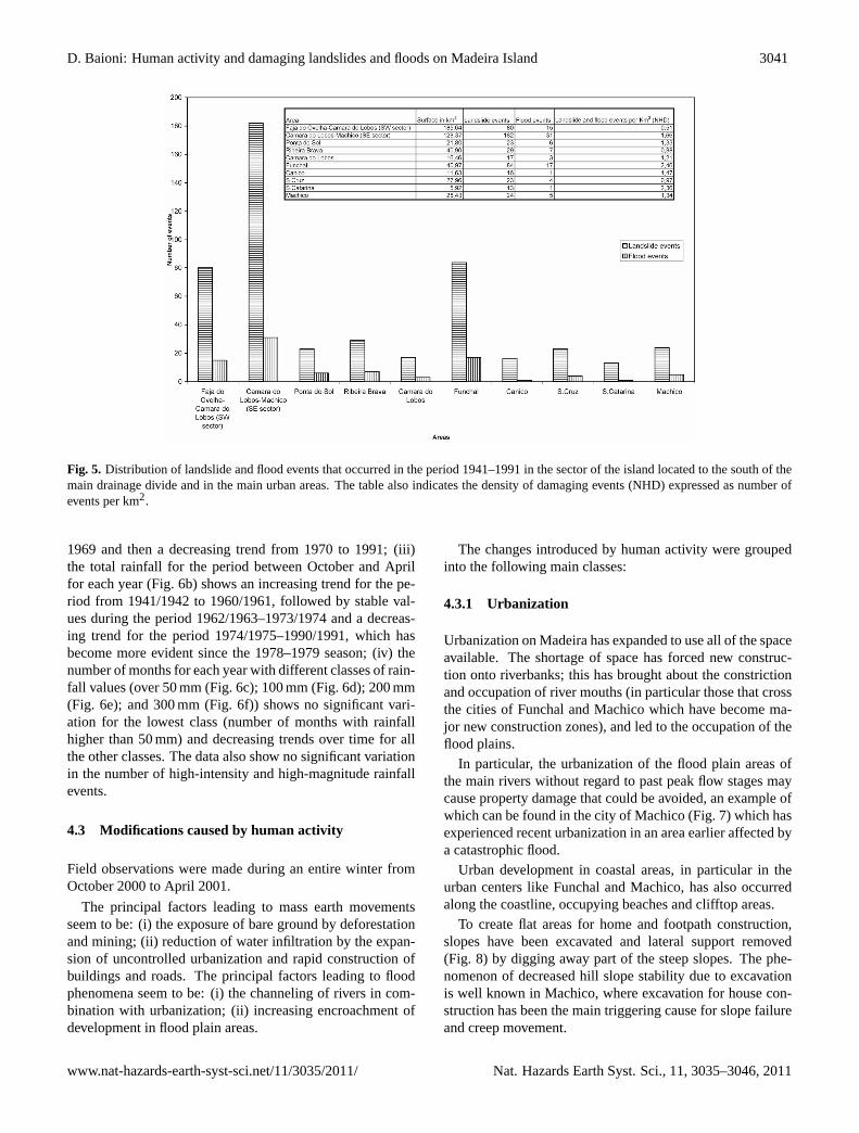
The data for landslide events that occurred between 1941and 1991 (illustrated in Fig. 5) reveal that: (i) 182 landslides(69.5 %) occurred in the southeastern sector between Camarada Lobos and Machico and 80 in the remaining southwesternsector; (ii) the areas with the highest number of landslidescorrespond to the drainage basins where the main urban cen-ters are located, that is, in the southeastern sector, the capital,Funchal (84 events), Santa Cruz (23 events), and Machico(24 events), and in the southwestern sector, Ponta do Sol (23events) and Ribeira Brava (29 events). The remaining partsof the territory, which are not so intensely affected by humanactivity, have much fewer landslide occurrences.
The data for floods that occurred between 1941 and 1991(Fig. 5) reveal that: (i) out of a total of 46 events recordedand located within 11 drainage basins, 31 (67.4 %) occurredin the southeastern area between Camara do Lobos andMachico, while 15 events occurred in the remainder of thesouthwestern sector; (ii) the areas with the most floods arethose drainage basins where the main urban centers are lo-cated, that is, in the southeastern sector, the capital, Funchal(17 events), Santa Cruz (4 events), and Machico (5 events),and in the southwestern sector, Ponta do Sol (6 events) andRibeira Brava (7 events).
The integrated analysis of landslide and flood data for thissector shows that: (i) there was a significant difference invalues between the southeastern and southwestern sectorsfor the total number of all hazardous events (landslides andfloods) and for event density (expressed as number of eventsper km2 and referred to below as the density of damagingevents, or NHD). In the southeastern area between Camarada Lobos and Machico, 213 events (72.7 %) were recorded,with an average NHD value of 1.66, as opposed to 95 eventsand an average NHD value of 0.51 for the southwestern areabetween Camara da Lobos and Faja da Ovelha; (ii) in thesoutheastern area, the highest values were recorded in the ar-eas of Machico (29 events with an NHD of 1.34), Santa Cata-rina (14 events with an NHD of 2.36), Santa Cruz (27 eventswith an NHD of 097), Canico (17 events with an NHD of1.47), Camara do Lobos (20 events with an NDE of 1.21),and in the area of the capital, Funchal, with the highest val-ues in the entire southern part of the island (101 events withan NHD of 2.46); (iii) in the southwestern area, the highestvalues were recorded in the areas of Ponta do Sol (29 eventswith an NHD of 1.33) and Ribeira Brava (36 events with anNHD of 0.88); (iv) the areas where human activity is great-est have a number of occurrences of damaging landslides andfloods that is 2.7 times higher than that of less-disturbed ar-eas, and a density of damaging events which is up to fourtimes higher.
4.2 Analysis of rainfall historical data
Recorded data for the twentieth century show that: (i) rainfallis concentrated in the period between October and April, dur-ing which time 90 % of the annual precipitation is recorded;(ii) annual rainfall has not been increasing over time; on thecontrary, rainfall has been decreasing progressively since thebeginning of the twentieth century; (ii) there are no signif-icant decadal oscillations in annual rainfall; (iii) there hasbeen no increase in the annual number of high-intensity andhigh-magnitude rainfall events.
Rainfall data from 1941 to 1991 recorded at the SantaCatarina station near the airport (Fig. 6) reveal that: (i) theaverage annual rainfall value is 681.4 mm, and the maximumvalue is 1236.0 mm (recorded in 1968), and the minimumvalue is 387.4 mm (recorded in 1947); (ii) the annual rain-fall (Fig. 6a) shows a modest increasing trend from 1941 to
Nat. Hazards Earth Syst. Sci., 11, 3035–3046, 2011 www.nat-hazards-earth-syst-sci.net/11/3035/2011/
D. Baioni: Human activity and damaging landslides and floods on Madeira Island 3041
26
554
Figure 5. Distribution of landslide and flood events occurred in the period 1941-555
1991 in the sector of the island located to the south of the main drainage divide 556
and in the main urban areas. The table also indicates the density of damaging 557
events expressed as number of events per km2. 558
Fig. 5. Distribution of landslide and flood events that occurred in the period 1941–1991 in the sector of the island located to the south of themain drainage divide and in the main urban areas. The table also indicates the density of damaging events (NHD) expressed as number ofevents per km2.
1969 and then a decreasing trend from 1970 to 1991; (iii)the total rainfall for the period between October and Aprilfor each year (Fig. 6b) shows an increasing trend for the pe-riod from 1941/1942 to 1960/1961, followed by stable val-ues during the period 1962/1963–1973/1974 and a decreas-ing trend for the period 1974/1975–1990/1991, which hasbecome more evident since the 1978–1979 season; (iv) thenumber of months for each year with different classes of rain-fall values (over 50 mm (Fig. 6c); 100 mm (Fig. 6d); 200 mm(Fig. 6e); and 300 mm (Fig. 6f)) shows no significant vari-ation for the lowest class (number of months with rainfallhigher than 50 mm) and decreasing trends over time for allthe other classes. The data also show no significant variationin the number of high-intensity and high-magnitude rainfallevents.
4.3 Modifications caused by human activity
Field observations were made during an entire winter fromOctober 2000 to April 2001.
The principal factors leading to mass earth movementsseem to be: (i) the exposure of bare ground by deforestationand mining; (ii) reduction of water infiltration by the expan-sion of uncontrolled urbanization and rapid construction ofbuildings and roads. The principal factors leading to floodphenomena seem to be: (i) the channeling of rivers in com-bination with urbanization; (ii) increasing encroachment ofdevelopment in flood plain areas.
The changes introduced by human activity were groupedinto the following main classes:
4.3.1 Urbanization
Urbanization on Madeira has expanded to use all of the spaceavailable. The shortage of space has forced new construc-tion onto riverbanks; this has brought about the constrictionand occupation of river mouths (in particular those that crossthe cities of Funchal and Machico which have become ma-jor new construction zones), and led to the occupation of theflood plains.
In particular, the urbanization of the flood plain areas ofthe main rivers without regard to past peak flow stages maycause property damage that could be avoided, an example ofwhich can be found in the city of Machico (Fig. 7) which hasexperienced recent urbanization in an area earlier affected bya catastrophic flood.
Urban development in coastal areas, in particular in theurban centers like Funchal and Machico, has also occurredalong the coastline, occupying beaches and clifftop areas.
To create flat areas for home and footpath construction,slopes have been excavated and lateral support removed(Fig. 8) by digging away part of the steep slopes. The phe-nomenon of decreased hill slope stability due to excavationis well known in Machico, where excavation for house con-struction has been the main triggering cause for slope failureand creep movement.
www.nat-hazards-earth-syst-sci.net/11/3035/2011/ Nat. Hazards Earth Syst. Sci., 11, 3035–3046, 2011

3042 D. Baioni: Human activity and damaging landslides and floods on Madeira Island
27
559
Figure 6. Rainfall recorded in Santa Catarina for the period 1941-1991; annual 560
values (6a); total values for the period October-April for each year (6b); number 561
of months with rainfall over 50 mm. (6c); number of months with rainfall over 562
100 mm. (6d); number of months with rainfall over 200 mm. (6e); number of 563
months with rainfall over 300 mm. (6f). 564
Fig. 6. Rainfall recorded in Santa Catarina for the period 1941–1991; annual values(a); total values for the period October–April for eachyear(b); number of months with rainfall over 50 mm.(c); number of months with rainfall over 100 mm.(d); number of months with rainfallover 200 mm.(e); number of months with rainfall over 300 mm.(f).
The construction of buildings and roads on slopes pro-motes the development of gully systems, which in turn in-creases sediment load in the drainage network.
The expansion of cities and the construction of bridgesand roads have increased the area covered by impermeablesurfaces, raising the runoff coefficient; this has led in turnto a more rapid concentration of runoff, with a consequentincrease in the magnitude of flash floods.
4.3.2 Drainage and river systems
The interventions which have been carried out on the water-ways of the island are easily recognizable and represent oneof the most obvious examples of human-caused changes inthe landscape. Works carried out on the beds of the mainrivers to create sites suitable for building have drasticallychanged the characteristics of the rivers.
The initial impact of building activity along the riverbankswas a change in meander pattern. In the main rivers, someprojects changed the fluvial morphology by narrowing the
original riverbeds and reducing the original section, and al-tering the length of the natural riverbeds through channelingand shaping of the original routes. The resulting artificialcanals have a continuous vertical wall of cement on the out-side.
The result of these modifications has been an increase ofpeak flow discharge, which increases the erosion of river-banks, which then becomes a potential hazard. The mod-ifications also reduce the bed roughness and increase flowvelocity, increasing the occurrence of floods.
Human activity has also produced changes in the surfacedrainage system, resulting in the creation of anomalous wa-terways. In urban areas, especially in the new areas locatedbehind the coastal strip of Funchal, Machico, and Ponta doSol, diversion of surface runoff as a result of building androad construction has created network branches character-ized by anomalous patterns such as elbow and rectilinear seg-ments.
An example of heavy modification of the drainage systemcan be found in the city of Ponta do Sol (Fig. 9) where along
Nat. Hazards Earth Syst. Sci., 11, 3035–3046, 2011 www.nat-hazards-earth-syst-sci.net/11/3035/2011/

D. Baioni: Human activity and damaging landslides and floods on Madeira Island 3043
28
565
Figure 7. City of Machico: the same area (white arrow indicate the same 566
building) during the flood occurred in 1956 and after the construction of the local 567
fireworks station building (white building) in 1998. Image courtesy of Dr. 568
Domingos Rodrigues. 569
Fig. 7. City of Machico: the same area (white arrow indicate the same building) during the flood occurring in 1956 and after the constructionof the local fireworks station building (white building) in 1998. Image courtesy of Domingos Rodrigues (Madeira University).
the course of the main river (Ribeira do Ponta do Sol), humanactivity has brought about: (i) a change in the original routethrough the creation of an artificial elbow, (ii) a reduction ofthe original size of the riverbed and its replacement by artifi-cial canals, and (iii) occupancy of the riverbed by houses.
4.3.3 Land use
The main cause of land use change has been the reductionin forest cover in mountainous areas by deliberate fires andby deforestation to obtain land suitable for sheep farming.Deforestation and ill-advised grazing lead to the degradationof the land due to progressive elimination of plant cover, thus
www.nat-hazards-earth-syst-sci.net/11/3035/2011/ Nat. Hazards Earth Syst. Sci., 11, 3035–3046, 2011

3044 D. Baioni: Human activity and damaging landslides and floods on Madeira Island
29
570
Figure 8. City of Funchal: excavation works to make a new building area 571
removing the support of the area already built (image taken by the author). 572
Fig. 8. City of Funchal: excavation works to make a new building area removing the support of the area already built (image taken by theauthor).
30
573
Figure 9. City of Ponta do Sol: artificial elbow of the course of the “Ribeira do 574
Ponta do Sol” built in the upper part of the city; inside the artificial riverbed is 575
located an house (white circle). Image courtesy of Dr. Domingos Rodrigues. 576
Fig. 9. City of Ponta do Sol: artificial elbow of the course of the “Ribeira do Ponta do Sol” built in the upper part of the city; inside theartificial riverbed a house is located (white circle). Image courtesy of Domingos Rodrigues (Madeira University).
Nat. Hazards Earth Syst. Sci., 11, 3035–3046, 2011 www.nat-hazards-earth-syst-sci.net/11/3035/2011/

D. Baioni: Human activity and damaging landslides and floods on Madeira Island 3045
favoring the occurrence of accelerated erosion phenomena,the main cause of landslides (Alexander, 1993).
In fact, the absence of landslides under forest on slopeswith topographic and lithology characteristics similar toknown landslide sites is an indicator of the importance offorest cover on Madeira.
In the last two decades, there has also been a progressiveabandonment of farming on Madeira. The cultivated surfacearea decreased about 20 % from 1986 to 1991, and nowadayscultivation is limited to very localized favorable areas.
5 Discussion and conclusions
The chronology of damaging landslide and flood eventsshows a progressive increase in the frequency of similar andcomparable events from the past into the present.
The data reveal that most events occur in the period be-tween November and April; during the same period, almostall the annual rainfall occurs, which clearly suggests thatthe main factor triggering the occurrence of landslides andfloods is the rainfall (regarding landslide events, there are norecorded cases of phenomena that occurred following seis-mic movement).
This study indicates rather that: (i) there is a geographi-cal correspondence between the incidence of damaging land-slides and floods and associated human activity on Madeira.In fact, the increase in landslides and floods occurs mainlyin the areas with intensified human activity, particularly inthe southeastern sector which has the lowest rainfalls and themost human activity; (ii) there seems to be no relationshipbetween the observed increase in damaging landslides andfloods and any trends in rainfall; (iii) much of the impact ofhuman activity in the form of land cover changes, diversionof surface runoff, and related variations in saturated and un-saturated layer conditions may have increased the sensitivityof the surface layer to triggering factors (rainfall), producinga related geomorphic response (landslides and floods).
This evidence would suggest that (i) on Madeira Island,there is a direct relationship between the modifications to thelandscape introduced by human activity and the observed in-crease in damaging landslide and flood events; (ii) the in-crease over time and in geographic extent of damaging land-slides and floods seems to have been caused by an increasein the magnitude and frequency of these human interventionsand by the resultant rapid increase in exposure and vulnera-bility of the landscape, and consequently an increase of therisk (Blaikie et al., 1994); both factors seem to be relatedto human activity rather than to climatic factors, as a conse-quence of human modifications to the landscape in the courseof recent human development.
Acknowledgements.I gratefully acknowledgements the assistanceand the help of my friend Domingos Rodrigues (Madeira Univer-sity) during my trips and stay in Madeira and to provide me usefulimages and data for this paper. Many thanks to Ms. Sabrina Pallerito provide me the funds to publish this paper. This paper is dedicateto Piia Elina Askolin.
Edited by: D. CastaldiniReviewed by: C. Cencetti and another anonymous referee
References
Alcantara-Ayala, I.: Geomorphology, natural hazards, vulnerabil-ity and prevention of natural disasters in developing countries,Geomorphology 47, 107–124, 2002.
Alexander, D. E.: Natural Disasters, UCL Press and Chapman &Hall, London and New York, 279 pp., 1993.
Barnikel, F. and Becht, M.: A historical analysis of hazardousevents in the Alps – the case of Hindelang (Bavaria, Germany),Nat. Hazards Earth Syst. Sci., 3, 625–635,doi:10.5194/nhess-3-625-2003, 2003.
Barriendos, M., Coeur, D., Lang, M., Llasat, M. C., and Naulet, R.:Stationary analysis of historical floods in France and Spain, witha classification of events based on historical flood levels or dam-age. Geophysical Research Abstract 4, Abstract of the contribu-tions of the 27th General Assembly of the European GeophysicalSociety, Nice, France, 21–26 April, 2002.
Blaikie, P. P., Cannon, T., Davis, I., and Wisner, B.: At risk: naturalhazards, people’s vulnerability, and disasters, Routledge, Lon-don, 320 pp.,1994.
Brunsden, D., Ibsen, M. L., Lee, M., and Moore, R.: The valid-ity of temporal archive records for geomorphological processes,Quaestiones Geographicae, 4, 79–91, 1995.
Caldera, R. M. A.: ASOMIR (Applications of Space Oceanographyin the Madeira Island Region), MS project, Institute of MarineStudies, University of Plymouth, 1996.
Caldera, R. M. A., Groom, S., Miller, P., Pilgrim, D., and Nezlin, N.P.: Sea-surface signatures of the island mass effect phenomenaaround Madeira Island,Northeast Atlantic, Remote Sens. Envi-ron., 80, 336–360, 2002.
Chandler, J. H. and Brunsden, D.: Steady-state behavior of theBlack Ven mudslide: the application of archival analytical pho-togrammetry to studies of landform change, Earth Surf. Proc.Land., 10, 225–275, 1995.
Coeur, D., Lang, M., Naulet, R., Burnet, R. and Strazzeri, D.:Histoire et connaissances des phenomenes naturels extremes,Ingenieres-EAT, Special issue, 15–26, 1998.
Czajkoski, M.: A geological tour of the islands of Madeira andPorto Santo, Geology Today, 18, 26–34, 2002.
Dias, C. M., Amorim, A., and Vacas, M. D.: Sea surface tem-perature: seasonal variation between the Iberian coast and theMadeira Islands 1981–1987, ICES Marine Science Symposium,195, 177–186, 1992.
Galopim de Carvalho, A. M. and Brandao, J.: Geologia do ar-quipelago da Madeira. Museu nacional de historia natural Uni-versita de Lisboa, Lisbon, 1–154, 1991.
Garland, G. and Oliver, M.: Predicting landslides from rainfall in ahumid, subtropical region, Geomorphology 8, 165–173, 1993.
www.nat-hazards-earth-syst-sci.net/11/3035/2011/ Nat. Hazards Earth Syst. Sci., 11, 3035–3046, 2011

3046 D. Baioni: Human activity and damaging landslides and floods on Madeira Island
Geldmacher, J. and Hoernle, K.: The 72 Ma geochemical evolutionof the Madeira hotspot (eastern North Atlantic): Recycling ofPaleozoic (500 Ma) ocean crust, Earth Planet Sci. Lett., 183, 73–92, 2000.
Ibsen, M. L. and Brunsden, D.: The nature, use and problems ofhistorical archives for the temporal occurrence of landslides, withspecific reference to the 67 south coast of Britain, Ventnor, Isleof Wight, Geomorphology, 15, 241–258, 1996.
Michell-Thome, R. C.: Geology of the middle Atlantic islands,Borntraeger, Berlin, 382 pp., 1976.
Michell-Thome, R. C.: Notes on the geomorphology of Madeira,Bol. Mus. Munic. Funchal, 32, 5–18, 1979.
Ribeiro, O.: Notulas de geomorfologia madereinse, Bol. Soc. Geol.Portugal, 7, 113–118, 1948.
Rodrigues, D. and Ayala-Carcedo, F.: Georisk: A natural hazarddatabase of historic events in Madeira Island, 25th General As-sembly EGS, Nice, 286 pp., 2000.
Rodrigues, D. and Ayala-Carcedo, F.: Rain-induced landslides anddebris flows on Madeira Island, Portugal, Landslide News, 14–15, 43–45, 2003.
Scheidegger, A. E.: Morphometric analysis and its relation to tec-tonics in Macronesia, Geomorphology 46, 95–115, 2002.
Stedinger, J. R. and Cohn, T. A.: Flood frequency analysis withhistorical and paleoflood information, Water Resour. Res., 22–5,785–793, 1986.
Sutcliffe, J. V.: The use of historical records in flood frequencyanalysis, J. Hydrology, 96, 159–171, 1987.
Varnes, D. J.: Slope movement types and processes, in: LandslideAnalysis and Control, edited by: Schuster, R. L. and Krizek, R.J., Transportation Research Board Special Report, 176, NationalResearch Council, Washington DC, 11–33, 1978.
Van der Weijden and C. H. and Pacheco, F.: Hydrochemistry,weathering, and weathering rates on Madeira Island, J. Hydrol.,283, 122–145, 2003.
Wirthmann, A.: Zur klimageomorphologie von Madeira und an-deren Atlantikinseln, Karlsruher Geographische Hefte 2, Karl-sruhe, 56 pp., 1970.
Zbyszewski, G., Ferreira, O. V., Medeiros, A. C., Aires Barros, L.,Silva, L. C., Munha, J., and Barriga, F.: Noticia explicativa dasfolhas A e B da ilha da Madeira. Carta Geologica de Portugal naescala 1/50000, Servicos Geologicos de Portugal, Lisbon, 1975.
Nat. Hazards Earth Syst. Sci., 11, 3035–3046, 2011 www.nat-hazards-earth-syst-sci.net/11/3035/2011/