HOw disPOssessiOn HAPPens
29
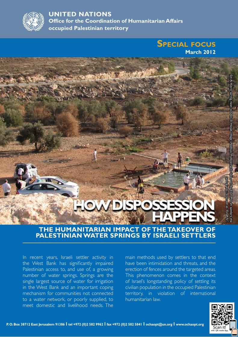
SPECIAL FOCUS March 2012 P. O. Box 38712 East Jerusalem 91386 l tel +972 (0)2 582 9962 l fax +972 (0)2 582 5841 l [email protected] l www.ochaopt.org UNITED NATIONS Office for the Coordination of Humanitarian Affairs occupied Palestinian territory THe HumAniTAriAn imPACT Of THe TAkeOver Of PAlesTiniAn wATer sPrings by isrAeli seTTlers In recent years, Israeli settler activity in the West Bank has significantly impaired Palestinian access to, and use of, a growing number of water springs. Springs are the single largest source of water for irrigation in the West Bank and an important coping mechanism for communities not connected to a water network, or poorly supplied, to meet domestic and livelihood needs. The main methods used by settlers to that end have been intimidation and threats, and the erection of fences around the targeted areas. This phenomenon comes in the context of Israel’s longstanding policy of settling its civilian population in the occupied Palestinian territory, in violation of international humanitarian law. HOw disPOssessiOn HAPPens HOw disPOssessiOn HAPPens HOw disPOssessiOn HAPPens Ein Al Kbire spring, next to Deir El Hatab village (Nablus). Following its takeover by Elon Moreh settlers the spring was renamed as “Ein Kfir”. Scan it! with QR reader App
Transcript of HOw disPOssessiOn HAPPens
Special focuS March 2012
P. O. Box 38712 East Jerusalem 91386 l tel +972 (0)2 582 9962 l fax +972 (0)2 582 5841 l [email protected] l www.ochaopt.org
uNiTeD NaTioNS Office for the Coordination of Humanitarian Affairsoccupied Palestinian territory
THe HumAniTAriAn imPACT Of THe TAkeOver Of PAlesTiniAn wATer sPrings by isrAeli seTTlers
In recent years, Israeli settler activity in the West Bank has significantly impaired Palestinian access to, and use of, a growing number of water springs. Springs are the single largest source of water for irrigation in the West Bank and an important coping mechanism for communities not connected to a water network, or poorly supplied, to meet domestic and livelihood needs. The
main methods used by settlers to that end have been intimidation and threats, and the erection of fences around the targeted areas. This phenomenon comes in the context of Israel’s longstanding policy of settling its civilian population in the occupied Palestinian territory, in violation of international humanitarian law.
HOw disPOssessiOn HAPPens
HOw disPOssessiOn HAPPens
HOw disPOssessiOn HAPPens
Ein Al K
bire spring, next to Deir El H
atab village (Nablus). Follow
ing its takeover by Elon Moreh settlers the
spring was renam
ed as “Ein Kfir”.
Scan it!with QR reader App

2 March 2012UN OCHA oPt
ExEcuTIvE SummarySuch works were carried out without building permits, as required by the ICA.
This practice is part of a larger trend entailing the development of the tourism infrastructure of Israeli settlements. This infrastructure contributes to the entrenchment of the settlement enterprise in at least three distinct ways: it expands the scope of territorial control of settlements; it adds a source of employment and revenue for the settler population; and it contributes to the “normalization” of settlements in the eyes of larger segments of Israeli society.
The takeover and development of springs by settlers has multiple ramifications on the daily lives of Palestinians living in affected areas, including the erosion of their agricultural livelihoods. Despite the decline in their yield, springs have remained the single largest water source for irrigation and a significant source for watering livestock. Albeit to a lesser extent, springs are also a source of water for domestic consumption. Households not connected to the water network, or those supplied on an irregular basis, rely on them as a coping mechanism to meet domestic needs, particularly during the summer. The loss of access to springs and adjacent land reduced the income of affected farmers, who either stop cultivating the land or face a reduction in the productivity of their crops. Others farmers, herders and households are confronted with increased expenditures, due to the need to purchase more expensive piped or tankered water.
The takeover of springs also undermines the scope of control over space for Palestinians in Area C of the West Bank, where Israel retains extensive control. This is because of the spatial interaction between the taken-over springs and other settlement infrastructure in the area, such as settlement outposts and industrial areas. The presence of armed settlers at multiple points in a given area intimidates residents and renders the space in-between those points practically off limits for Palestinian use.
In recent years, a growing number of water springs in the vicinity of Israeli settlements throughout the West Bank have become the target of settler activities that eliminated, or put at risk, the access to these springs and their use by Palestinians. A survey carried out by OCHA in the course of 2011 identified a total of 56 such springs, the large majority of which are located in Area C (93 percent), on land parcels recorded by the Israeli Civil Administration (ICA) as privately owned by Palestinians (at least 84 percent).
Thirty (30) of these springs were found to be under full settler control, with no Palestinian access to the area. In almost three quarters of these (22), Palestinians have been deterred from accessing the spring by acts of intimidation, threats and violence perpetrated by Israeli settlers. In the remaining eight springs under full settler control, Palestinian access has been prevented by physical obstacles, including the fencing of the spring area, and its de facto annexation to the settlement (four cases), and the isolation of the area from the rest of the West Bank by the Barrier and its subsequent designation as a closed military zone (four cases).
The other 26 springs are at risk of a settler takeover. This category includes springs that became the target of regular “tours” by settlers, and/or patrolling by the security coordinators of settlements. While at the time of the survey, Palestinians could still access and use these springs, farmers and residents reported that the constant presence of groups of armed settlers in the area has an intimidating effect that discourages access and use.
Along with the elimination or reduction of Palestinian access, in 40 out of the 56 springs identified in the survey, Israeli settlers have begun to develop the surrounding area into a “tourist attraction”. Works performed for this purpose include, among others, the construction or renovation of water pools; the deployment of picnic tables and shading structures; the paving of leading roads; and the installation of signs announcing the Hebrew name of the spring.

3March 2012UN OCHA oPt
3AugusT 2011un OCHA oPt
Settlements are illegal under international humanitarian law. Settlement related practices have also resulted in the infringement of a range of provisions in international human rights law, including those enshrining the right to property, to adequate housing, to freedom of movement, and to be free from discrimination, among others.
Most of the practices discussed in this study - including trespass, intimidation and physical assault, stealing of private property, and construction without a building permit - are illegal not only under international law but also under Israeli legislation. Yet, the Israeli authorities have systematically failed to enforce the law on those responsible for these acts and to provide Palestinians with any effective remedy.
The impact of the above practices and policies is not limited to those directly affected by settler violence and property losses. The continuous encroachment on Palestinian land for the purpose of settlement expansion is a key cause of humanitarian vulnerability of the Palestinian
population and the most significant reason behind the ongoing fragmentation of the West Bank, which undermines the right of the Palestinian people to self-determination.
To abide by its obligations under international law and begin addressing the humanitarian impact of the above practices, the Israeli authorities must:
• stop facilitating the transfer of Israeli civilians into the oPt, including by allowing the expansion of settlements;
• restore Palestinian access to the water springs taken over by settlers, and ensure their safety;
• conduct effective investigations into cases of settler violence and trespass and prosecute those responsible; and
• adopt measures to prevent ongoing settler “tours” to springs located on private Palestinian property.
Ein
Al A
riq
spri
ng, n
ext
to Q
aryu
t vi
llage
(N
ablu
s). F
ollo
win
g its
tak
eove
r by
Eli
sett
lers
the
spr
ing
was
re
nam
ed a
s “Ei
n H
agvu
ra”.
3March 2012UN OCHA oPt

4 March 2012UN OCHA oPt
InTroducTIon*
Natural water sources have historically played a key role in shaping the geography of human development, particularly in regions affected by water scarcity. In the West Bank, springs (areas where ground water flows naturally into the surface) had served for centuries as the principal source of water for all uses, triggering the development of villages and towns in their vicinity.
Springs remain the single largest source of water for irrigation in the West Bank, and an important coping mechanism for communities not connected to a network (or those supplied on an irregular basis) to meet domestic and livelihood needs. Springs are also an integral part of the West Bank landscape and open spaces, and as such they serve as sites for leisure and family recreation.
Over the past few years, however, Palestinian access to a growing number of springs has been significantly reduced, and often totally prevented, by Israeli settlers, mostly by threat and intimidation. In most cases, following the removal of Palestinian presence at a given spring and its surrounding areas, Israeli settlers have begun developing the area into a tourist attraction.
Israel has engaged in the settling of part of its civilian population in the occupied Palestinian territory since 1967, in violation of international humanitarian law. In this context, over two million dunams of private and public Palestinian land (nearly 40 percent of the West Bank) have been seized by the Israeli authorities, through a range of mechanisms, and allocated for the development of Israeli settlements.1 Land and other Palestinian properties have been also forcibly taken over by Israeli settler groups, without the formal authorization of the Israeli authorities, but with their acquiescence and often active support.2
The takeover of springs by Israeli settlers is just one instance of the latter type of settlement activity. This report presents and analyzes the findings of a survey assessing the characteristics and scope of this practice, as well as its humanitarian impact on the Palestinian population. The assessment consisted of extensive field visits carried out by OCHA, mainly during the spring and summer of 2011 to every known water spring in the vicinity
SPriNgS: A wAtEr SOUrCE At riSK OF ExtiNCtiON while the total number of springs throughout the west Bank is estimated at approximately 530, their discharge has experienced a dramatic decline in recent decades, with less than 20 percent having a significant volume of water discharge.3 in 2009, the overall water yield of springs was only half the equivalent figure six years earlier.4 this is the result of recurrent years of poor rainfall, exacerbated by israel’s over-extraction (i.e. extraction in excess of the estimated replenishment potential) of water from wells located both in the west Bank and in israel.5
of an Israeli settlement. Evidence collected during the field visits was supplemented and crosschecked with a range of other sources, including:
• interviews with Palestinian farmers;
• information by officials of local councils of affected Palestinian villages;
• land ownership maps produce by the Israeli authorities;
• information by Israeli settlers present at the spring at the time of the field visit;
• multi-year aerial photos of selected areas showing cultivation patterns across time; and
• Israeli guidebooks and websites advertising tourist sites in West Bank settlements.
The first section of the report presents the main findings of the survey and elaborates on the methods employed by Israeli settlers to remove the Palestinian presence at, and take control of, the springs. The second section addresses the key elements involved in the physical development of the springs taken over by settlers and their transformation into tourist sites. The third section highlights the humanitarian impact of these practices on Palestinian communities adjacent to the springs. The last section presents three cases studies concerning springs in the Ramallah, Nablus and Bethlehem governorates.
*this report is based upon a study commissioned to Mr Dror Etkes, and supplemented with further research by OCHA oPt. All photos were taken by Dror Etkes.

5March 2012UN OCHA oPt
TakIng ovEr ThE SPrIngSThe survey carried out for this report identified a total of 56 water springs located in the vicinity of Israeli settlements, which have become the target of settler activities that have eliminated or put at risk the access to the spring and its use by Palestinians.6 Approximately half of these springs (29) are located in the Ramallah governorate, followed by the Nablus (10) and Bethlehem (8) governorates. Four of the springs fall within Areas B, close to the boundaries with Area C, and the rest are located within Area C.
The total figure excludes springs where Palestinian access has been affected due to measures adopted by the Israeli authorities, but the site has not been subject to systematic settler activities. Such measures include access restrictions (e.g. checkpoints, roadblocks, the Barrier and “firing zones”)7, as well as the imposition of entry fees to springs located in areas declared “nature reserves”.8 However, all springs where regular settler activities were documented have been included, even if the restriction on Palestinian access resulted from measures adopted by the Israeli authorities.
Of the total number of springs identified, 30 are under full Israeli settler control with no Palestinian access to the area, while the other 26 are considered as being at risk of settler takeover (see below “settler tours” section).
In terms of ownership status, at least 47 of the springs (84 percent) are located on land parcels recorded by the Israeli Civil Administration (ICA) as privately owned by Palestinians.9 Another four springs are located on land considered by the ICA as pre-1948 “Jewish property” subsequently registered by the Jordanian authorities as “enemy property”. The ownership status of the remaining five springs could not be determined.
Finally, 11 of the springs identified in the survey were dry or had an insignificant discharge at the time they were visited (mostly during the summer), however, some of them reportedly become “active” during the rainy season or in years with abundant rainfall.
a. intimidation, threat and violence
In almost three quarters of the springs under full settler control (22 out of 30), the main method used to deter Palestinians from accessing the area of the spring has been intimidation and threats, and in some cases direct physical violence. The precise timing and sequence of events that led to the removal of Palestinian access and the takeover of each of these springs was in most cases difficult to reconstruct. Regarding many of the springs, the bulk of violent incidents occurred several years ago, while the halt in Palestinian use of the spring occurred gradually, based on the internalization of the level of threat.
The phenomenon of settler attacks and intimidation of Palestinians in agricultural areas in the vicinity of certain settlements is well documented.10 Incidents regularly reported by humanitarian and human rights organizations include shootings, beatings, verbal abuse and threats, stone throwing, unleashing of attack dogs, striking with rifle butts and clubs, destruction of farm equipment and crops, theft of crops, and killing or theft of livestock, among others. Between 2006 and 2011, OCHA recorded over 1,300 settler attacks throughout the West Bank resulting in either casualties or property damage.
A number of reports highlighted the key role played by the “security coordinators” of settlements in the reduction of Palestinian presence in adjacent rural areas.11 These coordinators are appointed, armed and paid by the Israel Defense Forces (IDF) to manage the security affairs of the settlement where they live. Their responsibilities and powers are defined in a military order, which makes them accountable to the IDF Brigade Commander in their area.12 While their sole responsibility is the protection of their respective settlements, until July 2009, the geographical area on which the security coordinators were authorized to operate was not defined. This gap contributed to their regular involvement in incidents in areas far beyond the outer limits of the settlements. Moreover,

6 March 2012UN OCHA oPt
!̂]
!̂]
!̂]
!̂]
!̂]
!̂]!̂]!̂]
!̂]
!̂]
!̂]!̂]
!̂]!̂]
!̂]
!̂]!̂]
!̂]
!̂]!̂]
!̂]
!̂]
!̂]
!̂]
!̂]
!̂]
!̂]
!̂]
!̂]!̂]
!̂]
!̂]
!̂]
!̂]!̂]
!̂]
!̂]
!̂]!̂]
!̂]
!̂]
!̂]
!̂]
!̂]
!̂]!̂]
!̂]
!̂]
!̂]
!̂]
!̂]
!̂]
!̂]
!̂]
!̂]
!̂]
!̂]
"J
"J
"J
"J
"J
"J"J
"J
"J
"J
"J
!̂]
Inte
rnat
iona
l Bou
ndar
y
De
ad
S
ea
Tubas
Jenin
Nablus
Hebron
Salfit
Tulkarm
JerichoRamallah
Bethlehem
Qalqiliya
East Jerusalem
¥
0 20 4010Km
Areas A,B
Area C
Spring at risk
Spring taken over !̂]!̂]
Govenorate Boundary
Green Line"J Govenorate Capital
Settlement Outerlimit
Palestinian Builtup Area
United Nations Office for the Coordination of Humanitarian Affairs occupied Palestinian territory
PAlEStiNiAN SPriNgS AFFECtED By SEttlEr ACtivitiESMarch 2012
!̂]
!̂]
!̂]
!̂]
!̂]
!̂]!̂]!̂]
!̂]
!̂]
!̂]!̂]
!̂]!̂]
!̂]
!̂]!̂]
!̂]
!̂]!̂]
!̂]
!̂]
!̂]
!̂]
!̂]
!̂]
!̂]
!̂]
!̂]!̂]
!̂]
!̂]
!̂]
!̂]!̂]
!̂]
!̂]
!̂]!̂]
!̂]
!̂]
!̂]
!̂]
!̂]
!̂]!̂]
!̂]
!̂]
!̂]
!̂]
!̂]
!̂]
!̂]
!̂]
!̂]
!̂]
!̂]
"J
"J
"J
"J
"J
"J"J
"J
"J
"J
"J
!̂]
Inte
rnat
iona
l Bou
ndar
y
De
ad
S
ea
Tubas
Jenin
Nablus
Hebron
Salfit
Tulkarm
JerichoRamallah
Bethlehem
Qalqiliya
East Jerusalem
¥
0 20 4010Km
Areas A,B
Area C
Spring at risk
Spring taken over !̂]!̂]
Govenorate Boundary
Green Line"J Govenorate Capital
Settlement Outerlimit
Palestinian Builtup Area
Ramallah 1218
Nablus 73
Bethlehem 62
Jerusalem 3
S f
Tubas 1
2
1
Hebron
Salfit
1
2
At Risk
Taken OverTaken Over

7March 2012UN OCHA oPt
despite their formal subordination to the Brigade Commander, it often became clear that the level of control exercised by the latter was limited. Anecdotal evidence even suggests that, in some cases, the roles were reversed, as the security coordinators, as well as other armed settlers, were observed giving instructions to soldiers and IDF commanders on the ground.13
b. Fences and Barrier
In about a quarter of the springs under full settler control (8 out of 30), the prevention of Palestinian access has been achieved, primarily, by the deployment of physical obstacles. In four of these springs, all in the vicinity of the Bet El settlement (Ramallah), the obstacle consists of a fence, enhanced by electronic devices. No land requisition orders or notification were given to the Palestinian landowners prior to the installation of this infrastructure, and no procedure to allow access of farmers to the closed areas was established.
The illegal expansion of the outer limits of settlements over Palestinian farming land by means of fences or patrol roads under the guise of security needs became a widespread practice in recent years.14 One Israeli human rights organization (Yesh Din) filed six separate petitions with the Israeli High Court of Justice (HCJ) demanding the removal of the illegal fences and the restitution of
UMM Al JArAB SPriNg, ‘AwArtA (NABlUS)“[…] i have land planted with olive trees in this area, and, as many other farmers from ‘Awarta, i used the water from the spring to irrigate the trees. Since the beginning of the Second intifada in 2000, the settlers from itamar became very aggressive and started to harass us… they also began coming to the spring to swim and water their sheep. i directly experienced only one incident, when a group of armed settlers approached me while I was working in the field, started threatening me and forced me to leave. For the last few years we can reach the land only a few times a year, at specific times following coordination with the israeli army […]. the most serious case happened with the soldiers: on 20 March 2010, they killed two young men from the village who were working the land near the spring without coordination… the army argued that they first arrested the boys, but then one of them attacked the soldiers. things became much worse after the killing of the settler family in itamar [March 2011] because the israeli army stopped the coordination process completely and no farmer could reach the area. Before that, i planted new olive seedlings that were all lost because of the lack of irrigation. together with the potential income from the oil, I lost over NIS 10,000…”
Jamil Darawsheh, farmer, ‘Awarta
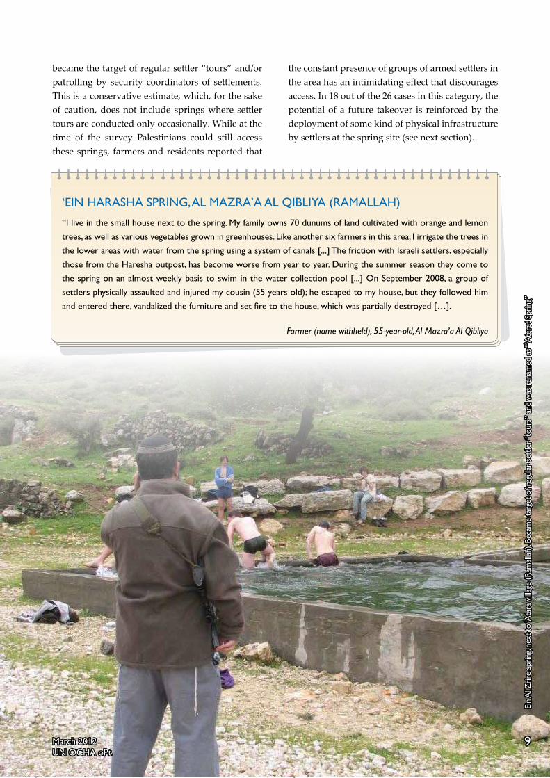
EiN Al ZrirE SPriNg, ‘AtArA (rAMAllAH)(See photo in p. 9)
“About a year ago i went with a friend to a piece of land near the spring belonging to a relative to collect wood. While we were walking, the security officer of ‘Ateret settlement appeared in his jeep and started questioning us about our presence there. A few minutes later, a group of 40 or 50 settlers arrived, surrounded us and began threatening us. they forced us to sit next to the spring for about one hour until two army vehicles arrived. the soldiers took us to the police station at Giv’at Ze’ev settlement, where we were briefly interrogated and released a few hours later […] while some farmers from ‘Atara still use the spring to irrigate their crops, many other farmers have avoided coming to this spring as much as possible due to fear from incidents like this…”
Farmer (name withheld), 31 years old, ‘Atara.

8 March 2012UN OCHA oPt
Palestinian access to the areas behind the fences. In a state response submitted in April 2010, the State Attorney requested to postpone any further discussion until a comprehensive examination of this practice is completed. All the petitions are still pending.15
Another four springs under full settler control are located in areas between the Barrier and the Green Line, which were declared as closed military zones (also known as the “Seam Zone”). Palestinian access to these areas is prohibited, unless they are granted a difficult-to-obtain “visitor permit”, or they live in a community located in the closed area and have obtained a “permanent resident” permit. The area of the four springs is particularly
inaccessible to Palestinians, including those holding special permits due to the application of additional impediments: two springs (next to Nabi Samuel village in the Jerusalem governorate) are located in an area declared by the Israeli authorities in 2001 as a “National Park”, that was fenced off; one (next to Al Jib village also in the Jerusalem area) became accessible only through a settlement (Giv’at Ze’ev); and another was declared as a closed military area in 1967.
c. Settler “tours”
A total of 26 springs were identified as being at risk of a settler takeover.21 This category includes springs located in the vicinity of settlements that
the root of the settler violence phenomenon is israel’s decades-long policy of illegally facilitating the settling of its citizens inside the occupied Palestinian territory (oPt). this activity has resulted in the progressive takeover of Palestinian land, resources and transportation routes and has created two separate systems of rights and privileges, favoring israeli citizens at the expense of over 2.5 million Palestinians.
As the occupying power, israel is responsible for ensuring public order and safety in the occupied territory, as well as for the protection of the civilian population from any act or threat of violence.16 However, as pointed out by various official commissions appointed by the Israeli authorities since the 1980’s, as well as by human rights organizations, israel has systematically failed to adequately enforce the law on settlers who engage in attacks against Palestinians and their property.17
One of the concerns identified is the failure of Israeli forces to intervene and stop settler attacks in real time, including the failure to arrest suspected settlers on the spot. Among the main reasons behind this failure is the ambiguous message delivered to the security forces in the field regarding their authority and responsibility to enforce the law on israeli settlers.18
Another two key reasons behind the ongoing law enforcement deficit are the disincentives given to Palestinian victims to file official complaints with the Israeli police, thus preventing the launching of an investigation, and the insufficient follow-up by the Israeli police in investigating complaints. Regarding the latter, according to the Israeli organization Yesh Din, more than 90 percent of the complaints filed with the Israeli Police and monitored by the organization in the past six years were closed without indictments.19
Recent, official efforts to retroactively “legalize” settlement outposts, which were built on private Palestinian land forcibly taken over by settlers, actively promote a culture of impunity and encourages further violence.20
SEttlEr viOlENCE AND iMPUNity
9March 2012UN OCHA oPt
became the target of regular settler “tours” and/or patrolling by security coordinators of settlements. This is a conservative estimate, which, for the sake of caution, does not include springs where settler tours are conducted only occasionally. While at the time of the survey Palestinians could still access these springs, farmers and residents reported that
the constant presence of groups of armed settlers in the area has an intimidating effect that discourages access. In 18 out of the 26 cases in this category, the potential of a future takeover is reinforced by the deployment of some kind of physical infrastructure by settlers at the spring site (see next section).
‘EiN HArASHA SPriNg, Al MAZrA’A Al QiBliyA (rAMAllAH)
“i live in the small house next to the spring. My family owns 70 dunums of land cultivated with orange and lemon trees, as well as various vegetables grown in greenhouses. like another six farmers in this area, i irrigate the trees in the lower areas with water from the spring using a system of canals [...] the friction with israeli settlers, especially those from the Haresha outpost, has become worse from year to year. During the summer season they come to the spring on an almost weekly basis to swim in the water collection pool [...] On September 2008, a group of settlers physically assaulted and injured my cousin (55 years old); he escaped to my house, but they followed him and entered there, vandalized the furniture and set fire to the house, which was partially destroyed […].
Farmer (name withheld), 55-year-old, Al Mazra’a Al Qibliya
Ein
Al Z
rire
sprin
g, ne
xt to
‘Ata
ra v
illage
(Ram
alla
h). B
ecam
e ta
rget
of r
egul
ar s
ettle
r “to
urs”
and
was
ren
amed
as “
’Ate
ret S
prin
g”
9March 2012UN OCHA oPt

10 March 2012UN OCHA oPt
Along with the elimination or reduction of Palestinian access, in 40 out of 55 springs identified in the survey, Israeli settlers have begun to develop the area surrounding the spring. While the level of investment differs from one to another, works include at least one of the following elements: the construction or renovation of a pool collecting the water from the spring; the deployment of benches, picnic tables, trash containers, and/or shading structures; the paving or upgrading of leading roads; the construction of a parking lot; and the installation of signs leading to the site, as well as next to the spring announcing the Hebrew name of the spring.
Granting springs Hebrew names adds a symbolic dimension to the process of appropriation. While some of the names are a simple transliterations of the original Arabic names (e.g. from ‘Ein Al Dweer to ‘Ein Dvir), in other cases, springs are called after individuals to be commemorated, usually founders of the nearby settlement, victims of Palestinian attacks, or soldiers killed in combat (e.g from ‘Ein Sijma to ‘Ein Yitzhak).22
A recent media article pointed out to the existence of a small group of Israeli volunteers called “the Abrabanels”, whose sole goal is to “discover” and “renovate” springs primarily in areas adjacent to settlements.23 According to the article, this group was responsible for the initial development of at least seven of the springs identified in this survey, usually the construction or expansion of a water pool. In other cases, individuals or small groups from the nearby settlement, often involving religious youngsters, have taken the lead. Participation in this kind of initiative is perceived among some segments of the settler population as part of the “spiritual formation” of the youth.24
Some of the springs have signs pointing out the involvement of official Israeli bodies in the funding, development or maintenance of the site, mainly the regional councils of settlements. The latter, function as the local government of small and medium size
SPrIngS and ThE rISE of ThE SETTlEr TourIST InduSTry
settlements and are generously funded by the central government, primarily through the Ministry of Interior.25 In two cases, signs installed on the ground indicate the involvement of the Jewish National Fund, the Nature and Parks Authority, and the IDF.
Given that at least 83 percent of the springs are located on land considered by the Israeli authorities as private Palestinian property, it can be reasonably assumed that works performed by settlers on those sites were carried out without building permits.26 Yet, as regarding other illegal settler activities, the Israeli authorities consistently failed to enforce the law and demolish or remove the unauthorized structures.
One of the single exceptions identified in this study concerns the ‘Ein Al Kbire spring, next to Deir El Hatab village, in the Nablus governorate (see cover picture). This spring was taken over by settlers from the nearby settlement of Elon Moreh, who succeeded in eliminating Palestinian access completely, and renamed it as “Ein Kfir” in commemoration of an IDF soldier (Avner Kfir) killed on duty. In 2008, the soldier’s family and friends constructed a pool and a memorial next to the spring, which were demolished by the ICA in November 2010, on grounds of lack of permit.27 However, shortly after the demolition the water pool and the memorial were reconstructed and a new parking lot developed with the support of the Samaria Regional Council, without further interference from the ICA.
The takeover and development of water springs is part of a larger trend entailing the promotion of the tourism infrastructure in Israeli settlements. This trend includes a range of endeavors such as the development and promotion of archeological sites and museums; new hiking and “off road” biking trails; observatories and scenic spots; guest houses and other accommodation facilities; tours of wine and olive oil establishments;28 and regular cultural and artistic events. Most such facilities and events

11March 2012UN OCHA oPt
“During the past two years there has been tremendous development in tourism. As part of the development plans of the Tourism Ministry and the regional council, we are also repairing murky springs and turning them into enjoyable tourist sites. The springs are not the council’s private property and they are open to the general public. For clear security reasons, and in the wake of past terror attacks, the Israel Defense Forces does not allow Arabs’ access to the springs near the settlements. Other springs are open and accessible to everyone.”31
The development of the tourist infrastructure of Israeli settlement contributes to the entrenchment of the settlement enterprise in at least three distinct ways: it expands the scope of territorial control of settlements; it adds a source of employment and revenue for the settler population; and it contributes to the “normalization” of settlements in the eyes of large segments of Israeli society, as well as some foreign tourists. The opening paragraph of a recently published guidebook for “boutique tourism” in West Bank settlements captures the essence of the latter goal:
“It may be surprising, but Judea and Samaria are not just settlements flashing ideology. There is also, and primarily, a good life. An excellent soil for wine and olives, exciting spaces, artists who create, sweet B&B, gourmet restaurants, sheep farms. Why not?32
are practically off limits for Palestinians, either due to their location within the municipal boundaries of settlements, where Palestinian access is prohibited by military order, or due to fear from harassment.
Many of these initiatives are promoted and funded (partially or entirely) by Israeli governmental or semi-governmental institutions including the local and regional councils of settlements, the Ministry of Tourism, the Nature and Parks Authority, and the Jewish National Fund. Of the six settlement regional councils that operate in the West Bank, the Binyamin Council, which includes all settlements in the Ramallah Governorate, has taken the lead. In its 2011 budget, for example, the council allocated over NIS 4.4 million to its Department of Tourism, including NIS 300,000 for “infrastructure development”; NIS 95,000 for deploying “orientation signs for tourism”; NIS 30,000 for publicity and NIS 25,000 for the maintenance of touristic sites.29
Settler touristic sites and businesses are regularly promoted and advertised among the Israeli Jewish public. Binyamin’s website, for example, contains a multilayered section dedicated to tourism in settlement sites, including a separate page advertising 17 water springs “renovated” by settlers in the Ramallah area.30 The settler touristic industry succeeded, to a significant extent, to penetrate the mainstream Israeli media, internet activity and literature dealing with “domestic” tourism.
In response to a media article on this subject published in 2010, a spokesperson of the Binyamin Regional Council stated:

12 March 2012UN OCHA oPt
The practices documented in this survey have multiple ramifications on the daily lives of Palestinians living in the affected areas, including erosion of agricultural livelihoods, deterioration in physical security and a heightened sense of threat, and increasing loss of control over space.
Despite the decline in their yield, springs have remained the single largest water source for irrigation and a significant source for livestock watering.33 Albeit to a lesser extent, springs are also a source of water for domestic consumption.34 Households not connected to the water network, or those supplied on an irregular basis, rely on them as a coping mechanism to meet domestic needs, particularly during the summer.
Due to methodological impediments, the total amount of water that became unavailable to Palestinians because of the practices addressed in this report, as well as the related effect on their income, could not be quantified. However, information collected during this survey, and illustrated in the case studies presented herein, suggests that the overall impact on the livelihoods of affected communities is significant.
Of all springs identified in the survey, some three quarters are, or were used in the past, by Palestinians for irrigation, for the watering of livestock, or for both. For many of the affected farmers, however, the main impact of the practices addressed in this report is the loss of access to farming land in the vicinity of the spring and the resulting loss of income from agricultural produce. Others, who have continued cultivating the land or grazing their livestock in the vicinity of the area taken over by settlers, were compelled to rely on alternative and more expensive water sources, or faced a decline in productivity due to the shift to exclusive reliance on rainfall.
Approximately 60 percent of the springs identified in the survey, including many of those used for irrigation, are or were also used as a complementary
ThE humanITarIan ImPacTsource to meet domestic needs (drinking, cooking, hygiene, cleaning, etc). For such communities and households, the loss of access to the spring resulted in increased expenditures on the purchase of water delivered by water tankers. In distant areas affected by access restrictions, such as Bedouin communities in the northern Jordan Valley, residents pay up to NIS 25 per cubic liter of tankered water, which is more than five times the price of piped water distributed to the network.35
The negative impact of the settler takeover of springs and adjacent orchards is not limited to the livelihoods of people, but extends also to other aspects of their life, such as family recreation. This function has become increasingly important since the beginning of the second Intifada, as a result of the loss of access to areas that served that purpose, such as the Dead Sea coast, as well as green areas now located behind the Barrier.
The seizure and development of springs as tourist attractions also played an important role in solidifying the settler control over space, much beyond the specific spots taken over. This is due to the strategic location of many of the springs vis-à-vis other sites developed by settlers in the same area, such as settlement outposts and touristic attractions other than springs. The presence of armed settlers at multiple points in a given area intimidates residents and has rendered the space in-between those points practically off limits for Palestinian use.
The effect of such a spatial dynamic is evident in the area of the Shilo-Eli settlement block (see map). Since the late 1970’s, the Israeli army requisitioned, or declared “state land”, thousands of dunams in this area for the establishment of both settlements.36 Later on, and until 2003, settlers took over strategic points around this block and established ten unauthorized settlement outposts, along with the appropriation and subsequent cultivation of private Palestinian land in their vicinity. An archeological site (‘Tel Shilo’) operated by settlers, covering an area of approximately 150 dunams, was also

13March 2012UN OCHA oPt
Uni
ted
Nat
ions
Offi
ce fo
r th
e C
oord
inat
ion
of H
uman
itari
an A
ffair
s oc
cupi
ed P
ales
tinia
n te
rrito
ry SEt
tlE
MEN
tS’
SPA
tiA
l C
ON
trO
l: E
li-S
Hil
O S
Ett
lEM
ENt
BlO
CK
Fe
brua
ry 2
012
!̂ ]
!̂ ]
!̂ ]
ñ
Alon Road
B ?60
B ?458
B ?505
B?4777
B?5077
B ?458
B ?4775
Hay
ovel
Nof
Har
im
Ade
i Ad
Ahi
yaG
ivat
Har
el
Pal
gei H
ayim
Esh
Kod
esh Hab
ayit
Ha'
adom
Har
o'e
Hill
Kid
a
Tel S
hilo
Eli
Shi
loSh
vut R
ache
l
Ma'
ale
Levo
na
Sinj
il
Qus
ra
Turm
us'a
yya
Qar
yut
As S
awiy
aTa
lfit
Qab
alan
Jalu
d
Jilij
liya
Khirb
et A
bu F
alah
Al M
ugha
yyir
Khirb
et S
arra
Maj
dal B
ani F
adil
Yatm
a
Al L
ubba
n a
sh S
harq
iya
Ein
Al A
riq
Ein
Al M
ukhe
iber
¥
Ram
alla
h
Nab
lus
Settl
emen
ts' S
patia
l Con
trol
: El
i-Shi
lo S
ettle
men
t Blo
ck
Pale
stin
ian
Com
mun
ity
Area
s A,
B
Area
C
Sprin
g at
risk
Sprin
g ta
ken
over
Settl
emen
t Bui
lt-tp
are
a
Settl
emen
t Mun
icip
al b
orde
r
Settl
emen
t Out
post
(out
er-li
mit)
!̂ ] !̂ ] ñAr
chae
logi
cal S
ite
01
20.
5Km
UN
ITED
NA
TIO
NS
Offi
ce fo
r th
e C
oord
inat
ion
of H
uman
itari
an A
ffair
s, oc
cupi
ed P
ales
tinia
n te
rrito
ry
SEt
tlE
MEN
tS’
SPA
tiA
l C
ON
trO
l: E
li-S
Hil
O S
Ett
lEM
ENt
BlO
CK
M
arch
201
2

14 March 2012UN OCHA oPt
developed next to the Shilo settlement.37 Given their specific location, the takeover and development of the ‘Ein Al ‘Ariq (see photo in p.3) and ‘Ein el Muheiber springs, significantly contributed to consolidating settler control over the area between these and other sites.
The regular presence of armed settlers at the springs and their surroundings resulted in a hightened
sense of threat among men, women and children living in nearby Palestinian communities, due, in part, to increased friction and clashes. In at least one case, the takeover of a spring also triggered weekly protests, which evolve into clashes with Israeli forces that lead to casualties and arrests (see next section).
Since the beginning of its occupation in 1967, israel has established and maintained a system of direct control over the exploitation and distribution of west Bank water resources. this system, which includes a restrictive permit regime applying to the development of any water-related infrastructure, has been operated to the benefit of the israeli population, both in israel and in the settlements, at the expense of the water needs and rights of Palestinians.
in the context of the Oslo accords signed during the 1990’s, an israeli-Palestinian Joint water Committee (JwC) was established and given the authority to regulate the use of water resources in the occupied Palestinian territory (oPt). Despite the existence of Palestinian representation at the JwC, this mechanism granted israel the ability to veto or delay water-related projects (including in Areas A and B). In addition, projects to be implemented in Area C, which covers over 60 percent of the west Bank, also require a permit by the iCA, which is exclusively run by israel. Under the israeli interpretation of the accords, this requirement applies even to the renovation of existing wells and cisterns. This multilayered system of approvals has resulted in the rejection and delay of dozens of water projects submitted by the Palestinian Authority. 38
During the course of the occupation, Palestinians have been denied access to water from the Jordan river, which is the main surface water resource in the west Bank.39 As a result, the Mountain Aquifer became the single water source accessible to them for domestic and agricultural needs. this aquifer is a transboundary water resource, which, according to international law, shall be used by israelis and Palestinians in an equitable and reasonable manner. in practice, it is estimated that israel uses over 86 percent of the water extracted from the aquifer, compared to
less than 14 percent by Palestinians.40
The inequality in the distribution of the shared resources is reflected in the immense gaps in the water consumption for domestic needs of israelis (both in the west Bank and in israel), which stands at an average of approximately 300 liters per capita per day (l/d/c), compared to about 70 l/d/c by Palestinians, well below the standard of 100 l/c/d recommended by the world Health Organization (wHO).41 All the settlements officially recognized by the Israeli authorities, as well as many unauthorized outposts, are connected to a water network and serviced by the israeli national water utility (Mekorot) from wells in the west Bank and in israel. Most of the water allocated to them is used to produce agricultural goods for export. governmental subsidies given to settlements, including those for their agriculture products, help offset costs of water and other utilities.42
On the other hand, approximately 300,000 Palestinians across the west Bank are vulnerable to water scarcity. this include some 14,000 people living in about 100 herding communities in Area C without any water infrastructure, who access less than 30 l/d/c. These communities rely on the delivery of water by tankers, at prices up to five times higher than piped water. water collection structures built in those communities without permits from the israeli authorities, which are almost impossible to obtain, are issued demolition orders; in 2011 alone, 70 such structures were actually demolished.
iSrAEl’S MANAgEMENt OF wESt BANK wAtEr rESOUrCES

15March 2012UN OCHA oPt
‘Ein Al Qaws, An Nabi Salih (ramallah)
‘Ein Al Qaws is the biggest of five springs located along the Raya valley, which extends between the villages of An Nabi Salih and Deir Nidham in the northwest section of the Ramallah governorate. The two villages, with a combined population of 1,600, are part of the same “land block” (an administrative division for land registration and taxation purposes), which covers 4,765 dunams. The Raya valley is considered the most fertile area within this block.
In October 1977, the Israeli cabinet approved the establishment of a new settlement named “Hallamish” (also known as Neve Zuf) next to An Nabi Salih village, on a site that served prior to 1967 as a Jordanian military camp. A year later, some 600 dunums of privately owned land next to that camp were requisitioned for “military needs” and allocated to the settlement.43 Additional hundreds of dunums were seized over the following decade after declaring them “state land”.44 The current official boundaries of Hallamish, encompass 2,510 dunams, of which approximately 20 percent are built-up and home to some 1,100 Israeli settlers.45
In addition to the official land seizures, since the beginning of the second Intifada in 2000, settlers have gradually taken over 450 dunams of the Raya valley that fall outside the official boundaries of Hallamish, and de-facto annexed them to the settlement (see Map). The takeover entailed the fencing of these areas, the opening of roads within it and the cultivation of the land (see photo in p.18).
“Law enforcement” and the takeover of the spring
Overall, the takeover of private land around the settlement proceeded smoothly and without interference by the Israeli authorities. In November 2008, however, the ICA partially dismantled a fence de facto annexing land north of the settlement’s built up area, on grounds that the fence was
caSE STudIES
erected without a building permit. This step was not followed by measures aimed at stopping the cultivation of the previously fenced off area by the settlers, let alone returning the land to its Palestinian owners. Moreover, while the fence served to consolidate the annexation of the area to the settlement, it also constituted a physical barrier between the settlement and the rest of An Nabi Salih lands. As a result, the dismantlement of the fence, along with absence of any additional enforcement measure, triggered further encroachment on the village’s land, including the rapid takeover of ‘Ein Al Qaws spring.
Ein
Al Q
aws
spri
ng, r
enam
ed a
s “M
a’ay
an M
eir”
.

16 March 2012UN OCHA oPt
!̂]
!̂]
!̂]
!̂]
!̂]
B?450
B?465
B?465
Deir Nidham
An Nabi Salih
Beit Rima (Bani Zeid)
Ein Khaled
Ein Al Raya
Ein Al Qaws
Ein El Zama'a
Elisha Pre-Military Preparatory
Hallamish (Neve Zuf)
¥
Ramallah
Jeric
ho
Ein Al Qaws Spring, An-Nabi Salih
Palestinian Builtup Area
Settlement Outerlimit
Areas A,B
Area C
Spring at risk
Spring taken over
Settlement Built-tp area
Settlement Municipal border
Land Block Boundary
!̂]!̂]
Settlement Outpost( outer-limit)
0 0.5 10.25Km
United Nations Office for the Coordination of Humanitarian Affairs occupied Palestinian territory
SEttlEMENtS’ SPAtiAl CONtrOl: Eli-SHilO SEttlEMENt BlOCK February 2012
UNITED NATIONS Office for the Coordination of Humanitarian Affairs, occupied Palestinian territory
EiN Al QAwS SPriNg, AN-NABi SAliH March 2012

17March 2012UN OCHA oPt
Indeed, since late 2008, groups of Hallamish youngsters started “visiting” the spring on a regular basis and developing its surroundings. In the course of a few months a new water pool was built, picnic benches and tables were installed, and a shading structure constructed. Also, a large sign was placed on a rock next to the spring announcing the new name of the spring: “Meir Spring”, after Meir Segal who, according to the sign, was one of the founders of Hallamish.
While the takeover and renovation of the spring seems to be a local initiative, the Binyamin Regional Council supported it by recommending this site in the touristic section of its website.46 The regional council also added a brown road sign (in Hebrew and English) next to the spring, for the orientation of visitors. The same kind of signs can be found next to other water springs in the Ramallah area (see photo in p.11).
Given that, according to ICA records, the spring area is privately owned by Palestinians, all settler works at the spring were presumably carried out without ICA building permits.47 In the months following the takeover, residents of An Nabi Salih filed with the Israeli Police six separate complaints about trespass, property damages and physical assault, of which, five were closed on grounds of “offender unknown” and one on grounds of “lack of evidence”.48
In February 2010, the ICA issued a military order declaring the spring and its surroundings (15 dunams) an “archeological site”, where any type of development is forbidden.49 Following this declaration the IDF Brigade Commander for this area informed the heads of An Nabi Salih and Deir Nidham Village Councils that the settler infrastructure at the spring will be removed. This decision came in the context of the growing clashes and public interest in the regular demonstrations protesting the takeover (see below). However, to date, none of the infrastructure on the ground has been removed.
Loss of livelihoods
The rapid expansion of Hallamish settlement, which resulted in the loss of over 1,000 dunums of private and public land previously used for farming or grazing, has been a key factor undermining the agricultural livelihoods of An Nabi Salih and Deir Nidham residents. The takeover of the ‘Ein Al Qaws spring was the latest step in this 35-year-long process.
The spring itself falls within a four dunam plot of land owned by Bashir Tamimi (current head of An Nabi Salih Village Council). For a long period prior to its takeover, this plot had been leased to Munjed Tamimi, from Deir Nidham village, and provided income for his nuclear family, including his four children. The plot has been regularly cultivated with wheat and yielded about seven tonnes per season on average, generating a yearly income of approximately NIS 8,000; seasonal crops, such as tomatoes and cucumbers, were also planted and used for household consumption.
Until 2009, ‘Ein Al Qaws was used for irrigation not only by Munjed Tamimi but also by ten other farmers who cultivate a range of field crops and fruit trees (mainly olive, almond and fig) in the Raya valley, as well as by a number of herders. Despite frequent settler harassment, the rest of the farmers have continued cultivating the land. However, since the spring’s takeover, they have been forced to rely on alternative and more expensive water sources for irrigation, such as the local network and water tankering. Overall, the denial of access to the spring negatively impacted the agricultural livelihoods of at least another 70 people (excluding herders).
Protests and insecurity
The takeover of the spring also resulted in a deterioration in the physical security of the Palestinian residents. This is not only because of the regular presence of armed settlers at the spring and the adjacent areas, but primarily due the weekly protests carried out by Palestinians, Israelis and

18 March 2012UN OCHA oPt
internationals, and the ways in which Israeli forces are trying to suppress the protests.
Most protests evolve into violent confrontations with Israeli forces as soon as the demonstrators reach the edge of the village’s built up area. Clashes usually involve stone throwing by some demonstrators, along with the shooting of large amounts of tear gas, stun grenades and pepper spray, as well as by beating demonstrators with clubs and kicking and punching them, by the Israeli forces. Rubber-coated metal bullets and live ammunition are also used, but much less frequently.50 Between 2009 and 2011, one demonstrator was killed and another 185, including 26 children, were injured; during that period 12 members of the security forces were injured in such clashes.
In order to reduce the number of people attending the demonstrations, a military order declaring the entire built area of An Nabi Salih, as well as the area around the spring, as a closed military zone is
issued every Friday. The order prohibits the entry of any person who is not a resident of the village to the designated areas between 6AM and 10PM, and is enforced by soldiers staffing a partial checkpoint controlling access to the village, as well as by deploying multiple ad-hoc “flying” checkpoints across other routes.
Finally, while the bulk of the violence takes place on Fridays over the course of the protests, residents of An Nabi Salih, have suffered from regular night raids and search operations throughout the week by Israeli forces. Village’s residents have also reported being subject to a range of anonymous threats by telephone in connection to the protests.51 Psychosocial interventions have shown that military operations and violence permeating almost every home in the village had a particularly negative impact on children, including feelings of fear, insecurity and frustration that affect the coping mechanism of the community at large.
Fenc
e in
stal
led
by H
alla
mis
h se
ttle
rs n
ext
to ‘E
in A
l Qaw
s sp
ring
, de-
fact
o an
nexi
ng 1
35 d
unam
s of
pri
vate
Pal
estin
ian
land
.
18 March 2012UN OCHA oPt

19March 2012UN OCHA oPt
‘Ein Al Mahna, Burin (Nablus)
Burin village (population 3,700) is located eight kilometers south of Nablus City. The boundaries of its “land block” (see reference above) includes the adjacent village of ‘Iraq Burin (1,100 people) and covers an area of 18,470 dunams. The availability of the land and water resources in this large area for Palestinian use, however, has been constantly shrinking in the past 35 years due to the seizure of land for the establishment and expansion of Israeli settlements and military bases.
The main development relevant to this report occurred in January 1982, when the Israeli military requisitioned 200 dunums around a hilltop north of the village for the establishment of a military outpost (also know as “Nahal”), which a year later was handed over to settlers and named “Har Bracha”.52 In the next few years, more than 2,000 dunums were declared “state land” and allocated for the expansion of the settlement, whose current population is about 1,700 people.
‘Ein Al Mahna is the biggest of seven water springs in the area of Burin, located about one kilometer south of Har Bracha. Due to its location on land privately owned and cultivated by Palestinians, none of the above orders and declarations included the area of the spring. However, two of the roads connecting the settlement southwards had encircled the spring from three sides, starting the process that would lead to its isolation from Burin and takeover by settlers.53 The next significant benchmark in this direction occurred in 1998, when a new settlement outpost named “Sne Ya’akov” was established south of ‘Ein Al Mahna, leaving the spring and the dirt road connecting it to Burin between the two settlements.
In 2001, following the beginning of the second Intifada, the latter road was blocked by the Israeli military at both ends, rendering the spring, along with some 900 dunums of privately owned
land next to it, largely inaccessible to Palestinians. While the roadblock on the path leading from Burin to ‘Ein Al Mahna was subsequently removed, to date only Palestinians employed in the settlement and holding special permits are allowed to use the road. The prohibition is enforced by Israeli army patrols and an ad-hoc ‘flying’ checkpoints deployed at the entrance of the road on a daily basis.54
Since 2004, following the elimination of Palestinian access to the area, settlers from Har Bracha began developing the spring and cultivating some of the land around it (approx. 100 dunums) with olives and grapes. The spring was also given two separate Hebrew names that are used interchangeably: “Ein Amasa” and “Ein Yosef”.55 Works on the ground included the construction of a small structure on top of the spring, which is used as a Jewish ritual bath for men, due to the purifying qualities attributed to the water.56 Picnic tables and benches, as well as a pool collecting the water from the spring, were also added with the financial support of the Samaria Regional Council.
As elsewhere, even though the works were carried out on privately owned Palestinian land without obtaining building permits, the Israeli authorities have refrained from taking any law enforcement measure against the settler trespassers. To the
Fenc
e in
stal
led
by H
alla
mis
h se
ttle
rs n
ext
to ‘E
in A
l Qaw
s sp
ring
, de-
fact
o an
nexi
ng 1
35 d
unam
s of
pri
vate
Pal
estin
ian
land
.
Building on top of Al Mahna spring, used for Jewish ritual baths (mikve).

20 March 2012UN OCHA oPt
contrary, a military order and map delineating the “operational area” of the security coordinator of Har Bracha, issued in 2009, included within it the ‘Ein Al Mahna spring.57 This inclusion, despite the location of the spring more than 1,000 meters from the settlement’s outer limits and about 250 meters below it, constituted a strong signal by the Israeli authorities that the spring is a de facto part of the settlement.
Prior to its takeover by settlers, ‘Ein Al Mahna spring served for the irrigation of some 400 dunums of land cultivated by Burin’s farmers in the immediate vicinity of the spring. The spring was also used to water the village’s livestock. However, due to the reduction in the access to grazing areas and natural water sources, and the resulting increase in expenditures (fodder and paid water), the overall size of the herds shrunk during the past decade from 3,000 to 600 heads. Ali E’id, the head of Burin’s local council, estimates that the loss of access to
the ‘Ein Al Mahna area alone directly affected the income of approximately 100 nuclear families. The livelihoods of the village’s residents have been also undermined by the takeover of an additional two springs, along with the pollution of another spring due to settler activities.
Along with settlement expansion around the village, attacks and insecurity also increased. Burin’s location in-between the settlements of Har Bracha, Sne Ya’akov and Yitzhar, which are considered strongholds of the Israeli radical right, made the village one the most vulnerable to settler violence. In the past five years, OCHA has recorded 64 settler attacks in the village that resulted in either casualties or property damage.
Pool
col
lect
ing
wat
er fr
om ‘E
in A
l Mah
na s
prin
g. Si
gn in
the
ben
ch c
redi
ts t
he
Sam
aria
reg
iona
l Cou
ncil.
20 March 2012UN OCHA oPt

21March 2012UN OCHA oPt
‘Ein Al Sijme, Nahalin (Bethlehem)
‘Ein Al Sijme spring is located within the “land block” boundaries of Nahalin village, in the Bethlehem governorate. Ownership of the land around the spring (approximately 700 dunams) is with three separate families from Bethlehem City. However, since the 1930’s, these families have leased the land for cultivation to another family (the Thawabta family), under the terms of a traditional arrangement (Muzara’a), by which the peasant cultivates the land in exchange of two thirds of the value of the crops.58
From 1969 onwards, ‘Ein Al Sijme and the adjacent farming land became gradually surrounded by four Israeli settlements - Alon Shvut, Kfar Etzion, Rosh Tzurim and Bat Ayin. While the latter three were originally established on land purchased by Jews prior to 1948 (and subsequently declared by the Jordanian authorities as “enemy property”), the former involved the requisition for “military needs” of more than 2,200 dunams of land from Palestinian residents.59 Between 1998 and 2001, the municipal boundaries of these four settlements were significantly expanded onto additional areas, mainly within parts of the Nahalin and Al Jab’a land blocks, that had been previously declared as “state land”. At present, the boundaries of these settlements encompass approximately 12,500 dunams with a combined population of about 6,000.
According to testimonies given to OCHA by some of the landowners and the farmer of the land, since the early 1990’s, groups of Israeli settlers (apparently from Bat Ayin settlement which was established in 1989) began visiting the spring area and planting trees on it. While the trees were subsequently uprooted by the landowners, settlers began regularly harassing and threatening members of the Thawabta extended family. At the time, the family consisted of 23 members, including eight children, all of whom resided in a cave in the spring area. The vulnerability of the family vis-à-vis settler harassment was exacerbated by the relative isolation of the spring area from nearby Palestinian towns, as well as by the fact that most members of the families that owned the land, who could potentially support them, left the country during that period. Three years later (1993), the family left the cave and a year after it stopped cultivation in the area. Despite the long time that passed, remainders of the vineyards and orchards are to date still visible on the ground.
The largest impact of the spring’s takeover fell on the Thawabta family, who was forcibly displaced and lost its only source of income. In absolute terms, however, the loss of the three landowner families was larger, as it included the value of the land itself, as well as the regular income from one third of the value of the crops.
Fenc
ed o
ff po
ol c
olle
ctin
g w
ater
from
‘Ein
Sijm
a sp
ring
.
21March 2012UN OCHA oPt
22 March 2012UN OCHA oPt
A StOry OF DiSPOSSESSiON AND DiSPlACEMENt
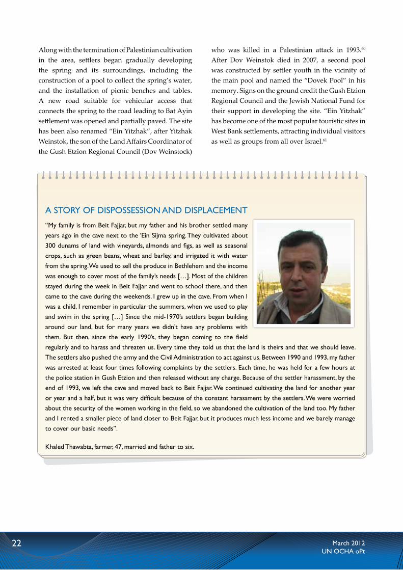
“My family is from Beit Fajjar, but my father and his brother settled many years ago in the cave next to the ‘Ein Sijma spring. They cultivated about 300 dunams of land with vineyards, almonds and figs, as well as seasonal crops, such as green beans, wheat and barley, and irrigated it with water from the spring. we used to sell the produce in Bethlehem and the income was enough to cover most of the family’s needs […]. Most of the children stayed during the week in Beit Fajjar and went to school there, and then came to the cave during the weekends. i grew up in the cave. From when i was a child, i remember in particular the summers, when we used to play and swim in the spring […] Since the mid-1970’s settlers began building around our land, but for many years we didn’t have any problems with them. But then, since the early 1990’s, they began coming to the field regularly and to harass and threaten us. Every time they told us that the land is theirs and that we should leave. the settlers also pushed the army and the Civil Administration to act against us. Between 1990 and 1993, my father was arrested at least four times following complaints by the settlers. Each time, he was held for a few hours at the police station in gush Etzion and then released without any charge. Because of the settler harassment, by the end of 1993, we left the cave and moved back to Beit Fajjar. We continued cultivating the land for another year or year and a half, but it was very difficult because of the constant harassment by the settlers. We were worried about the security of the women working in the field, so we abandoned the cultivation of the land too. My father and I rented a smaller piece of land closer to Beit Fajjar, but it produces much less income and we barely manage to cover our basic needs”.
Khaled thawabta, farmer, 47, married and father to six.
Along with the termination of Palestinian cultivation in the area, settlers began gradually developing the spring and its surroundings, including the construction of a pool to collect the spring’s water, and the installation of picnic benches and tables. A new road suitable for vehicular access that connects the spring to the road leading to Bat Ayin settlement was opened and partially paved. The site has been also renamed “Ein Yitzhak”, after Yitzhak Weinstok, the son of the Land Affairs Coordinator of the Gush Etzion Regional Council (Dov Weinstock)
who was killed in a Palestinian attack in 1993.60 After Dov Weinstok died in 2007, a second pool was constructed by settler youth in the vicinity of the main pool and named the “Dovek Pool” in his memory. Signs on the ground credit the Gush Etzion Regional Council and the Jewish National Fund for their support in developing the site. “Ein Yitzhak” has become one of the most popular touristic sites in West Bank settlements, attracting individual visitors as well as groups from all over Israel.61

23March 2012UN OCHA oPt
Settlements are illegal under international law as they violate Article 49 of the Fourth Geneva Convention, which prohibits the transfer of the occupying power’s civilian population into occupied territory. This illegality has been confirmed by the International Court of Justice, the High Contracting Parties to the Fourth Geneva Convention and the United Nations Security Council. Settlement policies and practices have also resulted in the infringement of a range of provisions in international human rights law, including those enshrining the right to property, to adequate housing, to freedom of movement, and to be free from discrimination, among others.
The concern about the continuous violation of international humanitarian and human rights law is not only a matter of principle, of interest for legal scholars or politicians. For many Palestinian men, women and children in the West Bank, settlements are a reality they must confront daily, a reality which undermines their security and impedes their ability to meet basic needs. The specific practices documented in this report constitute, to some extent, a microcosm that highlights some of the key challenges and ramifications stemming from settlement activities.
As other forms of settlement expansion, the takeover of springs has resulted in the shrinkage of space and amount of water available for Palestinians to sustain their livelihoods. The regular presence of armed settlers at the springs and their surroundings also undermine the physical security afforded by Palestinians from nearby communities, due, in part, to increased friction and clashes. Similarly to other Palestinian resources and properties seized by Israeli settlers, the water springs are being exploited to further the economic and political interests of settlers through the development of their touristic
concluSIonS and Way forWardinfrastructure. Most of the practices involved in this phenomenon - including trespass, intimidation and physical assault, stealing of private property, and construction without a building permit - are illegal, not only under international law, but also under Israeli legislation. Yet, as in other cases of illegal settler activity, the Israeli authorities have systematically failed to enforce the law on those responsible for these acts and to provide Palestinians with any effective remedy.
The impact of the above practices and policies is not limited to those directly affected by settler violence and property losses. The continuous encroachment on Palestinian land for the purpose of settlement expansion is the most significant reason behind much of the humanitarian vulnerability of the Palestinian population and the ongoing fragmentation of the West Bank, which undermines the right of the Palestinian people to self-determination.
To abide by its obligations under international law and begin addressing the humanitarian impact of the above practices, the Israeli authorities must:
• stop facilitating the transfer of Israeli civilians into the oPt, including by allowing the expansion of settlements;
• restore Palestinian access to the water springs taken over by settlers, and ensure their safety;
• conduct effective investigations into cases of settler violence and trespass and prosecute those responsible; and
• adopt measures to prevent ongoing settler “tours” into springs located on private Palestinian property.

24 March 2012UN OCHA oPt
governorate
Arabic Name Hebrew Name Nearby Palestinian Community
Nearby Settlement/Outpost
Physical development by settlers
Past Palestinian use
tubas Ein El Azkut Ein Sukot Bardala Jordan valley regional Council yes irrig. &
livestock
Nablus
Ein Um Al Jarab Ein Nerya ‘Awarta itamar No irrig. & livestock
Ein El Mukheimer Ein Oz Al lubban ash Sharqiya
Eli/givat Harel/givat Haroe yes irrig. & Dom.
Ein El Mkhna Ein yosef /Ein Amasa Burin Bracha yes irrig. & Dom.
Ein El Jneineh Ein Magnunim Burin yizhar yes irrig. & Dom.
Eil El Sha'ara N/A Burin yizhar N/A irrig. & Dom.
Ein El Kbireh Ein Kfir Deir al Hatab Elon Moreh yes All uses
Ein El Ariq Ein Hagvura Qaryut Eli yes Dom. & livestock
Jerusalem
Ein Ad Dweer Ein Dvir Al Jib giv’at Zeev yes Domestic
Al Uyoon N/A An Nabi Samwil Nebi Samuel National Park yes irrig. & Dom.
Ein El Balad Ein tiltan An Nabi Samwil Nebi Samuel National Park No irrig. & Dom.
ram
allah
Ein Um Ntukh Einot talAl Mazra’a Al-Qibliya
Nahliel/Nerya yes irrig. & Dom.
Ein Al Marj Beit Hakshatot Beit Nuba Park Canada yes N/A
Ein Khaled N/A An Nabi Salih Halamish yes irrig. & Dom.
Ein Al Qaws Ein Meir An Nabi Salih Halamish yes irrig. & Dom.
Ein Husein N/A ‘Ein yabrud Beit El yes irrig. & Dom.
Ein Abdallah N/A ‘Ein yabrud Beit El No irrig. & Dom.
Ein issa N/A Al Bireh Beit El yes Domestic
Ein El Masraj Ein talmon Al Janiya talmon yes irrigation
Ein El Mallah N/A Al Janiya talmon No irrig. & Dom.
Ein El thahra N/A Al Bireh Beit El No Domestic
Ein Ash Shunnar N/A Beitilu Nahliel yes irrig. & Dom.
Ein El Butmeh N/A ras Karkar talmon/Zait raanan yes N/A
Bethlehem
Ein Sijmeh Ein yizhak Khallet al Balluta Bat Ayin yes irrigation
Ein Abu Zaid Ein Zurim Nahhalin rosh Zurim yes irrig. & Dom.
Ein El Abhara Ein livne Al Jaba’a Bat Ayin yes irrig. & Dom.
Ein ras al 'idd Ein Ha-ama Al Khader Efrat yes irrig. & Dom.
Ein El Hubileh Ein Hunile Safa Bat Ayin yes irrig. & Dom.
Ein Abu Kleibeh Ein Misla Nahhalin Havat Eialim yes irrig. & Dom.
Hebron
Uyoon al Beid Beseter Ha-har yatta Avigail yes irrig. & Dom.
Annex 1: taken over springs

25March 2012UN OCHA oPt
governorate
Arabic Name Nearby Palestinian Community
Nearby Settlement/Outpost
Physical development by settlers
Past/ present Palestinian use
Nablus
Ein Shu'ab El Bir Beit Furiq itamar outposts No Dom. & livestock
Ein Jheir Bani Majdal Fadel Ma'ale Efraim yes livestock
Ein Fasyil Duma Pazael yes irrig. & livestock
Salfit
Ein Al MajurQarawat Bani Hassan
Havat yair yes All uses
Ein El Nwetef Qarawat Bani Hassan Havat yair yes All uses
ram
allah
Ein Dura Dura El Qar'a Beit El yes irrig. & Dom.
Ein Al Uja Hirbet El Uja yitav/ Omer ranch yes irrigation
Ein El Majur Deir ibzia'a Dolev No N/A
Ein Al raya An Nabi Salih Neve tzuf-Halamish No irrigation
Ein Az Zarir 'Atara Ateret yes irrig. & Dom.
Ein Sheban Al Bireh Binyamin yes N/A
Ein Az Zama'a Beitilu Neve tzuf - halamish yes N/A
Uyoon wadi Az Zarqa* Beitilu Nahliel yes All uses
Ein Al loz ras Karkar Nerya/talmon No Domestic
Ein Ash Shuneh ras Karkar talmon/Zait raanan yes N/A
Uyoon El Haramiyeh Silwad Biyamin yes Domestic
Ein Al Aliya'a Deir Dibwan Ofra yes Dom. & livestock
Ein Al Hakam Abud Beit Arye No Domestic
Ein Samya Kafar Maleq Kochav Hashachar yes irrig. & Dom.
Ein Al Harasha Al Mazra'a al Qibliya Haresha - talmon yes irrig. & Dom.
Ein Al Marsal ramallah Dolev No N/A
Ein Bubin Deir ibzia'a Dolev yes irrigation
Ein Ar rashash Mugharier Shilo outposts yes irrig. & livestock
Bethlehem
wadi Fuqin/Ein At tina wadi Fuqin Beitar illit No irrigation
Ein El Qasis Al Khader Neve Daniel No irrig. & Dom.
tubas Ein Al Hilwe Ein Al Hilwe Maskiyot No Dom. & livestock
* includes a group of springs next to each other
Annex ii: At risk springs
26 March 2012UN OCHA oPt
EndnoTES1. For an overview of the main mechanisms see
B’Tselem, By Hook and by Crook, Israeli Settlement policy in the West Bank, July 2010.
2. Regarding the involvement of state institutions in the takeover of private property for the establishment of settlement outposts see the report of a fact-finding committee appointed by the Government of Israel in 2005: Opinion Concerning Unauthorized Outposts (also known as the “Sasson Report”).
3. Only 114 springs have a discharge of at least 0.1 liter per second. UN Food and Agriculture Organization (FAO), Irrigation in the Middle East region in figures – AQUASTAT Survey, 2008.
4. The annual discharge in 2009 was 30.6 million cubic meters (MCM), compared to 60.5 MCM in 2003. Palestinian Central Bureau of Statistics (PCBS), Selected Indicators for Water Statistics in the Palestinian Territory, 2003-2009.
5. The World Bank, Assessment of Restrictions on Palestinian Water Sector Development, 2009.
6. For the list of all springs identified with their attributes, see Annex I (Springs under full settler control) and II (Springs at risk of settler takeover).
7. For an overview of the humanitarian impact of those restrictions see: OCHA, West Bank Movement and Access Update, August 2011.
8. The entrance fee for an adult to the Ein Fash-ha spring next to the Dead Sea, for example is NIS 27 while to the Wadi Qelt spring it is NIS 18.
9. The determination of the land status is based on an ICA map handed out to the Israeli NGO Peace Now and to Mr. Dror Etkes after protracted litigation under the Israeli Freedom of Information Act. While the map does not specify the national identity of the owner of areas classified as “private property”, the amount of West Bank land privately purchased by settlers is negligible and available information indicates that none of it is in the area of the springs surveyed in this report.
10. See for example OCHA, Unprotected: Israeli settler violence and related activity against Palestinian civilians and their property, December 2008; B’Tselem, Access Denied: Israeli measures to deny Palestinians access to land around settlements, September 2008; Yesh Din, A Semblance of Law: Law Enforcement upon Israeli Civilians in the West Bank, June 2006.
11. See, for example, Meron Rappoport, “Court case reveals how settlers illegally grab West Bank lands” Ha’aretz, 17 March 2008.
12. Order Regarding Arrangement of Security in Communities (Judea and Samaria) (No. 432), 5731 – 1971.
13. See B’Tselem, Access Denied; Yesh Din, A Semblance of Law.
14. In at least 12 settlements, the Israeli military expanded their outer limits in order to establish an official “Special Security Area”. In those cases, the land for the installation of the fences was formally requisitioned and arrangements to allow limited Palestinian access to the fenced areas were established. See, B’Tselem, Access Denied, Ibid.
15. Information provided to OCHA by Yesh Din.
16. Additionally, while the Oslo agreements transferred a number of security responsibilities to the Palestinian Authority (PA), the agreements denied PA security forces law enforcement powers vis-à-vis Israeli citizens, which remained with Israel.
17. For a summary of official reports see, OCHA, Unprotected: Israeli settler violence and related activity against Palestinians civilians and their property, December 2008, p. 11.
18. See, Summary of the Opinion Concerning Unauthorized Outposts, 31 March 2005, [the “Sasson report”], pp 25-26; see also Yesh Din, A Semblance of Law, chapter 3.
19. See Yesh Din Monitoring, 2005-2010.
20. See OCHA, The Humanitarian Monitor, January 2012.
27March 2012UN OCHA oPt
21. One of the sites, the Wadi Zarqa springs in the vicinity of Beitilu village (Ramallah), includes a number of springs. Due to their close proximity, and given the fact that settler visits affect all of them simultaneously, for the purpose of this report, these springs are counted as one.
22. For the origins of this Hebrew name, see case study on Ein Sijma spring below.
23. Ety Elboim, “The springs’ renovators”, Makor Rishon, 15 September 2011 [in Hebrew].
24. This is grounded in the command “to develop and build in The Land of Israel”, which appears in Jewish religious sources and is used by religious right wing groups to legitimize the settlements enterprise and its continuous expansion.
25. See B’Tselem, By Hook and by Crook, Israeli Settlement policy in the West Bank, July 2010, chapter 4.
26. The first requirement for an application for a building permit to be considered by the ICA is the submission of relevant documentation showing the right of the applicant over the land in question. Once such a right is established, the request is considered in light of the outline plan in force in the area.
27. Yair Altman, “Civil Administration destroys soldier’s memorial”, Ynet, 25 November 2010.
28. On the wine industry see: Who Profits, Forbidden Fruit: The Israeli Wine Industry and the Occupation, April 2011, available at: http://www.whoprofits.org/articlefiles/WhoProfits-IsraeliWines.pdf.
29. The 2011 detailed budget of the Binyamin Regional Council is accessible in Hebrew at: http://www.binyamin.org.il/_Uploads/dbsAttachedFiles/taktsiv11-p.pdf.
30. See: http://www.binyamin.org.il/?CategoryID=756. The fact that this section appears only in Hebrew reinforces the conclusion that the promotion of this type of tourism targets mainly the Israeli Jewish public.
31. Zafrir Rinat, “Settlers make water sources a tourist site and bar Palestinians from entering”, Ha’aretz, 22 November 2010.
32. Karni Eldad and Shlomo Bashan, Yesha its Fun –
A guide to the good life in Judea and Samaria, 2011. The book recommends, among other sites, four of the springs documented in this assessment.
33. Of the 56 MCM of water supplied to Palestinians in 2009 for irrigation, nearly 44 percent (24.6 MCM) came from springs. Palestinian Water Authority (PWA), Water Budget for the West Bank – Palestine 2009, Fact Sheet, available at: http://www.pwa.ps/Portals/_PWA/1016af32-03ba-4ae5-b66d-e127183b2b2b.pdf.
34. Some municipalities and village councils use springs on a regular basis to supply their distribution networks. In 2009, over four percent of the total supply to Palestinian for those needs (3.9 MCM) came from springs. See PWA, Ibid.
35. See OCHA, West Bank Movement and Access Update, August 2011, ch. V.
36. This method relied on a specific interpretation of the Ottoman Land Law of 1858, which was still in force at the beginning of the Israeli occupation. For a background on this method see: B’Tselem, Land Grab, Israel’s Settlement Policy in the West Bank, May 2002.
37. ‘Mishkan Shilo’ is a registered association which operates the site based on an agreement with the ICA. The entrance fee to the site is NIS 18.
38. For further background and details see, The World Bank, Assessment of Restrictions on Palestinian Water Sector Development, 2009; B’tselem, Thirsty for a Solution, 2000.
39. At present, there are insignificant amounts of water reaching the lower section of the Jordan River Basin, along the West Bank, due to the intensive extraction in its northern sections by Israel, Lebanon, Syria and Jordan.
40. The World Bank, Ibid.
41. See B’tselem, Water Crisis, Available at: http://www.btselem.org/topic/water.
42. Human Rights Watch, Separate and Unequal, Israel’s Discriminatory Treatment of Palestinians in the Occupied Palestinian Territories, December 2010.
43. Military order 28/78, 7 December 1978.
44. See footnote 36.

28 March 2012UN OCHA oPt
45. Large sections of the settlement were built without the approval of an outline plan and therefore without the issuance of the necessary building permits by the ICA. A detailed account of all “illegal” construction in West Bank settlements, including Hallamish, is available in a database prepared by a commission appointed by the Israeli Ministry of Defense and headed by Brigadier General Baruch Spiegel (available at: http://www.peacenow.org.il/sites/default/files/Spiegel_Report.pdf).
46. According to the Hallamish Website, “the spring was cleaned and is currently maintained by the youth of Neve Tzuf”. See: http://www.nevetzuf-Hallamish.co.il/page.asp?pageID=59. The road signs were added in the summer of 2010. See also: http://www.binyamin.org.il/?CategoryID=756&ArticleID=2297.
47. See footnote 26.
48. The complaints were filed with the support of two Israeli human right groups, Yesh Din and B’Tselem. See, B’Tselem, Show of Force, Israeli Military Conduct in Weekly Demonstrations in a-Nabi Saleh, September 2011, p. 8.
49. See: http://www.law.idf.il/164-4475-he/Patzar.aspx?SearchText=ארכיאולוגיה (in Hebrew).
50. See B’Tselem, Show of Force, Israeli Military Conduct in Weekly Demonstrations in a-Nabi Saleh.
51. Al Haq, Repression of Non-Violent Protest in the Occupied Palestinian Territory: Case Study on the village of al-Nabi Saleh, December 2011.
52. Requisition Order 1/82 of 24 January 1982.
53. The roads were paved on private Palestinian land seized by orders of “expropriation for public needs” (Order 14/82 from 3 March 1982 and order 34/82 from the 25 July 1982).
54. As in the case of Highway 443, the land on which part of the road was paved was originally expropriated for “public needs”, so it should have served primarily the needs of the Palestinian population.
55. The former was named after Amasa Meshulmi, an Israeli soldier from the settlement killed in Lebanon in 2006. The latter is related to one of the mythical fathers of the Jewish people (Joseph), who is believed to be buried in Nablus.
56. Settlers from the nearby Yitzhar settlements visit the spring and perform a ritual bath before visiting the Joseph tomb site in Nablus City.
57. Military order 1643 from 29 September 2009. Accesible at: http://www.law.idf.il/164-3447-he/Patzar.aspx?SearchText
58. This is a traditional form of leasing, by which the landlord allows the peasant to cultivate the land, while the latter is entitled to 2/3 of the crops. In some cases, the lease contract includes a provision allowing the transfer of land ownership to the peasant after a given period.
59. Seizure orders 5-6/69 dated 1 April 1969. Of the area originally requisitioned, 450 dunams were later declared as “State Land”.
60. Dubi Zakai, “Visiting Ein Sijme”, Ma’ariv-NRG, 5 May 2009, http://www.nrg.co.il/online/55/ART1/886/284.html.
61. The site is strongly recommended in the tourist guide mentioned above, “Yesha it’s fun”, p. 193-4.

29March 2012UN OCHA oPt
uNiTeD NaTioNS Office for the Coordination of Humanitarian Affairsoccupied Palestinian territory
P. O. Box 38712 East Jerusalem 91386 www.ochaopt.org
Tel. +972 (0)2 582 9962 fax +972 (0)2 582 5841 [email protected]
Ein Al Beidh spring, next to yatta village (Nablus). Following its takeover by settlers from Avigail settlement outpost, the spring was renamed as “Ma’ayan Beseter Ha’ar”.