HOUSE PLANT PROBLEMS SOLVED! - cmosarchives.cacmosarchives.ca/Chinook/ch0404.pdf · HOUSE PLANT...
16
-
Upload
truongliem -
Category
Documents
-
view
221 -
download
0
Transcript of HOUSE PLANT PROBLEMS SOLVED! - cmosarchives.cacmosarchives.ca/Chinook/ch0404.pdf · HOUSE PLANT...


HOUSE PLANT PROBLEMS SOLVED!
YOUR HOUSE PLANTS NEED NO WATERING FOR UP TO 10 WEEKS
IN THE PLANT HOUSE TERRARIUM
Just pull the cord to open or close the Terrarium
FOLDS EASILY
VISA and MASTERCARD ACCEPTED
The Planthouse Terrarium is a brilliant new idea based on proven scientific principles, and is so easy to use. Completely enclosed with its own base, no water-spillage is possible. It can therefore be placed anywhere, on carpet or table top. Easily re-packed for storage when not in use. Be ready for holidays and that first hot dry spell. Send today and show your plants you care. Makes a lovely present for green-fingered friends too.
• Keeps plants moist for up to 10 weeks. • Helps weak plants to recover and thrive. • Speeds growth of seeds, cuttings, bulbs. • Protects plants from insects, dust, disease. • Strong and leakproof in special light-
transmitting plastic.
$13.95 size 2 1/4 feet in diameter by 2 feet high
$18.95 OR
Size 2 2/3 feet in diameter by 2 7/12 feet high.
Solves all these problems for indoor gardeners rhe Plant house Self-Help Cycle During daylight plants absorb carbon dioxide (C02) and give off oxygen. At night the Terrarium, the process is reversed. Inside the Terrarium, the atmosphere becomes warm and humid, an ideal environment for plants. Water is given off and returned to the soil continuously, so that no attention is required for weeks on end.
PLANTHOUSE UNLIMITED c/o Weather Enterprises, P.O. Box 427, Brampton, Ont. L6V 2L4 Please rush ___ Regular (2') PLANTHOUSE(S) @ $13.95 + $1.00 Shipping
___ Medium (2'7") PLANTHOUSE(S) @ $18.95 + $1 .00 Shipping (Ont. residents add 7% sales tax) CHARGE IT 0 ChargexlVisa 0 Master Card
Acct. No. _ _____ _______ Exp. date ____ ___ _
Signature Enclosed is $ _ ___ ___ _ Name ___________________________ __
Address _______________ ____ Apt. _______ _
City Prov. _______ Postal Code: _____ _

Summer 1982 Volume 4 Number 4
Articles
36 PROJECT "FIG" by D. Pranger
40 WATERSPOUTS A Photo Feature
42 METEOROLOGICAL HAZARDS by Michael J. Newark
Departments
35 NEWS AND NOTES
39 BOOK REVIEW
45 TRADE WINDS
46
47
Editor Publisher
Contributing Editor Redacteu r franc;;ais
Historical Research Sponsor
ISSN
Successful Technology Transfer
VOLUME FOUR INDEX
PROFESSIONAL AND BUSINESS DIRECTORY
Michael J. Newark Weather Enterprises, P.O. Box 427, Brampton, Ontario, L6V 2L4 Claude Labine Claude Masse Peter Elms, Madeline Elms Canadian Meteorol og ical and Oceanog raphic Society 0705-4572
Pn nted ona produced In Canada a nd pubhshed qu.nttctly by WOD1hgr Enlc:rpnse:s Copynghl ' by WC~lner Enl rpll$OsRC915~oJOd InOIlBW8 a5 $Ocona class mAli. rogl!uuujon nUf11bct' oIS08 Sub,crlp flOn (:t \osll1 COOlJOl1 ond U.S A. lorono. year S7 50, for two YlIOfS St. 00 .,,~ fo , II"'" ycars S20.oo All other count"". tM ""es ,u. S9.00. St7 .oo. ~n9 S25.oo respectively.
wnere l\UCOSS1"YI porml5J IQn I:: grBnlud by the copyrlghl ownur lor Jlbrnru;:'S lind C!hfHS reglstl!rod wlU' II:Ht Copy',~l'I t Clearance Cent •• (cce) 10 pnolocoPY any ~rI'Qlo h.""n lor lhe IIDI b~ •• 100 01 S.35 per copy of Iho .rl,alc pi". $.25 per page Pnymenls Should be Senl d"eclly 10 IhC CCC. P 0 BO~ 165. Sclwnociady. N V 12301. USA CoPYing dOM 10' o rh~r tho" pnr5.0ntJl O( Inlorna t ,clerence u~ w.lhoullhO ~J(j)re55ed pormw1on o f Wealher EnterprtSOs 1$ ptot'libli&d Roquest' tor specml porll1 'SSIon or bulk order. shoulclbe acld.Os5<td 10WOalherErnerpflses. POBox 427, Br."'pl0n. OnL"'O. Connd •• l6v2l4 0705· 4572/80 $.35 + $ 25
THE COVER
The sheer power of nature on the rampage is illustrated by the immense damage caused in Regina, Saskatchewan by Canada's worst tornado on June 30, 1912. The cover photo shows the remains of Regina's Metropolitan Methodist Church which was built only 18 months previous to the tornado at a cost of over $100,000. It was so badly damaged that it had to be rebuilt from the ground up. For more about meteorological hazards, see page 42. Photo courtesy of the Saskatchewan Archives Board.
POLLUTANTS CONTINUE TO PLAGUE HAMILTON HARBOUR
The Water Quality Board has presented a report updating information in its 1981 report to the International Joint Commission. While noting the tremendous progress that Canada and the United States have made over the last ten years in cleaning up municipal and industrial wastewater discharges to the Great Lakes System and the improvements in water quality which have resulted, the Board's 1982 report focuses on the problems remaining in 18 geographic "Areas of Concern" in the Great Lakes Basin where pollution limits water uses. Generally, these are areas in and around harbors, bays, tributary rivers and the channels connecting the Great Lakes.
The Board reported that the clean-up programs currently in place in the the majority of the 18 most polluted areas of the Great Lakes are still not adequate to solve all the identified environmental problems. In nearly all 18 areas actions have been taken which have resulted in significant improvements. Actions which are likely to resolve the problems are being taken in several of these 18 Areas of Concern. However, the Board stated that recovery may take a long time ... into the 1990's. In a few instances it is unlikely that all Agreement water quality objectives will ever be met without additional programs not now in place or being implemented.
In the 18 Areas of Concern, the Board had previously identified five basic causes of the problems : municipal and industrial discharges, waste disposal sites, combined sewer overflows and urban land runoff, agricultural land runoff, and in-place pollutants, substances deposited and remaining on the bottom of the lakes from past practices .
In 17 Areas of Concern in-place pollutants are part of the identified problems. Eventually, in the St. Marys, St. Clair and Niagara Rivers, natural processes are expected to resolve in-place pollutant problems. In harbors, embayments and estuaries such processes occur slowly. The Board doubts that the Grand Calumet River/Indiana Harbor Canal, Rouge River/Raisin River, Maumee River, Cuyahoga River, Ashtabula River, Buffalo River or Hamilton Harbour will be fully restored to the levels called for in the 1978 Great Lakes Water Quality Agreement without additional programs.
The Board's report to the Commission is available from the IJC Great Lakes Regional Office (100 Ouellette Ave., 8th Floor, Windsor , Ontario N9A 6T3).
Continued page 38
35
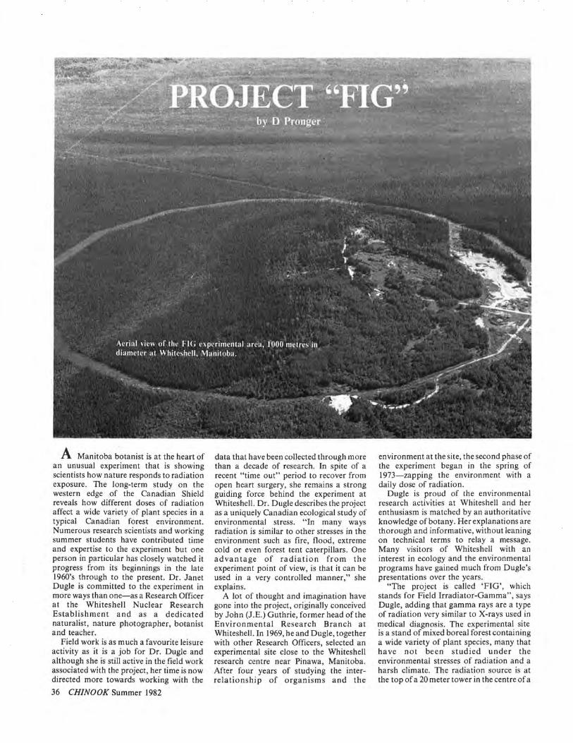
A Manitoba botanist is at the heart of an unusual experiment that is showing scientists how nature responds to radiation exposure. The long-term study on the western edge of the Canadian Shield reveals how different doses of radiation affect a wide variety of plant species in a typical Canadian forest environment. Numerous research scientists and working summer students have contributed time and expertise to the experiment but one person in particular has closely watched it progress from its beginnings in the late 1960's through to the present. Dr. Janet Dugle is committed to the experiment in more ways than one-as a Research Officer at the Whites hell Nuclear Research Establishment and as a dedicated naturalist, nature photographer, botanist and teacher.
Field work is as much a favourite leisure activity as it is a job for Dr. Dugle and although she is still active in the field work associated with the project, her time is now directed more towards working with the
36 CHINOOK Summer 1982
data that have been collected through more than a decade of research. In spite of a recent "time out" period to recover from open heart surgery, she remains a strong guiding force behind the experiment at Whiteshell . Dr. Dugle describes the project as a uniquely Canadian ecological study of environmental stress. "In many ways radiation is similar to other stresses in the environment such as fire, flood, extreme cold or even forest tent caterpillars. One advantage of radiation from the experiment point of view, is that it can be used in a very controlled manner," she explains.
A lot of thought and imagination have gone into the project, originally conceived by John (J.E.) Guthrie, former head of the Environmental Research Branch at Whiteshell. In 1969, he and Dugle, together with other Research Officers, selected an experimental site close to the Whiteshell research centre near Pinawa, Manitoba. After four years of studying the interrelationship of organisms and the
environment at the site, the second phase of the experiment began in the spring of 1973-zapping the environment with a daily dose of radiation.
Dugle is proud of the environmental research activities at Whites hell and her enthusiasm is matched by an authoritative knowledge of botany. Her explanations are thorough and informative, without leaning on technical terms to relay a message. Many visitors of Whiteshell with an interest in ecology and the environmental programs have gained much from Dugle's presentations over the years.
"The project is called 'FIG', which stands for Field Irradiator-Gamma" , says Dugle, adding that gamma rays are a type of radiation very similar to X-rays used in medical diagnosis. The experimental site is a stand of mixed boreal forest containing a wide variety of plant species, many that have not been studied under the environmental stresses of radiation and a harsh climate. The radiation source is at the top of a 20 meter tower in the centre of a

Jan Dugle with two of this year's group of summer students, Joanne Williams from Pinawa and Pam Worona from Lac du bonnet (left to right). Behind them is the base of the irradiation tower where the radioactive source is contained when not in use.
circular plot of land, 1000 meters in diameter, isolated by a high fence and a firebreak. To allow safe access to the area for the many measurements and observations needed, the radiation field can be eliminated by lowering the source by remote control into a shielded container.
"We irradiate the area on an average of 19 hours per day," Dugle explained. "The dose ranges from about 450,000 times background level near the irradiator, to about 25 times background near the fence, 500 metres from the source."
The background level is a level of exposure to radiation that everyone, including the environment, receives, from the cosmic rays of outer space, and from naturally occuring elements in the soil, rocks and air.
Dugle makes a point of emphasizing that radiation can alter living organisms on the cellular level without converting them to radioactive substances themselves. "Gamma radiation is similar to X-rays as used by your doctor; the radiation is helpful in diagnosing broken bones or disease, yet doesn't leave any part of our bodies radioactive," she says.
A very visible example of the irradiated but not radioactive concept is the unusually large number of berry plants in the FIG area. "The raspberries and stawberries grow larger and tastier and a little faster than normal," says Dugle, "and after several years of gamma' radiation, wild raspberries have gradually become dominant in many areas where all other shrubs have been killed. After exposure to extremely high dose rates for 59,000 hours
(nearly seven years) the raspberry survives and spreads. The wild rose is another common plant that is comparatively radiation resistant in terms of survival but displays the effects of high doses of radiation in its structure and form. It often shows enlarged leaves, red-purple colouring in the leaves or an increased number of flowers," says Dugle.
"We are trying to determine the lowest level of radiation exposure at which changes in various plant species or in the inter-relationships of plants and environmental factors can be detected.
"As expected, in the FIG area the changes at high dose rates have been quite dramatic, with many trees killed and the appearance of a very different assortment of ground cover plants from those originally recorded. However ecological changes are much more subtle at lower dose rates," says Dugle. "Although there are many exceptions , some generalizations about the effects of radiation on terrestial plants and plant associations can be made; for example, plant associations characteristic of harsh environments and climatic extremes tend to be comparatively resistant to radiation. Our research suggests that within the plant kingdom the order of radiation sensitivity from most to least sensitive is trees, shrubs, herbs, fungi and lichens. "
The FIG project is time-consuming, requiring many hours to identify and count over 100 different species of plants found in plots studied every summer. Some of the first-year university students who return home for the summer to nearby Pinawa, Beausejour or Lac du Bonnet are employed at Whiteshell to work on the FIG project. Each spring Janet Dugle has introduced a new group of eager learners to their summer field work and the ecology of eastern Manitoba. Students may choose their own special projects, leading to some interesting discoveries. Two students identified a new species of plantain for the area as part of a study of wild edible plants while another student discovered a fern not found before in Manitoba.
As an instructor at several universities in the past, as far distant as Yale in Connecticut and the University of Alberta in Edmonton, Dugle has gained a professional approach to teaching and maintains this interest as an Adjunct Professor in the Botany Department at the University of Manitoba. She knows the value of the controlled experimental area at Whiteshell and has aided many students in thesis work and professors with research experiments.
"In the early days, ten or twelve years ago, we had to learn as we went along; much of what we were doing had never been done before. Taking measurements of
radiation levels at over 2000 locations is one area of expertise we gained through experience. We first had to learn how to deal with such things as squirrels chewing on the dosimeters or finding the dosimeter packages saturated with water after a heavy rainfall." The dosimeter referred to by Dugle is a small device used for measuring radiation dose.
Dugle is now so well acquainted with the effects of radiation at different levels of exposure she can tell what the dose is at a particular location by examining the plant life. The idea of determining radiation exposure by noting the changes in certain plant species- using biological dosimeters -is an area of research that is being tested in the U.S.A.
The research findings for the FIG experiment have been documented by Dugle and her colleagues at Whiteshell in many publications including technical papers for several scientific journals and reports issued by Atomic Energy of Canada Limited. One of the more recent reports and of particular interest to any naturalist, is a l20-page report containing detailed descriptions and line drawings of shrubs common to Manitoba, all of them found in or near the FIG area. The publication also includes an illustrated glossary of botanical terms.
The experiment will not end by simply deciding to stop irradiating, but, following the irradiation phase, a number of years of study and evaluation will document the changes that take place in the plant community with the return to background radiation levels.
The summer of' 82 will be the tenth year of irradiation and once again Janet Dugle will be there, ready for the surprises, the unexpected discoveries that make the project such an exciting one for her.
There are marshy areas within the FIG area where hybrid cattails are under study.
37

SUMMER OF '82 WAS COLD Statistics released by the Canadian
Climate Centre of Environment Canada indicate that few people will remember the summer of 1982 for its favourable agricultural and vacation weather. The early portion of the summer was warm in British Columbia and Alberta but June was a very cold month from Manitoba to Newfoundland. July brought near normal temperatures across all of southern Canada, but without any real hot spells; August was again cold across the country.
Overall the three month summer period was slightly cooler than normal in most of Canada, although parts of the Prairies had slightly above normal summer temperatures. Southern Ontario, however, experienced its coldest summer since 1929. In Toronto the highest temperature this summer was 30 degrees C, the lowest such maximum value in a century.
During the early part of the summer, the warmer than normal temperatures and much less than normal precipitation were factors in the occurence of severe forest fires in northern British Columbia and Alberta, in the Yukon and in the Mackenzie District. Later, in southern British Columbia, wet dull weather caused problems for cherry growers and farmers . Across the Prairies there was an unusually high incidence of severe weather with heavy rains, hail, funnel clouds and tornadoes in July and August. During the last week of August heavy frost in the northern agricultural areas of the Prairie Provinces produced severe damage to cereal crops while in southern Ontario and Quebec a large portion of what had been an excellent tobacco crop was destroyed by frost. SCIENTISTS MONITOR VOLCANIC CLOUDS
Two geophysical events have captured the interests of scientists with the Atmospheric Environment Service of Environment Canada. The first, a mysterious volcanic cloud was first noticed in February, floating in the stratosphere. Then in the spring the greatest geophysical event of the last 70 years occurred - the eruption of the EI Chichon volcano in Mexico.
A new instrument, developed by scientists with the Atmospheric Environment Service of Environment Canada, has put them in the forefront of research on the volcanic clouds which are now circling the globe in a very broad band between the tip of Brazil and Alaska (from 10 degrees south to 60 degrees north). The instrument, the Brewer spectrophotometer, records atmospheric ozone and S02 by measuring
38 CHINOOK Summer 1982
the intensity of light in the ultraviolet absorption spectrum of the two gases. It is far more accurate than the Dobson instrument (currently in standard use) and is also lightweight, portable and requires only lI01220V AC to operate. Brewer spectrophotometers have been used to monitor volcanic clouds in Jamaica, Wyoming and Hawaii.
The mystery cloud, which scientists speculate came from a South Pacific volcanic eruption in late December or early January, 1982 was monitored by the AES Brewer Spectrophotometer on March 13, 1982 as it diffused over Toronto. A level of S02 of 40 ppmm* was recorded. The average S02 background for Toronto is 5.0 ppmm at these upper levels of the atmosphere.
The main high-altitude EI Chichon cloud which bands the equator is 25 km. in altitude. The low altitude 18 km EI Chichon cloud hovers over Canada. AES scientists expect the main cloud to diffuse northwards from its present location and spread out over the next few months .
The EI Chichon volcanic cloud has been monitored by AES since its eruption in April with Brewer Spectrophotometers in Canada, in NASA research aircraft and at the National Oceanic and Atmospheric Administration (NOAA) of the United States research site at Mauna Loa, Hawaii shortly after the eruption. In Hawaii the US scientists recorded S02 concentrations of 100 ppmm to 160 ppmm. AES scientists first detected the EI Chichon cloud over Toronto in late June, when the measurements of S02 in the stratosphere jumped from about 40 to 90 ppmm. Since then the S02 levels in these upper layers of the atmosphere above Toronto have fluctuated between 60 ppmm and 120 ppmm - indicating that the cloud may be moving back and forth over Toronto, possibly following the jetstream.
Measurements of the direct solar beam over Toronto have shown a reduction of 10%. However, scattering of this radiation by the volcanic cloud, provides the earth's surface with an increased diffuse radiation of 8%. The resulting net total solar radiation is thus reduced by 2%. Similar measurements made under the thick portion of the cloud in Hawaii have indicated a reduction of the direct solar beam of 25%, and a reduction in the net total solar radiation of 5%.
The EI Chichon volcano released 50 megatons of S02 straight into the atmosphere with the force of a nuclear blast. Mt. St. Helen's volcano, in comparison, exploded sideways, spewing
volcanic ash and S02 much closer to ground level.
The El Chichon cloud is composed of volcanic dust from 15 to 20 km. altitude and S02 from 15 to 40 km. altitude. U2 pilots who regularly fly through the cloud describe it as "like a thick, grey fog". Scientists estimate the cloud is almost 10 km. thick, on average. It can be seen on commercial jet flights as a red-purple mass hovering above the horizon, or from ground level as a halo around the sun.
... part per million metres.
HISTORICAL NAMES GIVEN TO LABORATORIES
The names of Canadian historical figures have been given to the central research facilities of two regions of the Ocean Science and Surveys Sector of the department of Fisheries and Oceans.
The Bayfield Laboratory for Marine Science and Surveys, in Burlington, Ont., the nucleus of the Central Region, has been named for Admiral Henry Wolsey Bayfield, the major figure in hydrography in preConfederation Canada. The Champlain Centre for Marine Science and Surveys in Quebec City, headquarters of the Quebec Region, has been named for Samuel de Champlain, the "father of New France" .
The names were chosen as a tribute to the contributions made by these two important historical figures and to provide a focus for Ocean Science and Surveys activities in the regions. Recent work in the Quebec Region includes studies on the distribution of mercury and other trace metals in the water and ecosystems of the Saguenay fjord and effects of hydroelectric developments on the marine environment of the Gulf of St. Lawrence. In the Central Region recent projects have concentrated on high Arctic hydrography and ocean current regimes in Arctic Islands.
From 1816 to 1856 Admiral Bayfield charted practically the entire shoreline from Lake Superior to the Atlantic Ocean. His charts and sailing directions guided many ships from the Great Lakes to the Gulf of St. Lawrence for more than 50 years. The Canadian Hydrographic Service has traditionally named one of its vessels in Admiral Bayfield's honour, starting with a tugboat bought in 1884. Today one of the survey research vessels operating in the Great Lakes is named C.S.S. Bayfield.
Samuel de Champlain was an explorer, cartographer, colonizer, writer and the founder of Quebec. Among his numerous achievements, he explored the St. Lawrence and Ottawa Rivers, Lake Huron, Lake Champlain, and mapped many harbours along the Atlantic coast.

POLLUTANTS HANDBOOK OF AGRICULTURAL AND FOREST METEOROLOGY. Edited by Dr. R.A . Treidl, Canadian Climate Centre, Environment Canada, 1982. In 3 volumes. Total cost $44. 1,800 pages. Available/rom Canada Department 0/ Supplies and Services, Government Publishing Centre, Hull, P.Q. KIA OS9.
The Atmospheric Environment Service, Environment Canada, in collaboration with noted Canadian experts in the fields of agriculture and forestry has produced a data collection tailored to serve the special requirements of farmers and foresters for climatological information and data.
In the three volumes users can find information, in two official languages, on the AES and its organization, on how to obtain forecasts and specialized services. Moreover they can obtain information on the environment-plant relationships for a wide range of crop and forest tree species.
In addition there are 37 tables with climatological information for up to 250 stations within Canadian agricultural and forest regions. Temperature and precipitation are covered in special detail, extremes and means for periods from one week to the entire year, probabilities of those elements to exceed or stay below certain critical thresholds. Other important yardsticks include growing degree-day and corn heat unit normals for zonation of crops; statistics relating to soil temperatures and snow cover; sunshine and solar radiation; durations of dry and moist periods; hail and thunderstorm days; growing season statistics, Markov probabilities, hay drying support data; the probabilities for good spraying conditions; cloud cover and wind data. In short, much of the climate data, that the farmer or forester is liable to need for his numerous chores and tasks throughout the year, are included in the book in such a way that he not only gets the average conditions but also an idea of the limits of variability, the worst that can happen or has happened during the station's record period.
"They're anti-litter leaflets"
ATMOSPHERE-OCEAN The scientific journal of international meteorological and oceanographic research. Quarterly publication plus a special Congress issue.
CMOS NEWSLETIER Keeps you in touch with the activities of the Canadian Meteorological and Oceanographic Society. Six times per year.
CLIMATOLOGICAL BULLETIN Climatological research and news. Twice yearly.
These publications are all available from CMOS/SCMO, Suite 805, 151 Slater St., Ottawa, Ontario, Canada. KIP 5H3. AtmosphereOcean and the Newsletter are included with membership in the Society (write for details). The Climatological Bulletin subscription rate is $10 per year.
Please enter my subscription to CHINOOK for 0 one year ( 4 issues) $ 7.50
Rates outside Canada and U.S. 1 yr. $9.00
Name ____________________________________________________ ___ please print
Addr~ss __________________________________________________ ___
_ __________________________________ Enclosed is $, ____ _ Postal Code
Mail to CHINOOK, P.O.Box 427, Brampton, Onto L6V 2L4. This is a 0 NEW order; a Osubscription RENEWAL
L _________________ ____ _______ ~
39

40 CHINOOK Summer 1982

Facing Page. A famous waterspout off the Costa Brava, Spain on September 2, 1965. Above. A waterspout in Saskatchewan, 1925. Below. One of the stages of a waterspout near Point Pelee, Lake Erie on September 12,1982.
Courtesy W. T. McShane
WATERSPOUTS A PHOTO FEATURE
Waterspouts are a common phenomenon in Canada. They are seen at one time or another on all bodies of water, whether the surrounding oceans east and west, or inland lakes large and small. They have been seen in arctic areas as well as at more southerly latitudes. The first waterspout report in this country was by Captain Cook on May 17, 1763 who saw 6 of them on Queen Charlotte Sound, British Columbia. He said that in one of them a bird was seen, and in arising it was "drawn in by force and turned around as if on a spit".
A tendency for waterspouts to form in families, sometimes numbering as many as 9 or 10 at a time, has often been observed. They are most common in the late summer and fall of the year, and are formed under different circumstances than tornadoes which of course they resemble in appearance. Their behaviour is characterized by a tendency to dissipate rather quickly once they leave the sustaining marine environment. They will sometimes cause damage upon making landfall but this is not very common.
Courtesy Steve Leitch
Above. A waterspout on Lake Erie about 5 to 7 km south of Long Point, Ontario, September 17, 1981. Below. Another stage of the Point Pelee waterspout of September 12, 1982.
Courtesy W. T McShane 41

Photo courfesy Ontario Hydro
Hurricane Hazel in 1954 caused the Holland River 10 overflow its banks. This was the scene just west of Highway 400 in the Holland Marsh area just after the storm.
Each and every year a few score of Canadians die as a result of the more extreme modes of weather behaviour across the country. Furthermore, the safety of many others is put at risk and disruption is caused in many sensitive economic sectors such as agriculture, the delivery of supplies and services, and communications . Both large and small, emergencies caused by weather are a frequent occurrence in Canada (a meteorological emergency is broadly defined here as a situation in which the weather causes unexpected circumstances requiring immediate or unusual remedial action). Books can be written about each one of the various types of such emergencies, so the purpose of this short article is simply to outline the nature of the problem and its effects in Canada, and to compare a few historical examples .
A general approach suggests that only a few meteorological events are responsible for most meteorological hazards. Table I lists the events, namely (a) cyclone; (b) tropical storm; (c) severe thunderstorm or tornado; (d) cold outbreak; (e) heat and drought; (f) spring thaw. The hazards which result from the dynamic events
42 CHINOOK Summer 1982
(a,b,c) are similar in some respects because all can produce strong winds and high rates of rainfall, but major differences exist in their seasonal occurrence, natural habitat, their duration and areal coverage . Typically, emergencies under these circumstances arise quickly and are often dramatic . In the case of the climatological events (d,e,f) the onset of the emergency is often very gradual (as in the case of a drought) with no clearly defined beginning. History has shown that emergencies due to this category of events are the most severe.
It is important to remember that nonmeteorological factors very frequently play an important role in the creation of an emergency situation. In the case of landslides and avalanches for example, the slope of the mountain and seismic conditions are very critical considerations. Soil erosion depends upon land-use practices as well as upon the weather. Construction standards and methods which vary with time and place, determine to a large extent the severity of damage caused by strong winds. During the spring thaw, the flooding of river valleys (given similar meteorological conditions throughout a wide geographical area) is dependent
upon the topographical characteristics of the basin and its watershed. Further complicating the picture is the fact that several meteorological factors commonly combine to bring about an emergency situation. Wind-driven hail, for example, is far more devastating than hail alone. During a freezing rain storm it is often the effects of the wind which will break down ice-loaded trees, and cause ice-encrusted wires to snap. Pre-existing conditions, such as soil moisture content, are critical controls over the extent of forest fires, floods, or crop failures during times of precipitation and/ or temperature extremes An example of such a situation occurred during the extremely hot and dry period of the mid-1930's. In July and August of 1937, no measurable rain fell in Saskatchewan. It was a period of hydrological drought by any definition , and yet 20 bushels of wheat to the acre were harvested (compared to an average of 25 bushels/acre in recent years). The hydrological drought did not correspond to an agricultural drought because an adequate supply of moisture was received during the important spring seeding and growing season.

One way of determining the set of meteorological conditions which have the potential of causing emergency situations, is to establish threshold values. Such values are shown in Table 1 (page 44) and simply indicate a minimum value above which problems are possible. Those which are shown are most unlikely to apply in every location across the country, indeed it is not possible to obtain a value which is generally applicable. Even in the apparently simple case of freezing temperatures , different crops can tolerate varying degrees of frost. However, the numbers shown at least give an idea of the magnitude that a hazard must often reach before an emergency is likely. If threshold values are determined to suit individual geographical locations and peculiarities, then climatological data can be used to calculate their return period. The preparation of an atlas of Canadian meteorological hazards, their threshold values and return periods, is a research opportunity which awaits.
The types of emergency situation contained in Table 1 can be categorized according to their effect upon the economy. Six economic sectors (Table 2) appear to take the brunt of the disruptions caused by the weather. If they are sorted into the season when emergencies are likely to occur, it becomes clear that spring is potentially the most hostile time of year, followed closely by the winter months .
Emergencies precipitated by meteorological events are probably the most disruptive of any that can be expected in Canada. A comparison of the effects of the 1912 Regina Tornado, the 1936-37 Drought, the 1950 Red River Flood, and Hurricane Hazel in 1954 is presented in
Figure 1. This figure indicates the way in which per capita costs and losses due to a disaster cascade through a popUlation group from large individual losses suffered directly by a few individuals, to small losses (donations, taxes) suffered indirectly by a much larger number of individuals. Values placed on a human life ($300,000) and the cost of an injury ($10,000) were obtained from White and Haas, 1975. Estimates of the cost of property loss have been adjusted to a 1971 dollar = 1. While the values used are debatable, Figure I at least serves to indicate the order of magnitude of each disaster. It shows that the 1930's Drought and the Red River Flood were about equal in the magnitude of their economic disruption and top the list of worst meteorological disasters. The drought should perhaps be considered the worst because over 600 deaths can be attributed to it, while none are known to have occurred in the flood. Following, in third place and an order of magnitude behind, is Hazel, while the Regina Tornado is yet another order of magnitude lower. The Haileybury Fire of 1922, although not shown for the sake of simplicity, ranks about equal with Hazel.
It can be imagined that Figure I contains a spectrum of ranges which include other types of disasters. If they occurred in Canada, severe volcanic eruptions and severe earthquakes would likely be in the range furthest to the right of the figure (i.e. the worst), with other disasters such as bridge collapses, dance-hall fires, and ship explosions in a range to the left of the meteorological set.
What of the future? Climatological history is an indicator of what it may hold, but at any time nature could produce a new
record snowfall, exceed the strongest wind previously known or go to any other number of extremes. Who knows what would happen if a major tornado were to hit a city such as Toronto or Montreal, or a full fledged major hurricane were to slam into the Maritime provinces. Furthermore the ground rules frequently change. In the case of the Haileybury Fire for example, the proximity of the forest and the lack of a cleared zone around the town were major factors responsible for the spread of the forest fire into the town itself. Today such factors no longer exist, but in their place new areas of concern have arisen. Holding basins for toxic industrial substances and wastes are a case in point. It is easy to conjecture "worst case" meteorological circumstances which could cause dangerous, perhaps catastrophic, leaching or spilling of contaminants even though specific climatological statistics for the area indicated a safety margin. A prudent reaction might be to build a retaining wall of sufficient capacity to contain the spillover or leakage projected by the "worst case" scenario .
Of one thing there can be no doubt, meteorologically caused emergencies and disasters will continue from time to time. There is also no doubt that considerable research opportunities exist in this field, and that the fruits of such work could help to reduce the impact of meteorological hazards .
FURTHER READING: Gilbert T. White, and J. Eugene Haas ,
1975: Assessment of Research on Natural Hazards. MIT Press, Cambridge Massachusetts, and London England.
-?(C) 1-(;. /J!~/~¢ o~ 'P-?" ... ¢ -?/J..
A A A = Agriculture C C C = Communications T T T = Travel S S S S = Supplies & Services H H H H H = Housing & Shelter R R R R R = Resources
W SP S F
Season
TABLE 2. Seasonal disruptions to the economy are greatest in the spring when all sectors of the eco nomy are most affected.
'-I ),0., '?o «'-? 0"'«- <:0 ...
10' '?", 1- 01-.>-<'0 "7¢"'~ 0<)
o <'( 0", /J>
10' :JQ
0
--' 104
-
o/l
~ u 10'
j9 a == dead .~
10' b = injured u c == disloca ted
"- d = damaged
10' e == disturbed r == donors g == ta xed g
10'
10' 10' 10' 10' ll)' 10' 10' 10'
Population Affected
FIGURE 1. When the disruptive effects of various events are compared. the 1930's drought should be considered the most disastrous natural calamity in Canada.
43

METEOROLOGiCAlI HAZARD
I
COMMON EMERGENCY
I
EMERGENCY I T,"CAL I HAZARO I SEASONA' I
HAZARD EVENT SITUATIONS LOCATIONS AREAL DURATION OCCURRENCE TRESHOLD
EXTENT wlnlar IWI. spring ISPI. VALUES 'Q KM summar lSI. 1,1\ IFI
CYCLONE WINO Structural Building Damage Canda-Wide 104 Hours or W, SP, F (a) 55 kmh Inundation of Shorelines by Lk. Winnipeg 101 Days F, SP
High Water and/or Ice Great Lakes Shipwrecks Marine Area 1(}4 W, SP, F Personal Injury-Loss of Life Canada-Wide W. SP, F Oil Spills Marine Area 104 W. SP. F
HEAVY RAIN Flooding of Agricultural and Valleys and 102 Hours or Mainly SP (a) 40mm/12hr Residential Areas Lowland Days
Landslides Mountainous 101 SP, F Areas
FREEZING Widespread Power Failures and Mainly Ern. 104 Hours or W (a) 12mm/12hr RAIN Communication Disruption Canada Days
Travel Disruption-Accidents Mainly Ern. 104 W (a) lmm/hr. Canada
BLIZZARD Loss of Life Canada-Wide Hours or W (a) Wind 50kmh {Combination (except the Days and of Wind & Travel Disruption-Accidents Pacific Cst.) 105 (Rarely W Windchill of COld) Weeks) 1625 Watts/m 2
Disruption of Supplies-Services 105 W HEAVY Travel Disruption-Accidents Canada-Wide 105 Hours or W (a) 15cm SNOW Days
Disruption of Supplies-Services 105 W
Avalanche Mountainous 101 SP Areas
HURRICANE WINO (See Cyclone) Ern. Canada 104 Hours or Late S, F (See Cyclone) Days
HEAVY RAIN (See Cyclone) Ern. Canada 102 Late S, F SEVERE WINO Structural Building Damage Canada-Wide 100 Minutes Late SP, S, (a) Gusts of
THUNOER- or Hours Early F 80 kmh STORMS
OR TORNADO Crop and Forest Damage 100
Injuries and Loss of Life HEAVY RAIN (See Cyclone) Canada-Wide 102 Minutes Late SP, S, (a) 25mm/hr
or Hours Early F HAIL Property and Crop Damage Canada-Wide 102 Minutes Late SP, S (a) 10mm
or Hours Early F Diameter LIGHTNING Forest Fires Canada-Wide 103 Seconds Late SP, S,
Early F Injuries and Loss of Life
Property Fires 10-3
Power Distribution 10-3
COLO FROST Crop Damage Canada-Wide 104 Hours or SP, F ODC OUTBREAK Days
Loss of Life (Exposure) Canada-Wide W HEAT AND Loss of Life (Heat stroke) Canada-Wide Weeks Of S (a) 15 Days No DROUGHT Months Rain
Crop Failure Canada-Wide 106 (Rarely SP,S (b) le~s Than Years) 60% of Normal
Water Shortage and Quality Canada-Wide 106 SP,S, F Precipitation From Nov. 1 to
Forest Fires Canada-Wide 103 SP, S, F May 31 Soil Erosion Canada-Wide 106 SP.S. F
SPRING FLOODS Inundation of Farm and Canada-Wide 103 Days or SP (cl Basin-& ICE JAMS Residential Areas Weeks Dependant but
Travel Disruption Canada-Wide 103 SP Typically 25mm Disruption of Supplies-Services Canada-Wide 103 SP Runoff f24 hrs
TABLE 1. A listing of meteorological events, the hazards which they produce, and emergency situations which commonly result.
44 CHINOOK Summer 1982

SUCCESSFUL TECHNOLOGY TRANSFER BETWEEN GOVERNMENT AND INDUSTRY
There are many discussions these days about government spending on research and development of technology. It is an area which the government can not successfully carry to commercial end without the input of the electronics industry . A recent important example of a government agency working with industry was the sale and operation of a sophisticated weather radar system to Brazil by a Canadian manufacturer.
Athabasca Research Corporation and the Alberta Research Council's Atmospheric Sciences Department have been collaborating for the past several years and have produced one of the most advanced weather radar systems in the world. The Digital Radar Data Processing System was originally developed as a tool for the Council's Alberta Hail Project and is now being marketed through the Athabasca Research Corporation. Ed Adams (Chinook, Spring 1980) stated that without the original scientific research development by the Council, his company would not necessarily have become involved with weather radar. On the other hand, Dr. Brian Barge, the Head of the Atmospheric Sciences Department said that the Council, by itself, was not capable of pursuing the marketing aspects, nor the full scale production of the unit. The association with Athabasca Research was vital.
Dr. Gilles Cloutier, President of the Alberta Research Council, says the
NEW PRODUCTS
technology transfer to Athabasca Research Corporation represents a fulfilment of one of the Council's objectives of promoting responsible economic development in the province through applied science. "We are confident that this arrangement will give other Alberta companies the incentive to enter the fi eld of high technology since the marketing possibilities for a system like this are plentiful. " Dr. Barge added, "This story began almost 30 years ago when the Alberta Research Council played a small part in a na tional project o n weather radar in conjunction with the National Research Council, McGill University and the Canadian Atmospheric Environment Service. It has taken time, but we have developed a highly sophisticated system that is both unique and highly practical."
The system provides the capability to collect, analyse, archive and present digital weather radar data. Data is stored on computer tapes and can be retrieved for analysis using elementary computer commands. It appears on a screen in graphic or pictorial form . The system is also equipped with a focusing and magnifying capability for in-depth analysis of particular cloud formations. The Digital Radar Processing System has broad applications in weather modification , hydrology, meteorology , forestry and agriculture. It also has an important application in flo od prevention, since it can provide warning of heavy rainfalls which
will affect fl ood plains, or dam reservoirs. Brazi l, wh ere the system has been operating for over a year, is using it to forecast water levels behind the dams of its many hydroelectric power generation plants.
Under the agreement signed between the Alberta Research Council and Athabasca Research, the Council will receive a small percentage of sales, somewhat similar to royalty payments. The actual transfer of technology was not a "one time only exchange" , but as the research and techn ology advances so will the radar system. Dr. Adams says a transfer of technology of this type is beneficial to both the scientific developers and the commercial enterprise. "Since we joined the Brazil project in 1978 as hardware manufacturers, Athabasca Research has made a substantial investment in both dollars and manpower. We are confident that the system has vast commercial potential in Canada and abroad. This is an excellent example of pure research transformed to applied science." Dr. Barge adds that: "As an example, one American radar manufacturer recently took an order for about 100 weather radar units. Wherever a weather radar unit is installed, potential exists for use of the processing system. Canada is two years ahead of the world in this technology, so it's highly possible th ose countries looking to improve their systems will consult with Canadian experts."
SONIC ANEMOMETER The Campbell Scientific CA27 Sonic Anemometer (left) was
built to measure vertical wind. The accoustical path length is 10 cm. The anemometer also comes with a fine wire chromelconstantan thermocouple . Both wind speed and thermocouple circuitry is housed in the base. An analogsignal is output for each parameter. Current drain is 4 ma; wind signal calibration is 1 Volt per m/s and the range is ± 4.0 Volts . For more information contact Campbell Scientific Canada Corp. 10429 87 Ave., Edmonton, Alberta, T6E 2P4. Tel. (403) 439-2771.
Note: Shown in photo with Lyman-Alpha hygrometer as part of a flux measuring system.
MINI-HEATER The heating system and enclosure (shown next page) transfers
the infra-red heat produced by the Cata-Dyne Mini-Heater into the extra-insulated cooler by means of an absorption plate attached to a superconductor. A temperature rise of over 110°F can be maintained in the cooler at 600 B.T.U. per hour fuel
Continued p. 46
45
consumption and a temperature rise of 20°F at 175 B.T.U. per hour fuel consumption. With a cooler thermostat setting of 65°F, the projected fuel consumption for one year in Edmonton is approximately 150 Ibs. of propane. Cooler capacity is approximately two cubic feet. The cooler can be sealed to prevent moisture or dust from entering. This system can be scaled up for larger enclosures. Uses; heating system for instrumentation, scientific apparatus, computer components, telemetering equipment or any similar application. Cis Can Sales (Western) Ltd, 3880-74 Ave., Edmonton, Alberta, T6B 2P7. Tel. (403) 466-3178.
AERATION SYSTEMS INCREASE FISH NUMBERS, SIZE
By taking advantage of a considerable amount of specialized oxygenation research, testing and installation experience-and not just blowing air into bodies of water-a Canadian company is helping improve fishing in many areas of the nation.
Hydraulic engineers working for Hinde Manufacturing, Hamilton, Ontario, have developed a system of low-turbulent aeration which carries a continuous supply of oxygen throughout a water mass. The result is that fish can live at all depths and in every corner of a pond or lake.
Inquiries are invited. Contact Fish Aeration Department, Hinde Manufacturing, 260 Burlington Street East, Hamilton, Ontario L8L 4H4. Phone: 416-529-7515.
46 CHINOOK Summer 1982
VOLUME FOUR INDEX A lis/ of Au/hors. ar/ic/es and adver/isers in Chinook, volume 4. numbers I /0 4. An as/erisk
(*)indica/es a column which appears regularly. If the au/horship of an ar/ic/e is not shown. it is by /he Edi/or.
AUTHORS Chen, Peter. Les Pyrocumulus. Page 9. Chung, Y.S. Roadside Air Pollution. Page 4 Hage, H.D. The Kelvington Tornado of 1973. Page 27. Labine, c. Successful Technology Transfer between Government and Industry. Page 45. Leduc, Richard. Climat et Environnement. Page 8. Newark, Michael J. Meteorological Hazards. Page 42. Pronger, D. Project "FIG". Page 36. Siok, Stanislaus. La Prevision et la Detection du temps violents au Quebec. Page 24. Somerville, Scott. Heat and Drought, 1930's Style. Page 10. Somerville, Scott, M.I. C. Company and Baker Instruments. Page 13. Strong, G.S. Hailstorms!-Why Alberta. Page 21.
ARTICLES Hailstorms!-Why Alberta, by G.S. Strong, page 21. Heat and Drought, 1930's Style, by Scott Somerville , page 10. Kelvington Tornado of 1973, The, by K.D. Hage, page 27. Meteorological Hazards, by Michael 1. Newark, page 42. Project "FIG", by D. Pronger, page 36. Roadside Air Pollution, by Y.S. Chung, page 4. Salute to the Weather Amateur, page 6. Waterspouts-A Photo Feature, page 40.
BOOK REVIEW* Handbook of Agricultural alld Forest Meteorology, Summer 1982, p. 39.
NEWS AND NOTES* Easier Passage to the North, Autumn 1981, p. 12. Historical Names Given to Laboratories, Summer 1982, p. 38. Nazi Weather Station on Labrador Coast, Autumn 1981, p . 12. Pollutants Continue to Plague Hamilton Harbour, Summer 1982, p. 35. Scientists Monitor Volcanic Clouds, Summer 1982, p. 38. Sixteenth Annual Congress, CMOS, Autumn 1981, p. 12. Summer of '82 was cold, Summer 1982, p. 38.
SECTION FRANCAISE* Climat et Environnement, par Richard Leduc, Automne 1981 , p. 8. Le Prevision et la detection du temps violent au Quebec, par Stanislaus Siok, Hiver/Printemps 1982, p. 24. Les Pyrocumulus, par Peter Chen, Automne 1981, p. 9.
TRADE WINDS* Chinook Visits Enercorp, Winter/ Spring 1982, p. 29. M.I.e. Company and Baker Instruments, by Scott Somerville, Autumn 1981, p. 13. Successful Technology Transfer between Government and Industry, Summer 1982, p. 45.
A Complete Meteorological Consulting Service with offices in Toronto, Calgary and Winnipeg
Real time forecasting on all scales for all areas of North America • Micro and Meso Meteorological Studies • Climatology • Air Pollution Meteorology • Agro Meteorology • Instrumentation For additional information contact
Meteorological and Environmental Planning Ltd. 850 MagnetiC Drive Downsview Ontario M3J 2C4 Phone (416) 661-5960 Telex 065-24747

Associations METEOROLOGY STUDY UNIT. Topical philately (weather and climate on stamps). Peter Robinson, Secretary MSU, 70 Pleasant St., Dedham, MA 02026 USA.
CANADIAN METEOROLOGICAL AND OCEANOGRAPHIC SOCIETY, Suite 805,151 Slater, Ottawa, Ont. KIP 5H3. (613) 237-3392.
Services FMC QUEBEC. English to French translation by professional meteorologists . Box 1304, Cap Rouge, P.Q. GOA lKO.
Consultants ACCU-WEATHER,® INC.
Sen ing Canadian and L·.S. Clients
JOEL N. ~IYERS. PH.D .• PRESIDENT ELLIOT ABRAMS. ~.S .. SR. VICE-PRESIDEIXT JOSEPH P. SOBEL. PH.D .. \'ICE-PRESIDDIT 't\'AN MYERS. VICE-PRESIDENT
Weather Forecasting . Climatological Data and Surveys . Specialized Weather Information . Two Decades of Service to Business, Government, and the Professions . Expert Testimony
619 West COllege Avenue State COllege, Pa. 16801
PHONE 814-237-0309 TWX 510-670-3525
CLIMATOLOGICAL CONSULTING CORPORATION. Box 9306, Asheville, NC 28815. (705) 298-4237.
envirocon Environmental Research and Engineering Consultants 300-475 West Georgia Street, Vancouver, B.C., Canada V6B 4M9 (604) 687-7588 Telex: 04-53476
• Air Management Planning • Meteorological Surveys • Climatological Assessments • Ambient Air Quality
Monitoring
offices also located in:
• Dispersion Modelling • Source Testing • Licensing Guidance • Supplementary Control
Systems
• Calgary .Toronto. Montreal. Halifax. Seattle.
FORENSIC METEOROLOGY
WALTER F. ZELTMANN
INTERNATIONAL WEATHER CORPORATION 719 BAY RIDGE AVE BROOKLYN . NY 11220
APPLIED CLIMATOLOGY
12121748-8066
METEOROLOGICAL & ENVIRONMENTAL PLANNING LTD., 850 Magnetic Dr., Downsview, Ont. M3J 2C4. (416) 661-5960 Telex 065-24747. (See p. 46.)
WEATHER CONSULTANTS OF CANADA COMPANY LIMITED
65 Marlborough Ave ., Toronto, Ont. M5R 1 X5
Tel. (416) 968-7981
MORRIS KESTIN PRESIDENT
Weather Forecasts for Marketing-Advertising. Raulo, Television, Film, PulllicaLions
Research studies. COl1sultanrs /0 weather seilS/five IlIdus(nf!)' dVIMlO1/ /I{lllllt'S. a/ld flHlfIlCllhJlifl eS
Environment CAMPBELL SCIENTIFIC CANADA CORP. Consultant and Instrumentation. 1042987 Ave., Edmonton, Alta. T6E 2P4. (403) 439-2771.
Instruments Meteorological, Solar
Industrial and Laboratory Instruments
AIRFLOW DEVELOPMENTS (CANADA) LIMITED 1281 Matheson Blvd ., Mississauga, Ontario, Canada, L4W 1 R1
(416) 624-2133 Telex 06-960332
MITIOROlOGICAl INSTRUMINTS A complete range 01 instruments and systems to meet all your land based requirements. • Temperature and Humidity recorders. sensors, indicators,
transmitters • Thermometers, maximum and minimum (10 A,E S.
specifications) • Wind recorders and transmit1ers • Solar radialion and dUration instruments • Rain gauges, transmitters and recorders • Precipitation and evaporation recorders • Barographs and precision barometers • Complete weather stations • Compatible recorders, controllers and indicators
~~~I2t:f)I2V in~trument~ lId P.o. Box 20, Sin. "U", Toronlo, Onl. MHZ 5M4 (416) 231-5335
GEOTEST INSTRUMENT CORP., Ice and Snow Testing Instruments . Catalogue available. P.O. Box 551, Wheeling, IL 60090 (312) 459-0710. Telex 206175.
METEOROLOGICAL
HYDHOLOGICAL
SURVEY
INSTRUMENTS
(rulli1t) Sales - Service
weather Measure - Leupold I: Stevens - Gurley
Munro - Casella
Frederick Goertz Ltd. 1328 west Pender Street 505-1, 1110 Sheppard Ave. E. Vancouver , B.C. V6E 2W3 Willowdale, Ontario M2K 2W2
684-5.377 222-8167 Telex 04-508765 Telex 06-966575
M.I.C. COMPANY. Acid Rain Collectors, Data Acquisition Systems, Mini-sondes. 37 Maple Ave., Thornhill, Ont. UT 3S8 (416) 889-6653.
WHEN YOU REALLY NEEDTO KNOW THE WEATHER
Enercorp's complete line of meteorologicol instruments and calibration seNices provide the answer. We not only have sensors and transmitters but also compatib le recorders. indicators and controllers to tailor a system to your applications.
Q.;r Instruments measure. transmit or record temperature. relative humidity, dew point. barometric pressure. wind speed and dlreclion. sotar energy. intensity and dUration. rain. precipitation and evaporation. Maximum. minimum and adinol'{ glass thermometers calibroled in our lobs 10 AES (Almasphenc Enviranmenl $eNice) specifications o re being used in meteorological stations across Canada,
Service to most types of meteorological equipment with certification agolnst lraceoble standards. Is readily performed in our calibration and repair laboratories. Our technicians have over 30 years of meteorological instrument experience. Enercorp is a supplier to AES. provinCial governments, universities und industrial cuslamers ronging from oil refineries 10 aerospace firms.
FOR SERVICE TO YOUR PRESENT EQUIPMENT OR NEW INSTRUMENTATION, CALL US FOR PROMPT ACTION AT VERY REASONABLE PRICES.
~~~VC()VV instruments ltd P.O-. Box 20, Stn. "U", Toronto, Ont. MaZ 5M4 (416) 231·5335


![Plant Modeling and Performance Analysis of Electro ...€¦ · Plant Modeling Motor Dynamics [1] Gear Train Kinematics System Dynamics [2] Eq. (4) and (16) are solved simultaneously](https://static.fdocuments.in/doc/165x107/5f42920d32efa8693f20f55d/plant-modeling-and-performance-analysis-of-electro-plant-modeling-motor-dynamics.jpg)