Horseshoe West Fuels Reduction and Restoration...
35
Horseshoe West Fuels Reduction and Restoration Project Fire/Fuels Report Prepared by: Dave Riegle Fire/Fuels Specialist for: Seeley Lake Ranger District Lolo National Forest May 20, 2011
Transcript of Horseshoe West Fuels Reduction and Restoration...
Horseshoe West Fuels Reduction and Restoration Project
Fire/Fuels Report
Prepared by: Dave Riegle
Fire/Fuels Specialist
for: Seeley Lake Ranger District
Lolo National Forest
May 20, 2011

The U.S. Department of Agriculture (USDA) prohibits discrimination in all its programs and activities on the basis of race, color, national origin, age, disability, and where applicable, sex, marital status, familial status, parental status, religion, sexual orientation, genetic information, political beliefs, reprisal, or because all or part of an individual's income is derived from any public assistance program. (Not all prohibited bases apply to all programs.) Persons with disabilities who require alternative means for communication of program information (Braille, large print, audiotape, etc.) should contact USDA's TARGET Center at (202) 720-2600 (voice and TDD). To file a complaint of discrimination, write to USDA, Director, Office of Civil Rights, 1400 Independence Avenue, S.W., Washington, D.C. 20250-9410, or call (800) 795-3272 (voice) or (202) 720-6382 (TDD). USDA is an equal opportunity provider and employer.
Horseshoe West Fuels Reduction and Restoration Project
i
Table of Contents Introduction ................................................................................................................................. 1
Overview of Issues Addressed ................................................................................................ 1 Criteria Used For Analysis ...................................................................................................... 1 Methodology ........................................................................................................................... 2 Spatial and Temporal Context for Effects ............................................................................... 3 Design Features and Mitigation Measures .............................................................................. 3
Regulatory Direction ................................................................................................................... 4 Federal Policy .......................................................................................................................... 4 Forest Plan Direction ............................................................................................................... 5 Desired Condition .................................................................................................................... 6
Affected Environment ................................................................................................................. 6 Existing Condition ................................................................................................................... 6
Environmental Consequences ................................................................................................... 10 Alternative 1 – No Action ..................................................................................................... 10 Alternative 2 – Proposed Action ........................................................................................... 12
References ................................................................................................................................. 17 Appendix A: Seeley-Swan Risk Assessment Map .................................................................... 21 Appendix B: Horseshoe West Fire History Map ...................................................................... 22 Appendix C: Flammap Modeling Results ................................................................................. 23 Appendix D: Map of Horseshoe West Fuels Reduction and Surrounding Projects .................. 27 Appendix E: Fuels Treatment Science–Selected Discussions from Literature ......................... 28
List of Tables
Table 1. Fireline intensity interpretations ........................................................................................ 9 Table 2. Potential fire behavior characteristics ............................................................................. 10 Table 3. Alternative comparison of potential fire behavior characteristics expected within the
project area ............................................................................................................................ 13
List of Figures Map 1. Seeley-Swan risk assessment map .................................................................................... 21 Map 2. Horseshoe West fire history map ...................................................................................... 22 Map 3. Flammap model of flame length potential for the existing condition ............................... 23 Map 4. Flammap model of crown fire potential for the existing condition ................................... 24 Map 5. Flammap model of potential flame length after treatment ................................................ 25 Map 6. Flammap model of potential crown fire after treatment.................................................... 26 Map 7. Past, present, and reasonably foreseeable future projects ................................................. 27

Horseshoe West Fuels Reduction and Restoration Project
1
Introduction The Lolo National Forest (LNF) is proposing the Horseshoe West Fuels Reduction and Restoration Project (Horseshoe West Project) which is being planned to reduce hazardous fuels, restore vegetative conditions, and improve wildlife habitat on the Seeley Lake Ranger District. Land management activities proposed include: commercial and non-commercial vegetation management on approximately 3,149 acres to improve forest health, reduce fuels, and maintain or improve wildlife habitat.
The project area is located about 3 miles southeast of Seeley Lake, Montana, in sections 8, 9, 17−21, and 30, T16N, R14W; and sections 13, 24, and 25, T16N, R15W. It is located within the Seeley-Swan Wildland-urban Interface (WUI) and is adjacent to the Double Arrow and Big Sky Lake subdivisions (see appendix A maps). The project area contains approximately 5,100 acres of land that were acquired by the Forest in 2007 and are now managed for big game winter range and timber. The timber stands are dominated by Douglas-fir, lodgepole pine, western larch, and mixed conifer. Most of the lodgepole pine and ponderosa pine stands have been infested by mountain pine beetles.
This analysis describes the existing condition of the fire/fuels condition within the project area and discloses the potential effects of the alternatives on fuels conditions and fire behavior for consideration in determining whether or not to prepare an environmental impact statement.
Overview of Issues Addressed Prescribed fire following mechanical treatments: The proposed use of prescribed fire may not be necessary if the areas are treated mechanically.
This issue was considered by the IDT, but did not result in the development of additional project alternatives. The issue was not significant, either because there would be no effect or, the effects would be clearly and supportably on the non-significant side of a reasonable, definable, threshold of significance, or would not be supported scientifically. Findings and discussion regarding these concerns are included in this report. The question of efficacy regarding mechanical fuels treatment without using prescribed fire as a follow up treatment is discussed further in appendix E.
Criteria Used For Analysis One of the three reasons for proposing treatments within the project area is to reduce hazardous fuels in the wildland urban interface. The measures to assess how well each alternative meets the purpose and need pertinent to fuels, fire hazard reduction, and public and firefighter safety are as follows.
Indicators
Flame length • Change in potential flame length measured as acres of flame length in feet. Flame
lengths generally less than 4 feet are desired, allowing for safe direct attack by handcrews. Flame lengths greater than 4 feet generally require equipment to be employed such as dozers and aircraft; beyond 8 feet torching, crowning and spotting can occur.

Fire/Fuels Report
2
Fire Type • Change in the potential fire type across the project area, measured as acres of
surface fire versus passive or crown fire. Surface Fire: Fire that burns loose debris on the surface, which include dead branches, leaves, and low vegetation. Burns only in the surface fuelbed. Torching (Passive) Fire: Consuming single or small groups of trees or bushes. Crown Fire: The surface fire ignites crowns and the fire spread is able to propagate through the canopy.
Methodology The fuels specialist made two field visits in the summer of 2010 to make observations of surface and canopy fuels for use in refining geospatial data. District staff collected timber stand exam data within the analysis area. This data was extrapolated across units with similar vegetation composition. Stand exam and fuels data sampled from representative stands were processed through Forest Vegetation Simulator and Fire & Fuels Extension (FVS-FFE) (Reinhardt and Crookston 2003) to predict fuel parameters for both refining LANDFIRE data and building post-treatment landscape data for use in the FlamMap Model.
LANDFIRE (www.landfire.gov) is a national vegetation and fuels mapping project that provides nationally consistent and seamless geospatial data products for use in wildland fire analysis and modeling. LANDFIRE national data on elevation, aspect, slope, fire behavior fuel model, canopy cover, canopy height, canopy base height, and canopy bulk density were used as the basis for geospatial wildland fire modeling. Together these geospatial data layers make up the “landscape” file used by the FlamMap fire behavior modeling system (Finney 2006) used for analysis of this project. LANDFIRE national data was evaluated with other local fuels data and was determined to be the best suited for this analysis.
The LANDFIRE data was initially reviewed at least 0.5 mile from each side of the project area boundary to consider fire behavior and movement of fire into the planning area from adjacent land and through private lands. Based on the relatively small size of the project area, combined with the considerable amount of change still occurring to the fuels outside the Forest Service ownership, a decision was made to clip the LANDFIRE data at the project boundary, and attempt to describe those changes occurring outside that boundary descriptively.
The FlamMap fire modeling system was used to assess the distribution of potential fire behavior characteristics in the planning area. Specific characteristics assessed were fireline intensity expressed as flame length in feet and type of crown fire activity expressed as surface, passive, or active fire.
Assumptions and Variables Used In the Models Historic fire weather was analyzed to determine wind and fuel moisture conditions during the fire season using FireFamilyPlus 4.0. Remote Automated Weather Stations (RAWS) collect fire weather that is archived and available through KCFAST (http://fam.nwcg.gov/fam-web/kcfast/mnmenu.htm) and the Western Region Climate Center (http://www.raws.dri.edu/index.html). Weather values used in fire behavior modeling represent the 97th percentile weather (high severity fire weather). Weather data used included the years 1954–2009 and dates from July 1 through August 31. This time
Horseshoe West Fuels Reduction and Restoration Project
3
period represents when most wildfire ignitions occur on the district. These values were derived from the Seeley Remote Automated Weather Station site located near the analysis area. The fuel moisture values used were as follows: 0 to 0.24-inch (1 hour) dead twigs = 2 percent; 0.25 to 0.99-inch (10 hour) dead twigs = 3 percent; 1.0 to 2.99-inch (100 hour) dead twigs = 9 percent; 3+-inch (1,000 hour) =11 percent, herbaceous fuels = 55 percent and live woody fuels = 76 percent; temperature 91 degrees. Winds during the burning period are predominately from the south-southwest. A maximum wind speed of 12 miles per hour was used for analysis.
Post-treatment modeling was conducted assuming all fuels treatments have been applied. Fire behavior fuel models used in modeling were derived from Scott and Burgan (2005) as a measure to display general changes in fuel profiles by vegetative cover type in the model. Fire behavior fuel models were adjusted over the project area to reflect the current and post-treatment conditions.
Given the uncertainty of any modeling exercise, the results are best used to compare the relative effects of the alternatives, rather than as an indicator of absolute effects (Graham et al. 2004; Stratton 2006). Interpretation, professional judgment, and local knowledge of fire behavior were used to evaluate the outputs from the models and adjustments made as necessary to refine the predictions.
Spatial and Temporal Context for Effects Spatial Bounds. The direct and indirect effects analysis focused primarily within the project area boundary. The cumulative effects area boundary extends approximately 0.5 mile beyond the perimeter of the project boundary and covers about 11,580 acres. This is considered adequate in size from which treatments could influence fire behavior on a landscape level and to address the issue of wildland fire and proposed treatment effectiveness in reducing home losses within and adjacent to the project area.
Temporal Bounds. The time frame considered is approximately 10 years in the future at which time the proposed treatment activities would be completed and vegetation and fuels response to those treatments stabilized.
Design Features and Mitigation Measures • All burning will take place under the guidelines set forth in a prescribed fire burn
plan developed specifically for this project area. Prescribed burn plans will address parameters for weather, air quality, contingency resources, and potential escapes. Prescribed underburning and pile burning would only be initiated when burn objectives could be met and when weather and fuel conditions are right.
• Prescribed underburning would result in approximately 30 to 70 percent of any given unit being blackened. Prescribed underburning will be accomplished by applying low-moderate intensity fire using aerial or hand-firing methods.
• Prescribed burning control lines would be constructed as needed within the project area boundary for holding actions and/or to protect resource area concerns. Existing roads, trails, creek drainages, wet meadows, rocky outcrops and other natural barriers would be used as fire control lines where possible. All constructed control lines would be rehabilitated after prescribed burning has been completed and it is deemed safe to do so.

Fire/Fuels Report
4
• The public, adjacent landowners, and local agencies with fire protection responsibility will be notified prior to ignitions. This will be accomplished through a press release and personal contacts. All prescribed burning will be implemented in full compliance with the Montana Department of Environmental Quality (MDEQ) air program with coordination through the Montana/Idaho Airshed Group and reported to the airshed coordinator daily. The number of acres or piles ignited per day will be limited to assure air quality standards are met. Burning will be restricted or curtailed if, through cumulative effects of other contributors, ventilation problems are forecasted or air quality standards are exceeded.
• Landing piles will be ignited by hand generally during the late fall or early winter. • Hand thinning, pruning, handpiling and burning will be applied as needed along
roads to facilitate underburning and to reduce visual concerns. • Where there are excessive amounts of slash around designated leave trees, slash may
be pulled back to reduce scorch and/or mortality during burning. • Once treatment units have been masticated, they will not have a second piece of
heavy equipment utilized within those units for at least 10 years or until a soils survey has been completed and it finds that use of a second piece of heavy equipment would not trend the unit toward exceeding regional soils standards. Prescribed fire will be kept out of masticated units until soil surveys demonstrate that the masticated material has broken down sufficiently so as not to contribute to significant soils impacts when burned.
• In units where there are soils concerns due to a lack of coarse woody debris (CWD), prescribed burns will be timed and implemented so as to retain as much CWD as practical, as long as this material does not interfere with the safe execution of the prescribed burn, or compromise the effectiveness of the fuels treatment. In the event that CWD retention does not meet the stated goal after burning, additional trees may be felled by hand.
• For additional direction regarding coarse woody debris retention see soil project design features.
Regulatory Direction
Federal Policy The Federal Wildland Fire Policy guiding principles of the National Wildland Fire Policy can be found at: http://www.nifc.gov/fire_policy/.
The 2001 Federal Fire Policy and its implementation are founded on the following Guiding Principles:
1) Firefighter and public safety is the first priority in every fire management activity.
2) The role of wildland fire as an essential ecological process and natural change agent will be incorporated into the planning process.
3) Fire management plans, programs, and activities support land and resource management plans and their implementation.
4) Sound risk management is a foundation for all fire management activities.

Horseshoe West Fuels Reduction and Restoration Project
5
5) Fire management programs and activities are economically viable, based upon values to be protected, costs, and land and resource management objectives.
6) Fire management plans and activities are based upon the best available science.
7) Fire management plans and activities incorporate public health and environmental quality considerations.
8) Federal, state, tribal, local, interagency, and international coordination and cooperation are essential.
9) Standardization of policies and procedures among Federal agencies is an ongoing objective.
Forest Plan Direction This project tiers to 1986 Record of Decision for the Lolo National Forest Land and Resource Management Plan, which provides guidance for this proposal. Activities are proposed within three Forest Plan management areas (MAs) designated within the project area (MA 16 is also assigned to a small portion of the project area, but no treatments are proposed there).
Management Area 18 consists of lands primarily located at elevations below 5,000 feet on south-facing slopes. These lands are winter range for deer, elk, and bighorn sheep, generally including habitat groups 1, 2, and 3, with inclusions of habitat group 4. These lands will be managed to attain a proper balance of cover and forage for big game through regulated timber harvest.
Management Area 24 consists of lands with high visual sensitivity and which are available for varying degrees of timber management. These lands have a range of physical environments as determined by soil, slope, aspect, elevation, physiographic site, and climatic factors. Habitat groups 1 through 5 with sensitive to non-sensitive soils are represented in these lands which are visible from or adjacent to major roads, trails, communities, and other high use areas.
An extensive road system will be developed in this management area. The location and density will be restricted to meet visual quality objectives. Roads will be either open or closed to public use as determined by the Forest travel plan.
Management Area 13 (Forest Plan, page 56) consists of lakes, lakeside lands, major second-order and larger streams, and the adjoining lands that are dominated by riparian vegetation. The width of the components of this management area varies and is determined by riparian vegetation and valley bottom width, but is a minimum of 100 feet each side of the associated water body. Riparian vegetation is vegetation requiring a high level of soil water. The area is often nearly flat and is subject to varying degrees of flooding.
The applicable fire/fuels standards for these MAs are as follows:
Standard: • Wildfires will be confined, contained, or controlled as provided for by criteria
and guidelines for each fire management unit in the fire management plan, described in appendix X of the Forest Plan.

Fire/Fuels Report
6
• To achieve management goals and objectives, prescribed burning may be planned and executed to maintain or restore the composition and structure of plant communities, or for hazard reduction purposes.
Desired Condition The combination of surface, ladder and crown fuels would result in predicted fire behavior that is less likely to adversely affect forest stands. It would make these stands more resilient to wildfire, allowing for improved firefighter safety (flame lengths 4 feet or less, and fire type predominantly surface fire). Thinning and prescribed burning are used to treat fuels, help restore forests, enhance wildlife habitat and maintain historic fire regimes. Risks of fire to private lands, the highway, and powerline corridor within the WUI are reduced.
Affected Environment
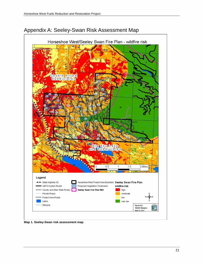
Existing Condition A risk assessment identifying priority levels for treatment in the wildland urban interface of the Seeley-Swan Fire Plan region was developed, identifying high priorities for treatment (Seeley Lake Rural Fire District et al. 2008, page 30, 32). High priorities include Highway 83, the primary public road for ingress and egress to the Seeley-Swan area, which runs parallel to the Horseshoe West Project Area to the west, private lands in sections 5, 7, 8, 12 and 14 adjacent to the Double Arrow Subdivision, and sections 22, 28, 29 and 30 near the Big Sky Lake Subdivision that contain residential development including both yearlong and seasonal cabins, and two powerline corridors that traverse the center of the project area and supply power to private residences south of the project area. The proposed project area focuses on these priority areas for treatment (see appendix A maps).
Fire History and Occurrence Fire has been the major influence on vegetation patterns, composition, structure, function, age and development of both individual stands and the larger landscape (Habeck and Mutch 1973; Arno 1976; Arno 1980; Fischer and Bradley 1987). The mixture of forest types found in northwestern Montana developed under a variety of fire regimes, varying with moisture, temperature, and vegetation composition. While insects and disease were and continue to be important disturbance agents as well, their activities often contribute to the occurrence and severity of fire as the end result. Consequently, the ultimate driving force of large-scale disturbance in the area was predominately fire (Seeley-Swan Fire Plan 2008, page 16).
Information on fire history since the 1870s for the project area was obtained from the Lolo National Forest GIS database. These records indicate that an extensive history of large severe wildfires have occurred in the area. The approximate boundaries and years of these historical fires are based on field surveys and local knowledge. The largest recorded fires occurred in 1910 and 1917. The fire in 1910 consumed approximately 19,766 acres and most of the proposed project area (see map in appendix B).
Large fire growth in the Seeley Valley is typically from the southwest, following the prevailing winds. Therefore, fires which start in the Mission Mountains west of the

Horseshoe West Fuels Reduction and Restoration Project
7
project area have the potential to move into, and across the valley where they may threaten homes and communities. Northwest winds have also led to large fire growth in the area. Fuel continuity across the landscape, and fuel quantity and arrangement, can play a significant role in large fire growth along with wind and moisture (i.e., drought). As evidenced by nearby fires in 2007 (Jocko Lakes Fire) stand-replacing fires can negatively affect forest resources and private properties.
In 2007, the Jocko Lakes Fire threatened the community of Seeley Lake, and resulted in the evacuation of large parts of the community for up to 2 weeks. Access to the community was restricted to local residents via the highway 83 corridor for a number of days, resulting in sizable losses to recreation-supported businesses. The fire history of the Seeley-Swan Valley coupled with severe weather patterns and current forest conditions suggest that future wildfire events are inevitable and could result in considerable loss of property and natural resources, as well as threaten the lives and safety of firefighters and residents alike (Seeley-Swan Fire Plan 2008, page 3).
Fire/Groups/Fire Regimes Fire groups discussed in Fisher and Bradley (1987) were used to examine fire’s ecological role on forest succession in correlation with fire regimes for the project area. These fire groups were further refined by Forest (USDA, EMB Guide) and used to assess landscape level fuels. Three fire groups dominate the areas proposed for treatment and much of the surrounding areas in the project analysis area. Fire group 6 is the most common with approximately 3,493 acres. Fire group 8 has approximately 494 acres and fire group 4 makes up approximately 133 acres. The remaining acres inside and outside the treatment units are comprised of a variety of fire groups including 0 and 7.
The three fire groups that dominate the treatment areas are summarized below.
Fire Group 4: Fire group 4 is defined as warm, dry Douglas-fir habitat types where ponderosa pine usually occurs as a major seral or climax associate to Douglas-fir, especially at lower elevations. In the absence of fire, Douglas-fir regenerates beneath the pine and eventually dominates the overstory. In fire group 4 the natural fire-free interval ranged from 5to 25 years; these stands typically had frequent low-severity wildfires on drier sites that thinned smaller trees in stands. This maintained open stands of old growth ponderosa pine, Douglas-fir, and/or larch. With increasing intervals between fires due to fire exclusion, understory trees have had a chance to grow and become ladder fuels that can carry surface fires up into the overstory canopy with lethal results.
Fire Group 6: Fire group 6 is defined as cool and moist Douglas-fir types. Fire group 6 habitat types normally occur at lower elevations on many aspects. These stands were characterized by mixed species (ponderosa pine, Douglas-fir, western larch, lodgepole pine, and grand fir). In fire group 6 the natural fire-free interval is 15 to 42 years. Fire exclusion and logging of dominant trees from many of these sites over the last 60 years has changed the vegetation composition and structure. Currently, these stands are dominated by dense, multistoried structures with a high composition of Douglas-fir. Wildfire in these changed vegetation communities has become a stand-replacement fire rather than a low-intensity burn.
Fire Group 8: Fire group 8 is defined as dry, lower subalpine habitat types. Douglas-fir and lodgepole pine are the dominant seral species in this habitat type. This is a collection
Fire/Fuels Report
8
of habitat types in the spruce and subalpine fir series that usually support mixed stands of Douglas-fir and lodgepole pine. Fire intervals range from 50 to 90 or 130 years (Fisher, 1987).
The natural or historic fire regime is a general classification of the role fire would play across the landscape in the absence of modern human intervention, but including the influence of aboriginal burning (Agee 1993). The natural or historic fire regimes are classified by number of years between fires (frequency) and the severity of the fire on the dominant overstory vegetation. Fire return intervals in the project area generally fall into natural fire regime groups III and IV and are described by Schmidt and others (2002). Fire regime groups III and IV associated with fire groups are defined as:
Fire Regime Group III: Fire frequency of 35 to 100+ years of mixed severity. A mixed severity fire could result in up to 75 percent replacement of the dominant overstory. In the project area, these sites would have been more moist than fire regime group I. This fire regime coincides with fire group 6 (USDA, EMB Guide).
Fire Regime Group IV: Fire frequency of 35 to 100+ years of high severity, stand-replacing fires. Greater than 75 percent of the dominant overstory vegetation could be replaced. These sites would have been more moist than fire regime group III and consisted of mixed conifer species with a heavier component of shade-tolerant species like grand fir. This fire regime coincides with fire groups 7, 8, and 9 (USDA, EMB Guide).
Fuel Conditions and Fire Hazard Fuel conditions vary widely throughout the project area. Vegetation conditions are characterized by the relationship of vegetation response units, fire groups, and habitat type groups vegetation and are further discussed in the Vegetation Report (Cutter 2011).
In general many of the stands proposed for treatment have developed fuel ladders as well as increased concentrations of surface fuels. Fuel loading and arrangement within the treatment areas varies considerably. The average total surface fuel loading over the proposed treatment areas ranges from about 10 to 89 tons per acre with an overall average of about 37 tons per acre. Most of the tonnage is in the form of large logs greater than 3 inches in diameter and is generally associated with the lodgepole-dominated stands. Throughout the lodgepole stands there are concentrations of these large logs that would also hinder the ability of firefighters to construct fireline. Stands dominated by Douglas-fir and larch have less surface fuel loading, but have a higher degree of understory ladder fuels comprised of small trees and low hanging limbs. With concentrations of dead fuels, individual trees or groups of trees may torch, and fire may continue through the crowns aided by high winds. Ignition in many of these types of stands could produce high or extreme fire behavior, and potentially damage resource values and threaten private lands.
Treatments that decrease surface, ladder, and canopy fuels are needed to make the area more resistant to stand-replacing wildfires. Stands throughout the project area have accumulated surface and ladder fuels that would threaten overstory trees in the event of a wildfire. High levels of tree mortality are predicted in the event of a wildfire. Kean and others (2002) state that since the early 1930s, fire suppression programs in the United States and Canada successfully reduced wildland fires in many Rocky Mountain

Horseshoe West Fuels Reduction and Restoration Project
9
ecosystems. This lack of fires has created forest and range landscapes with atypical accumulations of fuels that pose a hazard to many ecosystem characteristics. The health of many Rocky Mountain ecosystems is now in decline because of fire exclusion; fire exclusion has actually made it more difficult to fight fires, and this poses greater risks to the people who fight fires and for those who live in and around Rocky Mountain forests and rangelands. They also indicate that the role of fire will continue to change in the Rocky Mountains as we continue to exclude fires from landscapes. It is not a question of if a landscape will burn, but rather, when and how severe.
Fireline intensity is widely used as a means to relate visible fire characteristics and interpret general suppression strategies. There are several ways of expressing fireline intensity. A visual indicator of fireline intensity is flame length (Rothermel 1983). These flame length classes and interpretations are familiar to fire managers and are widely accepted as an intuitive communications tool. Table 1 compares fireline intensity, flame length, and fire suppression difficulty interpretations.
Table 1. Fireline intensity interpretations Fireline Intensity
Flame Length Interpretations
Low < 4 feet Direct attack at the head and flanks with hand crews; handlines should stop spread of fire.
Moderate 4−8 feet
Fires are too intense for direct attack on the head by persons using handtools. Handline cannot be relied on to stop fire spread. Equipment such as dozers, engines, and retardant aircraft can be effective.
High 8−11 feet Fires may present serious control problems such as torching, crowning, and spotting. Control efforts at the fire head are likely ineffective. This fire would require indirect attack methods.
Very High > 11 feet Crowning, spotting, and major fire runs are probable; control efforts at the head are likely ineffective. This fire would require indirect attack methods.
Note: Table based on Rothermel (1983).
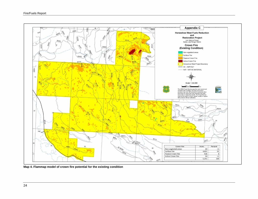
Fire modeling was used to evaluate the existing potential of flame length associated with fireline intensity and crown fire for the proposed project area under high fire danger (97th percentile) weather conditions. Results of these modeled outcomes are summarized in Table 2 and visually displayed in appendix C.
As shown in Table 2, modeling suggests that approximately 9 percent of the area has potential fire behavior characteristics that make direct suppression strategies ineffective or unsafe for firefighters, making it necessary to utilize mechanized equipment, and possibly aircraft, for suppression activities. Although the total acreage of project area exhibiting these conditions is relatively low, the proximity to homes and critical infrastructure is most disturbing. Conditions like these can lead to high acreage burned and significant adverse effects on resources (Scott and Reinhardt 2001). This would likely be much higher under extreme weather conditions such as drought.
Fire/Fuels Report
10
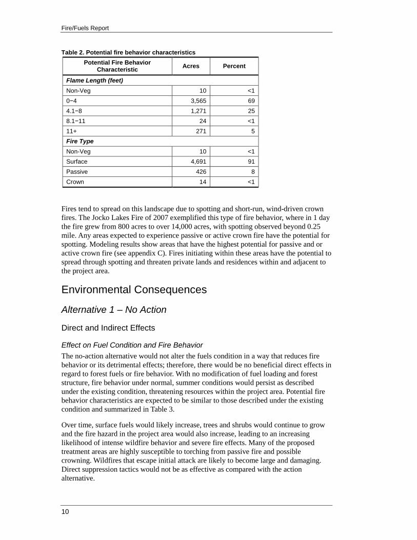
Table 2. Potential fire behavior characteristics Potential Fire Behavior
Characteristic Acres Percent
Flame Length (feet) Non-Veg 10 <1 0−4 3,565 69 4.1−8 1,271 25 8.1−11 24 <1 11+ 271 5 Fire Type Non-Veg 10 <1 Surface 4,691 91 Passive 426 8 Crown 14 <1
Fires tend to spread on this landscape due to spotting and short-run, wind-driven crown fires. The Jocko Lakes Fire of 2007 exemplified this type of fire behavior, where in 1 day the fire grew from 800 acres to over 14,000 acres, with spotting observed beyond 0.25 mile. Any areas expected to experience passive or active crown fire have the potential for spotting. Modeling results show areas that have the highest potential for passive and or active crown fire (see appendix C). Fires initiating within these areas have the potential to spread through spotting and threaten private lands and residences within and adjacent to the project area.
Environmental Consequences
Alternative 1 – No Action
Direct and Indirect Effects
Effect on Fuel Condition and Fire Behavior The no-action alternative would not alter the fuels condition in a way that reduces fire behavior or its detrimental effects; therefore, there would be no beneficial direct effects in regard to forest fuels or fire behavior. With no modification of fuel loading and forest structure, fire behavior under normal, summer conditions would persist as described under the existing condition, threatening resources within the project area. Potential fire behavior characteristics are expected to be similar to those described under the existing condition and summarized in Table 3.
Over time, surface fuels would likely increase, trees and shrubs would continue to grow and the fire hazard in the project area would also increase, leading to an increasing likelihood of intense wildfire behavior and severe fire effects. Many of the proposed treatment areas are highly susceptible to torching from passive fire and possible crowning. Wildfires that escape initial attack are likely to become large and damaging. Direct suppression tactics would not be as effective as compared with the action alternative.
Horseshoe West Fuels Reduction and Restoration Project
11
In the absence of any kind of human-caused or natural disturbance, indirect effects would occur from the natural progression of forest growth and change. The result would be increased surface, ladder, and crown fuels that affect flame length, contribute to the torching of trees, and make crown fire more likely (Peterson et al. 2005; Graham 2004). Fire risk in the project analysis area would likely increase and contribute to severe wildfires that could destroy important resources and habitat. Fire suppression will become more difficult and more costly as conditions worsen with time. This would increase the likelihood of a crowning wildfire of significant magnitude and intensity that could involve the wildland-urban interface and adjacent private lands, and impact the Highway 83 corridor used for access and egress by the public and firefighters. In areas where mountain pine beetle mortality is currently occurring, the addition of large accumulations of dead and down material will restrict fire suppression efforts and could increase fire size.
Effects on Climate Change Disturbance events such as wildfire could potentially lead to earlier atmospheric release of carbon stored in the project area. In the western United States, climate change and land management practices have led to increases in wildfire intensity and size (Wiedinmyer 2010). If no action is taken in the project area to address the purpose and need and the project objectives, there would be no direct greenhouse gas emissions or direct changes in climate or overall vegetation patterns. Carbon would remain sequestered in the forested portions of the project area. Not taking action to reduce tree stocking and improve forest health in the proposed treatment areas would contribute to a less resilient ecosystem that would be more susceptible to large fires. If a wildfire were to start in the project area, it is likely to be a moderate or even high-intensity fire. A high-intensity, stand-replacing wildfire would result in substantial greenhouse gas emissions, primarily through the release of carbon dioxide. Wiedinmyer and others (2010) found that carbon sequestration by forested ecosystems offers a potential climate change mitigation benefit. However, they also suggest that wildfire has the potential to reverse this benefit.
Compliance with Forest Plan and Other Relevant Laws, Regulations, Policies and Plans As a result of implementing the no-action alternative, critical portions of the project area would remain at high risk for high intensity fire and would be more vulnerable for stand-replacing wildfire under extreme conditions. In addition, the Forest Service might be viewed as not meeting commitments it has made to reduce fire behavior in the wildland-urban interface as a member of the Seeley-Swan Fire Plan.
Implementation of the no-action alternative would counteract the recent and past activities that have occurred north and south of the project area and along the Highway 83 corridor, offsetting lower wildfire severity effects. The no-action alternative would decrease fire protection capabilities on lands adjacent to the project area. It is also probable that a wildfire generated inside the project area would threaten private lands and residences adjacent to the project boundary.
Fire suppression activities would still occur within the project area. However, this alternative would not achieve the National Fire Plan goals, Forest Plan goals and standards and guidelines, or be responsive to the Seeley-Swan Fire Plan goals and objectives.
Fire/Fuels Report
12
Alternative 2 – Proposed Action
Direct and Indirect Effects
Effect on Fuel Conditions and Fire Behavior Proposed treatments as modified by the project design features and described in the Vegetation Report (Cutter 2011) and the environmental assessment are expected to reduce surface, ladder, and crown fuels and change the fuel model profile in all of the proposed treatment areas. This reduces predicted flame lengths and crown fire risk allowing firefighters greater success in protecting important forest and private resources, while at the same time increasing fire fighter and public safety. By treating these stands, they become more resilient to stand-replacing wildfire and allow greater protection within the wildland-urban interface zone. Treatments would help set the stage to introduce more low-intensity prescribed fire in the future and to maintain historic fire regimes.
Progress would be made towards the restoration of ecological processes that include the reintroduction of prescribed fire to help maintain historic fire regimes. Approximately 4.7 miles of fireline constructed by hand would be associated with this alternative. The ability of firefighters to safely and effectively suppress wildland fire would be greatly improved with these treatments.
The action alternative would promote forest health, distribute beneficial fire effects, and reduce the risk from wildfire to firefighters and the public. National Forest System lands and adjacent private lands would be positively affected due to a reduced likelihood for large-scale severe wildfires and maintaining historic fire regimes. The selection of this alternative would contribute to the purpose and need, the desired condition, LRMP direction, Seeley-Swan Fire Plan, and respond to the National Fire Plan goals of reducing hazardous fuels to modify current fire behavior.
Forest stands would be thinned to create a forest where periodic low-intensity surface fires can be safely reintroduced. Proposed thinning would help reduce overcrowded forest conditions and enhance tree survival from insects, disease, and drought. Trees to be removed would generally be smaller than trees to be retained.
The soils project design features are expected to increase coarse woody debris over a much longer time frame than the 10-year temporal scale selected for this analysis and include dead or damaged standing trees. Isolated dead standing trees tend to have minimal effects on fire behavior and their specific locations are nearly impossible to predict. Therefore an average or midpoint value of 12 to 15 tons per acre in woody material greater than 3 inches in diameter, and 2 tons per acre in woody material less than 3 inches was used to reflect how implementation of these features would affect fire behavior over the analyzed landscape and within the selected temporal scale.
The proposed treatments would reduce surface fuels and raise canopy base heights by reducing the ladder fuels, and reduce stand density by thinning, resulting in reduced fire behavior. Fire behavior was modeled based on surface fuels, stand composition, and structure to evaluate potential fireline intensity and crown fire for the entire project analysis area. The modeled results are summarized in

Horseshoe West Fuels Reduction and Restoration Project
13
Table 3 and can be viewed in appendix C. The proposed action would result in a 3 percent improvement in areas with flame lengths less than 4 feet and 3 percent increase in acres of surface fire type.
Table 3. Alternative comparison of potential fire behavior characteristics expected within the project area
Potential Fire Behavior Characteristic
No Action Proposed Action Difference
Acres % Acres % Acres %
Flame Length (feet) Non-Veg 10 <1 10 <1 0 0 0−4 3,565 69 3,704 72 139 +3 4.1−8 1,271 25 1,254 24 17 -<1 8.1−11 24 <1 18 <1 6 -<1 11+ 271 5 156 3 115 -2 Fire Type Non-Veg 10 <1 10 <1 0 0 Surface 4,691 91 4,836 94 145 +3 Passive 426 8 281 5 145 -3 Crown 14 <1 14 <1 0 0
As noted above, proposed treatments under this alternative result in relatively small percentage changes in the total project area, but these changes occur in strategic areas of importance. Post-treatment fire modeling suggests the proposed treatments would target approximately 64 percent of the high risk areas and approximately 70 percent of the moderate risk acres as rated by the Seeley-Swan Fire Plan. A review of the fuel modeling maps (appendix C) shows the remaining acres in each category have been effectively isolated from one another by these treatments. These areas were not treated due to environmental considerations such as slope, riparian or wetland sensitivity. and /or cover requirements for big game.
The level of previous harvesting activity while under private ownership was fairly effective at reducing potential fire behavior throughout much of the project area with the exception of these high and moderate risk areas. Treatment of the proposed Horseshoe West Project acres will be of strategic importance in future fire suppression efforts and will complement past treatments and those currently occurring or being proposed on adjacent state and private lands.
The Clear East Timber Sale in section 24 on land administered by the State of Montana is currently in the planning stage as part of the Clearview EA. This timber sale is planned just west of the project boundary. Harvesting activity is planned between 2013 and 2016 with an estimated 2 million board feet of merchantable material to be removed. Most of the harvesting activity is planned east of Highway 83 with a small amount occurring west of the highway. Fuel ladder reduction and activity fuel removal planned as part of this timber sale should also greatly reduce fire behavior in this parcel. While the State has identified general considerations of the proposal, it lacks enough specificity as a reasonably foreseeable action to provide a basis for analysis in the cumulative effects section of the Horseshoe West Project.
Fire/Fuels Report
14
If implemented, however, the State of Montana’s Clear East Timber Sale and associated actions may provide opportunities to cooperate in the use of prescribed fire between the State of Montana and the Forest Service in the future. If that potential collaboration occurs, existing roads and trails on State ownership could serve as control features. This could significantly reduce the amount of fireline construction needed from approximately 4.7 miles to approximately 2.8 miles. This opportunity would also reduce the amount of hand piling needed by approximately 102 acres, thereby reducing implementation costs.
Scientific findings indicate the most appropriate fuel treatment strategy is often thinning (removing ladder fuels and decreasing crown density) followed by prescribed fire, piling and burning fuels, and mechanical treatments. These treatments would provide maximum protection from severe fires in the future (Peterson 2005). Other research shows that areas treated before a fire begins can decrease severity (Strom and Fule 2007; Peterson et al. 2005; Omi and Martinson 2004; Agee and Skinner 2005; Graham 2004; Pollet and Omi 2002; Fule et al. 2001). However, in extreme weather conditions, such as drought and high winds, fuel treatments may do little to mitigate fire spread or severity (Pollet and Omi 2002).
Treatments on national forest land would reduce fire intensity and crown fire potential, but may not directly protect all homes. Studies indicate that wildfire mitigation focused on structures and their immediate surroundings is the most effective at reducing structure ignitions (Cohen 1999, 2000, 2002; Scott 2003).
While individual home-by-home treatments can also help reduce the risk of loss of individual homes, relying solely on such treatments would forego strategic opportunities for controlling fires within this wildland-urban interface area. Although homes in the path of a wildfire are perhaps the most immediately recognized value-at-risk, research has determined that treatments need to go beyond the home ignition zone for other resource values (Graham 2004).
A study conducted by Graham and others (2009) of wildfires during the summer of 2007 that burned over 500,000 acres within central Idaho observed that limited loss of structures and resource damage was largely due to the existence of the fuel treatments and how they interacted with suppression activities. In addition to modifying wildfire intensity, the burn severity to vegetation and soils within the areas where the fuels were treated was generally less compared to neighboring areas where the fuels were not treated. They noted that by modifying the fires’ behavior, the fuel treatments presented suppression opportunities that otherwise may not have been available. These opportunities ranged from providing locales to conduct burnouts to locating both hand- and machine-constructed firelines. In particular, the mechanical fuel treatments were very effective in creating conditions where surface fires dominated. Because of the lower intensity observed in these areas, they often provided safe zones for firefighters and crews who were then able to readily suppress the numerous spot fires that often occurred. Their observations suggest fuel treatments that create irregular forest structures and compositions, both within and among stands, tend to produce wildfire resilient forests.
Fire modeling for the Horseshoe West Project suggests the proposed treatments would be particularly effective at reducing fire behavior. Following implementation of the proposed action fire modeling suggests that 94 percent of the treated areas would exhibit surface fire and only 5 percent will exhibit passive fire, under the modeled conditions making fire

Horseshoe West Fuels Reduction and Restoration Project
15
suppression efforts more effective and safer for firefighters and other emergency responders.
For additional information and discussion regarding the science behind fuels treatments refer to appendix E.
Cumulative Effects Approximately 58 acres of harvesting in the Double Drew Timber Sale was recently completed in July 2010. This occurred on 160 acres administered by the State of Montana in section 12 adjacent to the Double Arrow Subdivision. This timber sale and associated activity removed an estimated 85,000 board feet of timber and will result in a significant reduction in fire behavior.
Most recently the Jocko Lakes Fire has increased the awareness of people in the community that more work needs to be done on both private and public lands. Many small private landowners have taken the initiative to reduce fuels on their own or through contract resources. Past fires have had an effect on the whole valley, both socially and ecologically. Based on the amount of work done to date and the areas fire history, it is safe to assume the work on private ownerships will continue in the future, and that fuels hazard reduction work on adjacent public land will also continue to be supported locally.
The action alternative would promote forest health, distribute beneficial fire effects, and reduce the risk from wildfire to firefighters and the public. National Forest System lands, adjacent wildland-urban interface, Plum Creek Timber lands, and adjacent private lands would be positively affected due to a reduced likelihood for large-scale severe wildfires and maintaining historic fire regimes. The selection of this alternative combined with past activities would modify fire behavior on the landscape by contributing to the overall reduction of surface, ladder, and crown fuels, therefore reducing fire intensity and severe crown fire. These combined treatments would complement the purpose and need goals for fire and fuels management. There would be beneficial cumulative effects associated with implementation of this alternative from these activities.
Effects on Climate Change Proposed treatments would temporarily alter carbon stores and carbon flux rates within treatment units. These local changes are similar to those that occur under natural forest disturbance events such as fire, wind, or insect epidemics. The resulting effects on atmospheric CO2 concentrations would be imperceptible in the short and the long term. The project would have no discernable impact on atmospheric concentrations of greenhouse gases, or global warming. Although treatments such as thinning, pile burning, and underburning under the proposed action would reduce standing carbon stocks and result in atmospheric emission of carbon, compared to the no-action alternative, these treatments would reduce the amount of carbon likely to be released to the atmosphere due to future fire disturbance (Finkral and Evans 2008). The proposed action is consistent with research recommendations (Krankina and Harmon 2006) for protecting carbon gains against the potential impacts of future climate change by reducing fuel loads through thinning.
The proposed action alternative would remove some carbon stored within treatment areas through fuel reduction activities, including prescribed burning. A recent study conducted by Wiedinmyer and others (2010) indicated carbon sequestration by forested ecosystems
Fire/Fuels Report
16
offers a potential climate change mitigation benefit. However, they state that wildfire has the potential to reverse this benefit. In the western United States, climate change and land management practices have led to increases in wildfire intensity and size. They also state that prescribed burning is a potential way to manage CO2 fluxes from forests in regions with high wildfire activity such as the western U.S. Managing forest fuels with prescribed fire requires repeated application at a frequency that is appropriate. Quantifying the carbon costs would require an assessment of the cumulative emissions coupled with quantification of sequestration by the remaining trees. In cases where high-severity fire can transition the forest from a sink to a source for an extended period of time, cumulative prescribed fire emissions are likely to be lower than wildfire emissions coupled with lost sink strength. They also suggest that in systems where tree regrowth is faster, repeated prescribed burning may have a higher carbon cost than a one-time wildfire event. Their findings indicate that prescribed burning emissions on a per-fire basis are considerably lower than emissions from wildfire. Furthermore, live tree mortality rates from prescribed burning are typically lower than from wildfire and the remaining live trees continue to sequester carbon.
A study conducted by Hurteau and North (2009) determined that forests are viewed as a potential sink for carbon that might otherwise contribute to climate change, and that it is unclear how to manage forests with frequent fire regimes to maximize carbon storage while reducing carbon emissions from prescribed burns or wildfire. They modeled the effects of eight different fuel treatments on tree-based carbon storage and release over a century, with and without wildfire. Model runs showed that, after a century of growth without wildfire, the control stored the most carbon. However, when wildfire was included in the model, the control had the largest total carbon emission and largest reduction in live-tree-based carbon stocks. In model runs including wildfire, the final amount of tree-based carbon sequestered was most affected by the stand structure initially produced by the different fuel treatments. Another study conducted by Hurteau and others (2008) found that in fire-prone forests, management that reduces the risk of catastrophic carbon release resulting from stand-replacing wildfire is considered to be a CO2 source, according to current accounting practices, even though such management may actually increase long-term carbon storage. Examining four of the largest wildfires in the U.S. in 2002 found that where forest land experienced catastrophic stand-replacing fire, prior thinning would have reduced CO2 release from live tree biomass by as much as 98 percent.
In wildfire-prone forests, tree-based carbon stocks were best protected by fuel treatments that produced a low-density stand structure dominated by large fire-resistant pines (Hurteau and North 2008).
Compliance with Forest Plan and Other Relevant Laws, Regulations, Policies and Plans Alternative 2 complies with Forest Plan goals, standards, and guidelines, and National Fire Plan goals, is consistent with the Lolo National Forest Fire Management Plan. and is responsive to the Seeley-Swan Fire Plan.

Horseshoe West Fuels Reduction and Restoration Project
17
References Agee, J.K. 1993. Fire ecology of Pacific Northwest forests. Island Press, Washington,
DC. 493 p.
Arno, S.F. 1976. The historical role of fire on the Bitterroot National Forest. Research Paper INT-187, USDA Forest Service, Intermountain Forest and Range Experiment Station, Ogden, UT. 29 p.
Arno, S.F.; Parsons, D.J.; Keane, R.E. 2000. Mixed-severity fire regimes in the northern Rocky Mountains: Consequences of fire exclusion and options for the future. In: Cole, D.N.; McCool, S.F.; Borrie, W.T.; O’Loughlin, J.; compilers. 2000. Wilderness science in a time of change conference, volume 5: Wilderness ecosystems, threats, and management; 1999 May 23–27; Missoula, MT. Proceedings RMRS-P-15-VOL-5, USDA Forest Service, Rocky Mountain Research Station, Ogden, UT. p. 225−232.
Cohen, J.D.; Saveland, J. 1997. Structure ignition assessment can help reduce fire damages in the WUI [http://www.firelab.org/].
Cohen, J. D. 2002. Wildland-urban fire: A different approach [http://www.firelab.org/].
Cohen, J.D. 1999. Reducing the wildland fire threat to homes: Where and how much? In: Gonzales-Caban, A.; Omi, P.N.; technical coordinators. Proceedings of the Symposium on Fire Economics, Planning, and Policy: Bottom Lines; 1999 April 5−9. San Diego, CA. General Technical Report PSW-GTR-173, USDA Forest Service, Pacific Southwest Research Station, Albany, CA. p. 189−195 [http://www.fs.fed.us/rm/pubs_other/rmrs_1999_cohen_j001.pdf].
Cohen, J.D. 2000. What is the wildland fire threat to homes? Presented as the Thompson Memorial Lecture, School of Forestry, Northern Arizona University, Flagstaff, AZ. [April 10, 2000. http://www.nps.gov/fire/download/pub_pub_wildlandfirethreat.pdf].
Cohen, J.D. 2003. Thoughts on the wildland-urban interface fire problem. Published in Wildfire Magazine and International Journal of Wildland Fire [http://www.nps.gov/fire/download/pub_pub_wildurbaninterface.pdf].
Cohen, J.D. 2003. An examination of the Summerhaven, Arizona, home destruction related to the local wildland fire behavior during the June 2003 Aspen Fire [http://www.governor.state.az.us/fhc/documents/SummerhavenWUIDestruction.pdf].
Cohen, J.D. 2003. Structure ignition assessment model (SIAM). USDA Forest Service General Technical Report PSW-GTR-158 (an abbreviated version of this paper was presented at the Biswell Symposium: Fire issues and solutions in urban interface and wildland ecosystems, February 15−17, 1994; Walnut Creek, CA. [http://www.fs.fed.us/psw/publications/documents/psw_gtr158/psw_gtr158_05_cohen.pdf].
Cutter, C. 2011. Horseshoe West Fuels Reduction and Restoration Project: Vegetation report. USDA Forest Service, Lolo National Forest, Seeley Lake Ranger District.

Fire/Fuels Report
18
Finney, M.A.; Seli, R.C.; McHugh, C.W.; [and others]. 2007. Simulation of long-term landscape-level fuel treatment effects on large wildfires. International Journal of Wildland Fire 16(6): 712−727.
Finney, M.A. 2006. An overview of FlamMap fire modeling capabilities. In: Andrews, P.L.; Butler, B.W.; compilers. Fuels management-how to measure success: Conference proceedings. March 28−30, 2006; RMRS-P-41, USDA Forest Service, Rocky Mountain Research Station, Portland, OR. p. 213−220.
Finney, M.A.; Cohen, J.D. 2003. Expectation and evaluation of fuel management objectives. In: P.N. Omi, P.N.; editor. Proceedings of Fire, Fuel Treatments, and Ecological Restoration, April 14−17, Ft. Collins CO. RMRS-P-29, USDA Forest Service, Rocky Mountain Research Station, Fort Collins, CO. p. 353−366.
Finney, M.A. 2007. A computational method for optimizing fuel treatment locations. International Journal of Wildland Fire 16(6): 702−711.
Fischer, W.C.; Bradley, A.F. 1987. Fire ecology of western Montana forest habitat types. General Technical Report INT-233, USDA Forest Service, Intermountain Research Station, Ogden UT.
Finkral, A.J.;Evans, A.M. 2008. The effects of a thinning treatment on carbon stocks in a northern Arizona ponderosa pine forest. Forest Ecology and Management 255: 2743-2750.
Fulé, P.Z.; McHugh, C.; Heinlein, T.A.; Covington, W.W. 2001. Potential fire behavior is reduced following forest restoration treatments. In: Proceedings of the RMRS-P-22. USDA Forest Service, Ogden, UT. p. 28–35.
Graham, R.T.; Jain, T.B.; Loseke, M. 2009. Fuel treatments, fire suppression, and their interaction with wildfire and its impacts the Warm Lake experience during the Cascade Complex of wildfires in central Idaho, 2007. General Technical Report RMRS-GTR-229, USDA Forest Service, Rocky Mountain Research Station, Fort Collins, CO. 36 p.
Graham, R.T.; McCaffrey, S.; Jain, T.B.; technical editors. 2004. Science basis for changing forest structure to modify wildfire behavior and severity. General Technical Report, RMRS-GTR-120, USDA Forest Service, Rocky Mountain Research Station, Fort Collins, CO. 43 p.
Graham, R.T.; Harvey, A.E.; Jain, T.B.; Tonn, J.R. 1999. The effects of thinning and similar stand treatments on fire behavior in Western Forests. General Technical Report PNW-GTR-463, USDA Forest Service, Pacific Northwest Research Station; USDI BLM. 28 p.
Habeck, J.R.; Mutch, R.W. 1973. Fire-dependent forests in the Northern Rocky Mountains. Quaternary Research 3: 408−424.
Hurteau, M.D.; North, M. 2009. Fuel treatment effects on tree-based forest carbon storage and emissions under modeled wildfire scenarios. Frontiers in Ecology and the Environment 2009(7) [doi:10.1890/080049(www.frontiersinecology.org)].
Hurteau, M.D.; Kock, G.W.; Hungate, B.A. 2008; Carbon protection and fire risk reduction: toward a full accounting of forest carbon offsets. Frontiers in Ecology and the Environment 2008(6) [doi:10.1890/070187; http://www.nc.bi.nlm.nih.gov/pmc/articles/PMC2651132/pdf/1750-0680-4-1.pdf].
Horseshoe West Fuels Reduction and Restoration Project
19
Krankina, O.N.; Harmon, M.E. 2006. Forest management strategies for carbon storage. In: Forests, carbon and climate change: A synthesis of science findings, a report by The Oregon Forest Resources Institute, Oregon State University College of Forestry, and Oregon Department of Forestry. p. 79−92.
Omi, P.N.; Martinson, E.J. 2002. Effect of fuels treatment on wildfire severity. Final report to Joint Fire Sciences Program Governing Board. Fort Collins, CO: Western Forest Fire Research Center, Colorado State University, Fort Collins. 40 p.
Omi, P.N., Martinson, E.J. 2004. Effectiveness of thinning and prescribed fire in reducing wildfire severity. In: Proceedings of the Sierra Nevada science symposium: Science for management and conservation. Murphy, D.D.; Stine, P.A.; editors. General Technical Report PSW-193, USDA Forest Service, Albany, CA. p. 87−92.
Pollet, J., Omi, P.N. 2002. Effect of thinning and prescribed burning on crown fire severity in ponderosa pine forests. International Journal of Wildland Fire 11: 1−10.
Peterson, D.W.; Hessburg, P.F.; Salter, B.; [and others]. 2007. Reintroducing fire in regenerated dry forests following stand-replacing wildfire. In: Powers, R.F.; technical editor. 2007. Restoring fire-adapted ecosystems: Proceedings of the 2005 national silviculture workshop. General Technical Report PSW-GTR-203, USDA Forest Service, Pacific Southwest Research Station, Albany, CA. 306 p. [http://www.fs.fed.us/psw/publications/documents/psw_gtr203/].
Peterson, D.L.; Johnson, M.C.; Agee, J.K.; [and others]. 2005. Forest structure and fire hazard in dry forests of the Western United States. General Technical Report PNW-GTR-628, USDA Forest Service, Pacific Southwest Research Station, Albany, CA. 30 p.
Reinhardt, E.; Crookston, N.L.; technical editors. 2003. The fire and fuels extension to the forest vegetation simulator. General Technical Report RMRS-GTR-116, USDA Forest Service, Rocky Mountain Research Station, Ogden, UT. 209 p.
Rothermel, R.C. 1983. How to predict the spread and intensity of forest and range fires. General Technical Report INT-143, USDA Forest Service, Intermountain Range and Experiment Station, Ogden, UT, 161 p.
Strom, B.; Fulé, P.Z. 2007. Pre-wildfire fuel treatments affect long-term ponderosa pine forest dynamics. International Journal of Wildland Fire 16(1): 128−138 [http://www.publish.csiro.au/index.cfm].
Seeley Lake Rural Fire District, Swan Valley Volunteer Fire Department, Montana Department of Natural Resources and Conservation, USDA Forest Service, Ecosystem Management Research Institute. 2008. Seeley-Swan fire plan: May 2008 update to the March 2004 plan [http://www.crcmt.org/fuelsmgmt/fuelstaskforce/2008fireplan.pdf].
Schmidt, K.M.; Menakis, J.P.; Hardy, C.C.; [and others]. 2002. Development of coarse-scale spatial data for wildland fire and fuel management. General Technical Report RMRS-GTR-87, USDA Forest Service, Rocky Mountain Research Station, Fort Collins, CO. 41 p. + CD [http://www.fs.fed.us/rm/pubs/rmrs_gtr87.pdf].

Fire/Fuels Report
20
Stratton, R.D. 2009. Guidebook on LANDFIRE fuels data acquisition, critique, modification, maintenance, and model calibration. General Technical Report RMRS-GTR-220, USDA Forest Service, Rocky Mountain Research Station, Fort Collins, CO. 54 p.
Scott, J.H. 2003. Canopy fuel treatment standards for the wildland-urban interface. USDA Forest Service Proceedings RMRS-P-29.
Scott, J.H.; Reinhardt, E.D. 2001. Assessing crown fire potential by linking models of surface and crown fire behavior. Research Paper RMRS-RP-29, USDA Forest Service, Rocky Mountain Research Station, Fort Collins, CO. 59 p.
Scott, J.H., Burgan, R.E.. 2005. Standard fire behavior fuel models: A comprehensive set for use with Rothermel's surface fire spread model. General Technical Report RMRS-GTR-153, USDA Forest Service, Rocky Mountain Research Station, Fort Collins, CO.
USDA Forest Service, Lolo National Forest, Ecosystem Management Burning Guide. Fire Regimes and Fire Groups. Chapter 3.
USDA Forest Service. 1986. Lolo National Forest Plan. Lolo National Forest, Northern Region, Missoula MT.
USDA Forest Service. 2010. Fire Effects Information System (FEIS) [available at: http://www.fs.fed.us/database/feis/].
USDA Forest Service. 2008. Lolo National Forest Fire Management Plan. Northern Region, Missoula MT.
USDA Forest Service. 2010. Lolo National Forest GIS Database. Lolo National Forest, Northern Region, Missoula MT.
USDI Bureau of Land Management and USDA Forest Service. 2000. Managing the impacts of wildland fires on communities and the environment: A report to the President (National Fire Plan) [http://www.forestsandrangelands.gov/].
USDI Bureau of Land Management and USDA Forest Service. 2002. A collaborative approach for reducing wildland fire risk to communities and the environment: 10-year comprehensive strategy [implementation plan available at: http://www.forestsandrangelands.gov/].
USDI Bureau of Land Management; USDA Forest Service; Department of Energy; [and others]. 1995. Federal Wildland Fire Policy [http://www.nifc.gov/fire_policy/index.htm and for 2001 updates http://www.nifc.gov/fire_policy/history/index.htm].
Wiedinmyer, C.; Hurteau, M.D. 2010. Prescribed fire as a means of reducing forest carbon emissions in the Western United States. Environmental Science and Technology 44(6): 1926−1932.
Veblen, T.T. 2003. Key issues in fire regime research for fuels management and ecological restoration. Proceedings RMS-P-22, USDA Forest Service, Rocky Mountain Research Station, Fort Collins, CO.
Horseshoe West Fuels Reduction and Restoration Project
21
Appendix A: Seeley-Swan Risk Assessment Map
Map 1. Seeley-Swan risk assessment map

Fire/Fuels Report
22
Appendix B: Horseshoe West Fire History Map
Map 2. Horseshoe West fire history map

Horseshoe West Fuels Reduction and Restoration Project
23
Appendix C: Flammap Modeling Results
Map 3. Flammap model of flame length potential for the existing condition
Fire/Fuels Report
24
Map 4. Flammap model of crown fire potential for the existing condition

Horseshoe West Fuels Reduction and Restoration Project
25
Map 5. Flammap model of potential flame length after treatment

Fire/Fuels Report
26
Map 6. Flammap model of potential crown fire after treatment
Horseshoe West Fuels Reduction and Restoration Project
27
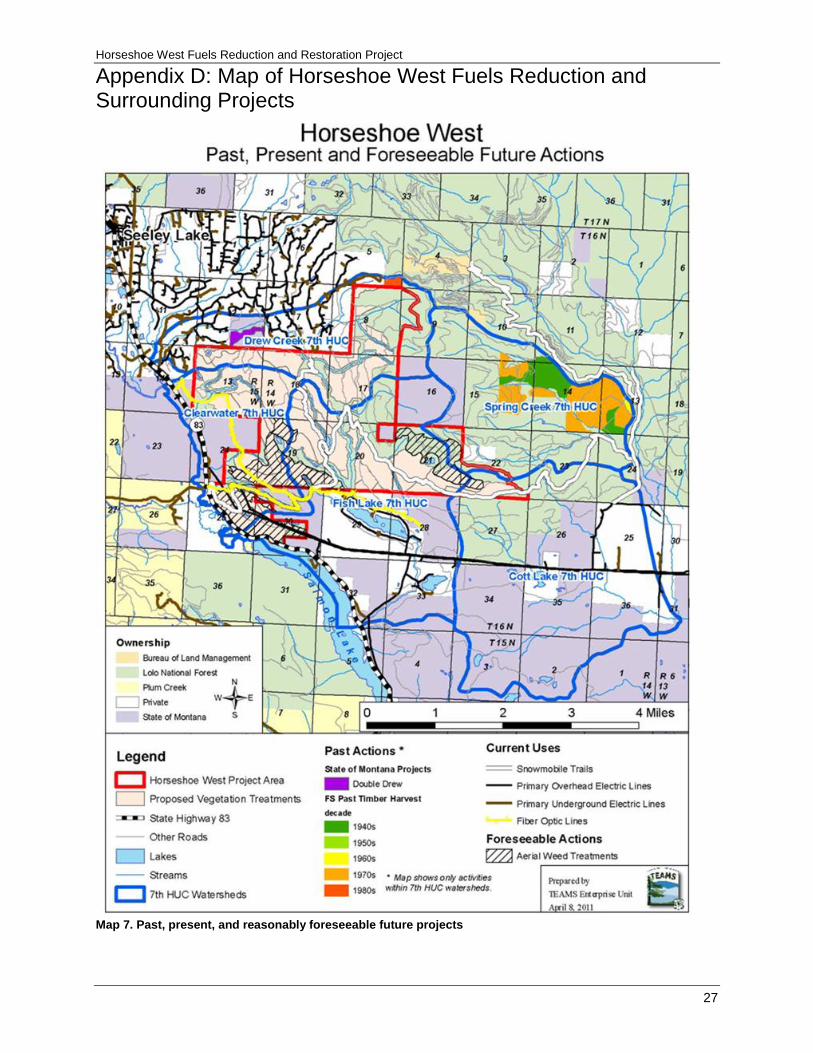
Appendix D: Map of Horseshoe West Fuels Reduction and Surrounding Projects
Map 7. Past, present, and reasonably foreseeable future projects
Fire/Fuels Report
28
Appendix E: Fuels Treatment Science–Selected Discussions from Literature There is a large body of literature that makes the case for treating fuels. There is even some controversy about the effectiveness of treatments of forest landscapes to reduce fire hazard. The following are examples.
Finney (2007) states:
Fuel treatment effects on wildland fire behavior have long been documented at the stand level (Biswell et al. 1973, Wagle and Eakle 1979, Helms 1979, Pollet and Omi 2002, Fernandes and Botelho 2003, Graham 2003). Prescribed burns and thinning operations change fuel structure and have together been successful in modifying fire behavior and consequent effects in the areas treated (Weaver 1943, Kallender et al. 1955, Cooper 1961, Martin et al. 1989, Graham et al. 1999, Schoennagle et al. 2004, Graham et al. 2004, Agee and Skinner 2005, Cram et al. 2006). The landscape level, however, is composed of many stands and mixtures of fuel conditions through which large fires burn, and there has been little work on strategies for treatment at this broad scale. Prescribed burning and general fuel management will be a necessary part of mitigating and even reversing effects of fire suppression (Arno et al. 2000). Evidence shows that even widespread treatments that change fire behavior at the stand-level can be circumvented by larger fires (Salazar et al. 1987, Dunn 1989, Finney et al. 2003).
Graham and others (2009) noted:
The intensity of the North Fork and Monumental Fires, in general, was lower on areas where the fuels had been treated compared to areas where they had not, regardless of whether the burning occurred during a burnout or one of the wildfires. In particular, the mechanical fuel treatments were very effective in creating conditions where surface fires dominated. Because of the lower intensity observed in these areas, they often provided safe zones for firefighters and crews were able to readily suppress the numerous spot fires that often occurred.
Peterson and others (2005) note:
Silvicultural thinning is implemented with the objective of reducing fuel loads and ultimately modifying fire behavior, but in some cases thinning activities can increase fine fuel loads and understory regeneration, thereby making fire behavior more severe (Agee 1996, Weatherspoon 1996). In addition, removal of larger, more fire resistant trees through thinning may result in high rates of damage to the residual smaller (and less fire resistant) trees in a subsequent fire (Weatherspoon and Skinner 1995). Thinning can in some cases alter stand structure and microclimate such that local fire weather conditions become worse. For example, removal of trees from the canopy and understory can increase surface wind movement (Albini and Baughman 1979), thereby facilitating surface fires and crown fires (Scott and Reinhardt 2001). Stand openings increase solar radiation in the crown and on the ground, and enhance wind circulation, which facilitates drying of live and dead fuels (Pollet and Omi 2002). This can effectively extend the duration of the fire season, because fuels will be dry enough to burn earlier in the year.
Graham and others (2004) state:
Qualitative observations, limited empirical data, and modeling provide the scientific basis for identifying how forest structure can be modified to reduce fire hazard and modify fire behavior.

Horseshoe West Fuels Reduction and Restoration Project
29
Additionally, research shows that when activities reduce surface fuels (low vegetation, woody fuel, shrub layer), those activities decrease the chances that surface fires will be able to ignite ladder fuels and canopy fuels (Weaver 1955, Cooper 1960, Biswell 1960, Biswell and others 1973, Martin and others 1989, Pollet and Omi 2002). The most effective strategy for reducing crown fire occurrence and severity is to (1) reduce surface fuels, (2) increase height to live crown, (3) reduce canopy bulk density, and (4) reduce continuity of the forest canopy (Van Wagner 1977, Agee 1996, Graham and others 1999, Scott and Reinhardt 2001, Cruz and others 2002).
Peterson and others (2005) note:
Observations from the Hayman Fire in Colorado and Cone Fire in California in 2002 suggest that past thinning treatments (Skinner 2003) and prescribed fire treatments (Graham 2002) effectively reduced fire behavior on relatively gentle slopes, with crown fires diminishing to surface fires in stands with lower stem densities and surface fuels. Stand structure and wildfire behavior are clearly linked (Biswell 1960, Cooper 1960, Dodge 1972, van Wagner 1977, Rothermel 1991, McLean 1993), so fuel reduction treatments are a logical solution to reducing extreme fire behavior. Extreme fire weather can override even intensive fuel treatments that remove large amounts of fuel. This is especially true under high winds and on steep slopes, conditions that facilitate rapid spread of crown fire and long-distance transport of burning embers (spotting).
Strom and Fule (2007) noted:
…even under the extreme conditions of drought and wind that characterized the Rodeo–Chediski, however, fuel reduction treatments that took place before the fire had a major effect in reducing fire severity and helping perpetuate ponderosa pine ecosystems. These treatments included prescribed burning (Finney et al. 2005) and thinning (Cram and Baker 2003; this study). These treatments comprised only a small portion of the burn area, however (Finney et al. 2005).
Scott and others (2003) state:
…canopy fuel treatments may reduce the potential for crown fire at the expense of slightly increased surface fire spread rate and intensity. However, critical levels of fire behavior (limit of manual or mechanical control) are less likely to be reached in stands treated to withstand crown fires, as all crown fires are uncontrollable. Though surface intensity may be increased after treatment, a fire that remains on the surface beneath a timber stand is generally controllable.
Pollet and Omi (2002) concluded:
…fuel treatments do mitigate fire severity. Treatments provide a window of opportunity for effective fire suppression and protecting high-value areas. Although topography and weather may play a more important role than fuels in governing fire behavior, topography and weather cannot be realistically manipulated to reduce fire severity.
Graham and other (2004) noted:
Forest ecosystems are inherently complex entities about which we have limited understanding. Detailed site-specific data on anything beyond basic forest structure and fuel properties are rare, limiting our analytical capability to prescribe management actions to achieve desired conditions for altering fuels and fire hazard. In the face of this complexity, it is important to focus on basic principles that assist decision making processes (Agee 2002b, Peterson and others 2003).
Fire/Fuels Report
30
These basic principals include reducing surface fuels to decrease surface fire behavior, reducing ladder fuels to increase height to crown base, and reducing canopy fuels to reduce the probability of crown fire. All of these treatments have been integrated into the design of the action alternative on the Horseshoe West Project.
Pollet and Omi (2002) state:
Fuel moistures may be affected by microclimate and probably vary between the untreated and treated stands. A more open stand allows more wind and solar radiation, resulting in a drier microclimate compared to a closed stand. A drier microclimate generally contributes to more severe fire behavior. However, our study does not support the assertion that more open stands experience higher fire severity. More open stands had significantly lower fire severities compared to the more densely stocked untreated stands in this study. The degree of openness in the studied treated stands may not have been sufficient to increase fire activity.
The Horseshoe West Project does not propose simply reducing tree density, and follows the direction of most of the scientific literature in treating surface, ladder, and canopy fuels through a variety of methods including prescribed fire. The project was designed to take advantage of the conditions in various areas of the project. Although prescribed fire by itself is effective in some situations, scientific literature does support the use of mechanical treatments in conjunction with prescribed fire.
A concern that there can be an over-reliance on summary fire statistics such as mean fire interval and rotation period and that fire regime research continues to inform management decisions in useful and important ways, but the quantity and quality of this research needs to be improved Veblen and others (2003). They also bring out the notion that ecological restoration needs to be attentive to proper place and appropriate time. We concur that more research is desirable and can be useful in helping to make land management decisions.
Concerns have been expressed suggesting that wildland fuel reduction for reducing home losses may be inefficient and ineffective and that treatment for effective fuel modification for reducing potential wildland-urban interface losses need only occur within a few tens of meters from a home, not hundreds of meters or more from a home (Cohen 1999).
Cohen’s paper says ignitibility of a house is due primarily to radiant heat from fuel burning nearby and firebrands igniting the building materials used in the structure. For example his research indicates that a flaming front at a distance of 40 meters (approximately 120 feet) or more from a structure does not deliver sufficient heat energy to ignite the exterior of a home. However, lofted firebrands are also a principle ignition factor. Highly ignitable homes can ignite during a wildland fire without a fire spreading near the structure. This occurs when firebrands are lofted downwind from fires. The firebrands subsequently collect on and ignite flammable home materials (such as roofs) and adjacent flammables (such as woodpiles, decking, and landscaped vegetation). Firebrands that result in ignitions can originate from wildland fires that are a distance of one kilometer (0.6 miles) or more (Cohen 2000).
The value of manipulating fuels around structures to provide a margin of safety to those structures is an accepted practice and is the responsibility of individual homeowners. Consistent with Cohen (2000), the Forest Service encourages residents within the wildland-urban interface to continue to do their part to reduce their risk to wildfire by creating defensible space around their homes and following Firewise practices (for more information, please see www.firewise.org). The management objective for the Horseshoe West Project is are also aimed at keeping wildfires out of the private communities so that the home ignition zone is not tested Fuel management objectives include managing fuels to alter fire behavior to reduce the source of firebrands, decrease the chance of fire threatening structures, and provide safer
Horseshoe West Fuels Reduction and Restoration Project
31
environments for fire suppression personnel. Fire researchers, Finney and Cohen (2003), suggest that wildland fuel management extending perhaps many kilometers away from urban locations is critical to reducing the likelihood that wildland fires will spread to urbanized areas and pose ignition threats. Wildland fuel treatments can change fire behavior, which would increase effectiveness of fire suppression, especially during initial attack by slowing fire growth and limiting spotting (Finney and Cohen 2003).
Research has also determined that treatments intended to reduce fuels around communities at risk, rather than individual structures, need to go beyond the home ignition zone (Graham, 2004). While individual home-by-home treatments can help reduce the risk of loss of individual homes, relying solely on such treatments would forego strategic opportunities for controlling fires within this wildland urban interface area. Furthermore protecting homes and private lands is not the only purpose of this treatment. This project proposal is also a restoration treatment, and a byproduct of this treatment is providing an additional measure of protection to private lands from wildfires.
Concern has been expressed that prescribed burning alone can be utilized in many cases where managers typically assume mechanical fuel reductions must be used. In some cases this may be true; however, based on field observations and data collected it has been determined that a combination of mechanical and prescribed burning is needed to more effectively achieve the purpose and need. Science-based literature also indicates the most appropriate fuel treatment strategy is often thinning (removing ladder fuels and decreasing crown density) followed by prescribed fire, piling and burning fuels, and mechanical treatments (Peterson 2005). Proposed treatments are expected to provide maximum protection from severe fires in the future as well as encourage forest health.
Thinning of overstocked small-diameter understory stands reduces the ladder fuels and the potential of passive or crown dominated fire. This would allow fire to remain in the surface fuels lowering the risk and allowing suppression resources to use more direct attack methods. According to Peterson et al. (2005) the most appropriate fuel treatment strategy is often thinning (removing ladder fuels and decreasing crown density) followed by prescribed fire, piling and burning fuels, and mechanical treatments. These treatments would increase protection from severe fires in the future.
Graham et al. (2004) noted that:
Forest ecosystems are inherently complex entities about which we have limited understanding. Detailed site-specific data on anything beyond basic forest structure and fuel properties are rare, limiting our analytical capability to prescribe management actions to achieve desired conditions for altering fuels and fire hazard. In the face of this complexity, it is important to focus on basic principles that assist decision making processes (Agee 2002b; Peterson and others 2003).
These basic principals include reducing surface fuels to decrease surface fire behavior, reducing ladder fuels to increase height to crown base, and reducing canopy fuels to reduce the probability of crown fire. All of these principles have been integrated into the design of the action alternatives for the Horseshoe West Project.