Horizontal and vertical movements of immature dusky sharks ...
12
Kroetz et al. Anim Biotelemetry (2021) 9:36 https://doi.org/10.1186/s40317-021-00258-8 TELEMETRY CASE REPORT Horizontal and vertical movements of immature dusky sharks Carcharhinus obscurus in relation to commercial longline fisheries in the western North Atlantic Ocean Andrea M. Kroetz 1,2,3* , Simon J. B. Gulak 2 and John K. Carlson 1 Abstract Background: Many species of sharks, including the dusky shark Carcharhinus obscurus, are often incidentally cap- tured in commercial pelagic and bottom longline fisheries. Incidental capture can lead to at-vessel or post-release mortality and can be detrimental to populations of threatened, endangered, or prohibited species. The estimated at- vessel mortality for dusky sharks can be high in longline fisheries and, to minimize mortality, time–area closures have been designated in the western North Atlantic Ocean to mitigate interactions with longline fisheries, yet incidental capture of dusky sharks is still common. We compared the vertical and horizontal movements of dusky sharks to the overall fishing effort and depth fished of commercial pelagic and bottom longline fisheries to determine when and where overlap is present that could lead to incidental capture. Results: Twenty-one (n = 21) dusky sharks were tagged with pop-up archival transmitting satellite tags and all were immature animals (123–200 cm FL) apart from two individuals (230 and 300 cm FL). Sharks were tagged off the coasts of North Carolina (71%) and Florida (29%). Twenty tags (95%) reported and provided tracks between 1 and 107 days (median 15 days) and 10 tags (50%) remained on sharks for > 4 days. Most individuals remained within the bottom longline closed area off the coast of North Carolina during their time at liberty. Dusky sharks primarily occupied the 20–40 m depth range 26% of the time, and overlapped with bottom and pelagic longline gears 41% and 59% of the time, respectively. Overlap was highest in the winter and spring for both commercial fisheries. Conclusions: The use of archival satellite telemetry in this study has provided valuable preliminary information on vertical and horizontal movements of immature dusky sharks in western North Atlantic Ocean. Dusky sharks may be more vulnerable to incidental capture in the pelagic longline fishery due to the high fishing effort, larger areas of horizontal overlap, and greater percentage of vertical overlap. This information will inform mitigation measures of commercial longline fisheries, which can work toward population rebuilding of the species. Keywords: Prohibited species, Satellite telemetry, Commercial fisheries, Elasmobranch © The Author(s) 2021. Open Access This article is licensed under a Creative Commons Attribution 4.0 International License, which permits use, sharing, adaptation, distribution and reproduction in any medium or format, as long as you give appropriate credit to the original author(s) and the source, provide a link to the Creative Commons licence, and indicate if changes were made. The images or other third party material in this article are included in the article’s Creative Commons licence, unless indicated otherwise in a credit line to the material. If material is not included in the article’s Creative Commons licence and your intended use is not permitted by statutory regulation or exceeds the permitted use, you will need to obtain permission directly from the copyright holder. To view a copy of this licence, visit http://creativecommons.org/licenses/by/4.0/. The Creative Commons Public Domain Dedication waiver (http://creativeco mmons.org/publicdomain/zero/1.0/) applies to the data made available in this article, unless otherwise stated in a credit line to the data. Background Many species of sharks are incidentally captured in commercial longline fisheries, which can often result in at-vessel or post-release mortality [1]. Life history char- acteristics of many sharks (e.g., late maturation and low fecundity) make them particularly susceptible to fishing pressure that can lead to population declines [2–4]. e Open Access Animal Biotelemetry *Correspondence: [email protected] 3 Present Address: Cooperative Institute for Marine and Atmospheric Studies, Rosenstiel School for Marine and Atmospheric Science, University of Miami, Miami, FL 33149, USA Full list of author information is available at the end of the article
Transcript of Horizontal and vertical movements of immature dusky sharks ...
Kroetz et al. Anim Biotelemetry (2021) 9:36 https://doi.org/10.1186/s40317-021-00258-8
TELEMETRY CASE REPORT
Horizontal and vertical movements of immature dusky sharks Carcharhinus obscurus in relation to commercial longline fisheries in the western North Atlantic OceanAndrea M. Kroetz1,2,3* , Simon J. B. Gulak2 and John K. Carlson1
Abstract
Background: Many species of sharks, including the dusky shark Carcharhinus obscurus, are often incidentally cap-tured in commercial pelagic and bottom longline fisheries. Incidental capture can lead to at-vessel or post-release mortality and can be detrimental to populations of threatened, endangered, or prohibited species. The estimated at-vessel mortality for dusky sharks can be high in longline fisheries and, to minimize mortality, time–area closures have been designated in the western North Atlantic Ocean to mitigate interactions with longline fisheries, yet incidental capture of dusky sharks is still common. We compared the vertical and horizontal movements of dusky sharks to the overall fishing effort and depth fished of commercial pelagic and bottom longline fisheries to determine when and where overlap is present that could lead to incidental capture.
Results: Twenty-one (n = 21) dusky sharks were tagged with pop-up archival transmitting satellite tags and all were immature animals (123–200 cm FL) apart from two individuals (230 and 300 cm FL). Sharks were tagged off the coasts of North Carolina (71%) and Florida (29%). Twenty tags (95%) reported and provided tracks between 1 and 107 days (median 15 days) and 10 tags (50%) remained on sharks for > 4 days. Most individuals remained within the bottom longline closed area off the coast of North Carolina during their time at liberty. Dusky sharks primarily occupied the 20–40 m depth range 26% of the time, and overlapped with bottom and pelagic longline gears 41% and 59% of the time, respectively. Overlap was highest in the winter and spring for both commercial fisheries.
Conclusions: The use of archival satellite telemetry in this study has provided valuable preliminary information on vertical and horizontal movements of immature dusky sharks in western North Atlantic Ocean. Dusky sharks may be more vulnerable to incidental capture in the pelagic longline fishery due to the high fishing effort, larger areas of horizontal overlap, and greater percentage of vertical overlap. This information will inform mitigation measures of commercial longline fisheries, which can work toward population rebuilding of the species.
Keywords: Prohibited species, Satellite telemetry, Commercial fisheries, Elasmobranch
© The Author(s) 2021. Open Access This article is licensed under a Creative Commons Attribution 4.0 International License, which permits use, sharing, adaptation, distribution and reproduction in any medium or format, as long as you give appropriate credit to the original author(s) and the source, provide a link to the Creative Commons licence, and indicate if changes were made. The images or other third party material in this article are included in the article’s Creative Commons licence, unless indicated otherwise in a credit line to the material. If material is not included in the article’s Creative Commons licence and your intended use is not permitted by statutory regulation or exceeds the permitted use, you will need to obtain permission directly from the copyright holder. To view a copy of this licence, visit http:// creat iveco mmons. org/ licen ses/ by/4. 0/. The Creative Commons Public Domain Dedication waiver (http:// creat iveco mmons. org/ publi cdoma in/ zero/1. 0/) applies to the data made available in this article, unless otherwise stated in a credit line to the data.
BackgroundMany species of sharks are incidentally captured in commercial longline fisheries, which can often result in at-vessel or post-release mortality [1]. Life history char-acteristics of many sharks (e.g., late maturation and low fecundity) make them particularly susceptible to fishing pressure that can lead to population declines [2–4]. The
Open Access
Animal Biotelemetry
*Correspondence: [email protected] Present Address: Cooperative Institute for Marine and Atmospheric Studies, Rosenstiel School for Marine and Atmospheric Science, University of Miami, Miami, FL 33149, USAFull list of author information is available at the end of the article
Page 2 of 12Kroetz et al. Anim Biotelemetry (2021) 9:36
dusky shark Carcharhinus obscurus is a highly migratory, coastal-pelagic species that inhabits temperate, subtropi-cal, and tropical waters worldwide [5]. In the western North Atlantic Ocean, this species can be found off Cape Cod, Massachusetts to the Florida Keys, and into the Gulf of Mexico (GOM) where movements between the U.S. Atlantic and GOM are common [6, 7]. The coast of North Carolina is known to be important for this species serving as both an aggregation location and a nursery as juveniles exhibit seasonal migrations to and from this area [6–9].
The dusky shark is a species of management and con-servation concern as the population in the U.S. western North Atlantic Ocean has declined since the 1980s and 1990s due to targeted fishing [8, 10]. Consequently, com-mercial harvest has been prohibited in U.S. waters since 2000 [10]. Despite their prohibited status, dusky sharks are still incidentally captured (i.e., as bycatch) in com-mercial pelagic and bottom longline fisheries along the eastern coast of the U.S. as Essential Fish Habitat for this species overlaps with the areas of operation for these fisheries [8, 11, 12]. The most recent stock assessment for this species indicated that dusky sharks continue to be overfished with overfishing still occurring, largely due to bycatch coupled with low productivity [13]. Inci-dental capture and the fate after release remains one of the greatest sources of uncertainty for this species and improving these data would benefit determining their status [14].
Commercial longline and net fisheries are prevalent throughout the GOM and along the eastern coast of the U.S., and these fisheries incidentally capture dusky sharks. Pelagic longline gear primarily targets swordfish, tunas, and, to a lesser degree, sharks, whereas bottom longline gear primarily targets large coastal sharks [8]. Although dusky sharks are incidentally caught in gillnet and trawl fisheries, pelagic and bottom longline fisheries are the greatest source of dusky shark bycatch [8, 14]. For example, dusky sharks are captured incidentally on shark bottom longline fishing gear comprising 1.9% and 3.0% of catch from historical and recent reports, respectively [12, 15]. Elasmobranchs have been reported to comprise 15% of total catch on pelagic longline fishing off the south-east coast of the U.S. and dusky sharks comprised 14.7% of that elasmobranch bycatch [16]. Dusky sharks caught as bycatch and discarded alive experience high rates of mortality. For example, at-vessel mortality is estimated to be 70–81% in bottom longline and 34–40% in pelagic longline fisheries [8, 14, 17, 18], whereas post-release mortality is variable ranging from 11 to 42% for bottom longline gear [19] and 0.6–17.3% on pelagic gear [20]. Alternative fishing measures, such as time–area closures,
gear restriction areas, and reduced soak time, may be effective management tools to reduce discard mortality.
In the mid-Atlantic region of the U.S., mitigation efforts have been put in place to reduce incidental cap-ture of dusky sharks in commercial longline fisheries. Observer data were used to establish a time–area clo-sure off the North Carolina coast for the bottom longline fishery when juvenile dusky sharks are most abundant (i.e., January 1–July 31, [21]). Similarly, a pelagic longline time–area closure was established off the South Caro-lina coast to reduce bycatch of non-targeted species and undersized swordfish (i.e., February 1–April 30, [21]). However, longline fisheries still pose a risk as they oper-ate outside of the time–area closures. Creating effective time–area closures requires knowledge of temporal and spatial patterns of habitat use for the species to be ben-eficial [22–25], and this information is currently limited for dusky sharks in the mid-Atlantic. Without knowledge on age-specific movements and habitat use and/or pref-erences of species to be protected, it is difficult to des-ignate and determine the efficacy of time–area closures [26–28]. However, tagging studies can elucidate times of the year when dusky sharks are most at risk (i.e., risk being the spatio-temporal overlap with longline gear) of encountering commercial fisheries. Given that the num-ber of discards occurring in commercial fisheries is the largest source of mortality, the objective of this study was to use satellite tagging technology to monitor habitat use, vertical, and horizontal movements of dusky sharks in the western North Atlantic Ocean. We compared shark vertical and horizontal movements to the depth of fished commercial longline gear and overall areas of fishing effort to determine when and where overlap is present that could lead to incidental capture and discards of this prohibited species.
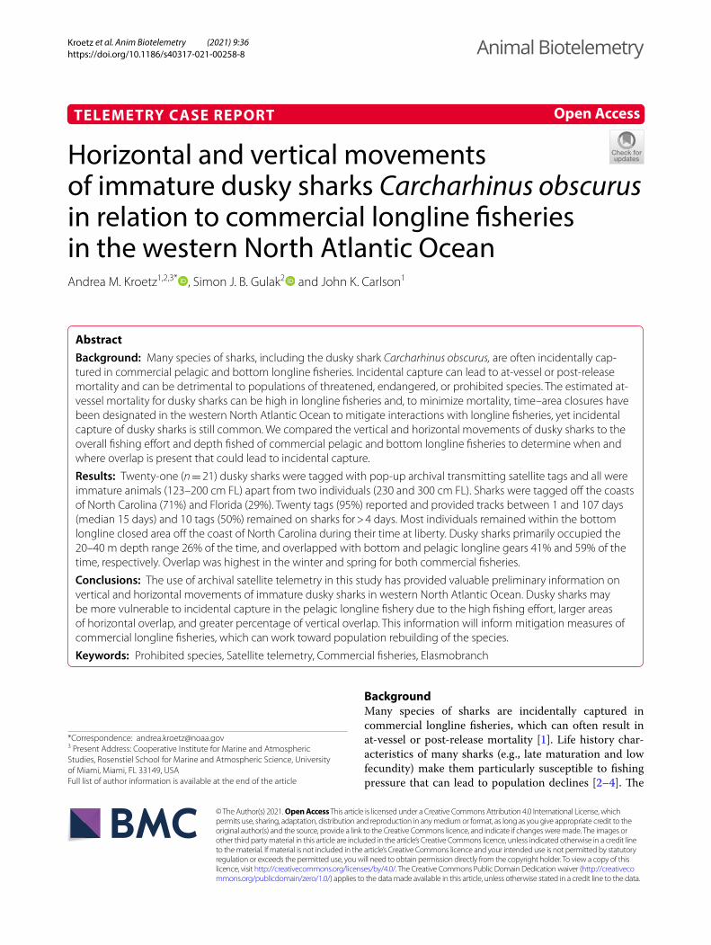
MethodsShark capture and taggingFrom 2009 to 2016, dusky sharks captured on com-mercial longline vessels monitored under the National Marine Fisheries Service’s (NMFS) Pelagic Observer Pro-gram [29] or Shark Bottom Longline Observer Program [30] were opportunistically tagged with pop-up archival transmitting tags (PAT; Wildlife Computers, Redmond, WA, U.S.) in the western North Atlantic Ocean (Fig. 1). Each PAT was equipped with a corrodible attachment link upon a 136 kg monofilament or a stainless steel leader (13 cm segment) that was wrapped in heat shrink and terminated in either a Domeier or Pfleger Institute of Environmental Research (PIER) nylon “umbrella” dart or a large titanium dart (59 × 13 mm) head [31]. In instances where sharks could be brought on deck, a har-ness consisting of stainless steel wire surrounded by chafe
Page 3 of 12Kroetz et al. Anim Biotelemetry (2021) 9:36
tubing was used to attach PATs. Upon capture, sharks were restrained alongside the vessel or brought on-board for tagging. Boated sharks were measured (fork length in cm, FL), otherwise FL was visually estimated, and sex was recorded. Reported size of maturity for this species (227 cm FL female; 226 cm FL male; [32]) was used to assign maturity for each shark. A small incision was made with a knife at the midline of the first dorsal fin approxi-mately 5 cm below the fin base and the PAT anchored in the dorsal musculature, seating the anchor at a depth of approximately 10 cm. The harness was attached through the base of the first dorsal fin via a small hole made in the fin. All tag models were programmed to release pre-maturely should the shark remain at a constant depth (± 1.5 m) for 72 h. Following release from a shark, data were transmitted to Argos satellites.
Satellite tagsThree generations of PAT tags were used in this study: Mk10-PAT, Mk10-PATF, and MiniPATs (Wildlife
Computers, Redmond, WA, USA). Tags were pro-grammed to archive pressure (depth [m]), temperature (°C), and geolocation (light intensity) at specific inter-vals. Due to battery constraints and transmission abili-ties, each tag model was programmed differently. The Mk10-PAT and Mk10-PATF tags were programmed to detach after 150 and 60 days of deployment, respec-tively. Temperature and depth were archived every 60 s of deployment and the tags transmitted 4-h summa-ries of temperature and depth in 14 pre-programmed bins (e.g., temperature ≤ 8, 8.05–10, 10.05–12, 12.05–14, 14.05–16, 16.05–18, 18.05–20, 20.05–24, 24.05–26, 26.05–28, 28.05–30, 30.05–32, 32.05–34, > 34 °C; depth ≤ surface, surface–20, 20.5–40, 40.5–60, 60.5–80, 80.5–100, 100.5–140, 140.5–180, 180.5–220, 220.5–260, 260.5–300, 300.5–340, 240.5–380, > 380 m) for these tag models. MiniPATs were programmed to release after 150 days of deployment and archived temperature and depth data every 75 s and transmitted 4-h summaries of temperature and depth in 12 pre-programmed bins
Fig. 1 Tagging locations of dusky sharks Carcharhinus obscurus (red triangles, n = 21) in the western North Atlantic Ocean from 2009 to 2016. Crosshatch gridmarks represent the Mid-Atlantic time–area closure for the bottom longline (BLL) fishery in effect from January 1 to July 31 yearly and simple hash gridmarks represent the time–area closures for the pelagic longline (PLL) fishery in effect from February 1 to April 30 (Charleston Bump) while the East Florida Coast is closed year-round
Page 4 of 12Kroetz et al. Anim Biotelemetry (2021) 9:36
(e.g., temperature ≤ 8, 8.05–10, 10.05–12, 12.05–14, 14.05–16, 16.05–18, 18.05–20, 20.05–24, 24.05–26, 26.05–28, 28.05–30, > 30 °C; depth ≤ surface, surface–20, 20.5–40, 40.5–60, 60.5–80, 80.5–100, 100.5–140, 140.5–180, 180.5–220, 220.5–260, 260.5–300, > 300 m).
Horizontal and vertical movementsAmbient light data recorded by the tags were used to produce daily location estimates while the shark was at liberty. Daily position was estimated using WC-GPE Suite provided by the tag manufacturer (GPE2, Wildlife Computers, Redmond, WA, USA). To refine estimates of geolocation, raw estimates of longitude and latitude were processed using an unscented Kalman filter with sea surface temperature correction in the statistical envi-ronment R [33] with the “ukfsst” package [34]. The most probable track was further bathymetrically corrected using the package “analyzepsat” package in R [35], which uses bathymetry to adjust position estimates within the estimated covariance (confidence) intervals and remove locations that are shallower than the daily maximum depth of the tag. Sea surface temperature (weekly mean at 1 degree resolution; NOAA Optimum Interpolation Sea Surface Temperature v2) and bathymetry (0.5 min resolution; SRTM30_PLUS Estimated Topography, 30 s, Global, v11) data used for geolocation filtering were obtained from NOAA Earth System Research Laboratory and NOAA Coastwatch [36]. Tags that release prema-turely may drift before overhead satellites detect them; similarly, tags will not release from deceased sharks until the constant depth mechanism is triggered after three days. Therefore, the last day of track was considered the day the tag reached the surface for premature releases or the shark settled on the seafloor for mortalities. This was confirmed using the tag status at release, depth his-tograms, and profiles of depth and temperature. Straight line distance between tag deployment and pop-up was calculated using Vincenty inverse formula for ellipsoids in R [37]. The most probable satellite tracks for individual sharks were mapped using QGIS software (version 3.2, [38]).
Vertical movements were analyzed using the combined 4-h summary histograms. Dusky sharks spent minimal time in the last three histogram bins for temperature and depth; therefore, temperature and depth data from the Mk10-PAT and MiniPAT tags were combined for analy-sis. Summaries for all tag models included time-at-depth and time-at-temperature histograms and a temperature–depth profile.
To assign time-of-day period to depth and tempera-ture data, the daily geographic position of the tagged sharks was used to estimate the times of dawn, sunrise, sunset, and dusk using the “maptools” package in R [33,
39]. On days where position estimates were not available, the positions were interpolated using a smooth spline with the “zoo” package in R [40]. Depth and tempera-ture data were assigned to a time-of-day period (i.e., day, night, and twilight) according to times of local dusk and dawn derived from longitude and latitude estimates from the most probable tracks [41]. Two histograms a day contained either dusk or dawn and thus were not com-pletely day or night period histograms and were defined as a transition period (twilight). To examine differ-ences in temperature and depth use, analysis of variance (ANOVA) was performed using the binned proportion of time spent at a temperature or depth as the depend-ent variable and time of day (i.e., day, night, and twilight) and temperature or depth as independent variables. The dependent data were transformed taking the arcsine of the square root [42] to normalize the data. Violations of assumptions of normality were tested post hoc using nor-mal probability and quantile–quantile plots of residuals.
Overlap with longline fisheriesDusky shark vulnerability to longline fisheries was ana-lyzed by overlaying kernel density estimates (KDEs) of daily dusky shark movements from PAT tags with KDE of commercial pelagic and bottom longline fishing effort obtained from NMFS observer programs for the years of our study (2009–2016). Although observer coverage for the pelagic and bottom longline fisheries is less than 100%, these data are reported in finer scale than log-book or available vessel monitoring system data. Kernel density was calculated in raw raster form using quartic shaped kernels using the Heatmap tool in QGIS. All ras-ters were re-projected to the World Mercator coordinate reference system (EPSG: 54004). The dusky shark daily locations were standardized to one position per day (the first successful location was arbitrarily selected), com-bined and split up by season (winter: December–Feb-ruary, spring: March–May, summer: June–August, fall: September–November). Sharks that were tracked for four days or less (n = 10) were removed to reduce the tag-ging location bias. There is a significant amount of uncer-tainty around light level location estimates, so the kernel density dynamic search radius for each point was set to 50 km. Fishing effort data (latitude and longitude where the longline set was made) were filtered to the extent of the dusky sharks’ horizontal movements (a box 22 to 41° North latitude and 82 to 71° West longitude) and split up by seasons and fishery. The KDEs were calculated using a radius of 50 km for pelagic longline sets and 10 km for bottom longline sets (average mainline length was 48.3 km for pelagic longlines [39] and 8.2 km for bot-tom longlines) and weighted by the fishing effort of the pelagic and bottom longline fleets. The probability of
Page 5 of 12Kroetz et al. Anim Biotelemetry (2021) 9:36
dusky shark interactions with longline fleets was calcu-lated by multiplying the KDE of dusky shark movements by the KDEs of the pelagic and bottom longline fisher-ies. Output rasters were scaled as percentage of overlap of the whole year to allow for seasonal comparison. The resulting KDE raster provides a visualization of the over-lap between dusky sharks and longline fleet effort. To compare the depth at which pelagic and bottom longline gear fished to dusky shark vertical habitat use, mean hook hours were arranged by fleet and fishing hook set depth in bins that matched the dusky shark histograms. The proportion of hook hours by depth was binned to match the dusky shark time-at-depth histogram, then plotted by fishing fleet alongside to quantitatively deter-mine overlap.
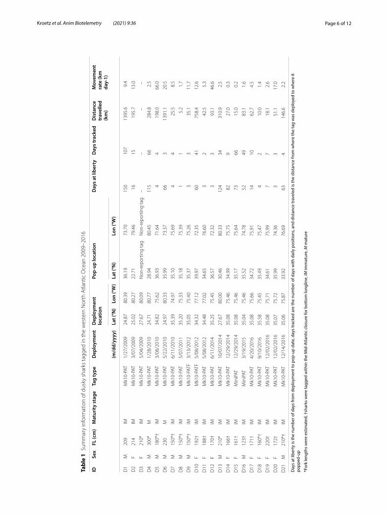
ResultsTwenty-one (n = 21) dusky sharks were fitted with archi-val satellite tags from 2009 to 2016 (Table 1). The major-ity of dusky sharks (n = 15, 71%) were tagged off North Carolina and 29% (n = 6) were tagged off the east coast of Florida (Fig. 1). Female dusky sharks (n = 11) ranged from 160 to 220 cm FL (median 184 cm) and were all imma-ture (< 227 cm FL); male sharks (n = 10) ranged from 123 to 300 cm FL (median 187 cm), and of these eight were immature (< 226 cm FL) and two were mature (Table 1). Twenty (n = 20) tags reported to the satellites, but only two tags reported to satellites on their scheduled pop-up date. Dusky sharks were tracked for up to 107 days with a mean (± SE) and median retention time of 42 ± 11 days and 15 days, respectively. Of the 20 reporting tags, 10 (50%) remained on sharks longer than four days and thus were used to identify horizontal movements and poten-tial overlap with longline fisheries.
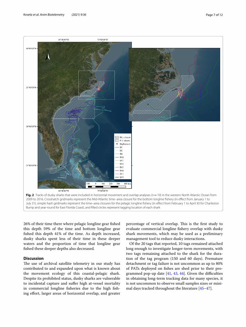
Horizontal movementsAll sharks remained in the western North Atlantic Ocean (Fig. 2). Two sharks tagged off south Florida traveled north to waters within the Mid-Atlantic closure for bot-tom longline and the sharks tagged near the Mid-Atlantic closure largely remained in that area. Of the two tags that popped-up on their scheduled date, shark D1 (209 cm FL, immature male, 107 days tracked) traveled 9.4 km day−1 between its tagging location in south Florida and its final location near the Mid-Atlantic closed area for bot-tom longline with most of its time at liberty spent off the North Carolina coast (Fig. 2). Shark D10 (192 cm FL, female, 41 days tracked) was tagged within the Mid-Atlantic closed area and remained in the general area before traveling north at approximately 12.6 km day−1 where the tag popped-up off the continental shelf (Fig. 2). Both animals made northward migrations during the
same months (May–July) where the tags popped-up in the western North Atlantic Ocean.
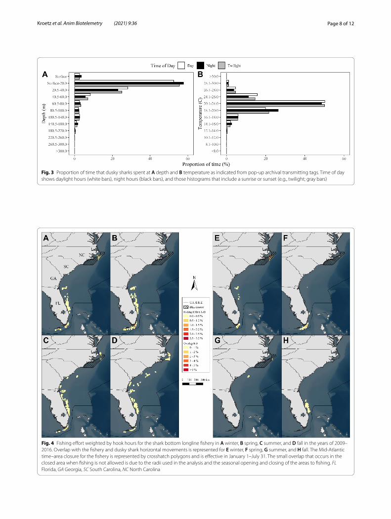
Vertical movementDusky sharks were observed in surface waters down to depths > 300 m (Fig. 3a) with a maximum depth of 440 m. The sharks primarily occupied depths from surface to 20.0 m (57.8% of time) followed by depths of 20.5–40.0 m (25.6% of time) (Fig. 3a). Occupied water temperatures ranged from 7.6 to 30.2 °C (Fig. 3b). Dusky sharks pri-marily inhabited water temperatures between 20.1 and 24.0 °C (49.8% of time), 18.1 and 20.0 °C (22.2% of time), and 24.1 and 26.0 °C (14% of time) (Fig. 3b). Depth and temperature bins that the sharks occupied were not affected by time of day (ANOVA; p > 0.9).
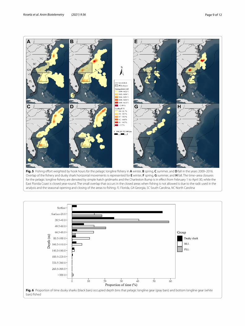
Overlap with longline fisheriesShark bottom longline fishing effort within the selected geographic range from 2009 to 2016 indicated that fish-ing effort (hook hours) was scattered along the east coast of Florida and up the Atlantic coastline from the Florida Keys to South Carolina across all seasons (Fig. 4a–d). Notably higher fishing effort was concentrated off the Florida Keys in the winter and spring (Fig. 4a, b) and off the coast of North Carolina near the Mid-Atlantic closure for this fishery in the summer and fall (Fig. 4c, d). Over-lap with dusky sharks was high within the Mid-Atlantic closed area in the winter (due to fishing sets made before the closure starts in December; Fig. 4e) and off the Flor-ida Keys in the winter and spring (Fig. 4e, f ). Overlap was notably lower during summer and fall (Fig. 4g, h).
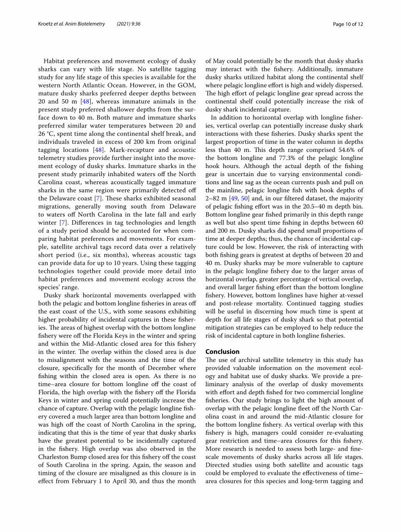
Pelagic longline fishing effort within the selected geo-graphic range from 2009 to 2016 weighted by hook hours indicated that the majority of effort was present in the western Atlantic from Florida to Long Island, New York (Fig. 5a–d). Notably higher fishing effort was concen-trated off the North Carolina coast and off the east coast of Florida in all months (Fig. 5a–d). Dusky shark overlap with this fishery was highest in the winter and spring off the coast of North Carolina (Fig. 5e, f ), and off the South Carolina coast in the Charleston Bump closure (Fig. 5f; in effect for two months in the spring season). Overlap was notably lower during summer (Fig. 5g) and no overlap was present in the fall (Fig. 5h).
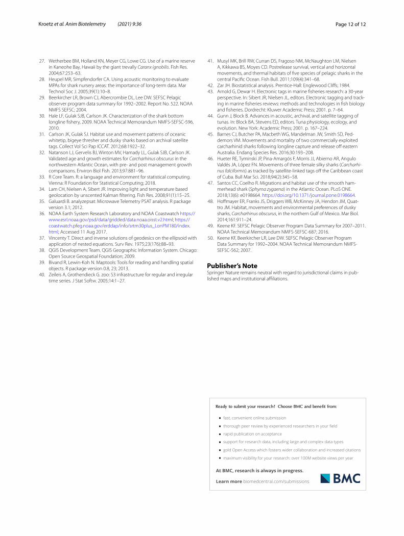
The highest proportion of depth bins fished by bot-tom and pelagic longline gear was similar to the high-est proportion of depth bins occupied by dusky sharks (Fig. 6). Dusky sharks spent 58% of their time within the depth range of surface–20 m, which is where bottom and pelagic longline fisheries exhibited the second and third highest proportion of time for hooks fished, respectively (Fig. 6). At the 20–40 m depth range, dusky sharks spent
Page 6 of 12Kroetz et al. Anim Biotelemetry (2021) 9:36
Tabl
e 1
Sum
mar
y in
form
atio
n of
dus
ky s
hark
s ta
gged
in th
e w
este
rn N
orth
Atla
ntic
Oce
an 2
009–
2016
Day
s at
libe
rty
is th
e nu
mbe
r of d
ays
from
dep
loym
ent t
o po
p-up
dat
e, d
ays
trac
ked
are
the
num
ber o
f day
s w
ith d
aily
pos
ition
s, an
d di
stan
ce tr
avel
ed is
the
dist
ance
from
whe
re th
e ta
g w
as d
eplo
yed
to w
here
it
popp
ed-u
p
*For
k le
ngth
s w
ere
estim
ated
, †sh
arks
wer
e ta
gged
with
in th
e M
id-A
tlant
ic c
losu
re fo
r bot
tom
long
line,
IM im
mat
ure,
M m
atur
e
IDSe
xFL
(cm
)M
atur
ity
stag
eTa
g ty
peD
eplo
ymen
tD
eplo
ymen
t lo
catio
nPo
p-up
loca
tion
Day
s at
libe
rty
Day
s tr
acke
dD
ista
nce
trav
elle
d (k
m)
Mov
emen
t ra
te (k
m
day-
1)(m
/dd/
yyyy
)La
t (°N
)Lo
n (°
W)
Lat (
°N)
Lon
(°W
)
D1
M20
9IM
Mk1
0-PA
T1/
27/2
009
24.8
780
.39
36.1
973
.70
150
107
1395
.69.
4
D2
F21
4IM
Mk1
0-PA
T3/
07/2
009
25.0
280
.27
22.7
179
.46
1615
195.
713
.0
D3
F21
0*IM
Mk1
0-PA
T5/
04/2
009
27.6
780
.09
Non
-rep
ortin
g ta
gN
on-r
epor
ting
tag
––
––
D4
M30
0*M
Mk1
0-PA
T1/
28/2
010
24.7
180
.77
28.9
480
.45
115
6628
4.8
2.5
D5
M18
0*†
IMM
k10-
PAT
3/08
/201
034
.82
75.6
236
.93
71.6
44
419
8.0
66.0
D6
M23
0M
Mk1
0-PA
T5/
22/2
010
24.9
780
.33
35.9
973
.37
663
1391
.120
.5
D7
M15
0*†
IMM
k10-
PAT
6/11
/201
035
.39
74.9
735
.10
75.6
94
425
.58.
5
D8
M15
0*†
IMM
k10-
PAT
5/07
/201
135
.20
75.3
335
.18
75.3
91
15.
21.
7
D9
M15
0*†
IMM
k10-
PATF
3/13
/201
235
.05
75.4
035
.37
75.2
63
335
.111
.7
D10
F19
2†IM
Mk1
0-PA
TF5/
08/2
012
34.3
277
.12
39.9
772
.35
6041
758.
412
.6
D11
F18
8†IM
Mk1
0-PA
T5/
08/2
012
34.4
877
.02
34.6
576
.60
32
42.5
5.3
D12
F17
0†IM
Mk1
0-PA
T6/
11/2
014
35.2
575
.45
36.5
772
.32
33
93.1
46.6
D13
M21
0*IM
Mk1
0-PA
T10
/07/
2014
27.6
780
.00
30.4
680
.33
124
3431
0.9
2.5
D14
F16
6†IM
Mk1
0-PA
T12
/29/
2014
35.0
875
.46
34.9
975
.75
829
27.0
0.3
D15
F16
1†IM
Min
iPAT
12/2
9/20
1435
.08
75.4
635
.17
75.6
473
6615
.00.
2
D16
M12
3†IM
Min
iPAT
3/19
/201
535
.04
75.4
635
.52
74.7
852
4983
.11.
6
D17
F17
1†IM
Mk1
0-PA
T4/
20/2
016
35.0
875
.66
34.7
275
.91
1410
62.7
4.5
D18
F16
0*†
IMM
k10-
PAT
9/10
/201
635
.58
75.4
535
.49
75.4
74
210
.01.
4
D19
F22
0†IM
Mk1
0-PA
T12
/02/
2016
35.0
875
.71
34.6
175
.99
77
18.1
2.6
D20
F17
2†IM
Mk1
0-PA
T12
/02/
2016
35.0
775
.72
35.9
974
.36
33
51.1
17.0
D21
M21
0*†
IMM
k10-
PAT
12/1
4/20
1635
.06
75.8
733
.92
76.6
963
414
6.6
2.2
Page 7 of 12Kroetz et al. Anim Biotelemetry (2021) 9:36
26% of their time there where pelagic longline gear fished this depth 59% of the time and bottom longline gear fished this depth 41% of the time. As depth increased, dusky sharks spent less of their time in these deeper waters and the proportion of time that longline gear fished these deeper depths also decreased.
DiscussionThe use of archival satellite telemetry in our study has contributed to and expanded upon what is known about the movement ecology of this coastal-pelagic shark. Despite its prohibited status, dusky sharks are vulnerable to incidental capture and suffer high at-vessel mortality in commercial longline fisheries due to the high fish-ing effort, larger areas of horizontal overlap, and greater
percentage of vertical overlap. This is the first study to evaluate commercial longline fishery overlap with dusky shark movements, which may be used as a preliminary management tool to reduce dusky interactions.
Of the 20 tags that reported, 10 tags remained attached long enough to investigate longer-term movements, with two tags remaining attached to the shark for the dura-tion of the tag program (150 and 60 days). Premature detachment or tag failure is not uncommon as up to 80% of PATs deployed on fishes are shed prior to their pro-grammed pop-up date [41, 43, 44]. Given the difficulties in obtaining long-term tracking data for many species, it is not uncommon to observe small samples sizes or mini-mal days tracked throughout the literature [45–47].
Fig. 2 Tracks of dusky sharks that were included in horizontal movement and overlap analyses (n = 10) in the western North Atlantic Ocean from 2009 to 2016. Crosshatch gridmarks represent the Mid-Atlantic time–area closure for the bottom longline fishery (in effect from January 1 to July 31), simple hash gridmarks represent the time–area closures for the pelagic longline fishery (in effect from February 1 to April 30 for Charleston Bump and year-round for East Florida Coast), and filled circles represent tagging location of each shark
Page 8 of 12Kroetz et al. Anim Biotelemetry (2021) 9:36
Fig. 3 Proportion of time that dusky sharks spent at A depth and B temperature as indicated from pop-up archival transmitting tags. Time of day shows daylight hours (white bars), night hours (black bars), and those histograms that include a sunrise or sunset (e.g., twilight; gray bars)
Fig. 4 Fishing effort weighted by hook hours for the shark bottom longline fishery in A winter, B spring, C summer, and D fall in the years of 2009–2016. Overlap with the fishery and dusky shark horizontal movements is represented for E winter, F spring, G summer, and H fall. The Mid-Atlantic time–area closure for the fishery is represented by crosshatch polygons and is effective in January 1–July 31. The small overlap that occurs in the closed area when fishing is not allowed is due to the radii used in the analysis and the seasonal opening and closing of the areas to fishing. FL Florida, GA Georgia, SC South Carolina, NC North Carolina
Page 9 of 12Kroetz et al. Anim Biotelemetry (2021) 9:36
Fig. 5 Fishing effort weighted by hook hours for the pelagic longline fishery in A winter, B spring, C summer, and D fall in the years 2009–2016. Overlap of the fishery and dusky shark horizontal movements is represented for E winter, F spring, G summer, and H fall. The time–area closures for the pelagic longline fishery are denoted by simple hatch gridmarks and the Charleston Bump is in effect from February 1 to April 30, while the East Florida Coast is closed year-round. The small overlap that occurs in the closed areas when fishing is not allowed is due to the radii used in the analysis and the seasonal opening and closing of the areas to fishing. FL Florida, GA Georgia, SC South Carolina, NC North Carolina
Fig. 6 Proportion of time dusky sharks (black bars) occupied depth bins that pelagic longline gear (gray bars) and bottom longline gear (white bars) fished
Page 10 of 12Kroetz et al. Anim Biotelemetry (2021) 9:36
Habitat preferences and movement ecology of dusky sharks can vary with life stage. No satellite tagging study for any life stage of this species is available for the western North Atlantic Ocean. However, in the GOM, mature dusky sharks preferred deeper depths between 20 and 50 m [48], whereas immature animals in the present study preferred shallower depths from the sur-face down to 40 m. Both mature and immature sharks preferred similar water temperatures between 20 and 26 °C, spent time along the continental shelf break, and individuals traveled in excess of 200 km from original tagging locations [48]. Mark-recapture and acoustic telemetry studies provide further insight into the move-ment ecology of dusky sharks. Immature sharks in the present study primarily inhabited waters off the North Carolina coast, whereas acoustically tagged immature sharks in the same region were primarily detected off the Delaware coast [7]. These sharks exhibited seasonal migrations, generally moving south from Delaware to waters off North Carolina in the late fall and early winter [7]. Differences in tag technologies and length of a study period should be accounted for when com-paring habitat preferences and movements. For exam-ple, satellite archival tags record data over a relatively short period (i.e., six months), whereas acoustic tags can provide data for up to 10 years. Using these tagging technologies together could provide more detail into habitat preferences and movement ecology across the species’ range.
Dusky shark horizontal movements overlapped with both the pelagic and bottom longline fisheries in areas off the east coast of the U.S., with some seasons exhibiting higher probability of incidental captures in these fisher-ies. The areas of highest overlap with the bottom longline fishery were off the Florida Keys in the winter and spring and within the Mid-Atlantic closed area for this fishery in the winter. The overlap within the closed area is due to misalignment with the seasons and the time of the closure, specifically for the month of December where fishing within the closed area is open. As there is no time–area closure for bottom longline off the coast of Florida, the high overlap with the fishery off the Florida Keys in winter and spring could potentially increase the chance of capture. Overlap with the pelagic longline fish-ery covered a much larger area than bottom longline and was high off the coast of North Carolina in the spring, indicating that this is the time of year that dusky sharks have the greatest potential to be incidentally captured in the fishery. High overlap was also observed in the Charleston Bump closed area for this fishery off the coast of South Carolina in the spring. Again, the season and timing of the closure are misaligned as this closure is in effect from February 1 to April 30, and thus the month
of May could potentially be the month that dusky sharks may interact with the fishery. Additionally, immature dusky sharks utilized habitat along the continental shelf where pelagic longline effort is high and widely dispersed. The high effort of pelagic longline gear spread across the continental shelf could potentially increase the risk of dusky shark incidental capture.
In addition to horizontal overlap with longline fisher-ies, vertical overlap can potentially increase dusky shark interactions with these fisheries. Dusky sharks spent the largest proportion of time in the water column in depths less than 40 m. This depth range comprised 54.6% of the bottom longline and 77.3% of the pelagic longline hook hours. Although the actual depth of the fishing gear is uncertain due to varying environmental condi-tions and line sag as the ocean currents push and pull on the mainline, pelagic longline fish with hook depths of 2–82 m [49, 50] and, in our filtered dataset, the majority of pelagic fishing effort was in the 20.5–40 m depth bin. Bottom longline gear fished primarily in this depth range as well but also spent time fishing in depths between 60 and 200 m. Dusky sharks did spend small proportions of time at deeper depths; thus, the chance of incidental cap-ture could be low. However, the risk of interacting with both fishing gears is greatest at depths of between 20 and 40 m. Dusky sharks may be more vulnerable to capture in the pelagic longline fishery due to the larger areas of horizontal overlap, greater percentage of vertical overlap, and overall larger fishing effort than the bottom longline fishery. However, bottom longlines have higher at-vessel and post-release mortality. Continued tagging studies will be useful in discerning how much time is spent at depth for all life stages of dusky shark so that potential mitigation strategies can be employed to help reduce the risk of incidental capture in both longline fisheries.
ConclusionThe use of archival satellite telemetry in this study has provided valuable information on the movement ecol-ogy and habitat use of dusky sharks. We provide a pre-liminary analysis of the overlap of dusky movements with effort and depth fished for two commercial longline fisheries. Our study brings to light the high amount of overlap with the pelagic longline fleet off the North Car-olina coast in and around the mid-Atlantic closure for the bottom longline fishery. As vertical overlap with this fishery is high, managers could consider re-evaluating gear restriction and time–area closures for this fishery. More research is needed to assess both large- and fine-scale movements of dusky sharks across all life stages. Directed studies using both satellite and acoustic tags could be employed to evaluate the effectiveness of time–area closures for this species and long-term tagging and

Page 11 of 12Kroetz et al. Anim Biotelemetry (2021) 9:36
post-release mortality studies will be valuable areas of research as fishery managers work toward population rebuilding of the species.
AcknowledgementsThe authors thank all fishery observers for collecting invaluable data while spending long hours at sea. They thank B. Doughtie, T. Kolkmeyer, L. Natanson, M. Lee, M. Cochran, and H. Moncrief-Cox for deploying tags on dusky sharks, A. Mathers for database queries, and K. Brewster-Geisz, D. Ortiz, and T. Curtis for providing constructive comments that improved this manuscript.
Authors’ contributionsAMK performed data analysis, interpretation of results, and wrote the major-ity of the manuscript; SJBG conducted fieldwork, analyzed the data, and contributed to the interpretation of results and writing of the manuscript; JKC secured funding for the project and contributed to data interpretation and writing of the manuscript. All authors read and approved the final manuscript.
FundingNOAA Fisheries Cooperative Research Program, Species of Concern program, and the Highly Migratory Species Office provided funding for this research.
Availability of data and materialsThe datasets used and/or analyzed during the current study are available from the corresponding author on reasonable request.
Declarations
Ethics approval and consent to participateAll research was carried out in accordance with National Marine Fisheries Service Highly Migratory Species Management Division Exempted Fishing Permit(s). All sharks were handled quickly and carefully.
Consent for publicationNot applicable.
Competing interestsThe authors declare that they have no competing interests.
Author details1 Southeast Fisheries Science Center, NOAA, National Marine Fisheries Service, Panama, FL 32408, USA. 2 Riverside Technology, Inc. for NOAA Fisheries, Fort Collins, CO 80525, USA. 3 Present Address: Cooperative Institute for Marine and Atmospheric Studies, Rosenstiel School for Marine and Atmospheric Sci-ence, University of Miami, Miami, FL 33149, USA.
Received: 22 March 2021 Accepted: 4 August 2021
References 1. NMFS. Stock assessment and fishery evaluation (SAFE) report for
Atlantic highly migratory species. Silver Spring: National Oceanic and Atmospheric Administration, National Marine Fisheries Service, Office of Sustainable Fisheries, Highly Migratory Species Management Division; 2018.
2. Cortés E. Incorporating uncertainty into demographic modelling: application to shark populations and their conservation. Conserv Biol. 2002;16(4):1048–62.
3. García VB, Lucifora LO, Myers RA. The importance of habitat and life his-tory to extinction risk in sharks, skates, rays and chimaeras. Proc R Soc B. 2008;275(1630):83–9.
4. Dulvy NK, Forrest RE. Life histories, population dynamics, and extinction risks in chondrichthyans. In: Carrier JC, Musick JA, Heithaus MR, editors. Sharks and their relatives II: biodiversity, adaptive physiology, and conser-vation. Boca Raton: CRC Press; 2010. p. 635–76.
5. Ebert DA, Fowler SL, Compagno LJV. Sharks of the World: A Fully Illus-trated Guide. Los Angeles: Wild Nature Press University of California; 2013.
6. Kohler NE, Turner PA. Distributions and movements of Atlantic shark species: a 52-year retrospective atlas of mark and recapture data. Mar Fish Rev. 2019;81(2):1–94.
7. Bangley CW, Curtis TH, Secor DH, Latour RJ, Ogburn MB. Identify-ing important juvenile dusky shark habitat in the northwest Atlantic Ocean using acoustic telemetry and spatial modeling. Mar Coast Fish. 2020;12:348–63.
8. McCandless CT, Conn P, Cooper P, Cortés E, Laporte SW, Nammack M. Sta-tus review report: northwest Atlantic dusky shark (Carcharhinus obscurus). Report to National Marine Fisheries Service. Silver Spring, MD: Office of Protected Resources; 2014.
9. Jensen CF, Hopkins GA. Evaluation of bycatch in the North Carolina Span-ish and King mackerel sinknet fishery with emphasis on sharks during October and November 1998 and 2000 including historical data from 1996–1997. Report to North Carolina Sea Grant, Fisheries Resource Grant Project 98-FEG-47, Raleigh; 2001.
10. NMFS. Final fishery management plan for Atlantic tunas, swordfish and sharks. Silver Spring: US Dept. of Commerce, NMFS, Office of Sustainable Fisheries; 1999.
11. NMFS. Amendment 5b to the 2006 consolidated Atlantic highly migra-tory species fishery management plan. Silver Spring, MD: National Marine Fisheries Service, Office of Sustainable Fisheries, Highly Migratory Species Management Division; 2016.
12. Morgan A, Cooper P, Curtis T, Burgess GH. An overview of the United States East Coast Bottom Longline Shark-Fishery, 1994–2003. Mar Fish Rev. 2009;71:23–38.
13. SEDAR. Update assessment to SEDAR 21 HMS dusky shark. North Charles-ton: SEDAR; 2016.
14. SEDAR. HMS dusky shark. SEDAR 21 stock assessment report. North Charleston: SEDAR; 2011.
15. Mathers AN, Deacy BM, Moncrief-Cox HE, Carlson JK. Characterization of the shark bottom longline fishery, 2017. NOAA Technical Memorandum NMFS-SEFSC-727; 2018.
16. Beerkircher LR, Cortés E, Shivji M. Characteristics of shark bycatch observed on pelagic longlines off the southeastern United States, 1992–2000. Mar Fish Rev. 2002;64(4):40–9.
17. Morgan A, Burgess GH. At-vessel fishing mortality for six species of sharks caught in the northwest Atlantic and Gulf of Mexico. Gulf Caribb Res. 2007;19(2):1–7.
18. Gulak SJB, de Ron Santiago AJ, Carlson JK. Hooking mortality of scalloped hammerhead Sphyrna lewini and great hammerhead Sphyrna mokarran sharks caught on bottom longlines. Afr J Mar Sci. 2015;37(2):267–73.
19. Marshall H, Skomal G, Ross PG, Bernal D. At-vessel and post-release mortality of the dusky (Carcharhinus obscurus) and sandbar (C. plumbeus) sharks after longline capture. Fish Res. 2015;172:373–84.
20. Sulikowski JA, Golet W, Hoffmayer ER, Driggers WB, Natanson LJ, Carlson A, Sweezey BB. Observing post-release mortality for dusky sharks, Car-charhinus obscurus, captured in the U.S. pelagic longline fishery. Fish Res. 2020;221:105341.
21. NMFS. HMS compliance guide: commercial fishing. Guide for complying with the Atlantic tunas, swordfish, shark, and billfish regulations. Silver Spring: Office of Sustainable Fisheries, Highly Migratory Species Manage-ment Division, National Marine Fisheries Service; 2019.
22. Guénette S, Pitcher TJ, Walters CJ. The potential of marine reserves for the management of northern cod in Newfoundland. Bull Mar Sci. 2000;66(3):831–52.
23. Apostolaki P, Milner-Gulland EJ, McAllister MK, Kirkwood GP. Modelling the effects of establishing a marine reserve for mobile fish species. Can J Fish Aquat Sci. 2002;59(3):405–15.
24. Gaines SD, White C, Carr MH, Palumbi SR. Designing marine reserve networks for both conservation and fisheries management. PNAS. 2010;107(43):18286–93.
25. Klein ES, Watters GM. What’s the catch? Profiling the benefits and costs associated with marine protected areas and displaced fishing in the Sco-tia Sea. PLoS ONE. 2020;15(8): e0237425. https:// doi. org/ 10. 1371/ journ al. pone. 02374 25.
26. Sladek-Nowlis J, Friedlander AM. Marine reserve design and designation process. In: Sobel J, Dahlgren C, editors. Marine reserves; their science, design and use. Washington: Island Press; 2004. p. 128–63.
Page 12 of 12Kroetz et al. Anim Biotelemetry (2021) 9:36
• fast, convenient online submission
•
thorough peer review by experienced researchers in your field
• rapid publication on acceptance
• support for research data, including large and complex data types
•
gold Open Access which fosters wider collaboration and increased citations
maximum visibility for your research: over 100M website views per year •
At BMC, research is always in progress.
Learn more biomedcentral.com/submissions
Ready to submit your researchReady to submit your research ? Choose BMC and benefit from: ? Choose BMC and benefit from:
27. Wetherbee BM, Holland KN, Meyer CG, Lowe CG. Use of a marine reserve in Kaneohe Bay, Hawaii by the giant trevally Caranx ignobilis. Fish Res. 2004;67:253–63.
28. Heupel MR, Simpfendorfer CA. Using acoustic monitoring to evaluate MPAs for shark nursery areas: the importance of long-term data. Mar Technol Soc J. 2005;39(1):10–8.
29. Beerkircher LR, Brown CJ, Abercrombie DL, Lee DW. SEFSC Pelagic observer program data summary for 1992–2002. Report No. 522. NOAA NMFS SEFSC; 2004.
30. Hale LF, Gulak SJB, Carlson JK. Characterization of the shark bottom longline fishery, 2009. NOAA Technical Memorandum NMFS-SEFSC-596, 2010.
31. Carlson JK, Gulak SJ. Habitat use and movement patterns of oceanic whitetip, bigeye thresher and dusky sharks based on archival satellite tags. Collect Vol Sci Pap ICCAT. 2012;68:1922–32.
32. Natanson LJ, Gervelis BJ, Winton MV, Hamady LL, Gulak SJB, Carlson JK. Validated age and growth estimates for Carcharhinus obscurus in the northwestern Atlantic Ocean, with pre- and post management growth comparisons. Environ Biol Fish. 2013;97:881–96.
33. R Core Team. R: a language and environment for statistical computing. Vienna: R Foundation for Statistical Computing; 2018.
34. Lam CH, Nielsen A, Sibert JR. Improving light and temperature based geolocation by unscented Kalman filtering. Fish Res. 2008;91(1):15–25.
35. Galuardi B. analyzepsat: Microwave Telemetry PSAT analysis. R package version 3.1; 2012.
36. NOAA Earth System Research Laboratory and NOAA Coastwatch https:// www. esrl. noaa. gov/ psd/ data/ gridd ed/ data. noaa. oisst. v2. html; https:// coast watch. pfeg. noaa. gov/ erddap/ info/ srtm3 0plus_ LonPM 180/ index. html; Accessed 11 Aug 2017.
37. Vincenty T. Direct and inverse solutions of geodesics on the ellipsoid with application of nested equations. Surv Rev. 1975;23(176):88–93.
38. QGIS Development Team. QGIS Geographic Information System. Chicago: Open Source Geospatial Foundation; 2009.
39. Bivand R, Lewin-Koh N. Maptools: Tools for reading and handling spatial objects. R package version 0.8, 23; 2013.
40. Zeileis A, Grothendieck G. zoo: S3 infrastructure for regular and irregular time series. J Stat Softw. 2005;14:1–27.
41. Musyl MK, Brill RW, Curran DS, Fragoso NM, McNaughton LM, Nielsen A, Kikkawa BS, Moyes CD. Postrelease survival, vertical and horizontal movements, and thermal habitats of five species of pelagic sharks in the central Pacific Ocean. Fish Bull. 2011;109(4):341–68.
42. Zar JH. Biostatistical analysis. Prentice-Hall: Englewood Cliffs; 1984. 43. Arnold G, Dewar H. Electronic tags in marine fisheries research: a 30-year
perspective. In: Sibert JR, Nielsen JL, editors. Electronic tagging and track-ing in marine fisheries reviews: methods and technologies in fish biology and fisheries. Dordrecht: Kluwer Academic Press; 2001. p. 7–64.
44. Gunn J, Block B. Advances in acoustic, archival, and satellite tagging of tunas. In: Block BA, Stevens ED, editors. Tuna physiology, ecology, and evolution. New York: Academic Press; 2001. p. 167–224.
45. Barnes CJ, Butcher PA, Macbeth WG, Mandelman JW, Smith SD, Ped-demors VM. Movements and mortality of two commercially exploited carcharhinid sharks following longline capture and release off eastern Australia. Endang Species Res. 2016;30:193–208.
46. Hueter RE, Tyminski JP, Pina-Amargós F, Morris JJ, Abierno AR, Angulo Valdés JA, López FN. Movements of three female silky sharks (Carcharhi-nus falciformis) as tracked by satellite-linked tags off the Caribbean coast of Cuba. Bull Mar Sci. 2018;94(2):345–58.
47. Santos CC, Coelho R. Migrations and habitat use of the smooth ham-merhead shark (Sphyrna zygaena) in the Atlantic Ocean. PLoS ONE. 2018;13(6): e0198664. https:// doi. org/ 10. 1371/ journ al. pone. 01986 64.
48. Hoffmayer ER, Franks JS, Driggers WB, McKinney JA, Hendon JM, Quat-tro JM. Habitat, movements and environmental preferences of dusky sharks, Carcharhinus obscurus, in the northern Gulf of Mexico. Mar Biol. 2014;161:911–24.
49. Keene KF. SEFSC Pelagic Observer Program Data Summary for 2007–2011. NOAA Technical Memorandum NMFS-SEFSC-687; 2016.
50. Keene KF, Beerkircher LR, Lee DW. SEFSC Pelagic Observer Program Data Summary for 1992–2004. NOAA Technical Memorandum NMFS-SEFSC-562; 2007.
Publisher’s NoteSpringer Nature remains neutral with regard to jurisdictional claims in pub-lished maps and institutional affiliations.