Hollow Rock Access Area - Durham County
51
Hollow Rock Access Area to the New Hope Preserve Approved Master Plan prepared by the Hollow Rock Master Plan Committee Public Adoption Dates: City of Durham - November 16, 2009 Durham County – December 14, 2009 Town of Chapel Hill – March 23, 2010 Orange County – April 20, 2010
Transcript of Hollow Rock Access Area - Durham County

Hollow Rock Access Area to the New Hope Preserve
Approved Master Plan
prepared by the Hollow Rock Master Plan Committee
Public Adoption Dates:
City of Durham - November 16, 2009 Durham County – December 14, 2009 Town of Chapel Hill – March 23, 2010 Orange County – April 20, 2010

Hollow Rock Access Area Master Plan September 2009
1
Hollow Rock Access Area at New Hope Preserve
Proposed Master Plan
I. Introduction
In September 2006, four local governments (Orange County, Durham County, City of Durham, and Town of Chapel Hill) signed an interlocal agreement for the acquisition, planning and operation of the Hollow Rock portion of the New Hope Creek Corridor master plan. The agreement also established a “Park Planning Advisory Committee” to develop recommendations for an overall plan for the Hollow Rock area property. Over the last year and a half, the Hollow Rock Master Plan Committee held 13 meetings, solicited public comment on concepts and ideas, and developed a master plan with recommendations for the types and location of facilities for the Hollow Rock Access Area1. (See Appendix 1 for a list of committee members.)
The Committee had the following responsibilities (by interlocal agreement): 1. To develop recommendations of uses to be allowed within different areas of the
Hollow Rock Access area.
2. To develop recommendations of facilities to be available within different areas of the Hollow Rock Access area and proposed locations for said facilities.
3. To provide suggestions on priority phasing for recommended facilities.
4. To hold public input meetings on the recommended uses and facilities.
II. Background
The planned Hollow Rock Access Area is a multi-jurisdictional project to conserve significant natural and cultural resource lands along New Hope Creek and to make portions of the site available for low-impact recreational uses.
The 75-acre site is located south of Erwin Road near the intersection with Pickett Road (Figure A). The property straddles the Orange-Durham county line, and is comprised of multiple land parcels owned separately by Orange County, Durham County, the Town of Chapel Hill and the Triangle Land Conservancy. New Hope Creek forms the western boundary of the property.
1 The name “Hollow Rock Access Area” is based on the 1991 New Hope Creek Corridor Master Plan, and is used within the context of a larger “New Hope Preserve,” which includes lands owned by Orange County, Durham County, Town of Chapel Hill, and the Triangle Land Conservancy. Some of these additional lands lie outside of the boundaries of the access area master plan project, and may or may not include public access (other than long-term trail connections).

TRINITY SCHOOL OF DURHAM & CHAPEL HILL INC
City of Durham
City of Durham
SOLTERRA
Duke Forest
ErwinRd
Pickett Rd
NewHopeCreek
K
500 0 500250
Feet
Hollow Rock AccessFigure A. Site Map
OrangeCounty
DurhamCounty
Thursday, September 6, 2007 1:48:23 PMH:\\GIS\HollowRock\MXDs\Opps_Consts\Figure_B_site.mxd
Hollow Rock Planning AreaDurham and Orange County
Hollow Rock Planning Area
Open Space
100-year Floodplain
Streams
Building Footprints
Parcels City of Durham
Hollow Rock Access Area Master Plan September 2009
3
Human History of the Site
The Hollow Rock area has a long and colorful history of use. With its rich bottomland soils and clean streams the Hollow Rock area supported abundant wildlife and was well suited to agricultural uses. Native Americans traversed this area and established a substantial community. Europeans also settled and gradually the trading paths became roads, including present-day Erwin Road. During the 19th century the Patterson family established a prominent mill near this crossroads, and by the turn of the 20th century the Hollow Rock store had become a popular gathering place. Although the last store building was demolished in the early 1990s the area retains a strong sense of place, due in part to the forest management program by Duke University and to the strong community presence from surrounding residents.
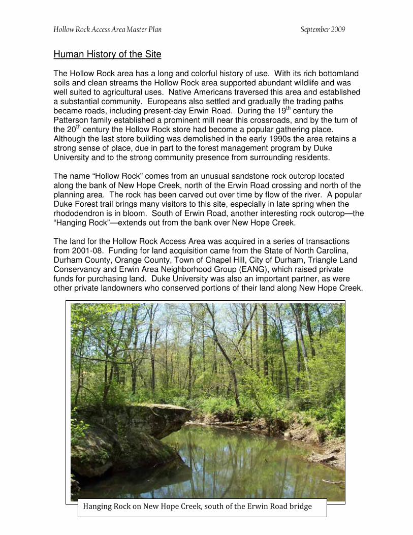
The name “Hollow Rock” comes from an unusual sandstone rock outcrop located along the bank of New Hope Creek, north of the Erwin Road crossing and north of the planning area. The rock has been carved out over time by flow of the river. A popular Duke Forest trail brings many visitors to this site, especially in late spring when the rhododendron is in bloom. South of Erwin Road, another interesting rock outcrop—the “Hanging Rock”—extends out from the bank over New Hope Creek.
The land for the Hollow Rock Access Area was acquired in a series of transactions from 2001-08. Funding for land acquisition came from the State of North Carolina, Durham County, Orange County, Town of Chapel Hill, City of Durham, Triangle Land Conservancy and Erwin Area Neighborhood Group (EANG), which raised private funds for purchasing land. Duke University was also an important partner, as were other private landowners who conserved portions of their land along New Hope Creek.
���������������� ��������������������������� ��������������

NewHopeCreek
Preserve
CHAPEL HILL
CITY OF DURHAM
Durham-Chapel HillBlvd
§̈¦I-40
§̈¦I-40
ErwinRd
Pickett Rd
MtMoriah
Rd
CambridgeRd
NewHop
e Creek
New Hope Creek
New Hope Creek
RandolphRd
K
0.25 0 0.250.125
Miles
Hollow Rock Access OverviewFigure B. Vicinity Map
OrangeCounty
DurhamCounty
Hollow Rock Planning Area
Open Space
Streams
Roads
Hollow RockPlanning Area
Thursday, September 6, 2007 12:12:57 PMH:\GIS\HollowRock\HollowRockPlanning811.mxd
Hollow Rock Planning AreaDurham and Orange County
Duke Forest

Hollow Rock Access Area Master Plan September 2009
5
Project Purpose
The New Hope Corridor Open Space Master Plan was adopted in 1991 by the City of Durham, Durham County, Orange County, and the Town of Chapel Hill. The plan called for the protection of an open space corridor along New Hope Creek and its tributary streams for recreational trails and conserving wildlife habitat. The plan identified 10 components—one of which was the “Hollow Rock Access Area.”
The Hollow Rock Access Area is intended as a community low-impact recreational area, with facilities and amenities that blend with the natural setting. The site is envisioned as a gathering place for picnics and forest walks, and for people of all ages to learn about the rich natural heritage and remarkable history of land use in the Hollow Rock community.
The site is also envisioned as an important gateway to the regional New Hope Creek trail system. Land protection along the New Hope Creek corridor extends well beyond the boundaries of the Hollow Rock Access, with 1,900 acres of the Duke Forest (Korstian Division) north of Erwin Road, and Orange and Durham counties owning over 260 acres of additional conservation land downstream of the Hollow Rock area, forming a nearly continuous corridor of open space south to Jordan Lake (Figure B).
In 2006 the four local governments signed an interlocal agreement for the planning and operation of the Hollow Rock Access Area portion of the New Hope Creek master plan. The agreement also established the advisory Committee to develop a master plan for the property. A Hollow Rock master plan committee was appointed in late 2006 and charged with developing recommendations for the types and location of facilities for the site. (See Appendix 1 for list of committee members.)
Site Characteristics
The property is entirely forested except for a two-acre clearing that has been maintained in grass following several decades of agricultural use. The forest is a combination of mature pine and mixed hardwoods bisected by a gravel section of Pickett Road. The land slopes generally to the southwest toward New Hope Creek, which forms the western property boundary. A number of small creeks flow through the middle of the site before draining to New Hope Creek.
III. Site Analysis / Opportunities & Constraints
At the initial meeting of the master plan committee, staff presented an overview of the property and a detailed analysis of the site’s features and potential limitations. The Opportunities and Constraints report summarized the history of land use, zoning and planning issues, and an evaluation of the natural and cultural features present. The following summarizes many of the key findings from that September 2007 report (for more detail, see the full Opportunities and Constraints report included as Appendix 5).

Hollow Rock Access Area Master Plan September 2009
6
The Orange County portion of the site is zoned Rural Buffer, which allows for parks and government facilities, but no public water or sewer services. Streams require undisturbed buffers up to 80 feet wide. The Durham County portion site is zoned RS-20, which accommodates parks. Streams require 50-foot undisturbed buffers.
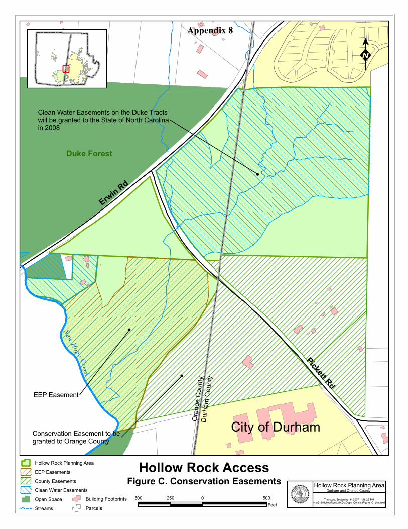
In addition to the required county stream buffers, conservation easements held by the State of NC (implemented as a result of grants to acquire the property) require 300-foot-wide buffers along streams, although some limited uses are allowed within those buffers, including natural trails with bridge crossings, boardwalks, kiosks and benches. A map of the areas protected with conservation easements is provided as Appendix 8.
Physical and Environmental Issues
The land slopes generally from the northeast (310’ elevation) down to New Hope Creek (265’) in the far southwest of the property. The eastern half of the site drains to a perennial tributary stream that flows through the middle of the property, under Pickett Road and eventually to New Hope Creek. The New Hope Creek corridor includes a narrow fringe of bottomland (100-year floodplain) that extends northeast into the site along both sides of the tributary stream. It is in this area that New Hope Creek begins to flow through the easily eroded sedimentary rock of the Triassic Basin.
Most of the site is comprised of fairly mature hardwood forest typical of the Piedmont alluvial and bottomland forest. The more upland portions of the site (generally east of Pickett Road) are suitable for nature trails, natural/cultural education, and other low-impact uses. The bottomland forest (west of Pickett Road) provides different opportunities for environmental education. Nature trails should be designed to minimize impacts to streams and bottomlands. Pedestrian bridges and boardwalks will likely be necessary to navigate portions of the property.
The New Hope Creek aquatic habitat is recognized as “state significant” due the presence of rare and endangered species of fish, crayfish, snails and mussels. The unusually high quality of this aquatic habitat will need to be protected from any potential sources of pollution. Environmental education should be encouraged, but controlled in ways that limit the disturbance of aquatic organisms and their habitats.
There are no structures on the property, except for a well-established home site on the Triangle Land Conservancy parcel. TLC uses the circa 1920 house and two outbuildings for rental income and for storing equipment. A small meadow extends from the house into the adjacent county-owned property.
Cultural and Archaeological Issues
A cultural and archaeological survey of the property was performed by Legacy Research Associates, Inc. The purpose of the survey was to identify significant cultural resources so that they could be evaluated and protected from park development. The findings of the survey would also be useful for interpreting the park property and the surrounding community.

Hollow Rock Access Area Master Plan September 2009
7
The initial survey, completed in 2007, confirmed that the area where Erwin Road crosses New Hope Creek has a long-standing tradition, rich in prehistory and history for indigenous and Euro-American settlement. Additional survey in 2008 identified areas of the park that should be restricted from development and/or protected during facility construction. Information from these surveys was conveyed to the Hollow Rock master plan committee and incorporated into the master plan.
Access and Transportation Issues
The site is highly accessible to residents of southwest Durham and from Chapel Hill via Erwin Road, Pickett Road, and other links to US 15-501. Direct access to the property could be from Erwin Road or from Pickett Road, which bisects the site.
Having portions of the park on both sides of Pickett Road not only presents more complexity for locating entrances and parking, it also creates public safety issues. The 1991 New Hope Corridor Open Space Master Plan envisioned a small parking area for this site on the west side of Pickett Road. That master plan did not, however, anticipate there being parkland on both sides of Pickett Road.
�������������������������������������������������� �������

Hollow Rock Access Area Master Plan September 2009
8
This section of Pickett Road is a gravel, state-maintained roadway between Erwin Road to the Trinity School entrance, about 1,000 feet south of the park property. The gravel road provides access to two private residences. Durham County’s 1991 Thoroughfare Plan identifies Pickett Road as a “minor thoroughfare,” and NCDOT would like to pave the road, but has received resistance from adjoining landowners.
The future use of Pickett Road was one of the most significant issues that the Committee dealt with in creating the master plan. The Committee considered the pros and cons of closing a section of the road to through traffic. More details are provided in the Findings of the Committee (Pages 10-11) and in Appendix 5.
The site’s close proximity to two schools (Forest View Elementary and Trinity School) is an important asset. It will be important to facilitate pedestrian and bicycle access to the site from both schools as well as from the adjoining residential neighborhoods.
The Solterra neighborhood shares the northernmost boundary of the parkland, and several informal trails have been created into the park property from that subdivision. One official pedestrian access point into the park would be desirable from Solterra. Similarly, a pedestrian access point and trailhead would be desirable along the eastern park boundary to connect with neighborhoods to the east. That access could be established in the future when the intervening vacant property is developed. Multiple informal access points into the Hollow Rock Access Area should be discouraged to minimize undesirable impacts along the park boundaries.
��������������������������� ������������������������ !�� ��������� ������ �����"

Hollow Rock Access Area Master Plan September 2009
9
IV. Committee Meetings and Design Process
The committee met on 12 different occasions over a year and a half period, and included design workshops (or “charrettes”) and two public input meetings. The following table summarizes the activities of the committee meetings.
Date of Meeting Activities September 18, 2007 Overview of project and charge to the committee,
review of Background information on Site, and Challenges and Opportunities report.
October 12 & 14, 2007 Site Visits October 29, 2007 Site visit debrief and discussion on additional Hollow
Rock area information. January 30, 2008 Presentation on the Cultural and Archaeological
Survey Results. Discussion on facility preferences and an update from staff on the process of closing Picket Road.
February 28, 2008 Community Input Meeting
April 10, 2008 Pickett Road discussion and report from the City of Durham Transportation staff. Continued discussion on possible facilities and preferences generated from 1/30 and 2/28 Community Input meeting.
May 29, 2008 Design Charrette June 30, 2008 Design Charrette continuation and discussion September 4, 2008 Updates on additional Cultural and Archaeological
information and Pickett Road. Review and discussion of 2 site plans schemes generated from the charrette.
November 5, 2008 Review of questionnaire responses from the committee members and of two schemes developed from the results. Presentation of a combination of both schemes into a possible draft master plan. Committee endorses the proposed draft master plan to be presented at the Open House.
December 3, 2008 (Open House)
Presentation of the draft master plan to the public for review and comment.
February 4, 2009 Review of public comments, and points to be included into master plan. Discussion on possible phasing of facilities.
March 4, 2009 Review of draft master plan and report, and discussion of desired revisions for final adoption.
Hollow Rock Access Area Master Plan September 2009
10
V. Findings
The Committee came to consensus on several basic findings that framed the creation of the draft master plan.
1. The park design should be in keeping with the original recommendations of the New Hope Creek Corridor Master Plan, the interlocal agreement, the various conservation easements, and the recommendations from the cultural and archaeological survey.
2. The uses and facilities need to be kept at a minimum and implemented using sustainable design principles to promote a natural recreational experience and have minimal impact on the natural and historic setting.
3. The meadow should remain open with no trees or permanent structures, and should be used for only for activities that are in keeping with the natural and cultural history of the site (e.g., informal play space, picnics, special events).
4. The cultural and archaeological survey provided information about the local history and significant archaeological resources found on the property. It may be prudent to conduct additional survey work prior to park construction.
5. The 2.6 acres owned by Triangle Land Conservancy (TLC) should be incorporated into the park. The land is more important than the house (ca. 1920), although recent improvements to the house might make it viable (if desired) for a caretaker residence, exhibit space, or other uses. The existing TLC shed could be used right away for sheltered picnic and educational uses.
6. The proposed new entrance from Erwin Road would require the relocation of the existing entrance used by the Fisher and TLC residences. The Fishers and TLC agree with the proposed relocation as long as they retain use of the new entrance and adequate measures are taken for their privacy and security.
7. A recombination of existing parcel boundaries (west side of Pickett Road) might benefit all parties, although such actions may require amendments to existing conservation easements held by the State of North Carolina.
8. Future trails within the park should link with other Orange and Durham county open space lands (New Hope Preserve) to the south and with existing Duke Forest trails to the north. The only sanctioned trail link to Duke Forest should be along New Hope Creek under the Erwin Road Bridge.
9. Future trails within the park should link with the Solterra subdivision located to the northeast and eventually to the undeveloped property (and Randolph Road) to the east, consistent with some future agreement with the owners of those properties.

Hollow Rock Access Area Master Plan September 2009
11
10. The former Hollow Rock Store building would be an asset to the future park. It could be used to help educate visitors about the history of the site and the neighboring community. The “Friends of Hollow Rock Store” intend to raise funds for the relocation and renovation of the building in the park (Appendix 9).
11. There are many pros and cons to closing the gravel section of Pickett Road to through traffic, but closing the road would be better for the park and its users. The process for closing a road is difficult, however, so the master plan should consider both scenarios: Pickett Road open and closed.
VI. Public Outreach and Input
Special meetings were held by the Master Plan Committee to receive public input both before and after working on the design of the Hollow Rock Access Area.
A community Open House was held on February 28, 2008 at the New Hope Improvement Center. Approximately 45 citizens were presented with an overview of the site, including the many opportunities and constraints that would influence the design of the park. People provided comments and ideas for the kinds of facilities they wanted at the future park, including a “dot voting” exercise to identify preferences.
The results indicated a strong preference toward a park theme focused on the natural and cultural heritage of the area. Facilities that received the most votes were hiking trails, paved loop trail, restroom, and opportunities for environmental education. Most people expressed interest in closing Pickett Road to through traffic. A complete list of comments (verbal and written) from the Open House is provided as Appendix A.
Hollow Rock Access Area Master Plan September 2009
12
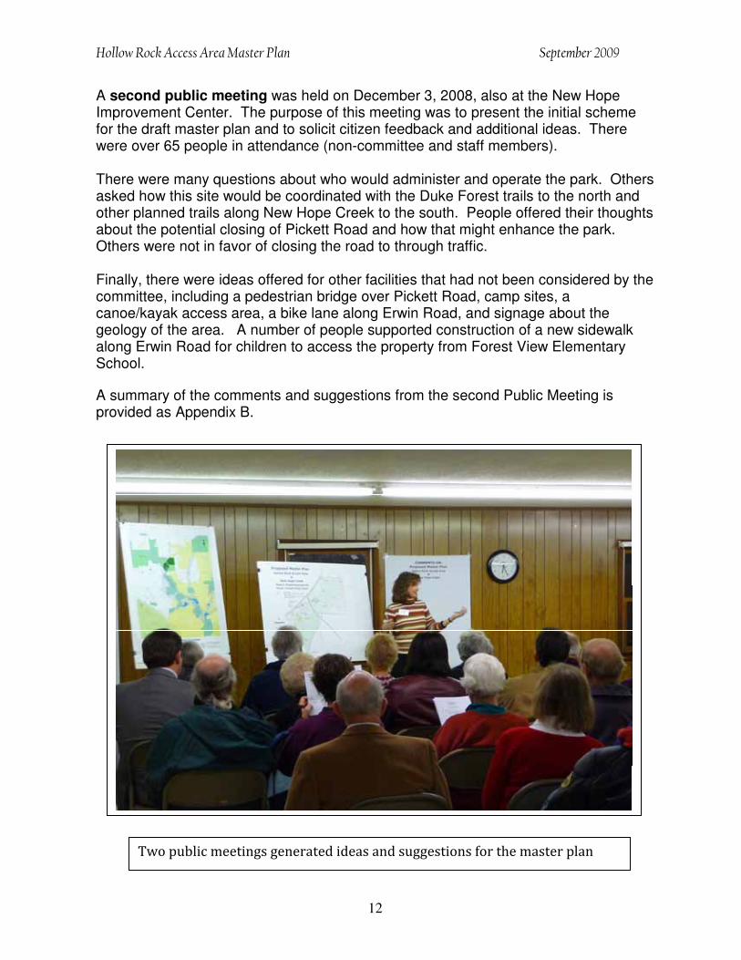
A second public meeting was held on December 3, 2008, also at the New Hope Improvement Center. The purpose of this meeting was to present the initial scheme for the draft master plan and to solicit citizen feedback and additional ideas. There were over 65 people in attendance (non-committee and staff members).
There were many questions about who would administer and operate the park. Others asked how this site would be coordinated with the Duke Forest trails to the north and other planned trails along New Hope Creek to the south. People offered their thoughts about the potential closing of Pickett Road and how that might enhance the park. Others were not in favor of closing the road to through traffic.
Finally, there were ideas offered for other facilities that had not been considered by the committee, including a pedestrian bridge over Pickett Road, camp sites, a canoe/kayak access area, a bike lane along Erwin Road, and signage about the geology of the area. A number of people supported construction of a new sidewalk along Erwin Road for children to access the property from Forest View Elementary School.
A summary of the comments and suggestions from the second Public Meeting is provided as Appendix B.
# ��������������������������������������������������������������������

Hollow Rock Access Area Master Plan September 2009
13
VII. Recommended Master Plan and Rationale
Based on its deliberations and discussions, along with public comment, the Master Plan Committee proposes the following components of the draft master plan: Master Plan Rationale
The design of the Master Plan was driven not only by the many opportunities that the site offers and the types of facilities that the committee and community desired, but also by the formidable site constraints—from the natural limitations (e.g., floodplains and significant wildlife habitats), to the special regulations and conservationeasements imposed on this site to protect the significant natural and cultural resources, to the findings of the cultural and archaeological surveys, which informed decisions about the most-appropriate locations for many activities.
Providing safe access to the site proved to be one of the major design issues in developing the Master Plan. Although the site is centrally located between Durham and Chapel Hill, access via Erwin Road is quite difficult because of the large volume of traffic and poor sight lines needed for safe ingress and egress. NCDOT representatives worked with staff to identify two potential access points, which were then evaluated by the committee and incorporated into the design. Another major obstacle (or constraint) is that the site is bisected by Pickett Road. Although most committee members favored closing a section of the road, the formal process to do so is quite long and complex. As a result, the proposed Master Plan is presented in two phases: one with Pickett Road open and one if it were ever closed. Phase One could be completed regardless of the decision to close Pickett Road. The site’s natural, undisturbed setting is its most appealing feature. The many development constraints imposed by three conservation easements and required stream buffers will protect the setting, but they also severely limit the siting of the desired park facilities. Of the park’s total 75 acres only 12 acres are not limited by conservation easements, stream buffers and areas with potential cultural and archaeological significance. Most of the proposed facilities are, therefore, located outside of those protected areas. A map of the areas protected with conservation easements is provided as Appendix 8.
The merging of the many facility preferences was the least difficult of the design issues. The committee readily agreed on the types of amenities and facilities appropriate for the site, and their ideas fell right in line with the community interests voiced at the public meetings. Hiking trails and environmental education were the overwhelming choices for the most desired activities. Other common interests were providing suitable access to the site for private vehicles, school buses, bike riders and pedestrians. Other top vote getters were a picnic area, environmental signage, informational kiosks and restrooms. Finally, the committee supported relocating the old Hollow Rock Store to the property and using it as part of the entrance to the park.

Hollow Rock Access Area Master Plan September 2009
14
Facility Priorities
Basic decisions about the type of facilities for the Hollow Rock Access Area were framed initially by the four local governments that contributed to the project, as they defined the potential uses for the property, as set forth in the Interlocal Agreement:
“The Property shall be maintained in a natural scenic condition and restricted from any development or use that would impair or interfere with the conservation purposes of the Property. The following uses are specifically declared to be consistent with the conservation purposes of the Property: open space, walking trails, parking, restroom facilities, environmental or scientific projects or studies, and other similar low-impact activities.”
In keeping with this intent and guiding principles, and after considering all the information presented, the Committee recommends the following plan for public facility improvements for the Hollow Rock Access Area of the New Hope Preserve:
1. The following facilities are recommended as top priorities for Phase 1 of the Hollow Rock Access Area (as shown on the attached Master Plan map).
• Natural surface trails • Information kiosks and other educational/directional signage • Platform overlooks for nature observation • Entrance and parking area • Pedestrian bridges for stream crossings • Bike racks • Restroom facilities (Temporary/rented “Port-a-John”) • Picnic area • ADA loop trail (1/3 mile) • Former Hollow Rock Store building (relocated to the site) • TLC property (2.6 acres), including the existing barn/shed structure
(revamped for other uses, including equipment storage, picnic tables and environmental education)
2. A Phase 2 of the master plan is proposed if and when Pickett Road is closed. It would be comprised of the following additional facilities:
• Additional parking (as the site will allow; no more than 20-24 spaces) • Restroom facilities (Permanent/vault type) • Additional loop trail and stream crossings (as necessary) • Surface improvements to the Pickett roadbed (to be re-used for parking) • Gate across Pickett Road (to prevent thru traffic, but allow access for
emergency vehicles and buses for school events)


Hollow Rock Access Area Master Plan September 2009
17
VIII. Issues for Further Study
A. Coordination of Site ManagementManagement of the 75-acre property will require a coordinated effort among the project partners—both during the interim period and after the site is open for public use. A detailed Management Plan should be developed that includes the inter-jurisdictional roles and responsibilities for park development, operation and stewardship. The Committee should continue as an advisory board for the park with meetings twice annually or as needed.
B. Closing of Pickett Road The Committee evaluated the pros and cons of closing the gravel section of Pickett Road to through traffic, and determined that closing the road would provide significant benefits to the park, including a) improved park design , b) improved visitor safety, c) reduced development costs, and d) reduced impacts on the natural environment and historic/archaeological resources. Durham and Orange counties should consider closing a section of Pickett Road (as recommended by the Committee) in cooperation with the NC Department of Transportation.
C. Further Cultural and Archaeological Discovery Recent cultural and archaeological surveys of the property revealed a great deal of useful information for the park design and potential site interpretation. The survey also determined that the site may contain additional archaeological resources of high significance. Portions of the property should remain available for further archaeological surveys in cooperation with the NC Department of Cultural Resources, and perhaps some of that work could occur prior to the construction of new facilities and opening of the park.
D. Potential Acquisition of the TLC PropertyThe Triangle Land Conservancy (TLC) purchased 2.6 acres in 2002 with the intent of establishing the Hollow Rock Access Area. The local government partners should consider acquiring the TLC property (as recommended by the Committee) and determine whether the existing house would be useful for the park.
E. Improving Public Access to the Park The Committee heard considerable public interest in facilitating public access to the site. Durham and Orange counties should consider potential road improvements, including an Erwin Road sidewalk from Forest View Elementary School and a bike lane on Pickett Road.
F. Relocating the old Hollow Rock StoreThe owners of the former Hollow Rock Store have offered the building to the park and the “Friends of Hollow Rock Store” intend to raise funds for the relocation and renovation of the building within the park. It may be necessary

Hollow Rock Access Area Master Plan September 2009
18
to allow that work to proceed expeditiously to accommodate the interests of the owner and to facilitate fundraising opportunities.
G. Assistance from Community VolunteersCitizens from the surrounding community (including the staff from neighboring schools) have offered their assistance to construct and maintain trails, kiosks, foot bridges and other amenities. The local government partners should utilize community volunteers to develop low-cost park infrastructure.
IX. Conclusion
The Hollow Rock Access Area is a place of important natural and cultural significance in the region. The primary challenge for the creation of a low-impact recreation area is to celebrate and acknowledge this location in a way that protects the resources for which it remains significant.
The site is comprised of different ecosystems that can be used for environmental education. The upland forest, the bottomland forest, the stream corridors, and New Hope Creek itself will each serve to foster a greater understanding, appreciation, and enjoyment of the natural world through environmental education.
The Hollow Rock Access Area has the potential to accommodate a variety of low-impact activities without compromising the important natural and cultural values of the property. Special care should be used to site park facilities in ways that preserve those resources. Interpretive signs that describe the different features of the property and how they fit into the history of the surrounding area are recommended. The completion of the Hollow Rock Access Area Master Plan demonstrates successful intergovernmental coordination at two levels—the purchase of shared open space, and the collaborative design of facilities for the future use and enjoyment of the site. Once the master plan has been adopted, the project partners will develop agreements for the construction and operation of the new facilities.
The third step of interlocal collaboration, yet to be written, will establish the Hollow Rock Access Area as a nature preserve, providing education and enrichment to residents of Durham and Orange counties, and for the greater region.
X. Appendices
Appendix 1: List of Committee Members Appendix 2: Preliminary Cost Estimates Appendix 3: Summary of Public Input (February 2008 Open House) Appendix 4: Summary of Comments (December 2008 Public Meeting) Appendix 5: Proposed Pickett Road Closure (Pros and Cons) Appendix 6: Opportunities and Constraints Report Appendix 7: Interlocal Agreement Appendix 8: Conservation Easements Map (Figure C) Appendix 9: Photos of Hollow Rock Store (1972 and 2006)

Hollow Rock Access Area Master Plan September 2009
19
Appendix 1
Hollow Rock Master Planning Committee
Committee Members AppointmentWendy Jacobs (Co-chair) Durham County Barry Jacobs (Co-chair) Orange County Gail Boyarsky Orange County John Goebel Durham County Alice Gordon Orange County Ed Harrison Town of Chapel Hill Becky Heron Durham County Ingrid Metcalf Orange County Ellen Reckhow Durham County Dawn Santoianni Orange County Bill Strom Town of Chapel Hill Charles Welch Durham County Mike Woodard City of Durham
Consultant Members AffiliationJudd Edeburn Duke University Leigh Ann Cienek Triangle Land Conservancy
Lead Staff AffiliationJane Korest Durham County David Stancil Orange County Marabeth Carr Orange County Beth Timson City of Durham Bill Webster Town of Chapel Hill
Other Staff/Consultants AffiliationLori Taft Orange County Perdita Holtz Orange County Greg Schuster Durham County Jeff Masten Triangle Land Conservancy John Kent New Hope Audubon Jeff Fisher Adjacent Landowner Tina Moon Orange County Rich Shaw Orange County Dan Derby Orange County

Hollow Rock Access Area Master Plan September 2009
20
Appendix 2
Hollow Rock Access Area at New Hope Preserve Preliminary Cost Estimate
(Development Only)
Cost Estimate – Phase 1A (essential elements) Low High Entrance Driveway and Parking (Gravel / HC Paved / Wheel Stops)
100,000 120,000
Site Amenities (Picnic Tables, Waste/Recycling Receptacles, and Dog Waste Receptacles)
8,000 10,000
Restroom Rental (annual) (1 year / 5 years) 2,000 10,000Additional survey work - Cultural & Archaeological and/or Topographic (Estimate)
20,000 30,000
Entrance Sign and Educational Signage (Art/Structure)
15,000 20,000Bridges – 4 stream crossings east side of Pickett Rd** 80,000 125,000Contingencies 25,000 35,000 Total $250,000 $350,000 Mid-Range $300,000
Cost Estimate – Phase 1B Low High Land Acquisition (TLC parcel)*** 96,500 96,500Platform Overlooks for nature observation** 10,000 30,000Additional Educational Signage (Art/Structure) 7,000 10,000
113,500 136,500 Mid-Range $125,000
Cost Estimate – Phase 2 Low High Parking (Gravel / HC Paved / Wheel Stops)
40,000 50,000
Pickett Road improvements (Top-dress gravel) 15,000 20,000Gate 5,000 10,000Additional survey work - Cultural & Archaeological and/or Topographic (Estimate)
10,000 20,000
Restroom (vault type) and engineering 30,000 35,000Bridges – 2 stream crossings west side of Pickett Rd** 50,000 60,000Contingencies 25,000 30,000 Total $175,000 $225,000 Mid-Range $200,000
* Assumes all trails, kiosks, bike racks are constructed by staff and volunteers ** Assumes some amount for consultant and regulatory fees and tests *** Does not include any work on existing house and outbuildings
(Estimates do not include potential costs for rock excavation or dealing with other unsuitable materials that might be found on the site.)

Hollow Rock Access Area Master Plan September 2009
21
Appendix 3
Public Input from the Community Open House February 28, 2008
I. Audience Comments and Recommendations
1. What about the west side?2. Children / Young interests / Education 3. Safe parking - easy access for buses and pedestrian 4. History of area - long-term human occupation 5. Pedestrian Bridge 6. Low impact trails - Loop and Linear 7. Conservation Lands / Ecological 8. Endorse closing Picket Road - Compromise public use options 9. Closing Pickett Road - Compromise public use options 10. Close Pickett Road – could use part of the roadway for parking 11. Adjacent Landowner - Impacts of public use on residence (trails, privacy) 12. Trash Dump - Environmental Issue 13. Integrate old Hollow Rock Store - Possible locations 14. Visual Buffer / Natural Boundary 15. Bird Watching Platforms - Near trails or stream 16. Don’t duplicate/triplicate Botanical Gardens/Education 17. Educational displays of poisonous species 18. Working steam-powered sawmill with whistle 19. Small Amphitheater 20. Outdoor Classroom 21. Historic Roads Trading Path 22. Water Quality / Habitat 23. Diversity of Species 24. Geology 25. Duke Forest neighbor 26. Connects to Jordan Lake - Regional Implications27. Involve area Churches 28. April 8 celebration of Durham County’s purchase of Duke property
II. Written Comments in response to questions
What kinds of facilities (or experience) would you most want to have at this public area? • Follow the interlocal agreement to foster the conservation purposes of the property. • Education, Education facilities, amphitheater, classroom, old store • Hiking Trails, Bird watching platform • Low Impact, Bring back the Hollow Rock Store • Hollow Rock Store • Trails, Shelter or building for Environmental Education Programs & Cultural & Historical

Hollow Rock Access Area Master Plan September 2009
22
• Natural – A couple of trails, low impact. An outdoor classroom for Forest View Elementary. Maximum 4 picnic tables – good for school to do outdoor art projects.
• Parking access to trail going downstream toward Jordan Lake as well as access to a pedestrian bridge over Erwin Road to Duke Forest.
• Meeting place for classes, simple education sites, museum, field guides unique to this site (our school can help), bathrooms
• 1. Preservation and educational pieces related to the rich cultural and environmental history of the area. 2. Hiking Ability to join various trails together and link up with Duke Forest trails so hikers can do longer hikes (over 3 miles…even 10 or 12 miles). 3. A primitive backcountry style campsite or two (Like the new ones at Eno River Pipers Creek Campground)
• Well maintained hiking trails, benches along the way for sitting/enjoying the scenery, a rustic assembly shelter surrounded by forest for discussions, food and drink and concerts, a facility free of motorized vehicles of any kind, interests of children/young people should dominate.
Do you feel closing Pickett Road to through traffic would be positive or negative? • Definitely negative. Pickett Road is a thoroughfare according to the staff presentation and the
public needs this east-west access. Instead use a pedestrian bridge over Pickett Road. It is not likely that the state will close the road in any case.
• Negative. Close road. Consider options for access that would allow buses from other communities.
• Positive • Yes • Positive. Would still like access from Erwin Rd if possible without a stop light- otherwise, just
close and get access another way. • Positive • Positive. I’m very sick of seeing all the trash, including things like mattresses, couches,
garbage cans and hit dead deer! Hooligans drive into the woods and still go hunting. Needs to be closed.
• Very Positive, an opportunity for parking area • Hiking, History Museum • Positive. Very dangerous intersection with Garrett Rd, Add traffic light at Randolph and Erwin. • Positive. Great for access to both sides of road, great for parking, safer for pedestrians, not
longer a traffic hazard on Erwin Road. • Positive. Do it! • Definitely positive. For many reasons. The exit from Pickett Road onto Erwin Road is extremely
dangerous and the Park needs to be free of the traffic.
III. Results from the Dot Voting Exercise
Focus on Historic and Cultural History (30 dots total) 6 Amphitheater & Outdoor Classroom 2 Simple identification of what is there 6 Incorporate TLC structures into the site 1 Birding Tower 1 Program for school kids to come from urban areas and neighboring schools 14 Placed in general on sheet
Comment: Emphasize study of aquatic insect / invertebrate life as indicator of water quality
Facilities for Environmental Education (25 Dots Total) Comment: This is what makes this area unique, as compared to other outdoor facilities

Hollow Rock Access Area Master Plan September 2009
23
Large Group Shelter (9 Dots Total)1 Add onto the existing Triangle Land Conservancy shed 2 Needs to be a meeting place for schools 2 Art place 4 Placed in general on sheet Comment: Concept; needs to be defined
Hiking Trails (30 Dots, all placed in general on sheet) Comment: Develop trail start to Jordan Lake
Restrooms (10 Dots, all placed in general on sheet)
Accessible Trail Loop (17 Dots, all placed in general on sheet) Comment: Variety of trails/lengths Comment: Highlight habitat types (e.g., Ferns, Rock Formations, Wetlands)
Picnic Area(s) (5 Dots Total)5 Small picnic area Comment: Who will patrol the site for trash removal?
Open Play Meadow (8 Dots Total)Comment: Add the bird watching platform
Other - Close Pickett Road (30 Dots, all placed in general on sheet) Comment: Explore a parking development along a closed Pickett RoadComment: Bring Hollow Rock store home…. near Pickett Road

Hollow Rock Access Area Master Plan September 2009
24
Appendix 4
Summary of Comments from Public Meeting December 3, 2008
1. Connection to Duke Forest 2. Who will administer / operate the new park? 3. Pickett Road rationale 4. Pedestrian bridge desirable if Pickett Road not closed 5. Dangerous intersection at Pickett and Erwin 6. Trails liaison/coordination 7. Campsites (for young people) 8. Educational information on artifacts (i.e., what to do if you find one) 9. Use for the old store building? 10. Who will run the park? Hours of operation? 11. Recommend no lighting 12. Canoe / Kayak access? Downstream? Portage 13. Volunteer Trail Work 14. Overflow parking west side of New Hope Creek 15. Sue Whitfield – artifacts from the old store 16. Access to undeveloped land to the east 17. Lock in access to subdivisions / Parking 18. How will Duke Forest and Hollow Rock work together to coordinate trails? 19. All weather passage under bridge needed to Duke Forest trails (coordinate) 20. Recommend signage about the geology, including Triassic Basin 21. What about funding? 22. Volunteer trail work 23. Could the site eventually become part of State parks network? 24. Will Pickett Road remain dirt? How about parking spaces? 25. Sidewalk to connect to Forest View Elementary School. Funding? 26. Will people come by bike? 27. Bike trails to Jordan Lake – Can there be connections? 28. Should the plan construct the view for a biker – Durham side? 29. Request Bike route along Erwin – DOT 30. Questions about the State conservation easement restrictions (EEP / CWMTF)

Hollow Rock Access Area Master Plan September 2009
25
Appendix 5
Proposed Pickett Road Closure Pros/Cons Discussion Points (4/10/08)
Background
This document is a compilation of the Pros and Cons for closing Pickett Road between Randolph Road and Erwin Road, as provided by City of Durham Transportation Division, Durham City/County Planning and Orange County Planning.
Pros
Safety• Bisects the Park – There is a safety issue to those trying to cross the road to get from
one area of the park to another, especially for groups of school children. • Cars tend to drive too fast on this road and use it regularly as a cut through despite the
fact that it is dirt. • The uneven nature of the existing roadbed could cause a speeding car to easily lose
control. • There is no definition as to the width of the road. As a result of not having a defined
shoulder area, there isn’t a safe area for walking or biking. • The NCDOT does not have a track record for installing traffic calming on state
maintained roads (Pickett Road is a state road). If Pickett Road is improved, (i.e., paved) and draws more traffic, it may be difficult to have traffic calming measures installed.
Aesthetics• Closing the road would enhance the natural open space experience by limiting noise,
pollution, hazards and other negative impacts from nearby traffic. • The dirt roadbed and speeding traffic cause large amounts of dust. The dust penetrates
deep into the woods, coating the vegetation and posing a potential health hazards by causing lung, eye and/or skin irritation.
• The road has been used as an illegal trash dumping site, which will probably continue if the road remains open.
Access/Parking• It is a duplicate road. Randolph Road is parallel road that is less than a ½ mile away.
Patrons of the adjacent private school, which also has access to Randolph Road, are the main use of Pickett Road.
• The NCDOT might not permit parking along this public road.
Page 1 of 2

Hollow Rock Access Area Master Plan September 2009
26
Cons
Connectivity• West of 15-501, there are only three connections between Erwin Road and Pickett
Road; these connections are Pickett, Randolph, and Ridge. There appears to be little chance of additional connections as new development occurs, and these connections become more important considering the two schools on Pickett Road.
• Subsequent reduction in connectivity is against local policy to support increased connectivity.
Access• The immediate adjacent property owner is not Trinity School, and accessibility to the
Trinity School will be impacted. • The use permit for Trinity School may include language to prevent the road closing. • All adjacent properties would need frontage on a public road after the road closing. • NCDOT would need to issue a driveway permit if the road were closed, but might be
opposed to approving such a permit.
Impacts of Traffic Diversion• Randolph Road and all intersections from Pickett Rd. to Randolph Rd. and to Erwin Rd.
do not have the capacity to handle the increased traffic. • There is not ample storage on Randolph Road to handle an increase in left turns. • Right turns at Randolph will pose safety issues.
Emergency Vehicle Response Time• Law enforcement, fire and EMS response times might be affected by a road closure.
Thoroughfare Plan• Pickett Road is a minor thoroughfare in the 1991 Thoroughfare Plan. It will be difficult
to close a road on the Plan. The Plan will be updated with the 2035 Long Range Transportation Plan.
• There is not an established precedent for closing a minor thoroughfare. • Traffic would be re-routed to Randolph Road, which is not a minor thoroughfare.
Other Issues• The road is not paved and there are only 420 daily vehicle trips (based on NCDOT
count in 2005). Traffic calming might not be needed at this point. • The logistics of closing the road would involve coordinating two NCDOT district
engineer offices to remove from state maintenance. • If abandoned, Durham County might not be able to request NCDOT paving for the
road.
Page 2 of 2

Hollow Rock Access Area at
New Hope Creek
Opportunities and Constraints
September 18, 2007
Durham County Open Space and Real Estate Division Orange County Environment & Resource Conservation Department
Appendix 6

Hollow Rock Area / New Hope Creek Opportunities and Constraints
i
Table of Contents
Page
I. Background ……………………………………………………… 1
II. Planning and Zoning …………………………………………… 2
III. Surrounding Land Uses ………………………………………… 3
IV. Location and Access ……………………………………………. 3
V. Property Description ……………………………………………. 4
VI. Cultural and Archaeological Survey ……………………………. 5
VII. Opportunities and Constraints ………………………………….. 6

Hollow Rock Area / New Hope Creek Opportunities and Constraints
Page 1 of 8
I. Background
The planning area is located south of Erwin Road (SR 1734) near the intersection with Pickett Road (SR 1303). It extends from New Hope Creek eastward approximately 1,000 feet beyond the Orange and Durham county boundary. The 75-acre planning area is comprised of multiple parcels of land owned by Orange County, Duke University or the Triangle Land Conservancy. The property presently owned by Duke University is under contract for purchase by Durham County, Orange County and the Town of Chapel Hill in April 2008. The planning area consists of approximately 42.75 acres in Orange County and 32.15 acres in Durham County. A vicinity map (Figure A) and a site map (Figure B) are attached.
The planning area is completely forested with a combination of mature pine and mixed hardwoods except for a two-acre clearing for a home site located on the Triangle Land Conservancy parcel. The land slopes generally to the southwest toward New Hope Creek, which forms the western property boundary. Small creeks flow through the middle of the site before draining to New Hope Creek.
Land protection along the New Hope Creek corridor extends beyond the boundaries of this parkland planning area. Duke University manages 1,900 acres of the Duke Forest (Korstian Division) north of Erwin Road and adjacent to New Hope Creek; Orange County and Durham County own over 260 acres of additional conservation lands downstream of the Hollow Rock Access area, with a nearly continuous open space
corridor to Jordan Lake.
New Hope Corridor Open Space Master PlanThe planning area was acquired to support the implementation of the New Hope Corridor Open Space Master Plan, which was adopted in 1991 by the governing boards of Durham, Chapel Hill, Durham County, and Orange County. The master plan called for the protection of an open space corridor along New Hope Creek and its tributary streams for recreational trails and conserving wildlife habitat. The master plan identified 10 geographic areas—one of which was the “Hollow Rock Access Area” (Appendix 1).
The “Hollow Rock” area along New Hope Creek has a long and colorful history of use dating back to the pre-Colonial period. There is evidence of significant Native American presence, an historic crossroads, the farming of rich bottomland soils along the creek, the former Patterson mill and Hollow Rock store, large-scale timber management in Duke Forest, and the ongoing use of the New Hope Creek corridor by the people and wildlife in the Hollow Rock community.
The name “Hollow Rock” comes from an unusual sandstone rock outcrop located along the bank of New Hope Creek, north of the Erwin Road crossing and north of the planning area. The rock has been carved out over time by flow of the river. A popular

Hollow Rock Area / New Hope Creek Opportunities and Constraints
Page 2 of 8
Duke Forest trail brings many visitors to this site-- especially in late spring when the rhododendron is in bloom.1
The New Hope Creek Corridor Advisory Committee (NHCCAC) was created in 1992 to advise the four local governments regarding implementation of the New Hope Corridor Open Space Master Plan. The committee continues to serve in that role and is supportive of establishing the Hollow Rock Access Area.
Land AcquisitionThe project area was acquired in a series of transactions from 2001-07. The Triangle Land Conservancy (TLC) purchased the first two acres in 2002, and then advocated for further acquisitions by local government partners. Orange County purchased a 7-acre parcel from Duke University in 2006 and a 22-acre parcel from Wade and Carolyn Penny in 2006. [TLC obtained a grant from the State of N.C. for the Penny tract.] The purchase of a 43-acre tract from Duke University by Durham and Orange counties and the Town of Chapel Hill was committed to in April 2005, and will be purchased in April 2008. Additional funds for that purchase came from the City of Durham, the State of N.C., and the Erwin Area Neighborhood Group (EANG). The State awarded grants for the purchase of the 43-acre Duke tract and the 22-acre Penny tract. Both grants required that the sites be protected with permanent conservation easements. EANG raised $200,000 in private funds toward the local governments’ purchase of the 43-acre Duke tract. These privately pledged funds were collected and administered by TLC.
Interlocal Agreement In September 2006, the four local governments signed an interlocal agreement for the acquisition, planning and operation of the Hollow Rock portion of the New Hope Creek master plan. The agreement also established a “Park Planning Advisory Committee” to develop recommendations for an overall plan for the Hollow Rock area property.
An 11-member Hollow Rock master plan committee was appointed in late 2006 and charged with developing recommendations for the types and location of facilities within the Hollow Rock Access Area. It is expected that the future park will be designed in ways that will maintain the site’s natural, cultural and scenic values.
II. Planning and Zoning The subject property is split by the Orange-Durham county boundary (Figure B).
The Orange County portion of the site is classified as Rural Buffer. According to the Comprehensive Plan, development in the Rural Buffer should avoid areas where it would have a detrimental effect on state or federally recognized historic-cultural sites or to unique or endangered plant and animal species. Permitted uses include parks, schools, and government facilities. Residential development is allowed at a maximum density of one dwelling per two acres. No public water or sewer services are permitted. Any streams in Orange County recognized by the Planning Department require 65-foot-
1 South of Erwin Road, there is another interesting rock outcrop—the so-called “Hanging Rock,” which
extends out from the bank high over New Hope Creek. Hanging Rock is on the portion of Orange County’s New Hope Preserve that was acquired from the Penny family in 2006.

Hollow Rock Area / New Hope Creek Opportunities and Constraints
Page 3 of 8
wide undisturbed buffers (Resource Protection Areas). The site is within the Cape Fear River Basin (New Hope Creek sub-basin), but is not within a watershed protection overlay district identified in the Orange County Zoning Ordinance.
The Durham County portion of the site is zoned RS-20, single family residential with 20,000 square foot lots. Perennial and intermittent streams on the Durham portion of the planning area require 50-foot undisturbed buffers.
In addition to the required local government (i.e., county) stream buffers, existing or future conservation easements held by the State of NC require 300-foot-wide buffersalong those same streams.
III. Surrounding Land Uses The planning area is surrounded by a combination of undeveloped and rural residential properties, but suburban residential development occurs less than ½ mile to the southeast. The portion of the site in Orange County is bordered to the west by New Hope Creek and the Fisher residence (1.7 acres; private), to the north and west by Erwin Road and Duke Forest, and to the southeast by private lands owned by Wade and Carolyn Penny for which a conservation easement is in progress. The portion of the site in Durham County is bordered on the north by the Solterra residential development, to the east by a 20.5-acre undeveloped tract, and to the south by additional land owned by the Pennys (18.5 acres; private), which has limited development potential by virtue of conservation easements granted to Durham County. Further south on Pickett Road (past the Pennys) are Trinity School and the Hope Creek and Garrett Farms residential subdivisions.
An aerial map of the property and surrounding area is provided as Figure D.
IV. Location and Access The property is situated midway between Durham and Chapel Hill along Erwin Road (SR 1737)—a well traveled east-west roadway, and within two miles of the I-40 interchange with US 15-501 (Durham to Chapel Hill Road). Access to the property can be either on Erwin Road or from Pickett Road (SR 1303), which begins at Erwin Road about 1,000 feet north of the New Hope Creek bridge crossing. This western end of Pickett Road is a fairly narrow gravel roadway from Erwin Road to the intersection with Cambridge Road. Pickett Road bisects the Hollow Rock park property and provides access to two residences above the Cambridge Road intersection.
The New Hope Corridor Open Space Master Plan envisioned a small parking area on the west side of Pickett Road. Orange County acquired the 7-acre property located at the corner of Erwin and Pickett roads for that purpose. The master plan did not, however, anticipate the acquisition of land east of Pickett Road. Because the property is on both sides of Pickett Road there needs to be further consideration of where to locate the park entrance(s) and parking area(s). Pedestrian access to the property from nearby residential neighborhoods and schools should also be considered.

Hollow Rock Area / New Hope Creek Opportunities and Constraints
Page 4 of 8
V. Property Description
Land CoverThe property is almost entirely forested with mature loblolly pine and mixed-aged hardwoods. There is one small open area (+ 2 acres) that straddles the boundary between the Triangle Land Conservancy and Orange County landholdings. That location has been maintained as a home site and small field for over 80 years.
The forested area includes three stands of mature loblolly pine—one adjacent to Erwin Road, west of Pickett Road (+ 6 acres); one adjacent to the Penny property, west of Pickett Road (+ 2 ac.); and one along the southern boundary of the Duke tract, east of Pickett Road (+ 5 acres). The pines average from 15 to 18 inches in diameter (dbh).
Most of the forest is comprised of fairly mature hardwoods typical of the Piedmont alluvial and bottomland forest. The more upland portion of the site (east of Pickett Road) is comprised of a variety of tree species such oak, hickory, sweetgum, maple and mature pine. Numerous hardwoods are over 18 inches in diameter (dbh).
The lower-lying areas (west of Pickett Road) include river birch, sycamore, box elder, Shumard oak, shagbark hickory, tulip tree, and sweet gum. The soils are fairly rich in this area, as indicated by the abundance of sugarberry, Florida maple, ash, slippery elm, eastern hop-hornbeam, painted buckeye, and pawpaw. There are small areas with invasive exotic plants (e.g., Chinese privet, multiflora rose, and Japanese stilt grass), but much less than is found on the conservation lands located downstream. The excellent condition of the riparian forest, and its connection to other conservation lands upstream and downstream, enables this property to serve as excellent habitat for wildlife, including white-tailed deer, bobcat, northern river otter, wild turkey, barred owl, red-shouldered hawk and a large variety of other birds.
Topography and HydrologyThe land slopes generally from the northeast (310 feet elev.) down to New Hope Creek (265 feet) in the far southwest of the property. The New Hope Creek corridor includes a narrow fringe of bottomland within the 100-year floodplain. That bottomland (and floodplain) extends to the northeast into the site along an unnamed tributary stream, almost to where the stream flows under Pickett Road. A topographic map is provided as Figure E.
The unnamed New Hope tributary flows through the middle of the property in a southwesterly direction. The property slopes from both sides to the tributary. Two or three wet weather (ephemeral) streams drain the northeast portion of the site, carrying rainwater to the tributary and eventually to New Hope Creek.
The North Carolina Natural Heritage Program recently designated this section of New Hope Creek as having aquatic habitat of state significance, due to the presence of rare and endangered species of fish, crayfish, snails and mussels. A biologist field report for the natural area is provided as Appendix 3.

Hollow Rock Area / New Hope Creek Opportunities and Constraints
Page 5 of 8
SoilsSoil Survey maps of Orange and Durham counties identify a variety of soil types within the planning area. The northeast (upland) portion of the site has White Store clay loam—moderately well drained soil found on ridges and the sides of narrow upland slopes. Slope, erosion, surface runoff, and slow permeability are the main limitations to its use and management. The potential for urban, cropland and active recreation uses is low. Most areas with this soil are used as woodland, as has been the case for this site. The southwest (lowland) half of the property has bottomland soils (Creedmoor and Congaree fine sandy loam) with low potential for most urban uses. The Congaree soil is associated with floodplain along New Hope Creek and the unnamed feeder stream. The Creedmore soil is located on the northwest portion of the site, adjacent to Erwin Road. Sometimes used for cropland and pasture, the soil has moderate potential for active recreation use. A soils map of the property is provided as Figure F.
Existing Structures and ImprovementsThere are no structures on the property, except for a well-established home site located on the Triangle Land Conservancy parcel. The site includes an old house (ca. 1920) and small outbuildings, which TLC uses for rental income and for storing equipment. A small field (+ 1 acre) extends from the house into the Orange County preserve. That field has been maintained for agricultural uses over the past 80 years or more.
A walking trail enters the western half of the property from Pickett Road and winds its way down to New Hope Creek. The trail was created as a “temporary trail” in 2005 to enable local elected officials and state grant officials to tour the site prior to acquisition. Since then visitors from the neighborhood and nearby Forest View Elementary School have used the trail for periodic visits to New Hope Creek. A second walking trail enters the eastern half of the site from Pickett Road. The short trail follows the riparian corridor upstream before looping back through the upland forest and back to the road.
A small remnant portion of the former Hillsborough-Fayetteville road remains visible, immediate southwest of the intersection of Erwin Road and Pickett Road. The old road and its significance will be described in the cultural and archaeological survey.
VI. Cultural and Archaeological Survey Legacy Research Associates, Inc. was selected in September 2007 to conduct a cultural and archaeological survey of the planning area. The purpose of the survey is to identify and evaluate significant cultural resources located on the property so that they will be protected from park development and available for future interpretation of the site.
The survey is scheduled to be completed in November 2007. The final report will reference previously recorded archaeological sites and describe any new sites identified by this new survey. A summary of the survey findings and recommendations will be presented to the Hollow Rock park master plan committee.
Hollow Rock Area / New Hope Creek Opportunities and Constraints
Page 6 of 8
VII. Opportunities and Constraints
The Hollow Rock parklands were acquired for the purpose of protecting this segment of the New Hope Creek corridor for low-impact recreation, environmental education and wildlife habitat—all consistent with the New Hope Corridor Open Space Master Plan.
The land was acquired by several conservation partners, including the State of North Carolina that contributed funds through the NC Clean Water Management Trust Fund (CWMTF) and the NC Ecosystem Enhancement Program (EEP). Both of those grant programs required that the lands be protected with permanent conservation easements that prohibit all but a few uses of the property. A summary of the two conservation easements is provided as Appendix 2.
The Hollow Rock parklands could accommodate a variety of low-impact activities without compromising the important natural and cultural values of the property. Special care will be needed when siting and designing those facilities. Interpretive signs could be used to describe the different features of the property and how they fit into the history of the site and the surrounding areas.
The site is comprised of different ecosystems that could be used for environmental education. The upland forest, the bottomland forest, the stream corridors, and New Hope Creek itself could each serve to foster a greater understanding, appreciation, and enjoyment of the natural world through environmental education. Examples of potential programs include birding, stream ecology, wildlife discovery, reptiles and amphibians, butterflies and caterpillars.
The following is a list of specific opportunities and constraints that have been identified for the property thus far. Please note that some items are listed under both categories.
A. Opportunities:
1. Access – The site is highly accessible to residents of southwest Durham and Chapel Hill via Erwin Road, Pickett Road, and other links to US 15-501.
2. Mature Upland Forest – many of the forested areas are suitable for nature trails, environmental education, and other low-impact uses. Perimeter forest areas will help to buffer adjacent private properties from future park activities.
3. Bottomland Forest – the lower forest (west of Pickett Road) is in excellent condition, and provides opportunities for environmental education. Nature trails through the wetter areas should be properly designed, including bridges and boardwalks. Signage should advise people how to avoid harming the flora and fauna in this area.
4. New Hope Creek Aquatic Habitat – the unusually high quality of this aquatic habitat provides an opportunity for people to learn about rare and endangered organisms living in New Hope Creek (e.g., fish, crayfish, snails and mussels).

Hollow Rock Area / New Hope Creek Opportunities and Constraints
Page 7 of 8
5. Historic and Archaeological Sites – The information gathered from the current survey will likely be useful for interpreting the property and the surrounding community. [e.g., remnants of the former Hillsborough-Fayetteville road]
6. Proximity to other Facilities – The site’s close proximity to other publicly accessible facilities is an asset that should be considered in determining the future use of the property. Nearby facilities include the Trinity School and Forest View Elementary School.
B. Constraints:
1. Access – Pickett Road (SR 1734) bisects the property so the master plan will need to address parking and access to parkland on two sides of the public road.
2. Adjacent residences – There are a few homes located adjacent to the site. The design of the park and its facilities should consider the potential effects on those neighbors (Fisher, Penny and the Solterra subdivision).
3. Historic and archaeological resources – The current cultural/archaeological survey might identify areas on the property that should be avoided or protected from any uses, including trails.
4. Streams – Undisturbed buffers (300-feet-wide) are required along New Hope Creek and its tributary streams, consistent with conservation easements held by the State of North Carolina. The conservation easements allow limited facilities, such as nature trails with bridges, boardwalks and benches.
5. New Hope Creek Aquatic Habitat – the unusually high quality of this aquatic habitat must be protected from any potential sources of pollution. Environmental education should be encouraged, but limited so as not overly disturb the organisms in New Hope Creek (e.g., fish, crayfish, snails, mussels).

Hollow Rock Area / New Hope Creek Opportunities and Constraints
Page 8 of 8
List of Figures
Figure A Vicinity Map Figure B Site Map Figure C Conservation Easements Figure D Aerial Map Figure E Topographic Map Figure F Soils Map
List of Appendices
Appendix 1 New Hope Corridor Open Space Master Plan, Hollow Rock Access Area (Component 6)
Appendix 2 Summary of the Conservation Easements held by State of NC Appendix 3 Site Report, New Hope Creek Aquatic Habitat (NC Natural
Heritage Program) Appendix 4 1938 Aerial photo of the Hollow Rock area

Appendix 7


City of Durham
Duke Forest
ErwinRd
Pickett R
d
NewHopeCreek
K
500 0 500250
Feet
Hollow Rock Access
OrangeCounty
DurhamCounty
Thursday, September 6, 2007 1:48:23 PMH:\\GIS\HollowRock\MXDs\Opps_Consts\Figure_C_site.mxd
Hollow Rock Planning AreaDurham and Orange County
Conservation Easement to begranted to Orange County
Clean Water Easements on the Duke Tractswill be granted to the State of North Carolinain 2008
Hollow Rock Planning Area
EEP Easements
County Easements
Clean Water Easements
Open Space
Streams
Building Footprints
Parcels
EEP Easement
Figure C. Conservation Easements
Appendix 8

Appendix 9
Hollow Rock Store – Then and Now
The old store now located on the property of Jan Gregg (photo by Rich Shaw)
John Brown’s Store in Winter 1972 (photo by Steve Heron)