
Hohe_Tauern.pdf
2
Hiking destinations Carinthia 1 Nature Trail Gamsgrube CARINTHIA Unique panoramic route that is reached from the Kaiser Franz Josef peak through the so-called “treasure tunnel” (exhibition on the subject of water, gold and crystal). With- out any steep slopes, the path leads above the largest glacier in the Eastern Alps, the Pasterze, giving a magnificent view of the Großglockner to the Gamsgrube. There is an ecologically sensitive drifting sand areas with vegetation that resembles that in central Asia or the Arctic (it is forbidden to leave the path!). After one has passed the splendid resting place at the waterfall spot, the path ends immediately at the glacier edge of the waterfall Winkelkees. (National Park hike bus) Starting Point: Car park Kaiser-Franz-Josefs-Höhe (2.369 m) Approach: Via the Großglockner High Alpine Road (toll road) Walking Time: 2 hours to the Winkelkees waterfall 2 Pasterze Glacier Trail CARINTHIA Starting from the Glocknerhaus Alpine Centre, the glacier trail leads to the ecologically very interesting area before the Pasterze glacier, the largest glacier in the eastern Alps. Here, there are all the shapes left behind by the freezing, such as round stools, moraines and slabs of rock ground smooth by the glacier. After passing past a goldvein, one finally reaches the still impressive glacier tongue of the Pasterze! WARNING: the glacier should only be entered in the area approved for this purpose, danger of falling into a hidden split in the ice! (National Park hike bus) Starting Point: Parking area of the Glocknerhaus Alpine Centre (2.131 m) Approach: Via the Großglockner High Alpine Road (toll road) Walking Time: 3 hours from the Glocknerhaus to Kaiser-Franz-Josefs-Höhe 3 Gößnitz Falls - Kachlmoor CARINTHIA Gößnitz Falls is among the mightiest waterfalls in the whole national park and lies in the middle of an impressive ravine at the start of Gößnitz valley. This grandiose spectacle of nature is revealed by following a nature trail to a panoramic viewpoint. The Kachlmoor is another of the highlights of this easy trail. This swamp, which was formed due to an avalanche after the receding of the late ice-age Pasterze, is now a very important habitat for amphibians (grass frogs, yellow-bellied toads) in the Hohe Tauern. (National Park hike bus) Starting point: Retschitzbrücke parking area (1,260 m) in Heiligenblut Approach: municipal road, some 100 metres from the town centre of Heiligenblut Walking time: 2 hours 4 Briccius Chapel CARINTHIA The Briccius Chapel (1,629 m) is a place steeped in history because the chapel, the first documentary evidence of which goes back to the year 1271, is regarded as the place where the Holy Briccius died. According to the saga, he is meant to have brought the blood of Christ to Heiligenblut. The chapel is the end-point of the “Briccius healing water trail”. This leads past the botanical gem of the “Sattelalpe alpine flower slope” and by a breathtaking viewing platform to the chapel and its healing spring, which is meant to ameliorate eye complaints among other things. (National Park hike bus) Starting Point: Kräuterwandstüberl parking area (1.421 m) in Heiligenblut Approach: Municipial road, approx. 3 km from Heiligenblut town centre Walking Time: 1.5 hours to the Briccius Chapel 5 Gößnitztal - Langtalseen CARINTHIA With the Gößnitz waterfall (see Tour 3) as an impressive “guardian” at the entrance to the valley, the Gößnitz Valley is one of the most beautiful alpine valleys in Hohe Tauern. This long tour (it is recommended that you stay overnight in at the Elberfelder Hütte) leads over the large, still-grazed alpine pastures to the Elberfelder Hütte (2.346 m) where the valley ends in high mountains and glaciers. Then it's back into the heights, with plenty of views, on a trail that connects three alpine lakes, the Long Valley Lakes. At the Wirtsbauer pasture, one rejoins the main path leading down to Heiligenblut. (National Park hike bus) Starting Point: Retschitzbrücke parking area (1,260 m) in Heiligenblut Approach: Municipial road, a few 100 metres from Heiligenblut town centre Walking Time: 12 hours (overnight stay at the Eberfelder Hütte is recommended!) 6 Great Fleiß valley CARINTHIA Taking the local cableway you first reach the Schareck peak - here you start the ascent on a well prepared trail upwards to the Seppen pastures. The route continues still along a sign- posted trail up to Weißenbach, then towards the valley up to a stream called Großer Fleiß- bach . At the valley bottom you walk along the trail up to the end of the valley, past the “Fleiß” ski lifts until you reach the turn-off at the old rivers; here you must take the right, in the direction of the lodge “Fleißwirt”. Shortly before you reach this place, turn to the right again, cross the Fleiß hamlet and finally walk back to Heiligenblut. (National Park hike bus) Starting point: valley station of the Großglockner lifts in the centre of Heiligenblut Walking Time: approx. 3 hours 7 Großes Zirknitztal CARINTHIA The Große Zirknitztal was incorporated into the protected area in 2001. Quite rightly so, because one could hardly hope to see a more beautiful glacier-formed, U-shaped val- ley. For centuries, there was also gold mining in the valley. A splendid hiking trail inclu- des the pine-covered valley up to the historic “pay table” (2,114 m), where the miners were once paid for their hard work underground! Then one walks up to the soft corner pastures, with a view of the Großglockner, to then return via the “Färber Kaser” to the starting point. (National Park hike bus) Starting Point: Großes Zirknitztal parking area (1,700 m) at the end of mountain road Approach: Exit from the Mölltal main road in Döllach and onto mountain road via the village of Zirknitz into Große Zirknitztal Walking Time: 4 hours via “Zahltisch” and the Eckalmen 8 Stanziwurten CARINTHIA Thanks to the recent opening of the track on the Mittner mountain pastures it is now possible to reach the fantastic Stanziwurten (2.707m) panoramic peak on a pleasant all-day hike. The ascent begins at the mountain village Mitten (accessible either from Heiligenblut or from Döllach) on a pleasant, well prepared road up to the new parking area Mittner Almen. From here the hike continues on a wonderful path through an im- pressive landscape with panoramic view to the Großglockner and the Schober group towards the small Tröger mountain pastures. The last stretch of the path becomes a bit steeper up the first small peak dominated by a big cross, then in a few minutes you reach the main peak. The descent through the Südkamm is more direct. Starting Point: Mittner Almen parking area Approach: from Mitten along the Mittner Almen track Walking time: 5 hours (ascent and descent) 9 Loop hiking route Ranach - Gartltal CARINTHIA Starting from the idyllic mountain hamlet of Ranach you first wander along a pasture trail, then you keep on walking upwards on a path along the Moosgraben crossing the Gartl stream until you finally reach the Gartl pastures (1.763 m). From the area called “Fleckmoos“ take the mule track until you get to the Wetterkreuz peak (2.120 m). Once here, experienced mountain hikers should not miss a prolongation of the route to the Gartlkopf peak (2,458 m; 1 hour). You then continue upwards crossing the Schober pastures (1,740 m) and finally walk back to Ranach. Starting point: Ranach (1,353 m) Access: Döllach (Großkirchheim) – hamlet Kraß – road to Ranach Walking time: approx. 4,5 hours (ascent and descent) 10 Winklerner Alm - Strasskopf CARINTHIA The Winklerner Alm is a gentle pastoral landscape just above the forest limit. From here the Strasskopf (2,401 m), the southernmost peak in the National Park, can be easily climbed via the Viehalm pasture. Here the easy route leads above the idyllic Winklerner lakes up to the marvellously spectacular views from the peak, where you can admire a magnificent panorama of the mountain world of the National Park, but also as far as the Dolomites. Starting point: Winklerner Alm parking area (1.905 m) Approach: Exit from the Iselsberg main road, directly to the border and on the mountain road via the Penzelberg hamlet to the Winlklerner Alm Walking time: Strasskopf to the Winklerner lakes: 4 hours ascent and descent 11 Mohar - Asten CARINTHIA The Mohar (2,604 m) is one of the most beautiful peaks with a commanding view in whole Carinthia. From its summit there is a truly unique view, reaching from the Felsburgen of the Schober group to the Großglockner and Sonnblick to far into the South, to the Dolomites! The summit is easy to climb from the mountain restaurant “Glocknerblick” and can be added to a round trip: via the Göritzer Törl, close to the “Waschgang”, where the traces from the goldmi- ning period are unmistakable, one enters the secluded high-lying valley of the Asten. Here, the Sadnighaus invites you to take a well-earned rest. (National Park hike bus) Starting Point: Mountain restaurant Glocknerblick parking area (2,047 m) Approach: Exit from the Mölltal main road in Döllach and onto the mountain road via the village of Sagritz and the Allas hamlet to the Glocknerblick mountain restaurant Walking Time: Round trip: Mohar to Waschgang and Sadnighaus: 5 hours 12 Tauern Valley - Cultural Hiking Trails On Roman Roads Even back in the Roman Empire, the Alps were overcome by means of well-built roads. The “Korntauern” and the “Mallnitzer Tauern” were two of these crossings and the traces of the old Roman roads can still be discovered here. The route onto the Mallnitzer Tauern (2,446 m) is the easier of the two and also offers a welcome alpine support point in the form of the Hagener Hütte, situated directly in the Schartenhöhe. Shortly before the pass, one passes the “Alten Tauernhaus”, with its interesting exhibition on historic hem trading. (National Park hike bus) Starting Point: Parking area beneath the Jamnig pasture (1,700 m) at the end of the mountain road into the Tauern Valley Approach: Exit from the centre of Mallnitz into the Tauern Valley and on good mountain roads up to the parking area Walking Time: To the Hagener Hütte and back: 3.5 hours 13 Seebachtal - Stappitzer See CARINTHIA The long Seebachtal shows the hiker two entirely different faces: the front part of the valley is flat and easy to get around on a nature trail, whereas behind the open “Schwußner Hütte” an imposing and trackless alpine wilderness begins. But hiking on the nature trail is rewarding enough in any case, because of such outstanding natural features as the Stappitzer See, a true paradise for birds of passage (nature information and birdwatching tower!), and the “Praying Forest”. (National Park hike bus) Starting Point: Parking area at the valley station of the Ankogel cable car (1,260 m), at the end of the road into the Seebachtal Approach: Turn-off from town centre in Mallnitz into the Seebachtal to the parking area Walking Time: On the nature trail to the Schwußner Hütte and back: 2.5 hours 14 Dösental - Dösener See CARINTHIA The Dösen Valley is towered over by the Felstrapez of the Säuleck (3,086 m) and leads past the Konradlacke to a periodically dry little lake and over two prominent escarpments to a splendid tarn, the Dösener See (2,270 m). The “Arthur von Schmid Haus”, a place rich in tradition, stands on its shores. From the Schutzhaus you can wander along the south bank to the mighty block glacier, a jewel of nature that is as hidden as it is inte- resting. (National Park hike bus) Starting point: Parking area in the Dösen Valley (1,448 m) Approach: Turn-off from the station in Mallnitz into the Dösen Valley and on the mountain road to the parking area Walking time: 6 hours (there and back) Hiking Destinations Salzburg 19 Leitenkammerklamm, Wildgerlostal Extremely interesting eroded shapes with several eluviations, well signposted and provided with viewing points. From above the gorge in the area of the Trissel Alm (1,584 m), there is a beautiful view into the Wildgerlostal. Starting Point: parking area at the Finkau restaurant (1,409 m) Approach: From the Gerlos pass 5 km to the east bank of the Durlassboden reservoir Walking Time: 25 minutes to the start of the gorge. 20 Krimmler Waterfalls SALZBURG The Krimmler falls are among the most impressive and highest waterfalls in Eu- rope, with the three steps of the falls adding up to a total height of 380 metres. A hiking trail equipped with viewing platforms makes this magnificent natural experience accessible. The Council of Europe has already awarded the Krimmler waterfalls the “European Diploma for Protection of Nature” in 1967, and this di- stinction was renewed in 1999. Starting Point: Krimml, waterfall parking area (1,076 m) Approach: Coming through the Salzachtal to the National Park district of Krimml or from Zillertal via the Gerlospass. Parking: Large parking areas in the vicinity of the toll point of the Gerlos- straße (toll payable) Walking Time: 1 hour to above the 3 steps of the falls. 21 Krimmler Achental Valley End SALZBURG The rear part of the Achental is dominated by a magnificent backdrop and boasts a pronounced morain landscape. The Krimmler Kees - a characteristic, sloping glacier (around 5.5 km 2 ) with many crevaces - reaches down 2,300 metres. Approaching the glacier, one can find age-old Swiss pines. Starting Point: Krimml, waterfall parking area (1,076 m) Approach: Coming through the Salzachtal to the National Park district of Krimml or from Zillertal over the Gerlospass. Parking: Large parking areas in the vicinity of the toll point of the Gerlosstraße (toll payable) Walking Time: From Krimml on the waterfall path and through the Achental to the edge of the glacier (vicinity of inner Keesalm, 1,806 m) around 5 hours. Taxi from Krimml to the Krimmler Tauernhaus at particular times of day. The walking time is then reduced to 2.5 hours. 22 Seebachsee - Obersulzbachtal SALZBURG Distinct cirque lake below the border ridge between Obersulzbachtal and Krimmler Achental. During the vegetation periods, the protected flora on the bank zones is especially varied. Starting Point: Parking area at Hopffeld area Approach: From the National Park district of Neukirchen around 1.5 km in a westerly direction to the Sulzbachtäler turn-off, over the Salzach into the Obersulzbachtal until the parking area at the Hopffeldboden. Walking Time: From the Hopffeld area into the valley on the road way (marking no. 914) until shortly before the Gstreifbrücke Obersulzbachache (taxi service from Neukirchen at particular times of day, time saved from Hopffeldboden approx. one hour). Turn sharply right branching onto the initially rather steep route No.41 past the Seebach pasture to the lake (2.083 m), approx. 3 hours. 23 Obersulzbachtal Glacier Trail SALZBURG This nature trail shows the hiker finding out more about nature and glaciers an impressive part of the Obersulzbachkees in the approach to the glacier and gives an insight into its development from the Ice Age to the present. Starting Point, Hopffeldboden parking area Walking Time: From Hopffeldboden into the valley on the road way past the restaurants Berndlalm and Postalm to the Obersulzbachhütte (1,742 m), around 3 hours. (Taxi service up to here from Neu- kirchen at particular times of day). The nature trail begins here, and requires 2 to 3 hours of walking. 24 Untersulzbach Waterfall - Hochfeld Mining Museum SALZBURG The natural monument “Untersulzbach Waterfall” lies at the entrance to the Untersulzbach Valley. The waterfall gorge, about 80 m deep, is accessed by a loop road with a viewing platform. The luminous lichens on the rock faces are especially remarkable. 1 hour on foot behind the Untersulzbach waterfall is the historic Hochfeld copper mine, which has been developed into one of the most interesting mining museums in Austria. A guided tour through the hard world of work of bygone times lasts approx. 1 hour. Starting Point: parking area at the Schütthof restaurant (849 m) Approach: From the National Park district of Neukirchen approx. 1.5 km to the west to the Sulzbachtäler turn-off, after crossing the Salzach left at the Schütthof restaurant. Walking Time: Approx. 4 hours for the entire loop road with mining museum. 25 Emerald hiking trail Habachtal SALZBURG This family-friendly hiking trail leads to the Moaralm pasture. In addition to the de- tailed information about the wonderful landscape very comprehensible mineralogy information about this particularly interesting Tauern valley is also provided. Starting point: Habachtal parking area (867m) Approach: approximately half-way between Bramberg and Neukirchen a turn-off southwards in the direction of the Habach valley leads from the Gerlos State road up to the parking area (approx. 2 Km). Walking time: approx. 2 hours up to the edge of the Moaralm area. (taxi services are available in certain hours) 26 Hollersbachtal Stream Nature Trail SALZBURG The hiking trail set up in 1988 leads to the eastern bank of the stream and along to the Wirts-Alm. Information plates are set up at distinctive places, giving the hiker interested in nature detailed descriptions of the special fea- tures of the Hollersbachtal. Starting Point: parking area at the beginning of the Hollersbachtal valley Approach: Around 1 km on the Schattberg-Güterweg from the National Park district of Hollersbach until a short distance before the reservoir. Walking Time: from the reservoir to the end of the stream nature trail (Wirts pasture, 1,086 m) 1.5 hours. 27 Hollersbachtal - Kratzenbergsee SALZBURG The Hohe Tauern National Park's largest mountain lake, roughly 24 ha, lies just be- low the Fürther Hütte at 2,162 metres above sea level. West of the Kratzenbergsee loom the Larmkogel (3,022 m) and the Kratzenberg (3,023 m), the glaciers of which, together with the firn fields of the Abretterkopf, form the main inflow of the lake. Starting Point: parking place at the beginning of the Hollersbachtal. Walking Time: From the parking area into the valley on the marked route No. 916 to Ross-Sedl (1,888 m) and on to the Fürther Hütte (2,201 m) 5 to 5.5 hours. Taxi from Hollersbach to the Ofnerboden at particular times of day. This saves 3 to 3.5 hours of walking time. 28 Felbertal - Hintersee SALZBURG Picturesque lake in the rear part of the Felbertal. Splendid view of the misty wa- terfall with a drop of around 80 metres. South of the lake is the Tauernkogel (2,989 m), a well-known mountain vantage point. It is also worth visiting the Schösswendklamm and the forest nature trail directly behind the Hintersee. Starting Point: Hintersee parking area Approach: Felbertauernstraße from the National Park district of Mittersill southward to the premises of the company Wolfram, turn-off the street to the right at the Hintersee. Walking Time: 5 minutes to the lake from the parking area 29 Ödenwinkel Glacier Trail and Sonnblickkees - Stubachtal SALZBURG The family-friendly alpine hiking trails lead over the preceeding areas to the ice tongues of the two glaciers. As well as various alpine flora, the mountain wande- rer can observe Ice-Age formations. Starting Point: Rudolfshütte alpine centre Approach: 18 km from the National Park district with one's own vehicle or by regular bus to the end of Stubachtalstraße to Enzingerboden. Parking: Enzingerboden parking areas Walking Time: from Enzinger Boden (1,479 m) with the cablecar to Rudolfshütte (2,315 m). From there to the edges of the glaciers around 1 hour in each case. 30 Glacial Fields - Kapruner Tal SALZBURG Several strikingly shaped glaciers flow between the Wiesbachhorn and the Kapruner Törl in the direction of Mooserboden. The hiker can observe ice-breaks, glacial arches and many varied traces of glacier activity from close up. Starting Point: Heidnische Kirche bus stop Approach: From the National Park district of Kaprun through the Kapruner Tal to the Kesselfall parking area. Travelling further by public bus to Mooserboden. Parking at the Kesselfall parking area Walking Time: Over the Moosersperre and Drossensperre (2,045 m) dams and on the “Austriaweg” No. 717 on the eastern bank of the reservoir Mooserboden along to its southern end in 1 to 2 hours. 31 Fuschertal Valley - Game Park and Red Moss SALZBURG The Fuschertal offers a whole range of rewarding hiking destinations. The Ferlei- ten game park is located directly next to the Glocknerstraße toll point. There are also large parking spaces here. The Rotmoos, a limestone swamp, is among the largest and most important swamps in the central Hohe Tauern. Among the many plants to be seen here, the broad-leaved anacamptis is particularly note- worthy. This splendid orchid species blooms in early summer in a thousand va- rieties and gives the lower swamp a marvelous red colouring. Especially striking are the deposits of boulders for marking out pastures (so-called stone hage), which are still present here in large numbers. Starting Point: Ferleiten toll point of the Großglockner high alpine road (1,150 m) Approach: From the National Park district Fusch in a southern direction to the toll point. Parking at the Ferleiten toll point (toll payable). Walking Time: West from the parking area via the Fuscher Ache, then south on a goods route to the Rotmoos in about 1 hour. 32 Rauriser Urwald SALZBURG The natural landslide forest with more than eighty swamp pools is acessed by an easily walked nature trail. A small forest museum provides information on the geological creation of the area and about the flora and fauna. Starting Point: Kolm parking area -Saigurn, Lenzanger parking area Approach: from the National Park district Rauris 17 km into the valley to the Lenzanger parking area (from Bodenhaus Mautstraße), during the summer season there are daily public buses. Walking Time: 20 minutes on the goods route to the Ammererhof restaurant, further on the Durchgangsalm goods route around 20 minutes to the turn-off of the nature 33 Rauris - Tauerngold Round Walk A round walking trail leads from the Naturfreundehaus Neubau through an area that is extre- mely interesting from a cultural-historical perspective. It leads one to old tunnel entrances and partially ruined miner's houses. During the heyday of gold mining up to the middle of the 16th century, around 2,000 miners toiled here in search of the desirable precious metal. Starting Point: Kolm parking area - Saigurn, Lenzanger parking area Approach: 17 km into the valley from the National Park district of Rauris up to the Lenzanger parking place (from the Bodenhaus toll road), public bus service every day during the summer season. Walking Time: About 1hour from Kolm-Saigurn via the steep alpine footpath (marking No. 122) to the Naturfreundehaus building (2,175 m). The Tauerngold round walk begins here, and requires 1 to 1.5 hours of walking time. 34 Kötschachtal - Bad Gastein SALZBURG A walk into the Kötschachtal Valley is among the most rewarding excursion desti- nations in the area surrounding Bad Gastein. It reveals wonderful views of the thun- dering Kötschach stream and the end of the valley at Hintere Prossau impresses with magnificent waterfalls, which fall down from the Tischlerkar and its glacier. Starting Point: Parking area at the hotel Grüner Baum (1,100 m) Approach: From Bad Gastein to the hotel Grüner Baum Walking Time: Around 2 hours from the starting point to the Prossau restaurant (1,279 m) and approx. 1 extra hour to the end of the valley. 35 Hüttschlag - Schödertal SALZBURG The Schödertal valley, located at the Großarler valley-end, is a wild and romantic alpine valley in which the attentive hiker can, with a little luck, observe indiginous wild species. The hike ends at the Schödersee, a periodic lake, which mostly dries up during summer and is then filled with melt water again the following spring. Starting Point: Talwirt National Park Information Centre (1,045 m) Approach: On the road from Hüttschlag around 5 km into the valley Parking: Talwirt parking area Walking Time: On the marked walking path No. 512 through the Schödertal valley to the Schödersee (1.440 m) 1 bis 2 hours 36 Lower and Upper Schwarzsee - Muhr The Unterer Schwarze See is among the deepest alpine lakes, with a depth of 57 m. The Obere Schwarze See, which has been declared a natural monument, lies in the middle of an unspoilt mountain landscape. Particularly noteworthy is the large number of different protected alpine flowers in the banking area. Starting Point: Muritzen parking area Approach: From the National Park district Muhr, about 8.5 km into the valley. Walking Time: Around 45 minutes to the Sticklerhütte (1.752 m) taxi at certain times of day). From here, on path No. 711 through the Schmalzgrube and over the Schmalzscharte (2,444 m) to the lower (2.221 m) and/or upper Schwarze See (2.339 m) around 4 to 4.5 hours. Warning: From the Schmalzscharte, this tour is only allowed for experienced and non-dizzy mountain hikers. Hiking Destinations in Tyrol 37 Glacier hiking trail TYROL One of the most beautiful hikes in the Venediger area leads into the heart of the National Park. From the Matreier Tauernhaus, one can at first go by foot, by alpine taxi or by horse-drawn carriage on an alpine path to the alpine villages of Außer- and Innergschlöß (mountain chapel). From there, one must then procede by foot to the valley-end and then steeply upwards over the shoulder of the slope to the famous “Auge Gottes” (2,240 m). The piece of trail that now follows, over the big moraine to the glacier Schliff and glacier- edge of the Schlatenkees, is especially impressive. A detour to the Alte Prager Hütte (2,489 m) takes 30 minutes. The way back into the valley leads over the mountain flank of the Kesselkopf. (National Park hiking bus) Starting Point: Matreier Tauernhaus (1,501 m) Approach: From Matrei i. O. via the Felbertauernstraße Parking: parking at the Matreier Tauernhaus (fee payable) Walking Time: 6 hours. 38 Froßnitztal valley - Löbbentör Innergschlöß TYROL A particularly long, but also very rewarding tour leads from Gruben up over a steep trail past the Almdorf Katal to the Mitteldorfer and Zedlacher alps (1,842 m) and further to the Badener Hütte (2,608 m). Three secured escarpments must be overcome on the path up to the Löbbentörl (2,770 m). At the Löbbentörl, there is one of the most beautiful views in the entire Hohe Tauern: the perpendicular wall of crystal, the Venetian roof with seven ice-covered peaks, cracked, broad glacier surfaces and hardy vegetation on the very edge of existence. The descent into Innergschlöß is especially steep and strenuous. From Innergschlöß to the Matreier Tauernhaus by taxi/carriage, and from here back to Gruben with the National Park hiking bus. Starting Point: Gruben bei Matrei i. O. (1,164 m) Approach: From Matrei i. O. via the Felbertauernstraße to the village of Gruben Parking: In Gruben Walking Time: Crossing total approx. 13 hours. 39 Kalser Dorfertal - Dorfersee TYROL The Dorfertal valley was once the symbol for the resistance of the women of Kals against the plans of a large E-economy power station.The Dorfertal of- fers an easy interesting hike stretching along the valley bottom which is ideal especially for families with small children Numerous interactive nature trail stations give information about the history of the valley. The Dorfersee lake at the end of the valley originated from an enormous rockfall. Starting point: Taurer parking area 1.521m) Approach: from Kals am Grgl. By car or Postbus up to the Taurer Walking time: from the Taurer to the Kalser Tauernhaus 1 ½ hours and from here approximately 1 hour to the Dorfersee lake 40 Edelweißwiese - Sudetendeutsche Hütte - Kalser Dorfertal TYROL The Edelweißwiese lies high above Matrei and is home to fantastically blooming alpine flora, especially in July. On an easy hike, one reaches the Äußere Steiner Alm (1,914 m) after 1 hour. From there, one goes to the valley-end and then on steep, winding roads up to to the Sudetendeutsche Hütte (2,656 m) and past the Gradötz Sattel (2,856 m) to the Muntanitz down to the Kalser Tauernhaus and fur- ther out from the valley to the Taurerwirt (mail van stop). The second part of the hike is characterised by loneliness and quiet, framed by a wonderful backdrop. Starting Point: Matrei i. O., village of Glanz (1,447 m) Approach: Mountain road from Matrei to the parking area of Glanzer Berg (taxi) Walking Time: valley crossing, total of 7 hours. 41 Matrei-Goldried - Kals-Matreier-Törl - Kals TYROL The journey with the Goldried mountain railway only lasts a few minutes but takes you up to 2,156 m. The “Europa Panaoramaweg” runs from the station to Kals-Matreier-Törl: over 60 three-thousand-metre mountains can be seen from here, including the famous Großglockner, Großvenediger and Hochgall peaks. The hike is easy and comfortable and is even suitable for smaller child- ren. The descent to Kals/Großdorf lasts 2 hours (post office bus stop). Valley descent alternatively by cable car. Starting Point: Matrei i. O. (1.000 m) parking area at Goldried mountain railway station Approach: Edge of Matrei i. O. Walking Time: 3 hours. 42 Glorerhütte - Geo Nature Trail - Salmhütte TYROL The Eichstätt section of the German Alpine Association owns the Glorerhütte (2,642 m) and has published an interesting brochure on the geology of the area and of the Hohe Tauern as a whole. Individual stations are marked in the land- scape so that geology can be experienced close up with the guide. But the hike is also especially interesting. The geological situation permits an extraordinary variety of alpine flora. It is also worth making a half-hour detour to the Medl Sattel, where one has a fantastic view of the nearby Großglockner. (National Park hiking bus) Starting Point: Lucknerhaus parking area, (1,918 m) Approach: From the Ködnitz district in Kals a. G. via the Kalser Glockner- straße (toll payable) in Ködnitztal Walking Time: 6 hours there and back 43 Erlebnisweg “Glocknerspur“ Stüdlhütte TYROL The way up to Stüdlhütte provides an easy hiking tour up into the mountains. Always accompanied by the jagged summit of Austria's highest mountain, the trail first goes along the Ködnitzbach into the valley and has beautiful areas as well as interesting in- formation on the world of mountains. From the valley-end up on to a trail to the Lucknerhütte (2,241 m) and then further on winding paths to the Stüdlhütte (2,802 m). The heaps of rock and debris in the area surrounding the modern high-alpine ac- comodation hide an abundance of interesting alpine plants. A rewarding descent leads over the Mürztaler path back into the valley. (National Park hiking bus) Starting Point: Lucknerhaus parking area, 1,918 m Approach: From the Ködnitz district in Kals a. G. via the Kalser Glockner- straße (toll payable) into Ködnitztal Walking Time: 1 hour to the Lucknerhütte, 2 hours further to the Stüdlhütte. 44 Forest Nature Trail, Zedlacher Paradies TYROL Zedlacher Paradies is an age-old cultural landscape, developed by mining - a larch forest with centuries-old, gnarled and giant trees, which provide an impressive natural spectacle with the yellow colour of their needles, especially in late autumn. A round trip lined with natural history information and furnished with imaginative metal figures made by the ornamental locksmith Erich Trost leads to the most beautiful trees in the Zedlacher forest. Detours onto the Wodenalm (1 hr.) or to the Strumerhof (30 minutes) are very worthwhile. The Zedlacher Paradies is among the most beautiful larch forest areas in Austria. Starting Point: Matrei i. O., village of Zedlach (1,350 m) Approach: From Matrei in direction of Virgen, turn-off to Zedlach after 1km Parking: Just before Jösenhof, above Zedlach Walking Time: Round walk, 1.5 hours. 45 Trojeralmtal - Reichenberger Hütte - Umbaltal TYROL The walk through the wildly romantic Trojeralmtal to the Reichenberger Hütte is steeped in history. An alpine path ascends gently up to the Durfeldalm at 2,295 m. Here, it is worth making the 20-minute detour to the historic “Blindis” mining works - up to 1750, mostly copper ore was obtained here in gallery mining. The trail climbs gently further to the Reichenberger Hütte (2,586 m). The descent through the Kleinbachtal valley finally leads down through a totally secluded al- pine valley to the Umbalfällen (Pebell/Islitzeralm). It is then another 30 minutes to Ströden (post office bus stop). Overnight accomodation at the Reichenberger Hütte is recommended. Starting Point: St. Jakob i. D. parking at the entrance to the Trojeralmtal Approach: Area of St. Jakob (post bus) Walking Time: Crossing, approx. 8 hours. 46 Virgertörl - Lasörlinghütte - Virgen TYROL Speikboden - a name that refers to the numerous patches of primula. It is the “Ross-Speik” and also the primrose, however, and not the true primula that here settle upon the damp mats of grass in their thousands, and delight walkers after the melting of the snow with their splendid violet blooms. From the Speikboden- hütte (2,001 m), one can walk to the wildly romantic Gritzer Lakes with splendid panoramic view in around 2-3 hrs. From the Virger Törl (2,616 m) and then down to the Lasörlinghütte (2,350 m) one requires an hour of walking time. The descent to Virgen/Niedermauern lasts 2-3 hours (post bus stop). Starting Point: Parking space at the Speikbodenhütte (2,001 m) Approach: From St. Veit via Almstraße by private car or taxi Walking Time: Crossing, total 6 hours 47 Umbaltal - Clarahütte (2.036 m) TYROL The Isel falls with primal force down over the cascades on warm summer after- noons. The Umbal Falls became famous when it was planned to use them to produce energy and many people resisted this. The first water show trail in Eu- rope was also created here. The walk leads from the parking area on an alpine path to the Islitzer and Pebel alps (1,513 m). The trail to the cascades of the Isel then follows. Mighty bog pools bear witness to the landscape shaping force of the water. Display boards give information on the plants and geology of the Umbal Valley. The Klarahütte is reached after 3 hours. A further hour of walking to the source of the Isel, the mighty Umbalkees in the valley end. Starting Point: Weiler Ströden (1,403 m) - post van stop to the Ströden parking area (charge payable) Approach: From Prägraten into the valley to Ströden Walking Time: 6 hours there and back. 48 Johannishütte - Türmljoch - Essener-Rostockerhütte TYROL From the Johannishütte, one first heads north. The Zettalunitz stream is crossed via a natural bridge, and then one walks moderately ascending winding paths up to the Türmljoch - a crossing at a height of 2,845 m with a fantastic view of many famous sights of the Hohe Tauern and the broad, glistening glaciers. The descent to the Essener-Rostockerhütte (2,208 m) has many bends, but is embedded in a dreamlike alpine landscape. The final stretch out of the Maurertal to Ströden and Hinterbichl is relaxing and beautiful. Starting Point: To the Johannishütte (2,116 m) by taxi, parking area in Hinterbichl Approach: From Prägraten to Hinterbichl, from there onwards by taxi Walking Time: 7 hours. 49 Wetterkreuz - Zupalsee TYROL A particularly pleasant and easy family hike leads along the Lasörling Höhenweg from the Wetterkreuzhütte, ascending gently to the Zupalseehütte (2,346 m). A wealth of famous alpine plants such as edelweiss and types of gentian and many alpine orchids line the path. Views of the Glockner- und Venediger moun- tain group with many glittering glaciers and the steep walls of the sunny side of the Virgen valleys make this trip a special experience. Starting Point: Wetterkreuzhütte (2,106 m), parking in the area of Virgen Approach: from Matrei i. O. to Virgen, by lodge taxi to the Wetterkreuz Walking Time: 4 hours there and back. 50 Arnitzalm - Zunigsee - Zunigalm TYROL The ascent to the Arnitzalm pasture along the Almfahrweg trail requires good phy- sical condition and takes 1 ½ hours. After a short break the hike continues along the Zunigalm pasture up to the Zunigsee lake (2.025m), where the Großglockner is reflected. This place is ideally suited to a peaceful day with the family to enjoy a fantastic panoramic view. A forest road leads back to the starting point. Starting point: Guggenberg parking area Approach: From Matrei westwards in the direction of Guggenberg Walking time: 5 hours 51 Ratzell - Glanz Alm TYROL Ratzell - like an eyrie, the little hamlet lies high above the hops garden in the Defereggental Valley. Until recently, the small settlement could only be reached by cablecar. Life up here looks archaic: Lively alpine farming culture, beautiful carpentered houses, the steepest mountain meadows, pastures cut by hand each year, technical aids developed with lots of inventive spirit to make work at least somewhat easier. The mountain meadows begin directly above the yards, and these look beautiful when their flowers bloom in summer. The trail takes you into the world of the original Tyrol mountains. The Glanz Alm (1.975 m) provides an impressive finish. Starting Point: Hopfgarten, parking area in Ratzell (1,490 m) Approach: From Hopfgarten, via mountain road to Ratzell Walking Time: 3 hours there and back. 52 Nature and Culture Trail Oberhaus - Jagdhausalmen TYROL A little Tibet in the heart of the Alps: this alpine village, built entirely out of sto- nes, really conveys this impression. The Jagdhausalmen (2.009 m) are the oldest alpine pastures in Austria and are a must for every hiker in the National Park. The trail leads from the Patscheralm in the direction of Oberhaus and further to the Seebachalmen. Natural history boards give information on many of the valley's special features, including the largest pine forest in the eastern Alps. The trail runs largely on an alpine path that is also open for mountain bikes. Starting Point: Parking area at Patscher Alm (1,675 m) or Oberhausalm Approach: From St. Jakob in the direction of Stallersattel up to the turn- off of the toll payable path to Patscher Alm Walking Time: 5 hours there and back. 53 Water Trail, St. Jakob TYROL An ideal half-day walk, even in rainy weather, is the water trail of the national park administration in the valley floor of St. Jakob. It passes by wonderfully beautiful wetlands, alluvial cones, waterfalls and sources. An original and very different children's playground is also helpful in passing the time. The round walk is well signposted and leads into the valley up to the area of Erlsbach. Starting Point: St. Jakob i. D. (1,300 m) Approach: Area of St. Jakob i. D. with parking Walking Time: round trip, approx. 2 hours. 54 Debanttal - Lienzerhütte TYROL At the foot of the mighty Hochschober and dominated by the bizarre peak of the Glödis, the Lienzerhütte stands at the end of the Debanttal valley. An easy walk - exciting even for children - leads from the Seichenbrunn parking area and along the nature trail path over alpine meadows, past romantic alpine lodges (“Mu- seum bei der Hofalm”) and through little woods to the Lienzerhütte. Marmots and domestic animals such as cows, goats and horses provide constant accom- paniment. Starting point: Seichenbrunn (1,668 m), by taxi, parking area in Seichenbrunn Approach: By private car from Lienz via Debant into the Debanttal valley or by taxi Walking time: 3 hours there and back. 15 Auernig CARINTHIA Thanks to its central location, the rocky Auernig summit (2,130 m) with its large Gipfelkreuz dominates the National Park borough of Mallnitz. At first glance jag- ged and off-putting, the Auernig is surprisingly easy to climb. The route that goes directly from the town centre into Mallnitz first leads through a steeply sloping mountain forest and is a little strenuous. For this, however, the hiker is rewarded by an extensive panoramic view of the summit lake of the eastern Hohen Tauern and a fascinating insight into Mallnitz! The descent is over soft pastures to the Wolligger Hütte, open to the public, and back to Mallnitz. (National Park hike bus) Starting Point: Town centre of Mallnitz (1,191 m) Approach: Main road to Mallnitz Walking Time: Up to Auernig and back via the Wolligger Hütte: 5 hours 16 Kaponigtal - Moosboden CARINTHIA In 2005 the wonderful wildly romantic Kaponig valley became part of the National Park area. While climbers are fascinated by the numerous, not very much climbed rock peaks, the paths in the valley bottom to the Moosboden offer hikers unfor- gettable impressions. From the parking area Kaponigtal, which has been recently restructured, the trail leads past the pleasant, very cosy mountin resting place Gatternighütte to the typical glacier-formed end of the valley. The destination of thie hike is the picturesque swamp area called “Moosboden”. On the way back you really deserve a break at the Gatternighütte! Starting point: Kaponigtal parking area Approach: from Obervellach through the Pfaffenberg track Walking time: 3 hours (there and back) 17 Malteiner waterfalls CARINTHIA The “Malteiner waterfalls” nature trail path leads to the impressive ravines and waterfalls of the valley. At several panoramic points scattered along the trail you can enjoy a great view on the “Blue basin” which has been forged and washed down in the rocks by the water in thou- sands of years. Along the eighteen stations of the nature trail path you can learn a lot about the history of the Malta valley and the importance of the water for this valley. In proximity of the nature trail path “Malteiner Waterfalls” you can admire the impressive highest waterfalls in Carinthia - the Fallbach, with a fall height of 200 metres. (National Park hike bus) Starting point: Malta, toll gate of the Alpine road Malta-Hochalmstraße at the lodge Gasthof Falleralm Walking time: approx. 4 hours - Hint: National Park hiking bus available! 18 Nature Trail Elendtäler CARINTHIA Although a very good condition is required for the route over the so-called Zwischenelend- scharte (2.692 m), which connects the Kleinelendtal with the Großelendtal, this round hike has developed into a true classic. After all, you receive ample reward for your efforts: the fantastic alpine environment in the Kleinelendtal and the almost unbelievably spectacular view from the Zwischenelendscharte over the two Schwarzhorn lakes onto the ”Queen of the Tauern”, the “Hochalmspitze”, are only two of the numerous highlights. And one has a superb base, the Osnabrücker Hütte! (National Park hike bus) Starting Point: Parking area at the Kölnbreinsperre reservoir (1,951m) at the end of Malta Hochalmstraße Approach: From the village of Malta to the Malta Hochalmstraße (toll payable) Walking Time: For the entire round trip: 7 - 8 hours
-
Upload
littleskip -
Category
Documents
-
view
89 -
download
5
description
Hohe Tauern
Transcript of Hohe_Tauern.pdf

Hiking destinations Carinthia
1 Nature Trail Gamsgrube CARINTHIAUnique panoramic route that is reached from the Kaiser Franz Josef peak through theso-called “treasure tunnel” (exhibition on the subject of water, gold and crystal). With-out any steep slopes, the path leads above the largest glacier in the Eastern Alps, thePasterze, giving a magnificent view of the Großglockner to the Gamsgrube. There is anecologically sensitive drifting sand areas with vegetation that resembles that in centralAsia or the Arctic (it is forbidden to leave the path!). After one has passed the splendidresting place at the waterfall spot, the path ends immediately at the glacier edge of thewaterfall Winkelkees. (National Park hike bus)Starting Point: Car park Kaiser-Franz-Josefs-Höhe (2.369 m)Approach: Via the Großglockner High Alpine Road (toll road)Walking Time: 2 hours to the Winkelkees waterfall
2 Pasterze Glacier Trail CARINTHIAStarting from the Glocknerhaus Alpine Centre, the glacier trail leads to the ecologicallyvery interesting area before the Pasterze glacier, the largest glacier in the eastern Alps.Here, there are all the shapes left behind by the freezing, such as round stools, morainesand slabs of rock ground smooth by the glacier. After passing past a goldvein, one finallyreaches the still impressive glacier tongue of the Pasterze! WARNING: the glacier shouldonly be entered in the area approved for this purpose, danger of falling into a hidden splitin the ice! (National Park hike bus)Starting Point: Parking area of the Glocknerhaus Alpine Centre (2.131 m)Approach: Via the Großglockner High Alpine Road (toll road)Walking Time: 3 hours from the Glocknerhaus to Kaiser-Franz-Josefs-Höhe
3 Gößnitz Falls - Kachlmoor CARINTHIAGößnitz Falls is among the mightiest waterfalls in the whole national park and liesin the middle of an impressive ravine at the start of Gößnitz valley. This grandiosespectacle of nature is revealed by following a nature trail to a panoramic viewpoint.The Kachlmoor is another of the highlights of this easy trail. This swamp, whichwas formed due to an avalanche after the receding of the late ice-age Pasterze, isnow a very important habitat for amphibians (grass frogs, yellow-bellied toads) inthe Hohe Tauern. (National Park hike bus)Starting point: Retschitzbrücke parking area (1,260 m) in HeiligenblutApproach: municipal road, some 100 metres from the town centre of HeiligenblutWalking time: 2 hours
4 Briccius Chapel CARINTHIAThe Briccius Chapel (1,629 m) is a place steeped in history because the chapel, the firstdocumentary evidence of which goes back to the year 1271, is regarded as the placewhere the Holy Briccius died. According to the saga, he is meant to have brought theblood of Christ to Heiligenblut. The chapel is the end-point of the “Briccius healing watertrail”. This leads past the botanical gem of the “Sattelalpe alpine flower slope” and by abreathtaking viewing platform to the chapel and its healing spring, which is meant toameliorate eye complaints among other things. (National Park hike bus)Starting Point: Kräuterwandstüberl parking area (1.421 m) in HeiligenblutApproach: Municipial road, approx. 3 km from Heiligenblut town centreWalking Time: 1.5 hours to the Briccius Chapel
5 Gößnitztal - Langtalseen CARINTHIAWith the Gößnitz waterfall (see Tour 3) as an impressive “guardian” at the entrance to thevalley, the Gößnitz Valley is one of the most beautiful alpine valleys in Hohe Tauern. Thislong tour (it is recommended that you stay overnight in at the Elberfelder Hütte) leads overthe large, still-grazed alpine pastures to the Elberfelder Hütte (2.346 m) where the valleyends in high mountains and glaciers. Then it's back into the heights, with plenty of views,on a trail that connects three alpine lakes, the Long Valley Lakes. At the Wirtsbauerpasture, one rejoins the main path leading down to Heiligenblut. (National Park hike bus)Starting Point: Retschitzbrücke parking area (1,260 m) in HeiligenblutApproach: Municipial road, a few 100 metres from Heiligenblut town centreWalking Time: 12 hours (overnight stay at the Eberfelder Hütte is recommended!)
6 Great Fleiß valley CARINTHIATaking the local cableway you first reach the Schareck peak - here you start the ascent on awell prepared trail upwards to the Seppen pastures. The route continues still along a sign-posted trail up to Weißenbach, then towards the valley up to a stream called Großer Fleiß-bach . At the valley bottom you walk along the trail up to the end of the valley, past the“Fleiß” ski lifts until you reach the turn-off at the old rivers; here you must take the right, inthe direction of the lodge “Fleißwirt”. Shortly before you reach this place, turn to the rightagain, cross the Fleiß hamlet and finally walk back to Heiligenblut. (National Park hike bus)Starting point: valley station of the Großglockner lifts in the centre of HeiligenblutWalking Time: approx. 3 hours
7 Großes Zirknitztal CARINTHIAThe Große Zirknitztal was incorporated into the protected area in 2001. Quite rightly so,because one could hardly hope to see a more beautiful glacier-formed, U-shaped val-ley. For centuries, there was also gold mining in the valley. A splendid hiking trail inclu-des the pine-covered valley up to the historic “pay table” (2,114 m), where the minerswere once paid for their hard work underground! Then one walks up to the soft cornerpastures, with a view of the Großglockner, to then return via the “Färber Kaser” to thestarting point. (National Park hike bus)Starting Point: Großes Zirknitztal parking area (1,700 m) at the end of mountain roadApproach: Exit from the Mölltal main road in Döllach and onto mountain road
via the village of Zirknitz into Große ZirknitztalWalking Time: 4 hours via “Zahltisch” and the Eckalmen
8 Stanziwurten CARINTHIAThanks to the recent opening of the track on the Mittner mountain pastures it is nowpossible to reach the fantastic Stanziwurten (2.707m) panoramic peak on a pleasantall-day hike. The ascent begins at the mountain village Mitten (accessible either fromHeiligenblut or from Döllach) on a pleasant, well prepared road up to the new parkingarea Mittner Almen. From here the hike continues on a wonderful path through an im-pressive landscape with panoramic view to the Großglockner and the Schober grouptowards the small Tröger mountain pastures. The last stretch of the path becomes abit steeper up the first small peak dominated by a big cross, then in a few minutesyou reach the main peak. The descent through the Südkamm is more direct.Starting Point: Mittner Almen parking areaApproach: from Mitten along the Mittner Almen trackWalking time: 5 hours (ascent and descent)
9 Loop hiking route Ranach - Gartltal CARINTHIAStarting from the idyllic mountain hamlet of Ranach you first wander along a pasture trail, thenyou keep on walking upwards on a path along the Moosgraben crossing the Gartl stream untilyou finally reach the Gartl pastures (1.763 m). From the area called “Fleckmoos“ take the muletrack until you get to the Wetterkreuz peak (2.120 m). Once here, experienced mountain hikersshould not miss a prolongation of the route to the Gartlkopf peak (2,458 m; 1 hour). You thencontinue upwards crossing the Schober pastures (1,740 m) and finally walk back to Ranach.Starting point: Ranach (1,353 m)Access: Döllach (Großkirchheim) – hamlet Kraß – road to RanachWalking time: approx. 4,5 hours (ascent and descent)
10 Winklerner Alm - Strasskopf CARINTHIAThe Winklerner Alm is a gentle pastoral landscape just above the forest limit. From here theStrasskopf (2,401 m), the southernmost peak in the National Park, can be easily climbed viathe Viehalm pasture. Here the easy route leads above the idyllic Winklerner lakes up to themarvellously spectacular views from the peak, where you can admire a magnificent panoramaof the mountain world of the National Park, but also as far as the Dolomites.Starting point: Winklerner Alm parking area (1.905 m)Approach: Exit from the Iselsberg main road, directly to the border and on the
mountain road via the Penzelberg hamlet to the Winlklerner AlmWalking time: Strasskopf to the Winklerner lakes: 4 hours ascent and descent
11 Mohar - Asten CARINTHIAThe Mohar (2,604 m) is one of the most beautiful peaks with a commanding view in wholeCarinthia. From its summit there is a truly unique view, reaching from the Felsburgen of theSchober group to the Großglockner and Sonnblick to far into the South, to the Dolomites! Thesummit is easy to climb from the mountain restaurant “Glocknerblick” and can be added to around trip: via the Göritzer Törl, close to the “Waschgang”, where the traces from the goldmi-ning period are unmistakable, one enters the secluded high-lying valley of the Asten. Here, theSadnighaus invites you to take a well-earned rest. (National Park hike bus)Starting Point: Mountain restaurant Glocknerblick parking area (2,047 m)Approach: Exit from the Mölltal main road in Döllach and onto the mountain road via the
village of Sagritz and the Allas hamlet to the Glocknerblick mountain restaurantWalking Time: Round trip: Mohar to Waschgang and Sadnighaus: 5 hours
12 Tauern Valley - Cultural Hiking Trails On Roman RoadsEven back in the Roman Empire, the Alps were overcome by means of well-builtroads. The “Korntauern” and the “Mallnitzer Tauern” were two of these crossingsand the traces of the old Roman roads can still be discovered here. The route ontothe Mallnitzer Tauern (2,446 m) is the easier of the two and also offers a welcomealpine support point in the form of the Hagener Hütte, situated directly in theSchartenhöhe. Shortly before the pass, one passes the “Alten Tauernhaus”, withits interesting exhibition on historic hem trading. (National Park hike bus)Starting Point: Parking area beneath the Jamnig pasture (1,700 m) at the end of the
mountain road into the Tauern ValleyApproach: Exit from the centre of Mallnitz into the Tauern Valley and on good
mountain roads up to the parking areaWalking Time: To the Hagener Hütte and back: 3.5 hours
13 Seebachtal - Stappitzer See CARINTHIAThe long Seebachtal shows the hiker two entirely different faces: the front part ofthe valley is flat and easy to get around on a nature trail, whereas behind theopen “Schwußner Hütte” an imposing and trackless alpine wilderness begins.But hiking on the nature trail is rewarding enough in any case, because of suchoutstanding natural features as the Stappitzer See, a true paradise for birds ofpassage (nature information and birdwatching tower!), and the “Praying Forest”.(National Park hike bus)Starting Point: Parking area at the valley station of the Ankogel cable car (1,260 m),
at the end of the road into the SeebachtalApproach: Turn-off from town centre in Mallnitz into the Seebachtal to the
parking areaWalking Time: On the nature trail to the Schwußner Hütte and back: 2.5 hours
14 Dösental - Dösener See CARINTHIAThe Dösen Valley is towered over by the Felstrapez of the Säuleck (3,086 m) and leadspast the Konradlacke to a periodically dry little lake and over two prominent escarpmentsto a splendid tarn, the Dösener See (2,270 m). The “Arthur von Schmid Haus”, a placerich in tradition, stands on its shores. From the Schutzhaus you can wander along thesouth bank to the mighty block glacier, a jewel of nature that is as hidden as it is inte-resting. (National Park hike bus)Starting point: Parking area in the Dösen Valley (1,448 m)Approach: Turn-off from the station in Mallnitz into the Dösen Valley and on themountain road to the parking areaWalking time: 6 hours (there and back)
Hiking Destinations Salzburg
19 Leitenkammerklamm,WildgerlostalExtremely interesting eroded shapes with several eluviations, well signpostedand provided with viewing points. From above the gorge in the area of the TrisselAlm (1,584 m), there is a beautiful view into the Wildgerlostal.Starting Point: parking area at the Finkau restaurant (1,409 m)Approach: From the Gerlos pass 5 km to the east bank of the Durlassboden reservoirWalking Time: 25 minutes to the start of the gorge.
20 Krimmler Waterfalls SALZBURGThe Krimmler falls are among the most impressive and highest waterfalls in Eu-rope, with the three steps of the falls adding up to a total height of 380 metres.A hiking trail equipped with viewing platforms makes this magnificent naturalexperience accessible. The Council of Europe has already awarded the Krimmlerwaterfalls the “European Diploma for Protection of Nature” in 1967, and this di-stinction was renewed in 1999.Starting Point: Krimml, waterfall parking area (1,076 m)Approach: Coming through the Salzachtal to the National Park district of
Krimml or from Zillertal via the Gerlospass.Parking: Large parking areas in the vicinity of the toll point of the Gerlos-
straße (toll payable)Walking Time: 1 hour to above the 3 steps of the falls.
21 Krimmler Achental Valley End SALZBURGThe rear part of the Achental is dominated by a magnificent backdrop and boastsa pronounced morain landscape. The Krimmler Kees - a characteristic, slopingglacier (around 5.5 km2) with many crevaces - reaches down 2,300 metres.Approaching the glacier, one can find age-old Swiss pines.Starting Point: Krimml, waterfall parking area (1,076 m)Approach: Coming through the Salzachtal to the National Park district of
Krimml or from Zillertal over the Gerlospass.Parking: Large parking areas in the vicinity of the toll point of the Gerlosstraße
(toll payable)Walking Time: From Krimml on the waterfall path and through the Achental to the edge
of the glacier (vicinity of inner Keesalm, 1,806 m) around 5 hours.Taxi from Krimml to the Krimmler Tauernhaus at particular times of day.The walking time is then reduced to 2.5 hours.
22 Seebachsee - Obersulzbachtal SALZBURGDistinct cirque lake below the border ridge between Obersulzbachtal andKrimmler Achental. During the vegetation periods, the protected flora on thebank zones is especially varied.Starting Point: Parking area at Hopffeld areaApproach: From the National Park district of Neukirchen around 1.5 km in a
westerly direction to the Sulzbachtäler turn-off, over the Salzachinto the Obersulzbachtal until the parking area at the Hopffeldboden.
Walking Time: From the Hopffeld area into the valley on the road way (marking no. 914)until shortly before the Gstreifbrücke Obersulzbachache (taxi service fromNeukirchen at particular times of day, time saved from Hopffeldboden approx.one hour). Turn sharply right branching onto the initially rather steep routeNo.41 past the Seebach pasture to the lake (2.083 m), approx. 3 hours.
23 Obersulzbachtal Glacier Trail SALZBURGThis nature trail shows the hiker finding out more about nature and glaciers animpressive part of the Obersulzbachkees in the approach to the glacier and givesan insight into its development from the Ice Age to the present.Starting Point, Hopffeldboden parking areaWalking Time: From Hopffeldboden into the valley on the road way past the
restaurants Berndlalm and Postalm to the Obersulzbachhütte(1,742 m), around 3 hours. (Taxi service up to here from Neu-kirchen at particular times of day). The nature trail begins here,and requires 2 to 3 hours of walking.
24 Untersulzbach Waterfall -Hochfeld Mining Museum SALZBURG
The natural monument “Untersulzbach Waterfall” lies at the entrance to theUntersulzbach Valley. The waterfall gorge, about 80 m deep, is accessed by aloop road with a viewing platform. The luminous lichens on the rock faces areespecially remarkable. 1 hour on foot behind the Untersulzbach waterfall is thehistoric Hochfeld copper mine, which has been developed into one of the mostinteresting mining museums in Austria. A guided tour through the hard worldof work of bygone times lasts approx. 1 hour.Starting Point: parking area at the Schütthof restaurant (849 m)Approach: From the National Park district of Neukirchen approx. 1.5 km
to the west to the Sulzbachtäler turn-off, after crossing theSalzach left at the Schütthof restaurant.
Walking Time: Approx. 4 hours for the entire loop road with mining museum.
25 Emerald hiking trail Habachtal SALZBURGThis family-friendly hiking trail leads to the Moaralm pasture. In addition to the de-tailed information about the wonderful landscape very comprehensible mineralogyinformation about this particularly interesting Tauern valley is also provided.Starting point: Habachtal parking area (867m)Approach: approximately half-way between Bramberg and Neukirchen a
turn-off southwards in the direction of the Habach valley leadsfrom the Gerlos State road up to the parking area (approx. 2 Km).
Walking time: approx. 2 hours up to the edge of the Moaralm area.(taxi services are available in certain hours)
26 Hollersbachtal Stream Nature Trail SALZBURGThe hiking trail set up in 1988 leads to the eastern bank of the stream andalong to the Wirts-Alm. Information plates are set up at distinctive places,giving the hiker interested in nature detailed descriptions of the special fea-tures of the Hollersbachtal.Starting Point: parking area at the beginning of the Hollersbachtal valleyApproach: Around 1 km on the Schattberg-Güterweg from the National Park
district of Hollersbach until a short distance before the reservoir.Walking Time: from the reservoir to the end of the stream nature trail
(Wirts pasture, 1,086 m) 1.5 hours.
27 Hollersbachtal - Kratzenbergsee SALZBURGThe Hohe Tauern National Park's largest mountain lake, roughly 24 ha, lies just be-low the Fürther Hütte at 2,162 metres above sea level. West of the Kratzenbergseeloom the Larmkogel (3,022 m) and the Kratzenberg (3,023 m), the glaciers of which,together with the firn fields of the Abretterkopf, form the main inflow of the lake.Starting Point: parking place at the beginning of the Hollersbachtal.Walking Time: From the parking area into the valley on the marked route No. 916
to Ross-Sedl (1,888 m) and on to the Fürther Hütte (2,201 m)5 to 5.5 hours. Taxi from Hollersbach to the Ofnerboden at particulartimes of day. This saves 3 to 3.5 hours of walking time.
28 Felbertal - Hintersee SALZBURGPicturesque lake in the rear part of the Felbertal. Splendid view of the misty wa-terfall with a drop of around 80 metres. South of the lake is the Tauernkogel(2,989 m), a well-known mountain vantage point. It is also worth visiting theSchösswendklamm and the forest nature trail directly behind the Hintersee.Starting Point: Hintersee parking areaApproach: Felbertauernstraße from the National Park district of Mittersill
southward to the premises of the company Wolfram, turn-offthe street to the right at the Hintersee.
Walking Time: 5 minutes to the lake from the parking area
29 Ödenwinkel Glacier Trail andSonnblickkees - Stubachtal SALZBURG
The family-friendly alpine hiking trails lead over the preceeding areas to the icetongues of the two glaciers. As well as various alpine flora, the mountain wande-rer can observe Ice-Age formations.Starting Point: Rudolfshütte alpine centreApproach: 18 km from the National Park district with one's own vehicle or
by regular bus to the end of Stubachtalstraße to Enzingerboden.Parking: Enzingerboden parking areasWalking Time: from Enzinger Boden (1,479 m) with the cablecar to Rudolfshütte (2,315 m).
From there to the edges of the glaciers around 1 hour in each case.
30 Glacial Fields - Kapruner Tal SALZBURGSeveral strikingly shaped glaciers flow between the Wiesbachhorn and theKapruner Törl in the direction of Mooserboden. The hiker can observe ice-breaks,glacial arches and many varied traces of glacier activity from close up.Starting Point: Heidnische Kirche bus stopApproach: From the National Park district of Kaprun through the Kapruner
Tal to the Kesselfall parking area. Travelling further by public busto Mooserboden. Parking at the Kesselfall parking area
Walking Time: Over the Moosersperre and Drossensperre (2,045 m) dams andon the “Austriaweg” No. 717 on the eastern bank of the reservoirMooserboden along to its southern end in 1 to 2 hours.
31 Fuschertal Valley -Game Park and Red Moss SALZBURG
The Fuschertal offers a whole range of rewarding hiking destinations. The Ferlei-ten game park is located directly next to the Glocknerstraße toll point. There arealso large parking spaces here. The Rotmoos, a limestone swamp, is among thelargest and most important swamps in the central Hohe Tauern. Among themany plants to be seen here, the broad-leaved anacamptis is particularly note-worthy. This splendid orchid species blooms in early summer in a thousand va-rieties and gives the lower swamp a marvelous red colouring. Especially strikingare the deposits of boulders for marking out pastures (so-called stone hage),which are still present here in large numbers.Starting Point: Ferleiten toll point of the Großglockner high alpine road (1,150 m)Approach: From the National Park district Fusch in a southern direction to
the toll point. Parking at the Ferleiten toll point (toll payable).Walking Time: West from the parking area via the Fuscher Ache, then south
on a goods route to the Rotmoos in about 1 hour.
32 Rauriser Urwald SALZBURGThe natural landslide forest with more than eighty swamp pools is acessed byan easily walked nature trail. A small forest museum provides information onthe geological creation of the area and about the flora and fauna.Starting Point: Kolm parking area -Saigurn, Lenzanger parking areaApproach: from the National Park district Rauris 17 km into the valley to
the Lenzanger parking area (from Bodenhaus Mautstraße),during the summer season there are daily public buses.
Walking Time: 20 minutes on the goods route to the Ammererhof restaurant,further on the Durchgangsalm goods route around 20 minutesto the turn-off of the nature
33 Rauris - Tauerngold Round WalkA round walking trail leads from the Naturfreundehaus Neubau through an area that is extre-mely interesting from a cultural-historical perspective. It leads one to old tunnel entrancesand partially ruined miner's houses. During the heyday of gold mining up to the middle ofthe 16th century, around 2,000 miners toiled here in search of the desirable precious metal.Starting Point: Kolm parking area - Saigurn, Lenzanger parking areaApproach: 17 km into the valley from the National Park district of Rauris up
to the Lenzanger parking place (from the Bodenhaus toll road),public bus service every day during the summer season.
Walking Time: About 1hour from Kolm-Saigurn via the steep alpine footpath(marking No. 122) to the Naturfreundehaus building (2,175 m).The Tauerngold round walk begins here, and requires 1 to 1.5hours of walking time.
34 Kötschachtal - Bad Gastein SALZBURGA walk into the Kötschachtal Valley is among the most rewarding excursion desti-nations in the area surrounding Bad Gastein. It reveals wonderful views of the thun-dering Kötschach stream and the end of the valley at Hintere Prossau impresseswith magnificent waterfalls, which fall down from the Tischlerkar and its glacier.Starting Point: Parking area at the hotel Grüner Baum (1,100 m)Approach: From Bad Gastein to the hotel Grüner BaumWalking Time: Around 2 hours from the starting point to the Prossau restaurant
(1,279 m) and approx. 1 extra hour to the end of the valley.
35 Hüttschlag - Schödertal SALZBURGThe Schödertal valley, located at the Großarler valley-end, is a wild and romanticalpine valley in which the attentive hiker can, with a little luck, observe indiginouswild species. The hike ends at the Schödersee, a periodic lake, which mostly driesup during summer and is then filled with melt water again the following spring.Starting Point: Talwirt National Park Information Centre (1,045 m)Approach: On the road from Hüttschlag around 5 km into the valleyParking: Talwirt parking areaWalking Time: On the marked walking path No. 512 through the Schödertal
valley to the Schödersee (1.440 m) 1 bis 2 hours
36 Lower and Upper Schwarzsee - MuhrThe Unterer Schwarze See is among the deepest alpine lakes, with a depth of57 m. The Obere Schwarze See, which has been declared a natural monument,lies in the middle of an unspoilt mountain landscape. Particularly noteworthy isthe large number of different protected alpine flowers in the banking area.Starting Point: Muritzen parking areaApproach: From the National Park district Muhr, about 8.5 km into the valley.Walking Time: Around 45 minutes to the Sticklerhütte (1.752 m) taxi at certain
times of day). From here, on path No. 711 through the Schmalzgrubeand over the Schmalzscharte (2,444 m) to the lower (2.221 m)and/or upper Schwarze See (2.339 m) around 4 to 4.5 hours.
Warning: From the Schmalzscharte, this tour is only allowed for experiencedand non-dizzy mountain hikers.
Hiking Destinations in Tyrol
37 Glacier hiking trail TYROLOne of the most beautiful hikes in the Venediger area leads into the heart of the NationalPark. From the Matreier Tauernhaus, one can at first go by foot, by alpine taxi or byhorse-drawn carriage on an alpine path to the alpine villages of Außer- and Innergschlöß(mountain chapel). From there, one must then procede by foot to the valley-end and thensteeply upwards over the shoulder of the slope to the famous “Auge Gottes” (2,240 m).The piece of trail that now follows, over the big moraine to the glacier Schliff and glacier-edge of the Schlatenkees, is especially impressive. A detour to the Alte Prager Hütte(2,489 m) takes 30 minutes. The way back into the valley leads over the mountain flank ofthe Kesselkopf. (National Park hiking bus)Starting Point: Matreier Tauernhaus (1,501 m)Approach: From Matrei i. O. via the FelbertauernstraßeParking: parking at the Matreier Tauernhaus (fee payable)Walking Time: 6 hours.
38 Froßnitztal valley - LöbbentörInnergschlöß TYROL
A particularly long, but also very rewarding tour leads from Gruben up over asteep trail past the Almdorf Katal to the Mitteldorfer and Zedlacher alps (1,842 m)and further to the Badener Hütte (2,608 m). Three secured escarpments must beovercome on the path up to the Löbbentörl (2,770 m). At the Löbbentörl, there isone of the most beautiful views in the entire Hohe Tauern: the perpendicular wallof crystal, the Venetian roof with seven ice-covered peaks, cracked, broad glaciersurfaces and hardy vegetation on the very edge of existence. The descent intoInnergschlöß is especially steep and strenuous. From Innergschlöß to theMatreier Tauernhaus by taxi/carriage, and from here back to Gruben with theNational Park hiking bus.Starting Point: Gruben bei Matrei i. O. (1,164 m)Approach: From Matrei i. O. via the Felbertauernstraße to the village of GrubenParking: In GrubenWalking Time: Crossing total approx. 13 hours.
39 Kalser Dorfertal - Dorfersee TYROLThe Dorfertal valley was once the symbol for the resistance of the women ofKals against the plans of a large E-economy power station.The Dorfertal of-fers an easy interesting hike stretching along the valley bottom which is idealespecially for families with small children Numerous interactive nature trailstations give information about the history of the valley. The Dorfersee lake atthe end of the valley originated from an enormous rockfall.Starting point: Taurer parking area 1.521m)Approach: from Kals am Grgl. By car or Postbus up to the TaurerWalking time: from the Taurer to the Kalser Tauernhaus 1 ½ hours and from
here approximately 1 hour to the Dorfersee lake
40 Edelweißwiese - Sudetendeutsche Hütte -Kalser Dorfertal TYROL
The Edelweißwiese lies high above Matrei and is home to fantastically bloomingalpine flora, especially in July. On an easy hike, one reaches the Äußere SteinerAlm (1,914 m) after 1 hour. From there, one goes to the valley-end and then onsteep, winding roads up to to the Sudetendeutsche Hütte (2,656 m) and past theGradötz Sattel (2,856 m) to the Muntanitz down to the Kalser Tauernhaus and fur-ther out from the valley to the Taurerwirt (mail van stop). The second part of thehike is characterised by loneliness and quiet, framed by a wonderful backdrop.Starting Point: Matrei i. O., village of Glanz (1,447 m)Approach: Mountain road from Matrei to the parking area of Glanzer Berg (taxi)Walking Time: valley crossing, total of 7 hours.
41 Matrei-Goldried -Kals-Matreier-Törl - Kals TYROL
The journey with the Goldried mountain railway only lasts a few minutes buttakes you up to 2,156 m. The “Europa Panaoramaweg” runs from the stationto Kals-Matreier-Törl: over 60 three-thousand-metre mountains can be seenfrom here, including the famous Großglockner, Großvenediger and Hochgallpeaks. The hike is easy and comfortable and is even suitable for smaller child-ren. The descent to Kals/Großdorf lasts 2 hours (post office bus stop). Valleydescent alternatively by cable car.Starting Point: Matrei i. O. (1.000 m) parking area at Goldried mountain railway stationApproach: Edge of Matrei i. O.Walking Time: 3 hours.
42 Glorerhütte - Geo Nature Trail -Salmhütte TYROL
The Eichstätt section of the German Alpine Association owns the Glorerhütte(2,642 m) and has published an interesting brochure on the geology of the areaand of the Hohe Tauern as a whole. Individual stations are marked in the land-scape so that geology can be experienced close up with the guide. But the hike isalso especially interesting. The geological situation permits an extraordinary varietyof alpine flora. It is also worth making a half-hour detour to the Medl Sattel, whereone has a fantastic view of the nearby Großglockner. (National Park hiking bus)Starting Point: Lucknerhaus parking area, (1,918 m)Approach: From the Ködnitz district in Kals a. G. via the Kalser Glockner-
straße (toll payable) in KödnitztalWalking Time: 6 hours there and back
43 Erlebnisweg “Glocknerspur“Stüdlhütte TYROL
The way up to Stüdlhütte provides an easy hiking tour up into the mountains. Alwaysaccompanied by the jagged summit of Austria's highest mountain, the trail first goesalong the Ködnitzbach into the valley and has beautiful areas as well as interesting in-formation on the world of mountains. From the valley-end up on to a trail to theLucknerhütte (2,241 m) and then further on winding paths to the Stüdlhütte (2,802m). The heaps of rock and debris in the area surrounding the modern high-alpine ac-comodation hide an abundance of interesting alpine plants. A rewarding descentleads over the Mürztaler path back into the valley. (National Park hiking bus)Starting Point: Lucknerhaus parking area, 1,918 mApproach: From the Ködnitz district in Kals a. G. via the Kalser Glockner-
straße (toll payable) into KödnitztalWalking Time: 1 hour to the Lucknerhütte, 2 hours further to the Stüdlhütte.
44 Forest Nature Trail, Zedlacher Paradies TYROLZedlacher Paradies is an age-old cultural landscape, developed by mining - a larchforest with centuries-old, gnarled and giant trees, which provide an impressivenatural spectacle with the yellow colour of their needles, especially in late autumn.A round trip lined with natural history information and furnished with imaginativemetal figures made by the ornamental locksmith Erich Trost leads to the mostbeautiful trees in the Zedlacher forest. Detours onto the Wodenalm (1 hr.) or tothe Strumerhof (30 minutes) are very worthwhile. The Zedlacher Paradies isamong the most beautiful larch forest areas in Austria.Starting Point: Matrei i. O., village of Zedlach (1,350 m)Approach: From Matrei in direction of Virgen, turn-off to Zedlach after 1kmParking: Just before Jösenhof, above ZedlachWalking Time: Round walk, 1.5 hours.
45 Trojeralmtal - Reichenberger Hütte -Umbaltal TYROL
The walk through the wildly romantic Trojeralmtal to the Reichenberger Hütte issteeped in history. An alpine path ascends gently up to the Durfeldalm at 2,295 m.Here, it is worth making the 20-minute detour to the historic “Blindis” miningworks - up to 1750, mostly copper ore was obtained here in gallery mining. Thetrail climbs gently further to the Reichenberger Hütte (2,586 m). The descentthrough the Kleinbachtal valley finally leads down through a totally secluded al-pine valley to the Umbalfällen (Pebell/Islitzeralm). It is then another 30 minutesto Ströden (post office bus stop). Overnight accomodation at the ReichenbergerHütte is recommended.Starting Point: St. Jakob i. D. parking at the entrance to the TrojeralmtalApproach: Area of St. Jakob (post bus)Walking Time: Crossing, approx. 8 hours.
46 Virgertörl - Lasörlinghütte - Virgen TYROLSpeikboden - a name that refers to the numerous patches of primula. It is the“Ross-Speik” and also the primrose, however, and not the true primula that heresettle upon the damp mats of grass in their thousands, and delight walkers afterthe melting of the snow with their splendid violet blooms. From the Speikboden-hütte (2,001 m), one can walk to the wildly romantic Gritzer Lakes with splendidpanoramic view in around 2-3 hrs. From the Virger Törl (2,616 m) and then downto the Lasörlinghütte (2,350 m) one requires an hour of walking time.The descent to Virgen/Niedermauern lasts 2-3 hours (post bus stop).Starting Point: Parking space at the Speikbodenhütte (2,001 m)Approach: From St. Veit via Almstraße by private car or taxiWalking Time: Crossing, total 6 hours
47 Umbaltal - Clarahütte (2.036 m) TYROLThe Isel falls with primal force down over the cascades on warm summer after-noons. The Umbal Falls became famous when it was planned to use them toproduce energy and many people resisted this. The first water show trail in Eu-rope was also created here. The walk leads from the parking area on an alpinepath to the Islitzer and Pebel alps (1,513 m). The trail to the cascades of theIsel then follows. Mighty bog pools bear witness to the landscape shapingforce of the water. Display boards give information on the plants and geologyof the Umbal Valley. The Klarahütte is reached after 3 hours. A further hour ofwalking to the source of the Isel, the mighty Umbalkees in the valley end.Starting Point: Weiler Ströden (1,403 m) - post van stop
to the Ströden parking area (charge payable)Approach: From Prägraten into the valley to StrödenWalking Time: 6 hours there and back.
48 Johannishütte - Türmljoch -Essener-Rostockerhütte TYROL
From the Johannishütte, one first heads north. The Zettalunitz stream is crossedvia a natural bridge, and then one walks moderately ascending winding paths upto the Türmljoch - a crossing at a height of 2,845 m with a fantastic view of manyfamous sights of the Hohe Tauern and the broad, glistening glaciers. The descentto the Essener-Rostockerhütte (2,208 m) has many bends, but is embedded in adreamlike alpine landscape. The final stretch out of the Maurertal to Ströden andHinterbichl is relaxing and beautiful.Starting Point: To the Johannishütte (2,116 m) by taxi, parking area in HinterbichlApproach: From Prägraten to Hinterbichl, from there onwards by taxiWalking Time: 7 hours.
49 Wetterkreuz - Zupalsee TYROLA particularly pleasant and easy family hike leads along the Lasörling Höhenwegfrom the Wetterkreuzhütte, ascending gently to the Zupalseehütte (2,346 m).A wealth of famous alpine plants such as edelweiss and types of gentian andmany alpine orchids line the path. Views of the Glockner- und Venediger moun-tain group with many glittering glaciers and the steep walls of the sunny side ofthe Virgen valleys make this trip a special experience.Starting Point: Wetterkreuzhütte (2,106 m), parking in the area of VirgenApproach: from Matrei i. O. to Virgen, by lodge taxi to the WetterkreuzWalking Time: 4 hours there and back.
50 Arnitzalm - Zunigsee - Zunigalm TYROLThe ascent to the Arnitzalm pasture along the Almfahrweg trail requires good phy-sical condition and takes 1 ½ hours. After a short break the hike continues alongthe Zunigalm pasture up to the Zunigsee lake (2.025m), where the Großglockner isreflected. This place is ideally suited to a peaceful day with the family to enjoy afantastic panoramic view. A forest road leads back to the starting point.Starting point: Guggenberg parking areaApproach: From Matrei westwards in the direction of GuggenbergWalking time: 5 hours
51 Ratzell - Glanz Alm TYROLRatzell - like an eyrie, the little hamlet lies high above the hops garden in theDefereggental Valley. Until recently, the small settlement could only be reachedby cablecar. Life up here looks archaic: Lively alpine farming culture, beautifulcarpentered houses, the steepest mountain meadows, pastures cut by handeach year, technical aids developed with lots of inventive spirit to make work atleast somewhat easier. The mountain meadows begin directly above the yards,and these look beautiful when their flowers bloom in summer. The trail takesyou into the world of the original Tyrol mountains. The Glanz Alm (1.975 m)provides an impressive finish.Starting Point: Hopfgarten, parking area in Ratzell (1,490 m)Approach: From Hopfgarten, via mountain road to RatzellWalking Time: 3 hours there and back.
52 Nature and Culture TrailOberhaus - Jagdhausalmen TYROL
A little Tibet in the heart of the Alps: this alpine village, built entirely out of sto-nes, really conveys this impression. The Jagdhausalmen (2.009 m) are the oldestalpine pastures in Austria and are a must for every hiker in the National Park. Thetrail leads from the Patscheralm in the direction of Oberhaus and further to theSeebachalmen. Natural history boards give information on many of the valley'sspecial features, including the largest pine forest in the eastern Alps. The trailruns largely on an alpine path that is also open for mountain bikes.Starting Point: Parking area at Patscher Alm (1,675 m) or OberhausalmApproach: From St. Jakob in the direction of Stallersattel up to the turn-off of the toll payable path to Patscher AlmWalking Time: 5 hours there and back.
53 Water Trail, St. Jakob TYROLAn ideal half-day walk, even in rainy weather, is the water trail of the national parkadministration in the valley floor of St. Jakob. It passes by wonderfully beautifulwetlands, alluvial cones, waterfalls and sources. An original and very differentchildren's playground is also helpful in passing the time. The round walk is wellsignposted and leads into the valley up to the area of Erlsbach.Starting Point: St. Jakob i. D. (1,300 m)Approach: Area of St. Jakob i. D. with parkingWalking Time: round trip, approx. 2 hours.
54 Debanttal - Lienzerhütte TYROLAt the foot of the mighty Hochschober and dominated by the bizarre peak of theGlödis, the Lienzerhütte stands at the end of the Debanttal valley. An easy walk -exciting even for children - leads from the Seichenbrunn parking area and alongthe nature trail path over alpine meadows, past romantic alpine lodges (“Mu-seum bei der Hofalm”) and through little woods to the Lienzerhütte. Marmotsand domestic animals such as cows, goats and horses provide constant accom-paniment.Starting point: Seichenbrunn (1,668 m), by taxi, parking area in SeichenbrunnApproach: By private car from Lienz via Debant into the Debanttal valley
or by taxiWalking time: 3 hours there and back.
15 Auernig CARINTHIAThanks to its central location, the rocky Auernig summit (2,130 m) with its largeGipfelkreuz dominates the National Park borough of Mallnitz. At first glance jag-ged and off-putting, the Auernig is surprisingly easy to climb. The route that goesdirectly from the town centre into Mallnitz first leads through a steeply slopingmountain forest and is a little strenuous. For this, however, the hiker is rewardedby an extensive panoramic view of the summit lake of the eastern Hohen Tauernand a fascinating insight into Mallnitz! The descent is over soft pastures to theWolligger Hütte, open to the public, and back to Mallnitz. (National Park hike bus)Starting Point: Town centre of Mallnitz (1,191 m)Approach: Main road to MallnitzWalking Time: Up to Auernig and back via the Wolligger Hütte: 5 hours
16 Kaponigtal - Moosboden CARINTHIAIn 2005 the wonderful wildly romantic Kaponig valley became part of the NationalPark area. While climbers are fascinated by the numerous, not very much climbedrock peaks, the paths in the valley bottom to the Moosboden offer hikers unfor-gettable impressions. From the parking area Kaponigtal, which has been recentlyrestructured, the trail leads past the pleasant, very cosy mountin resting placeGatternighütte to the typical glacier-formed end of the valley. The destination ofthie hike is the picturesque swamp area called “Moosboden”. On the way backyou really deserve a break at the Gatternighütte!Starting point: Kaponigtal parking areaApproach: from Obervellach through the Pfaffenberg trackWalking time: 3 hours (there and back)
17 Malteiner waterfalls CARINTHIAThe “Malteiner waterfalls” nature trail path leads to the impressive ravines and waterfalls ofthe valley. At several panoramic points scattered along the trail you can enjoy a great view onthe “Blue basin” which has been forged and washed down in the rocks by the water in thou-sands of years. Along the eighteen stations of the nature trail path you can learn a lot aboutthe history of the Malta valley and the importance of the water for this valley. In proximity ofthe nature trail path “Malteiner Waterfalls” you can admire the impressive highest waterfallsin Carinthia - the Fallbach, with a fall height of 200 metres. (National Park hike bus)Starting point: Malta, toll gate of the Alpine road Malta-Hochalmstraße at the lodge
Gasthof FalleralmWalking time: approx. 4 hours - Hint: National Park hiking bus available!
18 Nature Trail Elendtäler CARINTHIAAlthough a very good condition is required for the route over the so-called Zwischenelend-scharte (2.692 m), which connects the Kleinelendtal with the Großelendtal, this round hikehas developed into a true classic. After all, you receive ample reward for your efforts: thefantastic alpine environment in the Kleinelendtal and the almost unbelievably spectacularview from the Zwischenelendscharte over the two Schwarzhorn lakes onto the ”Queen ofthe Tauern”, the “Hochalmspitze”, are only two of the numerous highlights. And one has asuperb base, the Osnabrücker Hütte! (National Park hike bus)Starting Point: Parking area at the Kölnbreinsperre reservoir (1,951m) at the end of
Malta HochalmstraßeApproach: From the village of Malta to the Malta Hochalmstraße (toll payable)Walking Time: For the entire round trip: 7 - 8 hours
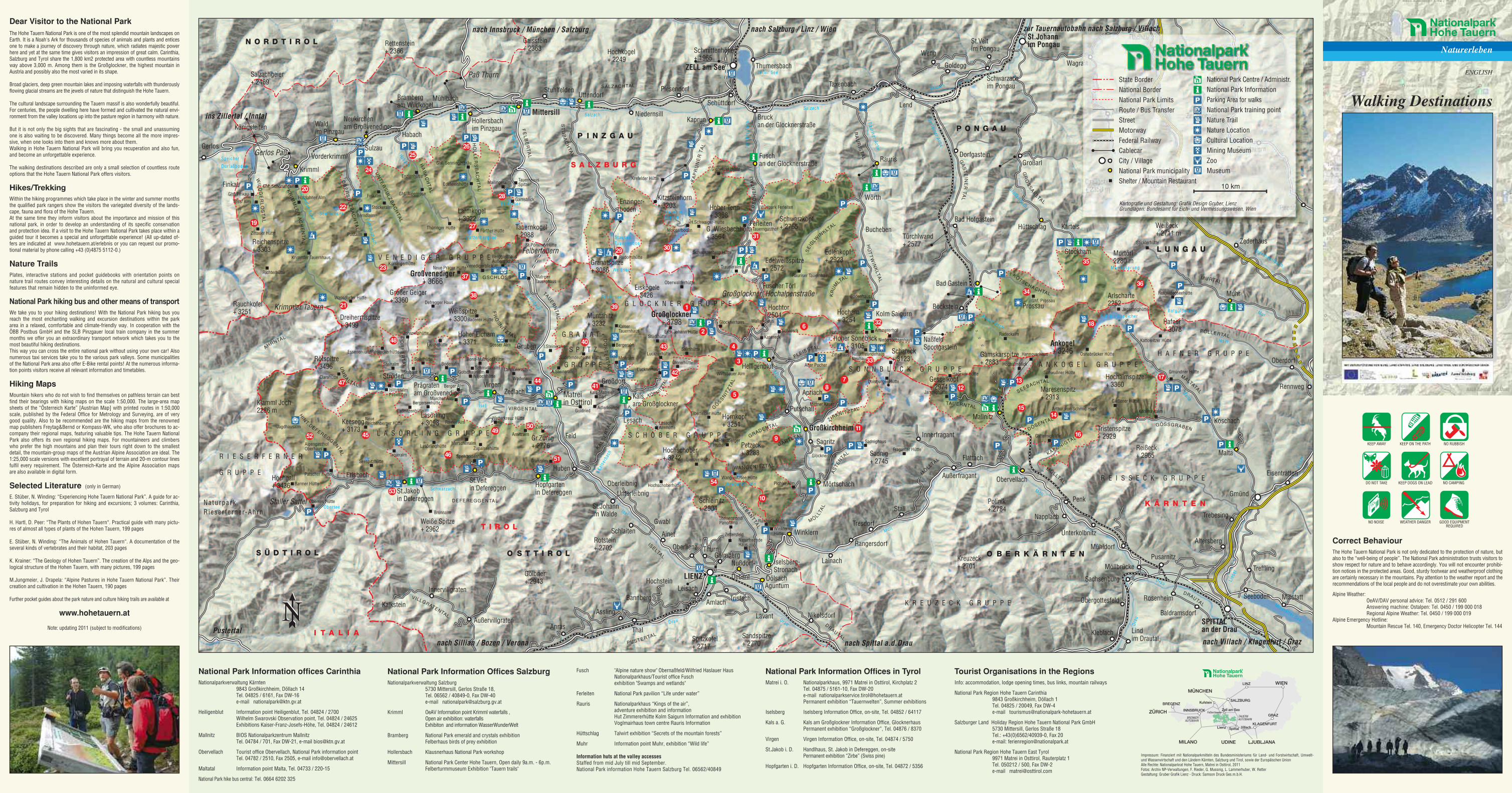
Dear Visitor to the National ParkThe Hohe Tauern National Park is one of the most splendid mountain landscapes onEarth. It is a Noah's Ark for thousands of species of animals and plants and enticesone to make a journey of discovery through nature, which radiates majestic powerhere and yet at the same time gives visitors an impression of great calm. Carinthia,Salzburg and Tyrol share the 1,800 km2 protected area with countless mountainsway above 3,000 m. Among them is the Großglockner, the highest mountain inAustria and possibly also the most varied in its shape.
Broad glaciers, deep green mountain lakes and imposing waterfalls with thunderouslyflowing glacial streams are the jewels of nature that distinguish the Hohe Tauern.
The cultural landscape surrounding the Tauern massif is also wonderfully beautiful.For centuries, the people dwelling here have formed and cultivated the natural envi-ronment from the valley locations up into the pasture region in harmony with nature.
But it is not only the big sights that are fascinating - the small and unassumingone is also waiting to be discovered. Many things become all the more impres-sive, when one looks into them and knows more about them.Walking in Hohe Tauern National Park will bring you recuperation and also fun,and become an unforgettable experience.
The walking destinations described are only a small selection of countless routeoptions that the Hohe Tauern National Park offers visitors.
Hikes/TrekkingWithin the hiking programmes which take place in the winter and summer monthsthe qualified park rangers show the visitors the variegated diversity of the lands-cape, fauna and flora of the Hohe Tauern.At the same time they inform visitors about the importance and mission of thisnational park, in order to develop an understanding of its specific conservationand protection idea. If a visit to the Hohe Tauern National Park takes place within aguided tour it becomes a special and unforgettable experience! (All up-dated of-fers are indicated at www.hohetauern.at/erlebnis or you can request our promo-tional material by phone calling +43 (0)4875 5112-0.)
Nature TrailsPlates, interactive stations and pocket guidebooks with orientation points onnature trail routes convey interesting details on the natural and cultural specialfeatures that remain hidden to the uninformed eye.
National Park hiking bus and other means of transportWe take you to your hiking destinations! With the National Park hiking bus youreach the most enchanting walking and excursion destinations within the parkarea in a relaxed, comfortable and climate-friendly way. In cooperation with theÖBB Postbus GmbH and the SLB Pinzgauer local train company in the summermonths we offer you an extraordinary transport network which takes you to themost beautiful hiking destinations.This way you can cross the entire national park without using your own car! Alsonumerous taxi services take you to the various park valleys. Some municipalitiesof the National Park area also offer E-Bike rental points! At the numerous informa-tion points visitors receive all relevant information and timetables.
Hiking MapsMountain hikers who do not wish to find themselves on pathless terrain can bestfind their bearings with hiking maps on the scale 1:50,000. The large-area mapsheets of the “Österreich Karte” [Austrian Map] with printed routes in 1:50,000scale, published by the Federal Office for Metrology and Surveying, are of verygood quality. Also to be recommended are the hiking maps from the renownedmap publishers Freytag&Bernd or Kompass-WK, who also offer brochures to ac-company their regional maps, featuring valuable tips. The Hohe Tauern NationalPark also offers its own regional hiking maps. For mountaineers and climberswho prefer the high mountains and plan their tours right down to the smallestdetail, the mountain-group maps of the Austrian Alpine Association are ideal. The1:25,000 scale versions with excellent portrayal of terrain and 20-m contour linesfulfil every requirement. The Österreich-Karte and the Alpine Association mapsare also available in digital form.
Selected Literature (only in German)
E. Stüber, N. Winding: “Experiencing Hohe Tauern National Park”. A guide for ac-tivity holidays, for preparation for hiking and excursions; 3 volumes: Carinthia,Salzburg and Tyrol
H. Hartl, D. Peer: “The Plants of Hohen Tauern“. Practical guide with many pictu-res of almost all types of plants of the Hohen Tauern, 199 pages
E. Stüber, N. Winding: “The Animals of Hohen Tauern“. A documentation of theseveral kinds of vertebrates and their habitat, 203 pages
K. Krainer: “The Geology of Hohen Tauern”. The creation of the Alps and the geo-logical structure of the Hohen Tauern, with many pictures, 199 pages
M.Jungmeier, J. Drapela: “Alpine Pastures in Hohe Tauern National Park”. Theircreation and cultivation in the Hohen Tauern, 190 pages
Further pocket guides about the park nature and culture hiking trails are available at
www.hohetauern.at
Note: updating 2011 (subject to modifications)
Gerlos Paß
Krimmler Tauern
Felbertauern
Staller Sattel
Paß Thurn
Großglockner Hochalpenstraße
St.Johannim Pongau
ZELL am See
LIENZ
SPITTALan der Drau
Großkirchheim
P O N G A U
L U N G A U
N O R D T I R O L
S A L Z B U R G
P I N Z G A U
T I R O L
O B E R K Ä R N T E NO S T T I R O LS Ü D T I R O L
K Ä R N T E N
I T A L I A
zur Tauernautobahn nach Salzburg / Villachnach Innsbruck / München / Salzburg nach Salzburg / Linz / Wien
ins Zillertal / Inntal
Pustertal
nach Sillian / Bozen / Verona nach Villach / Klagenfurt / Graznach Spittal a.d.Drau
Mallnitz
Prossau
Bad Gastein
Bad Hofgastein
Aguntum
Mittersill
Karteis
Assling
Prägratenam Großvenediger
Dölsach
Iselsberg-Stronach
Putschall
Rangersdorf
Flachau
Ferleiten
NaßfeldSportgastein
Stockham
Böckstein
Heiligenblut
Millstatt
Eisentratten
Tweng
Lindim Drautal
Rennweg
Rauris
Nußdorf-
Debant
Gaimberg
Winklern
Fuschan der Glocknerstraße
Mörtschach
Bruckan der Glocknerstraße
Taxenbach
Wörth
Bucheben
NikolsdorfLavant
Tristach
Sagritz
Apriach
Tresdorf
Lainach
Thumersbach
Hüttschlag
Muhr
Malta
DorfgasteinGroßarl
Kleinarl
Wagrain
Schwarzachim Pongau
St.Veitim Pongau
Weng
Goldegg
Zauchensee
Obertauern
Flattach
Stall
Außerfragant
Innerfragant
Napplach
Obervellach
Penk
Möllbrücke
Mühldorf
Unterkolbnitz
Gmünd
Pusarnitz
Altersberg
Trebesing
Seeboden
Oberdorf
Zederhaus
Obergottesfeld
Kleblach
Treffling
Lend
Koschach
Rosenheim
Baldramsdorf
Sachsenburg
Zettersfeld
Thurn
Schüttdorf
Amlach
Großdorf
Waldim Pinzgau
Finkau
Königsleiten
SulzauGerlos
Habach
Kalkstein
Oberlienz
Kalsam Großglockner
St.Jakobin Defereggen
Vorderkrimml
Kaprun
Krimml
Brambergam Wildkogel
Hollersbachim Pinzgau
Uttendorf
Virgen
Hopfgartenin Defereggen
St.Veitin Defereggen
MühlbachStuhlfelden
Niedernsill
Piesendorf
Zedlach
ErlsbachHuben
St.Johannim Walde
Lesach
OberleibnigUnterleibnig
Schlaiten Ainet
LeisachBannberg
ThalAnrasAußervillgraten
Innervillgraten
Gruben
Feld
Gwabl
Hochstein
Ströden
Wangenitz See
Dorfersee
Obersee
Kratzenbergsee
Lies
er
Isel
StauseenKaprunO
bersulzbach
Hintersee
Seebachsee
Weißsee
StauseeTauernmoos
Fusc
her
Ach
e
Tauernbach
Drau
Isel
Schwarzach
Kals
erba
ch
Salzach
Felberbach
Habach
Krimm
lerAche
Speicher
Durlaßboden
Mur
Lieser
Großarlbach
KölnbreinspeicherAnlauf Bach
Dra
u
Zel ler See
Rauriser
Ache
Drau
Möl
l
Möll
Salzach
Drau
Millstätter See
Möll
Möll
GasteinerAche
Zederhauslbach
Malta
Salzach
Rotgüldensee
Mur Ursprung
Lies
er
Brunnalm
Matreiin Osttirol
Neukirchenam Großvenediger
Enzinger-boden
Großvenediger+ 3666
Großglockner+ 3798
Ankogel+ 3246
KR
UM
LTAL
SE
IDLW
INKLTAL
KAPONIGTAL
AS
TE
NTA
L
GRADENTALDÖSENTALZIRKNITZTALG
ÖS
SN
ITZ
TAL
TAUE
RN
TAL
KÖDNITZT
AL
KALS
ER
TA
L
MALTATAL
MÖLLTAL
PÖLLERTAL
SEEBACHTAL
GÖSSGRABEN
KÖTSCHACHTAL
GR
OS
SA
RLTAL
MURTAL
WANGENITZTAL
TAUERNTAL
FU
SC
HE
RT
AL
GA
ST
EIN
ER
TA
L
RA
UR
IST
AL
DRAUTAL
MÖ
LLTAL
MÖLLTA
L
DRAUTAL
HÜ
TT
WIN
KLT
AL
WIL
DG
ER
LO
ST
AL
OB
ER
SU
LZ
BA
CH
TA
L
AHRNTAL
FE
LB
ER
TA
L
UN
TE
RS
UL
ZB
AC
HTA
L
HO
LL
ER
SB
AC
HT
AL
ST
UB
AC
HTA
L
DEFEREGGENTAL
HA
BA
CH
TA
LKR
IMM
LE
RA
CH
EN
TA
L
KA
PR
UN
ER
TAL
VIRGENTAL
PUSTERTAL
ISELTAL
SALZACHTAL
VILLGRATENTAL
UM
BA
LTA L
HIN
T.DEFEREGGENTA
L
FR
OS
NITZTA L
GSCHLÖSS
DO
RF
ER
TA
L
DE
BA
NTTA
L
DO
RF
ER
TA
L
FLEISSTAL
GARTLTAL
Gesselkopf+ 2974
Dreiherrnspitze+ 3499
S O N N B L I C K G R U P P E
Gamskarspitze+ 2883
Keesegg+ 3173
Hoher Sonnblick+ 3105
Tristenspitze+ 2929
Maresenspitz+ 2913
Klamml Joch2286 m
Schmittenhöhe+ 1965
Gaisstein+ 2363
L A S Ö R L I N G G R U P P E
A N K O G E L G R U P P E
G R A N A T -
S P I T Z
G R U P P E
Salzachgeier+ 2469
S C H O B E R G R U P P E
Larmkogel+ 3022
Kolm Saigurn
R I E S E R F E R N E R
G R U P P E
NaturparkR ieser fe rner-Ahrn
Granatspitze+ 3086
Reißeck+ 2965
Gr.Zunig+ 2776
Hocharn+ 3254
Edelweißspitze+ 2572
Türchlwand+ 2577
Kitzsteinhorn+ 3203
Sadnig+ 2745
Schareck+ 3123
Hoher Tenn+ 3368
Hochschober+ 3242
Großer Geiger+ 3360
Rötspitze+ 3496
Reichenspitze+ 3303
G. Wiesbachhorn+ 3564
Petzeck+ 3283
Kreuzeck+ 2701
Spitzkofel+ 2717
Hochalmspitze+ 3360
Draugstein+ 2358 m
Hoher Eicham+ 3371
Hochgall+ 3436
Rauchkofel+ 3251
Tauernkogel+ 2988
Hochtor2504
Hafner+ 3078
Arlscharte2252
Mosermandl+ 2680 m
Weißeck+ 2711 m
Murtörl2280 m
G L O C K N E R G R U P P E
V E N E D I G E R G R U P P E
K R E U Z E C K G R U P P E
Gölbner+ 2943
Edlenkopf+ 2923
Schleinitz+ 2904
Hornkopf+ 3251
Rotstein+ 2702
Weiße Spitze+ 2962
Rettenstein+ 2366 Hochkogel
+ 2249
Eiskögele+ 3426
Fuscher Törl
Schwarzkopf+ 2765
Polinik+ 2784
Sandspitze+ 2770
Lasörling+ 3098
Muntanitz+ 3232
Weißspitze+ 3300
H A F N E R G R U P P E
R E I S S E C K G R U P P E
1
10
11
1213
1415
18
19
2028
27
2625
24
23
22
29 30
31
32
33
34
35
3637
38
39
40
41
42
43
45
46
47
53
54
52
51
5049
48
2
21
5
4
3
16
17
6
9
78
44
Rudolfshütte
H.Schwaiger-Hütte
KalserTauernhaus
Essener- undRostockerhütte
Badener Hütte
Defregger Haus
Bonn-Matreier Hütte
AlpengasthofOberhaus
Jagdhausalm
Clarahütte
Lasörlinghütte
Arnitzalm
Wetterkreuz Hütte
Zunigalm
Kals-Matreier Törl
Sudetendeutsche Hütte
Stüdlhütte
Salmhütte
Glorerhütte
Lucknerhütte
Lienzer Hütte
Wangenitzsee Hütte
Ad.-NoßbergerHütte
Oberwalderhütte
Rauriser Tauernhaus
St.Pöltener Hütte
Eisseehütte
Thüringer Hütte
KürsingerhütteKrimmler Tauernhaus
Richterhütte
Zittauer Hütte
Wansdorfer Hütte
Krefelder Hütte
Fürther Hütte
Gleiwitzer Hütte
Fraganter Hütte
Osnabrücker Hütte
Kohlmayralm
Kattowitzer Hütte
Patscher Hütte
Obersee Hütte
Johannishütte
Neue Prager HütteVenedigerblick
Gosser Alm
Sajathütte
Niljochhütte Wodenalm
IslitzeralmPebellalm
Elberfelder Hütte
LesachAlmhütte
Hochschoberhütte
Wirtsbauer Alm
Glocknerhaus
Erzh.Johann Hütte
Glanzalm
Zupalseehütte
Bergerseehütte
Laßnitzenhütte
NeueReichenberger Hütte
TrojeralmSeespitzhütte
Speikbodenhütte
A.Steineralm
MatreierTauernhaus
Bergeralm
Lucknerhaus
NaturfreundeHaus
Raneralmhütte
WinklernerHütte
Sadnighaus
Zittelhaus
Hagener Hütte
Hannoverhaus
Gießener Hütte
Arthur von Schmid Haus
Gmündner Hütte
Pichler Alm
Schwußner Hütte
Hochalmblick
Jamnighütte
Steinalm
Stabant H.
Ghf. Finkau
Trissl Alm
Ghf. Schönangerl
Postalm
Hölzlahner Alm
Berndlalm
Finkalm
Stockeralm
Enzianhütte
Ghf. Alpenrose
Ghf. Senningerbräu
Edelweishütte
Gamsblick
TauernhausSpitalMailingeralm
Mooserboden
Schwarzenberg Hütte
Trauneralm
Tauerngasthof
Bodenhaus
NaturfreundehausNeubau
Ammererhof
Niedersachsenhaus
Duisburger Hütte
Radeckalm
Ghf. Prossau
Sticklerhütte
Rotgüldenseehütte
Alter Pocher
Glocknerblick
Wallackhaus
KasereckSchareck Naturfreundehaus
Wildpark Ferleiten
Barmer Hütte
BerggasthausAußergschlöss
Bodenalm
Rainer Alm
Marcher Alm
Berger Alm
Merschenalm
Gotschaunalm Lanthaleralm
I.Steineralm
Adlerlounge
SteinermandlPanorama
Gatternighütte
Moaralm
Schmidleralm
GoldriedMittner Kaser
Jagasteighütte
Naturerleben
Walking Destinations
ENGLISH
KEEP AWAY KEEP ON THE PATH NO RUBBISH
DO NOT TAKE KEEP DOGS ON LEAD NO CAMPING
NO NOISE WEATHER DANGER GOOD EQUIPMENTREQUIRED
Correct BehaviourThe Hohe Tauern National Park is not only dedicated to the protection of nature, butalso to the “well-being of people”. The National Park administration trusts visitors toshow respect for nature and to behave accordingly. You will not encounter prohibi-tion notices in the protected areas. Good, sturdy footwear and weatherproof clothingare certainly necessary in the mountains. Pay attention to the weather report and therecommendations of the local people and do not overestimate your own abilities.
Alpine Weather:OeAV/DAV personal advice: Tel. 0512 / 291 600Answering machine: Ostalpen: Tel. 0450 / 199 000 018Regional Alpine Weather: Tel. 0450 / 199 000 019
Alpine Emergency Hotline:Mountain Rescue Tel. 140, Emergency Doctor Helicopter Tel. 144
National Park Information offices CarinthiaNationalparkverwaltung Kärnten
9843 Großkirchheim, Döllach 14Tel. 04825 / 6161, Fax DW-16e-mail [email protected]
Heiligenblut Information point Heiligenblut, Tel. 04824 / 2700Wilhelm Swarovski Observation point, Tel. 04824 / 24625Exhibitions Kaiser-Franz-Josefs-Höhe, Tel. 04824 / 24612
Mallnitz BIOS Nationalparkzentrum MallnitzTel. 04784 / 701, Fax DW-21, e-mail [email protected]
Obervellach Tourist office Obervellach, National Park information pointTel. 04782 / 2510, Fax 2505, e-mail [email protected]
Maltatal Information point Malta, Tel. 04733 / 220-15
National Park hike bus central: Tel. 0664 6202 325
Impressum: Finanziert mit Nationalparkmitteln des Bundesministeriums für Land- und Forstwirtschaft, Umwelt-und Wasserwirtschaft und den Ländern Kärnten, Salzburg und Tirol, sowie der Europäischen UnionAlle Rechte: Nationalparkrat Hohe Tauern, Matrei in Osttirol, 2011Fotos: Archiv NP-Verwaltungen, F. Rieder, G. Mussnig, L. Lammerhuber, W. RetterGestaltung: Gruber Grafik Lienz - Druck: Samson Druck Ges.m.b.H.
National Park Information Offices SalzburgNationalparkverwaltung Salzburg
5730 Mittersill, Gerlos Straße 18,Tel. 06562 / 40849-0, Fax DW-40e-mail [email protected]
Krimml OeAV Information point Krimml waterfalls ,Open air exhibition: waterfallsExhibiton and information WasserWunderWelt
Bramberg National Park emerald and crystals exhibitionFelberhaus birds of prey exhibition
Hollersbach Klausnerhaus National Park workshop
Mittersill National Park Center Hohe Tauern, Open daily 9a.m. - 6p.m.Felberturmmuseum Exhibition "Tauern trails"
Fusch "Alpine nature show" Obernaßfeld/Wilfried Haslauer HausNationalparkhaus/Tourist office Fuschexhibition "Swamps and wetlands"
Ferleiten National Park pavilion “Life under water”
Rauris Nationalparkhaus “Kings of the air”,adventure exhibition and informationHut Zimmererhütte Kolm Saigurn Information and exhibitionVoglmairhaus town centre Rauris Information
Hüttschlag Talwirt exhibition “Secrets of the mountain forests”
Muhr Information point Muhr, exhibition “Wild life”
Information huts at the valley accessesStaffed from mid July till mid September.National Park information Hohe Tauern Salzburg Tel. 06562/40849
National Park Information Offices in TyrolMatrei i. O. Nationalparkhaus, 9971 Matrei in Osttirol, Kirchplatz 2
Tel. 04875 / 5161-10, Fax DW-20e-mail [email protected] exhibition “Tauernwelten”, Summer exhibitions
Iselsberg Iselsberg Information Office, on-site, Tel. 04852 / 64117
Kals a. G. Kals am Großglockner Information Office, GlocknerhausPermanent exhibition “Großglockner”, Tel. 04876 / 8370
Virgen Virgen Information Office, on-site, Tel. 04874 / 5750
St.Jakob i. D. Handlhaus, St. Jakob in Defereggen, on-sitePermanent exhibition “Zirbe” (Swiss pine)
Hopfgarten i. D. Hopfgarten Information Office, on-site, Tel. 04872 / 5356
Tourist Organisations in the RegionsInfo: accommodation, lodge opening times, bus links, mountain railways
National Park Region Hohe Tauern Carinthia9843 Großkirchheim, Döllach 1Tel. 04825 / 20049, Fax DW-4e-mail [email protected]
Salzburger Land Holiday Region Hohe Tauern National Park GmbH5730 Mittersill, Gerlos Straße 18Tel.: +43(0)6562/40939-0, Fax 20e-mail: [email protected]
National Park Region Hohe Tauern East Tyrol9971 Matrei in Osttirol, Rauterplatz 1Tel. 050212 / 500, Fax DW-2e-mail [email protected]
Kartografie und Gestaltung: Grafik Design Gruber, LienzGrundlagen: Bundesamt für Eich- und Vermessungswesen, Wien
10 km
National Park Centre / Administr.National Park InformationParking Area for walksNational Park training pointNature TrailNature LocationCultural LocationMining MuseumZooMuseum
State BorderNational BorderNational Park LimitsRoute / Bus TransferStreetMotorwayFederal RailwayCablecarCity / VillageNational Park municipalityShelter / Mountain Restaurant


