H.M. Government of Gibraltar · H.M. Government of Gibraltar Marine Strategy Framework Directive...
83
H.M. Government of Gibraltar Marine Strategy Framework Directive Initial Assessment and Proposals for Good Environmental Status in British Gibraltar Territorial Waters December 2012 Produced in collaboration with AMEC Environment & Infrastructure UK Limited.
Transcript of H.M. Government of Gibraltar · H.M. Government of Gibraltar Marine Strategy Framework Directive...

H.M. Government of Gibraltar
Marine Strategy Framework Directive
Initial Assessment and Proposals for Good Environmental
Status in British Gibraltar Territorial Waters
December 2012
Produced in collaboration with AMEC Environment & Infrastructure UK Limited.

Report for
Stephen Warr
Department of the Environment
Duke of Kent House
Line Wall Road
Gibraltar
Main Contributors
Alexia Chapman
Ben King
Kathy Stevenson
Front cover photo credits (left to right):
Serranus Cabrilla in Seven Sisters Reef: Dr. Darren Fa
Shoal of Boops boops over Europa Reef: Clive Crisp
Felimare picta on SS Rosyln (artificial reef): Dr. Darren Fa
H.M. Government of Gibraltar
Initial Assessment and
Proposals for Good
Environmental Status in British
Gibraltar Territorial Waters
December 2012
Produced in conjunction with AMEC
Environment & Infrastructure
UK Limited.
In accordance with an environmentally responsible approach,
this document is printed on recycled paper produced from 100%
post-consumer waste, or on ECF (elemental chlorine free) paper

1
© HM Government of Gibraltar December 2012
Contents
1. Introduction 4
1.1 Introduction 4
1.2 Background to the Marine Strategy Framework Directive
(MSFD) 5
1.3 The European and Regional Context 7
1.4 Role of existing policies in supporting the achievement of
GES 9
2. Initial Assessment of British Gibraltar Territorial
Waters 13
2.1 Introduction 13
2.2 The Evidence Base 13
2.3 Regional coordination with EU member states 14
2.4 Analysis of the economic and social use of Gibraltar seas
and the predominant pressures 15
3. Current and Predicted Status of British Gibraltar
Territorial Waters 21
3.1 Introduction 21
3.2 Habitat types (Descriptors 1, 4 and 6) 21
3.3 Biological features (Descriptors 1, 4 and 6) 28
3.4 Non-indigenous species (Descriptor 2) 40
3.5 Commercial fish stocks (Descriptor 3) 42
3.6 Eutrophication (Descriptor 5) 45
3.7 Hydrographic conditions (Descriptor 7) 48
3.8 Contaminants (Descriptors 8 and 9) 43
3.9 Litter (Descriptor 10) 61
3.10 Underwater noise (Descriptor 11) 63
4. Proposals for GES characteristics and targets and
indicators 66
4.1 Introduction 66
4.2 Biodiversity (Descriptors 1, 4 and 6) 66

2
© HM Government of Gibraltar December 2012
4.3 Non-indigenous species (Descriptor 2) 72
4.4 Eutrophication (Descriptor 5) 74
4.5 Hydrographic conditions (Descriptor 7) 75
4.6 Concentration of contaminants (Descriptor 8) 76
4.7 Contaminants in fish and other species (Descriptor 9) 78
4.8 Litter (Descriptor 10) 79
4.9 Underwater noise (Descriptor 11) 80
Table 1.1 MSFD Marine regions and associated sub-regions Table 2.1 Financial costs (operating and capital costs) of AquaGib in 2009/2010 Table 2.2 Estimated annual costs of carbon (2010 prices) for seawater desalination Table 2.3 Pressures within the coastal environment Table 2.4 Pressures within the coastal environment. Table 3.1 Main fish species found over or on sandy benthic habitat. Source: BAP, Gibraltar. Table 3.2 Main pelagic fish found in the Strait of Gibraltar. Source: BAP, Gibraltar. Table 3.3 Main cetacean species seen in British Gibraltar Territorial Waters
Figure 1.1 Key stages in the MSFD implementation Figure 1.2 Area of British Gibraltar Territorial waters where the MSFD applies Figure 2.1 No anchoring zones in British Gibraltar Territorial Waters Figure 3.1 Spatial distribution of reefs in British Gibraltar Territorial waters Figure 3.3 Distribution of submerged or partially submerged caves
Figure 3.4. Location of MCZs in British Gibraltar Territorial Waters Figure 3.4 Main current flows in the Bay of Gibraltar during (a) tidal flux and (b) tidal reflux.

3
© HM Government of Gibraltar December 2012
Glossary
ACCOBAMS Agreement on the Conservation of Cetaceans Of the Black And Mediterranean Seas.
BGTW British Gibraltar Territorial Waters
BOPA Benthic Opportunistic Polychaetes and Amphipod – a biotic index
CBD Convention on Biological Diversity
CO2 Carbon Dioxide
DBT Dibutyltin
dB re 1µPa Decibel relative to 1 micro Pascal - measure of sound pressure level. oC Degrees Centigrade
DIN Dissolved Inorganic Nitrogen
EAC Ecologically Acceptable Concentration
EC European Commission
EEC European Economic Community
EIA Environmental Impact Assessment
EQS Ecological Quality Standards
EU European Union
GES Good Environmental Status
GHG Green House Gas
GONHS Gibraltar Ornithological & Natural History Society
HWMB Heavily Modified Water Body
Hz Hertz
IAS Invasive Alien Species
kg Kilograms
kHz Kilohertz
km Kilometre
m Meter
MAP Mediterranean Action Plan
MCZ Marine Conservation Zone
ml Millilitre
MoD Ministry of Defence
MPA Marine Protected Area
MSFD Marine Strategy Framework Directive
NPA Nature Protection Act
NGO Non-Governmental Organisation
NIS Non-Indigenous Species
nm Nautical Mile
ppt Parts Per Thousand
REACH Registration, Evaluation, Authorisation and Restriction of Chemical substances
SAC Special Area Conservation
SPA Special Protection Areas
t Tonnes
TBT Tributyltin
UK United Kingdom
UNEP United Nations Environment Plan
WFD Water Framework Directive

4
© HM Government of Gibraltar December 2012
1. Introduction
1.1 Introduction
1.1.1 Within Europe marine habitats and species continue to be affected by human activities. The Marine Strategy
Framework Directive (MSFD) (2008/56/EC) was developed in response to concerns that although existing legislation
protected the sea from some specific impacts, it was sectoral and fragmented. There was also recognition that since some
of the activities that impact on the marine environment are managed at a European or international level (e.g. fisheries
and shipping) and other impacts can cross national boundaries (e.g. litter, eutrophication, noise), national action to
protect the marine environment needs to be supported by a framework to ensure action is taken across Europe.
1.1.2 The MSFD requires Member States to put in place the necessary management measures to achieve Good
Environmental Status (GES) in their marine waters by 2020. GES is defined in the Directive1
and described in more
detail by 11 high-level Descriptors (see p.8) which set out what Member States must achieve in their marine waters.
Achieving GES involves protecting the marine environment, preventing its deterioration and restoring it where practical,
whilst at the same time providing for sustainable use of marine resources.
1.1.3 The MSFD requires Member States to go through a number of stages before the eventual implementation of
management measures to achieve GES (see Figure 1.1, below). The first stage, to be completed by July 2012, was for
Member States to carry out an initial assessment of the current status of their seas and to determine specific
characteristics of GES for their marine waters, setting out specific environmental targets and indicators to underpin this
(based on the 11 Descriptors of GES given in the Directive). The second stage, to be completed by 2014, is for Member
States to put in place monitoring programmes to measure progress towards GES. The final stage is the implementation of
management measures to achieve GES by 2020. These have to be developed by 2015 and implemented by 2016. Each
stage of the implementation process then has to be reviewed every 6 years and if necessary updated.
Figure 1.1 Key stages in the MSFD implementation
1 MSFD, 2008/56/EC Article 3(5) – Good Environmental Status means the environmental status of marine waters where these provide ecologically
diverse and dynamic oceans and seas which are clean, healthy and productive within their intrinsic conditions, and the use of the marine environment is
at a level that is sustainable, thus safeguarding the potential for uses and activities by current and future generations. A fuller description is set out at
MSFD, 2008/56/EC Article 3(5).

5
© HM Government of Gibraltar December 2012
1.1.4 The Government of Gibraltar has already committed to taking numerous measures which have and will continue to
improve the state of Gibraltar’s marine environment as part of ensuring sustainable development, most notably through
the Nature Protection Act (NPA) 1991, Public Health (Water Framework Rules) 2004, Public Health (Pollution of the
Aquatic Environment) Rules 1994, Environment (Quality of Bathing Water Regulations (2009) Marine Strategy
Regulations 2011 and the Marine Protection Regulations . Equally, other existing pieces of EU legislation, such as the
Birds and Habitats Directives that have been transposed into the NPA 1991, also contribute to improving the state of
Gibraltar’s marine and coastal environments. These existing measures will all support the achievement of GES under the
MSFD.
1.1.5 This report sets out the Government of Gibraltar’s proposals for the first stage of the MSFD implementation
process. The proposals cover the following:
• The initial assessment of the current state of British Gibraltar Territorial Waters (BGTW) as required under
Article 8 of the MSFD. The Initial Assessment is based primarily on evidence from the River Basin
Management Plan, as well as other various reports such as those under the Habitats Directive, Bathing
Waters Directive, and monitoring evidence.
• Proposals for Gibraltar characteristics of GES (as required under Article 9 of the MSFD).
• Proposals for more detailed UK targets and indicators of GES (as required under Article 10 of the MSFD).
1.2 Background to the Marine Strategy Framework Directive (MSFD)
1.2.1 The MSFD establishes a framework within which Member States shall take the necessary measures to achieve or
maintain GES in the marine environment by 2020 at the latest. The aims of the Directive are to:
• ‘Protect and preserve the marine environment, prevent its deterioration or, where practicable, restore
marine ecosystems in areas where they have been adversely affected’; and
• ‘Prevent and reduce inputs in the marine environment, with a view to phasing out pollution, so as to ensure
that there are no significant impacts on or risks to marine biodiversity, marine ecosystems, human health or
legitimate uses of the sea.’2
1.2.2 Member States must apply an ecosystem-based approach to the management of human activities. In this context
this means ensuring that the collective pressure of human activities is kept within the levels compatible with the
achievement of GES, ensuring that the capacity of the marine ecosystem to respond to human-induced changes is not
compromised, whilst enabling the sustainable use of the marine environment now and in the future3.
1.2.3 The aims of the Directive are to be delivered through the development of marine strategies covering the following
elements:
(a) An Initial Assessment of marine waters analysing the essential features, characteristics and environmental
status of those waters (by July 2012, with subsequent assessments carried out on a six-yearly basis);
(b) Determination of a set of characteristics for GES, based on the 11 GES Descriptors set out below (by July
2012, reviewed on a six-yearly basis);
(c) Establishment of comprehensive environmental targets and indicators to guide progress towards achieving
GES (by July 2012, reviewed on a six-yearly basis);
(d) Establishment and implementation of a coordinated monitoring programme for the ongoing assessment of
GES (by July 2014, reviewed on a six-yearly basis);
2 MSFD 2008/56/EC Article 1(2)
3 MSFD 2008/56/EC Article 1(3)

6
© HM Government of Gibraltar December 2012
(e) Development of a programme of measures designed to achieve GES by 2020 (by Dec 2015, reviewed and
revised on a six-yearly basis); and
(f) Implementation of the programme of measures described above (by Dec 2016, reviewed on a six-yearly
basis).
1.2.4 Each stage of the marine strategy must be reviewed every six years and revised if necessary4. As explained in the
introduction, this paper covers Gibraltar’s proposals for the first three elements of the marine strategy – (a), (b) and (c)
above.
1.2.5 GES is defined in the Directive as follows: ‘Good Environmental Status means the environmental status of marine
waters where these provide ecologically diverse and dynamic oceans and seas which are clean, healthy and productive
within their intrinsic conditions, and the use of the marine environment is at a level that is sustainable, thus safeguarding
the potential for uses and activities by current and future generations’5.
1.2.6 GES is also described in more detail by 11 high-level Descriptors of GES which Member States must use as the
basis for their GES targets and indicators6. The 11 GES Descriptors are set out in Box 1.1 below.
Box 1.1 Qualitative descriptors for determining GES
Descriptor 1 (D1): Biological diversity is maintained. The quality and occurrence of habitats and the distribution and abundance of species are in line with prevailing physiographic, geographic and climatic conditions.
Descriptor 2 (D2): Non-indigenous species introduced by human activities are at levels that do not adversely alter the ecosystems.
Descriptor 3 (D3): Populations of all commercially exploited fish and shellfish are within safe biological limits, exhibiting a population age and size distribution that is indicative of a healthy stock.
Descriptor 4 (D4): All elements of the marine food webs, to the extent that they are known, occur at normal abundance and diversity and levels capable of ensuring the long-term abundance of the species and the retention of their full reproductive capacity.
Descriptor 5 (D5): Human-induced eutrophication is minimised, especially adverse effects thereof, such as losses in biodiversity, ecosystem degradation, harmful algae blooms and oxygen deficiency in bottom waters.
Descriptor 6 (D6): Sea floor integrity is at a level that ensures that the structure and functions of the ecosystems are safeguarded and benthic ecosystems, in particular, are not adversely affected.
Descriptor 7 (D7): Permanent alteration of hydrographical conditions does not adversely affect marine ecosystems.
Descriptor 8 (D8): Concentrations of contaminants are at levels not giving rise to pollution effects.
Descriptor 9 (D9): Contaminants in fish and other seafood for human consumption do not exceed levels established by Community legislation or other relevant standards.
Descriptor 10 (D10): Properties and quantities of marine litter do not cause harm to the coastal and marine environment.
Descriptor 11 (D11): Introduction of energy, including underwater noise, is at levels that do not adversely affect the marine environment.
4 As required under Article 17(2) of Directive 2008/56/EC
5 MSFD 2008/56/EC Article 3(5) – a fuller definition can be found in this Article
6 MSFD 2008/56/EC Annex 1
7
© HM Government of Gibraltar December 2012
1.2.7 Member States are required to further develop these 11 GES Descriptors by determining a more detailed set of
characteristics for GES7. In turn, these characteristics must be underpinned by the more specific GES targets and
indicators8 which will be used to assess progress towards the achievement of GES.
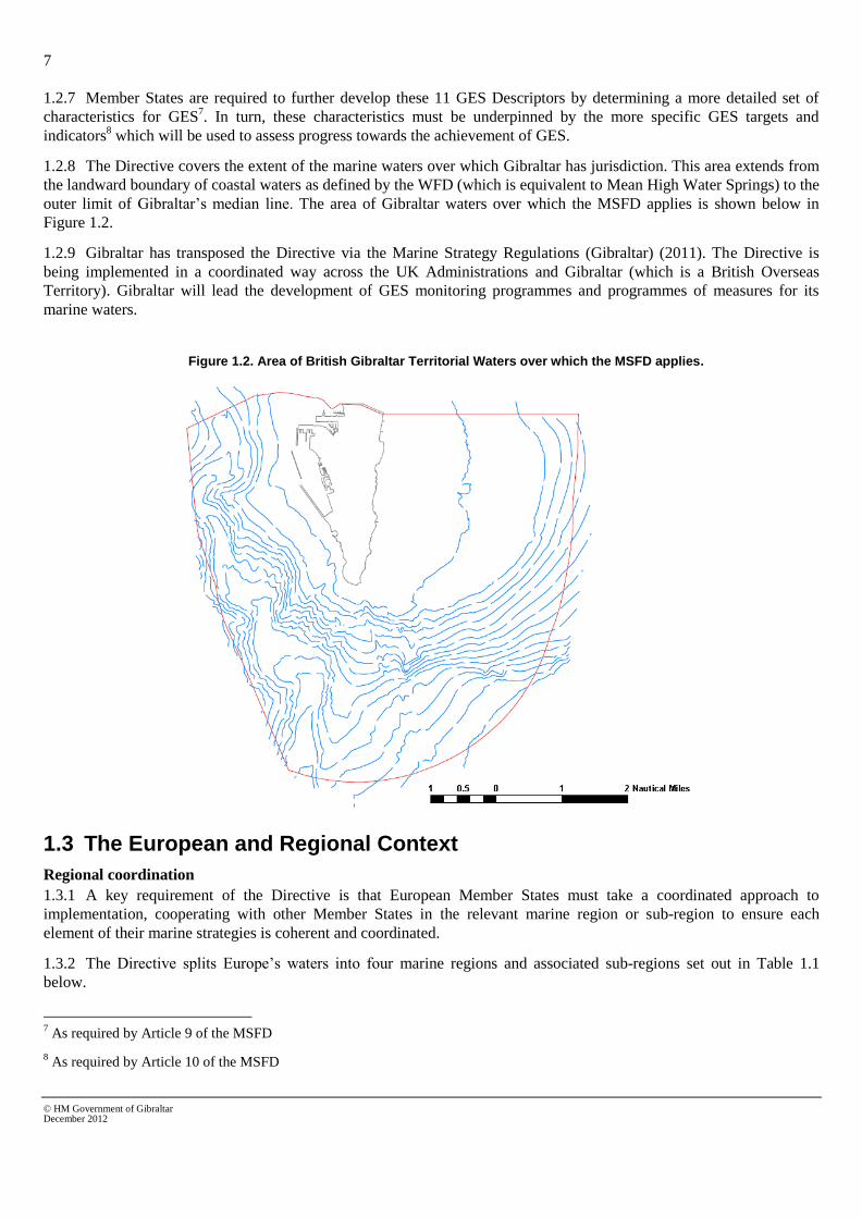
1.2.8 The Directive covers the extent of the marine waters over which Gibraltar has jurisdiction. This area extends from
the landward boundary of coastal waters as defined by the WFD (which is equivalent to Mean High Water Springs) to the
outer limit of Gibraltar’s median line. The area of Gibraltar waters over which the MSFD applies is shown below in
Figure 1.2.
1.2.9 Gibraltar has transposed the Directive via the Marine Strategy Regulations (Gibraltar) (2011). The Directive is
being implemented in a coordinated way across the UK Administrations and Gibraltar (which is a British Overseas
Territory). Gibraltar will lead the development of GES monitoring programmes and programmes of measures for its
marine waters.
Figure 1.2. Area of British Gibraltar Territorial Waters over which the MSFD applies.
1.3 The European and Regional Context
Regional coordination
1.3.1 A key requirement of the Directive is that European Member States must take a coordinated approach to
implementation, cooperating with other Member States in the relevant marine region or sub-region to ensure each
element of their marine strategies is coherent and coordinated.
1.3.2 The Directive splits Europe’s waters into four marine regions and associated sub-regions set out in Table 1.1
below.
7 As required by Article 9 of the MSFD
8 As required by Article 10 of the MSFD

8
© HM Government of Gibraltar December 2012
Table 1.1 MSFD Marine regions and associated sub-regions
Marine regions Relevant sub-regions (if any)
The Baltic Sea No sub-regions specified.
The North East Atlantic Ocean The Greater north Sea, including Kattegat and the English Channel
The Celtic Seas
The Bay of Biscay and the Iberian Coast
The Macronesian biogeographic region (the waters surrounding the Azores, Madeira and the Canary Islands)
The Mediterranean Sea The Western Mediterranean Sea
The Adriatic Sea
The Ionian Sea and the Central Mediterranean Sea
The Aegean-Levantine Sea
The Black Sea No sub-regions specified
1.3.3 BGTW are located in the Mediterranean region and will therefore rely on developments made under the Barcelona
Convention where applicable (see 1.3.9 below).
European level coordination
1.3.4 Coordination between countries is taking place both at a European-wide scale (for generic issues) and within the
specific marine regions set out above (for more detailed issues). At a European level, coordination is being carried out
through a series of informal Working Groups led by the European Commission.
1.3.5 The Working Group on GES – this Working Group has been set up to support Member States in developing
their characteristics of GES and the associated targets and indicators, with the aim of ensuring a comparability of
approaches across the EU. The group has led the development of two key documents:
• The Commission Decision on GES9 - this is a formal document which sets out specific criteria and
indicators for each of the 11 GES Descriptors which Member States must follow when developing their
national GES targets and indicators.
• The Common Understanding of Articles 8, 9 and 1010
- this is an informal document jointly drafted by the
European Commission and the EU Member States Finland, France, Germany, Greece, Romania, Sweden
and the UK. The document provides a common understanding of the development of the initial assessment
and GES characteristics and associated targets and indicators (Articles 8, 9 and 10) to aid Member States in
implementing the requirements of the MSFD in a comparable and consistent way.
1.3.6 This Working Group also has two technical sub-groups, one on litter (Descriptor 10) and one on noise (Descriptor
11) which have a remit to review monitoring methodologies and develop proposals for new monitoring, provide a
platform for sharing best practice on the development of GES characteristics, targets and indicators, and recommend
proposals for further research.
1.3.7 The Working Group on Economic and Social Analysis – this Working Group is co-chaired by the UK and has
been set up to support Member States in meeting the economic and social assessment requirements of the Directive, with
the aim of ensuring comparability of approaches across the EU. It has led the development of an informal guidance
9 Commission Decision of 1 September 2010 on criteria and methodological standards on good environmental status of marine waters
2010/477/EU http://eur-lex.europa.eu/LexUriServ/LexUriServ.do?uri=OJ:L:2010:232:0014:0024:EN:PDF (accessed 11/12/2012)
10 Copies available on request from Defra

9
© HM Government of Gibraltar December 2012
document on Economic and Social Analysis for the Initial Assessment10
which sets out informal guidance for Member
States on possible approaches for this assessment.
1.3.8 The Working Group on Data, Information and Knowledge Exchange – this Working Group has been set up to
develop a coordinated MSFD information and data reporting process. It is in the process of developing proposals for
reporting sheets to capture Member States’ data and information associated with the initial assessment, characteristics of
GES and associated targets and indicators. The Working Group will also concern itself with the development of the data
infrastructures that are needed to facilitate the implementation of the Directive at European and Member State level,
working as far as possible to use existing data initiatives and to remove duplication of reporting with related Directives.
Regional level coordination
1.3.9 Article 6 of the MSFD11
recommends Member States to use existing regional institutional cooperation structures,
such as those under Regional Sea Conventions, in order to achieve coherence and coordination of their marine strategies
and build upon relevant existing programmes and activities. The key forum for regional coordination in the
Mediterranean Sea is the Barcelona Convention, implemented through UNEP’s Mediterranean Action Plan (MAP). The
following recent activities in relation to the MSFD have been carried out at a regional level in line with the Barcelona
Convention:
• The Contracting Parties to the Barcelona Convention developed a set of ecological objectives, operational
objectives, and indicators, which reflect Mediterranean priorities and are coherent with the MSFD. The
ecological objectives were defined through an intensive process of consultation led by the UNEP/MAP
Secretariat.
• The publication of UNEP’s MAP final report for the ‘Support to the Barcelona Convention for the
Implementation of the Ecosystem Approach, Including the Establishment of MPAs in Open Seas Areas,
Including Deep Sea Final Report’12
.
• As a result an adaptive and integrated strategy for the implementation of the Ecosystems Approach in the
Mediterranean will aim to achieve 11 ecological objectives, which are all in line with the MSFD objectives.
• The publication of the following report ‘State of the Mediterranean Marine and Coastal Environment,
Highlights for Policy Makers’ (UNEP 2012) as an overarching regional-scale assessment of the
environmental quality status of the Mediterranean. The work to prepare this report and its underlying
thematic assessment reports provides the primary basis for coordination of national initial assessments
across the region.
1.4 Role of existing policies in supporting the achievement of GES
Water Framework Directive (2000/60/EC)
1.4.1 The Water Framework Directive is designed to create a Europe wide way of measuring and monitoring water
bodies with a specific aim of assessing water quality. Within the Water Framework Directive are the definitions of Good
Ecological Status for both terrestrial and coastal water bodies. Its main aims are to:
• enhance the status and prevent further deterioration of aquatic ecosystems and associated wetlands which
depend on the aquatic ecosystems;
• promote the sustainable use of water;
• reduce pollution of water, especially by ‘priority’ and ‘priority hazardous’ substances; and
11
MSFD 2008/56/EC Article 6(1)
12 The report is available at http://195.97.36.231/dbases/publications/SBCI_ECAP_FinalReport.pdf (accessed 11/12/2012)

10
© HM Government of Gibraltar December 2012
• ensure progressive reduction of groundwater pollution.
1.4.2 The directive outlines an assessment methodology to standardise the way that water body quality is assessed.
Where water bodies have failed Good Ecological Status, the Directive aims to identify the source and manageable goals
with the aim of improving quality. The ultimate aim for the Directive is for water bodies across Europe to be achieving
Good Ecological Status (or higher), or to be improving so that Good Ecological Status will be achieved, where possible,
by 2015. Implementation the Water Framework Directive will enable Descriptors 5, 7, 8 and 9 to be addressed
Habitats Directive (92/43/EEC)
1.4.3 The Council Directive 92/43/EEC on the Conservation of natural habitats and of wild fauna and flora (‘Habitats
Directive’) is a Directive that is designed to maintain and improve natural habitats by protecting ecologically important
species and habitats. Maintaining biodiversity is an important part of maintaining Good Ecological Status.
1.4.4 The provisions of the Directive require Member States to introduce a range of measures, including:
• Maintain or restore European protected habitats and species listed in the Annexes at a favourable
conservation status as defined in Articles 1 and 2;
• Contribute to a coherent European ecological network of protected sites by designating Special Areas of
Conservation (SACs) for habitats listed on Annex I and for species listed on Annex II. These measures are
also to be applied to Special Protection Areas (SPAs) classified under Article 4 of the Birds Directive.
Together SACs and SPAs make up the Natura 2000 network (Article 3);
• Ensure conservation measures are in place to appropriately manage SACs and ensure appropriate
assessment of plans and projects likely to have a significant effect on the integrity of an SAC. Projects may
still be permitted if there are no alternatives, and there are imperative reasons of overriding public interest.
In such cases compensatory measures are necessary to ensure the overall coherence of the Natura 2000
network (Article 6);
• Member States shall also endeavour to encourage the management of features of the landscape that support
the Natura 2000 network (Articles 3 and10);
• Undertake surveillance of habitats and species (Article 11);
• Ensure strict protection of species listed on Annex IV (Article 12 for animals and Article 13 for plants); and
• Report on the implementation of the Directive every six years (Article 17), including assessment of the
conservation status of species and habitats listed on the Annexes to the Directive.
1.4.5 The Habitats Directive aims to look at ecosystems and species and offer protection to important and vulnerable
species, it provide the framework for addressing Descriptors 1, 2,3,4 and 6.
The Birds Directive (2009/147/EC)
1.4.6 The Council Directive 2009/147/EC on the conservation of wild birds (‘Birds Directive’) is designed to maintain
biodiversity and Good Ecological Status through the protection of natural bird wildlife. It is a European wide framework
designed to manage and conserve wild bird populations and the interactions between bird populations and humans.
1.4.7 The main provisions of the Directive include:
• The maintenance of the populations of all wild bird species across their natural range (Article 2) with the
encouragement of various activities to that end (Article 3);
• The identification and classification of Special Protection Areas (SPAs) for rare or vulnerable species listed
in Annex I of the Directive, as well as for all regularly occurring migratory species, paying particular
attention to the protection of wetlands of international importance (Article 4). (Together with Special Areas
of Conservation designated under the Habitats Directive, SPAs form a network of European protected areas
known as Natura 2000);

11
© HM Government of Gibraltar December 2012
• The establishment of a general scheme of protection for all wild birds (Article 5);
• Restrictions on the sale and keeping of wild birds (Article 6);
• Specification of the conditions under which hunting and falconry can be undertaken (Article 7). (Huntable
species are listed on Annex II of the Directive);
• Prohibition of large-scale non-selective means of bird killing (Article 8);
• Procedures under which Member States may derogate from the provisions of Articles 5-8 (Article 9) — that
is, the conditions under which permission may be given for otherwise prohibited activities;
• Encouragement of certain forms of relevant research (Article 10 and Annex V); and
• Requirements to ensure that introduction of non-native birds do not threaten other biodiversity (Article 11).
1.4.8 The Birds Directive provides protection for seabirds which are an integral part of marine ecosystems. Aspects
from the Birds Directive will be used in addressing Descriptors 1 and 4.
The Bathing Water Directive (2006/7/EC)
1.4.9 Council Directive 2006/7/EC is the updated version of the original Bathing Water Directive (76/160/EEC). The
Directive does not, in itself, set out to maintain or impact on biodiversity or ecological status. Its primary concern is
public safety and providing good quality bathing water. However, close monitoring of water quality and attempts by
governments to achieve good bathing water quality status have a positive impact on ecological status and help towards
water bodies achieving Good Ecological Status as described in the Water Framework Directive. By reducing levels of
contaminants and microbes in the water the directive helps to maintain safe bathing water for the general public but also
safe contaminant levels for the marine ecosystem.
1.4.10 The Bathing Water Directive provides a platform for regular monitoring of coastal waters. Monitoring
undertaken as part of this Directive will provide evidence to support the assessment of Descriptors 5, 8, 9 and 10.
Shellfish Water Directive (2006/113/EC)
1.4.11 Council Directive 2006/113/EC on the quality of required shellfish waters outlines the water quality of
commercial shellfish species. The Shellfish Directive aims to ensure that waters in which commercial species are fished
have good water quality and contaminant levels are within safe limits for human consumption. Monitoring contaminant
levels and reducing them where possible helps towards achieving Good Chemical Status as outlined in the Water
Framework Directive and helps to achieve a water body with good ecological potential or status. Although this does not
strictly apply to Gibraltar as there are no official commercial shellfish fisheries in Gibraltar, a shellfish monitoring
programme is in operation within BGTW as part of the wider coastal water monitoring programme. It should also be
noted that methods used to obtain shellfish, such as raking the seabed, are illegal under the Nature Protection Act 1991.
Notwithstanding, illegal shellfish fishing by Spanish vessels is known to occur in BGTW.
1.4.12 The need for clean waters for shellfish will help to monitor and address characteristics in Descriptors 5, 8and 9.
Waste Framework Directive (2008/98/EC)
1.4.13 Gibraltar has a Waste Management Plan in operation to address waste collection and disposal in Gibraltar,
including waste from shipping, with a view to preventing waste entering the environment through water or solid form.
The framework set out in this Directive will help to address Descriptors 5,7,8,9 and 10.
Overarching conventions
1.4.14 Gibraltar is also strongly committed to uphold the key objectives of applicable conventions that aim to protect
wildlife and improve biodiversity. Some of these relate to maintaining and improving marine ecosystem biodiversity.
These conventions include:
• Bonn Convention to conserve migratory species of wild animals (82/461/EEC) which aims to protect
species that move between international borders;
• Bern Convention on the conservation of European wildlife and natural habitats (82/72/EEC);

12
© HM Government of Gibraltar December 2012
• ACCOBAMS –Agreement on the conservation of cetaceans of the Black Sea, Mediterranean Sea and
contiguous Atlantic area;
• Natura 2000 Network –A network of protected areas that falls under the Birds and Habitats Directives. The
southern area of the Gibraltar coastal water is designated as a protected area under the Natura 2000
network; and
• The Rio de Janeiro Convention of Biological Diversity (Biodiversity Convention). This is a global initiative
signed by UN member states. For Europe it was signed under Directive 93/626/EEC. This covers a wide
range of biodiversity issues including alien invasive species, climate change, tourism and the introduction
of the ecosystem approach to encourage sustainability and conservation of the wider ecosystem.
• Barcelona Convention (and subsequent Protocols) on the protection of the Mediterranean Sea against
Pollution (1976).
1.4.15 The conventions and initiatives discussed above promote the maintenance and regeneration of biodiversity on
both a European and international level. If followed the values outlined in these conventions will help to achieve Good
Ecological Status and help to maintain and restore natural habitats and protect vulnerable species.

13
© HM Government of Gibraltar December 2012
2. Initial Assessment of British Gibraltar Territorial Waters
2.1 Introduction
2.1.1 This section provides the Initial Assessment of Gibraltar’s marine waters in accordance
with Article 8 of the Directive (see Box 2.1). The Initial Assessment is a reference point against
which Member States are to determine the characteristics of GES and establish targets and
indicators for measuring progress towards GES. The Initial Assessment will also be used to
inform the work by Member States to establish and implement monitoring programmes for the
ongoing assessment on environmental quality status.
2.1.2 Gibraltar’s existing marine waters extend out to 3 nm to the East and South and along the
median line to the West in the Bay of Gibraltar. BGTW have long been recognized as an
important marine area due to its rich diversity in species and habitat. Sea cliffs, caves, reefs and
sandy marine habitats all form part of the marine ecosystems found along and off the shores of
Gibraltar. The abundance and richness of species is largely influenced by the strong currents
and upwelling’s that are so characteristic of the Straits of Gibraltar. Furthermore, the large
migratory movements that take place through BGTW, due to its strategic location between the
Mediterranean Sea and the Atlantic Ocean, also result in a multitude of pelagic and predatory
fish along with cetaceans frequenting BGTW. Common cetaceans include Minke and Long-
finned Pilot whales, striped and common dolphins, with the latter species breeding in the Bay
of Gibraltar
Box 2.1 MSFD Article 8
In respect of each marine region or subregion, Member States shall make an initial assessment of their marine waters, taking account of existing data where available and comprise the following:
(a) an analysis of the essential features and characteristics, and current environmental status of those waters, based on the indicative lists of elements set out in Table 1 of Annex III
, and covering the physical and chemical features, the
habitat types, the biological features and the hydro-morphology;
(b) an analysis of the predominant pressures and impacts, including human activity, on the environmental status of those waters which:
(i) is based on the indicative lists of elements set out in Table 2 of Annex III, and covers the qualitative and quantitative mix of the various pressures, as well as discernible trends;
(ii) covers the main cumulative and synergetic effects; and
(iii) takes account of the relevant assessments which have been made pursuant to existing Community legislation.
(c) an economic and social analysis of the use of those waters and of the cost of degradation of the marine environment.
The analyses referred to in paragraph 1 shall take into account elements regarding coastal, transitional and territorial waters covered by relevant provisions of existing Community legislation, in particular Directive 2000/60/EC. They shall also take into account, or use as their basis, other relevant assessments such as those carried out jointly in the context of Regional Sea Conventions, so as to produce a comprehensive assessment of the status of the marine environment.
2.2 The Evidence Base
2.2.1 This report summarises and compiles the information from the underlying evidence base
(see Box 2.2) to provide an overall view on the use and value of Gibraltar’s marine waters, the

14
© HM Government of Gibraltar December 2012
resulting pressures and the resulting environmental quality status as a baseline for work under
the MSFD towards the GES of BGTW.
Box 2.2 The evidence base for Gibraltar’s MSFD Initial Assessment
AMEC (2012) Radiometric Analysis of Water Samples. Report for AquaGib Ltd
Casier, R. (2011) Marine Protected Areas in the Mediterranean Sea, study awarded by EUROPARC Conference 2011 and made possible by Alfred Toepfer Stiftung F.V.S
Cebrián, E., and Ballesteros, E. Zonation patterns of benthic communities in an upwelling area from the western Mediterranean (La Herradura, Alboran Sea), Scientia Marina, 68(1), 69-84
Doe, Gibraltar. Guidelines for the Assessment of Dredged Material
DoE, Gibraltar & Environmental Agency, Gibraltar (2008) Climate Change: The Gibraltar Programme
Entec UK Ltd, NWL, and AquaGib (2005) Gibraltar River Basin – Initial Characterisation, report for the Government of Gibraltar: The Ministry for Environment, Roads and Utilities
Fa, D.A. and Finlayson, G. (2008) Marine Surveillance – Diving and Intertidal Survey, final report prepared by The Gibraltar Museum for The Ministry of the Environment
Fa, D.A. and Finlayson, G (2011) Benthic Invertebrate Sampling – Establishing EcoQs for Gibraltar Waters, final report prepared by The Gibraltar Museum for The Ministry of Environment
Gibraltar Ornithological & Natural History Society (1999) Commercial Fishing and the Conservation of Marine Life in the Waters around Gibraltar
Government of Gibraltar. Southern Waters of Gibraltar Management Scheme. EU Natura 2000 Site. Dual SAC/SPA.
Government of Gibraltar (2011) River Basin Management Plan, report produced by AMEC for the Department of Environment, Gibraltar
Government of Gibraltar (2011) Gibraltar Waste Management Plan, prepared by the Environmental Agency Gibraltar in conjunction with the Department of the Environment
Halcrow (2007) Eastside Environmental Statement
Perez, C.E. (2006) Biodiversity Action Plan, Gibraltar: Planning for Nature, The Gibraltar Ornithological & Natural History Society, Gibraltar
Ministry for the Environment. Environmental Action & Management Plan, Produced for the Government of Gibraltar
OSPAR (2009) Assessing the environmental impacts of underwater noise, part of the Biodiversity Series
Sarhan, T. et al (2000) Upwelling mechanisms in the northwestern Alboran Sea, Journal of Marine Systems, 23, 317-331
Shaw, E. (1996) The Gibraltar Artificial Reef: Habitat Manipulation. Almoraima 15: 197-204
UNEP/MAP (2012) State of the Mediterranean Marine and Coastal Environment. Highlights for Policy Makers
Warr, S.J. (2012) A general assessment of marine pollutants in Gibraltar coastal waters (southern Iberian Peninsula) Risks and future challenges, submitted dissertation for MSc in Environmental Management, University of London.
Wildlife (Gibraltar) Ltd (2007) Six-year report for the EC Habitats Directive 2000-2006: Gibraltar, report for the Government of Gibraltar
Zenetos, A. et al (2010) Alien species in the Mediterranean Sea by 2010. A contribution to the application of Euopean Union’s Marine Strategy Framework Directive (MSFD). Part I. Spatial distribution. Medit. Mar. Sci., 11(2), 381-493
2.3 Regional coordination with EU member states
2.3.1 Gibraltar, through the United Kingdom is currently seeking more active participation and
ratification of the Barcelona Convention and thus involvement in UNEP’s Regional
Mediterranean Action Plan. Coordination between the Ports of Gibraltar (U.K.) and Algeciras
(Spain) takes place as and when required.

15
© HM Government of Gibraltar December 2012
2.4 Preliminary analysis of the economic and social use of British Gibraltar Territorial Waters and the predominant pressures
Marine users and uses and their economic and social importance
2.4.1 The Gibraltar River Basin Management Plan provides an assessment of the economic
analysis of water use in Gibraltar. Water services include water abstraction, impoundment,
storage, treatment and distribution as well as collection, treatment and discharge of wastewater.
Water services, therefore, cover public and private water supply along with wastewater
collection and treatment. The financial costs of providing water services are covered in Table
2.1.
Table 2.1 Financial costs (operating and capital costs) of AquaGib in 2009/2010
Potable Water Sea Water Sewage Pumping
Totals
Operating costs £5,625,248 £1,771,739 £989,815 £8,386,802
of which...
Payroll £2,736,322 £1,008,634 £573,617 £4,318,573
Energy and fuel costs £1,370,395 £82,516 £57,978 £1,510,889
Purchases of materials etc. £699,130 £202,799 £135,141 £1,037,070
Repairs and maintenance costs
£61,103 £27,045 £46,201 £134,349
Other operating costs £758,298 £450,745 £176,878 £1,385,921
Capital costs £448,182 £317,692 £125,239 £891,113
2.4.2 In addition to financial costs of water services, there are also the associated
environmental and resources costs that need to be considered. Resource costs are typically
related to the depletion of water sources although in Gibraltar’s case the majority of the water is
taken from the sea. While sea water desalination is likely to have some adverse environmental
impacts, particularly associated with energy use and CO2 discharges, resources costs attributed
to water services in Gibraltar are likely to be negligible.
2.4.3 Different water services in Gibraltar potentially may give rise to some environmental
costs. First of all there could be some potential adverse environmental effects associated with
the discharge of untreated sewage (e.g. nutrients) which may damage the environment, affect
the amenity of bathing waters, or cause additional costs of treating potable water as a result of
pollution to the sea. As wastewater discharge to the sea is in an area of high dispersion it can be
expected that the environmental costs associated with wastewater discharge in Gibraltar are
significantly reduced.
2.4.4 The main adverse environmental impacts associated with sea water desalination are CO2
emissions and other damage costs associated with additional energy use. Sea and brackish water

16
© HM Government of Gibraltar December 2012
desalination is one of the most carbon intensive water supply options, with treatment of
seawater claimed to be twice as energy intensive as treatment of brackish water. According to
the UK Environment Agency scientific report on GHG emissions of water supply options,
carbon emissions associated with desalination (using reverse osmosis and nano-filtration) were
2.2 to 3.4 tonnes of CO2e per Ml or 2.2 to 3.4 kg of CO2e per m3
(for the schemes assessed).
Overall, the carbon footprint of seawater desalination was estimated at 2.99 tonnes of CO2e per
Ml (or 2.99 kg of CO2e per m3). This covers both installation and operational costs. The central
estimate for the social costs of CO2 is £52/t for 2010 with costs increasing over time
Table 2.2 Estimated annual costs of carbon (2010 prices) for seawater desalination
CO2 emitted (t) per year Cost per tonne (£) Total cost (£)
3,907 52 203,164
Apart from the financial costs of providing water services there are other activities in BGTW
that have an important economic value such as maritime transport, telecommunications, marine
leisure and recreation, including recreational fishing, defence (military activities) and coastal
defence. These uses of the marine environment play a key role for the community of Gibraltar.
Gibraltar Port attracts around 10 per cent of all maritime traffic in the Straits and in 2011
handled 10,350 vessels. The Cruise Terminal, and Marina berthing facilities within the Port of
Gibraltar are also a significant economic asset, on average the Port of Gibraltar and its
peripheral commercial activities generate £4.5 - £5.5 million on a yearly basis (based on 2010
data). The commercial activity of the Port of Gibraltar supports a large and varied array of
products and services that generate significant revenue for the private sector. Specific marine
services that are provided within the Port area by the private sector include bunkering, crew
changes, ship chandlering, stevedoring and conveyance of spare parts and other supplies.
Indirect users and non-users of the marine environment
2.4.5 There are beneficiaries who derive value from the marine environment that are not
considered to be direct users. These beneficiaries are categorised as indirect users and non-
users. Indirect users are users who benefit from the ecosystem services provided by a resource,
rather than the direct use of the resource itself. Non-users derive benefit simply from the
knowledge that the natural environment is maintained. Examples of non-use values are listed
below
• Citizens are likely to benefit from keeping open the option to make use of some
aspects of the marine environment in the future, even though there is no current
plan to make such use (option value);
• Citizens are likely to derive benefit from knowing that others can enjoy the
services provided by the marine environment (altruistic value);
• Citizens may derive benefit simply from the satisfaction of knowing that
ecosystems and the species they support (e.g. whales) continue to exist in good
condition, now or in the future (existence values); and

17
© HM Government of Gibraltar December 2012
• Society also derives benefits from the knowledge that marine ecosystems will be
passed on to future generations in good condition (bequest value).
Predominant pressures resulting from marine uses
2.4.6 The Bay of Gibraltar has become a prominent industrial and maritime hub resulting in a
myriad of anthropogenic activities taking place such as industrial discharges, accidental oil
spills, shipping operations, dredging and land reclamations. In addition, two main rivers empty
into the Bay namely the rivers Palmones and Guadarranque which are themselves impacted by
industrial and agricultural activity further upstream. It should be noted that the Bay of Gibraltar
is divided by a median line distinguishing BGTW from Spanish waters.
2.4.7 A significant amount of research has been carried out on the impacts of marine pollution
on the North section of the Bay which is where the main industrial installations in Spain are
located. The latter include petrochemical installations such as a major oil refinery, a stainless
steel manufacturing plant, paper mills, ironworks and thermal power stations.
2.4.8 The different marine uses of BGTW and the Bay of Gibraltar generally lead to a range of
pressures on the marine environment, for example through pollution, or by disturbing habitats
and species. Table 2.4 provides an overview of the main pressures identified by the Gibraltar
River Basin Management Plan, under the Water Framework Directive, and other associated
reports (Box 2.2). Although there are a number of activities that result in various pressures on
the marine environment, maritime transport was considered to have the widest spatial extent on
BGTW. In order to minimise the impacts of shipping from anchoring, a no anchoring zone is
strictly monitored and enforced by the Gibraltar Port Authority. The extent of the
aforementioned zone is shown in Figure 2.1.

18
© HM Government of Gibraltar December 2012
Figure 2.1 No anchoring zones in British Gibraltar Territorial Waters
Source: Southern Waters of Gibraltar Management Scheme (2012)

19
© HM Government of Gibraltar December 2012
Table 2.3 Pressures within the coastal environment
Activity Main Pressures (MSFD pressures category)
13
Spatial extent and intensity of activity
Outlook 2020/2030
Maritime Transport Litter, noise, non-indigenous species, physical damage, chemical pollution
Activity is widespread and intense throughout BGTW due to its close proximity to the Gibraltar Straits
A sustained gradual long-term growth is expected.
Telecommunications
No significant pressures identified.
A fibre optic cable from India runs through the Bay of Gibraltar to the North Mole in the Gibraltar harbour. Spain also has a cable that runs from La Alcaidesa to Ceuta on the eastern side of the Straits
Possibility of new underwater cables cannot be discarded in future.
Leisure and recreation (angling, water sports and bird watching)
Litter, non-indigenous species, removal of target species, physical damage, noise
Activity occurs throughout the whole of Gibraltar.
Growth in tourism is expected over the long term. Short term seasonal fluctuation occurs.
Defence - military Litter, noise, non-indigenous species
The MOD regularly exercise throughout BGTW
Prediction is difficult due to the nature of the military. Activity is at least expected to remain at the same level although an Environmental Management Plan is currently in place in BGTW for all defence activities.
Maintenance dredging Physical damage, noise, interference with hydrological conditions
The approaches to and within the Port of Gibraltar. Frequency is as and when required.
Level sustained and possibility of increased demand with any increase in shipping.
Anchoring Physical damage, noise Allocated areas within BGTW (see Figure 2.1)
Level sustained.
Point source discharges Contamination by hazardous substances, nutrient and organic matter enrichment and microbial pathogens
See Table 2.5. Intensity may vary but is continuous.
Quality of discharge effluent should increase following construction of new wastewater treatment plant.
Diffuse discharges Contamination by hazardous substances, nutrient and organic enrichment
See Table 2.5). Intensity is occasional, more frequent with heavy rainfall following prolonged period of dry weather.
Outlook is dependent on future climate change affecting rainfall.
Coastal defence Interference with hydrological processes, physical loss
Approximately 40% of the coastline has been altered.
Any increase in coastal defences is ad-hoc and thus on a need-to basis.
13
MSFD Annex III Table 2

20
© HM Government of Gibraltar December 2012
Table 2.4 looks at specific pressures that may impact upon the status of the coastal waters of
Gibraltar.
Table 2.4 Pressures within the coastal environment.
Water Body Details Location Type of pressure
Coastal Waters Desalination Plant North Mole Point source discharge
Coastal Waters MoD Desalination Plant Camp Bay Point source discharge
Coastal Waters Combined Sewer Overflows
Numerous locations although most are located within the Gibraltar Harbour
Point source discharge
Coastal Waters Sewerage outfall Europa Point Point source discharge
Coastal Waters Desalination Plant Governor’s Beach Point source discharge
Coastal Waters Dockyard discharge South Mole Point source discharge
Coastal Waters Desalination Plant Europa Point Point source discharge
Harbour & Marina Bay
Power station Main Harbour Point source discharge
Coastal Waters Contamination from shipping
Outer Harbour, Gibraltar Bay Diffuse discharge
Harbour & Marina Bay
Contamination from shipping
Main Harbour Diffuse discharge
Coastal Waters Desalinisation Plant North Mole Abstraction
Coastal Waters Reverse Osmosis Plant Little Bay Abstraction
Coastal Waters Swimming Pool Camp Bay Abstraction
Coastal Waters MoD Desalinisation Plant Camp Bay Abstraction
Coastal Waters Deposition of dredgings Harbour Moles and Airport Morphological pressure
Harbour & Marina Bay
Shoreline reinforcement Main Harbour Morphological pressure
Harbour & Marina Bay
Construction / land claim Main Harbour Morphological pressure
Coastal Waters Sewer overflow Western Beach Transboundary issue
Cumulative and synergistic effects resulting from pressures
2.4.9 There is a need for further research to be undertaken in the methodologies for the
assessment of the cumulative and synergistic effects of pressures from human activities. Where
relevant cumulative or synergistic impacts on ecosystem characteristics have been identified, or
are suspected, these are commented on in the sections describing the status of each
characteristic in Section 3 of this report.

21
© HM Government of Gibraltar December 2012
3. Current and Predicted Status of British Gibraltar Territorial Waters
3.1 Introduction
3.1.1 This part of the report provides a summary of the current environmental status of BGTW,
taking into account the indicative lists of physical, chemical and biological features and
pressures and impacts in Annex III of the MSFD and the descriptors of GES in Annex I of the
Directive. The assessments drawn together here vary widely in the nature of their evidence base
and for some there has been a need to supplement the data available with expert judgement. For
certain features there are no data currently available; where this is the case, it has been
acknowledged and remedial action has been identified.
Status of the physical features of BGTW.
3.1.2 Gibraltar’s marine waters extend out 3 nm to the East and South and along the median
line to the West in the Bay of Gibraltar. A detailed description of the bathymetry and
hydrography of BGTW is found in Section 3.7.
3.1.3 Sea temperatures do not vary much, with winter minimum temperatures recorded at 14°C
and summer maximum temperatures recorded at 22°C.
3.1.4 Salinity is influenced by Atlantic and Mediterranean waters and also by the rivers
Palmones and Guadarranque within the Bay which create localised salinity stratification. Under
the WFD monitoring, salinity is measured on a monthly basis. Results show the range of salinity
within Gibraltar’s water to average 36.5 practical salinity units.
3.1.5 The degree of turbidity in BGTW is slight, with good visibility all year round. Under the
WFD, Gibraltar’s marine waters have been classified as ‘clear’.
3.1.6 The northeast area of the Straits of Gibraltar is considered to be an area of upwelling. The
upwelling, more evident in summer when thermal contrast is stronger, is easily observed in
infrared satellite images. These oceanographic characteristics are influenced by the Atlantic
surface water that enters the Mediterranean Sea through the Strait of Gibraltar, flowing with an
estimated speed of about 1 ms-1,14
. In addition to the salinity gradient, one of the main
mechanisms governing the upwelling is the predominant westerly winds. Another important
mechanism is the unsteadiness of the Atlantic Jet front position, which fluctuates in a north-
south direction in connection with changes in the position and shape of the anticyclonic gyre,
namely the Azores High.
3.2 Habitat types (Descriptors 1, 4 and 6)
3.2.1 The status of habitat types links in with three descriptors: Descriptor 1, Descriptor 4, and
Descriptor 6 (see Box 1.1).
14
Sarhan, T, et al (2000) Upwelling mechanisms in the northwestern Alboran Sea. Journal of Marine
Systems, 23, 317-331.

22
© HM Government of Gibraltar December 2012
3.2.2 Under Annex III of the MSFD the characteristics of habitat types are as follows:
• The predominant seabed and water column habitat type(s) with a description of
the characteristic physical and chemical features, such as depth, water temperature
regime, currents and other water movements, salinity, structure and substrata
composition of the seabed;
• identification and mapping of special habitat types, especially those recognised or
identified under Community legislation (the Habitats Directive and the Birds
Directive) or international conventions as being of special scientific or
biodiversity interest; and
• habitats in areas which by virtue of their characteristics, location or strategic
importance merit a particular reference. This may include areas subject to intense
or specific pressures or areas which merit a specific protection regime.
Key Pressures
3.2.3 Human activities in particular lead to physical and biological pressures on marine
habitats. The main sources of pressure on benthic habitats arise from physical disturbance,
contamination by hazardous substances, sand extraction, professional and amateur fishing,
nautical sports, illegal dumping of waste, sea level rise and increase in storms due to climate
change.
Current status and trends
3.2.4 Although small, the coastline of Gibraltar supports numerous habitat types of
conservation importance. The confluence of the Atlantic and Mediterranean Seas provides a
unique set of conditions that have shaped the marine habitats of Gibraltar. The main habitats
found within Gibraltar’s marine waters include rocky shores, sandy sea beds, natural and
artificial reefs and submerged and partially submerged sea caves.
3.2.5 Intertidal habitats - In Gibraltar and the Mediterranean generally, the intertidal zone is
relatively narrow since the tidal range rarely exceeds 1 m, even during spring tides, and the
average vertical tidal range is usually between 0.8 – 0.9 m. When considering the slight gradient
of the shoreline, especially on beaches, the distance between high and low water mark is
approximately 3 – 4 m. The narrow strip of intertidal habitat is Gibraltar is nonetheless
extremely important for a wide variety of marine organisms. It includes the vertical harbour
walls, natural rocky shorelines and sandy or pebble beaches, each containing a variety of marine
life. Of these, the rocky shoreline is by far the richest in biodiversity although there are
interesting species in other intertidal biotopes that also merit conservation. Approximately 60%
of Gibraltar’s littoral zone remains in a natural state. The rest is comprised of the harbour and
port area, marinas, the airport and reclaimed areas.
3.2.6 Rocky shoreline – the larger part of Gibraltar’s coastline consists of rocky or man-made
hard surfaces, especially on the western side of the Rock. The majority of the Rock is limestone,
although other substrates such as sandstone are present. Coupled with the differing physical
factors, such as exposure and orientation, this has created varied habitats along the coast line
with different species composition and diversity on opposite sides of Gibraltar’s coastline.
Artificial intertidal habitat primarily consisting of groynes and rock armour are also prevalent in
the West side of Gibraltar. Some of these artificial reef habitats become well colonised by a

23
© HM Government of Gibraltar December 2012
variety of sessile and motile intertidal species including European protected species such as
Patella ferruginea and Lithophaga Lithophaga.
Sandy habitat - The majority of benthic areas in Gibraltar are composed of sand. This is the
most common habitat found within British Gibraltar’s territorial waters, covering most of the
eastern and western sides of the Rock.
3.2.7 Sea caves - Submerged and partly submerged sea caves are predominantly found along
the southern half of BGTW, distributed along a stretch of approximately 4.5 km (see Figure
3.2).. The partly submerged caves provide ledges used as nesting sites by Mediterranean shags,
pallid swifts, and, by wintering crag martins. The underwater sections of caves provide
important habitat for a wide variety of sponges and tunicates that have and continue to be
researched.
3.2.8 Subtidal habitats - In the sub-tidal zones, on both sides of the Rock the sea bed is
primarily made up of soft sand/maërl /gravel substrate. On the west side the coastline drops
away quickly to a depth of 400m+, this is where the harbour and docks are located. The east
side coastline drops to 100m gradually over a 4km wide shelf which then steeply drops down to
400m+.
3.2.9 Reefs - BGTW are punctuated with natural and artificial reefs and outcrops, more so on
the east side than the west (see Figure 3.1).. The reefs support a diversity of fish, mollusc,
echinoderm and coral species. Typical fish species found are white seabream (Diplodus sargus),
common two-banded seabream (Diplodus vulgaris), salema porgy (Sarpa salpa), black
scorpionfish (Scorpaena porcus), moray eel (Muraena helena), conger eel (Conger conger),
cardinal fish (Apogon imberbis), and dusky grouper (Epinephelus marginatus). Some of the
more common and endangered molluscs and gastropods found are the common octopus
(Octopus vulgaris), common cuttlefish (Sepia officinalis), noble pen shell (Pinna nobilis), date
mussels (Lithophaga lithophaga),Charonia lampas, and various nudibranchs including
Babakina anadoni and Roboastra eurropaea. Echinoderm species such as the endangered
long-spined sea urchin (Centrostephanus longispinus) and corals (e.g. Astroides calycularis) are
also notable species found in the reefs throughout BGTW. A comprehensive habitat and species
surveillance monitoring programme is co-ordinated by the Department of the Environment and
this is constantly providing new data on the marine species and habitats found in BGTW.
3.2.10 Although heavily impacted by historic coastal development and harbour reclamations,
there are relics of sea-grass meadows believed to be Zostera marina and Cymodocea nodosa
along the North of the Bay of Gibraltar.
3.2.11 The most significant rocky outcrop is Europa Reef. This lies approximately southwest
of Europa Point and extends from the shoreline to over 300 m. The reef is an extension of one of
a series of marine terraces. Europa foreshore remains above sea-level as a raised beach/intertidal
habitat but the Europa Reef was submerged after the last ice-age. Closer inshore, the reef is
generally fairly shallow: from 2 – 10 m deep although it extends to over 100m in the southern
sections in an area known locally as ‘the peaks’. Strong currents and rip tides continuously
affect the area. The position of Europa Reef at the entrance to the Bay and the Strait has meant
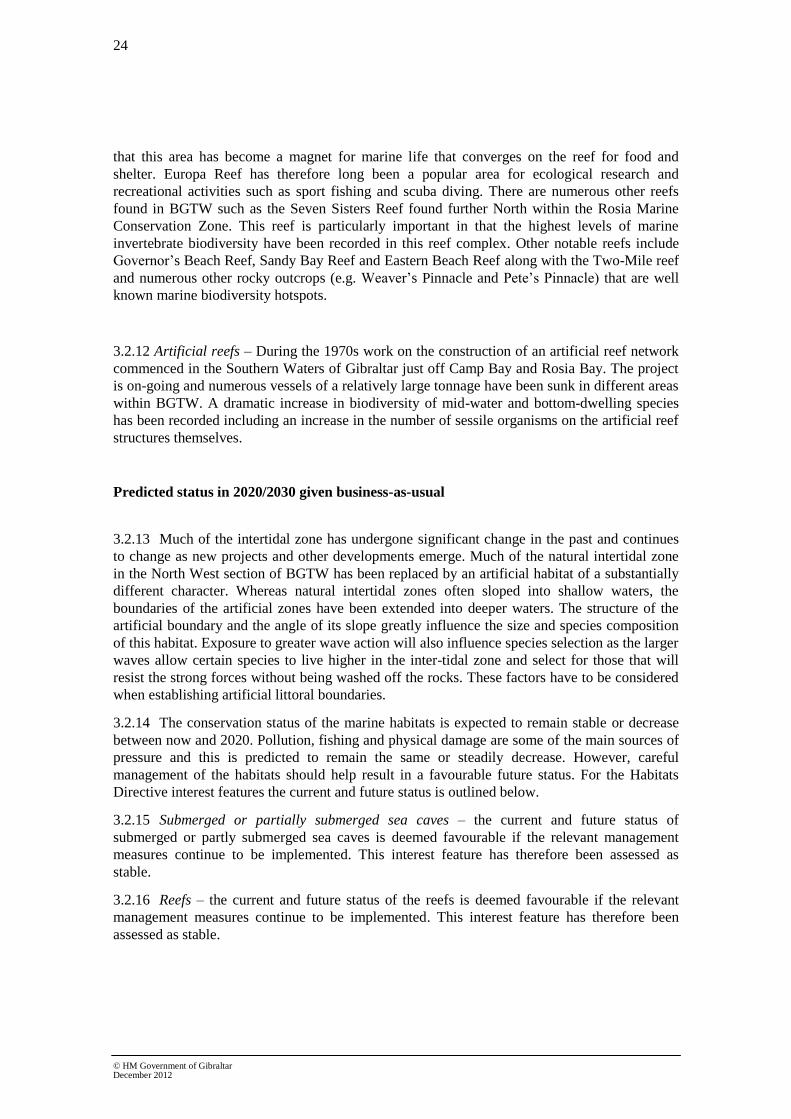
24
© HM Government of Gibraltar December 2012
that this area has become a magnet for marine life that converges on the reef for food and
shelter. Europa Reef has therefore long been a popular area for ecological research and
recreational activities such as sport fishing and scuba diving. There are numerous other reefs
found in BGTW such as the Seven Sisters Reef found further North within the Rosia Marine
Conservation Zone. This reef is particularly important in that the highest levels of marine
invertebrate biodiversity have been recorded in this reef complex. Other notable reefs include
Governor’s Beach Reef, Sandy Bay Reef and Eastern Beach Reef along with the Two-Mile reef
and numerous other rocky outcrops (e.g. Weaver’s Pinnacle and Pete’s Pinnacle) that are well
known marine biodiversity hotspots.
3.2.12 Artificial reefs – During the 1970s work on the construction of an artificial reef network
commenced in the Southern Waters of Gibraltar just off Camp Bay and Rosia Bay. The project
is on-going and numerous vessels of a relatively large tonnage have been sunk in different areas
within BGTW. A dramatic increase in biodiversity of mid-water and bottom-dwelling species
has been recorded including an increase in the number of sessile organisms on the artificial reef
structures themselves.
Predicted status in 2020/2030 given business-as-usual
3.2.13 Much of the intertidal zone has undergone significant change in the past and continues
to change as new projects and other developments emerge. Much of the natural intertidal zone
in the North West section of BGTW has been replaced by an artificial habitat of a substantially
different character. Whereas natural intertidal zones often sloped into shallow waters, the
boundaries of the artificial zones have been extended into deeper waters. The structure of the
artificial boundary and the angle of its slope greatly influence the size and species composition
of this habitat. Exposure to greater wave action will also influence species selection as the larger
waves allow certain species to live higher in the inter-tidal zone and select for those that will
resist the strong forces without being washed off the rocks. These factors have to be considered
when establishing artificial littoral boundaries.
3.2.14 The conservation status of the marine habitats is expected to remain stable or decrease
between now and 2020. Pollution, fishing and physical damage are some of the main sources of
pressure and this is predicted to remain the same or steadily decrease. However, careful
management of the habitats should help result in a favourable future status. For the Habitats
Directive interest features the current and future status is outlined below.
3.2.15 Submerged or partially submerged sea caves – the current and future status of
submerged or partly submerged sea caves is deemed favourable if the relevant management
measures continue to be implemented. This interest feature has therefore been assessed as
stable.
3.2.16 Reefs – the current and future status of the reefs is deemed favourable if the relevant
management measures continue to be implemented. This interest feature has therefore been
assessed as stable.

25
© HM Government of Gibraltar December 2012
State of the evidence base and development needs
The assessment of intertidal and seabed habitats was largely based on a combination of
information gathered from the reports in Box 2.2, and expert judgement, considering the
relationship between habitats and pressures and drawing upon evidence from monitoring studies
and research. The many uncertainties will be greatly reduced and the approach enhanced
through more robust evidence on the distribution and intensity of pressures. The threshold
values, against which habitats were judged in the above assessment were derived from
assessments carried out in line with the related obligations of the Habitats Directive.
Box 3.1 Bibliography
Casier, R. (2011) Marine Protected Areas in the Mediterranean Sea, study awarded by EUROPARC Conference 2011 and made possible by Alfred Toepfer Stiftung F.V.S
DoE, Gibraltar & Environmental Agency, Gibraltar (2008) Climate Change: The Gibraltar Programme.
Cebrián, E., and Ballesteros, E. Zonation patterns of benthic communities in an upwelling area from the western Mediterranean (La Herradura, Alboran Sea), Scientia Marina, 68(1), 69-84
Fa, D.A. and Finlayson, G. (2008) Marine Surveillance – Diving and Intertidal Survey.Final report prepared by The Gibraltar Museum for The Ministry of Environment.
Department of the Environment.Government of Gibraltar. 2012. Southern Waters of Gibraltar Management Scheme. EU Natura 2000 Site. Dual SAC/SPA. [http://www.gibraltar.gov.gi/images/stories/PDF/environment/Southern_Waters_of_Gibraltar_Management_Scheme_2012.pdf]
Halcrow (2007) Eastside Environmental Statement.
Perez, C.E. (2006) Biodiversity Action Plan, Gibraltar: Planning for Nature, The Gibraltar Ornithological & Natural History Society, Gibraltar.
Shaw, E. (1996) The Gibraltar Artificial Reef: Habitat Manipulation. Almoraima. 15: 197-204.
Wildlife (Gibraltar) Ltd (2007) Six-year report for the EC Habitats Directive 2000-2006: Gibraltar, report for the Government of Gibraltar

26
© HM Government of Gibraltar December 2012
Figure 3.1 Spatial distribution of reefs in the Southern Waters of Gibraltar.
Source: Southern Waters of Gibraltar Management Scheme (2012)

27
© HM Government of Gibraltar December 2012
Figure 3.2 Spatial distribution of submerged or partially submerged caves in the Southern
Waters of Gibraltar.
Source: Southern Waters of Gibraltar Management Scheme (2012)

28
© HM Government of Gibraltar December 2012
3.3 Biological features (Descriptors 1, 4 and 6)
3.3.1 BGTW are an important migratory route for avian, airborne invertebrate and marine
species.
3.3.2 The hydrological regime within the Bay of Gibraltar is complex and this, coupled with
nutrient rich water up-wellings, has led to a mixture of African, Atlantic and Mediterranean
species co-existing in the Bay.
Benthic invertebrates
3.3.3 Under Annex III of the MSFD the characteristics for benthic invertebrates are described
as follows:
• a description of the biological communities associated with the predominant
seabed and water column habitats. This would include information on the
phytoplankton and zooplankton communities, including the species and seasonal
and geographical variability;
• information on angiosperms, macro-algae and invertebrate bottom fauna,
including species composition, biomass and annual/seasonal variability; and
• a description of the population dynamics, natural and actual range and status of
other species occurring in the marine region or sub-region which are the subject of
Community legislation or international agreements.
Key pressures
3.3.4 The main pressures on the benthic invertebrate communities of Gibraltar are abrasion,
collection, contamination by hazardous substances and illegal fishing activities.
Current status and trends
3.3.5 The rocky shorelines and off-shore reefs within BGTW provide ideal habitats for benthic
marine invertebrates. The rocky littoral to the sub-littoral zone and rocky reefs reveal a rich bio-
diversity of benthic species; surveys and observations have recorded the presence of mussels,
echinoderms, nudibranchs, hermit crabs, spider crabs, winkles, triton snails, top shells, limpets,
barnacles, sea anemones, soft corals and sea fans.
3.3.6 Within BGTW and particularly within the Southern Waters of Gibraltar (a dual SAC and
SPA) the Department of the Environment is monitoring the quality of coastal water as part of
Gibraltar’s obligations under the Water Framework Directive 2000/60/EC.
3.3.7 Surveys undertaken for the WFD found three main communities around the coast of
Gibraltar:
• Well sorted or very shallow sands Characteristic species of this community
present in the samples include the amphipods Hippomedon massiliensis and
Siphonoecetes dellavallei, the decapod Diogenes pugilator and the polychaete
Prionospio malmgreni.
• Transitional community between well sorted or very shallow sands and coastal
detritic bottoms . Characteristic species of this community which have been found
include the decapod Diogenes pugilator and the polychate Sigalion mathildae.

29
© HM Government of Gibraltar December 2012
• Transitional community between muddy sands in protected areas and shallow
coastal terrigenous mud . Characteristic species found include the bivalves Paphia
aurea and Nucula sulcate, the amphipod Leptocheirus pectinatus and the
polychaetes Paradoneis lyra and Heteromastus filiformis.
3.3.8 In deeper, subtidal waters, historic conch raking off the East side of Gibraltar has had a
considerable negative impact on its ecological diversity and abundance. The regular disturbance
means there are poor epi-benthic communities and a lack of large slow growing bivalve and
gastropod species. Commercial fishing is banned in BGTW by Gibraltar law but Spanish
registered commercial fishing boats still partake in illegal fishing practices. .
3.3.9 Several benthic species found within BGTW are designated as protected under schedule
IV of the Habitats Directive. These are discussed in detail below.
Patella ferruginea - Ribbed Mediterranean limpet
3.3.10 The coast of Gibraltar provides one of the largest single populations of this gastropod
within the Iberian Peninsula which is endemic to the Mediterranean Sea. It is found adhered to
rocks in the mid- to supralittoral zones, tends to avoid areas that are too exposed to wave action
and favours areas of highly oxygenated water.
3.3.11 P. ferruginea is listed in Annex IV of the Habitats Directive and is found in numerous
locations within BGTW.
3.3.12 Anthropogenic impacts (i.e. abrasion, collection, chemical and biological
contamination) coupled with its low growth and reproductive rates, threaten P. ferruginea with
extinction. Because it is so sensitive to changes in the environment, it is proposed as a bio-
indicator of environmental quality.
3.3.13 The North Mole/airport runway is considered as a ‘hotspot’ for P. ferruginea possibly
due to its restricted access which may have allowed the population in that area to reach a more
balanced sex-ratio and act as a ‘source’ for new populations. There are other populations around
the coast of Gibraltar including within the Southern Waters of Gibraltar SAC/SPA.
Pinna nobilis & Pinna rudis – Fan mussels
Pinna nobilis is also endemic to the Mediterranean Sea. It is a large bivalve (80 cm to 1 m)
living solitarily in soft sandy and sometimes maërl /mud substrate between 3 and 40 m deep
(although mostly deeper than 20 m). P. nobilis is listed in Annex IV of the Habitats Directive
and is particularly found in the Southern Waters of Gibraltar (SAC/SPA). The mussels half bury
themselves into the substrate anchored by their byssus threads. The upper half then stands out of
the substrate and they filter feed. They are thought to avoid areas of high sediment transfer loads
and seem to only be found on the west side in the Bay of Gibraltar. There exists a closely-related
species of fan mussel in BGTW which is Pinna rudis. This species is also in regression and although not
listed in Annex IV of the EU Directive 92/43/CEE, it is included in the subsequent Barcelona (Protocol
concerning Specially Protected Areas and Biological Diversity in the Mediterranean 1999 – Annexe II)
and Bern Conventions (on the conservation of European wildlife and natural habitats 1998 – Annexe II).
3.3.14 On the southwest P. rudis is found near the warm hypersaline outfall just north of the
Nuffield Pool complex. It is thought that the warm water is more productive, providing an ideal
environment for a filter feeder.
3.3.15 Historic populations of P. nobilis were reported in sea grass meadows in the Bay of
Gibraltar; however these meadows have all but disappeared and it is assumed that this is partly

30
© HM Government of Gibraltar December 2012
to blame for the serious decline of P. nobilis seen in recent years. Other anthropogenic factors
are also thought to contribute towards this decline (trawling, overfishing, and pollution); indeed
they are found in the vicinity of shipwrecks and rocky outcrops, presumably because these areas
are not trawled and so individuals in these areas are not removed.
Lithophaga lithophaga – Date mussel
3.3.16 The date mussel (L. Lithophaga) is listed in Annex IV of the Habitats Directive and is
found in coastal regions of the Atlantic Ocean as well as the Mediterranean Sea. It bores 10-20
cm holes into limestone rocks and subsequently inhabits them. Due to its geology the Gibraltar
region harbours a significant population of date mussels. It seems to prefer areas with strong
currents and low sediment and is less common on the East side of Gibraltar where the currents
are stronger. Studies have shown that L. lithophaga is present in most limestone and limestone-
derived benthic substrates found in BGTW.
3.3.17 The tunnels and holes made by L. lithophaga in the rocks provide shelter in which other
marine organisms can breed and feed, thus without the date mussel the diversity of communities
on limestone rocks would be severely reduced.
3.3.18 The mussel is endangered and the main cause is thought to be its collection for human
consumption; this is exacerbated by its slow growth rate which makes it unsuitable for
commercial breeding (it takes 15 to 20 years to reach 5 - 6 cm). Harvesting of date mussels has
been banned in most Mediterranean countries as it leads to the destruction of the limestone
rocks in which it is found. This damages the ecosystem and, due to the mussel’s slow growth
rate, this effect is near impossible to rectify.
Centrostephanus longispinus- long-spined sea urchin
3.3.19 C. Longispinus is considered a rare species and is listed in Annex IV of the Habitats
Directive.
3.3.20 C. longispinus has a wide distribution throughout the western Mediterranean and is
usually found in rocky or detritic/maërl habitats, in the depth range of 5 – 200 m, although most
commonly at depths greater than 25 m, with the densest populations observed between 60 – 180
m.
3.3.21 Due to its long spines and its preference for deep water habitats, C. longispinus is not an
ideal prey and is also not commonly harvested by man due to the inaccessible depths where it is
more commonly found.
Predicted status in 2020/2030 given business-as-usual
3.3.22 The population of P. ferruginea is increasing. Although usually found on natural rocky
shores, it has colonised artificial rocky shores that are served well by strong currents thus
reducing the pollution encountered. Although this is positive there is no evidence to suggest that
the substrate is more suitable than natural rocky coasts, but does suggest the species is
adaptable. Ongoing monitoring is being carried out to determine optimal conditions for
colonisation.
3.3.23 Apart from the other listed species which are considered rare and endangered, there is
no clear information on the status of other invertebrates found in BGTW.

31
© HM Government of Gibraltar December 2012
State of the evidence and development needs
3.3.24 The data pertaining to benthic invertebrate species is drawn mainly from field work
researching the presence and abundance of such species in BGTW. Research has been
promulgated by the requirements of the Habitats Directive and the WFD amongst other EU
Directives that have been transposed in Gibraltar.
3.3.25 More resources are required to police BGTW and curb illegal practices.
Box 3.2 Bibliography
Fa, D.A. and Finlayson, G. (2008) Marine Surveillance – Diving and Intertidal Survey, final report prepared by The Gibraltar Museum for The Ministry of Environment
Fa, D.A. and Finlayson, G (2011) Benthic Invertebrate Sampling – Establishing EcoQs for Gibraltar Waters, final report prepared by The Gibraltar Museum for The Ministry of Environment
Department of the Environment. Government of Gibraltar. 2012. Southern Waters of Gibraltar Management Scheme. EU Natura 2000 Site. Dual SAC/SPA.
Halcrow, Eastside, Gibraltar Environmental Statement, July 2007.
Wildlife (Gibraltar) Ltd (2007) Six-year report for the EC Habitats Directive 2000-2006: Gibraltar, report for the Government of Gibraltar
Fish communities
3.3.26 Under Annex III of the MSFD the characteristics for fish are described as follows:
• information on the structure of fish populations, including the abundance,
distribution and age/size structure of the populations.
Key pressures
3.3.27 The main pressures on the fish communities of Gibraltar are illegal commercial fishing,
recreational fishing and pollution.
3.3.28 At present, where monitoring has been undertaken, Gibraltar’s ecological status has
been relatively positive. Assessments carried out as part of the WFD have generally shown good
water quality. However, research into marine pollution in fish species including shellfish is
ongoing. Elevated levels of heavy metals and hydrocarbon in some areas have the potential to
bio-accumulate throughout the food chain. A fish and shellfish monitoring programme has
therefore been launched by the Department of the Environment, the results of which will be
used for future assessments of fish communities in BGTW.
3.3.29 The creation of artificial reefs is likely to have been beneficial to fish and other marine
species, creating environments for smaller reef fish that then attract larger predatory species into
BGTW. The artificial reef programme is still in operation and new reefs are currently being
planned.
Current status and trends
3.3.30 There is very little information on the current status of fish communities in BGTW. A
separate report looking at the management of marine living resources in BGTW has been
produced by an independent Fishing Expert Working Group (Tydeman & Lutchman, 2013) and
this report arrived at similar conclusions to the Initial Assessment in that the data available have
been insufficient in providing clear trends.

32
© HM Government of Gibraltar December 2012
3.3.31 The most common habitat found within BGTW are sandy habitats covering a large part
of the eastern and western sides of BGTW. Characteristic fish species found over sandy habitats
are shown in Table 3.1.
Table 3.1 Main fish species found over or on sandy benthic habitat. Source: BAP, Gibraltar.
Scientific name Common name
Echiichthys vipera Lesser Weaver
Trachinus draco Greater Weaver
Uranoscopus scaber Stargazer
Engraulis encrasicolus European Anchovy
Sardina pilchardus European Pilchard
Chelon labrosus Thick-lipped Grey Mullet
Pagellus acarne Bronze Bream
Spondyliosoma cantharus Black Bream
lithognathus mormyrus
Raja clavata
Torpedo marmorata
Solea solea
Sygnathus spp
Striped Sea Bream
Thornback ray
Marbled electric ray
Common sole
Pipefish
3.3.32 The currents and upwellings within the Strait and the Alboran Sea bring nutrients that
stimulate the growth of plankton and thus attracting a variety of pelagic fish (Table 3.2).
Table 3.2 Main pelagic fish found in the Strait of Gibraltar. Source: BAP, Gibraltar.
Scientific name Common name
Trachinotus ovatus Pompano
Trachurus mediterraneus Mediterranean horse mackerel
Trachurus picturatus Blue jack mackerel
Trachurus trachurus Atlantic horse mackerel
Spicara flexuosa Picarel
Spicara maena Blotched picarel
Pomatomus saltatrix Bluefish
Scomberesox saurus Atlantic saury
Auxis rochei Bullet tuna
Euthynnus alletteratus Little tunny
Katsuwonus pelamis Skipjack tuna
Sarda sarda Atlantic bonito
33
© HM Government of Gibraltar December 2012
Scomber japonicas Chub or Spanish mackerel
Scomber scombrus Atlantic mackerel
Thunnus alalunga Albacore
Thunnus thynnus Northern bluefin tuna
Thunnus albacores Yellowfin tuna
Xiphias gladius
Mola mola
Swordfish
Sunfish
3.3.33 Rocky outcrops found on the sandy sea bed also attract an array of marine life, including
fish such as grouper, sea breams, scorpion fish, cardinal fish, conger and moray eels, rays,
gobies, blennies and sunfish amongst many other species.
Predicted status in 2020/2030 given business-as-usual
3.3.34 As there are currently limited data on the populations of fish in BGTW, predicting the
status in future years is difficult. Fish tagging programmes have been implemented in BGTW
targeting species such as the European sea bass (Dicentrarchus labrax) although further
monitoring is required to accurate assess fish stocks.
State of the evidence and development needs
3.3.35 There are limited data available on fish populations in BGTW. However the
Government of Gibraltar is seeking to redress this situation by implementing a series of
additional fisheries management measures in line with the requirements of the Marine
Protection Regulations, as well as habitat enhancement measures. An overview of the fisheries
management measures that are currently being implemented in BGTW is provided by Tydeman
& Lutchman, 2013.
Box 3.3 Bibliography
Casier, R. (2011) Marine Protected Areas in the Mediterranean Sea, study awarded by EUROPARC Conference 2011 and made possible by Alfred Toepfer Stiftung F.V.S DoE, Gibraltar & Environmental Agency, Gibraltar (2008) Climate Change: The Gibraltar Programme
Department of the Environment. Government of Gibraltar. 2012. Southern Waters of Gibraltar Management Scheme. EU Natura 2000 Site. Dual SAC/SPA.
Gibraltar Ornithological & Natural History Society (1999) Commercial Fishing and the Conservation of Marine Life in the Waters around Gibraltar
Halcrow (2007) Eastside Environmental Statement
Perez, C.E. (2006) Biodiversity Action Plan, Gibraltar: Planning for Nature, The Gibraltar Ornithological & Natural History Society, Gibraltar
Tydeman, C. & Lutchman, I.2013. The Management of Marine Living Resources in the waters around Gibraltar.
Wildlife (Gibraltar) Ltd (2007) Six-year report for the EC Habitats Directive 2000-2006: Gibraltar, report for the Government of Gibraltar

34
© HM Government of Gibraltar December 2012
Cetaceans and reptiles
3.3.36 Under Annex III of the MSFD the characteristics for cetaceans and reptiles are
described as follows:
• a description of the population dynamics, natural and actual range and status of
species of marine mammals and reptiles occurring in the marine region or sub
region.
Key pressures
3.3.37 Disturbance by and possible collision with sea users such as commercial ships and
dolphin and whale tour operators. Habitat loss and degradation due to the reclamation of the
Bay, and areas within the harbour. Pollution by industrial and commercial activities undertaken
around the Bay area. Although fishing with nets is banned in BGTW, there is still a risk of
entanglement and trapping since fishing nets are known to be used illegally in BGTW.
Current status and trends
Ceteceans
3.3.38 Cetaceans are common throughout all of BGTW. Both Common Dolphin Delphinus
delphis and Striped Dolphin Stenella coerulaeoalba have nurseries within the Bay (Shaw,
1998). The most common species that are recorded are listed in Table 3.3 below.
Table 3.3 Main cetacean species seen in BGTW.
Scientific name Common name
Delphinus delphis Common Dolphin
Globicephala melas (melaena) Long-finned Pilot Whale
Grampus griseus Risso's Dolphin
Orcinus orca Killer Whale
Stenella coeruleoalba Striped Dolphin
Tursiops truncatus Bottle-nosed Dolphin
Physeter macrocephalus Sperm Whale
Ziphius cavirostris Cuvier's Beaked Whale
Balaenoptera acutorostrata Northern Hemisphere Minke Whale
Balaenoptera physalus Fin Whale
Megaptera novaeangliae Humpback Whale
3.3.39 Many of these cetaceans migrate through BGTW throughout the year so defining
numbers is difficult. The Department of the Environment together with the Gibraltar Port
Authority implements a Dolphin and Whale Protocol that is imposed on all operators within
BGTW. Species that are regularly found in BGTW include the common, striped and bottle
nosed dolphins. Whales also frequent BGTW but are more commonly seen in the Strait of
Gibraltar and on the eastern side of the Rock. Small resident populations of sperm whales, killer
whales and long-finned pilot whales are found in the Strait of Gibraltar. The Department of the

35
© HM Government of Gibraltar December 2012
Environment gathers data from numerous research entities operating within BGTW, and the
wider region, in order to monitor the status of cetacean populations in BGTW.
Results of cetacean monitoring programmes are reported in line with the requirements of the
Habitats Directive.
Sea Turtles
3.3.40 Green (Chelonia mydas), loggerhead (Caretta caretta) and leatherback turtles
(Dermochelys coriacea) are recorded in BGTW, with the loggerhead turtle being the most
frequently recorded species. These are predominantly migratory visitors To date, no turtle
nesting sites along the coast of Gibraltar have been reported.
Predicted status in 2020/2030 given business-as-usual
3.3.41 The assessment undertaken for the Habitats Directive considers the current conservation
status of the bottlenose dolphin populations that live in the Bay as ‘inadequate’, despite the
habitat being considered as ‘favourable’. This is used as a proxy for the other cetacean species
that frequent the Bay and the Straits, and indicates that a holistic approach to management of the
key pressures is needed if populations and individuals are not to be further impacted by the key
pressures.
All three species of sea turtle recorded in BGTW are listed as endangered, and as with the
bottlenose and other dolphin species in BGTW, a conservation status of ‘inadequate’ has been
designated for marine reptiles.
State of the evidence and development needs
Foraging and breeding areas of cetaceans within BGTW and the Bay of Gibraltar generally
require strict monitoring and enforcement, particularly in relation to fishing and maritime
activities that could affect cetaceans and marine reptiles. Marine Conservation Zones have been
designated within BGTW and this should assist in helping conserve important habitats used by
both cetaceans and marine reptiles. Further research and regional co-operation is also required
to help improve the conservation status of cetaceans and marine reptiles in BGTW and the
wider region.
Box 3.4 Bibliography
Department of the Environment. Government of Gibraltar. 2012. Southern Waters of Gibraltar Management Scheme. EU Natura 2000 Site. Dual SAC/SPA.
Perez, C.E. 2006. Biodiversity Action Plan, Gibraltar: Planning for Nature. The Gibraltar Ornithological & Natural History Society. Gibraltar.
Shaw, E. 1998. Dolphins in the Bay of Gibraltar. Almoraima, 19: pp. 161-71.
Wildlife (Gibraltar) Ltd. 2007. Six-year report for the EC Habitats Directive 2000-2006: Gibraltar, report for the Government of Gibraltar
Phytoplankton
3.3.42 Under Annex III of the MSFD the characteristics for phytoplankton are described as
follows:
36
© HM Government of Gibraltar December 2012
• all elements of the marine food webs, to the extent that they are known, occur at
normal abundance and diversity and levels capable of ensuring the long-term
abundance of the species and the retention of their full reproductive capacity.
Key Pressures
3.3.43 High levels of nitrogen and phosphorus contamination, such as raw sewerage and
fertilisers are some of the major pressures on phytoplankton populations. Increased nutrient load
creates an environment where phytoplankton can grow and become superabundant. This leads
to eutrophication and significantly degrades the biological communities in the affected areas.
3.3.44 Phytoplankton also uptakes heavy metal contamination found in the water column, this
is then transferred through the food chain, accumulating in higher species.
3.3.45 Changes in water quality impact phytoplankton species composition and abundance and
react quickly to any changes that occur. Due to their responsive nature, phytoplankton
communities recover well when adverse conditions improve, so that the main implication of
changes to phytoplankton communities is the impact on the wider ecosystem. Phytoplankton is
the main food resource in most marine ecosystems and alterations to communities can have
wide ranging and longer lasting effects on the species which feed on them.
Current Status and Trends
3.3.46 Phytoplankton numbers and concentration in BGTW have been monitored as part of the
wider Water Framework Directive monitoring programme. Phytoplankton is the main food
resource for many marine food webs. It is important for both pelagic and benthic ecosystems,
providing an abundant food resource for smaller fish and invertebrates which then support
larger species. Phytoplankton is also an important indicator species which can provide a good
deal of information on the health and status of a marine environment, particularly water quality
in the area.
3.3.47 Regional currents and upwelling ensure regular nutrient input into BGTW waters thus
preventing stagnation and detrimental nutrient depletion.
3.3.48 Diatoms are the most commonly recorded type of phytoplankton, with high levels of
microflagellates also being present. Levels of chlorophyll a remain constant for much of the
year, with very short lived blooms at most sites in February and higher levels of Chlorophyll a
also being recorded in the summer months and November. However, the magnitude and timings
of these blooms alter between the different sites monitored in BGTW. Winter and spring blooms
are common in the Mediterranean as opposed to the spring/summer blooms seen in UK waters.
3.3.49 Recorded levels of chlorophyll a indicate a high ecological status at all sites sampled
and it would suggest that the input of additional nutrients from sewage or other point sources is
not adversely affecting phytoplankton communities in BGTW.
State of evidence and development needs
3.3.50 Monthly monitoring since for chlorophyll a, dissolved oxygen, dissolved inorganic
nitrogen, temperature, pH and suspended sediment has been undertaken as part of the Water
Framework Directive. Quarterly sampling for heavy metal, hydrocarbon and pesticide
contaminants has also been undertaken. Although it is difficult to interpret trends from the data
collected to date, they have provided a good background to compare further years’ data and
assess trends.
3.3.51 The ecological status of phytoplankton communities in BGTW is considered to be high
and so there is no action required to improve the ecological status of phytoplankton

37
© HM Government of Gibraltar December 2012
communities in BGTW. Continued monitoring will identify any negative trends which may
need to be acted upon.
Box 3.5 References used
Government of Gibraltar (2011) Water Framework Directive Annual Monitoring Report 2010-2011. Produced by AMEC for the Department of Environment Gibraltar
Government of Gibraltar (2011) River Basin Management Plan, report produced by AMEC for the Department of Environment, Gibraltar.
Perez, C.E. (2006). Biodiversity Action Plan, Gibraltar: Planning for Nature. The Gibraltar Ornithological & Natural History Society. Gibraltar.
Algae
3.3.52 Under Annex III of the MSFD the characteristics for algae are described as follows:
• all elements of the marine food webs, to the extent that they are known, occur at
normal abundance and diversity and levels capable of ensuring the long-term
abundance of the species and the retention of their full reproductive capacity.
Key Pressures
3.3.53 A major concern with algae is the uptake of contaminants, in particular heavy metals.
Algae, particularly brown algae are efficient in the uptake of heavy metals which can then
accumulate in their tissues; these contaminants are then passed onto grazing invertebrates and
fish.
3.3.54 The loss of coastal habitat due to the replacement of natural coastal areas with coastal
defences and sea walls is likely to cause some shifts in algal communities. This will be both a
short term pressure from habitat disturbance and potentially a long term pressure as different
algal communities may thrive on anthropogenic structures.
3.3.55 Changes to algal community structure can have widespread and detrimental effects on
invertebrate and grazing fish species that depend on algal habitats. Loss or changes to species
composition caused by changes to substratum and coastal structures are a particular pressure.
Current status and trends
3.3.56 Algae are a fundamental base element to many marine food chains, in a similar way to
phytoplankton, they also provide habitat in otherwise exposed sandy and rocky areas. Algae are
of particular importance in intertidal and subtidal areas, providing important grazing, sheltering
and nursery habitats for invertebrate species.
3.3.57 Assessments of algal communities around Gibraltar have been carried out, including
assessments on the use of algal communities as bioindicators of marine pollution (e.g. Green;
2001, Warr; 2004). A mix of Atlantic and Mediterranean type algal communities typical of
intertidal rocky shores and shallow subtidal rocky reefs are found in BGTW. Notable species
which have been found in BGTW include the increasingly rare Cystoseira mediterranea which
is listed as an Annex II species under the SPAMI15
Protocol. It is a fucoid algae with a highly
branched structure providing important habitats for numerous species of inter- and subtidal
15
List of Specially Protected Areas of Mediterranean Importance

38
© HM Government of Gibraltar December 2012
invertebrates. C. mediterranea depends on good water quality and can be used as a bioindicator
to assess the levels of water quality in the coastal area.
Predicted status in 2020/2030 given business-as-usual
3.3.58 At present, there is no evidence to suggest that algal communities are unhealthy. The
presence of the bioindicator C. Mediterranea in parts of the Southern Waters of Gibraltar
suggests that water quality is typically good. Further monitoring on the presence and
distribution of this sand other algal species will provide valuable information on upwards or
downwards trends in water quality.
3.3.59 An increase in coastal developments and addition of coastline through land reclamation
could be a double edge sword. On one hand there is an initial destruction and disturbance of
habitat, however, the structures that are built in replacement are likely to offer some suitable
settling ground.
3.3.60 Increases in population, infrastructure and tourist facilities may increase pressure on
coastal areas. The intertidal habitat needs to be managed to avoid habitat loss.
State of the evidence and development needs
3.3.61 There is a need to further expand the algae monitoring network into deeper areas within
BGTW. This will help assess the impacts of key pressures in BGTW. Further research on
intertidal algal communities is also required. These measures will help mitigate the potential
impacts of replacing of natural coastal structures with anthropogenic ones that may cause shifts
in algal community structure.
Box 3.6 References used
Perez, C.E. 2006. Biodiversity Action Plan, Gibraltar: Planning for Nature. The Gibraltar Ornithological & Natural History Society. Gibraltar.
Green, E. 2001. An investigation into the use of marine algae as an indicator of pollution. Imperial College of Science, Technology and Medicine. Unpubl.
Warr, S. 2004. An investigation into the impacts of wastewater using intertidal macro-flora and fauna. Undergraduate thesis. University of Southampton. Unpubl.
Seabirds
3.3.62 Under Annex III of the MSFD the characteristics for seabirds are described as follows:
• a description of the population dynamics, natural and actual range and status of
species of seabirds occurring in the marine region or sub region.
Key pressures
3.3.63 Disturbance to breeding sites and feeding areas from recreational craft, fishing boats,
divers and maritime traffic are the main pressures. Oil spills in particular are the largest threat to
seabirds, especially the Mediterranean shag, whose population in Gibraltar is one of the
remaining few in the mainland Iberian Peninsula. Potential sources of oil spills include the oil
refinery located in the Northern end of the Bay and the intense maritime traffic passing through
BGTW either in transit or for refuelling purposes within the Bay. In order to prevent any
potential discharges to the marine environment, the Port of Gibraltar in conjunction with the
Gibraltar Maritime Administration operate a strict inspection and enforcement regime in line
conformity with applicable EU legislation along with the Bunkering Code of Practice and the
Port Rules. Fishing methods, such as purse seines, trammel and drift nets, deployed by Spanish

39
© HM Government of Gibraltar December 2012
fishing vessels are also a key threat to the Mediterranean shag and the numerous other seabirds
found in BGTW as outlined below.
Current status and trends
3.3.64 British Gibraltar’s Territorial Waters, particularly the Southern Waters of Gibraltar
SAC/SPA, are an important feeding ground for migratory birds that continuously fly through
the Straits of Gibraltar.
3.3.65 Each year an estimated c.300 million birds pass over the Strait of Gibraltar in each
direction.
3.3.66 Some species, such as the Cory’s shearwater, forage in the Southern Waters of Gibraltar
SAC/SPA whilst breeding. Other species, such as Gannets, Black-headed Gulls and Sandwich
Terns for example, rely on the nutrient-rich productive waters for feeding in winter months.
3.3.67 .
3.3.68 Many of the seabirds that use BGTW are listed in the EU Birds Directive, these include:
• Cory’s shearwater
• Black tern
• Gull-billed tern
• Audouin’s gull
• Mediterranean gull
• Common scoter
• Mediterranean shag
• Cormorant
• Balearic shearwater
• Little tern
• Caspian tern
• Common tern
• Sandwich tern
• Yelkouan shearwater
The status of these and other seabird species in BGTW is reported as part of the Article 17
Reporting Process in line with the requirements of the Habitats Directive. In view that the
Mediterranean Shag is the only seabird that breeds in Gibraltar (along with the Yellow-legged
Gull which has a more widespread distribution), further particulars are provided below.
Mediterranean shag
3.3.69 Although the shag in general has a favourable status, the Mediterranean shag has a
restricted global distribution. Gibraltar hosts one of the few remaining breeding colonies for the
Mediterranean shag in the mainland Iberian Peninsula with a small population (5-10 pairs) using
the sea caves on the East side of the Rock. As such under Gibraltar’s Biodiversity Action Plan, a

40
© HM Government of Gibraltar December 2012
Species Action Plan has been prepared for the Mediterranean shag. This plan incorporates clear
steps that are being taken to enhance their survival.
3.3.70 The population has suffered declines in the past but is now considered stable.
Predicted status in 2020/2030 given business-as-usual
The population of Mediterranean Shag in Gibraltar is small, so any fatalities would have a major impact on the future success of the resident population.
State of the evidence and development needs
3.3.72 The Department of the Environment is provided with data collected by the Gibraltar
Ornithological & Natural History Society (GONHS), which continuously assesses which Annex
I or regularly occurring migratory bird species occur in BGTW. Ornithological research within
GONHS is co-ordinated by the Strait of Gibraltar Bird Observatory. This is divided into
monitoring and research with emphasis on the migration of passerines, seabirds and raptors and
an annual passerine ringing programme. The GONHS has a database of records dating back to
the 1960's and publishes an annual account of avian records in Gibraltar including the Southern
Waters of Gibraltar (Gibraltar Bird Report). Additionally, records of note are published online
[http://www.gonhs.org/records.htm].
3.3.71 The Southern Waters of Gibraltar have been designated as a dual SAC/SPA, affording
the nesting site for the Mediterranean shag some protection. Ongoing monitoring is required,
and this would benefit from enhancement of the nesting site and a reduction in human
disturbance.
3.3.72 There needs to be improved monitoring of maritime traffic and fuel management and
enforcement of laws with regards to net fishing.
Box 3.7 References used
Casier, R. (2011) Marine Protected Areas in the Mediterranean Sea, study awarded by EUROPARC Conference 2011 and made possible by Alfred Toepfer Stiftung F.V.S DoE, Gibraltar & Environmental Agency, Gibraltar (2008) Climate Change: The Gibraltar Programme
Department of the Environment. Government of Gibraltar. Southern Waters of Gibraltar Management Scheme. EU Natura 2000 Site. Dual SAC/SPA.
Halcrow (2007) Eastside Environmental Statement
Perez, C.E. (2006) Biodiversity Action Plan, Gibraltar: Planning for Nature, The Gibraltar Ornithological & Natural History Society, Gibraltar
Wildlife (Gibraltar) Ltd (2007) Six-year report for the EC Habitats Directive 2000-2006: Gibraltar, report for the Government of Gibraltar
3.4 Non-indigenous species (Descriptor 2)
3.4.1 Under Annex III of the MSFD the characteristics for non-indigenous species is to be
described as follows:
• an inventory of the temporal occurrence, abundance and spatial distribution of
non-indigenous, exotic species or, where relevant, genetically distinct forms of
native species, which are present in the marine region or subregion.

41
© HM Government of Gibraltar December 2012
Current status and trends
3.4.2 There is insufficient information currently available to properly assess the current status
of non-indigenous species in the waters of Gibraltar.
3.4.3 A species is classed as non-indigenous when it is found in an area that is outside of its
normal dispersion potential. For the marine environment this may come about by the
introduction of species to new areas through attachment to boats (bio-fouling), through the
expulsion of ballast water and introduction by man through aquaculture or unwanted pets. These
species have the potential to out-compete indigenous species for habitat and prey. As such they
are considered a threat to biodiversity and may be costly to manage.
3.4.4 The Strait of Gibraltar is the main shipping channel into and out of the Mediterranean
from the Atlantic Ocean. As such the opportunity for non–indigenous species to arrive attached
to ships or in ballast water is high.
3.4.5 As sea temperatures rise, it is anticipated that there will be an increase in the introduction
and range expansion of non-indigenous species with unknown consequences for biodiversity,
ecosystem functioning and living marine resources.
3.4.6 Localised gyres and currents mean the physical conditions in the West Mediterranean
area are not suitable for the permanent settlement of all species that may end up there. A recent
study (Zenetos et al, 2010) summarised the following numbers of non-indigenous species found
in the Western Mediterranean sub-region, which includes Gibraltar:
• 4 pathogenic protozoa;
• 91 macrophytes;
• 49 polychaetes;
• 52 crustacea;
• 34 molluscs;
• 23 miscellaneous invertebrates (i.e. bryozoans, anemones, echinoderms); and
• 45 fish.
3.4.7 It is currently not clear how many of these are found in Gibraltar’s territorial waters, and
how many are a real threat to indigenous species. Intertidal ecology research has nevertheless
shown that the marine algae Asparagopsis armata is prevalent in BGTW. Continued research in
this field is therefore required as part of the Marine Surveillance Monitoring programme.
Predicted status in 2020/2030 given business-as-usual
3.4.8 Given the lack of specific data on the population dynamics and ecology of non-
indigenous marine species occurring in BGTW it is difficult to predict whether there will be an
impact on the indigenous population.
3.4.9 Any increase in shipping through the Strait brings with it an increase in potential
introduction of non-indigenous species through ballast dumping and hull biofouling.
Transposition and enforcement of the requirements of the International Convention for the
Control and Management of Ship’s Ballast Water and Sediments Ballast Water should
significantly help control ballast water discharges in BGTW.

42
© HM Government of Gibraltar December 2012
3.4.10
State of the evidence and development needs
3.4.11 Currently non-native marine species are monitored by the Department of the
Environment under the Marine Surveillance Monitoring Programme.
3.4.12 Monitoring and reporting of invasive species must be expanded as required under the
Marine Strategy Regulations 2011.
3.4.13 The Government of Gibraltar is committed to cooperating with countries in the wider
region and form part of the EU wide Invasive Species Alert System.
Box 3.8 References used
Government of Gibraltar. Southern Waters of Gibraltar Management Scheme. EU Natura 2000 Site. Dual SAC/SPA.
Zenetos, A. et al (2010) Alien species in the Mediterranean Sea by 2010. A contribution to the application of Euopean Union’s Marine Strategy Framework Directive (MSFD). Part I. Spatial distribution. Medit. Mar. Sci., 11(2), 381-493.
3.5 Commercial fish stocks (Descriptor 3)
3.5.1 Under Annex III of the MSFD the characteristics for commercial fish stocks are
described as follows:
• populations of all commercially exploited fish and shellfish are within safe
biological limits, exhibiting a population age and size distribution that is indicative
of a healthy stock.
Key Pressures
3.5.2 The major pressures facing commercial fish are overfishing and the use of illegal fishing
methods. Commercial fishing is illegally conducted by Spanish fishing vessels based in the
ports of La Linea de la Concepcion and Algeciras (Spain), and it is therefore difficult for
Gibraltarian authorities to assess the levels of catch landed that originate from BGTW. This
issue was specifically highlighted in the report produced by Tydeman & Lutchman (2013). The
fishing gears used by commercial vessels can be particularly detrimental to reef habitats, coastal
seabed communities and, larger pelagic species (e.g. tuna, sunfish, etc) including cetaceans and
marine reptiles that frequent BGTW. There also exist other smaller-scale pressures such as
recreational fishing and the illegal harvesting of intertidal bivalves.
Current Status and trends
3.5.3 An overview of the some of the main commercial species found in BGTW has already
been provided in section 3.3. (biological descriptors). BGTW benefit from having an extensive
reef habitat with good water exchange and easy access to deep waters. As a result it potentially
holds an abundance of fish species that inhabit the coastal rocky reefs especially baitfish. These
species provide food for larger predatory fish that enter the coastal waters from the deeper
waters of the Strait of Gibraltar and the Bay.

43
© HM Government of Gibraltar December 2012
3.5.4 Gibraltar has no commercial fishing fleet and as a result has no fishing quota, although
small scale subsistence (cottage) fishing does take place. Commercial fishing is prohibited using
specific fishing methods under the Nature Protection Act 1991, however, this is not recognised
by the Government of Spain, and fishing activities from Spanish Waters extend into BGTW.
This becomes a source of friction when Spanish fishing vessels refuse to acknowledge the
applicable British Gibraltarian legislation. Fish species targeted both within BGTW and in
adjacent waters are a mixture of local stocks and regional and shared stocks. In some cases,
highly migratory stocks also pass through Gibraltar’s waters from the Atlantic through the
Straits of Gibraltar and from the Mediterranean. The management of fishing activities within
BGTW is critically dependent on accurate information about the state of the stocks, the
fishing pressures on these stocks and other maritime activities or environmental pressures. In
the case of the majority of the stocks, there is limited information on their state and the
impact of the different activities on the fish stocks in BGTW. Both the Nature Protection Act
1991 and the Marine Protection Regulations subsequently adopt a precautionary approach and
prohibit commercial fishing in BGTW using selected fishing methods.
3.5.5 Despite the small extent of BGTW, there are numerous important commercial species
that are found therein. Tables 3.1 and 3.2 list the main coastal and pelagic species found in
BGTW. Species of mackerel, tuna and swordfish are amongst the most commercially valuable
fish found in BGTW.
3.5.6 As Gibraltar has no commercial fleet there are limited data on the stocks of commercial
fish although programmes are being implemented by the Department of the Environment via the
recreational fisheries sector to gather much needed fisheries data.
The Southern Waters of Gibraltar are designated as a dual SAC/SPA and has 3 marine
conservation zones (MCZ) within it. The MCZs include areas where important reefs are situated
and are likely to be important areas for fish communities. Different fisheries protection
measures are in place within each of the MCZs outlined below.
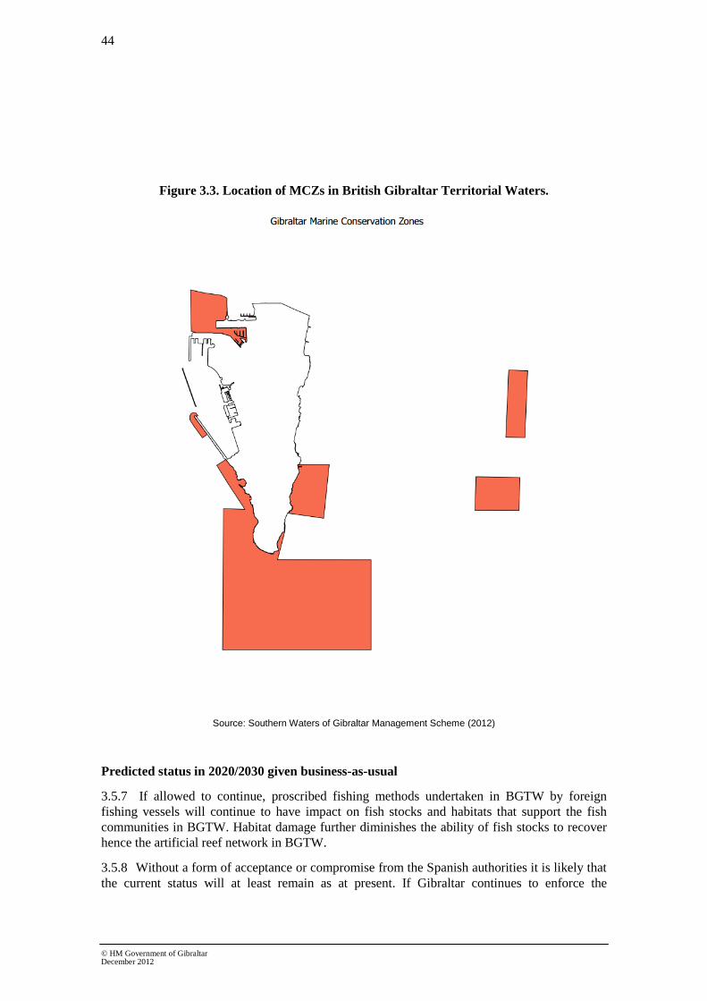
44
© HM Government of Gibraltar December 2012
Figure 3.3. Location of MCZs in British Gibraltar Territorial Waters.
Source: Southern Waters of Gibraltar Management Scheme (2012)
Predicted status in 2020/2030 given business-as-usual
3.5.7 If allowed to continue, proscribed fishing methods undertaken in BGTW by foreign
fishing vessels will continue to have impact on fish stocks and habitats that support the fish
communities in BGTW. Habitat damage further diminishes the ability of fish stocks to recover
hence the artificial reef network in BGTW.
3.5.8 Without a form of acceptance or compromise from the Spanish authorities it is likely that
the current status will at least remain as at present. If Gibraltar continues to enforce the

45
© HM Government of Gibraltar December 2012
requirements of the Nature Protection Act 1991 then the future scenario is more optimistic and
it is likely that improved fish stocks would be able to allow sustainable recreational and
subsistence fishing, and possibly a degree of controlled commercial fishing.
3.5.9 Illegal harvesting of shellfish also takes place by Spanish rake fishermen both during and
outside established shellfish harvesting seasons in Spain When the Spanish fleet is not allowed
to carry out these activities in Spanish waters they move into BGTW. This is likely to be a
continued problem since all forms of raking are prohibited in BGTW under the Nature
Protection Act 1991.
State of the evidence and development needs
3.5.10 There is limited baseline information available on the status of fish stocks in BGTW. An
initial assessment into the current status has been carried out by Tydeman & Lutchman (2013)
although further research and monitoring is required. However, it should also be noted that the
populations of pelagic fish present in BGTW are likely to be heavily influenced by fishing effort
in nearby waters and the Mediterranean in general.
3.5.11 Gibraltar has implemented no fishing areas in its own waters, however, this effort has
also been largely undone by a refusal to accept no fishing zones by Spanish fishing fleets. Until
a regional approach to fishing efforts and practices is achieved, it will be difficult to improve the
current status and future assessment of fish stocks and coastal habitats in BGTW generally.
3.5.12 With regards recreational fisheries, Gibraltar is implementing the Marine Protection
Regulations which impose conditions on this activity as well as recreational diving. It is
envisaged that this legal instrument will help Gibraltar meet the requirements of Good
Ecological Status provided that favourable developments take place in relation to illegal
commercial fishing.
Box 3.9 References used
Gibraltar Ornithological & Natural History Society (1999) Commercial Fishing and the Conservation of Marine Life in the Waters around Gibraltar
Department of the Environment. Government of Gibraltar. Southern Waters of Gibraltar Management Scheme. EU Natura 2000 Site. Dual SAC/SPA.
Zenetos, A. et al (2010) Alien species in the Mediterranean Sea by 2010. A contribution to the application of Euopean Union’s Marine Strategy Framework Directive (MSFD). Part I. Spatial distribution. Medit. Mar. Sci., 11(2), 381-493
3.6 Eutrophication (Descriptor 5)
3.6.1 Under Annex III of the MSFD the characteristics for eutrophication are described as
follows:
• human-induced eutrophication is minimised, especially adverse effects thereof,
such as losses in biodiversity, ecosystem degradation, harmful algae blooms and
oxygen deficiency in bottom waters.

46
© HM Government of Gibraltar December 2012
Current Status and trends
3.6.2 Eutrophication is the enrichment of water by nutrients, particularly due to elevated levels
of nitrogen and phosphorous. Enhanced enrichment causes accelerated growth in algae and
plants causing an imbalance of organisms present and a reduction of water quality.
3.6.3 There are limited sources that would contribute to eutrophication in BGTW, with the only
major source of additional nutrients being the point source and overflow of sewage. The River
Basin Management Plan for Gibraltar assesses coastal waters as having ‘good’ levels of
nutrients in coastal, harbour and, ground waters. However, the heavily modified water body of
Gibraltar harbour is classed as ‘probably at risk’ from sewage overflows.
3.6.4 Sewage effluent is discharged at Europa Point, at the southern end of Gibraltar, into the
coastal water body. Only screening of solids is provided as the coastal waters of Europa Point
have extremely high water exchange and high rates of natural dispersion; contaminant levels are
therefore unlikely to build up. The current risk of eutrophication is considered to be negligible.
3.6.5 Sewage effluent at Europa Point can be detrimental since it contains elevated levels of
pollutants, as do all sewage discharges that have the potential to impact on marine species and
habitats. Nevertheless sewage contains nitrogenous waste-based compounds that in dilution can
improve the nutrient content of the waters, stimulating plant plankton growth. It can also hinder
the development of marine organisms when the concentrations are excessive, but this does not
occur at Europa Point where the strong currents ensure that the effluent is quickly dispersed into
the Strait of Gibraltar. The shoreline receives a minimal quantity of nutrients in the immediate
vicinity of the outfall, and tests carried out by the Environmental Agency on the water quality of
the beaches show that the water quality complies with mandatory European standards. The use
of salt water in the flushing and sewage systems already reduces the bacteriological content and
activity of the effluent and is in effect already treating the sewage to some extent. The pumping
stations, which ensure that gravity carries the effluent to the outfall, significantly reduce the
solid waste to a mainly liquid form. However, the need to comply with the Urban Wastewater
Treatment Directive requires that a new sewage treatment plant be built and plans are already in
place for this development to be completed by 2015. Paradoxically, sewage treatment could
have the effect of reducing the food available to the fish that feed near the site, particularly
thick-lipped grey mullet Chelon labrosus, and so may have a negative effect on other species.
3.6.6 It is considered that there is good water exchange between BGTW and the wider
environment, including open sea, with the exception of the waters in Gibraltar Harbour. It is
however unlikely that there will be a build-up of nutrients or algal matter to sufficient levels to
cause eutrophication. Hypoxia is also unlikely and monitored levels of dissolved oxygen in the
coastal water body have been assessed as ‘high’ under the WFD and are predicted to remain
‘high’.
3.6.7 Under the WFD monitoring programme there are three surveillance monitoring sites in
the coastal water body and one location within the HMWB (harbour). Monitoring of nutrients
(nitrates, nitrites, ammonia and phosphates) is undertaken monthly. The current status of
dissolved inorganic nitrogen (DIN, calculated) is assessed as ‘good’ under the WFD and is
predicted to remain ‘good’.
3.6.8 It is likely that there will be some transboundary issues and features given the close
proximity of Spanish waters, in particular the heavily industrialised North area of the Bay of
Gibraltar. The location of a combined sewer overflow that services part of the neighbouring

47
© HM Government of Gibraltar December 2012
Spanish town of La Linea de la Conception and discharges directly into BGTW in the Western
Beach basin creates an additional pressure on coastal water quality.
3.6.9 Increased levels of sewage, regardless of their source, are likely to increase the risk of
eutrophication.
Predicted status in 2020/2030 given business-as-usual
3.6.10 There are no problem areas in relation to eutrophication in Gibraltar at present, however
increased pressures from human population growth and more frequent overflow events as a
result of climate change may increase future levels of nutrients in BGTW.
3.6.11 Mechanisms already in place for reducing spillages from sewer overflows include de-
silting of the gully and sewer network along with increased maintenance and upgrading of the
sewer pumping station network. A maintenance contract, overseen by the Technical Services
Department, specifies how many times a year de-silting of gullies should be undertaken.
3.6.12 In respect to the sewer network, de-silting occurs as and when required to improve
capacity. It is the responsibility of the Technical Services Department of the Government to
maintain the sewer network in good working condition. Improvements are also planned for the
network as part of the Wellington Front Flood Alleviation scheme. These improvements are
designed to reduce flooding but as a by-product will also improve the capacity of the sewers and
therefore reduce the frequency of sewer overflows into the Gibraltar Harbour.
3.6.13 Impacts of climate change are likely to affect sewage discharges, particularly overflow
events. Overall, annual rainfall levels are due to decline in the Mediterranean, however
increased storminess and greater rainfall intensity have the potential to increase the volume of
sewage disposed and the quality/chemical reactions of the sewage. Population growth within
Gibraltar in the future will also result in increased levels of sewage.
3.6.14 Continued monthly monitoring at coastal sites will monitor levels of nutrients and
negotiations with Spanish authorities will continue to attempt to resolve the impact of Spanish
sewerage on the Western Beach basin.
3.6.15 Any potential for eutrophication in 2020/2030 is predicted to decrease due to the design
and build of a new Sewage Treatment Plant. Completion is expected in 2015.
State of the evidence base and development needs
3.6.16 Considering its size, there is a relatively high number of coastal water monitoring sites
in BGTW and water quality results obtained are classified using applicable. EU water quality
standards (see Gibraltar River Basin District Management Plan for an overview of the
classification of coastal waters). There is high confidence that indicators of excessive nutrient
levels and eutrophication would be detected and that the assessment for eutrophication is
accurate.
3.6.17 A secondary sewage treatment plant has been designed and this will help further
improve the quality of sewage discharged into the coastal waters and reduce any amounts of
excess nutrients or contaminants entering coastal waters in BGTW. The design of the works will
address potential climate change effects and future population levels. The potential effect of
climate change on this point source pressure is therefore considered to be very low.
3.6.18 The use of sustainable drainage systems, where appropriate, on new developments could
help to prevent further capacity problems in the sewer network, by controlling surface water
discharges at source. Such systems can provide multiple environmental benefits not only on

48
© HM Government of Gibraltar December 2012
water quantity but on aesthetic quality and biodiversity. For example green roofs can be used to
control rainwater falling on building roofs, but also contribute toward habitat creation and
energy reduction by providing building insulation. The Gibraltar Development Plan contains a
myriad of sustainable development policies including measures that will help combat flooding
events that can potentially result in increased pollution levels. In addition, the Environmental
Agency is responsible for ensuring new developments comply with Building Regulations and
Approved Code of Practice, which includes appropriate control for the discharge of sewage, oils
and lubricants.
Box 3.10 References used
Government of Gibraltar (2011) Water Framework Directive Annual Monitoring Report 2010-2011. Produced by AMEC for the Department of Environment Gibraltar
Government of Gibraltar (2011) River Basin Management Plan, report produced by AMEC for the Department of Environment, Gibraltar
Government of Gibraltar (2011) Waste management action plan.
Perez, C.E. (2006). Biodiversity Action Plan, Gibraltar: Planning for Nature. The Gibraltar Ornithological & Natural History Society. Gibraltar.
War, S.J. 2012. A general assessment of marine pollutants in Gibraltar coastal waters (southern Iberian Peninsula) Risks and future changes. MSc dissertation thesis. University of London.
3.7 Hydrographic conditions (Descriptor 7)
3.7.1 Under Annex III of the MSFD the characteristics for hydrographic conditions are
described as follows:
• permanent alteration of hydrographical conditions does not adversely affect
marine ecosystems.
Current Status and Trends
Natural environment
3.7.2 Gibraltar forms the eastern edge of the Bay of Gibraltar. The Bay is 8km wide and
extends 10km into the mainland. It is one of the deepest bays in Europe (over 400m) and is
conditioned by the hydrodynamic movements of the Straits of Gibraltar. Estimates suggest that
there is a net surface inflow of Atlantic water through the Straits approximating 53,000 km3.
This is compensated by the export of 50,500 km3 of highly saline deep water emanating from
the Mediterranean. These mass movements of saline water through the Straits are believed to
play a key role in controlling the biogeochemistry of the Mediterranean and even the circulation
and climate of the Atlantic Ocean.
3.7.3 The bathymetry surrounding Gibraltar is varied. On the West coast there is a narrow shelf
area and steep continental slope with deep water (>200m) within a mile of the shoreline. In the
centre of Gibraltar Bay the water depth reaches around 400m. To the South, the coastal slope
separating Gibraltar from Morocco declines to around 900m within 10 miles of the coast.
BGTW extend up to 3 nautical miles from the southern and eastern shores and up to the median
line in the Bay of Gibraltar, and therefore there are limited deep sea environments in BGTW.

49
© HM Government of Gibraltar December 2012
3.7.4 To the East there are shallow coastal habitats predominantly characterised by sandy/soft
substrates and reef. This extends out for several km up to the continental slope where both
maerl and rock are found along the outer edges of BGTW.
3.7.5 Salinity levels within BGTW (1 mile out) generally lie within the Euhaline range (30 to
<40 ppt). Due to the high variability of depth, with areas of deep and shallow water, mean depth
would equate more closely to the intermediate type. The coastal water type therefore can be
considered as Mediterranean euhaline intermediate.
3.7.6 The natural intertidal zone is a mix of rocky shore, manmade structures and sandy
beaches, with most of the shore being rocky shore. However, due to the lack of tidal movement
in the Mediterranean (approximately 1 m vertical movement), the intertidal zone is relatively
narrow and somewhat compressed.
3.7.7 Within the stable bi-directional currents moving into and out of the Straits of Gibraltar lie
smaller-scale superficial currents that operate within the Bay of Gibraltar itself. Prevailing
currents tend to be either easterly or westerly in line with dominant wind patterns observed in
the Straits area. The exact direction of the current ultimately depends on the state of the tidal
cycle although winds can amplify, cancel and even reverse tidal currents within the Bay.
Figure 3.4 Main current flows in the Bay of Gibraltar during (a) tidal flux and (b) tidal reflux.
Source: Fa 1998. Modified from Caminas, 1987.
3.7.8 The Alboran Sea, situated immediately East of Gibraltar, exhibits strong Atlantic
affinities with the incoming influx of water. The incoming Atlantic waters form a permanent
clockwise gyre in the Alboran Sea, which is separated from the rest of the western
Mediterranean by a well-marked hydrographic front.
3.7.9 There are no rivers in Gibraltar. Two major rivers enter the Bay in Spanish waters, the
Rivers Palmones and Guadarranque, creating localised salinity gradients within the Bay.

50
© HM Government of Gibraltar December 2012
Key Pressures
3.7.10 Gibraltar has an overall size of 6.8 km2
and a coastline of 12km and a high population
density of 4,959 people per km2. As such, it has a high proportion of coastal development, much
of which is residential and light industrial. The western coast is heavily developed with a large
amount of the coast dedicated to harbour facilities and marinas. There are also heavily
developed residential and tourist areas along this coast. The East side is less densely developed
with mainly residential, tourist, leisure developments and bathing beaches along the coast.
3.7.11 Gibraltar Harbour has a large seawall enclosing a body of water and reclaimed land.
There are also large, manmade moles creating an irregular shoreline within the harbour water
body. The East side is still largely composed of a natural rocky shoreline with the exception of
the new reclamation found within the North-east part of BGTW. Developments that extend into
the coastal zone can alter hydrodynamic and sedimentary processes in the coastal waters.
Activities likely to cause an impact on coastal processes are:
• Dredging altering sedimentation, water circulation and tidal flows;
• Coastal development such as harbours, sea defences and shoreline developments
altering patterns of water movement and as a consequence patterns of erosion and
deposition;
• Reclamation of land;
• Discharge of water into coastal areas from industrial and sewage processes; and
• Seawalls and rock armour that prevent waves dissipating energy through erosion
and breaking, and reflect energy back to sea. This can cause greater turbulence in
adjacent sand and mud and/or reduce sediment supply to adjacent habitats.
3.7.12 Gibraltar Harbour consists of a large seawall restricting the flow between Gibraltar Bay
and the inner harbour waters.
3.7.13 As part of the pressure and impact analysis, provisional HMWBs can be identified. If a
water body is at risk or probably at risk of failing to meet good ecological status as a result of
morphological pressures, it is provisionally identified as a HMWB. The Gibraltar Harbour
coastal area and area between the harbour and the airport have been provisionally designated as
a HMWB in the Gibraltar River Basin District Management Plan.
3.7.14 The restricted flow and exchange between the open sea and the harbour area due to the
large sea wall and restricted access cause considerable hydrodynamic and sedimentation
impacts. It is also likely to trap contaminants in the harbour basin and increase contamination
levels.
3.7.15 In other regions of Gibraltar coastal development is unlikely to have major impacts on
hydrographic conditions, although manmade protrusions into the intertidal area along the coast
(such as beach defences and jetties) are likely to have small scale localised impacts on coastal
processes.
3.7.16 Dredging around the harbour channel is likely to alter sedimentation and hydrodynamic
processes around the harbour coastal water and HMWB area.
3.7.17 Dredging is an invasive procedure that causes direct and indirect losses of sediment due
to removal and alterations in sediment transport regimes. It also directly impacts on faunal

51
© HM Government of Gibraltar December 2012
habitats through habitat loss and alteration. There is also the potential for dredging to re-suspend
contaminants trapped in sediments and create significant sediment plumes which result in
smothering of adjacent benthic habitats. However, in the longer term, removal of contaminated
sediment can prove beneficial to faunal habitats. Additionally, the development of beach
groynes, especially if made from limestone, provides opportunities for new communities to
develop.
3.7.18 As Gibraltar is highly restricted by size and already has a high population density it is
likely that creating reclaimed land in the coastal area will continue as a result of economic
development. This will increase pressures on hydrodynamic and sediment processes in both the
Gibraltar Harbour HMWB and coastal water body.
Environmental impact from alterations to hydrodynamic regimes
3.7.19 Much of Gibraltar’s near shore benthic habitat is sandy substrate, however, there are
areas of coastal rocky reef, artificial reef and maerl beds which are particularly high in
biodiversity and are important biological habitats.
3.7.20 Due to the proximity of the deep waters of the Strait and the mixing of Mediterranean
and Atlantic waters there are also important pelagic fish communities found in the waters
surrounding Gibraltar. These include highly important species (both from a commercial and
conservational perspective) as previously outlined as part of the fisheries descriptor.
3.7.21 In the current status, coastal developments are shore based with some projects extending
into the intertidal and near shore area. These structures are unlikely to alter or impact on the
large scale currents acting within Bay of Gibraltar and beyond.
3.7.22 However, these coastal developments do alter the natural shape of the coastline and are
likely to have localised impacts on tidal movements along the shoreline, potentially impacting
on sediment transportation and erosion in the intertidal/near shore zone.
3.7.23 Within the modified water body of the harbour the intertidal zone and marine life has
been greatly compromised by the reclamation of land around the moles. Water exchange has
been restricted by the sealing of a channel that allowed water exchange between open water in
Bay of Gibraltar and the harbour. The present currents are sometimes insufficient to allow
sufficient hydrodynamic movement in the harbour. Coupled with the low tidal range, this can
potentially result in a degree of stagnation of the harbour waters at certain times of the year
which is then likely to affect marine life within this Harbour.
3.7.24 It is also likely that the lack of water movement within the harbour area will result in
sedimentation which will then have to be regularly dredged to maintain the necessary depth.
Sedimentation, most likely with a degree of contamination, will also negatively impact marine
fauna in the harbour area. It is likely that poor water exchange will contain and increase the
levels of contamination in the harbour area and reduce levels of biodiversity within the water
body.
3.7.25 Dredging activities around the harbour are also likely to increase suspended sediment
levels and smothering of the surrounding environment, although smothering outside of the
harbour will be reduced due to the good levels of water exchange.

52
© HM Government of Gibraltar December 2012
3.7.26 Saltwater intakes for Gibraltar’s reverse osmosis are also located within the harbour
although the outfalls are located in the coastal water body. Reverse osmosis plants can result in
localised salinity and temperature gradients which will impact on the zonation patterns of local
biological communities, reducing biodiversity.
3.7.27 Similarly, the sewage outfall at Europa Point is likely to have impacts on the local
biological and physio-chemical condition by creating localised plumes of warmer and low
salinity water with higher nutrient levels. The impacts from this will be minimised following
construction of the new secondary sewage treatment plant in addition to the high degree of
hydrodynamic movement that is characteristic of Europa Point.
Predicted Status by 2020/2030
3.7.28 The existing marine planning, licensing and consent process will ensure that
developments are assessed, and potential impacts on hydromorphological conditions are
appropriately managed and monitored, in line with the requirements of the EU Environmental
Impact Assessment Directive and the EU Habitats and Birds Directives.
3.7.29 It is important to understand how changes in hydrographical conditions as a result of
human developments interact with the potential shifts in hydrographic conditions due to
changing climate and increased levels of atmospheric CO2. For example, temperatures in the
North Atlantic have risen by around 1°C since 1910 and similar rises in Mediterranean waters
may have impacts on water mixing and hydrodynamic processes as predicted by the
Intergovernmental Panel on Climate Change.
3.7.30 Gibraltar has an increasing population and is trying to attract both industry and tourism.
Given its limited space for expansion it is likely that the need for more reclaimed land is going
to be greater over the next decade. Hydrological impacts will need to be carefully assessed both
individually and cumulatively to determine the impacts and extent of any changes to sediment
transport or hydrological regimes.
State of evidence base and development needs
3.7.31 Much of the evidence has come from monitoring carried out under the WFD, focusing
on water bodies. Several other studies into pollution and the biodiversity action plan have
looked at hydrological regimes and conditions around the coast.
3.7.32 Halcrow (2007) conducted an extensive EIA process for the Eastside development. This
included surveying hydrodynamic and sedimentation regimes. The level of surveying provided a
great deal of useful information but was restricted in scope to the development area. Similar
information for the entire coastline area is currently being obtained and this will be useful in
providing further information on localised currents, and sediment transport regimes. This
information will be beneficial to inform any required impact assessments of future coastal
developments.
3.7.33 Information of this nature is important when assessing the wider environment and
attempting to consider widescale and cumulative impacts.
3.7.34 The Gibraltar Port Authority undertakes regular depth studies to review the impacts of
and needs for dredging within the Harbour. Consultation with the Department of the
Environment will ensure that any required dredging operations do not impact on sensitive or
protected habitats outside the Harbour.

53
© HM Government of Gibraltar December 2012
Box 3.11 References used
Casier, R. (2011) Marine Protected Areas in the Mediterranean Sea, study awarded by EUROPARC Conference 2011 and made possible by Alfred Toepfer Stiftung F.V.S DoE, Gibraltar & Environmental Agency, Gibraltar (2008) Climate Change: The Gibraltar Programme
Cebrián, E., and Ballesteros, E. Zonation patterns of benthic communities in an upwelling area from the western Mediterranean (La Herradura, Alboran Sea), Scientia Marina, 68(1), 69-84
Doe, Gibraltar. Guidelines for the Assessment of Dredged Material
Fa, D.A. and Finlayson, G. (2008) Marine Surveillance – Diving and Intertidal Survey, final report prepared by The Gibraltar Museum for The Ministry of Environment
Government of Gibraltar. Southern Waters of Gibraltar Management Scheme. EU Natura 2000 Site. Dual SAC/SPA.
Government of Gibraltar (2011) River Basin Management Plan, report produced by AMEC for the Department of Environment, Gibraltar
Halcrow (2007) Eastside Environmental Statement
Sarhan, T. et al (2000) Upwelling mechanisms in the northwestern Alboran Sea, Journal of Marine Systems, 23, 317-331
Warr, S.J. (2012) A general assessment of marine pollutants in Gibraltar coastal waters (southern Iberian Peninsula) Risks and future challenges, MSc Thesis., University of London. Unpubl.
3.8 Contaminants (Descriptor 8 and 9)
3.8.1 Under Annex III of the MSFD the characteristics for contaminants are described as
follows:
• concentrations of contaminants are at levels not giving rise to pollution effects;
and
• contaminants in fish and other seafood for human consumption do not exceed
levels established by Community legislation or other relevant standards.
Hazardous substances
Current Status and Trends
3.8.2 Sediment and water quality monitoring in Gibraltar is undertaken as part of the River
Basin Management Plan. Recent results from sediment analyses show that the levels of
contamination vary between sites, with the Harbour area showing signs of elevated contaminant
levels.
3.8.3 Under the WFD monitoring programme there are three surveillance monitoring sites in
the coastal water body and one location within the HMWB (harbour). Monitoring of priority
substances and specific pollutants in the water column occurs on a quarterly basis and in
sediments on a monthly basis.
3.8.4 The state of the Coastal Water body and Heavily Modified Water Body (HMWB) of
Gibraltar Harbour were assessed as part of the River Basin Management Plan in 2011. The
coastal water body was classified as attaining ‘Good Ecological and Chemical Status’.

54
© HM Government of Gibraltar December 2012
3.8.5 The HMWB was assessed as having Good Ecological Potential but a Chemical Status
Fail was reported due to elevated levels of di- and tri-butyl tin (DBT and TBT). Heavy metals
(including DBT and TBT) are harmful to marine organisms and accumulate throughout the food
chain. Higher trophic species accumulate greater levels of contaminants and this can affect the
quality of fish and shellfish for human consumption. The regular consumption of contaminated
food can lead to poisoning in humans.
3.8.6 DBT and TBT were commonly used in anti-fouling paint to protect ships hulls from
colonising organisms. The use of both was banned in 2008 due to their environmentally harmful
effects but levels still remain high in many harbour areas due to the long lived nature of the
contaminant which is a biocide. Ships painted before 2008 are likely to still have DBT/TBT
containing paint on their hulls and as such are likely to continue to release pollutants into the
marine environment.
3.8.7 Levels of TBT and DBT in both the water column and sediment were elevated within the
harbour particularly the Harbour South sampling site. The harbour contains an operational
shipyard and dockyard, which was formerly the Royal Navy dockyard, built at the end of the
19th century before being acquired by successive private companies. The dockyard was in
operation when TBT was used as an anti-fouling paint on vessels.
3.8.8 Gibraltar has a low amount of industry, with virtually no heavy industry. There are
therefore relatively few sources of land based hazardous waste that are likely to enter the coastal
area except through the sewerage system or marine pathways.
Biological effects of heavy metal contamination
3.8.9 As part of Gibraltar’s water quality assessment the condition of phytoplankton and
macro-benthic invertebrates were monitored in order to assess the ecological quality of
Gibraltarian water bodies. Both water bodies were assessed as having Good Ecological Status
(or potential).
3.8.10 The main biological effect identified as part of monitoring is the elevated levels of TBT
seen in Gibraltar Harbour waters causing it to fail the Chemical Status criterion. TBT is ingested
by benthic fauna and accumulates in species that predate on them, it also causes growth
abnormalities and hermaphroditic deformities in some benthic invertebrate species exposed to
high levels.
3.8.11 Although there are areas of elevated contaminant levels within BGTW, the wider
marine area has been assessed as having both Good Ecological and Good Chemical Status.
Predicted biological effects of hazardous substances are therefore considered to be minimal
although research in this field is still being carried out. It is worth noting that studies carried out
on cetaceans in the Bay and Straits of Gibraltar, specifically Delphinidae, have shown that the
levels of some contaminants are higher than neighbouring Atlantic populations. It is believed
that the elevated concentration of contaminants in tissue samples are attributed to industrial
activities in the Bay and the intense shipping activity that is characteristic of the Straits of
Gibraltar.
3.8.12 With respect to GES Descriptor 9, monitoring of fish and other seafood for human
consumption is based on the requirements laid out in Commission Regulation 1881/2006.
Analytical tests of fish and seafood for retail in Gibraltar are carried out by the Environmental
Agency. These surveys indicate that contaminant levels in fish and seafood rarely exceed

55
© HM Government of Gibraltar December 2012
maximum levels specified in the legislation. However some consumers e.g. children and
pregnant women are advised to avoid eating certain species such as tuna, marlin and swordfish
due to their elevated mercury content.
3.8.13 Due to the size of BGTW there is limited scope for commercial fishing. Gibraltar
predominantly imports its fish and fish tissue samples are regularly sent to the UK for testing by
the Environmental Agency.
Predicted Status in 2020/2030 given business as usual
3.8.14 The effective implementation of the Urban Waste Water Treatment Directive, the WFD,
the Integrated Pollution Prevention and Control Directive, and the European Community
Regulation on chemicals and their safe use (REACH) (EC 1907/2006) is likely to ensure
progress towards Good Chemical Status (for priority and priority hazardous substances) and
contribute to Good Ecological Status (for other pollutants) for some problem areas up to 2020,
with further improvements likely up to 2030. However, there are likely to be some areas where
the measures taken to control inputs of contaminants may not be sufficient to minimise impacts
due to the presence of persistent contaminants in sediments where it will not be practicable to
take remedial measures. In addition, the discharge of hazardous substances outside of BGTW
within the Bay of Gibraltar could also affect the future chemical status of BGTW.
3.8.15 Under the WFD, future monitoring in coastal waters will potentially encompass a wider
range of substances. WFD environmental quality standards adopted in Directive 2008/105/EC
provide an enhanced level of environmental protection and these are being applied in BGTW.
State of the evidence base and development needs
3.8.16 The evidence is based on water quality monitoring and sediment contaminant
monitoring in line with the WFD in order to assess the quality of coastal waters in terms of
chemical and ecological status. The monitoring has been conducted in both Gibraltar Harbour
and the surrounding coastal area comprising BGTW. Bacterial levels of coastal water are also
regularly monitored in line with the requirements of the revised Bathing Water Directive so as
to adequately assess the quality of water in bathing areas.
Further contaminant analyses on fish and other marine organisms would be beneficial and are
being incorporated into existing monitoring programmes to further assess the risks of
contamination in specific marine organisms and the likelihood of bioaccumulation from long
term contaminants such as heavy metals and organotins.
Oil contamination
Current Status and Trends
3.8.17 Oil pollution is often a major environmental consideration in areas with high levels of
human coastal activity. Areas with high levels of vessel activity are particularly at risk from oil
pollution from day to day activities. Vessels use various forms of oil based substances from fuel
and hydrodynamic fluids to cleaning products, all of which have the potential to enter the
coastal waters. It is a regular occurrence for vessels to emit some form of minor oil discharge in
ballast or waste water whilst in transit.
3.8.18 Within the Port of Gibraltar bunkering and associated shipping activities are some of the
most frequent activities. Bunkering activities also take place in the opposite side of the Bay of
Gibraltar in Spanish Territorial Waters. Most bunkering activities that take place in BGTW are

56
© HM Government of Gibraltar December 2012
via ship-to-ship transfer and the Gibraltar Port Authority operates a strict bunkering code of
practice and enforcement programme to ensure that there are no accidental discharges to the
marine environment. Amongst the precautionary measures implemented, each Bunkering
Operator and the Gibraltar Port Authority maintain equipment and personnel on 24 hour standby
in the unlikely event that a ‘Tier 1’ incident occurs (small spill size which varies depending on
circumstances but could be up to 500 litres). In addition, an ad-hoc inspection programme is in
place to ensure that the bunkering code of practice is adhered to. To date, there has been no
major oil spills reported in BGTW as a result of bunkering operations, however, small spills are
reported several times a year on opposite sides of the Bay as a result of the intense maritime
activity.
3.8.19 An oil refinery and other large industrial facilities are located in the northern part of the
Bay in Spain. These installations all have discharges into the marine environment and are very
likely to be causing an impact on water quality in the Bay of Gibraltar. Results obtained through
the WFD monitoring programme will continue to help assess the impact of all known
contaminant sources within and outside of BGTW.
Biological effects of oil pollution
3.8.20 Oil contamination is one of the major forms of worldwide coastal pollution causing both
long and short term impacts on marine fauna and flora.
3.8.21 Short term impacts include the smothering and physical impairment of flora and fauna
and the toxic effects caused by absorption or ingestion of oil. Longer term impacts occur when
contamination, whilst not acutely toxic, impact on mortality and biological community structure
and also the chemical and physical alteration of habitats due to the incorporation of oil
contaminants.
3.8.22 Different types of oil based substances have different impacts, lighter oils tend to be
more toxic but more easily dispersed than heavier oils which are less toxic but longer lived.
Smothering is more indicative of a heavy or crude oil spill.
3.8.23 Surface slicks do not tend to remain intact for long periods as wind and wave actions
tend to break slicks up and disperse pollutants. However, whilst it is in the form of a slick it can
cause considerable damage to seabirds using the area by oiling their feathers and reducing their
ability to feed and fly effectively.
3.8.24 Shoreline communities tend to be the most heavily impacted by oil slicks near coastal
areas as the oil washes up on shore and does not break down as easily. It also becomes heavily
incorporated into coastal sediments. Coastal areas tend to have the highest biodiversity and, this
can lead to high levels of mortality at all trophic levels due to smothering and toxicity.
3.8.25 Once oil disperses into the environment it becomes less dangerous from a short-term
stance, it is less toxic and less likely to oil bird feathers. Once it is has dispersed, toxins then
begin to accumulate in the water and sediments over a wider area and can raise background
contaminant levels. This may then impact a larger number of species as they accumulate the
toxins within themselves through long term ingestion and exposure.
3.8.26 In Gibraltar the main risk to the biological community is from fuel oil spills. These are
likely to be small and surface based. With the spill response facilities in place, the spills are
likely to be short lived and therefore the main dangers to the environment are likely to be to
birds and surface dwelling organisms.

57
© HM Government of Gibraltar December 2012
3.8.27 Contaminant analysis shows that in some areas hydrocarbon contaminants are elevated
in coastal sediments. This could potentially have long term impacts on the structure of benthic
communities.
Predicted Status by 2020/2030 given business as usual
3.8.28 Gibraltar is becoming an increasingly important refuelling station for ships passing
between the Atlantic and the Mediterranean. Due to the size of Gibraltar harbour and the
number of vessels seeking bunkering services much of the activity takes place in the form of
ship-to-ship transfer in line with the strict conditions imposed by local authorities.
3.8.29 There are inherent risks to the environment from any form of refuelling activities
whether based on land or sea. In order to maintain the current level, it is important that the risk
of minor oil spills from bunkering exercises is continuously assessed and the required measures
implemented.
3.8.30 Due to the amount of vessel traffic in and around Gibraltar and the accumulating nature
of contaminants, it will be difficult to maintain current levels of contamination, particularly in
the heavily modified water bodies where water exchange is restricted.
3.8.31 The Gibraltar Port Authority has an Oil Spill Response Plan and is an Associate
Member of Oil Spill Response Ltd which is based in Southampton. Oil spill response
procedures are therefore in place to quickly deal with any minor oil spills should they occur
within or outside BGTW in High Seas.
3.8.32 Run-off from roads and hard surfaced areas are also a likely input of oil contamination
into the marine waters. This is currently being controlled using trapped gullies intercepting most
fuel, oil and heavier contaminants running off from all main roads. The likelihood of oil
contaminants from road run-off reaching the sea is predicted to fall in the future with the
installation of additional oil interceptors in both major and minor storm drains.
3.8.33 Given the likelihood and known risks of transboundary pollution, Gibraltar will find it
difficult to maintain or improve background levels without the cooperation of neighbouring
countries.
State of the evidence and development needs
3.8.34 Sediment and water quality monitoring and analysis have been undertaken at numerous
sites in BGTW providing baseline information on specific contaminant levels.
3.8.35 Continued monitoring and a reduction in the level of contaminants entering the marine
environment will be required to maintain or improve on current levels. Regional cooperation
and exchange of information is also critical to the success of improving the status of BGTW.
3.8.36 Continued surveillance and reporting of any minor oil spills within and outside of
BGTW should continue so as to identify additional measures that could be implemented and
help safeguard marine habitats and species.
Radio-nucleotides
Current Status and Trends
3.8.37 Environmental radiation is a concern because of its wide ranging and negative impacts
on both the environment and humans. Major incidents are an obvious source of radioactive
pollution; however, less obvious is the accumulation of smaller levels of radioactive material
through the marine food chain.

58
© HM Government of Gibraltar December 2012
3.8.38 Radioactive pollution tends to be long lived and some elements take hundreds of years
to become neutral. Therefore, there is a high potential for levels of radioactive substances to
accumulate through the marine food chain into the higher life forms such as fish and seabirds.
Some of these species then become food for human consumption.
3.8.39 There are no major sources of radioactive pollution in Gibraltar or BGTW. Continued
monitoring is undertaken by the Environmental Agency on desalinated potable drinking water in
line with Directive 98/83/EC (Drinking Water Directive). Additional monitoring is carried out
on coastal water and sediments and levels recorded to date have been found to be below EU safe
limits for all elements tested.
Biological Effects of Radio-nucleotides
3.8.40 Radio-nucleotides are long lived contaminants and as such there is the potential for bio-
accumulation to occur, even at low levels of contamination.
3.8.41 Radio-active particles naturally occur in the Earth’s crust and natural background levels
of radiation are often recorded and not environmentally damaging. Additional contamination
from anthropogenic sources can add to the background levels of radiation, these can have more
detrimental impacts if present in high concentrations. Fallout from various sources such as
Pacific Island weapons testing, Chernobyl and Fukushima can be found in low levels across the
globe, spread by atmospheric conditions.
3.8.42 Radioactive particles can enter the food chain through contaminated sediment which is
ingested by benthic organisms. These are in turn eaten by higher trophic species. Low levels of
radioactive particles in base organisms can accumulate in higher species through predation. This
may culminate in species for human consumption having relatively high levels of radiation,
which is then passed on to human consumers.
3.8.43 The accumulation of high levels of radiation has the potential to impact species on a
cellular level, increasing the risk of cancers and growth defects and increasing mortality.
Widespread contamination is likely to spread through a food web and have significant impacts
on biological communities.
3.8.44 Due to various nuclear episodes and activities, low levels of contamination are globally
widespread. The levels of radiation in Gibraltar are lower than many other European coastal
countries and it is unlikely that the biological communities around Gibraltar are particularly
affected.
Predicted Status by 2020/2030 given business as usual
3.8.45 It is anticipated that the levels of radioactive contamination will remain the same and
not significantly increase. Gibraltar itself has no sources of radioactive pollution and has a
limited capacity to prevent radioactive pollution from other areas.
3.8.46 Gibraltar will continue to monitor the levels of radio-active contamination in its waters.
State of the evidence and development needs
3.8.47 Water sampling for radio-nucleotides is conducted in two areas from around Gibraltar.
An increased sediment and coastal water sampling strategy may prove beneficial to improve
spatial coverage. However, with no evidence of elevated radiation levels, additional monitoring
is not deemed necessary.
59
© HM Government of Gibraltar December 2012
Microbial Contamination
Current Status and Trends
3.8.48 Key monitoring priorities for microbial contamination include monitoring the
concentrations of total coliforms, faecal coliforms and e-coli. These microbes tend to be present
in areas where there is untreated sewage input causing poor water quality. These contaminants
can cause illness through coastal users being exposed to poor quality bathing water and also
have the potential to contaminate food resources.
3.8.49 Gibraltar has six main bathing areas and these are all monitored in accordance to EC
Directives 76/160/EC and 2006/7/EC. Five of the beaches have quality results for total
coliforms, e-coli and faecal streptococcus that are consistently below the mandatory EC
standards and only occasionally failing the EC Guideline values.
3.8.50 The Western Beach bathing area failed the minimum EC mandatory levels for total
coliforms and e-coli and UK guidelines for faecal streptococcus through most of January to May
and October to December 2012. These poor quality results are attributed to input of untreated
sewage from an overflow located in mainland Spain.
3.8.51 The coastal waters around Gibraltar have ample hydrodynamic exchange with the wider
Mediterranean and microbial contamination is therefore quickly dispersed in most areas with the
exception of the Gibraltar harbour, Northern marina and Western Beach basins. During periods
of prolonged heavy rain, overflows may occur on the main sewer network which can result in
rainwater, surface/road run-off and sewage discharging at various points along the coast and
within the Harbour and Marina Bay. Individually these sources may not cause a significant
pressure on the environment, but collectively the diffuse pressure could be significant.
Biological Effects of microbial contamination
3.8.52 The major concern over the microbial quality of bathing water is public health. Bathing
in water contaminated by coliforms and faecal matter can cause serious illnesses in humans and
it is a priority concern within the EU and UK. Mandatory and guideline levels for microbial
contaminants are stipulated by the EU in the Bathing Water Directives (Directives 76/160/EC &
2006/7/EC). For public safety reasons, designated bathing waters must be regularly tested and
have sufficient quality levels to be announced as safe for bathers. The Gibraltar Bathing Waters
Programme is spearheaded by the Environmental Agency and the results collected to date are
available from http://www.environmental-agency.gi/environmental_monitoring.htm.
3.8.53 The release of high levels of bacteria into the water has the potential to impact on fish
and shellfish species in affected areas. Bacteria such as e-coli are consumed by fish and shellfish
along with the organic matter from raw sewage; these bacteria are then consumed by humans
causing illness.
3.8.54 As well as the impact on human populations, exposure to bacteria can increase infection
and mortality in exposed fish and shellfish species.
Predicted Status by 2020/2030 given business as usual
3.8.55 The number of instances where water quality has failed to meet the EU Guideline level
has increased year on year since 2009. Prior to this beaches consistently met both mandatory
and guideline levels. Without investigation it is a concern that levels will continue to worsen.
During 2011 and 2012 the number of instances where Western Beach did not meet mandatory
guidelines also increased.

60
© HM Government of Gibraltar December 2012
3.8.56 In addition to the known discharges of sewage effluent within BGTW, it is likely that
significant levels of pollution are entering BGTW from adjacent Spanish waters on both western
and eastern sides of BGTW. The sewage outflow near Western Beach is evidence of this along
with the infrequent closures of bathing areas in La Linea (Spain) as a result of the numerous
storm overflows and a sewage outflow located immediately North of BGTW. There are
concerns that transboundary microbial pollution originating from Spain may continue to impact
BGTW in the foreseeable future. It is likely that Spanish sources are the cause of the increases
referred to in 3.8.55.
3.8.57 Negotiations have taken place with local authorities in Spain with regards to the
untreated sewage outfall at Western Beach but the issue is currently unresolved.
3.8.58 As the population of Gibraltar and number of tourist visitors grows, increasing pressure
is likely to be placed on sewerage and treatment facilities which have the potential to increase
the levels of contaminants in the coastal area.
3.8.59 Increased rainfall intensity due to climate change has the potential to increase the
amount of untreated sewage entering the coastal zone through overflowing.
State of the evidence and development needs
3.8.60 Investigations are being carried out to determine the reasons for the observed
deterioration in water quality since 2009. It is known that Western Beach is continually having
problems with untreated sewage from Spain, but given that other beaches, particularly on the
eastside are increasingly failing the Guideline levels, further investigations are currently being
carried out by both the Department of the Environment and the Environmental Agency.
3.8.61 Monitoring of bathing water quality has good spatial coverage and is carried out
regularly in compliance with the Bathing Water Directives. There is a good historical data set
for bathing water quality, all of which is reported to the Commission.
3.8.62 The fact that elevated levels may have transboundary sources will require regional
cooperation to ensure that the objectives of the MSFD and other water quality directives are
met. Continuous improvements of the sewer network and the development of the new secondary
sewage treatment plant will ensure that there are no untreated sewage effluents being discharged
into BGTW.
Box 3.12 References used
Gibraltar Port Authority http://www.gibraltarport.com/, (accessed 20/12/12)
Government of Gibraltar (2011) Gibraltar Waste Management Plan, prepared by the Environmental Agency Gibraltar in conjunction with the Department of the Environment
Government of Gibraltar. Southern Waters of Gibraltar Management Scheme. EU Natura 2000 Site. Dual SAC/SPA.
Government of Gibraltar (2011) River Basin Management Plan, report produced by AMEC for the Department of Environment, Gibraltar
Halcrow (2007) Eastside Environmental Statement
http://jncc.defra.gov.uk (accessed 13/12/2012)
Perez, C.E. (2006) Biodiversity Action Plan, Gibraltar: Planning for Nature, The Gibraltar Ornithological & Natural History Society, Gibraltar
Shaw, E. (1996) The Gibraltar Artificial Reef: Habitat Manipulation. Almoraima. 15: 197-204.
Warr, S.J. (2012) A general assessment of marine pollutants in Gibraltar coastal waters (southern Iberian Peninsula)

61
© HM Government of Gibraltar December 2012
Risks and future challenges, MSc Thesis, University of London.
Wildlife (Gibraltar) Ltd (2007) Six-year report for the EC Habitats Directive 2000-2006: Gibraltar, report for the Government of Gibraltar
3.9 Litter (Descriptor 10)
3.9.1 Under Annex III of the MSFD the characteristics for marine litter are described as
follows:
• properties and quantities of marine litter do not cause harm to the coastal and
marine environment.
Current Status and Trends
3.9.2 The UK MSFD Initial Assessment describes marine litter as follows: any persistent,
manufactured or processed solid material discarded, disposed of, abandoned or lost in the
marine and coastal environment can be defined as marine litter.
3.9.3 Much of the litter that enters the marine environment consists of long lived materials,
such as plastic, that degrade slowly, if at all. If the input of litter into the environment is
constant, a gradual build-up of litter will occur.
3.9.4 Litter enters the marine environment from various sources: ships, fishing and offshore
industries are a common source of litter, as too is litter left by beach users in the coastal area.
3.9.5 Gibraltar faces potential problems with litter and waste; the restricted size of Gibraltar
limits the amount of space that can be set aside for waste disposal facilities. Many of the
facilities found in other countries are not possible in Gibraltar due to its limited size, and
because of economies of scale. The high population density and the large number of visitors to
Gibraltar each year also exacerbate litter and waste disposal problems.
3.9.6 There is also a major issue due to the volume of products that are imported into Gibraltar.
These items, both domestic and industrial, inevitably result in a large volume of packing
materials that subsequently need to be disposed, adding additional pressures on the waste
facilities.
3.9.7 Europa foreshore, located in the Southern Waters of Gibraltar has been used by anglers
for many years. This has led to a problem of littering on occasions, and there has been an
observed impact on the intertidal community.
3.9.8 The Governor’s Cottage and Hole in the Wall areas of the Southern District are described
as having high levels of litter (of various types) deposited on and near the cliffs in these areas.
This is likely to increase levels of marine pollution in these areas as some of the debris is likely
to eventually end up in the sea.
3.9.9 Gibraltar has an important tourist industry, its beaches are an essential element of that
industry. As noted in the UK MSFD Initial Assessment, tourism and beach users are one of the
main sources of marine litter and it is likely to be an important source of marine litter in
Gibraltar.

62
© HM Government of Gibraltar December 2012
3.9.10 The full extent of marine litter in BGTW is currently being investigated with the
majority of information collected to date being restricted to the Gibraltar harbour, main beaches
and near shore coastal areas. Formal investigations and monitoring implemented (see 3.9.18)
in line with the requirements of the MSFD, will help assess the issue of marine litter in all its
forms, i.e. flotsam, jetsam and intertidal litter.
Key Pressures
3.9.11 Litter places a physical risk to marine life through entanglement and ingestion. In
particular, marine mammals, birds and turtles are at risk. If there is a particularly high level of
litter, there can be smothering effects on marine habitats associated with marine litter.
3.9.12 There is also concern that levels of harmful contaminants may start to enter the food
chain. As plastics begin to physically wear and degrade, it is possible that particles will become
small enough to be readily ingested by important food web species. The concern is that these
plastic contaminants may accumulate through the food web and impact higher trophic species
and the quality of commercial fish species.
3.9.13 The main sources of marine litter in the Mediterranean are cited as being from:
• Illegal disposal;
• tourist facilities;
• run-off from waste installations/facilities;
• run-off from rivers;
• pleasure crafts;
• direct disposal from urbanised areas; and
• ships.
3.9.14 Gibraltar does not have any litter input from river run-off or direct disposal; however,
all the other sources are likely to contribute to marine litter in BGTW. It should also be noted
that litter from adjacent waters and beyond is known to migrate into BGTW. Increasing levels of
shipping, tourists using the beaches and coastal developments in the Bay of Gibraltar generally are
likely to be the greatest sources of marine litter in BGTW.
3.9.15 Litter in the beach area is a particular problem because not only does the litter damage
intertidal and coastal habitats, it also has economic implications from a tourism perspective.
3.9.16 Although an efficient cleansing programme is in operation throughout the coastline of
BGTW, regular cleanup and awareness raising events are additionally carried out by non-
governmental organisations (NGOs) that regularly participate in the global ‘Clean up the World
Campaign’. Examples of past campaigns can be found on http://www.esg-gib.net/clean-up-the-
world/. In addition, the Gibraltar Government’s Litter Committee ensures that all reports of both
marine and coastal litter are highlighted and the necessary remedial actions taken.
Development needs
3.9.17 There is a comprehensive Waste Management Plan in place in Gibraltar which details
how the numerous waste streams generated are managed. This plan includes waste streams
emanating from shipping and any other activities that could pose a risk to the marine
environment.

63
© HM Government of Gibraltar December 2012
3.9.18 Surveys and continued monitoring undertaken by the Department of the Environment,
Gibraltar Port Authority, Environmental Agency, Gibraltar Tourist Board and NGOs will help
to quantify and characterise marine litter in BGTW. This information will be used to establish
future trends in marine litter as the knowledge base expands.
Box 3.13 References used
Government of Gibraltar. Southern Waters of Gibraltar Management Scheme. EU Natura 2000 Site. Dual SAC/SPA.
Government of Gibraltar (2011) Gibraltar Waste Management Plan, prepared by the Environmental Agency Gibraltar in conjunction with the Department of the Environment
Perez, C.E. (2006) Biodiversity Action Plan, Gibraltar: Planning for Nature, The Gibraltar Ornithological & Natural History Society, Gibraltar
UNEP/MAP (2012) State of the Mediterranean Marine and Coastal Environment. Highlights for Policy Makers
3.10 Underwater noise (Descriptor 11)
3.10.1 Under Annex III of the MSFD the characteristics for underwater noise are described as
follows:
• introduction of energy, including underwater noise, is at levels that do not
adversely affect the marine environment.
Current Status and trends
3.10.2 There is currently not enough evidence to provide a comprehensive assessment of the
trends in underwater noise in BGTW. Gibraltar and the wider bay area are busy shipping ports
located near to a major shipping lane so ambient noise levels are likely to be constantly
elevated.
3.10.3 Seismic surveys are not uncommon around the Strait of Gibraltar and these create some
of the loudest anthropogenic sounds. With its unusual bathymetry, the spread and transmission
of seismic waves around BGTW bay area are likely to be highly complex.
3.10.4 Ships, particularly oil tankers and cruise ships create a large amount of mechanical noise
through engine noise and propeller cavitation. Due to the number of ships passing and calling in
at Gibraltar and Algeciras (Spain) Ports, this noise is likely to be fairly constant and loud,
particularly in the shallow areas of the Bay.
3.10.5 Increases in ambient noise levels are thought to be occurring globally, primarily as a
result of increases in maritime transportation. This is currently the subject of debate within the
International Maritime Organization.
Key Pressures
3.10.6 Underwater noise is a growing concern and still relatively little is known about its
impacts on marine ecosystems. Considerable research has been conducted into the impacts of
noise on marine mammals, however, results have been mixed and there is a great deal of
difference between sites and species.
3.10.7 Gibraltar is used by various types of vessels but large vessels such as cruise liners, cargo
ships and tankers are common. Due to their size and propulsion power these types of vessel
create loud continuous sounds. These sounds tend to be in a low frequency bracket (>500 Hz)
but have relatively large broadband source levels of 180-190 dB re 1µPa. These frequencies and
amplitudes have the potential to interfere with biological signals used by some large whales.

64
© HM Government of Gibraltar December 2012
These vessels produce higher frequency noises (~10kHz) from cavitation bubbles created by
propeller movement.
3.10.8 Smaller leisure vessels are also common around Gibraltar. These tend to emit higher
frequency sounds, typically above 1 kHz in a range of 160-170 dB re 1µPa, however, cavitation
noise from these smaller vessels can be as high as 10 kHz.
3.10.9 The major concern from a biological perspective is the cumulative impacts of a large
number of vessels and the frequency range of the sounds being emitted.
3.10.10 Continuous noise may degrade the sound habitat, masking biologically relevant signals
such as echolocation clicks, making it harder or impossible to find a mate, locate food or detect
predators. Impulsive sounds can lead to a variety of behavioural reactions such as avoidance of
feeding or breeding areas or may result in physiological effects such as temporary or permanent
damage to hearing organs, and at very high levels, even death. There is a scarcity of quantitative
data on the actual impacts of marine noise on species and populations in BGTW, and the
thresholds at which noise is considered to have a ‘significant’ impact on organisms. From a
conservation perspective, estimating the effects of noise disturbance on populations is critical,
and there are first attempts to develop population consequences of acoustic disturbance models,
at least for marine mammals.
3.10.11 The bathymetry and sheltered areas of the Bay of Gibraltar, along with the easy access
to deep offshore waters, provides a good habitat for numerous species of cetacean. The Bay
itself is important for populations of striped (Stenella coeruleoalba), bottlenose (Turisops
truncatus) and common dolphin (Delphinus delphis); nearby waters also support numerous
larger species moving between the Mediterranean and Atlantic.
3.10.12 Marine mammals such as dolphins are particularly sensitive to loud underwater sounds
and it is unknown at what level continuous noise begins to interfere with their ability to function
efficiently. There is also concern that high levels of noise, particularly pulsing noise, in the
narrow area of the Straits may act as a barrier to cetaceans moving between the Atlantic and
Mediterranean.
3.10.13 There are also concerns over disruptive effects of sound on fish. If sound causes fish to
avoid specific areas this can have negative implications on spawning and feeding behaviours, as
well as impacting the predator species that are dependent on these fish. Fish are more likely to
show adverse reactions to pulsing sounds such as seismic rather than continuous mechanical
sounds such as ship noise. It is likely that they will become habituated to continuous noise,
however, this could still mask ‘vocal’ signals in sound-dependent species.
3.10.14 Overall, further monitoring and investigation is necessary to fully understand the
effects of noise at an individual and population level, the risks and significance of noise inputs
to the environment, and appropriate options for mitigation. Underwater noise is known to be an
issue for most marine mammals, many marine fish, and perhaps some shellfish as sound is
important for communication, detecting predators and long-range navigation.
State of the evidence and development needs
More regular noise monitoring campaigns is the only way to more accurately assess the levels
of noise within BGTW. Further research into the species in BGTW that are sensitive to elevated
sound levels is also required to enable more comprehensive assessments of the ecological status
of BGTW regarding underwater noise. In order to facilitate the collection of underwater noise

65
© HM Government of Gibraltar December 2012
data, the Department of the Environment has included a systematic noise monitoring campaign
within the wider coastal water monitoring programme.
Box 3.14 References used
Perez, C.E. (2006) Biodiversity Action Plan, Gibraltar: Planning for Nature, The Gibraltar Ornithological & Natural History Society, Gibraltar
OSPAR (2009) Assessing the environmental impacts of underwater noise, Biodiversity Series.

66
© HM Government of Gibraltar December 2012
4. Proposals for GES characteristics and targets and indicators
4.1 Introduction
4.1.1 This section sets out the proposed characteristics of Good Environmental Status (GES)
and associated targets and indicators for each of the Descriptors and describes how these
proposals have been developed and why they are being put forward.
4.1.2 Proposals for Descriptors 1 (biodiversity), 4 (food webs) and 6 (sea-floor integrity) are
set out first and are dealt with together in one sub-section due to the significant degree of
overlap between them. The proposals for these Descriptors are the most complex to describe
due to their wide coverage.
4.1.3 The following sub-sections set out the proposals for Descriptors 2 (non- indigenous
species), 3 (commercial fish), 5 (eutrophication), 7 (hydrographical conditions), 8
(contaminants), 9 (contaminants in seafood), 10 (litter) and 11 (noise) in the following format:
• background;
• summary of current status from Initial Assessment;
• proposed GES characteristics and associated targets and indicators – in tabular format;
• approach to setting GES targets;
• implications of the proposed targets; and
• key gaps and development needs.
4.2 Biodiversity (Descriptors 1,4 and 6)
4.2.1 MSFD Descriptor 1: Biological Diversity is maintained – the quality and occurrence of
habitats and the distribution and abundance of species are in line with prevailing physiographic,
geographic and climatic conditions.
4.2.2 MSFD Descriptor 4: All elements of the marine food webs, to the extent that they are
known, occur at normal abundance and diversity and levels capable of ensuring the long-term
abundance of those species and the retention of their full reproductive capacity.
4.2.3 MSFD Descriptor 6: Sea-floor integrity is at a level that ensures that the structure and
functions of the ecosystems are safeguarded and benthic ecosystems in particular are not
adversely affected.
Background
4.2.4 Descriptor 1: This Descriptor has a very broad biological and geographical scope. To
achieve GES a multi-species and multi-habitat approach will be needed, together with a robust
assessment of human pressures (and impacts) upon each of these components. Most activities in

67
© HM Government of Gibraltar December 2012
the marine environment affect biodiversity in some way, and achieving GES in the other
Descriptors will ultimately help achieve GES for this Descriptor.
4.2.5 Descriptor 4: A properly functioning marine food web is crucial to the overall health of
the marine ecosystem. This Descriptor is intended to cover the functional aspects of marine food
webs, particularly rate and directions of energy transfer, and levels of productivity. Currently,
there is not enough known about energy transfer between trophic levels and species interaction
to meaningfully cover these within the targets for this Descriptor. In the medium term a
pragmatic approach is proposed, which focuses on the abundance, distribution and productivity
of key species and trophic groups within the food web. This means there is significant overlap
with Descriptor 1.
4.2.6 Descriptor 6: This Descriptor is intended to ensure that human pressures on the seabed do
not hinder the ecosystem components from retaining their natural diversity, productivity and
dynamic ecological processes. The seabed and associated benthic habitats underpin much of the
biodiversity within the seas. Scientific research continues to emphasise the importance of
benthic fauna to coastal ecosystems, detrital decomposition, nutrient cycling and energy flow to
higher trophic levels, supporting both primary and secondary production. Human pressures are
known to reduce the diversity of benthic communities. There is significant overlap between this
and Descriptor 1.
4.2.7 The draft determination of GES for these Descriptors is very high-level and we have
aimed to ensure consistency with existing legislative commitments and the level of ambition set
out in the Natural Environment White Paper, the England Biodiversity Strategy and relevant
commitments in the Devolved Administrations.
Proposed characteristics of GES
Descriptor 1 (biodiversity)
4.2.8 The proposed characteristics of GES for this Descriptor are as follows:
• Biodiversity16
loss is halted and where possible restored, with key ecosystems
maintained or recovered;
• The abundance, distribution and condition of species and habitats in BGTW
reflects, or is consistent with, prevailing environmental conditions , taking into
account sustainable use of the marine environment;
• The extent and natural range of habitats and species is not being significantly
reduced (nor likely to be so in the foreseeable future) and the specific structures
and functions necessary for their long-term maintenance exist and are likely to
exist for the foreseeable future;
• Habitats and species defined as rare or threatened under existing national or
international agreements are conserved effectively through appropriate national
mechanisms; and
16
According to the Convention on Biological Diversity (CBD), biodiversity is defined as “the variability
among living organisms from all sources including, inter alia, terrestrial, marine and other aquatic
ecosystems and the ecological complexes of which they are part; this includes diversity within species,
between species and of ecosystems”.
68
© HM Government of Gibraltar December 2012
• Impacts of human activities do not lead to significant degradation of marine
habitats or adversely affect species at the population or key functional group level.
Descriptor 4 (food webs)
4.2.9 The proposed characteristics of GES for this Descriptor are as follows:
• Populations of key species groups within the food web occur at levels that ensure
the long-term sustainability of the marine ecosystem of which they are part with
an age and size structure for these and other key species towards sustainable
populations.
Descriptor 6 (sea-floor integrity)
4.2.10 The proposed characteristics of GES for this Descriptor are as follows:
• The sea-floor habitats (physically and structurally) are both productive and
sufficiently extensive to carry out natural functionality, including the necessary
ecological processes (e.g. cycling carbon and nutrients) and to provide ecological
goods and services (e.g. food security and climate regulation);
• The sea-floor habitats are capable of supporting a healthy and sustainable
ecosystem for the long term; and
• Those sea-floor habitats most susceptible to the significant detrimental impacts of
human activity are protected to ensure their extent and functioning is maintained.
Approach to setting GES targets for Descriptors 1, 4 and 6
4.2.11 The approach has been organised according to six ecosystem components: three species
components (fish, birds, marine mammals), and two habitats groups (pelagic habitats, benthic
habitats). The proposals outlined here may need to be reviewed in the light of further
information about approaches being put forward by other neighbouring countries.
4.2.12 No species targets have been proposed for Descriptor 6 (sea-floor integrity) as the
approach to setting targets for this Descriptor focuses on sea-floor habitats and their associated
species (see the section on habitats targets below).
4.2.13 Existing targets have been used wherever suitable (e.g. from the Habitats Directive,
Barcelona Convention) and the proposals have been based as far as possible around existing
indicators and monitoring programmes.
4.2.14 For marine mammals the targets are all based on existing commitments under the
Habitats Directive, which covers all marine mammal species. They aim to ensure that marine
mammal distribution is not significantly affected by human activities and that their abundance is
not decreasing as a result of human activities, using baselines consistent with those used for the
Habitats Directive. For birds, targets are based on bird population distribution and abundance
data collected as part of the surveillance monitoring programmes under the Habitats and Birds
Directives. In order for GES to be achieved, species are required to meet their individual
indicator thresholds. Bird abundance and distribution can be affected by a range of factors, both
natural (e.g. climate change and changes in prey distribution) and human related, so it is
considered consistent with GES that some species may decline within BGTW. There are indeed
data that reflect a decrease in specific wintering seabird species (Larus fuscus and Larus

69
© HM Government of Gibraltar December 2012
ridibundus) that may be attributed to climatic change, as these species are wintering further
North.
4.2.15 It is acknowledged that any potential declines in bird’s species abundance and
distribution within BGTW caused by human activity are not consistent with GES and follow-up
action will be taken for any species that do not meet individual thresholds.
4.2.16 For fish including commercial fish species, there are few targets in existing legislation
which are suitable as indicators of fish biodiversity. Also there is a lack of available data on fish
species frequenting BGTW. For this reason most of the GES targets developed for fish are new.
Targets for fish abundance and distribution aim to ensure that the distribution and abundance of
sensitive fish species are not significantly impacted by human activities and require a
statistically significant proportion of sensitive fish species to be meeting targets for recovery.
Fish species may decline for a number of reasons, both natural and due to pressures from human
activities and these targets explicitly acknowledge that long-term declines in some fish species
may be consistent with the achievement of GES. However, it is acknowledged that continual
declines that are caused by human activity are not consistent with GES and follow-up action
will be taken for any species which are consistently missing their individual indicator thresholds
to try to establish the cause, leading to management measures where appropriate.
4.2.17 For benthic habitats existing targets under the Habitats Directive and the Water
Framework Directive (WFD) have been used wherever possible. The proposed baselines for
benthic habitats are reference conditions which equate to minimal disturbance from human
activity. Targets are set as a deviation from that baseline, recognising that achieving GES is
consistent with sustainable use of the marine environment.
4.2.18 For pelagic habitats, the proposed targets and indicators all focus on plankton, which
plays a crucial role in the pelagic food-web and the whole marine ecosystem. Changes in
plankton are driven by climate but are also affected by human pressures, particularly
eutrophication and fishing. The proposed targets and indicators are designed to identify changes
in plankton caused by human pressures.
Implications of the targets - Species
Proposed targets for Marine Mammals
4.2.19 The distribution of cetaceans is not contracting as result of human activities:
• in all of the indicators monitored there is no statistically significant17
contraction
in the distribution of marine mammals caused by human activities.
4.2.20 Cetacean populations are in good condition:
• mortality of cetaceans due to fishing by-catch is sufficiently low so as not to
inhibit population targets being met.
17
The way in which statistical significance of an event is determined will vary according to the species in
question because indicators for different species are based on differing types of data. It is also essential
that a pragmatic approach is taken because of the mobile nature of marine mammal populations and the
inherent variability in monitoring abundance and distribution.

70
© HM Government of Gibraltar December 2012
4.2.21 Cetacean productivity is not significantly affected by human activities. There should
also be no decline in cetacean reproduction caused by human activities.
Proposed targets for seabirds
4.2.22 Seabird species distribution and abundance are not impacted by human activity:
Migratory bird species utilising the marine environment in BGTW during passage
are not the best indicators of GES. Targets are therefore focused on wintering and
resident species
4.2.24 Seabird populations should therefore be maintained in good condition by allowing:
Continued recruitment from donor populations in the area.
Ensuring adequate fish stocks in BGTW.
Ensuring the risks of mortality in seabirds due to bycatch, oil spills and other key
pressures are sufficiently low so as not to affect seabird population ecology .
Ensuring the breeding population of Mediterranean Shag is not adversely impacted
due to fishing by-catch or netting.
Proposed targets for fish (including commercial fish species)
4.2.25 Fish species distribution, population size and community composition are not
significantly impacted by human activities:
• the geographic and depth distribution of sensitive fish should meet individual
indicator targets in a statistically significant proportion of species monitored;
• the population abundance density and population biomass density of sensitive fish
species should meet individual indicator targets for recovery in a statistically
significant proportion of species monitored; and
• the size-composition of fish communities should reflect a healthy status and not be
significantly impacted by human activity.
Implications of the targets - Habitats
4.2.26 There are measures already in place which are expected to reduce the pressures on
benthic habitats and support the achievement of the targets for seafloor habitats. These include
measures required under the Habitats Directive, the Water Framework Directive, and the
Gibraltar Biodiversity Action Plan.
4.2.27 For those rock and sediment habitats that are covered by the Habitats Directive it has
been assumed that measures taken under the Directive will be sufficient to achieve GES. For
pelagic habitats the targets under the Water Framework Directive have been used as sufficient to
achieve GES.
4.2.28 The BOPA index measures the ratio of abundance of opportunistic polychaetes to
amphipods. It is generally a good indicator of the overall health of the benthic community and
the extent of which it is being compromised by pollution. Monitoring this ratio will aid in

71
© HM Government of Gibraltar December 2012
identifying degraded areas and targeting on them to achieve GES. Currently all areas monitored
are of GES status, however, monitoring is needed to ensure this stays consistent.
4.2.29 Corbula gibba and Eunice vittata, amongst other indicator species, are both tolerant of
disturbed sediments and tend to be found in areas where there has been seabed disturbance.
Monitoring the presence and distribution of these benthic invertebrate species will continue to
help in determining whether significant hydrological disturbances have taken place in BGTW.
Gaps and development needs
4.2.30 There is a greater need for more baseline information on certain species, namely fish as
it is difficult to set targets on a poorly-known fish populations.
4.2.31 Over the longer term there will be a need to understand the energy flows within the food
web and the structure of food webs (size and abundance), development of detailed baseline
information for assessing the quality/condition of benthic habitats as well as habitats resilience
towards pressures exerted upon them (thresholds for loss and damage).

72
© HM Government of Gibraltar December 2012
4.3 Non-indigenous Species (Descriptor 2)
Background
4.3.1 It is widely accepted that one of the greatest threats to biodiversity across the globe is
posed by non-indigenous species (NIS) which become invasive, known under the Convention
on Biological Diversity as invasive alien species (IAS). Globalisation and a growth in trade and
tourism have greatly increased the movement of species to new habitats where they may
become invasive. It has been estimated that damage caused by terrestrial and marine invasive
species worldwide amounts to almost five percent of the world economy.
4.3.2 Invasive NIS may alter ecosystem processes, decrease native species abundance and
richness via competition, predation, hybridization and indirect effects18
, change community
structure19
and alter genetic diversity.
4.3.3 The main anthropogenic activity that contributes to the introduction of NIS in Gibraltar
waters is maritime transport. Boats and ships may transport NIS either in ballast water or as
biofouling (i.e. attaching to hulls, anchor chains and other parts of the vessel). The aquarium
trade has also been responsible for some serious introductions such as Caulerpa taxifolia which
incidentally is making its way to the Straits of Gibraltar.
4.3.4 Climate change, although outside of the MSFD considerations, may create conditions
which are more suitable for NIS to survive and establish themselves in BGTW.
Proposed characteristics of GES
4.3.5 Due to the lack of information on current abundance, distribution and impacts of IAS, the
targets proposed for this Descriptor are operational targets, focused on:
• Taking measures to reduce the risk of introduction and spread of NIS (by
managing key pathways and vectors more effectively), and;
• Putting in place management plans for dealing with key high risk species should
they arrive in BGTW.
4.3.6 The proposed characteristics of GES for this Descriptor are as follows:
• the risk from pathways and vectors which facilitate the introduction and spread of
NIS as a result of human activities is managed in such a way as to significantly
reduce the risk of introducing new species which may have adverse impacts.
Achievement of this will be based on an assessment of high risk areas and known
pathways/vectors aiding the spread of such species; and
• species specific action plans are developed for key high risk marine non-
indigenous species by 2020.
18
Gaertner et al., (2008) Understanding biodiversity consequences of habitat change, Journal of Applied
Ecology 45, 883-893
19 Hejda et al., (2009) Impact of invasive plants on the species richness, diversity and composition of
invaded communities, Journal of Ecology, 97 393-403

73
© HM Government of Gibraltar December 2012
Implications of the proposed targets
4.3.7 Some measures are already in place to manage the key pathways and vectors of
introduction of NIS such as controls on shipping and discharge of ballast water, as well as
legislation (Nature Protection Act 1991) to ban the deliberate release of NIS into the wild.
However, additional measures are likely to be necessary to achieve the targets proposed for this
Descriptor, but at this stage it is difficult to say what these might be. Many measures to reduce
the risk of introductions of NIS, for example, need to be implemented at an international scale
through the International Maritime Organization (e.g. additional management of hull cleansing
or ballast water for large vessels).
4.3.8 Further analysis of the key pathways and vectors of introduction of marine NIS is
currently being carried out in order to establish which, if any, additional management measures
are necessary.
Gaps and development needs
4.3.9 It has not been possible to explicitly cover all elements of Descriptor 2, mainly due to the
lack of data and full understanding of NIS in respect to abundance, distribution, introduction
(vectors and timing) and ability to survive in new environments.
4.3.10 In the short term consideration will be given to the pathways and vectors of
introduction. Some additional monitoring, or changes to existing monitoring may be required,
particularly with the risk based pathways management approach and the surveillance indicator
which have been proposed.
4.3.11 Over the longer term there is a need to develop detailed baseline information regarding
the abundance of NIS. Continual engagement within MAP regions will be necessary to ensure a
regional approach is taken with regards monitoring and preventing the movement of NIS in the
Straits of Gibraltar and BGTW. The Government of Gibraltar is committed to cooperating with
countries in the wider region and forming part of the EU wide Invasive Species Alert System.

74
© HM Government of Gibraltar December 2012
4.4 Eutrophication (Descriptor 5)
Background
4.4.1 Eutrophication is one of the major threats to the health of estuarine, coastal and shelf sea
ecosystems around the world. It occurs when waters are enriched by nutrients, especially
compounds of nitrogen and/or phosphorus, causing an accelerated growth of algae and higher
forms of plant life to produce an undesirable disturbance to the balance of organisms present in
the water and to the quality of the water.
4.4.2 Anthropogenic eutrophication can occur in certain conditions when inputs of nitrogen and
phosphorus (nutrients) from point sources (e.g. sewage effluents and industrial processes) and
diffuse sources (e.g. agricultural run-off and transport emissions) enter the coastal and marine
environment.
Proposed characteristics of GES
4.4.3 There are very few potential eutrophication problem areas in BGTW at present. The
sewage outlet at Europa point causes some eutrophication to the area immediately surrounding
the outlet, however this only extends to a few metres from the outlet. Otherwise the currents
present at Europa point provide a very high dilution rate thus reducing any potential
eutrophication problems. A combination of both river inputs and other sewer discharges exist in
the wider Bay area and these are known to be potential transboundary causes of eutrophication.
The Gibraltar coastal water monitoring programme is providing an insight into eutrophication
episodes in the wider Bay area.
4.4.4 The proposed targets are all based on existing WFD targets and how these are used to
assess eutrophication. They have therefore already been coordinated regionally and we have
high confidence that similar targets will possibly be adopted by other Member States. A risk-
based approach is being proposed for the establishment of targets. Where problems do not exist
then the target is to maintain non-problem area status.
4.4.5 The proposed characteristics of GES for this Descriptor are as follows:
• Nutrient concentrations do not lead to an undesirable disturbance20
to the balance
of organisms present in the water or to the quality of the water concerned resulting
from accelerated growth of algae;
• The direct effects of nutrient enrichment associated with algal growth do not
constitute or contribute to an undesirable disturbance to the balance of organisms
present in the water and to the quality of the water concerned ; and
• Indirect effects of nutrient enrichment associated with growth of macroalgae, sea
grasses, and reductions of oxygen concentrations do not constitute an undesirable
20
An undesirable disturbance is demonstrated when adverse effects resulting from nutrient enrichment
and accelerated growth of algae occur leading to looses in biodiversity, ecosystem degradation, harmful
algal blooms and oxygen deficiency in bottom waters.

75
© HM Government of Gibraltar December 2012
disturbance to the balance of organisms present in the water and to the quality of
the water concerned.
4.4.6 The proposed indicators for this Descriptor as follows:
• There should be no or little increase in Abra alba abundance. It is known to be an
indicator of eutrophic conditions. Monitoring any increases in population density
or abundance will indicate a shift towards eutrophic conditions; and
• There should be no or little increase in populations of Aponuphis bilineata, Eunice
vittata, Glycera convulta, Lumbris latreilli and Scolelepis ciliata. These species
are tolerant of high levels of organic matter typically associated with sewage
outfalls and population increases are likely to indicate elevated nutrient levels.
Gaps and development needs
4.4.7 Targets have not been proposed for two of the Commission Indicators outlined in the
Commission Decision on GES. For the Commission Indicator on nutrient ratios, no specific
target has been put forward given the area specific variability of nutrient ratios in BGTW. This
information will, however, still be collected and interpreted under the Commission Indicator for
nutrient concentrations and used in diagnosing eutrophication.
4.4.8 Some additional monitoring or changes to existing monitoring activities may be needed,
especially in the light of the need to adopt a risk based approach.
4.5 Hydrographic conditions (Descriptor 7)
Background
4.5.1 The MSFD requires that any permanent alteration of prevailing hydrographical conditions
resulting from human activities does not have an adverse effect on coastal and marine
ecosystems. This Descriptor is, therefore, intended to manage the potential hydrographical
impacts (including cumulative and in-combination environmental effects) arising from large
scale projects such as land reclamation, dredging, sea defence and other significant marine
activities or infrastructures.
4.5.2 Development in the coastal and marine zone can be broadly categorised into urban (e.g.
housing), infrastructure (e.g. ports, harbours, navigation channels, commercial vessel
anchoring), tourism & leisure (e.g. marinas), and resources (e.g. aggregate extraction).
Developments in these areas can, if poorly managed, alter hydrographical conditions, resulting
in significant local scale impacts on both the coastal and marine environments.
4.5.3 Although there is the potential for developments to cause impacts due to changes in
hydrographical conditions, impacts arising from marine and coastal development are currently
managed through a consenting process. All significant developments are assessed, and their
potential impacts monitored, in line with the requirements of the Environmental Impact
Assessment Directive, and the assessment processes under the Habitats and Birds Directives.
Proposed characteristics of GES
4.5.4 The characteristics of GES for this Descriptor are as follows:
• The nature and scale of any permanent changes to the prevailing hydrographical
conditions (including but not limited to salinity, temperature, pH and
76
© HM Government of Gibraltar December 2012
hydrodynamics) resulting from anthropogenic activities (individual and
cumulative), having taken into account climatic or long-term cyclical processes in
the marine environment, do not lead to significant long term impacts on those
biological components considered under Descriptors 1, 4, and 6.
4.5.5 Proposed indicators for Descriptor 7 – Benthic Invertebrates:
• There should be no increase in the abundance or density of Corbula gibba or
Eunice vittata. These species are known to indicate disturbed sediment and often
colonise shortly after dredging or damage from anchoring.
Approach to setting GES targets
4.5.6 The proposed target reflects the fact that GES will be achieved under the current licensing
and consenting regime. It would require all new developments to continue to comply with the
existing regulatory regime, and guidance should be followed to ensure that regulatory
assessments are undertaken in a way that ensures the appropriate consideration of any potential
cumulative and in-combination environmental effects at the most appropriate spatial scales so
that GES is not compromised.
4.5.7 Corbula gibba and Eunice vittata are both tolerant of disturbed sediments and tend to be
found in areas where there has been seabed disturbance. They therefore indicate whether areas
of the seabed have recently been disturbed by physical activity. Monitoring presence and
distribution of these species will indicate whether significant hydrological disturbance has taken
place.
Gaps and development needs
4.5.8 In the longer term there will be a need to develop more detailed baseline information on
prevailing environmental conditions.
4.6 Concentration of contaminants (Descriptor 8)
Background
4.6.1 This Descriptor is intended to ensure the presence of contaminants in the marine
environment and their biological effects are kept within acceptable limits, so as to ensure that
there are no significant impacts on, or risk to, the marine environment. These contaminants
include synthetic compounds (e.g. pesticides, antifoulants, etc.), non-synthetic compounds (e.g.
heavy metals, hydrocarbons, etc.), and other substances considered pollutants whether solid,
liquid or gas.
4.6.2 Hazardous substances can enter the marine environment through natural sources and as a
result of anthropogenic activities, either as direct inputs or via rivers and the atmosphere.
Pollution itself is considered to be the introduction of substances which have, or are likely to
have, deleterious effects on the marine environment and its uses. This includes effects that result
in loss of biodiversity, are hazardous to human health, impair water quality, and reduce our
ability to use the sea.
4.6.3 There is already a robust legislative framework in place for controlling pollution from
contaminants, including appropriate consenting and monitoring programmes. There is good

77
© HM Government of Gibraltar December 2012
knowledge of contaminant levels in the marine environment, particularly in coastal and inshore
areas, as a result of the WFD, which requires the monitoring of specific contaminants and
compliance with specific concentration limits to prevent pollution. The current programme is,
however, limited in terms of robust biological effects measurements.
Proposed characteristics of GES
4.6.4 The characteristics of GES for this Descriptor are as follows:
• Concentrations of contaminants in water, sediment, or biota are kept within
agreed21
levels and these concentrations are not increasing;
• Concentrations of substances identified within relevant legislation and
international obligations are below the concentrations at which adverse effects are
likely to occur (e.g. are less than Ecological Quality Standards applied within the
Water Framework Directive);
• For oil/chemical spills - As a wide range of oils and chemicals may be spilled,
targets will be incident-specific and will need to be derived at the time. For spilled
chemical compounds relevant assessment criteria (e.g. established EQS and
EACs) will be used to help establish significance of impact and appropriate
response;
• Abundance and distribution of benthic invertebrate species known to indicate
contaminant levels should remain constant or, where possible reduced to naturally
occurring concentrations; and
• BOPA species index should remain stable and continue to indicate good
ecological status.
Approach to setting GES targets
4.6.5 The targets proposed for contaminants are based on existing WFD targets.
4.6.6 There is a high-level of regional coordination on the approach to assessment of
contaminants and we have high confidence that other countries in the MAP region will follow a
similar approach to setting targets.
4.6.7 The use of benthic species such as Corbula gibba and Cirriformia tentaculata which are
known to be tolerant of industrial contamination will help to identify key areas of
contamination. The monitoring of these species relative abundance and distribution will provide
important information on contamination levels, affected areas, the type of pollution and whether
the areas affected by pollution are increasing or decreasing. From this information, key
objectives can be made in order to gain GES.
4.6.8 The BOPA index assesses the number of opportunistic polychaete species against the
number of amphipod species to provide a ratio that can be compared with that expected of a
healthy benthic community. By monitoring the BOPA value it would provide information
indicating any shifts in population structure to one more or less associated with contaminated
sediment structures. The BOPA value has previously been used in the WFD to show GES.
21
Under the WFD.

78
© HM Government of Gibraltar December 2012
Gaps and development needs
4.6.9 There are no major gaps or development needs, but it will be necessary to keep in step
with on-going work on the development of environmental quality standards for new chemicals
and to participate in inter-calibration exercises carried out in the MAP and the EC.
4.7 Contaminants in fish and other seafood (Descriptor 9)
Background
4.7.1 This Descriptor is intended to ensure contaminants, specifically organic chemicals and
trace metals found in fish and shellfish destined for human consumption do not exceed
thresholds laid out in Community legislation or other agreements.
4.7.2 Contaminants present in fish and other seafood destined for human consumption may arise
for a number of reasons, from both anthropogenic sources (e.g. industry, sewage discharges,
agriculture, aquaculture, etc.) and natural sources (e.g. natural geological factors including
geothermal activity).
Proposed characteristics of GES
4.7.3 As Gibraltar does not have any commercial fisheries in its waters, it is difficult to
determine any proposed characteristics of GES for this descriptor – most, if not all, the fish and
shellfish sold in Gibraltar is imported. However Gibraltar does undertake a certain amount of
testing on fish and other seafood for human consumption based on the requirements laid out in
Commission Regulation 1881/2006. Analytical tests of fish and seafood for retail in Gibraltar
are tested by the Environmental Agency.
Gaps and development needs
4.7.4 No targets have been specifically proposed for this Descriptor due to the fact that Gibraltar
does not have any commercial fisheries.

79
© HM Government of Gibraltar December 2012
4.8 Litter (Descriptor 10)
Background
4.8.1 Significant amounts of litter appear in the Mediterranean seas and its beaches. It is
unsightly and can cause harm to marine wildlife through entanglement, ingestion and
smothering of the seabed. However there are currently no agreed assessment tools to quantify
how impacts on individual species might translate to population level effects. Litter also has
economic impacts due to the clean-up costs to local communities and potential impacts on
tourism. It can also pose a hazard to seafarers by fouling ship propellers. Plastics are the main
type of litter found both on beaches and offshore, including increasing quantities of microscopic
pieces of plastics resulting from degradation of larger plastic products in the sea. These may act
as a vector for transferring toxic chemicals to the food chain. There is, therefore, widespread
recognition that current and future measures to reduce marine and coastal litter will bring
ecological, economic and social benefits.
4.8.2 Any persistent, manufactured or processed solid material discarded, disposed of,
abandoned or lost in the marine and coastal environment can be defined as marine litter. Most
marine litter consists of material that degrades slowly, if at all, so a continuous input of large
quantities of these items results in a gradual build-up in the marine and coastal environment.
Proposed characteristics of GES
4.8.3 The draft characteristics of GES for the Descriptor are as follows:
• The amount of litter, and its degradation products22
, on coastlines and in the
marine environment is reducing over time and levels do not pose a significant risk
to the coastal and marine environment, either as a result of direct mortality such as
through entanglement, or by way of indirect impacts such as reduced fecundity or
bioaccumulation of contaminants within food chains.
Approach to setting GES targets for NIS
4.8.4 Due to our limited understanding of the current levels, properties, and impacts of marine
litter we are unable to propose quantitative targets indicating the point at which GES would be
achieved i.e. a litter threshold. Trend based targets, instead, have been proposed.
4.8.5 There is also a requirement within this Descriptor to measure ‘trends in the amount,
distribution and, where possible, composition of microparticles (including microplastics)’.
Expert opinion has indicated that our understanding of the nature of microparticles in the marine
environment and their propensity to cause harm is too underdeveloped to establish a meaningful
target or indicator at this point in time. Further work will be carried out to improve our
understanding of the issue with a view to setting targets and indicators in the future should this
prove necessary.
Discussions at an EU level indicate that some Member States are likely to adopt a similar
approach to target setting. Coordination with other Member States within the relevant
Mediterranean working groups between is required to further elaborate future targets.
22
Degradation products of litter include small plastic particles and micro plastic particles.

80
© HM Government of Gibraltar December 2012
Gaps and development needs
4.8.6 It is difficult to determine targets when there is a lack of baseline information. As this is
redressed, more clear targets will be proposed to achieve GES.
4.8.7 Over the short term there is a need for additional socioeconomic analysis in support of the
final Impact Assessment, in particular with respect to the costs and effectiveness of different
management measures e.g. beach cleaning, waste facilities, behavioural change, etc.
4.8.8 Over the longer term there is a pressing need to develop our understanding of the types
and amounts of marine litter in the marine environment and how these relate to GES, in
particular with respect to ecosystem harm. There is also a need to develop appropriately
sensitive and fit for purpose indicators of impact.
4.8.9 Finally, further work will be needed on identifying appropriate and cost effective
management measures and ensuring an integrated approach is developed to tackling marine and
terrestrial sources of litter.
4.9 Underwater noise (Descriptor 11)
Background
4.9.1 According to the Commission Decision 2010(5956) on the criteria and methodological
standards on good environmental status of marine waters, this Descriptor is currently intended
to address the impacts of noise on the marine environment and does not currently cover the
impacts of any other forms of energy. The Descriptor is divided into two Commission
indicators, impulsive sound23
caused primarily by activities such as oil and gas, seismic activity
and pile driving for wind farms, and ambient sound24
caused primarily by shipping.
4.9.2 Anthropogenic inputs of sound can potentially affect marine organisms in a variety of
ways. Continuous noise may degrade the marine habitat, masking biologically relevant signals
such as echolocation clicks, making it harder or impossible to find a mate, locate food or detect
predators. Impulsive sounds can lead to a variety of behavioural reactions such as avoidance of
feeding or breeding areas, or may result in physiological effects such as temporary or permanent
damage to hearing organs, and at very high levels, even death.
4.9.3 It is fair enough to state that the major input of underwater noise in BGTW is from
shipping. Regular noise monitoring campaigns are the only way to more accurately assess the
levels of noise within BGTW.. Further research into the species in BGTW that are sensitive to
elevated sound levels is also required to enable more comprehensive assessments of the
ecological status of BGTW regarding underwater noise. In order to facilitate the collection of
underwater noise data, the Department of the Environment has included a systematic noise
monitoring campaign within the wider coastal water monitoring programme
4.9.4 There remain significant gaps in our understanding of levels of noise in the marine
environment, its impacts on species and populations, and the thresholds at which noise is
considered to be having a ‘significant’ impact on organisms.
23
Impulsive sounds are loud, low and mid-frequency sounds which tend to be caused by activities such as
pile driving.
24 Ambient sounds are continuous low frequency sounds.

81
© HM Government of Gibraltar December 2012
Proposed characteristics of GES
4.9.5 Due to the high level of uncertainty about the effects of noise and the lack of
comprehensive baseline data in Gibraltar, it has not been possible to recommend a specific
target for either impulsive sounds or ambient sounds which are equivalent to GES. Instead, a
generic target has been suggested.
4.9.6 The draft characteristics of GES for this Descriptor are as follows:
• Any loud, low and mid-frequency impulsive sounds introduced into the marine
environment through anthropogenic activities are managed to the extent that no
significant long term adverse effects are incurred at the population level or
specifically to vulnerable/threatened species and key functional groups; and
• Continuous low frequency sound inputs do not pose a significant risk to marine
life at the population level.
Gaps and development needs
4.9.7 Under the preferred option, targets have not been specifically proposed for the
Commission Indicator relating to trends in ambient noise levels as outlined in the Commission
Decision on GES. Instead a surveillance indicator has been proposed to ensure further
monitoring data are collected with a view to developing an appropriate target in the near future.
4.9.8 In the short term there will be a need for some additional socioeconomic analysis to
support the final Impact Assessment, in particular with respect to potential costs associated with
implementing the proposed targets.
4.9.9 There is a need to develop and implement the proposed noise registry and a continuing
need to develop the quantitative elements of the targets in order to better understand the
relationship between the distribution in time and space of impulsive sounds and the implications
for achieving GES and promote this approach at an EU level.
4.9.10 Over the longer term there will be a need to develop a more comprehensive ambient
noise monitoring programme. Coordinating with other Mediterranean Member States will help
improve the effectiveness and extent of noise monitoring in the marine environment.
4.9.11 Further research is also needed to understand the levels of noise, both ambient and
impulsive, which result in harm at a population level and significant behavioural effects.