The Villager Magazine for Kinver, Wollaston, Stourton & surrounding Villages

For more information about Walking for Health and other walks in your area visit: www.walkingforhealth.org.uk Explore Staffordshire’s history at www.staffspasttrack.org.uk For more information about Staffordshire Libraries please visit: www.staffordshire.gov.uk/libraries or www.facebook.com/staffordshirelibraries
Kinver History
Kinver is very rich in history, and its name is thought to derive from ‘Chene Vare,’ meaning ‘A Royal Rose’ although may also originate with the Celtic word for hill. It is recorded in the Anglo Saxon Chronicles as ‘Cynibre’ which translates as ‘the Royal Hill’ with ‘Cyne’ meaning ‘Royal’ and ‘Bre’ the original Celtic for hill. Kinver is overlooked by Kinver Edge which is surmounted by an Iron Age hillfort. Kinver Edge is also well known for its Rock Houses cut into the sandstone, which remained inhabited into the C20th. Kinver has a rich history stretching from this period, through Medieval, where it is recorded in The Domesday Book of 1086. Although the early economy of Kinver appears to have been based around farming and the wool trade, the industrial revolution brought the iron industry along with the Staffordshire and Worcestershire Canal in 1772. During the late C19th Kinver also became a tourist destination and the Kinver Light Railway brought factory workers from the Black Country.
Points of interest on this walk:
• Kinver Library
• Kinver Edge Rock Houses
• Iron Age Hillfort
• Home Guard hut
• Trig Point
• War Memorial
For more information about Kinver’s local history why not visit Kinver Library:
Vicarage Drive Kinver Stourbridge DY7 6HJ
01384 872348
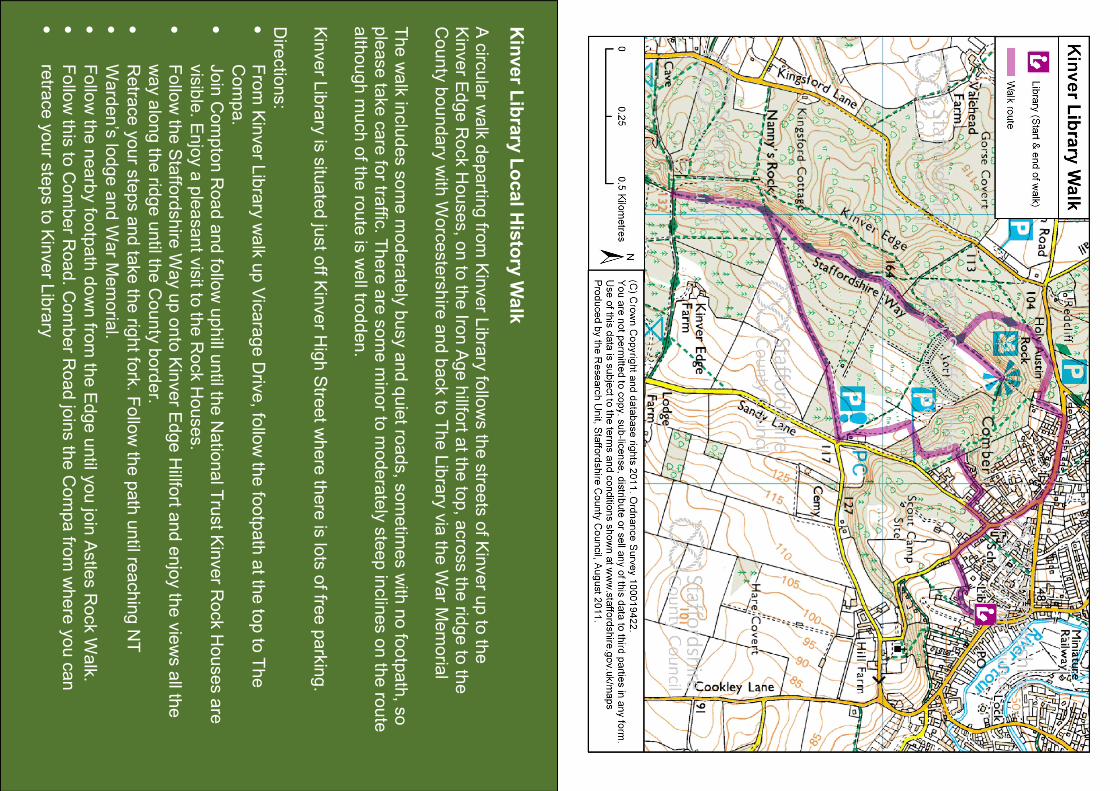
Kinver Library Local History Walk
A circular walk of 3.6 miles from Kinver Library
over Kinver Edge
Free
Kinver Library Local History Walk
A circ
ular w
alk departin
g fro
m Kinver L
ibrary fo
llows th
e stre
ets of K
inver u
p to
the
Kinver E
dge Rock H
ouses, o
n to
the Iro
n Age hillfo
rt at th
e to
p, a
cross th
e rid
ge to
the
County boundary w
ith W
orcestershire
and back to
The Library via th
e W
ar M
emoria
l The walk in
cludes some m
oderately busy and quiet ro
ads, s
ometim
es with
no fo
otpath, s
o
please ta
ke care fo
r traffic
. There are some m
inor to
moderately steep in
clines on th
e ro
ute
alth
ough m
uch of th
e ro
ute is well tro
dden.
Kinver L
ibrary is
situ
ated ju
st o
ff Kinver H
igh Stre
et w
here th
ere is lo
ts of fre
e parking.
Dire
ctio
ns:
•
From Kinver L
ibrary walk up Vicarage Driv
e, fo
llow th
e fo
otpath at th
e to
p to
The
Compa.
•
Join Compton Road and fo
llow uphill u
ntil th
e Natio
nal T
rust K
inver R
ock Houses are
visible. E
njoy a pleasant v
isit to
the Rock Houses.
•
Follo
w th
e Staffo
rdshire
Way up onto Kinver E
dge Hillfo
rt and enjoy th
e views all th
e
way along th
e rid
ge until th
e County border.
•
Retra
ce your s
teps and ta
ke th
e rig
ht fo
rk. F
ollow th
e path until re
aching NT
•
Warden’s lo
dge and W
ar M
emoria
l.
•
Follo
w th
e nearby fo
otpath down fro
m th
e Edge until y
ou jo
in Astle
s Rock W
alk.
•
Follo
w th
is to
Comber R
oad. C
omber R
oad jo
ins th
e C
ompa fro
m where you can
•
retra
ce your s
teps to
Kinver L
ibrary


![Rutland Local History & THE WALK Record Society [1]](https://static.fdocuments.in/doc/165x107/61689bcdd394e9041f7117b5/rutland-local-history-amp-the-walk-record-society-1.jpg)