HISTORICAL SITE ASSESSMENT CURTIS BAY, MARYLAND · The CBD site is located approximately one mile...
103
Transcript of HISTORICAL SITE ASSESSMENT CURTIS BAY, MARYLAND · The CBD site is located approximately one mile...


Historical Site Assessment of Curtis Bay Depot projects/0431/HSA/2005-05-17 HSA Curtis Bay.doc
HISTORICAL SITE ASSESSMENT OF THE CURTIS BAY DEPOT
CURTIS BAY, MARYLAND
Prepared by
E. W. Abelquist and T. J. Bauer Environmental Survey and Site Assessment Program
Oak Ridge Institute for Science and Education Oak Ridge, Tennessee 37831-0117
Prepared for the
Defense National Stockpile Center Defense Logistics Agency
FINAL REPORT
MAY 2005


Historical Site Assessment of Curtis Bay Depot projects/0431/HSA/2005-05-17 HSA Curtis Bay.doc i
HISTORICAL SITE ASSESSMENT OF THE CURTIS BAY DEPOT
CURTIS BAY, MARYLAND
TABLE OF CONTENTS
LIST OF FIGURES ....................................................................................................................... iii
1.0 GLOSSARY OF TERMS, ACRONYMS, AND ABBREVIATIONS................................1
2.0 EXECUTIVE SUMMARY .................................................................................................3
3.0 PURPOSE OF THE HISTORICAL SITE ASSESSMENT ................................................4
4.0 PROPERTY IDENTIFICATION ........................................................................................5 4.1 Physical Characteristics .......................................................................................... 5
4.1.1 Licensee Information .................................................................................. 5 4.1.2 Site Information .......................................................................................... 5
4.2 Environmental Setting ............................................................................................ 5 4.2.1 Geology....................................................................................................... 6 4.2.2 Hydrogeology ............................................................................................. 6 4.2.3 Hydrology ................................................................................................... 6 4.2.4 Meteorology................................................................................................ 7
5.0 HISTORICAL SITE ASSESSMENT METHODOLOGY..................................................9 5.1 Approach and Rationale.......................................................................................... 9 5.2 Boundaries of Site................................................................................................... 9 5.3 Documents Reviewed ............................................................................................. 9
5.3.1 Existing Radiation Data .............................................................................. 9 5.3.2 NRC Licenses ........................................................................................... 10 5.3.3 Operating Records .................................................................................... 10
5.4 Property Inspections ............................................................................................. 11 5.5 Personal Interviews............................................................................................... 11
6.0 HISTORY AND CURRENT USAGE...............................................................................13 6.1 History .................................................................................................................. 13
6.1.1 Land Areas ................................................................................................ 14 6.1.2 Stockpiles/Stockpile Pads ......................................................................... 14 6.1.3 Former Ordnance Associated Areas ......................................................... 15 6.1.4 Burial Areas .............................................................................................. 15 6.1.5 Warehouses ............................................................................................... 17 6.1.6 A Line Buildings....................................................................................... 18 6.1.7 B Line Buildings ....................................................................................... 18 6.1.8 C Line Buildings ....................................................................................... 19 6.1.9 D Line Buildings....................................................................................... 19 6.1.10 E Line Buildings ....................................................................................... 20 6.1.11 F Line Buildings ....................................................................................... 20 6.1.12 G Line Buildings....................................................................................... 22 6.1.13 H Line Buildings....................................................................................... 22

Historical Site Assessment of Curtis Bay Depot projects/0431/HSA/2005-05-17 HSA Curtis Bay.doc ii
6.1.14 I Line Buildings ........................................................................................ 23 6.1.15 J and K Lines ............................................................................................ 23 6.1.16 Building 812 ............................................................................................. 24 6.1.17 Building 821 ............................................................................................. 24 6.1.18 Building 825 ............................................................................................. 24
6.2 Current Usage ....................................................................................................... 24 6.3 Adjacent Land Usage............................................................................................ 25
7.0 FINDINGS.........................................................................................................................27 7.1 Potential Contaminants ......................................................................................... 27 7.2 Potential Contaminated Areas .............................................................................. 28
7.2.1 Impacted Areas ......................................................................................... 29 7.2.2 Non-impacted Areas ................................................................................. 30
7.3 Potential Contaminated Media.............................................................................. 30 7.3.1 Surface Soil............................................................................................... 30 7.3.2 Subsurface Soil and Media ....................................................................... 30 7.3.3 Surface Water............................................................................................ 31 7.3.4 Groundwater ............................................................................................. 31 7.3.5 Structures .................................................................................................. 31
8.0 CONCLUSIONS AND CONCEPTUAL SITE MODEL..................................................33
9.0 REFERENCES ..................................................................................................................35 APPENDICES
A. Questions Useful for the Preliminary HSA Investigation (from MARSSIM) B. Building Conditions and Photographic Documentation

Historical Site Assessment of Curtis Bay Depot projects/0431/HSA/2005-05-17 HSA Curtis Bay.doc iii
LIST OF FIGURES
PAGE
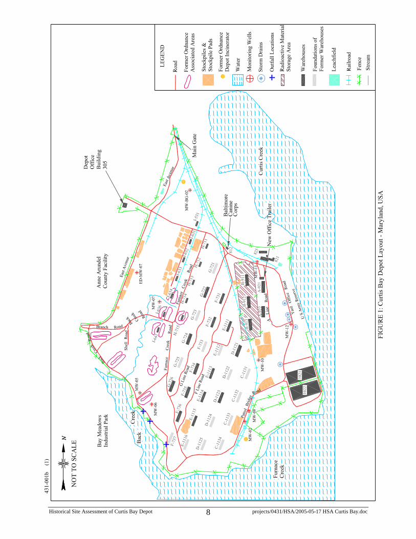
FIGURE 1: Curtis Bay Depot Layout – Maryland, USA............................................................8
FIGURE 2: Curtis Bay Depot, Conceptual Model – Maryland, USA ......................................34

Historical Site Assessment of Curtis Bay Depot projects/0431/HSA/2005-05-17 HSA Curtis Bay.doc 1
1.0 GLOSSARY OF TERMS, ACRONYMS, AND ABBREVIATIONS
AEC Atomic Energy Commission
ATG Allied Technology Group
BTP Branch Technical Position
CBD Curtis Bay Depot
D&D decontamination and decommissioning
DCGL derived concentration guideline level
dpm/100 cm2 disintegrations per minute per 100 square centimeters
DLA Defense Logistics Agency
DNSC Defense National Stockpile Center
DQO Data Quality Objectives
EPA Environmental Protection Agency
ESSAP Environmental Survey and Site Assessment Program
FEMA Federal Emergency Management Agency
FSI focused site investigation
FSS final status survey
GSA General Services Administration
HSA Historical Site Assessment – a detailed investigation to collect existing information, primarily historical, on a site and its surroundings.
HQ headquarters
Impacted Area Any area that is not classified as non-impacted; areas with a possibility of containing residual radioactivity in excess of natural background or fallout levels.
MARSSIM Multi-Agency Radiation Survey and Site Investigation Manual
MDC minimum detectable concentration
MdDE Maryland Department of the Environment

Historical Site Assessment of Curtis Bay Depot projects/0431/HSA/2005-05-17 HSA Curtis Bay.doc 2
mR/h milliroentgen per hour
NTS Nevada Test Site
Non-Impacted Area Area where there is no reasonable possibility (extremely low probability) of residual contamination.
NRC U.S. Nuclear Regulatory Commission
ORISE Oak Ridge Institute for Science and Education
ORNL Oak Ridge National Laboratory
pCi/g picocuries per gram
RSO radiation safety officer
RSSI radiation survey and site investigation
SDMP Site Decommissioning Management Plan
ThN thorium nitrate

Historical Site Assessment of Curtis Bay Depot projects/0431/HSA/2005-05-17 HSA Curtis Bay.doc 3
2.0 EXECUTIVE SUMMARY
The Defense National Stockpile Center (DNSC) of the Defense Logistics Agency (DLA) is in the process of closing out its depots across the country and seeking to terminate its U.S. Nuclear Regulatory Commission (NRC) license for those facilities. Curtis Bay Depot (CBD) stores various stockpiled ores such as chromite, ferromanganese, and ferrochrome. Some of the commodities stored at CBD—thorium nitrate (ThN), monazite sands, and sodium sulfate—are radioactive materials and are or were listed on the DNSC’s NRC source material license STC-133 that permits the storage of uranium and thorium. The license was recently amended to conduct site cleanup activities.
According to the Multi-Agency Radiation Survey and Site Investigation Manual (MARSSIM [1]), radiological surveys in support of decommissioning follow a graded approach that starts with the Historical Site Assessment (HSA). The HSA is an investigation to collect existing information describing a site’s complete history from the start of site activities to the present time to determine the potential for radiological contamination and to use the collected data to plan for future radiological surveys at the site.
Visits to review available documentation were performed on January 25 to 27, 2005 to the CBD and February 8 and 9, 2005 to the DNSC headquarters (HQ) in Fort Belvoir, VA. Documents reviewed included historical radiological survey reports, decontamination reports, the NRC license and associated letters; various internal memos, inventory record cards, and preliminary assessment reports of CBD. During the site visit to CBD, information concerning hazardous site conditions as it applies to conducting future survey work was noted. The structural integrity of buildings was identified as a potential problem that may impede future radiological survey work.
A number of building and soil areas will be considered to be potentially classified as Class 1 or Class 2 impacted areas. These include areas known to be contaminated (B-911 and B-912), areas that were previously contaminated and remediated or demolished (F-731; F-737; and, J and K Line buildings), and areas potentially contaminated (1022, A-921, B-913, F-734, F-735, F-736, F-721, and H Line buildings). Existing roads, railroad lines, and areas where railroad lines were removed will also be considered to be potentially contaminated (Class 2). The radioactive burial pit in the southwest portion of the site is considered to be potentially contaminated (Class 1). A dump on the south side of the site near where the former Ordinance Depot Incinerator was located is considered to be potentially contaminated (Class 2). The remaining land areas are considered to have little potential for contamination, and may be considered Class 3.

Historical Site Assessment of Curtis Bay Depot projects/0431/HSA/2005-05-17 HSA Curtis Bay.doc 4
3.0 PURPOSE OF THE HISTORICAL SITE ASSESSMENT
The Defense National Stockpile Center (DNSC) of the Defense Logistics Agency (DLA) is in the process of closing out its depots across the country and seeking to terminate its U.S. Nuclear Regulatory Commission (NRC) license for those facilities. Curtis Bay Depot (CBD) stores various stockpiled ores such as chromite, ferromanganese, and ferrochrome. Some of the commodities stored at CBD, such as thorium nitrate (ThN), are radioactive materials and are listed on the DNSC’s NRC source material license STC-133 that permits the storage of uranium and thorium. The license was recently amended to conduct site cleanup activities.
The DNSC contracted with Oak Ridge National Laboratory (ORNL) to assist them with the removal of the thorium nitrate stockpile from the CBD and its ultimate disposition at a disposal site. Three phases were identified to perform this task: Phase I was historical data assembly, Phase II was the stockpile characterization, and Phase III is stockpile disposition which is currently ongoing [2]. Once the last drum of the thorium nitrate stockpile leaves the CBD, scheduled for May 2005 for disposal at the Nevada Test Site (NTS), Phase III will be complete. Phase IV is the decommissioning of the CBD, including Multi-Agency Radiation Survey and Site Investigation Manual (MARSSIM [1]) surveys and necessary cleanup of buildings and land areas, to permit unrestricted use of the site.
According to the MARSSIM, surveys in support of decommissioning follow a graded approach that starts with the Historical Site Assessment (HSA) and is later followed by other surveys that lead to the final status survey. The HSA is an investigation to collect existing information describing a site’s complete history from the start of site activities to the present time. The HSA is the first step in the MARSSIM process on the path to license termination.
The purpose of the HSA at CBD was to:
• identify potential, likely, or known sources of radioactive material and radioactive contamination based on existing or derived information
• provide an assessment of the likelihood of contaminant migration
• provide information useful to scoping and characterization surveys
• provide initial classification of the site or survey unit as impacted or non-impacted

Historical Site Assessment of Curtis Bay Depot projects/0431/HSA/2005-05-17 HSA Curtis Bay.doc 5
4.0 PROPERTY IDENTIFICATION
4.1 Physical Characteristics
The Curtis Bay Depot (CBD) property has approximately seventy-four buildings, many in a severely deteriorated condition, on approximately 483 acres (refer to Figure 1) [3]. Buildings on the CBD were situated on roughly parallel railroad spurs from the main track that entered the site near the main gate. There were two to seven buildings along each spur. Each spur was labeled alphabetically; for example, the A Line consisted of two buildings while the F and K Lines consisted of seven buildings. The Oak Ridge Institute for Science and Education (ORISE) performed a limited review of the buildings’ conditions on January 26, 2005 during an onsite visit. While a number of the buildings have been completely removed, the remaining buildings are in a dilapidated state. Oak Ridge National Laboratory (ORNL) performed a comprehensive safety evaluation of the buildings in February and March 2005. Section 6.1 and Appendix B provide an assessment of building conditions.
The U.S. Army Reserve uses the dock area on Curtis Creek on the east side of the site for maintenance of Army tugboats. The area used by the U.S. Army Reserve is outside the control of the General Services Administration (GSA) and therefore is not considered in the scope of Phase IV.
The Baltimore Canine Corps uses Building 812 located on the northeast side of the site as a training area for police dogs. This is also not considered in the scope of Phase IV.
4.1.1 Licensee Information
The CBD is currently owned by the federal government (GSA) and operated by the Defense National Stockpile Center (DNSC) of the Defense Logistics Agency (DLA). The DLA headquarters address is 8725 John J. Kingman Road, Suite 3229, Ft. Belvoir, VA 22060-6223.
4.1.2 Site Information
The CBD site is located approximately one mile south of Baltimore, Maryland in an industrialized area of Anne Arundel County, Maryland. The site address is Curtis Bay Depot, 710 East Ordnance Road, Curtis Bay, MD 21226.
The geographic coordinates of the CBD are latitude N391140 and longitude W763524 on the Curtis Bay Quadrangle, MD (7.5-minute quadrangle U.S. Geological Survey topographical map) [3].
4.2 Environmental Setting
In general, the CBD terrain is mostly flat to gently hilly with large grassy, open areas, and some lightly wooded areas. The site contains various structures (buildings and warehouses)—some functional, others in a serious state of disrepair. A few buildings are

Historical Site Assessment of Curtis Bay Depot projects/0431/HSA/2005-05-17 HSA Curtis Bay.doc 6
surrounded by man-made berms of earth, that over the years since their construction have been vegetated with small trees and brush. A number of roads, mostly asphalt, traverse the site; there are approximately six miles of paved roads [3]. Also noteworthy are the large stockpiles of various ores that cover the terrain. There are two miles of railroad tracks that cross the site, a stream, and two leach fields – one in use. There are two wetland areas on the southwest and south sides of the site.
4.2.1 Geology
The CBD is approximately five miles east of the boundary between the Coastal Plain and the Piedmont Physiographic Province known as the Fall Line. The alluvial Coastal Plain sediments beneath the CBD generally thicken from west to east and are a part of the Lower Cretaceous Potomac Group. In the Baltimore area, the Potomac Group consists primarily of unconsolidated clays, silts, sands, and gravels. A silt-clay facies of the Potomac Formation consisting of shallow clay underlain by a water-bearing sand and gravel unit exists beneath the CBD [4].
4.2.2 Hydrogeology
According to the Parsons 2003 report [3]:
At the Depot, groundwater is found in the surficial sediments overlying a shallow clay layer, often as perched conditions. In the western portion of the site, where perched conditions are not present, groundwater is found under unconfined aquifer conditions. Groundwater is found at 11 feet to 16 feet bgs [below ground surface] in the eastern portion of the Depot, and 20 feet to 40 feet bgs in the western portion. An average groundwater flow velocity value of 0.8 foot/day was estimated for the shallow aquifer, with flow direction generally from west to east, towards Curtis Creek (Reference 5). However, it is likely that there are components of groundwater flow that move westward with discharge to Back Creek. There is slight tidal influence on the uppermost groundwater zone at the site.
4.2.3 Hydrology
Surface water drainage routes at the CBD generally flow from north to south and east to large bodies of water. Ground surface elevations range from 10 to 50 feet above mean sea level. CBD is surrounded by three creeks—bordered on the southwest by Back Creek, on the south by Furnace Creek, and on the east by Curtis Creek. Two small streams on the western portion of the site, beginning at and flowing west from the I Line, converge and empty into Back Creek. Furnace Creek flows into Curtis Creek which flows into Curtis Bay. Approximately 2.5 miles from CBD, Curtis Bay flows into the Patapsco River, and approximately five miles from CBD, the Patapsco River flows into the Chesapeake Bay [4].

Historical Site Assessment of Curtis Bay Depot projects/0431/HSA/2005-05-17 HSA Curtis Bay.doc 7
4.2.4 Meteorology
The average annual total precipitation reported for Anne Arundel County is 41.93 inches and 44.68 inches at the Baltimore airport and Annapolis Police Barracks, respectively. Precipitation between the months of April and October accounts for 60% of the average. The heaviest 1-day rainfall event recorded at the Annapolis Police Barracks—during the reporting period covering the years 1971-2000—was 8.32 inches in 1999. Thunderstorms occur roughly 28 days a year, mostly between the months of May and August. The average seasonal snowfall is 18.0 inches and 7.4 inches at the Baltimore airport and Annapolis Police Barracks, respectively. The prevailing wind is from the west, with the average speed highest between 10 and 11 miles per hour (4.5 to 4.9 meters per second) from February to April [5].
Historical Site Assessment of Curtis Bay Depot projects/0431/HSA/2005-05-17 HSA Curtis Bay.doc 8
Historical Site Assessment of Curtis Bay Depot projects/0431/HSA/2005-05-17 HSA Curtis Bay.doc 9
5.0 HISTORICAL SITE ASSESSMENT METHODOLOGY
The following was the approach used to conduct the Historical Site Assessment (HSA).
5.1 Approach and Rationale
This limited scope investigation serves to collect readily available information concerning the Curtis Bay Depot (CBD). Visits to review available documentation were performed on January 25 to 27, 2005 at the CBD and February 8 and 9, 2005 at Fort Belvoir, VA. The investigation is designed to obtain sufficient information to provide initial classification of the site or survey unit as impacted or non-impacted. Information on the potential distribution of radioactive contamination may be used for classifying each part of the site or survey unit as Class 1, 2, or 3 and is useful for planning scoping and characterization surveys.
Appendix A provides a set of questions that was used to assist in the preliminary HSA investigation (adapted from MARSSIM Table 3.1). This table focuses on characteristics that may help to identify a previously unrecognized source of potential contamination. Furthermore, these questions may identify confounding factors for selecting reference sites.
5.2 Boundaries of Site
The property currently consists of approximately 483 acres bounded on the north by Curtis Creek, on the east by the Army Reserve Facility and Curtis Creek, on the south by Furnace Creek, and on the west by Back Creek and the Anne Arundel County Facility [3]. A 1,955-foot long dock lies along Curtis Creek; a security fence encloses the facility. The dock is the property of the U.S. Army Reserve, and outside the scope of decommissioning [6].
5.3 Documents Reviewed
Documents reviewed included historical radiological survey reports, decontamination reports, the U.S. Nuclear Regulatory Commission (NRC) license and associated letters, various internal memos, inventory record cards, preliminary assessment reports of CBD, and selected Phase III reports [7 through 12]. This section discusses some of the information identified in the reviewed documents. Refer to Section 9.0 for a specific listing of documents reviewed.
5.3.1 Existing Radiation Data
Existing site data may provide specific details about the identity, concentration, and areal distribution of contamination. A number of reports were reviewed that related to previous cleanup actions in several buildings in the F, J, and K Lines, as well as the former radioactive waste burial pit. These reports contained survey data. However, these data should be examined carefully because:

Historical Site Assessment of Curtis Bay Depot projects/0431/HSA/2005-05-17 HSA Curtis Bay.doc 10
• Previous survey and sampling efforts may not be compatible with HSA objectives or may not be extensive enough to characterize the facility or site fully.
• Measurement protocols and standards may not be known or compatible with HSA objectives (e.g., Quality Assurance/Quality Control (QA/QC) procedures, limited analysis rather than full-spectrum analysis) or may not be extensive enough to characterize the facility or site fully.
• Conditions may have changed since the site was last sampled (i.e., substances may have been released, migration may have spread the contamination, additional waste disposal may have occurred, or decontamination may have been performed). An important point at CBD was the possibility of subsequent storage in a building of a radiological material after a record was generated stating the building was released.
5.3.2 NRC Licenses
Amendment No. 24 of license number STC-133 (May 5, 2003) licenses uranium and thorium specifically as natural uranium and thorium mixtures as ores, concentrates, and solids. The NRC transmittal letter requested copies of remediation plans and final status survey plans for review and approval prior to implementation [13]. The identified radioactive materials indicated in NRC correspondence include thorium nitrate (ThN), monazite sands, and sodium sulfate—all radioactive materials that contain thorium, and to a lesser amount, uranium.
5.3.3 Operating Records
A number of records were reviewed that described onsite activities; current and past contamination control procedures; and past operations involving demolition, effluent releases, discharge to sewers or onsite septic systems, waste and material storage, spills and accidental releases, release of facilities or equipment from radiological controls, and onsite or offsite radioactive and hazardous waste disposal. Of particular interest were the records describing the establishment of a new radioactive burial pit onsite and subsequent actions to remove the area from the NRC license.
Information on accidents, such as the flooding event in Building B-912 that soaked hundreds of thorium nitrate containers, was collected as a potential source of contamination. Possible areas of localized contamination were identified.
Site plats or plots, blueprints, drawings, and sketches of structures were also useful to illustrate the location and layout of buildings on the site (which helped to identify that building designations had changed over time). Site photographs and maps were also helpful in learning about the CBD history.

Historical Site Assessment of Curtis Bay Depot projects/0431/HSA/2005-05-17 HSA Curtis Bay.doc 11
Corporate contract files, especially those reviewed at the Defense National Stockpile Center’s (DNSC) Fort Belvoir headquarters (HQ), provided useful information about the potential contamination at CBD. Records were identified that provided information helpful to reconstruct the site’s operational history.
5.4 Property Inspections
The objective of the January 25 to 27, 2005 site visit was to gather sufficient information to support a decision regarding further survey actions. The site visit offered an opportunity to record information concerning hazardous site conditions as they apply to conducting future survey work. In this regard, information describing physical hazards, structural integrity of buildings (perhaps the most important part of the site visit that will be used to plan for future scoping activities), or other conditions, defined potential problems that may impede future survey work. Appendix B provides photographs of current conditions for many of the CBD buildings.
5.5 Personal Interviews
Interviews with current or previous employees were performed to collect first-hand information about the site and to verify or clarify information gathered from existing records. Interviews covered general topics, such as thorium nitrate handling and disposal procedures.
The following DNSC employees and subcontract staff working with thorium nitrate were interviewed by ORISE during HSA visits to CBD and DNSC HQ at Fort Belvoir.
Mike Pecullan
M. Pecullan (Radiation Safety Officer (RSO), Environmental Specialist, DNSC) provided historical information as he has been involved with CBD since September 1979. The interview extensively discussed history of site operations and nature and locations of radioactive materials. The discussion also included the ThN Overpackaging Project and radioactive burial pit relocation. M. Pecullan also assisted with a tour of the facility to review the site layout and condition of buildings on site.
Lois Huddlestun
L. Huddlestun (New Haven, Indiana Depot, DNSC) provided a summary spreadsheet [14] based on review of historical documents where thorium nitrate, thorium hydroxide, thorium oxide, monazite sand, sodium sulfate, and rutile were stored. Rutile is a form of titanium oxide—after a review of analytical records it was determined that rutile sand has essentially no thorium dioxide and therefore was not considered a contaminant. L. Huddlestun also provided document retrieval and assistance during the site tour.

Historical Site Assessment of Curtis Bay Depot projects/0431/HSA/2005-05-17 HSA Curtis Bay.doc 12
Bill Hermes
B. Hermes (Project Manager, ThN Project, Oak Ridge National Laboratory (ORNL)), provided a thorium nitrate chemical discussion to help understand the difference between reported analytical results and theoretical thorium concentrations. This enabled better understanding of the nature of the thorium material.
F. Kevin Reilly
K. Reilly (Director, Environmental Management, DNSC) provided additional information regarding the on-site radioactive burial pit.

Historical Site Assessment of Curtis Bay Depot projects/0431/HSA/2005-05-17 HSA Curtis Bay.doc 13
6.0 HISTORY AND CURRENT USAGE
6.1 History
The original U.S. Army Depot was built in 1918 on 798 acres of farmland. Additional acreage was acquired, increasing the site to 815 acres. From 1918 to 1954 the site was used for receiving, shipping, and storage, and as an ordnance depot (storing ammunition) [3].
The National Stockpile program was established in 1946 as an attempt to mitigate dependence on foreign sources of vital materials during times of national emergencies. In the late 1950s, the Defense National Stockpile Center (DNSC) became a tenant at the Curtis Bay Depot (CBD) and began storing strategic materials (bulk ores, minerals, and metals).
Between 1958 and 1966, approximately 37 acres were transferred to the U.S. Army Reserve Command [3]. In the mid 1960s, the remaining 778 acres were excessed to the General Services Administration (GSA) which had assumed accountability for the facility.
In 1966, CBD land including the area of the old radioactive burial site was sold to Anne Arundel County, and in turn developed into an industrial park (Bay Meadows Industrial Park) [15].
Beginning in the late 1950s, GSA stored thorium nitrate (mantle and reactor grades, average 47 percent thorium nitrate by weight) in fiber and steel drums at the CBD, under U.S. Atomic Energy Commission (AEC) (and later U.S. Nuclear Regulatory Commission (NRC)) License STC-133. In 1977, GSA notified NRC of its intention to excess the empty warehouses as part of a sale of U.S. Government land and buildings. The property was sold, and then transferred to Anne Arundel County in the late 1970s and early 1980s. In 1988, National Defense Stockpile responsibility was transferred to the Defense Logistics Agency (DLA) [16].
In 1980, GSA sold approximately 87 acres to Anne Arundel County. This property had contained nine warehouses that were used to store thorium nitrate. The site was cleaned up (see section 6.3) and that portion released from the NRC license. The County eventually built a detention center and ball fields on the property [3].
The various transfers of property to Anne Arundel County and the Maryland Department of Transportation have resulted in a current CBD size of 483 acres.
Up until 1988, the National Stockpile was managed by both the Federal Emergency Management Agency (FEMA) and the GSA [4]. The DNSC is currently managed by the DLA. CBD is one of about 15 depots being operated by DNSC that are either GSA-owned or leased properties [3].

Historical Site Assessment of Curtis Bay Depot projects/0431/HSA/2005-05-17 HSA Curtis Bay.doc 14
Since the mid 1970s, there have been several decontamination actions resulting in the NRC granting release from the license. Areas released from the license included building F-737, L and M Line buildings and land areas, and the radioactive burial pit.
6.1.1 Land Areas
The 483 acres that comprise the current CBD site include stockpiled ores, warehouses, buildings, building pads, paved and dirt roads, rail lines and beds, and natural features such as grassy open areas, lightly wooded areas, wet lands, and small streams. The next few sections provide additional details on the stockpiled ores, earthen berms, and burial areas located on the site. Appendix B provides photographs of many CBD site buildings.
While radioactive materials were generally stored in strong containers, the potential for contamination of land and related infrastructure due to movement of materials throughout the site should be evaluated. An allegation on July 20, 1993, by Eric H. Reber, a former employee at the CBD, included three main concerns. These included decontamination of railroad cars in the 1960s, deteriorated drums contaminated with thorium buried in the on-site burial pit, and that employees may have buried radioactive material at what is now the Bay Meadows Industrial Park. The NRC initiated an inspection at the site in response to the allegation. For the decontamination of the railroad cars, the NRC findings were that no radiation levels above background were noted in the area where the decontamination occurred or at the end of the drains leading from the area. The area, which is also referred to as the former fluorspar berm [17], was noted by the former employee as being adjacent to the on-site burial site (assumed to be referring to the on-site radioactive burial pit). The NRC reviewed the former employee’s information regarding the radioactive burial pit and found the information consistent with the information provided by the licensee. During the inspection, a survey with a microR meter did not identify radiation levels above background. Based on the review of the Bay Meadows burial of radioactive waste, the NRC concluded that it was unlikely significant contamination remained in the area [18, 19].
6.1.2 Stockpiles/Stockpile Pads
Most of the stockpiled materials at CBD are raw ores. They are primarily piled on concrete pads or directly on the ground. Some piles are covered to reduce erosion through weathering and oxidation.
The individual stockpiles were organized by Parsons [3] into general areas representing several types of stored materials.
Stockpile Area 1 – 1300 ft by 200 ft and comprises stockpiles of beryl ore, ferrochrome, and ferromanganese. The stockpiles are uncovered and staged on a concrete pad with visible cracks.
Historical Site Assessment of Curtis Bay Depot projects/0431/HSA/2005-05-17 HSA Curtis Bay.doc 15
Stockpile Area 2 – 900 ft by 200 ft and comprises stockpiles of beryl ore, manganese acid grade, and manganese chemical grade. The manganese piles are covered.
Stockpile Area 3 – 500 ft by 300 ft and comprises titanium sponge (drums stored on concrete blocks), and stockpiles of aluminum oxide, fluorspar, ferrochrome, and manganese chemical grade.
Stockpile Area 4 – 1200 ft by 200 ft and comprises titanium sponge (drums stored on concrete blocks), and stockpiles of chromite chemical, chromite refractory, and manganese chemical grade. The manganese piles are covered.
From the historical review, no radioactive materials (thorium nitrate, oxide, and hydroxide, monazite sands, and sodium sulfate) were stored on the pads.
6.1.3 Former Ordnance Associated Areas
The former ordnance associated areas include the four earthen berms (bunkers) that are located on the western portion of the site. In 1998, according to the Depot Manager, some live small arms ammunition was found buried in the southeast corner of the CBD. A contractor identified numerous unfuzed Stokes mortar rounds and a 2.36-inch bazooka round. Removal actions were completed, but several other areas across the CBD were investigated with a magnetometer and many geophysical anomalies were identified [3].
6.1.4 Burial Areas
Former Radioactive Waste Burial Pit Area
The original waste disposal site was located approximately 4,300 feet from the main office building, and was between bunkers 1252-Q and 1253-Q and Farm House Road, which was located in what is now the Bay Meadows Industrial Park, across Back Creek. The land was sold in 1966 [15]. In 1962, a complete overpackaging program for all 20,400 drums was completed. The zinc clad bands and wooden tops and bottoms were placed in the burial pit [20]. The wood tops and bottoms were found to be slightly contaminated at levels below Atomic Energy Commission (AEC) Part 20 Appendix C values [21]. The original burial pit was moved to a triangular portion of land that is bounded by Branch Run Creek, Back Creek Road, and Fluorspar Barricade 646 (refer to Figure 2) [22].
Scrap pieces and soil were transferred to a new burial site in the 1965 to 1966 timeframe (reference mentioned 1959 but the date appears to be incorrect) [15]. Corroded fiber and tops and bottoms from 22,000 thorium nitrate drums were moved from the old burial site according to a memo dated June 14, 1965 and a 1984 letter [22, 23]. The new burial pit area encompassed 1,000 ft2 and the waste consists of debris from a thorium nitrate overpackaging project and various other materials shipped to the depot from other stockpile sites [24]. Gamma readings at

Historical Site Assessment of Curtis Bay Depot projects/0431/HSA/2005-05-17 HSA Curtis Bay.doc 16
ground level ranged from background to 0.06 mR/h, indicating activity in the ground [25]. The burial pit contained thorium nitrate contaminated wooden tops, fiber drums, metal banding, etc., and several drums of beryllium compound in the 50 ft by 30 ft by 15 ft deep pit—the referenced document does, in fact, indicate the burial pit is 50 ft in length but the actual dimension is larger. RSO, Inc. performed a radiological environmental assessment during August and September 1985 to establish radiation levels at the burial site [26].
An environmental assessment was performed August 13 through September 5, 1985. Eight bore holes were systematically located within the suspected burial pit area and four were located around the burial pit perimeter (Enclosure 2 of the RSO, Inc. report provides a map of the bore hole locations). Samples were collected at the surface and at depths of 4 feet, 8 feet, 12 feet, and 16 feet. Enclosure 3 of the RSO, Inc. report provides a narrative of the bore hole sampling results. For example, at bore hole location C, soil samples were not typical of surrounding material, and a suspicious green material was encountered at 1.5 feet. At bore hole location G, sample G-5 at 16 feet had large grainy rust particles that were red and black in color. A plastic bag and wood were identified at one of the perimeter locations, bore hole L at 4 feet, indicating uncertainty in the boundary of the burial pit [27].
The mean concentration of Th-232 for all 57 samples was less than 0.7 pCi/g. The report concluded that the burial pit residual concentration was indistinguishable from naturally occurring background. The background concentration was determined to be 0.7 pCi/g based on four samples collected from the surrounding area within approximately 100 m of the burial pit. The report summarizes, “At the present time, it can be concluded that there is no leaching of any radioactive materials, specifically thorium-232 from the burial site to the surrounding environment.” The analysis of the soil samples included wet chemistry to isolate the natural thorium and then counting using an internal gas flow proportional counter [27].
Inspection of the individual sample results from Enclosure 5 of the RSO, Inc. report noted the following Th-232 sample results that were distinguishable from background: sample C2 was 4.43 pCi/g, E3 was 1.64 pCi/g, and H3 was 1.4 pCi/g; all samples had a minimum detectable concentration (MDC) of 0.7 pCi/g. These three samples had the highest three reported concentrations. This list does not include every sample result greater than MDC [27].
Parsons also reviewed the history of the CBD in the Final Expanded Site Investigation Report [3] and noted the burial of thorium nitrate material in 1965 and four drums of beryllium oxide in 1969. These materials were reportedly removed in 1987 (with the approval of the State of Maryland) after soil samples were collected in a 1987 investigation. The report is not clear what material was removed, but based on discussion with DLA personnel, it is likely that only the beryllium oxide material was actually removed. Because it was unclear if

Historical Site Assessment of Curtis Bay Depot projects/0431/HSA/2005-05-17 HSA Curtis Bay.doc 17
groundwater monitoring was performed in the 1987 investigation, one groundwater monitoring well was installed during the Parson’s investigation.
A corrected copy of Amendment 9 of STC-133 license releasing the burial site for unrestricted use dated June 16, 1986, stated that “The Burial site at the Curtis Bay Depot is released for unrestricted use [28].”
Medical Supplies Burial Area
In 1996, a retired stockpile operations foreman reported that medical supplies had been buried at a location about 100 yards from the south end of the G Line Road. Exploratory trenches were dug in 1996 and numerous bottles were discovered about 8 feet below ground surface. Radiological material was not identified. Two monitoring wells were installed [3]. The 1999 Parsons focused site investigation (FSI) recommended that further investigation be performed for the Medical Supplies Burial Area to better define the nature and extent of contamination [4]. From the document review, there is very low potential for radioactive material to be buried at this location.
6.1.5 Warehouses
There are two buildings used as warehouses at CBD: Buildings 1021 and 1022, which were previously designated as Warehouse No. 1 and Warehouse No. 2, respectively. The dimensions of these buildings are 240 ft by 600 ft. Both buildings were similarly constructed which included poured concrete floors, a structural frame of wood columns supporting wood trusses and joists, a built-up roof, and brick masonry exterior walls with transom windows and roll-up doors [29].
Building 1021
As of January 2005, this building was still standing. An inspection of the exterior of the building was not performed. Based on the condition of Building 1022 (discussed below), it is likely that Building 1021 is in a state of similar deterioration.
No history of radioactive materials storage was noted for this building.
Building 1022
This building has exterior aluminum siding over the brick masonry exterior and there are concrete loading docks on the north, south and west elevations, and a concrete slab on grade on the east elevation. Lighting exists from electrical conduit hung from trusses, and a dry pipe sprinkler system is present [29]. As of January 2005, this building was still standing, with one section of the roof in a state of imminent collapse.

Historical Site Assessment of Curtis Bay Depot projects/0431/HSA/2005-05-17 HSA Curtis Bay.doc 18
A clean-up action was performed at an unspecified date and noted as “Project 861.” Thorium nitrate was also present in the building per a “3DM-C” letter dated August 10, 1979. Radiological Survey 7-Amended signed October 4, 1979 appears to indicate the end of thorium nitrate storage/staging. Thorium nitrate was also noted as being staged in this building again in 1997, as well as thorium hydroxide and thorium oxide [14].
6.1.6 A Line Buildings
The A Line consists of Buildings A-921 and A-922, which were previously designated as A1 and A2, respectively. The dimensions of these buildings are 50 ft by 220 ft. Both buildings were similarly constructed which included poured concrete floors, a structural frame of wood trusses resting on brick masonry piers, tongue and groove wood plank roofs covered by asphalt shingles, and terra cotta block exterior walls covered by aluminum siding with five roll-up doors. There is a concrete slab loading dock on the east elevation of each building and lighting exists from electrical conduit hung from trusses [29]. As of January 2005, both buildings were in good condition and were being used for surplus storage.
Building A-921
Packaged debris from an earlier decontamination project and storage of a metal conveyor used for a thorium nitrate drum over-packaging project were noted as being in this building [14]. One 55 gallon drum of monazite and two pounds of uranium pitch blend ore in a plastic bag were reportedly stored in this building [30]. The release of this building for unrestricted use was concurred by the NRC in a 1982 letter [31].
Building A-922
No history of radioactive materials storage was noted for this building.
6.1.7 B Line Buildings
The B Line consists of the following buildings, with the previous designations for the buildings noted in parentheses: B-911 (B3), B-912 (B4), and B-913 (B5). The dimensions of these buildings are 50 ft by 220 ft. All buildings were similarly constructed which included poured concrete floors, tongue and groove wood plank roofs covered by asphalt shingles, and brick masonry exterior walls with five roll-up doors. There is a concrete loading dock on the east elevation of each building [29]. As of January 2005, these buildings were in good condition.
A project is currently underway to remove thorium material from the B Line buildings. The area around these buildings is currently a radioactive material storage area [6].

Historical Site Assessment of Curtis Bay Depot projects/0431/HSA/2005-05-17 HSA Curtis Bay.doc 19
Building B-911
Thorium nitrate is currently stored in this building. Past locations of this material include K, L, M, and P (formerly known as the “farm” area) Line buildings, as well as Building 1022. A Trip Report by M. Pecullan dated May 1, 1980 showed this building to contain pitchblende ore, miscellaneous samples of monazite sand, thorium nitrate, and rare earth material. While the documentation notes Building A-911, it is likely a typographical error and was considered for this HSA applicable to Building B-911. Also, no other references to Building A-911 were noted during the review [14]. Floors of this building are contaminated and covered with epoxy to contain the contamination [6].
Building B-912
Thorium nitrate is currently stored in this building. Past locations of this material include J, K, L, and P (formerly known as the “farm” area) Line buildings, as well as Building 1022. Several references reviewed noted that a sprinkler drain pipe burst in the SW corner of the building saturating approximately 648 thorium nitrate fiber drums [14, 32, 33]. Floors of this building are contaminated and covered with epoxy to contain the contamination [6].
Building B-913
Thorium nitrate, thorium hydroxide, and thorium oxide are currently stored in this building. Past locations of this material include K, L, and P (formerly known as the “farm” area) Line buildings, as well as Building 1022 [14]. No contamination is known to exist on the floor of this building [6].
6.1.8 C Line Buildings
The C Line consists of the following buildings, with the previous designations for the buildings noted in parentheses: C-1131 (C6), C-1132 (C7), C-1133 (C8), and C-1134 (C9). All buildings were similarly constructed which included poured concrete floors, tongue and groove wood plank roofs covered by asbestos shingles, and terra cotta block exterior walls [34]. As of January 2005, for these buildings, only the concrete pads remain.
No history of radioactive materials storage was noted for these buildings.
6.1.9 D Line Buildings
The D Line consists of the following buildings, with the previous designations for the buildings noted in parentheses: D-1121 (D10), D-1122 (D11), D-1123 (D12), D-1124 (D13), and D-1125 (D14). All buildings were similarly constructed which included poured concrete floors, tongue and groove wood plank roofs covered by asbestos shingles, and terra cotta block exterior walls [34]. The table below summarizes the structural conditions of D Line buildings as of January 2005.

Historical Site Assessment of Curtis Bay Depot projects/0431/HSA/2005-05-17 HSA Curtis Bay.doc 20
Building(s) Structural Condition D-1121 Roof collapsed; only portions of walls standing D-1122, D-1124, D-1125 Only concrete pads remain D-1123 Roof partially collapsed
No history of radioactive materials storage was noted for these buildings.
6.1.10 E Line Buildings
The E Line consists of the following buildings, with the previous designations for the buildings noted in parentheses: E-1111 (E15), E-1112 (E16), E-1113 (E17), E-1114 (E18), E-1115 (E19), and E-1116 (E20). All buildings were similarly constructed which included poured concrete floors, tongue and groove wood plank roofs covered by asbestos shingles, and terra cotta block exterior walls [34]. The table below summarizes the structural conditions of E Line buildings as of January 2005. Building E-1111 was used for miscellaneous storage.
Building(s) Structural Condition E-1111 Roof collapsed at one section E-1112, E-1116 Only concrete pad remains E-1113, E-1114, E-1115
Roof collapsed; only portions of walls standing
No history of radioactive materials storage was noted for these buildings.
6.1.11 F Line Buildings
The F Line consists of the following buildings, with the previous designations for the buildings noted in parentheses: F-731 (F21), F-732 (F22), F-733 (F23), F-734 (F24), F-735 (F25), F-736 (F26), and F-737 (F27, T-737). The dimensions of these buildings are 50 ft by 220 ft. All buildings were similarly constructed which included poured concrete floors, tongue and groove wood plank roofs covered by asbestos shingles (except F-731 which was covered by asphalt shingles), and terra cotta block exterior walls with five roll-up doors. The exterior walls of building F-731 were also covered with aluminum siding. There is a concrete loading dock on the east elevation of each building. Lighting exists from electrical conduit hung from trusses and dry pipe sprinkler systems are present for Building F-731 [3, 34]. The table below summarizes the structural conditions of F Line buildings as of January 2005.
Building(s) Structural Condition F-731 Roof partially collapsed F-732, F-735, F-736 Roof collapsed F-733, F-737 Only concrete pads remain F-734 Roof collapsed; only portions of walls standing

Historical Site Assessment of Curtis Bay Depot projects/0431/HSA/2005-05-17 HSA Curtis Bay.doc 21
Building F-731
Thorium nitrate was also stored in this building based on Thorium Nitrate Air Monitoring, serial no. 1, dated March 8, 1984 and temporary storage for repackaging per Stockpile Inspection serial no. 34 signed February 29, 1984. Also noted was Thorium Stockpile Inspection serial no. Special, signed December 1, 1987. A request for NRC clearance of this building dated July 1, 1987 was also found but no NRC response was noted. Radiological Survey 21, signed June 14, 1989, states that the NRC released F-731 for unrestricted use in an NRC letter dated July 12, 1988 [14, 35]. In areas where the floor was contaminated, a thin top layer was scabbled [36].
In an NRC inspection report dated May 2, 1988 which cited results of Inspection No. 40-00341/87-002, the report states that Building F-731 is currently empty but was used in the past to store thorium nitrate-contaminated material and equipment used during the repackaging of deteriorating thorium nitrate drums [37].
Buildings F-732 and F-733
No history of radioactive materials storage was noted for these buildings.
Buildings F-734 and F-735
Thorium nitrate was stored in these buildings from 1963 to 1974 [38, 39]. A 1979 letter from the NRC that included discussion of in-process inspections of these buildings indicated that significant alpha contamination (greater than 90% of the floor in F-735 was contaminated) was remediated from the floors by vacuuming and using pneumatic hammers and drills [40]. The buildings were then released by the NRC for unrestricted use in a letter received March 31, 1980 [41]. These buildings were again released by the NRC for unrestricted use in a letter dated March 25, 1989, which was later retracted by the NRC based on the new guidelines [14]. No documentation was found describing the use of the buildings during the years between the 1980 and 1989 releases. These buildings were retracted in the same manner the areas of the Anne Arundel County excessed property were retracted and resurveyed [6].
Building F-736
Monazite sand was stored in this building [42]. No information was found to indicate how the monazite sand was stored in this building. Monazite sand was stored in bulk (not in drums) in Building F-737 and may have been stored as bulk in this building as well [6]. The building was also noted to be contaminated and required decontamination [43].

Historical Site Assessment of Curtis Bay Depot projects/0431/HSA/2005-05-17 HSA Curtis Bay.doc 22
Building F-737
This building was used to store monazite sands in bulk form (not in drums) [6]. References identified for this building included “Stockpile Sites N Stuff” dated August 1977, Radiological Survey 1 dated February 22-23, 1978, GSA-DM letter dated July 15, 1983, and Radiological Survey 25 signed November 24, 1993. A request for release of the building was signed November 24, 1993 [14].
A December 1994 report from the NRC stated that the building met unrestricted release criteria, but soils surrounding the building did not; additional surveys in 1995 established 10-ft grids, and any grids exceeding 5,000 cpm were flagged for remediation. Thirty soil samples were collected and Th-232 concentrations ranged from <0.02 to 7.9 pCi/g. The NRC released this building in 1995 but not the soil surrounding the building [44]. This building was surveyed by ATG and soil survey results reported [45]. It is believed that the NRC eventually released the soil, but a specific record was not located.
6.1.12 G Line Buildings
The G Line consists of the following buildings, with the previous designations for the buildings noted in parentheses: G-721 (G28), G-722 (G29), G-723 (G30), G-724 (G31), G-725 (G32), and G-726 (G33). All buildings were similarly constructed which included poured concrete floors, tongue and groove wood plank roofs covered by asbestos shingles, and terra cotta block exterior walls [34]. The table below summarizes the structural conditions of G Line buildings as of January 2005.
Building(s) Structural Condition G-721, G-723, G-725 Only concrete pads remain G-722 Half of the building demolished G-724, G-726 Roof partially collapsed
Sodium sulfate of Brazilian origin was stored in Building G-721 in drums that were in a rusted condition as noted in a letter dated June 6, 1966 [46]. Except for the sodium sulfate storage in Building G-721, there was no history of radioactive materials storage noted for the other G Line buildings.
6.1.13 H Line Buildings
The H Line consists of the following buildings, with the previous designations for the buildings noted in parentheses: H-711 (H601), H-712 (H602), H-713 (H603), H-714 (H604), and H-715 (H605). All buildings except Building H-715 were similarly constructed which included tongue and groove wood plank roofs covered with slag and hollow tile with brick corner exterior walls. A review of historical records did not identify the floor construction of these buildings. For Building H-715, there is an earth berm that surrounds the building on the south, east, and west, the exterior walls are brick masonry on a concrete foundation, and

Historical Site Assessment of Curtis Bay Depot projects/0431/HSA/2005-05-17 HSA Curtis Bay.doc 23
a raised concrete dock/porch is on the east side. As of January 2005, for Buildings H-711, H-712, H-713, and H-714, a portion of the roof was collapsed. For Building H-715, the wood floor and the roof deck have collapsed into the crawl space, and natural lighting exists due to the collapsed condition of this building. The building was recommended for demolition in 1983 [29, 34]. Note that Building H-714 has a radiation sign on an outer wall of the building.
Sodium sulfate was stored in these buildings according to Radiological Survey 15 signed June 23, 1983 [14].
6.1.14 I Line Buildings
The I Line consists of the following buildings, with the previous designations for the buildings noted in parentheses: I-531 (I606), I-631 (I607), I-632 (I608), I-633 (I609, I-605), I-634 Igloo, I-634 (I401), I-636 (I402), and I-641 (I403). Buildings I-531, I-631, I-632, and I-633 were similarly constructed which included tongue and groove wood plank roofs covered with slag and hollow tile with brick corner exterior walls. Buildings I-634, I-636, and I-641 were similarly constructed which included tongue and groove wood plank roofs covered with slag and corrugated asbestos exterior walls. A review of historical records did not identify the floor construction of these buildings. Building I-634 Igloo is a concrete bunker [34]. As of January 2005, for all buildings except Building I-634 Igloo, a portion of the roof was collapsed; Building I-634 Igloo appeared to be in good condition.
No history of radioactive materials storage was noted for these buildings.
6.1.15 J and K Lines
The J Line consisted of the following buildings, with the previous designations for the buildings noted in parentheses: J-521 (J405), J-522 (J404), J-621 (J406), and J-622 (J407). The K Line consisted of the following buildings, with the previous designations for the buildings noted in parentheses: K-511 (K409), K-611 (K410), K-612 (K411), K-613 (K412), K-614 (K413), K-615 (K414), and K-616 (K415). The building footprints each occupy approximately 3,000 ft2 in area (30 x 100 ft), and are separated by about 300 ft along the J and K Lines. Railroad spurs led to each of the buildings’ loading docks from the main lines. Rails and most of the ties have been removed.
Thorium was stored in the eight buildings located south of Kulig Road, but not in the three buildings located north of Kulig Road. Prior to 1977, the J and K Line buildings were used to store thorium nitrate in fiberboard drums. Many of the drums degraded and leaked, contaminating the floor, and in some cases leaked through the floor and contaminated the soil below. In 1978, NRC performed an inspection of the buildings [47] and released them for unrestricted use [48]. Buildings J-521 and J-621 and all K Line buildings except Building K-511 were released by the NRC for unrestricted use in a letter dated March 25, 1989, but was later retracted by the NRC based on new guidelines [14].

Historical Site Assessment of Curtis Bay Depot projects/0431/HSA/2005-05-17 HSA Curtis Bay.doc 24
A soil cleanup was performed in 1997 and 1998. The final status survey (FSS) report provides full results of characterization and FSS survey results. Both Class 1 and Class 2 soil survey units were identified. The NRC reviewed the FSS of the J and K Line soil area submitted on December 2, 2004 and responded that they had read the report, had no questions or comments and that no further correspondence on this matter was required; the correspondence did not indicate that the soil was released for unrestricted use [49].
Thorium nitrate was stored in Building J-521 from 1963-1965, J-621 from 1963-1965, K-611 from 1962-1974, K-612 from 1962-1971, K-613 from 1962-1974, K-614 from 1960-1974, K-615 from 1960-1964, and K-616 from 1960-1964. No history of radioactive materials storage was noted for Buildings J-522, J-622, and K-511.
MKM Engineers Inc. performed a FSS of the J and K Lines in May 2004. Eleven J and K warehouse buildings were demolished in 2002 – four buildings on the J Line and seven on the K Line. As part of the FSS, MKM performed soil surveys to a derived concentration guideline level (DCGL) of 1.1 pCi/g Th-232 [50].
6.1.16 Building 812
This building is currently occupied by the Baltimore Police Canine Corps [6].
No history of radioactive materials storage was noted for this building.
6.1.17 Building 821
Part of this building was noted as the “Change House” and was used as a decontamination station [6]. This building was still standing as of January 2005.
No history of radioactive materials storage was noted for this building.
6.1.18 Building 825
This building may have housed machining and carpentry equipment [6]. This building was still standing as of January 2005.
No history of radioactive materials storage was noted for this building.
6.2 Current Usage
CBD is an active facility that is currently removing drums of thorium nitrate that are stored in three warehouse buildings. CBD also stores other strategic materials including bulk ores, minerals and metals. Currently, Phase III activities are being performed to remove storage drums of thorium nitrate from Buildings B-911, B-912, and B-913. Drums of thorium hydroxide and thorium dioxide also exist in Building B-913.

Historical Site Assessment of Curtis Bay Depot projects/0431/HSA/2005-05-17 HSA Curtis Bay.doc 25
6.3 Adjacent Land Usage
In the late 1970s and early 1980s a portion of the CBD property was sold, and then transferred, to Anne Arundel County. The Site Decommissioning Management Plan (SDMP) site consisted of open land and nine abandoned warehouses on a 30-acre tract of land that is part of a larger, 87-acre property currently owned by Anne Arundel County. Thorium contamination was present, in limited areas, on the floors and in soil beneath and/or adjacent to nine of the former warehouses. The interior surfaces of the warehouses were of tongue-and-groove wood construction and exterior walls were covered with corrugated asbestos siding. Each building contained approximately 300 square meters of floor space. Brick pillars and wooden beams supported the warehouses, creating a crawl space under each building. Concrete loading docks were located along the east side of Buildings M-421 through M-424. Loading docks were removed from Buildings L-411 through L-415 to allow construction of a chain link fence that separates the property from the current CBD.
In 1977, NRC surveyed the warehouses and identified residual contamination in the tongue-and-groove joints of the wood flooring of several warehouses. In 1977, GSA remediation activities included removing various-sized areas of the floors and walls, as well as portions of subfloor beams and joists. Results of the NRC confirmatory survey of the buildings indicated that fixed residual activity limits were less than 1,000 disintegrations per minute per 100 square centimeters (100 dpm/100 cm2) for alpha contamination. Smear samples indicated that removable contamination levels were less than 200 dpm/100 cm2. In 1977, soil contamination guidelines did not exist. Soil analysis at that time indicated that thorium was present in the soil under Buildings L-412, L-413, L-414, M-421, M-422, and M-423 in excess of the then current 10 picocuries per gram (pCi/g) limits.
In 1992, local residents raised concerns about the presence of residual contamination during consideration of the site as the location of a new detention center. In response, NRC requested ORISE to conduct a radiological survey of the warehouses and adjacent land to determine the current radiological status of the site. The ORISE survey revealed spotty thorium contamination of building surfaces and soil [51]. Surface contamination levels exceeded the current NRC guidelines in eight of nine buildings. Removable activity levels exceeding 12,000 dpm/100 cm2 were observed in Buildings M-421 and M-422. Interior exposure rates in all buildings were below 5 microroentgens per hour above background, at 1 meter. Concentrations of thorium in surface soil exceeded the limits in Option 1 of the NRC's Branch Technical Position (BTP) entitled "Disposal or Onsite Storage of Thorium or Uranium Wastes From Past Operations" at 27 locations adjacent to or beneath the former warehouses. At 15 of these locations, subsurface soil also exceeded BTP Option 1 limits for thorium.
In January 1993, DLA assumed responsibility for remediating the site. In May 1993, NRC held a public meeting to discuss the radiological hazards associated with the site and established a repository for documents relating to the site in Glen Burnie, Maryland. DLA submitted a remediation plan for the site in October 1993. In May 1994, after

Historical Site Assessment of Curtis Bay Depot projects/0431/HSA/2005-05-17 HSA Curtis Bay.doc 26
several revisions to the plan, NRC held an additional public meeting to discuss the status of the plan with interested members of the local community. The plan was approved by NRC in June 1994, with conditions, and DLA began remediation in early July 1994. In October 1994, at the request of Anne Arundel County, NRC and Maryland Department of the Environment (MdDE) staff performed a survey of the former DLA property adjacent to the SDMP site to determine whether this portion of the former DLA facility was suitable for unrestricted use. In December 1994, NRC staff informed Anne Arundel County that the property adjacent to the SDMP site was suitable for unrestricted use.
In June 1993, DLA submitted an assessment of the groundwater at the site. In October 1993, NRC staff indicated that the assessment was not suitable for demonstrating that licensed activities had not impacted groundwater at the site. In August 1994, DLA submitted a plan to assess the groundwater at the site. Results of groundwater sampling by DLA in 1995 indicated that gross alpha concentrations in one of the site’s monitoring wells were in excess of the Environmental Protection Agency’s (EPA) limits for drinking water. After several revisions to the assessment plan, it was approved by NRC in April 1995. DLA completed remedial activities in October 1995. Remedial activities generated approximately 153 cubic meters of building debris, soil, brick, and concrete. Remediation waste was disposed of at the Envirocare facility in Utah. In December 1995, DLA submitted the Final Status Survey Reports for seven of the nine warehouses. The surveys for the remaining warehouses and soil, as well as the groundwater assessment report, were submitted in January 1996. From January 1996 until March 1997, NRC and MdDE staff reviewed and requested revisions to these reports.
In December 1996, NRC and ORISE staff performed confirmatory surveys and closeout inspections at the site. These surveys and inspections indicate that the decommissioning was conducted safely and that residual radioactive material in soil, attributable to licensed activities, was less than the NRC's criteria of 10 pCi/g and that gross alpha concentrations in site groundwater were less than the EPA’s criteria of 15 picocuries per liter. Therefore, the site met NRC's guidelines for unrestricted use [16, 52].

Historical Site Assessment of Curtis Bay Depot projects/0431/HSA/2005-05-17 HSA Curtis Bay.doc 27
7.0 FINDINGS
The main purpose of the Historical Site Assessment (HSA) was to determine the potential for radiological contamination currently existing at the Curtis Bay Depot (CBD) site and to use the collected data to plan for future surveys at the site. It is recognized that much of the data collected during HSA activities was qualitative or was analytical data of unknown quality; therefore, many decisions regarding the site are the result of professional judgment.
In general, there are three possible recommendations that follow the HSA:
• An emergency action is needed to reduce the risk to human health and the environment.
• The site is impacted and further investigation is needed before a decision regarding final disposition can be made. The area may be Class 1, Class 2, or Class 3, and a scoping survey or a characterization survey should be performed. Information collected during the HSA can be very useful in planning these subsequent survey activities.
• The site or area is non-impacted. There is no possibility or an extremely low probability of residual radioactive materials being present at the site. The site or area can be released.
Based on the CBD HSA, the general finding is that the site is impacted, and that scoping surveys should be planned to validate the HSA and better identify the general locations of contamination.
7.1 Potential Contaminants
The HSA gathered information sufficient to identify the radionuclides used at the site, including their chemical and physical form. The first step in evaluating HSA data was to estimate the potential for residual contamination posed by these radionuclides. Secondly, site operations were evaluated to assess the potential for residual contamination. The CBD operation was storage of strategic materials. Fortunately, it appears that none of the ores that were stockpiled outdoors are considered radioactive materials. Rather, the materials that have radioactive constituents, which included thorium nitrate (ThN) and sodium sulfate, were mostly stored indoors in drums. However, there was at least one instance identified where material, specifically monazite sands, were stored loose within Building F-737 and possibly F-736. As such, the materials identified as being potential sources of radioactive contamination at the CBD are thorium nitrate, monazite sands, and sodium sulfate.
The thorium nitrate stockpile was produced to be nuclear grade material for the Atomic Energy Commission (AEC) from 1959 to 1964 [2]. The domestic inventories were produced by the Lindsay Chemical Company from monazite sands and brought to the CBD between 1959 and 1962 [53, 54]. Thorium nitrate is comprised of thorium dioxide

Historical Site Assessment of Curtis Bay Depot projects/0431/HSA/2005-05-17 HSA Curtis Bay.doc 28
(ThO2) at 46% by weight and was first brought onto the site in the late 1950s; the material still exists on the site as of January 2005. The chemical formula for thorium nitrate is: Th(NO3)4 · 4H2O. According to the U.S. Nuclear Regulatory Commission (NRC) license it is 40.5% thorium.
The thorium nitrate stockpile has been stored in various containers over the years, including 30-gallon drums, 55-gallon drums, and 40-gallon black plastic drums, which served as overpack containers for fiberboard drums that were damaged when they were inadvertently sprayed with water from a sprinkler system [53]. Samples from the thorium nitrate stockpile at CBD were analyzed by both alpha and gamma spectrometry—the average Th-232 concentration by alpha spectrometry for CBD domestic thorium nitrate (from 22 samples) was 45,818 pCi/g, while the average Th-228 concentration was 46,218 pCi/g [54]. Therefore the thorium concentration from both the Th-232 and Th-228 is somewhat more than 90,000 pCi/g. Also of note, the exposure rate at the surface of an isolated drum of thorium nitrate is 20 to 30 mR/h [2].
Monazite sand typically was comprised of a range of thorium dioxide of 3-9% based on analyses performed at New Brunswick Laboratory in a report dated August 14, 1967. The monazite sand’s activity concentration ranges from approximately 13,000 to 31,000 pCi/g. Monazite sand was first brought onto the site in 1958, was repackaged in 1968, and last stored in 1978 [55].
Sodium sulfate is typically comprised of thorium dioxide at a concentration of 0.03% based on a Report of Analysis by Ledoux & Company, October 6, 1961. It was first brought onto the site in 1961 and last stored in 1976 [56].
Rutile was noted by DLA as being a possible contaminant. After a review of analytical records, it was determined that rutile sand has essentially no thorium dioxide and therefore was not considered a contaminant. Rutile is a form of titanium oxide.
The predominant radioactive material identified during the HSA was from the thorium series. The thorium series has Th-232 as the parent, followed by ten progeny radionuclides—expected to be in equilibrium with Th-232. The thorium series emits alpha, beta, and gamma radiations.
The uranium series radionuclides are also associated with these materials, but to a substantially lesser degree. Furthermore, the NRC license lists uranium, as well as thorium, as radioactive material licensed at the CBD.
7.2 Potential Contaminated Areas
Information gathered during the HSA was used to provide an initial classification of the site areas as impacted or non-impacted.
Impacted areas have a potential for radioactive contamination (based on historical data) or contain known radioactive contamination (based on past or preliminary radiological surveillance). This includes areas where 1) radioactive materials were used and stored;

Historical Site Assessment of Curtis Bay Depot projects/0431/HSA/2005-05-17 HSA Curtis Bay.doc 29
2) records indicate spills, discharges, or other unusual occurrences that could result in the spread of contamination; and 3) radioactive materials were buried or disposed of. Areas immediately surrounding or adjacent to these locations are included in this classification because of the potential for inadvertent spread of contamination [1].
Non-impacted areas—identified through knowledge of site history or previous survey informationCare those areas where there is no reasonable possibility for residual radioactive contamination. The criteria used for this segregation need not be as strict as those used to demonstrate final compliance with the regulations. However, the reasoning for classifying an area as non-impacted should be maintained as a written record. Note that based on accumulated survey data an impacted area’s classification may change as the radiation survey and site investigation (RSSI) process progresses [1].
The initial classification of the site involves developing a conceptual model based on the existing information collected during the preliminary investigation. Conceptual models describe a site and its environs and present hypotheses regarding the radionuclides for known and potential residual contamination. For this evaluation, the following qualitative classifications, consistent with MARSSIM, were used:
Class 1 Areas known to be contaminated or to likely be contaminated.
Class 2 Areas that are possibly contaminated (including those previously remediated)
Class 3 Areas that have a slight potential for contamination.
7.2.1 Impacted Areas
A number of building and soil areas are potentially Class 1 or Class 2 impacted areas. These include areas known to be contaminated (B-911 and B-912), areas that were previously contaminated and remediated or demolished (F-731, F-737, and J and K Line Buildings), and areas potentially contaminated (1022, A-921, B-913, F-734, F-735, F-736, F-721, G-721, and H Line Buildings).
Existing roads and railroad lines are also considered to be potentially contaminated (Class 2) because they served as transportation routes. Areas surrounding the buildings and where railroad lines have been removed will also be considered potentially contaminated (Class 2).
The radioactive burial pit in the southwest portion of the site is considered to be potentially contaminated (Class 1) based on disposal of thorium nitrate containers and parts of containers. An environmental assessment was performed in 1985 that identified levels of Th-232 in soil ranging from background levels, approximately 0.7 pCi/g, up to 4.43 pCi/g. Upon review of this environmental assessment report, the NRC released the radioactive burial pit for unrestricted use. The Parsons 2003 report [3] indicated that the burial pit was excavated in 1987, although specific details about what material was removed were not provided; discussion with DLA staff indicated that only the beryllium compound waste was removed [17, 57].

Historical Site Assessment of Curtis Bay Depot projects/0431/HSA/2005-05-17 HSA Curtis Bay.doc 30
A dump on the south side of the site in proximity to the former Ordinance Depot Incinerator is considered to be potentially contaminated (Class 2). No site history indicates burial of radioactive material; however, the nature of dumping grounds warrants a conservative determination (refer to Appendix A question 18).
The remaining land areas, largely due to the inadvertent spread of contamination, are considered to have little potential for contamination, and may be considered Class 3.
7.2.2 Non-impacted Areas
No areas were identified as non-impacted, although many buildings and land areas could arguably be classified as either Class 3 or non-impacted.
7.3 Potential Contaminated Media
The next step in evaluating the data gathered during the HSA was to identify potentially contaminated media at the site. This section provides guidance on evaluating the likelihood for release of radioactivity into the following environmental media: surface soil, subsurface soil, sediment, surface water, groundwater, and buildings. While MARSSIM’s scope is focused on surface soils and building surfaces, this section makes note of still other media to provide a starting place to identify and address all possible media.
7.3.1 Surface Soil
Surface soil is the top layer (15 cm) of soil on the site that is available for direct exposure, growing plants, resuspension of particles for inhalation, and mixing from human disturbances. Surface sources may include gravel fill, waste piles, concrete, or asphalt paving.
The CBD HSA identified that radioactive materials were stored in some buildings, then leaked, and spread to soil surrounding the buildings. Surface soils may have also become contaminated via the inadvertent spread of contamination during transportation. The radioactive waste burial area is also a potential source of surface soil contamination.
7.3.2 Subsurface Soil and Media
Subsurface soil and media are defined as any solid materials not considered to be surface soil. The primary concern at the CBD site for subsurface contamination is the radiological waste burial pit. The purpose of these investigations is to locate and define the vertical extent of the potential contamination. Subsurface measurements can be expensive, especially for beta- or alpha-emitting radionuclides.

Historical Site Assessment of Curtis Bay Depot projects/0431/HSA/2005-05-17 HSA Curtis Bay.doc 31
Additionally, surface soil contamination can migrate deeper into the soil. Surface soil sources should be evaluated based on radionuclide mobility, soil permeability, and infiltration rate to determine the potential for subsurface contamination. Some consideration for contaminants that may exist beneath parking lots, buildings, or other onsite structures may be warranted as part of the investigation. There may be underground piping, drains, sewers, or tanks that caused contamination.
7.3.3 Surface Water
The HSA review identified a previous concern for contamination in Back Creek from the radiological waste burial site. This concern was addressed in the RSO, Inc. report [27] via a water sampling campaign. At this time, surface water is not considered to be a potentially contaminated medium.
7.3.4 Groundwater
Several groundwater monitoring wells are located across the site. The operational status of the monitoring wells is unknown.
Parsons [4] recommended sampling the groundwater at the radioactive waste burial pit. The report stated that the buried materials and associated soils have been removed and the surface water has been sampled in the past.
While groundwater contamination is not suspected because no significant radioactive source term is expected in the ground, the potential exists for groundwater contamination if significant contamination is found in the radioactive burial pit. Also, it is expected that thorium migrates slowly and is not likely to reach groundwater.
7.3.5 Structures
The following table shows the buildings that were identified as having been used for the storage of radioactive material and which materials were stored.
Building Potential Contaminants 1022 Thorium nitrate A-921 Thorium nitrate, monazite sand B-911 Thorium nitrate, monazite sand, sodium sulfate, uranium
pitch blend ore B-912 Thorium nitrate B-913 Thorium nitrate, thorium hydroxide, thorium oxide F-731 Thorium nitrate F-734 Thorium nitrate F-735 Thorium nitrate F-736 Monazite sand

Historical Site Assessment of Curtis Bay Depot projects/0431/HSA/2005-05-17 HSA Curtis Bay.doc 32
Building Potential Contaminants F-737 Thorium nitrate, monazite sand G-721 Sodium sulfate H-711 Sodium sulfate H-712 Sodium sulfate H-713 Sodium sulfate H-714 Sodium sulfate H-715 Sodium sulfate
Removable sources of contamination immobilized by painting may be more difficult to locate, and may need special consideration when planning subsequent surveys. This is a particular concern in buildings B-911 and B-912.

Historical Site Assessment of Curtis Bay Depot projects/0431/HSA/2005-05-17 HSA Curtis Bay.doc 33
8.0 CONCLUSIONS AND CONCEPTUAL SITE MODEL
The conceptual site model is essentially a site diagram showing locations of known contamination, areas of suspected contamination, types and concentrations of radionuclides in impacted areas, and potentially contaminated media. The diagram includes the general layout of the site including buildings and property boundaries. The conceptual site model will be upgraded and modified as information becomes available throughout the radiation survey and site investigation (RSSI) process.
The model is used to assess the nature and the extent of contamination, to identify potential contaminant sources, release mechanisms, exposure pathways, human and/or environmental receptors, and to develop exposure scenarios. This information is detailed in Section 7.2. Perhaps more importantly, this model helps to identify data gaps, determine media to be sampled, and assists staff in developing strategies for data collection during the scoping and characterization surveys.
For example, the scoping survey will be performed to provide sufficient information for determining 1) whether present contamination warrants further evaluation and 2) initial estimates of the level of effort for decontamination and preparing a plan for a more detailed survey. The scoping survey allows the scope of the characterization survey to be streamlined.
The conceptual site model is shown in Figure 2. The list below summarizes the conceptual model.
• Class 1 and 2 areas include areas known to be contaminated (B-911 and B-912), areas that were previously contaminated and remediated or demolished (F-731, F-737, J and K Line Buildings, and the radioactive burial pit), and areas potentially contaminated (1022, A-921, B-913, F-734, F-735, F-736, F-721, G-721, and H Line Buildings).
• Additional Class 2 areas that are considered to be potentially contaminated include existing roads and railroad lines, including where railroad lines have been removed, because they served as transportation routes, as well as the dump on the south side of the site near the former Ordinance Depot Incinerator.
• Class 3 areas include the remaining land areas that are considered to have little potential for contamination, due to inadvertent spread of contamination.

Historical Site Assessment of Curtis Bay Depot projects/0431/HSA/2005-05-17 HSA Curtis Bay.doc 34

Historical Site Assessment of Curtis Bay Depot projects/0431/HSA/2005-05-17 HSA Curtis Bay.doc 35
9.0 REFERENCES
1. Multi-Agency Radiation Survey and Site Investigation Manual (MARSSIM). U.S. Nuclear Regulatory Commission (NRC), NUREG-1575, Revision 1. Washington, D.C.; August 2000 including June 2001 updates.
2. Paper presented at WM’03 (Waste Management) Conference, “Thorium Nitrate Stockpile—From Here To Eternity” February 2003.
3. Parsons Engineering Science, Inc. Expanded Site Investigation Report. Curtis Bay Depot, Curtis Bay, Maryland. Prepared for U.S. Army Corps of Engineers Huntsville Center. April 2003.
4. Parsons Engineering Science, Inc. Preliminary Assessment Curtis Bay Depot Curtis Bay, Maryland. Prepared for U.S. Army Corps of Engineers Huntsville Center. January 1999.
5. United States Department of Agriculture, National Resources Conservation Service, National Water and Climate Center. Climate Reports (Narratives and Tables) for Soil Survey Regions of the U.S. Case Narrative for Anne Arundel County, Maryland. Data collected during the years 1971 to 2000. http://http://www.wcc.nrcs.usda.gov/cgibin/soil-nar-state.pl?state=md; ftp://ftp.wcc.nrcs.usda.gov/support/climate/soil-nar/md/annearundel71-00.doc Accessed May 4, 2005.
6. On-site discussion with Mike Pecullan, ThN Disposition Project Manager. January 25-27, 2005.
7. Thorium Nitrate Material Inventory Definition Report, ORNL/TM-2000/163, W. H. Hermes, G. D. Del Cul, T. D. Hylton, C. H. Mattus, P. T. Singley, B. B. Spencer, S. N. Storch, J. W. Terry. June 2001.
8. Executive Summary Report for the Thorium Nitrate Stockpile Stewardship and Disposition Project, ORNL/TM-2001/14, W. H. Hermes, J. W. Terry, G. D. Del Cul, T. D. Hylton, J. B. Knauer, C. H. Mattus, M. I. Morris, P. T. Singley, S. N. Storch. June 2001.
9. Potential Radon Emissions from the Thorium Nitrate Stockpile, ORNL/TM-2003/52, J.W. Terry and W.H. Hermes. August 2003.
10. Thorium Nitrate Stockpile Drum Characterization Report, ORNL/TM-2003/53, T. D. Hylton, W. H. Hermes, D. W. Lee, P. T. Singley, J. W. Terry. August 2003.
11. Analytical Characterization of the Thorium Nitrate Stockpile, ORNL/TM-2003/54, C. H. Mattus, W. H. Hermes, J. W. Terry. August 2003.
12. Request for Proposal Number CMS-TNSP071803 Thorium Nitrate Stockpile Disposal Project and Thorium Nitrate Stockpile Phase 3 Disposition Statement of

Historical Site Assessment of Curtis Bay Depot projects/0431/HSA/2005-05-17 HSA Curtis Bay.doc 36
Work, C. M. Sullivan, W.H. Hermes, M. B. Hawk, T. D. Hylton, D. W. Lee, C. H. Mattus, P. T. Singley, S. N. Storch, J. W. Terry. July 2003.
13. U.S. Nuclear Regulatory Commission (NRC) license STC-133, Amendment No. 24; May 5, 2003.
14. Defense National Stockpile Center (DNSC) – Document provided by Lois Huddlestun which summarized storage history of Rutile, thorium nitrate (ThN), monazite sand, and sodium sulfate. Received January 25, 2005.
15. Letter from Lloyd F. Morley, Depot Manager. Subject: Original Waste Burial Site. April 27, 1984.
16. U.S. Nuclear Regulatory Commission (NRC). Removal of the Anne Arundel County/Curtis Bay Depot from the Site Decommissioning Management Plan. SECY-97-136; June 26, 1997.
17. Defense Logistics Agency (DLA) Headquarters discussion with Mike Pecullan, ThN Disposition Project Manager. February 8-9, 2005.
18. Letter from John D. Kinneman, U.S. Nuclear Regulatory Commission (NRC), to Marilyn S. Barnett, Defense Logistics Agency (DLA). Subject: Special Inspection No. 040-00341/93-002. September 30, 1993.
19. Letter from Roy L. Fuhrmeister, U.S. Nuclear Regulatory Commission (NRC), to Mr. Robert Stout. Subject: Concerns you Raised to the NRC Regarding the Defense Logistics Agency in Curtis Bay, Maryland. September 30, 1993.
20. Letter from H. M. Kirtley, Stockpile Storage Division, to Atomic Energy Commission (AEC). Subject: None. June 28, 1973.
21. Letter from V. E. Johnson, Storage Division, to Atomic Energy Commission (AEC). Subject: None. May 22, 1962.
22. Memo from H. M. Kirtley, Director of Stockpile Division, to Regional Director, DMS. Subject: Relocation of burial pit for radioactive waste materials – Curtis Bay. June 14, 1965.
23. Letter from Lloyd F. Morley, Depot Manager. Subject: Toxic Waste Burial Site at Curtis Bay Depot. April 25, 1984.
24. Radiological Survey 8 signed May 27, 1980.
25. Radiological Survey signed October 4, 1979.
26. Letter from J. Wayne Kulig, Assistant Commissioner, Office of National Defense Stockpile, to J. Glenn, U.S. Nuclear Regulatory Commission (NRC). Subject: None. January 8, 1986.

Historical Site Assessment of Curtis Bay Depot projects/0431/HSA/2005-05-17 HSA Curtis Bay.doc 37
27. Letter from Timothy W. Osborne, Vice President, Technical Operations, Radiation Service Organization (RSO), to J. T. Consiglio, Director, Technical Services Staff, General Services Administration (GSA). Subject: None. November 26, 1985.
28. Letter from Jenny M. Johansen, U.S. Nuclear Regulatory Commission (NRC), to J. Wayne Kulig, Assistant Commissioner, General Services Administration (GSA). Subject: None. June 16, 1986.
29. Internal Defense Logistics Agency (DLA) document that contains construction information and photographs for buildings 605, 731, 911, 912, 913, 921, 922, and 1022. Untitled and undated.
30. Radiological Survey Report 7 signed September 26, 1979 by M. Pecullan.
31. Letter from Earl G. Wright, U.S. Nuclear Regulatory Commission (NRC), to Mr. J. T. Consiglio, General Services Administration (GSA). Subject: None. February 4, 1982.
32. Internal memorandum from J. Wayne Kulig, Assistant Commissioner, Office of Stockpile Management. Subject: None. April 6, 1983.
33. Radiological Survey Special signed March 7, 1983.
34. GSA/FPRS Curtis Bay Depot, Baltimore, Maryland. Notebook of Condition Survey Reports with some photographs. Most reports dated May 6, 1983.
35. Letter from Thomas K. Thompson, U.S. Nuclear Regulatory Commission (NRC), to Wayne Kulig, Assistant Commissioner, General Services Administration (GSA). Subject: None. July 12, 1988.
36. Radiation Service Organization (RSO), Inc. Report of Decontamination and Radiological Survey of Building 731, Curtis Bay Depot, General Services Administration (GSA). Laurel, Maryland; March 1987.
37. U.S. Nuclear Regulatory Commission (NRC) Inspection Report No. 40-00341/87-002; May 2, 1988.
38. Notification of Stockpile Inspection dated June 26, 1973.
39. Radiological Survey signed June 23, 1983.
40. Letter from Robert O. McClintock, U.S. Nuclear Regulatory Commission (NRC), to Mr. W. Mosrie, General Services Administration (GSA). Subject: Inspections 40-0341/78-02 and 03. January 18, 1979.
41. Letter from Nathan Bassin, U.S. Nuclear Regulatory Commission (NRC) to George Perryman, General Services Administration (GSA). Subject: None. Received March 31, 1980.

Historical Site Assessment of Curtis Bay Depot projects/0431/HSA/2005-05-17 HSA Curtis Bay.doc 38
42. Radiological Survey Report 18 signed April 17, 1986.
43. Radiological Survey Report 19 signed May 12, 1987.
44. Letter from Mohamed Shanbaky, U.S. Nuclear Regulatory Commission (NRC), to Kevin Reilly, Defense Logistics Agency (DLA). Subject: None. January 13, 1995.
45. Allied Technology Group (ATG). Curtis Bay Depot Building T-737 Decontamination. Fremont, California; December 11, 1995.
46. Letter from Frank J. Callahan to Director, Inspection Division, DMS-MMI. Subject: Inventory Verification, [Rare Earth] Sodium Sulfate GSA/DNS Depot Curtis, Maryland. June 6, 1966.
47. U.S. Nuclear Regulatory Commission (NRC) Inspection Report 78-03. January 17, 1979.
48. Letter from Nathan Bassin, U.S. Nuclear Regulatory Commission (NRC), to Mr. George I. Perryman, General Services Administration (GSA). Subject: None. March 25, 1980.
49. Letter from Betsy Ullrich, U.S. Nuclear Regulatory Commission (NRC), to F. Kevin Reilly, Defense Logistics Agency (DLA). Subject: Defense Logistics Agency, Acceptance of Notification of the Final Status Survey of the J and K Lines at Curtis Bay Depot, Control No. 136079. January 3, 2005.
50. MKM Engineers Inc. Final Status Survey Report: Radiological Decommissioning of J and K Lines, Curtis Bay Depot, September 2004.
51. Oak Ridge Institute for Science and Education (ORISE). Radiological Survey of Portions of the Curtis Bay Depot, General Services Administration, Baltimore, Maryland. Oak Ridge, TN; September 1992.
52. Oak Ridge Institute for Science and Education. Confirmatory Survey for Portions of the Curtis Bay Depot, General Services Administration, Curtis Bay, Maryland. Oak Ridge, TN; May 1997.
53. Defense Logistics Agency (DLA). Environmental Assessment Disposition of Thorium Nitrate. Fort Belvoir, VA; October 2003.
54. Technical Basis for Radiological Characterization of the Thorium Nitrate Waste Stream, Revision 1; ThN-TB-1 Rev. 1; May 2004.
55. Inventory Record Card for monazite sand; General Services Administration (GSA) Form 46.
56. Inventory Record Card for sodium sulfate; General Services Administration (GSA) Form 46.

Historical Site Assessment of Curtis Bay Depot projects/0431/HSA/2005-05-17 HSA Curtis Bay.doc 39
57. Defense Logistics Agency (DLA) Headquarters discussion with Kevin Reilly, Director of Environmental Management, Defense National Stockpile Center. February 8-9, 2005.
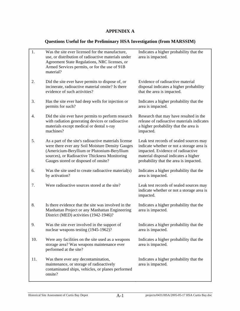
Historical Site Assessment of Curtis Bay Depot projects/0431/HSA/2005-05-17 HSA Curtis Bay.doc A-1
APPENDIX A
Questions Useful for the Preliminary HSA Investigation (from MARSSIM)
1. Was the site ever licensed for the manufacture, use, or distribution of radioactive materials under Agreement State Regulations, NRC licenses, or Armed Services permits, or for the use of 91B material?
Indicates a higher probability that the area is impacted.
2. Did the site ever have permits to dispose of, or incinerate, radioactive material onsite? Is there evidence of such activities?
Evidence of radioactive material disposal indicates a higher probability that the area is impacted.
3. Has the site ever had deep wells for injection or permits for such?
Indicates a higher probability that the area is impacted.
4. Did the site ever have permits to perform research with radiation generating devices or radioactive materials except medical or dental x-ray machines?
Research that may have resulted in the release of radioactive materials indicates a higher probability that the area is impacted.
5. As a part of the site's radioactive materials license were there ever any Soil Moisture Density Gauges (Americium-Beryllium or Plutonium-Beryllium sources), or Radioactive Thickness Monitoring Gauges stored or disposed of onsite?
Leak test records of sealed sources may indicate whether or not a storage area is impacted. Evidence of radioactive material disposal indicates a higher probability that the area is impacted.
6. Was the site used to create radioactive material(s) by activation?
Indicates a higher probability that the area is impacted.
7. Were radioactive sources stored at the site? Leak test records of sealed sources may indicate whether or not a storage area is impacted.
8. Is there evidence that the site was involved in the Manhattan Project or any Manhattan Engineering District (MED) activities (1942-1946)?
Indicates a higher probability that the area is impacted.
9. Was the site ever involved in the support of nuclear weapons testing (1945-1962)?
Indicates a higher probability that the area is impacted.
10. Were any facilities on the site used as a weapons storage area? Was weapons maintenance ever performed at the site?
Indicates a higher probability that the area is impacted.
11. Was there ever any decontamination, maintenance, or storage of radioactively contaminated ships, vehicles, or planes performed onsite?
Indicates a higher probability that the area is impacted.

Historical Site Assessment of Curtis Bay Depot projects/0431/HSA/2005-05-17 HSA Curtis Bay.doc A-2
12. Is there a record of any aircraft accident at or near the site (e.g., depleted uranium counterbalances, thorium alloys, radium dials)?
May include other considerations such as evidence of radioactive materials that were not recovered.
13. Was there ever any radiopharmaceutical manufacturing, storage, transfer, or disposal onsite?
Indicates a higher probability that the area is impacted.
14. Was animal research ever performed at the site? Evidence that radioactive materials were used for animal research indicates a higher probability that the area is impacted.
15. Were uranium, thorium, or radium compounds (NORM) used in manufacturing, research, or testing at the site, or were these compounds stored at the site?
Indicates a higher probability that the area is impacted or results in a potential increase in background variability.
16. Has the site ever been involved in the processing or production of Naturally Occurring Radioactive Material (e.g., radium, fertilizers, phosphorus compounds, vanadium compounds, refractory materials, or precious metals) or mining, milling, processing, or production of uranium?
Indicates a higher probability that the area is impacted or results in a potential increase in background variability.
17. Were coal or coal products used onsite? If yes, did combustion of these substances leave ash or ash residues onsite? If yes, are runoff or production ponds onsite?
May indicate other considerations such as a potential increase in background variability.
18. Was there ever any onsite disposal of material known to be high in naturally occurring radioactive materials (e.g., monazite sands used in sandblasting)?
May indicate other considerations such as a potential increase in background variability.
19. Did the site process pipe from the oil and gas industries?
Indicates a higher probability that the area is impacted or results in a potential increase in background variability.
20. Is there any reason to expect that the site may be contaminated with radioactive material (other than previously listed)?
See MARSSIM Section 3.6.3.

Historical Site Assessment of Curtis Bay Depot projects/0431/HSA/2005-05-17 HSA Curtis Bay.doc B-1
APPENDIX B
Building Conditions and Photographic Documentation
This appendix provides building conditions and photographs adapted from the draft Curtis Bay Depot Safe Entry Requirements for Phase 4 Radiological Surveys dated March 31, 2005. The information was prepared by Mark Baldwin, Bill Hermes, and Wayne Underwood of the Oak Ridge National Laboratory (ORNL) during building inspections performed February and March 2005 at the Curtis Bay Depot (CBD). The following table provides a legend for the condition identified for each building.
Condition Description
I Floor is generally free of debris and allows surface scanning by entry team, and building is generally assessed as being safe (structurally) to enter.
II
Floor is > 10 % covered by debris and requires pick-up/removal/consolidation prior to radiological team mobilization, with hazards evaluated and precautions implemented as necessary to avoid falling hazards and maintain radiological boundaries. Building is generally assessed as being safe (structurally) to enter.
III
Floor is generally free of debris and door access allows for use of long-handled tools and/or remote controlled robots for surface scanning by entry team from the door-way entrances. Building is not considered safe to enter.
NOTE: ORNL will consider supplying robotic components and operator under direction from ORAU; with condition all hardware/function is fully developed and tested prior to use on this project.
IV
Floor is generally clear except for localized roof cave-in(s), requiring a combination of methodologies above dependent on specific building zone condition and access. Specific buildings may or may not be considered safe to enter.
V
Floor is > 10 % covered by debris and requires heavy equipment utilization from the external building boundary prior to radiological team mobilization, with hazards evaluated and precautions implemented as necessary to avoid falling hazards and maintain radiological boundaries – deconstruct. Building is not considered safe to enter.
The following pages summarize the information for each building, using the above condition nomenclature.

BUILDING LISTING
PAGE B-
Historical Site Assessment of Curtis Bay Depot projects/0431/HSA/2005-05-17 HSA Curtis Bay.doc B-2
Building 305 ................................................................................................................................... 4
Building 404 ................................................................................................................................... 4
Building 821 ................................................................................................................................... 5
Building 822 ................................................................................................................................... 6
Building 823 ................................................................................................................................... 7
Building 825 ................................................................................................................................... 8
Building 1021 ................................................................................................................................. 9
Building 1022 ............................................................................................................................... 10
Building A-921 ............................................................................................................................. 11
Building A-922 ............................................................................................................................. 11
Building B-911 ............................................................................................................................. 12
Building B-912 ............................................................................................................................. 12
Building B-913 ............................................................................................................................. 13
Building C-1131 ........................................................................................................................... 13
Building C-1132 ........................................................................................................................... 14
Building C-1133 ........................................................................................................................... 14
Building C-1134 ........................................................................................................................... 15
Building D-1121 ........................................................................................................................... 16
Building D-1122 ........................................................................................................................... 17
Building D-1123 ........................................................................................................................... 18
Building D-1124 ........................................................................................................................... 19
Building D-1125 ........................................................................................................................... 19
Building E-1111............................................................................................................................ 20
Building E-1111 Update ............................................................................................................... 21
Building E-1112............................................................................................................................ 22
Building E-1113............................................................................................................................ 23
Building E-1114............................................................................................................................ 24
Building E-1115............................................................................................................................ 25
Building E-1116............................................................................................................................ 26
Building F-731.............................................................................................................................. 27

BUILDING LISTING
PAGE B-
Historical Site Assessment of Curtis Bay Depot projects/0431/HSA/2005-05-17 HSA Curtis Bay.doc B-3
Building F-732.............................................................................................................................. 28
Building F-733.............................................................................................................................. 29
Building F-734.............................................................................................................................. 30
Building F-735.............................................................................................................................. 31
Building F-736.............................................................................................................................. 32
Building F-737.............................................................................................................................. 33
Building G-721 ............................................................................................................................. 34
Building G-722 ............................................................................................................................. 35
Building G-723 ............................................................................................................................. 36
Building G-724 ............................................................................................................................. 37
Building G-725 ............................................................................................................................. 38
Building G-726 ............................................................................................................................. 39
Building H-711 ............................................................................................................................. 40
Building H-712 ............................................................................................................................. 41
Building H-713 ............................................................................................................................. 42
Building H-714 ............................................................................................................................. 43
Building H-715 ............................................................................................................................. 44
Building I-531............................................................................................................................... 45
Building I-631............................................................................................................................... 46
Building I-632............................................................................................................................... 47
Building I-633............................................................................................................................... 48
Building I-634............................................................................................................................... 49
Building I-636............................................................................................................................... 50
Building I-641............................................................................................................................... 51
Fuel Oil Building .......................................................................................................................... 52
Igloo .............................................................................................................................................. 53
Quonset Hut .................................................................................................................................. 54
Unknown Building Number.......................................................................................................... 55

Historical Site Assessment of Curtis Bay Depot projects/0431/HSA/2005-05-17 HSA Curtis Bay.doc B-4
BUILDING 305
CONDITION I
Notes:
“Admin. Bldg.” Dimensions: 47’ x 67’. Three floors (including “basement”).
Photographs:
BUILDING 404
CONDITION I
Notes:
“Scale House” Dimensions: 11’ x 15’
In use and ready for survey.
Photographs:
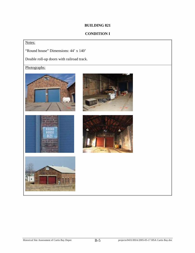
Historical Site Assessment of Curtis Bay Depot projects/0431/HSA/2005-05-17 HSA Curtis Bay.doc B-5
BUILDING 821
CONDITION I
Notes:
“Round house” Dimensions: 44’ x 140’
Double roll-up doors with railroad track.
Photographs:

Historical Site Assessment of Curtis Bay Depot projects/0431/HSA/2005-05-17 HSA Curtis Bay.doc B-6
BUILDING 822
CONDITION I
Notes:
“Machine Shop” Dimensions: 71’ x 40’ (with additional auto bay 17.5’ x 38.5’)
Photographs:

Historical Site Assessment of Curtis Bay Depot projects/0431/HSA/2005-05-17 HSA Curtis Bay.doc B-7
BUILDING 823
CONDITION I
Notes:
“Change House” Dimensions: 40’ x 90’
Photographs:

Historical Site Assessment of Curtis Bay Depot projects/0431/HSA/2005-05-17 HSA Curtis Bay.doc B-8
BUILDING 825
CONDITION I
Notes:
Dimensions: 39’ x 155’. Appears to be mostly empty and probably okay to enter and survey.
Photographs:

Historical Site Assessment of Curtis Bay Depot projects/0431/HSA/2005-05-17 HSA Curtis Bay.doc B-9
BUILDING 1021
CONDITION IV
Notes:
Dimensions: 240’ x 600’. Several collapsed roof areas, and roof structural problems, but these could be roped off (and accessed by pole mounted equipment, or robotic equipment). Not certain that power is off (but probably should be). Supplemental lighting would likely be needed for surveying. Some areas where roll-up doors previously existed are now filled with concrete block. Bird droppings in some areas.
Photographs:

Historical Site Assessment of Curtis Bay Depot projects/0431/HSA/2005-05-17 HSA Curtis Bay.doc B-10
BUILDING 1022
CONDITION IV
Notes:
Dimensions: 240’ x 600’. (less problems than in Building 1021) Some localized roof structural problems, but these could be roped off (and accessed by pole mounted or robotic equipment). A few small pre-fab. office areas might preclude access to some of the original floor surfaces. Sheet metal covering over exterior walls. Lighting – some working; some not. Would likely need supplemental lighting to conduct surveys.
Photographs:

Historical Site Assessment of Curtis Bay Depot projects/0431/HSA/2005-05-17 HSA Curtis Bay.doc B-11
BUILDING A-921
CONDITION I
Notes:
Dimensions: 50’ x 20’. Okay to survey. Building currently in use with power and lighting available.
DLA may need to relocate tractors and other equipment and materials to allow access to full area since this building was identified as having previously held radioactive materials (note: building was previously released by NRC).
Photographs:
BUILDING A-922
CONDITION I
Notes:
Dimensions: 50’ x 20’. Approximately 95% of floor area is clear. No power or lights.
Photographs:

Historical Site Assessment of Curtis Bay Depot projects/0431/HSA/2005-05-17 HSA Curtis Bay.doc B-12
BUILDING B-911
CONDITION I
Notes:
Dimensions: 50’ x 220’. Condition I by June 2005.
Photographs:
BUILDING B-912
CONDITION I
Notes:
Dimensions: 50’ x 220’. Condition I by June 2005.
Photographs:

Historical Site Assessment of Curtis Bay Depot projects/0431/HSA/2005-05-17 HSA Curtis Bay.doc B-13
BUILDING B-913
CONDITION I
Notes:
Dimensions: 50’ x 220’. Condition I by June 2005.
Photographs:
BUILDING C-1131
CONDITION I
Notes:
Dimensions: 50’ x 220’. A cleared slab. No road access (need to bush hog an access pathway).
Photographs:

Historical Site Assessment of Curtis Bay Depot projects/0431/HSA/2005-05-17 HSA Curtis Bay.doc B-14
BUILDING C-1132
CONDITION I
Notes:
Dimensions: 50’ x 220’. A cleared slab. No road access (may need to bush hog an access pathway).
Photographs:
BUILDING C-1133
CONDITION I
Notes:
Dimensions: 50’ x 220’. A cleared slab with a few small collapsed concrete areas. Dock elevation approx. 5’ (fall hazard). No road access (need to bush hog an access pathway).
Photographs:

Historical Site Assessment of Curtis Bay Depot projects/0431/HSA/2005-05-17 HSA Curtis Bay.doc B-15
BUILDING C-1134
CONDITION I
Notes:
Dimensions: 50’ x 220’. A slab with a grass covered dirt pile that covers 15-20% of slab area at the NW corner. Slab is collapsed at SE corner (approx. 20 to 25’ long by 3’ wide).
Photographs:

Historical Site Assessment of Curtis Bay Depot projects/0431/HSA/2005-05-17 HSA Curtis Bay.doc B-16
BUILDING D-1121
CONDITION V
Notes:
All roofing has collapsed, with debris covering slab. Several portions of wall are down, and stability of remaining walls is questionable. No road access (may need to bush hog an access pathway).
Photographs:

Historical Site Assessment of Curtis Bay Depot projects/0431/HSA/2005-05-17 HSA Curtis Bay.doc B-17
BUILDING D-1122
CONDITION I
Notes:
A cleared slab. South and west sides have elevation (fall) hazard ~ 6’. No road access (may need to bush hog an access pathway).
Photographs:

Historical Site Assessment of Curtis Bay Depot projects/0431/HSA/2005-05-17 HSA Curtis Bay.doc B-18
BUILDING D-1123
CONDITION III
Notes:
Nearly no debris on floor. Use pole-mounted or robotic equipment. Door 5 and surrounding area collapsed. South wall fallen outward. Early form of “concertina” razor wire on ground along west and north walls. Loose roof shingles – some blown 20-30 ft from building. No road access (may need to bush hog an access pathway).
Photographs:

Historical Site Assessment of Curtis Bay Depot projects/0431/HSA/2005-05-17 HSA Curtis Bay.doc B-19
BUILDING D-1124
CONDITION I
Notes:
A cleared slab with a collapsed concrete area at NE corner (approx. 8’ x 2’). No road access (may need to bush hog an access pathway).
Photographs:
BUILDING D-1125
CONDITION I
Notes:
A cleared slab with a collapsed concrete area at NE corner (approx. 8’ x 2’). No road access (may need to bush hog an access pathway).
Photographs:

Historical Site Assessment of Curtis Bay Depot projects/0431/HSA/2005-05-17 HSA Curtis Bay.doc B-20
BUILDING E-1111
CONDITION II OR IV
Notes:
Condition depends on amount of area required to survey to release this building. Wall buckling at north end of door 5 and roof truss is broken (supported by pyramid stack of railroad ties inside building). Remain out of this area. 60-70% of floor is accessible. Entry is okay for door 4 and points north (and can use poles or robotic equipment for areas south of this point). Stay back from stacked drums (at least a distance equal to height of drums). Power and lights available.
Photographs:

Historical Site Assessment of Curtis Bay Depot projects/0431/HSA/2005-05-17 HSA Curtis Bay.doc B-21
BUILDING E-1111 UPDATE
Notes:
ORNL provided an update on the condition of Building E-1111 on April 27, 2005. Refer to the photograph annotations below.
Photographs:

Historical Site Assessment of Curtis Bay Depot projects/0431/HSA/2005-05-17 HSA Curtis Bay.doc B-22
BUILDING E-1112
CONDITION I
Notes:
A cleared slab. Elevation (fall) hazard - greater than 4’ drop on several sides.
Photographs:

Historical Site Assessment of Curtis Bay Depot projects/0431/HSA/2005-05-17 HSA Curtis Bay.doc B-23
BUILDING E-1113
CONDITION V
Notes:
Very little roof left. No clear floor area. A few trusses standing. Loose gutter, and loose masonry at top of walls. No road access (may need to bush hog an access pathway).
Photographs:

Historical Site Assessment of Curtis Bay Depot projects/0431/HSA/2005-05-17 HSA Curtis Bay.doc B-24
BUILDING E-1114
CONDITION V
Notes:
Approximately 50% of roof collapsed. Approximately 90-95% of floor covered by roofing debris. Possibly access area of cleared concrete floor on west side, by using pole mounted survey equipment through holes in wall. Most trusses still in place. Loose guttering. Door 2 not useable. No road access (may need to bush hog an access pathway).
Photographs:

Historical Site Assessment of Curtis Bay Depot projects/0431/HSA/2005-05-17 HSA Curtis Bay.doc B-25
BUILDING E-1115
CONDITION V
Notes:
Small section of east wall is only wall still standing. North wall fallen outward. Most of east wall fallen outward onto dock. No clear floor areas (roofing material and two stacks of pallets cover floor). No road access. Need to bush hog an access pathway, or pull up railroad ties and use area as a road).
Photographs:

Historical Site Assessment of Curtis Bay Depot projects/0431/HSA/2005-05-17 HSA Curtis Bay.doc B-26
BUILDING E-1116
CONDITION I
Notes:
A cleared slab.
Photographs:

Historical Site Assessment of Curtis Bay Depot projects/0431/HSA/2005-05-17 HSA Curtis Bay.doc B-27
BUILDING F-731
CONDITION II
Notes:
Dimensions: 50’ x 220’. Need to move pallets of drums to access floor for surveys. Okay for entry. Drums (empty) are stacked on south end (4 pallets deep by 9 pallets long, by up to 4 pallets high). Floor has several areas where the concrete was previously scabbled for decon purposes. Roof hole above drum storage area.
Photographs:

Historical Site Assessment of Curtis Bay Depot projects/0431/HSA/2005-05-17 HSA Curtis Bay.doc B-28
BUILDING F-732
CONDITION V
Notes:
Dimensions: 50’ x 220’. Most of roof collapsed and on floor (lots of debris). Remove rest of roof, and drag out debris to provide areas to survey.
Photographs:

Historical Site Assessment of Curtis Bay Depot projects/0431/HSA/2005-05-17 HSA Curtis Bay.doc B-29
BUILDING F-733
CONDITION I
Notes:
A cleared slab.
Photographs:

Historical Site Assessment of Curtis Bay Depot projects/0431/HSA/2005-05-17 HSA Curtis Bay.doc B-30
BUILDING F-734
CONDITION V
Notes:
Dimensions: 50’ x 220’. 2/5 of roof has collapsed; the rest has holes. Only portions of walls are standing. Remaining portion of roof and remaining portions of walls should be taken down. While some areas of the floor are clear, metal shelving and roofing debris block access to other portions of floor.
Photographs:

Historical Site Assessment of Curtis Bay Depot projects/0431/HSA/2005-05-17 HSA Curtis Bay.doc B-31
BUILDING F-735
CONDITION V
Notes:
Dimensions: 50’ x 220’. 20 to 25’ section of building totally collapsed (near north end). A portion was intentionally knocked down in early 2005 (after a roof collapse) to allow access to retrieve some transformers. Remaining portions of roof should be taken down. This building has poured concrete dikes. Pallets and other items cover portions of the floor.
Photographs:
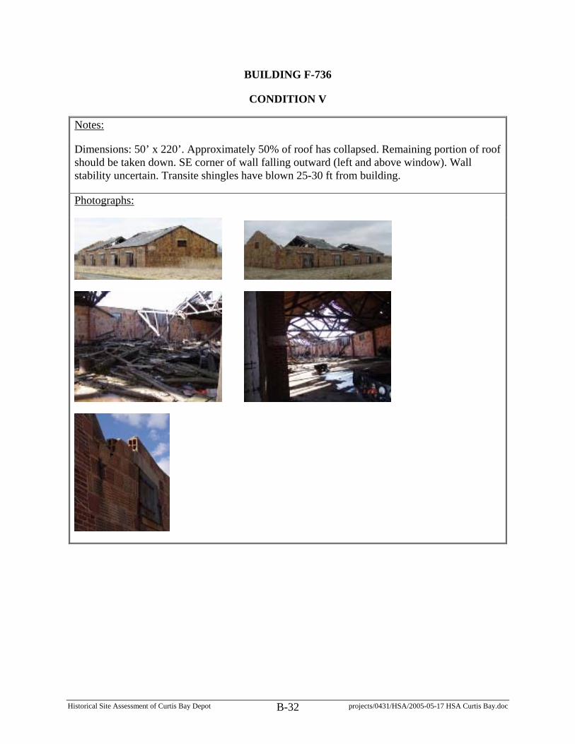
Historical Site Assessment of Curtis Bay Depot projects/0431/HSA/2005-05-17 HSA Curtis Bay.doc B-32
BUILDING F-736
CONDITION V
Notes:
Dimensions: 50’ x 220’. Approximately 50% of roof has collapsed. Remaining portion of roof should be taken down. SE corner of wall falling outward (left and above window). Wall stability uncertain. Transite shingles have blown 25-30 ft from building.
Photographs:

Historical Site Assessment of Curtis Bay Depot projects/0431/HSA/2005-05-17 HSA Curtis Bay.doc B-33
BUILDING F-737
CONDITION I
Notes:
Dimensions: 50’ x 220’. A cleared slab with several collapsed areas (4’ to 8’ by 4’ to 6’ deep).
Photographs:

Historical Site Assessment of Curtis Bay Depot projects/0431/HSA/2005-05-17 HSA Curtis Bay.doc B-34
BUILDING G-721
CONDITION I
Notes:
A cleared slab (dock has collapsed in several places).
Photographs:

Historical Site Assessment of Curtis Bay Depot projects/0431/HSA/2005-05-17 HSA Curtis Bay.doc B-35
BUILDING G-722
CONDITION V
Notes:
All of north wall is down. North end of east wall is down. North half of roof is down. Large section of brick pillar “perched” half off loading dock. Lots of roof debris on concrete floor. Some metal shelving, tables, on south end. One bay has some clear areas for possible survey by pole or robotic equipment.
Photographs:
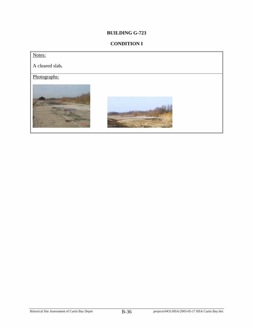
Historical Site Assessment of Curtis Bay Depot projects/0431/HSA/2005-05-17 HSA Curtis Bay.doc B-36
BUILDING G-723
CONDITION I
Notes:
A cleared slab.
Photographs:

Historical Site Assessment of Curtis Bay Depot projects/0431/HSA/2005-05-17 HSA Curtis Bay.doc B-37
BUILDING G-724
CONDITION III OR V
Notes:
South end of roof is down. Roof hole in NW corner; and other roof deterioration areas. Door 5 (south end) is a sliding door and is shut (stuck?). Door 4 is slightly open. Floor is clear except at south end. Possibly access cleared areas by pole or robotic equipment. Heavy shingles could come off towards dock.
Photographs:

Historical Site Assessment of Curtis Bay Depot projects/0431/HSA/2005-05-17 HSA Curtis Bay.doc B-38
BUILDING G-725
CONDITION I
Notes:
A cleared slab.
Photographs:

Historical Site Assessment of Curtis Bay Depot projects/0431/HSA/2005-05-17 HSA Curtis Bay.doc B-39
BUILDING G-726
CONDITION III OR V
Notes:
South end of roof is down (with roofing debris on floor). Roof overall is poor. Several areas of cleared floor. Possibly access these areas for survey by pole or robotic equipment. Some concern for potential of heavy shingles that could come off towards dock.
Photographs:

Historical Site Assessment of Curtis Bay Depot projects/0431/HSA/2005-05-17 HSA Curtis Bay.doc B-40
BUILDING H-711
CONDITION III
Notes:
Dimensions: 32’x 95’. Condition could possibly be changed to V after phase A. Roof hole at NW corner. Roof condition uncertain. Furniture and some other items on an otherwise clear wooden floor. Doors completely off south end of dock. Use pole-mounted survey equipment or robotic equipment. There is a crawl space under this building.
Photographs:

Historical Site Assessment of Curtis Bay Depot projects/0431/HSA/2005-05-17 HSA Curtis Bay.doc B-41
BUILDING H-712
CONDITION III
Notes:
Dimensions: 32’x 95’. Condition could possibly be changed to V after phase A. 70-80% of wooden floor intact. Roof and ceiling collapsed at north and south ends. Doors at south end of dock – no access. Doors at north end of dock – left hand door is down, right hand door is hanging. Dock is in rough condition on extreme south end. There is a crawl space under this building.
Photographs:

Historical Site Assessment of Curtis Bay Depot projects/0431/HSA/2005-05-17 HSA Curtis Bay.doc B-42
BUILDING H-713
CONDITION III
Notes:
Dimensions: 32’x 95’. Condition could possibly be changed to V after phase A. Roof and ceiling collapsed at NW and SE corners. 70-80% of wooden floor intact. Floor holes in some areas, including at least one where the roof support column has collapsed through floor. Doors at south end of dock – right hand door is hanging and could fall (secure in place or remove). Dock – elevation hazard (greater than 4’). There is a crawl space under this building.
Photographs:

Historical Site Assessment of Curtis Bay Depot projects/0431/HSA/2005-05-17 HSA Curtis Bay.doc B-43
BUILDING H-714
CONDITION V
Notes:
Dimensions: 32’x 95’. Ceiling and roof collapsed and debris covers wooden floor. There is a crawl space under this building (and roof, ceiling, and floor debris has fallen into some areas of the crawl space). Radiation signs on doors.
Photographs:

Historical Site Assessment of Curtis Bay Depot projects/0431/HSA/2005-05-17 HSA Curtis Bay.doc B-44
BUILDING H-715
CONDITION V
Notes:
Dimensions: approximately 32’x 95’. Deconstruction may be complicated by the high berm on three sides which restricts equipment access to area. Roof and ceiling collapsed, and debris covers floor.
Photographs:

Historical Site Assessment of Curtis Bay Depot projects/0431/HSA/2005-05-17 HSA Curtis Bay.doc B-45
BUILDING I-531
CONDITION III
Notes:
Dimensions are similar to an “H” building. Condition could possibly be changed to V after phase A. Roof collapsed at SW corner. Approximately 70% of floor still intact. Ceiling low. Could use pole-mounted survey equipment or robotic equipment (from doorways). Brick and terra cotta block.
Photographs:

Historical Site Assessment of Curtis Bay Depot projects/0431/HSA/2005-05-17 HSA Curtis Bay.doc B-46
BUILDING I-631
CONDITION V
Notes:
Dimensions are similar to an “H” building. Majority of roof collapsed and debris covers wooden floor. Very minimal access at the south end of the dock (door stuck with only ~6” opening). No worthwhile access from north end of dock. Gutters loose at north and NE areas.
Photographs:

Historical Site Assessment of Curtis Bay Depot projects/0431/HSA/2005-05-17 HSA Curtis Bay.doc B-47
BUILDING I-632
CONDITION V
Notes:
Dimensions are similar to an “H” building. No access through doors at north end of dock (roofing debris covers floor area and door way). Some floor accessible from south end of dock (for pole-mounted or robotic survey equipment). Noted several large chips of brick have fallen, and continuing chips would be a head hazard.
Photographs:

Historical Site Assessment of Curtis Bay Depot projects/0431/HSA/2005-05-17 HSA Curtis Bay.doc B-48
BUILDING I-633
CONDITION III
Notes:
Dimensions are similar to an “H” building. Condition could possibly be changed to V after phase A. Portions of roof collapsed onto wooden floor (lots of debris on south end). North end – considerable floor accessible by pole from door. Approximately 5’ wide clear aisle along east wall (for pole-mounted survey equipment access). [Accessed from south end of dock] Doors at north end of dock – right door down, left door hanging badly (brace or remove).
Photographs:
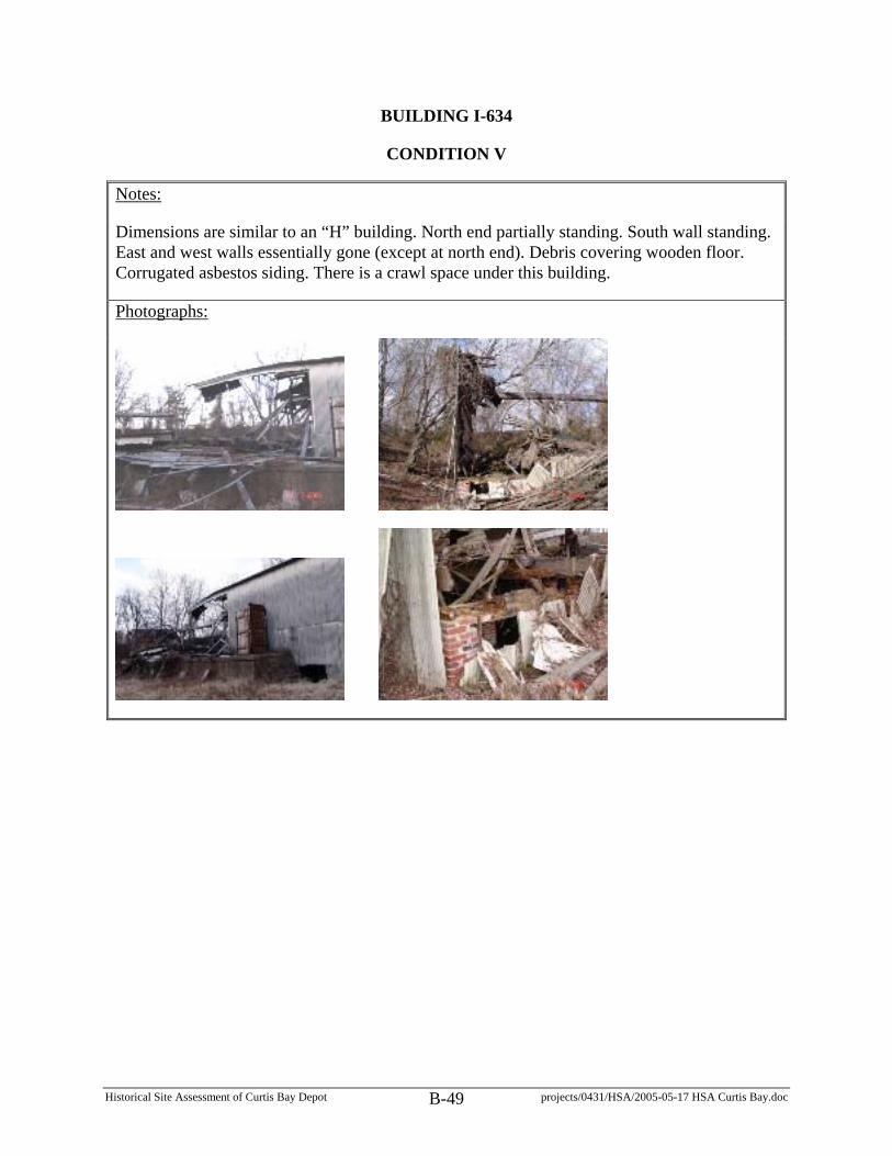
Historical Site Assessment of Curtis Bay Depot projects/0431/HSA/2005-05-17 HSA Curtis Bay.doc B-49
BUILDING I-634
CONDITION V
Notes:
Dimensions are similar to an “H” building. North end partially standing. South wall standing. East and west walls essentially gone (except at north end). Debris covering wooden floor. Corrugated asbestos siding. There is a crawl space under this building.
Photographs:
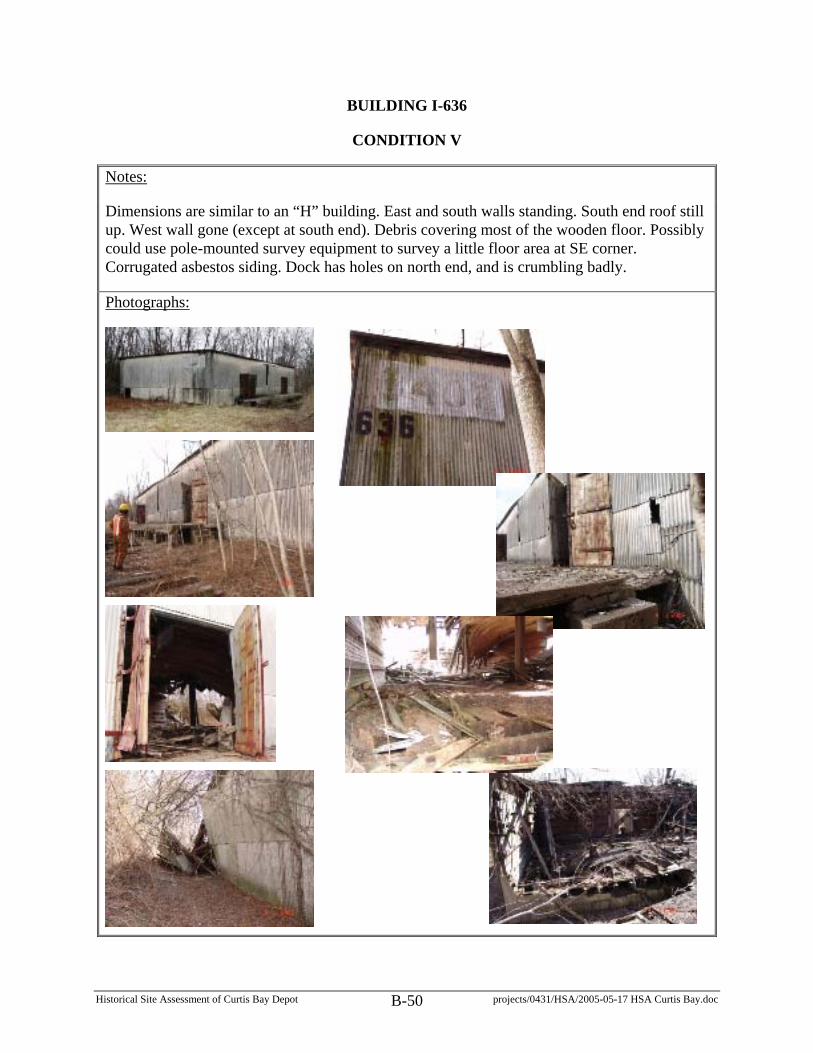
Historical Site Assessment of Curtis Bay Depot projects/0431/HSA/2005-05-17 HSA Curtis Bay.doc B-50
BUILDING I-636
CONDITION V
Notes:
Dimensions are similar to an “H” building. East and south walls standing. South end roof still up. West wall gone (except at south end). Debris covering most of the wooden floor. Possibly could use pole-mounted survey equipment to survey a little floor area at SE corner. Corrugated asbestos siding. Dock has holes on north end, and is crumbling badly.
Photographs:

Historical Site Assessment of Curtis Bay Depot projects/0431/HSA/2005-05-17 HSA Curtis Bay.doc B-51
BUILDING I-641
CONDITION V
Notes:
Dimensions are similar to an “H” building. North wall partially leaning inward. Partial roof on north end. Stay away from west wall (could fall outward). West wall (south end) collapsed. East and south walls still standing. Doors on south end of dock are stuck (barely open). There is a crawl space under this building. Corrugated asbestos siding.
Photographs:

Historical Site Assessment of Curtis Bay Depot projects/0431/HSA/2005-05-17 HSA Curtis Bay.doc B-52
FUEL OIL BUILDING
CONDITION I
Notes:
Dimensions 15’ x 25’. Located south of Building 825. Unguarded perimeter walkway around pit w/tank.
Photographs:

Historical Site Assessment of Curtis Bay Depot projects/0431/HSA/2005-05-17 HSA Curtis Bay.doc B-53
IGLOO
CONDITION NOT SPECIFIED
Notes:
Located west of G-726. Concrete igloo shaped structure embedded in what would otherwise look like a long berm. Open vent pipe at top. Clear floor.
Photographs:

Historical Site Assessment of Curtis Bay Depot projects/0431/HSA/2005-05-17 HSA Curtis Bay.doc B-54
QUONSET HUT
CONDITION NOT SPECIFIED
Notes:
Located between bermed area SW of G-726. Collapsed corrugated metal structure.
Photographs:

Historical Site Assessment of Curtis Bay Depot projects/0431/HSA/2005-05-17 HSA Curtis Bay.doc B-55
UNKNOWN BUILDING NUMBER
CONDITION III
Notes:
Dimensions: 25’ x 35’. Building is located west of Buildings 1021 and 1022. Concrete walls and roof. Recommend surveying from doorway.
Photographs: