Historical predecessors and current geographical possibilities of ...
39
Károly Kocsis Historical predecessors and current geographical possibilities of ethnic based territorial autonomies in the Carpathian Basin e ideal of the builders of the 19th century nation states, the idea of ’one state – one na- tion’ has not come into existence in hardly any of the European states despite the ethnic cleansings, forced migrations, forced assimilation and partly as a result of the mass appear- ance of immigrants (e.g. “Gastarbeiter/guest workers”, refugees). From among the present 703 million inhabitants of our continent, members of titular nations of the individual countries constitute only 85%, historic national and ethnic minorities constitute 10%, while the remaining 5% are immigrants with no citizenship. According to census data, from among the European states (except for the micro states) Poland, Portugal, Hungary, the Netherlands, the Czech Republic and Norway are the closest to the above mentioned nation state homogeneity, where more than 93% of the population count as members of the titular nation. From an ethnic-linguistic perspective (except for Belgium, Bosnia, Cyprus and Switzerland, as well as the micro states that all have unique ethnic-political backgrounds) the most heterogeneous ones are Spain, Latvia and Macedonia, since in their case the joint proportion of minorities exceed one third of the population. Due to this significant and in some cases increasing ethnic-linguistic diversity, the fading of the memories of the second world war and the dissolution of the former Com- munist federal states the number and intensity of the ethnic conflicts within the states has increased since the 1960s. In the background of the conflicts a rigid rejection of the collective rights of minorities (including those related to autonomy) and, as a result, the secessionist ambitions of the minorities could be observed in most of the cases. Follow- ing the civil wars on the territories of the former Yugoslavia and the Soviet Union in the 1990s, efforts were made to settle such conflicts peacefully, via negotiations, moreover, in the case of certain western nation states that had earlier been strictly centralised, de- centralization, and a movement towards regional self-governance could be observed. 1 From among the states possessing solid democratic traditions, acknowledging territori- al and cultural heterogeneity seeking to avoid conflict, primarily Italy, Spain, Belgium and the United Kingdom pursued the deepening of the various forms of regional pow- er-sharing, the most common one of which, along with the system of federal and asso- ciated statehood, is autonomy. Autonomy can be of non-ethnic (regional territorial) and of ethnic nature. e status of Spain and that of some Italian autonomous regions 1 Benedikter, T.: e World’s Modern Autonomy Systems. Concepts and Experiences of Regional Territorial Autonomy. Bolzano: Institute of Minority Rights EURAC Research. 2009.
Transcript of Historical predecessors and current geographical possibilities of ...

Károly Kocsis
Historical predecessors and current geographical possibilities of ethnic based territorial autonomies in the Carpathian Basin
The ideal of the builders of the 19th century nation states, the idea of ’one state – one na-tion’ has not come into existence in hardly any of the European states despite the ethnic cleansings, forced migrations, forced assimilation and partly as a result of the mass appear-ance of immigrants (e.g. “Gastarbeiter/guest workers”, refugees). From among the present 703 million inhabitants of our continent, members of titular nations of the individual countries constitute only 85%, historic national and ethnic minorities constitute 10%, while the remaining 5% are immigrants with no citizenship. According to census data, from among the European states (except for the micro states) Poland, Portugal, Hungary, the Netherlands, the Czech Republic and Norway are the closest to the above mentioned nation state homogeneity, where more than 93% of the population count as members of the titular nation. From an ethnic-linguistic perspective (except for Belgium, Bosnia, Cyprus and Switzerland, as well as the micro states that all have unique ethnic-political backgrounds) the most heterogeneous ones are Spain, Latvia and Macedonia, since in their case the joint proportion of minorities exceed one third of the population.
Due to this significant and in some cases increasing ethnic-linguistic diversity, the fading of the memories of the second world war and the dissolution of the former Com-munist federal states the number and intensity of the ethnic conflicts within the states has increased since the 1960s. In the background of the conflicts a rigid rejection of the collective rights of minorities (including those related to autonomy) and, as a result, the secessionist ambitions of the minorities could be observed in most of the cases. Follow-ing the civil wars on the territories of the former Yugoslavia and the Soviet Union in the 1990s, efforts were made to settle such conflicts peacefully, via negotiations, moreover, in the case of certain western nation states that had earlier been strictly centralised, de-centralization, and a movement towards regional self-governance could be observed.1 From among the states possessing solid democratic traditions, acknowledging territori-al and cultural heterogeneity seeking to avoid conflict, primarily Italy, Spain, Belgium and the United Kingdom pursued the deepening of the various forms of regional pow-er-sharing, the most common one of which, along with the system of federal and asso-ciated statehood, is autonomy. Autonomy can be of non-ethnic (regional territorial) and of ethnic nature. The status of Spain and that of some Italian autonomous regions
1 Benedikter, T.: The World’s Modern Autonomy Systems. Concepts and Experiences of Regional Territorial Autonomy. Bolzano: Institute of Minority Rights EURAC Research. 2009.

84 Károly Kocsis
not populated by minorities (e.g. Andalusia, Madrid, Sicily) stand as examples for the former one. The latter, the ethnic based autonomy (if ethnic-geographical conditions are met) may be territorial (e.g. South Tyrol, Åland Islands, Catalonia, Tatarstan) or local (administrative) and personal (cultural).2
“A territorial autonomy is a geographically defined area, which differs from other sub-regions (like municipalities, federal states, etc.) in a specific country and has re-ceived special status with legislative and/or regulatory (administrative) powers”.3 In the past such form of autonomy was considered to be the first step towards separation, a means to disintegrate existing states.4 Today, based on positive international experienc-es, we believe that territorial autonomy is the most developed asset of minority protec-tion and the most modern form of internal self-governance, which can be considered as a compromise between the given state (the titular nation) and the national minorities, which ensures autonomy – a fundamental human right – to the minorities and ensures the preservation of the territorial integrity and the intangibility of the borders to the state.
In order to preserve the state’s territorial integrity and to grant the minority collec-tive rights (voluntarily or under compulsion), territorial autonomies have so far been realised in Europe primarily on Scandinavian, Italian, Spanish and British territories and in Russia (Figure 15). It is conspicuous, however, that on the territory of France, the ideal of the strongly centralised nation states, and on the territories of the ex-commu-
2 Benedikter, T.: The World’s Modern Autonomy Systems, op. cit.3 Ackrén, M.: Conditions for Different Autonomy Regimes in the World. Åb: Åbo Akademi University Press, 2009. 20.4 Pan, C. and Pfeil, B.S.: National Minorities in Europe: Handbook, Vol. 1. Vienna: Braumüller ETHNOS. 20035 Fig.1. Existing and geographically possible ethnic based territorial autonomies in Europe
Fig.1. Existing and geographically possible ethnic based territorial autonomies in Europe

85Historical predecessors and current geographical possibilities
nist East-Central and South-Eastern European countries, such autonomies – because of the fear of the suspected secessionist endeavours of the minorities – could not be realised.
As shown by international experiences, an ethnic based territorial autonomy (dis-regarding the political conditions this time and concentrating on a pure ethnic-geo-graphical aspect) can only be successful, where the ethnic area of the given minority is (more or less) contiguous and where the ethnic minority constitutes the absolute (demographic) majority (that is in the area the members of the titular nation represent a demographic minority). From this respect, in France Alsace (German speaking Alsa-tians), Lower Brittany (Bretons), the Northern Basque Country, Northern Catalonia/Roussillon and Corsica should have this form of self-governance. The same is true for some minorities living in the ex-communist countries (e.g. Poles in the joint border are-as of Lithuania and Belarus, Turks in Bulgaria, Bulgarians in Serbia and in the Ukraine, Serbs in Northern Kosovo, Bosniaks/Muslims in the Serbian Sandjak area, and the Hungarians in the Carpathian Basin).
Historical roots of the territorial autonomies in the Carpathian Basin
The Carpathian Basin, accommodating almost 29 million inhabitants, has a situation similar to the European average, since 84% of its inhabitants are members of the indi-vidual titular nation. From among the other inhabitants who count fundamentally as na-tional-ethnic minorities, due to state borders drawn after the two world wars and due to migration processes, it is only the Hungarian minority (to be more precise, only two third of them) who possesses a settlement area which meets the prerequisites of a territorial autonomy. All other minorities basically fight for survival on linguistic islands and in di-asporas, where the only possibility is to realise local or cultural autonomy.
The period before 1918
It is a little-known fact that the Carpathian Basin can be called the cradle of European territorial autonomies, where the individual regions and ethnic groups had a large scope of autonomy until the middle of the 19th century.
In the Carpathian Basin, Croatia – which had become part of the Hungarian King-dom between 1091 and 1097 as a result of the military campaigns led by the Hun-garian kings Saint Ladislaus I and Coloman I – had the longest (lasting almost 800 years) regional territorial self-governance, which preserved its territorial separatism, its self-governance in the form of a personal union as regulated by the pact of 1102 (Pacta conventa) between King Coloman and the Croatian aristocracy during the existence of the Hungarian-Croatian state. This territorial separatism and self-governance were also represented by the ban (viceroy) of Croatia-Dalmatia and Slavonia and their national assembly (sabor). Slavonia (Hung. Tótország, Szlavónország) between the Drava river

86 Károly Kocsis
and the Dinaric Ranges permanently became a part of Hungary at the beginning of the 11th century and the foundation of the diocese of Zagreb by Saint Ladislaus I in 1091, and was ruled as a duchy by heirs to the throne and other members of the royal family or the bans of Slavonia from the 12th century (Figure 26).
The different degrees of autonomies of Croatia and Slavonia decreased significantly after 1526 under the Habsburg rule and their territories were reduced to approximately to one third of their original size after the Ottoman (Turkish) invasion. Consequently and as a result of the large-scale migration the centre of the Croatian statehood (and the notion of Croatia) was pushed from the seaside to the northern, Slavonian territories near Zagreb, while the notion of Slavonia was pushed towards the east, to the territories between the Drava and Sava rivers, reconquered from the Ottoman Empire between 1684 and 1688.7 After 1790 Slavonia is mentioned together with Croatia, as one of its parts. During the Hungarian revolution and war of independence in 1848, the consti-tutional law relations were discontinued to be only restored in 1868 with the Croa-to–Hungarian Compromise, which again recognised the Kingdom of Croatia-Slavonia
6 Fig. 2. Territorial autonomies in the countries of the Hungarian Crown (1500). – 1 = Cuman (Kun) seats; 2 = Jassic ( Jász) seat ( Jazygia); 3 = Saxon seats in Transylvania; 4 = Saxon XVI towns (pawned to Poland); 5 = Saxon XI towns (in Hungarian Zips, Szepes, Spiš); 6 = Sedes X lanceatorum; 7 = Székely seats
7 Szabó, P. Z.: Horvátország és mai részei a magyar történelemben (Croatia and actual parts in the Hungarian history). Földrajzi Zsebkönyv, Budapest: Magyar Földrajzi Társaság, 1945. 210–233.
Fig. 2. Territorial autonomies in the countries of the Hungarian Crown (1500). – 1 = Cuman (Kun) seats; 2 = Jassic ( Jász) seat ( Jazygia); 3 = Saxon seats in Transylvania; 4 = Saxon XVI towns (pawned to Poland); 5 = Saxon XI towns (in Hungarian Zips, Szepes, Spiš); 6 = Sedes X lanceatorum; 7 = Székely seats

87Historical predecessors and current geographical possibilities
as a part of the Holy Crown of Hungary with wide autonomy. This commonwealth of states, that is the territorial autonomy within the Hungarian state was terminated by the Croatian Parliament after the fall of the Austro–Hungarian Monarchy, on 29 October 1918 and it joined the new born state (Kingdom of Serbs, Croats and Slo-venes, Yugoslavia) later, within the framework of which it could only enjoy the same degree of internal independence that had been established in the Croatian–Hungarian commonwealth of states significantly later (1939–1941, 1974–1991). In today’s terms the self-governance of Croatia and Slavonia in the Hungarian state could formally be conceived as a regional territorial autonomy, however, with respect to the fact that the majority of their population was South Slav (until the middle of the 16th century al-most the entire population was Catholic South Slav: Slavonian and Croatian), the in-ternal independence of these territories can be understood as an ethnic based territorial autonomy.
Transylvania (Hung. Erdély, Rom. Ardeal, Germ. Siebenbürgen) frequently embod-ied the different degrees of regional territorial autonomy during the first millennium of the Hungarian statehood, primarily because of its large distance from the core area of the state (Esztergom, Buda, Visegrád, Székesfehérvár) and because of its unique ge-ographical location.8 From the 11th century the representative of the Hungarian king, named mercurius princeps, and later voivode, ensured the province a regional territorial autonomy to varying degrees, always reflecting the strength of the central power. Fol-lowing the battle of Mohács (1526) the voivodship of Transylvania became the main territory of the Eastern Hungarian Kingdom ruled by John Szapolyai (former voivode, now King John I). Later, as agreed in the Treaty of Speyer (1570), in the following century it ensured the survival of the concept of an independent Hungarian statehood (theoretically as an inalienable part of the Hungarian Kingdom) ‘only’ as a principality. From 1541 this Hungarian state, which counted as an Ottoman vassal, had an extraor-dinarily wide range of regional territorial autonomy, even a minimally suppressed sov-ereignty within the Ottoman Empire. This relative independence ceased to exist after expulsion of the Turks.
As a consequence of the Diploma Leopoldinum issued by Emperor Leopold I in 1691, Transylvania became a province of the Habsburg Empire as a country of the Hun-garian Crown and with a Hungarian public law status, but with its own statehood as a principality, and as a grand principality after 1765. After this, Transylvania and Hun-gary were first legally reunited by Act 7 of the Law of 1848, and later, after the Austro–Hungarian Compromise by Act 18 of the Law of 1868. As a result of the latter one the relative territorial independence of Transylvania – which continued to exist within the Hungarian state from the Middle Ages – was permanently eliminated in accordance with the goals aimed to be achieved by the united Hungarian nation state.
In the Middle Ages, the Hungarian rulers granted collective self-governance rights prevailing over the whole community and confined to a certain territory, occasionally for periods of centuries to numerous ethnic communities and social groups who were
8 Kristó, Gy.: Early Transylvania (895–1324). Budapest: Lucidus. 2003.

88 Károly Kocsis
settled on their estates in exchange for their military service. The majority of such priv-ileges were equal to what today we define as ethnic based territorial autonomies. The document that is the first one granting such rights in Europe is the charter issued by Andrew II of Hungary in 1224 (Andreanum), which granted the Transylvanian Saxons territorial based collective rights.9
The autonomous region of the German settlers called Saxon was established in South Transylvania with its seat in Hermannstadt (Szeben, Sibiu) from the second half of the 12th century. The „Saxons” gradually settled in for the defence of the South Transylvanian border that had been under threat from the attacks of the regular heavy-armed Byzantine troops in the 12–14th century to replace the light cavalry Székely border guard population transplanted to Eastern Carpathians. Apart from the rights typical for territorial autonomies, the larger Saxon settlements were granted market and staple rights, which resulted in an accelerated urbanisation on their territories from the 14th century. The Saxon autonomy in Transylvania became territorially complete in 1486, when king Matthias Corvinus expanded their privileges included in the Andrea-num to the entire Transylvanian Saxon ethnic territory (Königsboden, Nösnerland, Burzenland), thus establishing the autonomous territorial unit, “Saxonian University” (Universitas Saxonum).10 From the time of the Reformation, the Saxons did not only separate from their surroundings as regards their territory, but also their (Lutheran) confession. Their territorial autonomy ceased temporarily between 1785–1791 and 1852–1860, and finally permanently as a result of the public administration reform of 1876 (Act 33).
A territorial autonomy similar to the one of the Transylvanian Saxons’ was enjoyed for longer than 600 years by the majority of the Zipser Saxons (Germans) settled from the 12th century to the feet of the High Tatra mountains into the valley of the rivers Poprad and Hernád (Hornád). Their privileges were affirmed by Stephen V in 1271 and he also declared their territory to be a closed autonomous province, independent of the county, with Leutschau (Lőcse, Levoča) as its seat (universitas seu provincia Sax-onum de Scepus).11 Their customary law was affirmed and codified by Louis I (Great) in 1370 (Zipser Willkür). 13 out of the 24 towns of Zips (Szepes, Spiš) were pawned to Poland in 1412 by King Sigismund, where their autonomy continued to exist until its 1770 (1772) reannexation.12 While the remaining 11 Saxon towns that were not pawned gradually came under the rule of the county, the ones who returned in 1770 – and were joined by Altlublau (Ólubló, Stara Lubovňa), Pudlein (Podolin, Podolinec)
9 Érszegi, G.: The Andreanum. The first known legal framework of regional self-administration, SENCE. Budapest, J. v. Komlossy. 2004. 204.
10 Müller, G.E.: Die sächsische Nationsuniversität. Verein für Siebenbürgische Landeskunde. Hermannstadt. 1928., Hanzó, L.: Az erdélyi szász önkormányzat kialakulása (Formation of the Transylvanian Saxon autonomy). In Értekezések a M. Kir. Horthy Miklós Tudományegyetem Magyar Történelmi Intézetéből, Szeged. 1941.
11 Fekete Nagy, A.: A Szepesség területi és társadalmi kialakulása (Territorial and social formation of Szepes [(Zips, Spiš] county). Budapest. 1934.
12 Žudel, J.: Stolice na Slovensku (Counties on the present-day territory of Slovakia). Bratislava: OBZOR. 1984.

89Historical predecessors and current geographical possibilities
and Kniesen (Gnézda, Hniezdne) – could preserve their autonomy until as late as 1876 under the name Province of 16 Zips (Szepes, Spiš) towns.
In connection with the Zips area, one of Hungary’s oldest autonomies, the ‘Sedes X lanceatorum’ (county of the ten lance-bearers), needs to be mentioned. The privileg-es of its border guard inhabitants were affirmed by Béla IV in 1243.13 From the 16th century the population of the territory had a Slovakian majority. Later, its more than six-century long autonomy ceased in 1802 when it was merged into the county of Zips (Szepes, Spiš).
In the 12th and 13th centuries there was a close correlation between the settling in of the above-mentioned Transylvanian Saxons and the migration of the border guard Székely population, and the subsequent creation of their autonomous territories, what later became Székely Land (Székelyföld, Szeklerland). The Székelys of Bihar County were settled over to the southern region of Transylvania in the 11th century, which they gradually had to leave because of the Saxons moving in to their territory in the 12th and 13th centuries in order to find their final homeland as the defenders of the eastern bor-der in the Eastern Carpathians. In their new home, similarly to the Saxons, Cumans and Jassic people, they established territorial units (authorities), so-called “Seats” („Szék” districts) with judicial, administrative and military scope in the 14–15th centuries.14 The privileged situation of the military society of the Székelys remained intact until the 16th century, for the restoration of which – after serious conflicts – the Transyl-vanian princes in need of the military force of the Székelys made several efforts after 1601.15 The Székely territorial autonomy (similarly to other administrative units in a similar situation) was terminated and merged into the newly created counties of Csík, Háromszék, Maros-Torda and Udvarhely by the „county reform” of 1876 (Act 33) that aimed at establishing a modern, centralised Hungarian nation state after half a millen-nium of existence.
The foundations of the ethnic territorial autonomy of the Cumans (Kun people) in-vited into the country in the middle of the 13th century were laid down by the so-called Cuman laws (constitutional charters) issued by Ladislaus IV. (the Cuman) of Hungary in 1279.16 The original clan organization of the Cumans settled in Central Hungary (Little Cumania in the Danube-Tisza Interfluve and Greater Cumania) was convert-ed into a territorial organisation, into a seat-system, in the 15th century based on the Saxon model. The privileges of the Jassic ( Jász) people, who settled in later, granted for similar military services, can be connected to their charters of 1323 and 1407.17 Their ethnic area along the Zagyva river (today Jászság, Jassic Land) became an autonomous
13 Fekete Nagy, A Szepesség területi és társadalmi kialakulása, op. cit. 14 Szádeczky Kardoss, L.: A székely nemzet története és alkotmánya (History and constitution of the Székely nation).
Budapest. 1927., Endes, M.: Erdély három nemzete és négy vallása autonómiájának története (History of the autonomy of the three nation and four religion of Transylvania). Budapest. 1935.
15 Egyed, Á.: A székelyek rövid története a megtelepedéstől 1918-ig (Short history of the Székelys from their settling until 1918). Csíkszereda: Pallas-Akadémia Kiadó. 2006.
16 Bánki-Molnár, E.: A jászkun autonómia (The Jassic-Cuman autonomy). Dél-Alföldi Évszázadok 2005. 22.17 Gyárfás, I.: A jász-kunok története I–IV. (History of the Jassic-Cuman people I–IV.). Kecskemét–Szolnok–
Budapest. 1870–1885.

90 Károly Kocsis
administrative unit (“Seat”) around 1480.18 The Ottoman Power respected the local self-government of the Cumans and Jassic people during their authority (1541–1686), however, their autonomy was intermitted several times for different reasons under the Habsburg rule: 1702–1745 (selling), 1787–1790 and 1850–1860 (administrative re-arrangement)19 (Figure 3).
The autonomous territory consisting of the – from the 17th century administra-tively more and more intertwined – Jassic and Cuman seats, the Jassic-Cuman District ( Jászkun Kerület) with Jászberény as its seat, ceased to exist in 1876 when it was merged with the newly created Jász-Nagykun-Szolnok and Pest-Pilis-Solt-Kiskun county. The Pechenegs (Besenyők) who were settled scattered in the country in the 12th and 13th centuries only had a territorial autonomy in the border area of Fejér and Tolna counties (Sármellék area), and even there only for a short period (1321–1352).20
The immigration of the Romanians (Vlachs, Rumanians) into the territory of the Hungarian Kingdom (mainly in the Southern Carpathians, Máramaros/Maramureş
18 Fodor, F.: A Jászság életrajza (Biography of Jassic Land). Budapest: Szent István Társulat. 1942., Pálóczi Horváth, A.: Besenyők, kunok, jászok (Pechenegs, Cumans and Jassic people). Budapest: Hereditas. 1989.
19 Fig. 3. Territorial autonomies in the countries of the Hungarian Crown (1780). – 1 = Hajdú District; 2 = Jassic-Cuman ( Jászkun) District ( Jazygia-Cumania); 3 = Saxon seats in Transylvania); 4 = Saxon XVI towns; 5 = Sedes X lanceatorum; 6 = Székely seats; 7 = Counties of Transylvania
20 Györffy, Gy.: Besenyők és magyarok (Pechenegs and Hungarians). Budapest: Kőrösi Csoma Archívum. 1939.
Fig. 3. Territorial autonomies in the countries of the Hungarian Crown (1780). – 1 = Hajdú District; 2 = Jassic-Cuman ( Jászkun) District ( Jazygia-Cumania); 3 = Saxon seats in Transylvania); 4 = Saxon XVI towns; 5 = Sedes X lanceatorum; 6 = Székely seats; 7 = Counties of Transylvania

91Historical predecessors and current geographical possibilities
and in the Apuşeni Mountains), who differed from the great majority of the country’s inhabitants both regarding their religious affiliation (Orthodox) and language (Ro-mance), following the Mongol invasion (1241–42), became significant mainly from the 14th century.21 In the 14th and 15th centuries under the rule of their heads (cneaz, vaida, boer), in the Fogaras/Făgăraş Land, Máramaros/Maramureş county, Hátszeg/Haţeg and Szörény/Severin district, they acquired a territorial self-governance to a certain degree. This Romanian autonomy, however, decayed because their leaders be-came nobles and because they turned Hungarian (and Catholic), and therefore it never reached the same levels as those of the Saxons’ or the Székelys’.22
The Serbs23, populating the devastated southern territories abandoned by the Hun-garians in the 16th and 17th centuries, strove more and more overtly for territorial self-governance – beyond their self-government provided by their Orthodox Church. Beyond the privileges issued by Leopold I between 1690 and 1695, they already had a certain degree of territorial autonomy over the territories with a Serbian majority (Reg-iment of Petrovaradin, Illyrian section of the Banat General Command, Šajkaš district) in charge of the Military Border (Militär-Grenze) ruled from Vienna, between 1700 and 1873. The Serbian national congress in Temesvár (Timişoara) addressed a plea to Leopold II on 4 November 1790 about the Serbian territorial autonomy to be created on the territory of South Hungary, but it was rejected by the Emperor a few months later.
At the time of the 1848–49 Hungarian revolution and war of independence, after the Hungarian government had refused the Serbs’ demand for a territorial autonomy, the Serbian national congress of Sremski Karlovci proclaimed the autonomous Serbian Vojvodina within the Austrian Empire on 13–15 May 1848, which would have includ-ed Bács-Bodrog county, the western part of the Banat, the Szerémség (Srem, Syrmia) and the south-eastern corner of Baranya. After the fall of the war of independence, on 18 November 1849, emperor Franz Joseph I created the province called the “Serbian Vojvodina and Banat of Temesvár” out of the parts of Bács (Bač), Torontál (Torontal), Temes (Timiş), Krassó (Caraş) and Szerém (Srem) counties that had a civil administra-tion, and which he re-annexed to Hungary on 27 December 1860. The province, which had a short life but encompassed large territories (nonetheless it was Serbian mostly in its name), did not satisfy the requests of the Serbs, since their nation only constituted a mere 20.4% out of the total population of 1.5 million, preceded by the Romanians (28%) and the Germans (24.5%).24
21 Fekete Nagy, A. and Makkai, L. (eds.): Documenta historiam Valachorum in Hungaria illustrantia usque ad annum 1400 p. Christum. L’études sur L’Europe Centre-Orieantale 29. Budapest. 1941.
22 Fekete Nagy, A. and Makkai, L. (eds.): Documenta historiam Valachorum in Hungaria illustrantia usque ad annum 1400 p. Christum, op. cit.
23 The Serbs arrived in Hungary (mainly to the southern regions and along the Danube) in the largest numbers in 1690 following Leopold I’s invitation, who, in exchange for their military service received them as a political nation (natio rasciana) with autonomy (Czoernig, K.: Ethnographie der Oesterreichischen Monarchie. II. Band. Wien, 1857. 157–158.
24 Hegediš, A. and Čobanović, K.: Demografska i agrarna statistika Vojvodine 1767–1867 (Demographic and agrarian statistics of Vojvodina 1767–1867). Novi Sad, Filozofski Fakultet u Novom Sadu, Institut za istoriju. 1991.

92 Károly Kocsis
The disappointed Serbs at the national congress in Sremski Karlovci on 2 April 1861 once again demanded the establishment of the Serbian Vojvodina, an autonomous province with Serbian as the only official language, however, this time the territories were adjusted in a way that they matched areas with an approximate Serbian majority (Szerémség/Srem, Western Banat and the southern half of Bácska/Bačka).25 (Figure 426).
In the same year, on 6–7 June 1861, the Slovak national congress in Turócszent-márton (Martin) also demanded an ethnic based territorial self-government based on Hungary’s integrity for the Upper Hungarian Slovak District.27 The claimed Slovakian autonomous territory would have comprised the counties with Slovak majorities and
25 Đorđević, J.: Karta Bačke, Srema i Banata sa predloženima od blagoveštenskoga sabora za Vojvodinu Srbsku (Map of Bačka, Srem and Banat with the proposals of the Parlament of the Serbian Vojvodina). Novi Sad, N. Fux. 1861.
26 Fig. 4. Claims of the largest national minorities of Hungary for ethnic based territorial autonomy (2nd half of 19th century). – 1 = Croats, Bunjevci, Šokci; 2 = Hungarians; 3 = Romanians; 4 = Serbs; 5 = Slovaks; 6 = Other ethnic groups; 7 = Border of autonomous Croatia-Slavonia; 8 = Border of Vojvodina claimed by Serbs (March 24, 1861); 9 = Border of Upper Hungarian Slovak District claimed by Slovaks ( June 7, 1861); 10 = Border of autonomous Transylvania claimed by Romanians (since 1867).
27 Kemény, G. G.: Iratok a nemzetiségi kérdés történetéhez Magyarországon a dualizmus korában (1867–1918) (Documents to the history of the minority issue in Hungary during the Austro–Hungarian dualism, 1867–1918). Budapest: Tankönyvkiadó. 1952.
Fig. 4. Claims of the largest national minorities of Hungary for ethnic based territorial autonomy (2nd half of 19th century). – 1 = Croats, Bunjevci, Šokci; 2 = Hungarians; 3 = Romanians; 4 = Serbs; 5 = Slovaks; 6 = Other ethnic groups; 7 = Border of autonomous Croatia-Slavonia; 8 = Border of Vojvodina claimed by Serbs (March 24, 1861); 9 = Border of Upper Hungarian Slovak District claimed by Slovaks ( June 7, 1861); 10 = Border of autonomous Transylvania claimed by Romanians (since 1867)

93Historical predecessors and current geographical possibilities
the Slovakian majority areas of the neighbouring counties and its borders would have adjusted to the Slovakian ethnic territories.
The concept of territorial autonomy adjusted to their ethnic areas did not become known among Romanians at this time. Their political struggles primarily concentrated on the autonomy of Transylvania, that had by the middle of the 17th century been pop-ulated by a Romanian majority (59.5% in 1850).28
On 11 February 1867 the representatives of the different ethnic minorities promot-ed a bill that would have recognised six political nations within Hungary (Hungarian, Romanian, Serbian, Slovakian, Russian /Rusyn-Ruthenian/, German) and that would have demanded – among several other requests – the adjustment of the borders of the counties and electorates to the ethnic areas.29 This latter proposal would have created a cluster of adjacent autonomous territories of the ethnic minorities on the peripheries of the country.
Following the Austro–Hungarian Compromise of 1867, Act 44 of the Law of 1868 (On the subject of the equal rights of the nationalities), the first law on national minor-ities of the world was, in fact, “a compromise between doctrinal liberalism, minority programmes aiming at domesticating the system of national autonomies and the sup-porters of a unitary Hungarian nation state”.30 Similarly to the Hungarian government of 1848–49 and following the French nation state concept, the law only recognised the existence of one and indivisible Hungarian (political) nation in Hungary, irrespec-tive of the ethnic and linguistic affiliation of its citizens.31 Consequently the Hungar-ian state, which had a territorial autonomy within the Austro–Hungarian Monarchy (except for the Croatian–Slavonian self-governance), emphatically refused any ethnic based territorial autonomy requests initiated by its minorities, since these were viewed as a first step of their separation and thus as one of the gravest dangers threatening the country’s territorial integrity.
The period between 1918 and 1945
After the First World War, during the Romanian, Serbian and Czech occupation of Hun-gary and at the times of a military and economic chaos, the representatives of the differ-ent national minorities proclaimed their separation from Hungary one after the other. Mihály Károlyi’s government, who came into power as the result of the “Aster Revolu-
28 Mester, M.: Az autonóm Erdély és a román nemzeti követelések az 1863–64. évi nagyszebeni országgyűlésen (The autonomous Transylvania and the Romanian national claims at the parliament of Nagyszeben [Hermannstadt, Sibiu] in 1863–64). Budapest. 1936.
29 Kemény, G.G.: Iratok a nemzetiségi kérdés történetéhez Magyarországon a dualizmus korában (1867–1918), op. cit.30 Szász, Z.: Kormánypolitika és nemzetiségek (Government policy and the minorities). In Glatz, F. (ed.): Magyarok a
Kárpát-medencében. Budapest: Pallas. 1988. 175–180.31 Katus, L.: Egy kisebbségi törvény születése. Az 1868. évi nemzetiségi törvény évfordulójára (Birth of a minority law.
To the anniversary of the Hungarian Minority Law of 1868). Regio 1993. 4. (4): 99–128., Katus, L.: Nemzetiségi kérdés, nemzetiségi politika 1848–1849-ben (Nationality issue, nationality politics in Hungary in 1848–49). Kisebbségkutatás 11. 2002. (1): 66–76.

94 Károly Kocsis
tion” (25–31 October 1918), made a historically belated attempt to federalise Hungary on an ethnic-territorial basis and to compromise with the national minorities in order to preserve its territorial integrity.32 After failures to compromise with the Romanian and Slovakian national councils, the main emphasis was laid on retaining the smaller ethnic groups of the Hungarian territories not yet occupied by the Czech, Romanian and Serbi-an troops constantly advancing in November 1918. On 21 December 1918, the territo-rial autonomy of the Rusyns (Ruthenians) (Act 10) was enacted (the autonomous region called “Ruska Krajna” on the Ruthenian majority territories of Ung, Bereg, Ugocsa and Máramaros counties). The Germans were granted a similar right (Act 6) to establish a ter-ritorial autonomy on 28 January 1919.33 The third nationality law of the Károlyi govern-ment on 11 March 1919 (Law 30 on the self-government of Slovakia –Slovenská Krajina) was completely anachronistic, since by that time the territory referred to by the law was under Czech military occupation and was de facto a part of new-born Czechoslovakia recognised by the Entente powers.
After the fall of the Hungarian Soviet Republic (1 August 1919), following an al-most complete military occupation of the country, the Treaty of Versailles (Trianon) on 4 June 1920 confirmed with the means of the international law the dissolution of the historical Hungarian state territory that had started to dissolve as early as at the end of 1918. This resulted in annexing 67.1% of the country’s almost 283 thousand square kilometres of territory and 33% of its ethnic Hungarian population to the neighbouring states.34 As a result, the ethnic homogeneity of the population, that is the proportion of the ethnic Hungarians living within the borders of the Hungarian state increased (from 54.6% in 1910 to 89.6% in 1920) and thus, because extended territories with non-Hungarian majorities were annexed to other countries, the question of the ethnic based territorial autonomy practically ceased to exist for the Hungarian state.
With the Treaties near Paris (1919–1920), the decision-makers created (along with Hungary and Austria that were also shrunk into small states with a nearly homogeneous population) medium-sized, but multi-ethnic countries (e.g. Czechoslovakia, Romania, Kingdom of Serbs, Croats and Slovenes [S.H.S.]) on the ruins of the large, multi-ethnic Austro–Hungarian Monarchy and the historical Hungarian state. The aggregate figure of the non-Germans and non-Hungarians was 57.1% in 1910 in the Monarchy that had 51.4 million inhabitants, while the joint proportions of the non-ruling nations and minorities in the new (and enlarged) states around 1921 were as follows: non-Czechs in Czechoslovakia: 49.8%, non-Romanians in Romania: 28.1%, non-Serbs in the King-dom of S.H.S.: 62.3%35 (Figure 5).
32 Szarka, L.: A méltányos nemzeti elhatárolódás lehetősége 1918 végén (Possibility of a fair national separation at the end of 1918). Regio 1. (1) 1990. 49–65., Szarka, L.: A történeti Magyarország felbomlása: katonai akciók, demarkációs vonalak (Dissolution of the historical Hungary: military actions, demarcation lines). In Bárdi, N., Fedinec, Cs. and Szarka, L. (eds.): Kisebbségi magyar közösségek a 20. században. Budapest: Gondolat Kiadó – MTA Kisebbségkutató Intézet. 2008. 14–21.
33 Kemény, G.G.: Iratok a nemzetiségi kérdés történetéhez Magyarországon a dualizmus korában (1867–1918), op. cit.34 Lőkkös, J.: Trianon számokban (The Treaty of Trianon in figures). Budapest: Püski. 2000.35 Fig. 5. Ethnic structure of the population of the successor states of the Austro-Hungarian Monarchy (1921). – 1 =
State border (1914); 2 = State border (1924); 3 = Bosniaks; 4 = Croats, Bunjevci, Šokci; 5 = Czechs; 6 = Germans;

95Historical predecessors and current geographical possibilities
The fact that about 20 million people with minority background were annexed to the states governed by the Czechs, Romanians and Serbs sheds light on the fact that the strategic, military and economic interests of the Entente and their allies surmounted the principle of people’s self-governance, the ethnic principle, when drawing the bor-ders of the aforementioned states.36
When marking the new borders of the defeated Hungary, language boundaries (apart from the Croatian and Austrian neighbourhood) played no role whatsoever. The principle of ethnic self-governance was only important from the perspective of the decision-makers to the extent that they intended that as few non-Hungarians as possi-ble should remain under Hungarian supremacy and that the vast majority of Slovaks, Romanians and South Slavs of the Carpathian Basin should become citizens of Czech-oslovakia, Romania and the Kingdom of S.H.S. Beyond these principles it was the eco-nomic and military interests of the neighbouring states that determined the marking of the new Hungarian borderline: the plain regions populated primarily by ethnic Hun-garians which played a decisive role in supplying the Slovakian, Ruthenian, Romani-
7 = Hungarians; 8 = Poles; 9 = Romanians; 10 = Rusyns, Ukrainians; 11 = Serbs; 12 = Slovaks; 13 = Slovenes; 14 = Other ethnic groups
36 Macartney, C.A.: Hungary and her successors. The Treaty of Trianon and its consequences 1919–1937. London–New York–Toronto: Oxford University Press. 1937.
Fig. 5. Ethnic structure of the population of the successor states of the Austro-Hungarian Monarchy (1921). – 1 = State border (1914); 2 = State border (1924); 3 = Bosniaks; 4 = Croats, Bunjevci, Šokci; 5 = Czechs; 6 = Germans; 7 = Hungarians; 8 = Poles; 9 = Romanians; 10 = Rusyns, Ukrainians; 11 = Serbs; 12 = Slovaks; 13 = Slovenes; 14 = Other ethnic groups

96 Károly Kocsis
an and Serbian highland population with food (mainly bread-grain); the annexation of railroads that were of vital importance in the winners’ communication among each other (avoiding Hungary); the creation of a state border that was aligned to natural objects (e.g. rivers, ridges) and was militarily defensible; marking the state border far away from the capital (e.g. Belgrade).37 The “Hungarian issue” in the Carpathian Basin that played an important role after 1920 from the perspective of our current topic was born as a result of asserting these criteria in the course of the dictated peace in Trianon (the annexation of 3.3 million ethnic Hungarians and their homeland, among others the Székely Land and an almost homogeneous Hungarian ethnic territory in the width of 10–60 kilometres from Bratislava [Pozsony] to Subotica [Szabadka] among others).
The successor states, that united in the alliance called “Little Entente” in 1920–21 against the Hungarian revisionism, declared themselves to be unitary and indivisible nation states in their first constitutions and because of the fear of a disintegration of their multi-ethnic countries they denied the minorities’ collective rights of any kind (primarily the ones related to an ethnic based territorial autonomy). As a result of their centralising, ethnically homogenising and assimilating policy, they started to rearrange the administrative territorial structure (province, county and district borders) inherit-ed from the (mostly Hungarian) past in a way that the “unreliable” (mostly Hungarian) minorities should become (also numerical) minorities in the new administrative units everywhere (or at least wherever possible). Such ethnically manipulative administrative reform (that disjointed the Hungarian ethnic areas administratively) was enacted in Czechoslovakia in 1923 and 1927, in the Kingdom of S.H.S in 1923 and 1929, in Ro-mania 1925 and later in 1938.38
The leaders of Hungary and those of the Hungarian minorities of the successor states were hoping to solve the problem of the annexed Hungarian ethnic territories of the border regions primarily with a territorial revision (re-annexation to Hungary), the change of the state borders, and, in the period between the two world wars there were even plans by Hungarians for an ethnic based (Hungarian) territorial autonomy.39
37 Edvi, I.A. and Halász, A.: La Hongrie économique en cartes – The Economies of Hungary in Maps – Magyarország gazdasági térképekben. Budapest. 1920.
38 Kocsis, K.: Jugoszlávia. Egy felrobbant etnikai mozaik esete. Az etnikai konfliktusok történeti-földrajzi háttere a volt Jugoszlávia területén (Yugoslavia. The case of an exploded ethnic mosaic. Historic-geographic background of the ethnic conflicts on the territory of the former Yugoslavia). Budapest: Teleki László Alapítvány. 1993., Kocsis, K.: A közigazgatási térfelosztás változásai a mai Szlovákia területén a XX. században (Changes of the administrative division on the present-day territory of Slovakia in the 20th century). In Pásztor, C. (ed.): „Ahol a határ elválaszt” Trianon és következményei a Kárpát-medencében. Balassagyarmat: Nógrád Megyei Levéltár. 2002. 131–153., Molnár, J.: Területi-közigazgatási felosztás Erdélyben, 1876–1968. (Territorial-administrative division in Transylvania, 1876–1968). Korunk 1992. 3. (9): 88–97.
39 Rónai, A.: A nemzetiségi kérdés területi megoldásai (Territorial solving of the minority issue). Magyar Szemle 31. (3) 1937. 201–209., Szvatkó, P.: Svájci példa. A három magyar kanton (The Swiss example. The three Hungarian canton). Új Szellem 9. 1937. 20–21., Bárdi, N.: Javaslatok, modellek az erdélyi kérdés kezelésére (A magyar elképzelések, 1918–1940) (Proposals, models to manage the Transylvanian issue [The Hungarian conceptions, 1918–1940]). Magyar Kisebbség 9. (1–2) 2004. 329–376., Molnár, M.: Felvidéki magyar autonómia-törekvések (Hungarian autonomy aspirations in Slovakia). In Kupa, L. (ed): Kisebbségi autonómia-törekvések Közép-Európában – a múltban és a jelenben. Pécs: PTE – Bookmaster Kft., 2009. 170–180.

97Historical predecessors and current geographical possibilities
The wide-scope territorial autonomy promised to the “fellow-nations” in the central-ised Czechoslovak and South Slav states was not realised between 1918 and 1938, in spite of the fierce political struggles of especially the Slovaks and the Croats. Although the Rusyns were not considered to be a fellow-nation by the Czechs, the new Czecho-slovakia needed their territories from a strategic point of view, therefore, in the Treaty of Saint-Germain-en-Laye (10 September 1919), it even promised a wide-scope territo-rial autonomy to Subcarpathia (Podkarpatska Rus, today Transcarpathia in Ukraine).40 Czechoslovakia postponed the establishment of the Slovakian and Rusyn territorial au-tonomies (for two decades) until the last minute, until the October of 1938, after losing the German majority Sudetenland in the Munich Agreement on 29 September 1938, and later losing the Polish majority Zaolzie area in Czech Silesia on 2 October 1938.41
After the attainment of the Slovakian and Rusyn territorial autonomy, the annex-ation of the German- and Polish-majority territories to Germany and Poland – the unsuccessful Hungarian–Czechoslovak negotiations in Komárno (Komárom) – the First Vienna Award took place on 2 November 1938, where Czechoslovakia returned to Hungary a 11,927 square kilometres large territory inhabited predominantly by Hungarians (84.4%) that it had occupied in 1919. The Slovaks and the Rusyns, who were disappointed by the Czech in the course of their two-decade-long conflict over the question of autonomy, were not contented with a territorial autonomy any longer. In line with the aggressive foreign policy of Hitler’s Germany that unleashed the world war with Germany’s support, the independence of the Slovak Republic and Car-patho-Ukraine was proclaimed on 14 March 1939, which resulted in the dissolution of the Czecho-Slovak state, and, on the following day, the occupation of the remaining Czech parts of the country by the Nazi Germany.42 In the subsequent two weeks the 12,146 square kilometres large Carpatho-Ukrainian and eastern Slovakian territories (that were occupied by the Czechs in 1919) were reoccupied by the Hungarian Army and a Hungarian–Polish joint border was created.43
The Croats lost their wide-scope territorial autonomy (Croatia–Slavonia) that they possessed in the Hungarian half of the Austro–Hungarian Monarchy (Transleitha-nia, Hungarian Empire) in the Serbian ruled S.H.S. Kingdom which was founded on 1 December 1918. Consequently, they fought fiercely against the Serbian supremacy between the two world wars in order to regain their lost territorial autonomy and co-equality.44 After the annexation (“Anschluß”) of the neighbouring Austria by the Ger-mans (12 March 1938), the dissolution of Czechoslovakia (14 March 1939) and the
40 Pop, I.: Dějiny Podkarpatské Rusi v datech (History of Subcarpathia in dates). Praha: Nakladelstvi Libri 2005.41 The autonomy of Slovakia was proclaimed in Žilina on 6 Oct. 1938, and the Prague government consented
to appointing the government of the autonomous Subcarpathia on 11 Oct. 1938 (Fedinec, Cs.: A kárpátaljai magyarság történeti kronológiája, 1918–1944 (Historical chronology of Hungarians in Subcarpathia, 1918–1944). Galánta–Dunaszerdahely: Fórum Intézet–Lilium Aurum 2002).
42 Fedinec, Cs.: A kárpátaljai magyarság történeti kronológiája, 1918–1944., op. cit.43 Thirring, L.: A visszatért kárpátaljai területen végrehajtott népösszeírás előzetes eredményei (Preliminary results of
the population census completed on the returned Subcarpathian territory). Statisztikai Szemle 8. 1939. 939–950. 44 Csuka, J.: A délvidéki magyarság története 1918–1941 (History of the Hungarians in Yugoslavia 1918–1941).
Budapest: Püski. 1995.

98 Károly Kocsis
seizure of Albania by Italy (7 April 1939), on the eve of the second world war, in the last minute, the increasingly isolated regime in Belgrade managed to come to terms with the Croats (Cvetković-Maček Agreement, 24 August 1939) and granted them the au-tonomous Banate of Croatia (Banovina Hrvatska, 65,456 square kilometres, 4 million inhabitants) including also Dalmatia and West Herzegovina, which comprised 88% of the Croats of Yugoslavia. The Croats, who, after two decades of desperate political struggle, were bitterly disappointed with the coexistence with the Serbs, were no longer contented with the territorial autonomy, which they considered to be the first mile-stone on their way to a total independence.
In the course of the second world war, after the occupation of France by the Ger-mans and the seizure of Bessarabia by the Soviets (28 June 1940) a casus belli was cre-ated over the issue of Transylvania between the strategically weakened Romania and Hungary that regained some of its strength as a result of the territorial revisions. Af-ter the failure of the negotiations at Turnu Severin (16–24 August 1940), in order to avoid a war between Hungary and Romania, the Nazi Germany and Italy volunteered to arbitrate, which was accepted by both the Romanian and the Hungarian parties.45 The Second Vienna Award compelled Romania to return a territory of 43,104 square kilometres (“Northern Transylvania”) to Hungary from among the territories occupied in 1918–19.46 As a result of the division of Transylvania, Hungary gained 2.6 million inhabitants (with almost 1.3 million non-Hungarians), while Romania kept a Transyl-vanian population of 3.3 million (with 1.1 million non-Romanians).47
On 27 March 1941, after the coup d’état overthrowing the pro-German Cvetković Government that had joined the Tripartite Pact, Hitler ordered the occupation of Yu-goslavia with the involvement of its neighbours. On 6 April 1941 German and Italian troops started a relatively fast invasion of the politically extremely unstable country, which was officially terminated by the capitulation of the Yugoslav Army led by Serbs on 17 April. In the meantime, on 10 April, Ante Pavelić, the supreme leader (poglavnik) of the Croatian Ustasha movement, proclaimed in Zagreb the Independent State of Croatia (NDH),48 which meant that Yugoslavia became dissolved. On the day when the Germans occupied the Srem, Banat and Serbia (11 April), the Hungarian troops entered Baranya and Bačka, regions with a relative Hungarian majority, which had been occupied by Serbian troops in 1918 and which now practically became a no man’s land.
The Axis Powers divided the territory of the occupied Yugoslavia on 24 April 1941 at the Vienna conference. Hungary was allowed to keep the re-annexed Bácska (Bačka)
45 Rónai, A.: Térképezett történelem (History in maps). Budapest: Magvető. 1989.46 Thirring, L.: A visszacsatolt keleti terület. Terület és népesség (The reannexed eastern territory /North Transylvania.
Territory and population). Statisztikai Szemle 8–9. 1940. 662–679.47 Varga, E. Á.: Népszámlálások a jelenkori Erdély területén (Censuses on the contemporary territory of Transylvania).
Budapest: Regio – MTA Történettudományi Intézet. 1992.48 The territory of the Independent State of Croatia encompassed 102,725 square kilometres (and primarily included
the historical Croatia-Slavonia, Bosnia-Herzegovina and parts of Dalmatia unoccupied by the Italians). Out of the total population of 5.6 million 52.5% were Roman Catholics (predominantly Croats), 32% Orthodox (Serbs) and 13% Muslims (Bosniaks) (Klemenčić, M.: Trojednica s BiH. Državnost i granice (2) (Croatia–Slavonia–Dalmatia with Bosnia and Herzegovina. Statehood and borders). Novi Vjesnik CIII. 16053. 1992.06.01.)

99Historical predecessors and current geographical possibilities
and Baranya, and was additionally given the Slovenian majority Prekmurje, that it lost in 1919, and the almost entirely ethnic Croatian Muraköz (Međimurje). This result-ed in Hungary’s regaining 11,475 square kilometres with a population of one million (39% Hungarian) from the former Yugoslavia.49
As a result of the territorial revisions between 1938 and 1941, the Kingdom of Hun-gary succeeded in regaining 41.5% of its lost territories and this meant that its territory grew to 171,753 square kilometres and its population rose to 14.7 million. Together with the increase of the territory, 95.2% of the Carpathian Basin’s 12 million Hungari-ans became residents within the Hungarian state, however, in exchange, the proportion of the minorities increased from 7.9% to 22.5% (equalling approximately 3.3 million inhabitants) between the censuses of 1931 and 1941 in Hungary.50 (Figure 6)51.
49 Schneider, Á.: A visszafoglalt délvidéki terület. Népességi és gazdasági áttekintés (Territory reannexed from Yugoslavia. A demographic and economic overview). Statisztikai Szemle 11. 1941. 767–786., Fogarasi, Z.: A népesség anyanyelvi, nemzetiségi és vallási megoszlása törvényhatóságonkint 1941-ben (The population by the mother tongue, ethnicity and religion in the municipalities of Hungary in 1941). Statisztikai Szemle 1–3. 1944. 1–20.
50 Fogarasi, Z.: A népesség anyanyelvi, nemzetiségi és vallási megoszlása törvényhatóságonkint 1941-ben, op. cit.51 Fig. 6. Ethnic structure of Hungary and her neighbours (1941). – 1 = Bosniaks; 2 = Croats, Bunjevci, Šokci; 3 =
Germans; 4 = Hungarians; 5 = Jews; 6 = Romanians; 7 = Rusyns; 8 = Serbs; 9 = Slovaks; 10 = Slovenes; 11 = Other ethnic groups.
Fig. 6. Ethnic structure of Hungary and her neighbours (1941). – 1 = Bosniaks; 2 = Croats, Bunjevci, Šokci; 3 = Germans; 4 = Hungarians; 5 = Jews; 6 = Romanians; 7 = Rusyns; 8 = Serbs; 9 = Slovaks; 10 = Slovenes; 11 = Other ethnic groups
100 Károly Kocsis
It was only the Rusyn minority who considered (due to historical and geographi-cal reasons) to establish an ethnic based territorial autonomy (Voivodeship of Subcar-pathia) within the Hungarian state. This was proposed by Prime Minister Pál Teleki as a legislative bill, however, he was later forced to withdraw it on 5 August 1940 because of internal political and military interests.52 On the territory of the Government of Sub-carpathia, administrative units independent of the Hungarian counties were created instead of an absolute autonomy, where Rusyn (“Hungaro-Russian”) was declared the second official language after Hungarian.53
The period between 1945 and 1989
At the end of the Second World War, after the changes of state power, the territorial re-visions between 1938 and 1941 were annulled. This was finalised from the Hungarian aspect on 10 February 1947 in the Paris Peace Treaty. During the war, the Czech-ruled Czechoslovakia was revived and Yugoslavia was turned into a federal state in 1945 at the cost of ceasing the independence of Slovakia and Croatia. The Ukrainian (Rusyn)-ma-jority Transcarpathia (formerly called Subcarpathia) was annexed to the Soviet Union as ruled in the Czechoslovak–Soviet agreement of 29 June 1945. The Hungarian–Roma-nian state border drawn in 1920 was resorted, and later the Romanian administration was restored in Northern Transylvania, which had become the subject of Soviet political blackmail and which had been under Soviet rule between 12–14 November 1944 and 9–13 March 1945.54
As a consequence of the changes of power, large-scale forced migrations took place. The German and Hungarian population in Czechoslovakia, Yugoslavia and Romania, decimated by evacuation, flight and blood-revenge were considered to be war culprits, the servants of the occupants and were looked upon as collectively guilty and thus their total or partial elimination (expulsion, deportation) began immediately, especially from the strategically important border areas,55, 56 Taking advantage of the ”favourable”
52 Fedinec, Cs.: Kárpátaljai autonómia-koncepciók 1918–1944 között (Autonomy conceptions in Subcarpathia between 1918 and 1944). Kisebbségkutatás 11. (3) 2001. 450–469.
53 Botlik, J.: Közigazgatás és nemzetiségpolitika Kárpátalján I–II. (Public administration and minority politics in Subcarpathia). Nyíregyháza. 2005.
54 Vincze, G.: A romániai magyar kisebbség történeti kronológiája, 1944–1953. (Historical chronology of Hungarian minority in Romania, 1944–1953). Budapest–Szeged: TLA–JATE. 1994.
55 Kocsis, K.: Changing ethnic, religious and political patterns in the Carpatho-Balkan area. In Kertész, Á. and Kovács, Z. (eds): New perspectives in Hungarian geography. Studies in Geography in Hungary 27. Budapest: Akadémiai Kiadó, 1992. 115–142., Kocsis, K..: Die ethnische Struktur in den Grenzräumen der karpatho-pannonischen Region. In Bevölkerungstransfer und Systemwandel. Ostmitteleuropäische Grenzen nach dem Zweiten Weltkrieg. Hrsg. Schultz, H. Berlin, Verlag Arno Spitz GmbH., 1999. 69–104.
56 After 1944 about one million Germans “disappeared” (fled, were evacuated, deported or killed) from the Carpathian Basin: e.g. 336 thousand from Vojvodina and Croatia, 274 thousand from Transylvania (in broader sense), 255 thousand from Hungary and 120 thousand from Slovakia (Kocsis, K.: Changing ethnic, religious and political patterns in the Carpatho-Balkan area, op. cit., Czibulka, Z. et al.: A magyarországi németek kitelepítése és az 1941. évi népszámlálás (The deportation of the Germans of Hungary and the census in 1941). Budapest: Központi

101Historical predecessors and current geographical possibilities
historical moment, to replace the Germans and the Hungarians, an organised colonisa-tion of the members of the given country’s titular nation – mainly embedded into the framework of agricultural reforms – began immediately, which resulted in a fundamen-tal change in the ethnic structure of the (mainly borderland and urban) population, served national-social purposes and aimed at making any prospective Hungarian claims for territorial revision impossible.57
As a result of the general anti-minority atmosphere as well as the endeavours of the “mother-countries” to reach an ethnic concentration and homogeneity, there was a boost in the migration of minorities into their nation states, which caused a significant increase in the proportion of the titular nation in each country and, at the same time, a considerable ethnic “dilution”, a mass mixture of the autochthonous and allochthonous (new-comer) population and hence an increase of the interethnic tension. In spite of the forced migrations, a Hungarian minority of about 3 million still remained on the territories of the countries neighbouring Hungary, half of whom lived in the border-land, and the settlement area of whom became ethnically more mixed, but theoretically still allowed for a potential realisation of an ethnic based territorial autonomy.
In the countries of the Carpathian Basin (except for Austria) under the influence (mostly military control) of the Soviet Union, Soviet-type communist regimes were forcefully created between 1945 and 1948, which made it impossible in the following decades to realise any ethnic based territorial autonomy. Independently from this, it should also be mentioned that Yugoslavia, reborn as a “federal people’s republic” in 1945, ruled by Josip Broz Tito – as opposed to the centralised, Serbian-ruled Yugosla-via between the two world wars – guaranteed radically different life conditions to all non-Serbian ethnic groups of the state by practicing territorial decentralisation, main-taining an autonomy of Yugoslav republics, recognising and granting in principle the identity and equality of each South Slav nation (Croats, Macedonians, Montenegrins, Muslimans/Bosniaks, Serbs, Slovenes).
On 29 November 1945, at the time of the creation of the communist Yugoslavia, Vojvodina was granted the autonomous province status, which was promised as early as the national liberation war (in 1943). “Vojvodina” (called South Hungary or Délvidék/Southern Region until 1918) was granted a regional autonomy because of the histori-cal past and ethnic diversity of this Central European territory and the strong regional identity of local Serbs. This, of course, did not mean that the minorities of Vojvodina (especially the 429 thousand Hungarians living there) could realise an ethnic based self-governance, since owing to the forced migrations, after 1945, the majority of Vo-jvodina’s population was ethnic Serbian (1948: 50.6%, 2011: 66.8%). The regional au-
Statisztikai Hivatal. 2004.). The number of Hungarians who fled, moved or were deported to the present territory of Hungary between 1944 and 1950 from the neighbouring countries is an estimated 230–300 thousand (Stark, T.: Magyarország második világháborús embervesztesége (Population losses of Hungary during the second world war). Budapest: MTA Történettudományi Intézet. 1989., Kocsis, K.: Changing ethnic, religious and political patterns in the Carpatho-Balkan area, op. cit.)
57 Kocsis, K.: Die ethnische Struktur in den Grenzräumen der karpatho-pannonischen Region, op. cit.

102 Károly Kocsis
tonomy itself could also be completely realised (almost up to the level of the self-gov-ernance of the Yugoslav member republics) after the new constitution of 21 February 1974.58
In the Carpathian Basin an ethnic based territorial autonomy in the 20th century was realised only for a short period (between 1952 and 1960/68) in the middle of Ro-mania. What the Soviet Union (that is Stalin, to be more precise) did not realise on the annexed Transcarpathia and what it did not expect Czechoslovakia to do, it requested (the non-Slavic and his 1941 and 1944 war opponent) Romania to do: the realisation of the Hungarian territorial autonomy.59 The new Romanian constitution enacted on 24 September 1952 called into existence (acting upon Soviet order) the Hungarian Autonomous Region (MAT), an administrative unit comprising 13,550 square kilo-metres, with a seat in Târgu Mureş (Marosvásárhely), consisting of 10 rayons and 731 thousand (77% Hungarian) population. The territory of the region basically encom-passed the historical Székely Land. The MAT included 565 thousand Hungarians, however, 63.7% of the Transylvanian Hungarian population (almost a million people) remained outside the borders of the MAT, whose minority right (exactly because of the existence of the MAT) were violated to greater and greater extents, and whose Hungar-ian language usage was repressed. The Romanian communist nation state increased the political pressure and restricted the power of the MAT due to a decrease in the Soviet pressure following Stalin’s death (1953), the Transylvanian Hungarian sympathy with the defeated Hungarian revolution and war of independence of 1956 and the Hun-garian national solidarity reaching over the borders. On 24 December 1960, in the course of reorganising (and renaming) this administrative unit (Mureş-Hungarian Au-tonomous Region/MMAT), the southern rayons (Sfântu Gheorghe/Sepsiszentgyörgy, Târgu Secuiesc/Kézdivásárhely with Hungarian majority population) were adjoined to the Braşov Region (absolutely dominated by Romanians) on alleged economic grounds, and, at the same time, rayons with a Romanian majority (Luduş/Marosludas and Târnăveni/Dicsőszentmárton) were annexed to the MMAT.60 (Figure 7)61
This reorganisation did not only mean that the Romanian nation state altered the territory and ethnic composition62 of the area in a way that was extremely disadvanta-geous for the Hungarians, but it also accelerated the process of diminishing the insti-tutional background of the Hungarian territorial autonomy, that had thus far had the
58 Strugar, V.: Jugoslavija: federacija i republika (Yugoslavia: federation and republic). Beograd: Narodna knjiga. 1976.59 Bottoni, S.: Sztálin a székelyeknél. A Magyar Autonóm Tartomány története, 1952–1960 (Stalin at the Székelys.
History of the Hungarian Autonomous Region, 1952–1960). Csíkszereda: Pro-Print. 2008.60 Elekes, T.: Székelyföld közigazgatás-földrajzi változásai a 13. századtól napjainkig (Changes in the administrative
geography of Székelyland since the 13th century). Földrajzi Közlemények 135. (4) 2011. 415–429.61 Fig. 7. Ethnic Map of the Mureş-Hungarian Autonomous Region and its neighbourhood (Romania, 1966). –
1 = Boundary of the Hungarian Autonomous Region (1952-1960); 2 = Boundary of the Mureş-Hungarian Autonomous Region (1960-1968).
62 The proportion of Hungarians in the region, the territory of which changed because of the reorganisation at the end of 1960, decreased between the 1956 and the 1966 censuses from 77.3% to 60.2% (while the proportion of the Romanians rose from 20.1% to 36.8%).

103Historical predecessors and current geographical possibilities
effect of a “cultural greenhouse”.63 The autonomous region (considered by many to be a mere ethno-political showroom, a Hungarian ghetto anyway), which was turned into a formal entity as one stage of the less and less concealed Romanian nation building policy aimed at an ethnic homogenisation, was terminated with the enactment of the law restoring the county system on 19 December 1968.
The federalist restructuring of Yugoslavia in reality, the shrinkage of the possibilities of defending Serbian interests directly, the decrease in the former Serbian dominance – especially after Tito’s death (1980) – immensely increased the dissatisfaction of the Serbs, who were accustomed to their privileged situation. They were especially indig-nant about the fact that from among the territories that had unique ethnic or histori-cal backgrounds, only the provinces of Kosovo and Vojvodina in Serbia were granted autonomy, whereas the Serbian-majority territories in Croatia (e.g. Krajina) were not. This was conceived as a great exasperation for the Serbs, considering themselves to win-ners of the war, but losers of the peace. As a result, there were fiercer and fiercer Serbian attacks on the constitution of 1974 from the middle of the 1980s. After artificially rousing the feeling of being threatened, under the leadership of Slobodan Milošević, an “All-Serbian” movement was started, as a result of which in the course of the so called
63 Bottoni, S.: Sztálin a székelyeknél. op. cit.
Fig. 7. Ethnic Map of the Mureş-Hungarian Autonomous Region and its neighbourhood (Romania, 1966). – 1 = Boundary of the Hungarian Autonomous Region (1952-1960); 2 = Boundary of the Mureş-Hungarian Autonomous Region (1960-1968)

104 Károly Kocsis
“anti-bureaucratic revolution” serving the Serbian concentration of power, in 1988–89 the autonomy of Vojvodina and Kosovo was restricted to exist merely on paper (in fact it was terminated).
The period after 1989
In the former socialist countries of Europe, a political, economic and social transition (change of regimes, changing of the regime) began in 1989, in the course of which the dem-olition of the communist regime was started, and the foundations of the western-type parliamentary democracies and the market economy were laid. The most important mile-stones of this process were the free, multiparty parliamentary elections of 1990, which brought about the success of the parties with strong national (often nationalist) rhetoric.64
The events taking place in the countries of the former Soviet bloc, pointing in the di-rection of a change of regime and also fortifying each other (e.g. revolutions, multiparty elections, starting to change the political-economic system, endeavours of federal mem-ber-states to become independent) had a great impact on the political behaviour of the Yugoslav nations and nationalities. The formerly communist circles suddenly changed their internationalist guises into national ones and started a politics aimed at “saving the nations”. The new Croatian constitution of 1990 recognised the Croats as the only titular nation and treated the former fellow nation, the Serbs, as a national minority and did not allow them (either) to establish an ethnic based territorial autonomy.65
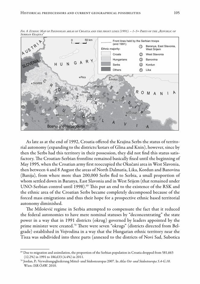
The outraged Croatian Serbs, manipulated by Serbia, after their referendum on the issue of autonomy on 30 September 1990, proclaimed the Serbian Autonomous Oblast of Krajina (SAO Krajina) with its seat in Knin, within the territory of Croatia, belong-ing in those days to Yugoslavia. Along with the escalation of the Serbo-Croatian conflict into a war, the Serbs proclaimed their independence from Croatia and joined Serbia on 2 April 1991, and later on 19 December they proclaimed the independent Republic of Serbian Krajina (RSK).66 The internationally unrecognised Serbian state formation encompassed more than a quarter (approximately 15,000 square kilometres) of the ter-ritory of Croatia including not only Krajina in a narrower sense (North Dalmatia, Lika, Kordun, Banovina/Banija having a Serbian majority population until then), but also certain western parts of Slavonia and areas along the Danube in Croatia (Baranya, West Srijem/Srem).67 (Figure 8)68
64 Weilguni, W., Suppan, A., Heuberger, V. and Koch, K.: Die Wahlen des Jahres 1990 in Mittel-, Ost- und Südosteuropa. In Atlas Ost- und Südosteuropa 6.1-G.3. Wien: ÖOSI. 1991.
65 Silber, L. and Little, A.: The death of Yugoslavia. London: Penguin Books – BBC Books. 1995.66 Dakić, M.: The Serbian Krayina. Historical Roots and Its Birth. Knin: Iskra 1994.67 Baletić, Z., Esterajher, J., Jajčinović, M., Klemenčić, M., Milardović, A., Nikić, G. and Višnar, F.: Kroatien zwischen
Aggression und Frieden. Zagreb: AGM. 1994.68 Fig. 8. Ethnic Map of Pannonian areas of Croatia and the front lines (1991). – 1–5= Parts of the „Republic of
Serbian Krajina”.
105Historical predecessors and current geographical possibilities
As late as at the end of 1992, Croatia offered the Krajina Serbs the status of territo-rial autonomy (expanding to the districts/kotars of Glina and Knin), however, since by then the Serbs had this territory in their possession, they did not find this status satis-factory. The Croatian-Serbian frontline remained basically fixed until the beginning of May 1995, when the Croatian army first reoccupied the Okučani area in West Slavonia, then between 4 and 8 August the areas of North Dalmatia, Lika, Kordun and Banovina (Banija), from where more than 200,000 Serbs fled to Serbia, a small proportion of whom settled down in Baranya, East Slavonia and in West Srijem (that remained under UNO-Serbian control until 1998).69 This put an end to the existence of the RSK and the ethnic area of the Croatian Serbs became completely decomposed because of the forced mass emigrations and thus their hope for a prospective ethnic based territorial autonomy diminished.
The Milošević regime in Serbia attempted to compensate the fact that it reduced the federal autonomies to have mere nominal statuses by “deconcentrating” the state power in a way that in 1991 districts (okrug) governed by leaders appointed by the prime minister were created.70 There were seven “okrugs” (districts directed from Bel-grade) established in Vojvodina in a way that the Hungarian ethnic territory near the Tisza was subdivided into three parts (annexed to the districts of Novi Sad, Subotica
69 Due to migration and assimilation, the proportion of the Serbian population in Croatia dropped from 581,663 (12.2%) in 1991 to 186,633 (4.4%) in 2011.
70 Jordan, P.: Verwaltungsgliederung Mittel- und Südosteuropas 2007. In Atlas Ost- und Südosteuropa 5.4-G.10. Wien: ISR ÖAW. 2010.
Fig. 8. Ethnic Map of Pannonian areas of Croatia and the front lines (1991). – 1–5= Parts of the „Republic of Serbian Krajina”
106 Károly Kocsis
and Kikinda). Incidentally, the same method was applied also with the ethnic area of the Muslims and Bosniaks in the Sanjak region. After the loss of Kosovo and the fall of Milošević, the Serbian governments gradually started to restore Vojvodina’s autonomy that had been lost after 1988. The constitution of Vojvodina that has six official lan-guages was enacted on 1 January 2010 and has been effective up to this day. Restoring the autonomy of the province that had a 2/3 Serbian majority following the 1995 mass Serbian influx also served though the interests of the Vojvodina Hungarians, who (the Democratic Fellowship of Vojvodina Hungarians, VMDK), nevertheless, had created a three-level self-governance model71 that includes the ethnic based territorial autonomy in 1992.72
The Hungarian parties forming an electoral coalition continue to have as their aim to create – along with the personal self-government – a regional self-governance for the eight Hungarian-majority municipalities (opština) near the Tisza (Hungarian Au-tonomous District).73 This prospective autonomous district, that would comprise al-most 60% of the Vojvodina Hungarians, would have 327 thousand inhabitants, out of which 53% would be Hungarians, 24.4% Serbs, 5.5% Bunjevci and Croats and 8% of unknown ethnicity (2002). The territorial autonomy has not yet been established, but a wide-scope cultural (personal) autonomy was created by the Vojvodina Hungarians mainly owing to the work of the Alliance of Vojvodina Hungarians (VMSZ).74
After the fall of communism the populous Hungarian minority communities estab-lished their independent (cultural and political) organisations not only in multi-ethnic Yugoslavia, but also on the territories of states considering themselves to be unitary nation-states, such as the present-day Ukraine, Slovakia and Romania. These organisa-tions articulated their various self-governance and autonomy concepts almost immedi-ately.75
Transcarpathia was still a part of the Soviet Union, when in 1989 the Hungarian Cultural Federation in Transcarpathia (KMKSZ) expressed its commitment to creat-
71 According to the „Memorandum on the self-government of Hungarians living in the Republic of Serbia” worded at the congress of the VMDK in Kanjiža (Magyarkanizsa) (25 April 1992): 1. Personal self-government (with the Hungarian National Council as its executive body), 2. Territorial self-governance (partnership of the Hungarian-majority municipalities/opština: Hungarian Autonomous District), 3. Local self-government (self-government for the representation of Hungarian-majority settlements outside the ethnic bloc).
72 Gerencsér, B. and Juhász, A.: A kisebbségi autonómia. Működő modellek, magyar elképzelések (The minority autonomy. Operating models, Hungarian conceptions). Budapest. 2001., Surányi, Z.: „Mindannyian akarjuk, de...” Autonómiaviták a Vajdaságban (All of us want, but... Debates on autonomy in Vojvodina). Beszélő 6. (9) 2001. http://beszelo.c3.hu/cikkek/%E2%80%9Emindannyian-akarjuk-de%E2%80%9D
73 Surányi, Z.: „Mindannyian akarjuk, de...” Autonómiaviták a Vajdaságban, op. cit., Gábrity Molnár, I.: Kisebbségi autonómia-törekvések a Vajdaságban (Autonomy aspirations of minorities in Vojvodina). In Kupa, L. (ed.): Kisebbségi autonómia-törekvések Közép-Európában – a múltban és a jelenben. Pécs: PTE – Bookmaster Kft. 2009.
74 Gábrity Molnár, I. 2009. Kisebbségi autonómia-törekvések a Vajdaságban, op. cit., Korhecz, T.: Otthonteremtőben a szülőföldön (Making home in the motherland). Novi Sad: Fórum. 2009., Korhecz, T.: Magyar autonómia Szerbiában. A programcéltól a hatályos törvényig (Hungarian autonomy in Serbia. From the political goal until the existing law). Pro Minoritate 2010. Spring, 67–73.
75 Ríz, Á.: Az 1990 után született autonómia-koncepciók összehasonlítása (Comparison of the autonomy concepts of the period 1990–2000). Korunk 2000. 3. XI. (2): 81–86.
107Historical predecessors and current geographical possibilities
ing a Hungarian autonomous district with its seat in Berehovo (Beregszász).76 At the same time, the autochthonous Slavic population of the region, the Rusyns77 (to be more precise, the Society of Carpathian Rusyns), whose independent national existence was eliminated under the Soviet supremacy, started their seemingly hopeless struggle for the restoration of the autonomy that Transcarpathia (Carpatho-Ukraine) had enjoyed in 1938–39, and this evoked extremely heated debates even locally. At the referendum held on 1 December 1991 primarily on the issue of Ukraine’s independence, the vast majority of the local population in Transcarpathia supported the special self-govern-ance status of the region (78%), and, moreover, the foundation of the Hungarian Au-tonomous District in the Rayon of Berehovo (Beregszász) (81.4%). All this, however, had no political consequence, since Kiev (pressurized by nationalist forces) sternly re-jected both endeavours.78
The unity of the young Ukrainian nation state was declared by its constitution en-acted on 28 June 1996, which was forced to acknowledge the existence of only the Au-tonomous Republic of Crimea (Krym) due to Russian pressure. Because of Ukraine’s rejection of the ethnic based territorial autonomy, starting from 2000 KMKSZ has initiated the formation of a Rayon of Tisza-region (Tisza-melléki járás) with its seat in Berehovo (Beregszász), where the Hungarians would constitute the majority of the population (72%) in a way that it would also include three quarters of the Transcar-pathian Hungarians. Only a prospective future Ukrainian administrative reform would potentially allow for the changing of the district borders that had been marked in the Soviet period and that have been unaltered in the past half a century, and even then on the condition that the ethnic perspectives are observed from a point of view that is favourable for Hungarians.
The Hungarian parties in Slovakia proposed several autonomy concepts and drafts in the 1990s; the earliest (in 1991) and most articulated claim for a territorial autono-my was expressed by the Coexistence-Együttélés Political Movement. These endeavours reached their summit and were devoted a wide scope national publicity at the Congress of Komárno (Komárom) of the Hungarian members of Slovakian parliament and of the Hungarian mayors of Slovakia (8 January 1994).79 The territorial autonomy draft pre-sented and approved depicted two scenarios (one contiguous or three Hungarian-ma-
76 Botlik, J. and Dupka, Gy.: Magyarlakta települések ezredéve Kárpátalján (Millennium of the Hungarian-populated settlements in Subcarpathia). Ungvár–Budapest: Intermix. 1993.
77 At the 2001 census only 0.8% of the Transcarpathian population (10,090 people) declared Rusyn ethnicity (in 1941 58.9%, 502 thousand Rusyn mother tongue).
78 Osztapec, J.: Politikai folyamatok Kárpátalján (1991–2009) (Political processes in Transcarpathia, 1991–2009). In Fedinec, Cs. and Vehes, M. (eds.): Kárpátalja 1919–2009 történelem, politika, kultúra. Budapest: Argumentum – MTA Etnikai-nemzeti Kisebbségkutató Intézete, 2010. 377–392.
79 Az önkormányzat az önrendelkezés alapja. A szlovákiai magyar választott képviselők és polgármesterek országos nagygyűlésének hiteles jegyzőkönyve (Self-government is the basis of the self-determination. Minutes of the general assembly of the elected Hungarian members of the Slovakian parliament and of the Hungarian mayors of Slovakia). Komárom, 8 January 1994. Komárno/Komárom: Komáromi Lapok – Szinnyei Kiadó., Gerencsér, B. and Juhász, A.: A kisebbségi autonómia. Működő modellek, magyar elképzelések, op. cit., Molnár, M.: Felvidéki magyar autonómia-törekvések, op.cit.

108 Károly Kocsis
jority regions). Had the first scenario been realised, it would have resulted in creating a region of 8,245.3 square kilometres, adjacent to the Hungarian–Slovakian borders, with approximately 824 thousand (61.5% Hungarian) inhabitants.80
The second scenario, as presented above, would have resulted in three Hungari-an-majority regions: 1. In the west between Bratislava (Pozsony) and Šahy (Ipolyság) (525 thousand people, 63.1% Hungarian), 2. In the middle, between Šahy (Ipolyság) and Košice (Kassa) (239 thousand people, 54.2% Hungarian), 3. In the east (59 thou-sand people, 77.3% Hungarian). Both the Slovak politics and wide masses of the Slovak society reacted with plain rejection, sometimes even almost hysterically to the Hungari-an plans concerning an ethnic based territorial autonomy and administrative reform.81.
Among the Slovaks (partly similarly to the Rusyns and Ukrainians), who had been fighting for their autonomy and independence under the Hungarian and the Czech supremacy for more than a century, the word “autonomy” meaning the endeavour to achieve an internal territorial self-governance, equals with the first milestone on the way to independence, an overt civic disloyalty and secessionism. Therefore, it did not come as a surprise that the Slovak Parliament in its Act 221/1996 “On Territorial and Administrative Division“ enacted such – still effective – administrative order which represents the exact opposite of the conceptions of the Hungarian parties. The new region (kraj) and district (okres) borders completely partitioned the Hungarian ethnic area in South Slovakia in a way that Hungarians were in minority in almost all medium- and higher-level administrative units so that the Hungarians’ endeavours to achieve territorial self-governance would be prevented.82
The Party of the Hungarian Coalition (MKP), that became a government party in 1998, gave up the idea of the ethnic based territorial autonomy under these new circum-stances as a result of political negotiations, although initially it strove to reconsider the law of public administration referred to above. As opposed to the Coexistence-Együt-télés draft mentioned above, they made vast allowances proposing the creation of a western region called “Podunajsko/Dunamente (or Komárno/Komárom)” with 602 thousand inhabitants comprising a 55.2% Hungarian majority between Šamorín (So-
80 Oriskó, N.: Magyarok által lakott községek és városok Szlovákiában (Communes and towns inhabited by Hungarians in Slovakia). Bratislava: Együttélés-Coexistence. 1993., Duray, M., Kvarda, J. and Oriskó, N.: A nemzetállam és demokratikus ellenszere (The nation-state and its democratic remedy). Pozsony/Bratislava: Együttélés-Spolužitie, 1994., Kocsis, K.: A közigazgatási térfelosztás változásai a mai Szlovákia területén a XX. században, op. cit.
81 Bakker, E.: Minority conflicts in Slovakia and Hungary? Capelle a/d Ijssel: Labyrint Publication. 1997., Fazekas, M.: Délvidéki és felvidéki autonómia a XX. század utolsó évtizedében. Lehetőség vagy ábránd? (Autonomy in Vojvodina and Slovakia in the last decade of the 20th century. Possibility or illusion?). In Kupa, L. (ed.): Kisebbségi autonómia-törekvések Közép-Európában – a múltban és a jelenben. Pécs: PTE–Bookmaster Kft., 2009. 163–169.
82 Kocsis, K. 2002. A közigazgatási térfelosztás változásai a mai Szlovákia területén a XX. században, op. cit., Hamberger, J.: A magyar kisebbség jogi-politikai helyzete Szlovákiában 1989 novembere után (Legal and political situation of the Hungarian minority in Slovakia following November 1989). In Bárdi, N., Fedinec, Cs. and Szarka, L. (eds): Kisebbségi magyar közösségek a 20. században. Budapest: Gondolat Kiadó – MTA Kisebbségkutató Intézet, 2008. 340–345., Szarka, L.: Útkeresés, önszerveződés a rendszerváltás éveiben (1989–1991) (Seeking ways and means, self-organisation in the period of 1989–1991). In Bárdi, N., Fedinec, Cs. and Szarka, L. (eds): Kisebbségi magyar közösségek a 20. században. Budapest: Gondolat Kiadó – MTA Kisebbségkutató Intézet, 2008. 320–329.
109Historical predecessors and current geographical possibilities
morja) and Šahy (Ipolyság). The plan of this Hungarian majority region was consid-ered “professionally unfounded” and “endangering the territorial integrity of the Slovak nation state”, thus it was sternly rejected by the Slovak government (as well as by the nationalist parties of the opposition). Since then the apparently hopeless issue of the Hungarian territorial autonomy has receded in the Hungarian parties’ politics, and the initiative was taken over by civil motions (Comorra Aula).
The largest Hungarian community beyond the borders of Hungary, with more than 1.6 million Transylvanian Hungarians at the time, founded a unified organisation for protecting their interests, called the Democratic Union of Hungarians in Romania (RMDSZ) at the end of the Romanian revolution, on 25 December 1989. By 1992 within this multi-faceted movement, a political stream articulately requesting Romania to grant minority rights, overtly demanding autonomy and relying on favourable effects of exercising pressure from abroad came into prominence, which was also reflected in requesting a fellow nation status for the Hungarians in Romania, as well as requesting autonomy and a minority law.83 This was when the first three-step autonomy models were drafted, which included the demand for a territorial autonomy (the “Region of the Hungarian National Community” based on the free partnership of the local Hungari-an-majority self-governments).84
By 1996, there were two wings within the RMDSZ, that in the meantime became a governing party: the “moderate” wing considered the process of arriving at an autono-my to be a longer one, as opposed to the “more radical” (“autonomist”) wing. By 2003, the inner conflicts between the two wings led to the foundation of the civil organisa-tion Hungarian National Council of Transylvania (EMNT), and with a similar goal, but primarily with the Székely Land in focus, the „Székely National Council (SZNT) by the prominent figures of the “more radical” wing.85 The statute of the autonomy of the Székely Land elaborated on in 2003 by the SZNT was emphatically rejected by the Romanian Chamber of Deputies and the Senate. The modified bill on the autonomy of the Székely Land was introduced in 2005, by the RMDSZ, as a member of the govern-ment, but it was rejected by the Romanian Chamber of Deputies after a few months, and by the Senate on 25 September 2012. The bill proposed the „Székely Land Auton-omous Region” to be a region encompassing 9,980 square kilometres, with a total pop-
83 Bárdi, N.: A romániai magyar kisebbség helyzetének változásai, társadalmi, kulturális önszerveződésének eredményei (Changes of the situation, results of the social, cultural self-organisation of the Hungarian minority in Romania). In Bárdi, N., Fedinec, Cs. and Szarka, L. (eds): Kisebbségi magyar közösségek a 20. században. Budapest: Gondolat Kiadó – MTA Kisebbségkutató Intézet, 2008. 330–339.
84 Csapó, I. J.: 2.2. Memorandum Tervezet A Romániai Magyar Nemzeti Közösség Belső Önrendelkezéséről, 1992 (Memorandum plan on the Internal Self-determination of the Hungarian National Community in Romania, 1992). In Csapó, I. J. (ed): Autonómiák és autonómia törekvések, 2003. 262–274., Gerencsér, B. and Juhász, A.: A kisebbségi autonómia. Működő modellek, magyar elképzelések, op. cit., Bognár, Z. (ed.): Romániai autonómia-elképzelések 1989 után (Autonomy conceptions in Romania following 1989). www.adatbank.ro/belso.php?alk=48&k=5
85 The MNT, fighting for the territorial autonomy overtly and striving to reach results quickly was founded on 25 April 2003 in Odorheiu Secuiesc (Székelyudvarhely), while the SZNT was founded on 16 October 2003 in Sfântu Gheorghe (Sepsiszentgyörgy). Former members of the RMDSZ founded the Hungarian Civic Party in 2008 and the Hungarian People’s Party of Transylvania in 2011.

110 Károly Kocsis
ulation of 809 thousand of which 76% Hungarians. The planned autonomous region would primarily have included the today’s counties of Harghita (Hargita) and Covasna (Kovászna) and the south-eastern part of Mureş (Maros) county.
It is a little-known fact in connection with the autonomy struggles of the Transylva-nian Hungarians that the EMNT supported the elaboration of a plan of a Hungarian autonomous region in Northwest Romania (Partium region).86 There have been several plans prepared for the region inhabited by a Hungarian–Romanian mixed population adjacent to the Hungarian border that has been considered by Romanians as a potential irredentist danger. The plan encompassing the largest territory would accommodate 349 thousand people (191 thousand, 54.5% Hungarian and 130 thousand, 37.1% Ro-manian) and would also include the city Satu Mare (Szatmárnémeti) and towns Carei (Nagykároly), Şimleu Silvaniei (Szilágysomlyó) and Marghita (Margitta). This plan has not become known by the Romanian public. For the time being, the Hungarians in Northwest Romania are getting accustomed to the idea that they might achieve a terri-torial autonomy on their homeland.
As a consequence of the series of failures regarding plans on territorial autonomy, the RMDSZ proposed the creation of a region uniting the counties Mureş (Maros), Harghita (Hargita) and Covasna (Kovászna) by restructuring the development regions planned in 1998 before the 2007 EU elections.87 This proposal for restructuring the administration of Romania was kept up until the negotiations with the president’s com-mittee of professional experts in 2010 (15 regions, one of them with a Hungarian ma-jority).
Based on the failures of the autonomy struggles of the Hungarian minorities in Ro-mania, Slovakia and Ukraine, it can be argued that both the titular nations and the Hun-garian parties should change their approach. The Romanian, Slovakian and Ukrainian decision-makers should see the reasons and understand that a territorial autonomy is not an attack on sovereignty and does not necessarily lead to a separation, but, on the contrary, if it operates successfully, it can be a form of integration and an effective means of overcoming conflicts. Simultaneously Hungarian minority politicians, who are at the moment seriously divided, should realise that autonomy is not a magic potion and it cannot be reached by unilateral declarations, but there should be (among others) a unity of action towards the titular nations, and at the same time, an atmosphere of trust has to be created, and all this takes a long time, patience and political wisdom.88
86 Szilágyi, F. and Csomortányi, I.: Önrendelkezés a Partiumban (Autonomy in North-west Romania). Oradea (Nagyvárad): Partium Kiadó. 2010.
87 Csutak, I.: Új? Régi? Jó? (New? Old? Good Regions?) Csíkszereda: Alutus. 2007., Szilágyi, F.: Az új román területi közigazgatás lehetséges elvi alapjai (Possible fundamental principles of the new Romanian territorial-administrative division). Magyar Kisebbség 2010. New Sery XV. (3–4) (57–58): 225–246.
88 Salat, L.: Autonómiák évadja Erdélyben (Season of the autonomies in Transylvania). Krónika VI. 6. Jan. 10–11, 2004.

111Historical predecessors and current geographical possibilities
The current geographical possibilities of ethnic based territorial autonomies in the Carpathian Basin
Beyond the necessary political conditions, historical traditions and lucky circumstanc-es,89 some ethnic and geographical-demographical conditions, as proposed above, need to be met (the minority should outnumber the titular state majority; the settlement area should be relatively contiguous and large enough as well as economically sustainable) in order to reach ethnic based territorial autonomies (or at least regional associations of local self-governments with the minority in majority). These latter conditions are only met in the ethnic territories of the Hungarians in Slovakia, Transcarpathia, Transylvania and Vojvodina mentioned in the previous chapter (Figure 9).90 Although a century ago there used to be several hundred thousand German and Serbian minority inhabitants in the Carpathian Basin, due to the forced emigrations (for the Germans 1944–50 and the Serbs 1991–95), the territorial autonomy is no longer accomplishable for them.
89 See Ghai, Y. (ed.): Autonomy and Ethnicity: Negotiating Competing Claims in Multi-Ethnic States. Cambridge: Cambridge University Press. 2002.
90 Fig. 9. Geographically possible ethnic based territorial autonomies in the Carpatho-Pannonian area. – 1 = Bosniaks, Muslims by ethnicity; 2 = Croats, Bunjevci, Šokci; 3 = Czechs; 4 = Germans, German speaking Austrians; 5 = Hungarians; 6 = Poles; 7 = Romanians; 8 = Romani people; 9 = Serbs; 10 = Slovaks; 11 = Slovenes; 12 = Ukrainians; 13 = Other ethnic groups
Fig. 9. Geographically possible ethnic based territorial autonomies in the Carpatho-Pannonian area. – 1 = Bosniaks, Muslims by ethnicity; 2 = Croats, Bunjevci, Šokci; 3 = Czechs; 4 = Germans, German speaking Austrians; 5 = Hungarians; 6 = Poles; 7 = Romanians; 8 = Romani people; 9 = Serbs; 10 = Slovaks; 11 = Slovenes; 12 = Ukrainians; 13 = Other ethnic groups

112 Károly Kocsis
During the last century on today’s territory of Slovakia, the number and the pro-portion of people declaring Hungarian ethnicity (or mother tongue) has continuously decreased due to the forced migrations, assimilation processes and the anti-Hungarian climate of opinion connected to the building of the Czechoslovak (then, from 1993 the Slovak) nation state.91 In spite of this, the vast majority of the Hungarians still consti-tute a more or less contiguous settlement area in the southern regions of the country, near the Hungarian border, where there was a native Hungarian-speaking majority in 414 towns and villages in 2011. Since the conspicuously anti-Hungarian administra-tive reforms (1960, 1996), only two (Komárno and Dunajská Streda) of the present 79 districts of Slovakia retained their Hungarian majority. Should natural hinterlands (catchment areas), historical traditions and ethnic relations be considered, there could be 16 districts created in Slovakia with a Hungarian-speaking majority population.92 (Figure 10).93
All the seats of these possible districts used to be district or county seats in the past century.94 Out of the districts lining up near the Slovakian–
91 Hungarians on the present-day territory of Slovakia (m: mother tongue; e: ethnicity): in 1910 880,851 (m), in 1930 585,434 (e), in 1991 567,296 (e), in 2011 458,467 (e).
92 Michniak, D.: Zázemia vybraných centier dochádzky do zamestnania v roku 2001 (Hinterlands of selected commuting centres, 2001). In Atlas obyvateľstva Slovenska. Bratislava: Univerzita Komenského. 2006., Halás, M. and Klapka, P.: Contribution to regional division of Slovakia based on the application of Reilly’s model. Hungarian Geographical Bulletin 2012. 61. (3): 237–255.
93 Fig. 10. Ratio of the Hungarians on the territory of the geographically possible Autonomous Region of South Slovakia (1941, 2011)
94 Kocsis, K.: A közigazgatási térfelosztás változásai a mai Szlovákia területén a XX. században, op. cit.
Fig. 10. Ratio of the Hungarians on the territory of the geographically possible Autonomous Region of South Slovakia (1941, 2011)

113Historical predecessors and current geographical possibilities
Hungarian border, 9 in the west, 5 in the middle and 2 in the east could constitute an association (“Autonomous Region of South Slovakia”), the total population of which would exceed 680 thousand; according to the mother tongue 63.5% (432 thousand) would be Hungarian, 27.9% (190 thousand) Slovak, and 1.6% (11 thousand) Roma (Table 1). Table 1. Ethnic structure of the population on the territory of the possible „Autonomous Region of South Slovakia” (1941–2011)
Year
Total popula-tion
Hungar-ians Slovaks Roma Others
Hungar-ians Slovaks Roma Others
Population number Ratio in per cent 194120012011
571,198681,148680,493
545,481473,912432,445
18,854184,556189,719
3,43310,14211,196
3,43012,53847,133
95.569.663.5
3.327.127.9
0.61.51.6
0.61.87.0
Sources: Mother tongue data of the Hungarian (1941) and Slovakian (2001, 2011) popula-tion censuses.
Only 15% of the Hungarians would remain outside this imaginary region, the ma-jority of whom live in Bratislava and in the towns of the Slovakian–Hungarian lin-guistic boundary that used to have a Hungarian majority until 1945, and since then predominantly a Slovakian majority (Senec, Šaľa, Levice, Lučenec, Košice).
In spite of the emigrations in the past half century, the number of Hungarians in Transcarpathia (Ukraine) has not decreased dramatically (1959: 146 thousand, 1979: 158 thousand, 2001: 152 thousand). Out of the 13 rayons of the region there is a Hun-garian majority in the rayon of Berehovo (Beregszász) only, constituted by (including the town of Berehovo/Beregszász) a mere 35.6% of the Transcarpathian Hungarians. It would be necessary to reconsider the district borders that had been unchanged for the past 60 years in a way that natural hinterlands and ethnic scenes are considered; thus in the ethnic territory of the Hungarian minority adjacent to the Hungarian–Ukrainian border it would be reasonable to detach a rayon of Čop (Csap) with 49 thousand inhab-itants from the actual district of Uzhhorod (Ungvár), and a rayon of Vylok (Tiszaújlak) with 38 thousand inhabitants from today’s rayon of Vynohradiv (Nagyszőlős) (Figure 11)95.96 The three new districts formed this way would have an absolute Hungarian majority and they could join to create an association (“Autonomous District of Tisza Region”, Prytysianska), the total population of which would exceed 165 thousand, with
95 Fig. 11. Ratio of the Hungarians on the territory of the geographically possible Autonomous District of Tisza Region (Prytysianska) in Ukraine (1941, 2001).
96 The number of inhabitants in these imagined rayons would exceed the population number of today’s rayons of Velykyy Bereznyi, Perechyn and Volovets. The new rayons created this way along the Hungarian–Ukrainian border would be: rayon of Čop (Csap) (48,907 inhabitants, 63.7% Hungarian, 27.1% Ukrainian); rayon of Berehovo (Beregszász) (79,553 inhabitants, 69.4% Hungarian, 23.3% Ukrainian); rayon of Vylok (Tiszaújlak) (37,531 inhabitants, 71.4% Hungarian, 28.1% Ukrainian).
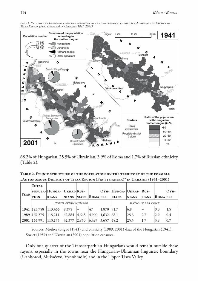
114 Károly Kocsis
68.2% of Hungarian, 25.5% of Ukrainian, 3.9% of Roma and 1.7% of Russian ethnicity (Table 2).
Table 2. Ethnic structure of the population on the territory of the possible „Autonomous District of Tisza Region (Prytysianska)” in Ukraine (1941–2001)
Year
Total popula-tion
Hunga-rians
Ukrai- nians
Rus-sians Roma
Oth-ers
Hunga-rians
Ukrai-nians
Rus-sians Roma
Oth-ers
Population number Ratio in per cent 194119892001
123,758169,275165,991
113,466115,211113,175
8,37542,88442,377
–4,6482,850
474,9006,497
1,8701,6323,657
91.768.168.2
6.825.325.5
–2.71.7
0.02.93.9
1.50.40.7
Sources: Mother tongue (1941) and ethnicity (1989, 2001) data of the Hungarian (1941), Soviet (1989) and Ukrainian (2001) population censuses.
Only one quarter of the Transcarpathian Hungarians would remain outside these rayons, especially in the towns near the Hungarian–Ukrainian linguistic boundary (Uzhhorod, Mukačevo, Vynohradiv) and in the Upper Tisza Valley.
Fig. 11. Ratio of the Hungarians on the territory of the geographically possible Autonomous District of Tisza Region (Prytysianska) in Ukraine (1941, 2001)

115Historical predecessors and current geographical possibilities
Almost all the Hungarians of Romania lived on the territories belonging to Hungary until 1918, in Transylvania in the broader sense, where their number rapidly decreased in the past almost four decades – primarily because of the accelerated rate of emigra-tion (1977: 1.7 million, 2002: 1.4 million and 2011: 1.2 million ethnic Hungarians). Presently approximately half of the Transylvanian Hungarians live in the Székely Land, almost one fifth live in Northwest Romania (Partium or Crişana-Maramureş), while one third struggles for ethnic survival in enclaves, diasporas. Since the administrative reform of 1968, out of the 16 counties of Transylvania only two, Harghita and Covas-na, had a Hungarian majority.
In 2011 out of the present 1,192 Transylvanian cities, towns and communes 214 had a Hungarian majority. From among the territories populated by minorities in the Carpathi-an Basin a possibility of an ethnic based territorial self-governance seems to be the most ob-vious in the Transylvanian Székely Land if we consider the ethnic, economic and historical background. The Hungarian (Székely) population living there enjoyed territorial autono-my from the 14th century until 1876 (and from 1952 to 1960/68). The dominantly Hun-garian ethnic nature of the historic-ethnic region called Székely Land has remained intact from the 13th century up to recently. Without changing the boundaries of the municipal-ities, communes, reconsidering the catchment areas, the ethnic structure and the historical background, it would be possible to join the Hungarian-majority towns and communes of the counties of Harghita, Covasna and Mureş to create a self-governance region (“Autono-mous Region of Székely Land”), which would be home to 750 thousand (76.5% Hungari-an-speaking and 21.5% Romanian-speaking) inhabitants (Figure 1297, Table 3).
Table 3. Ethnic structure of the population on the territory of the possible „Autonomous Region of Székely Land” in Romania (1941–2011)
Year
Total popula-tion
Hunga-rians
Romani-ans Roma Others
Hunga-rians
Romani-ans Roma Others
Population number Ratio in per cent 194120022011
615,945806,153750,117
558,911618,753573,724
43,592173,865161,357
812,36712,571
13,4341,1682,465
0.776.876.5
7.121.621.5
0.01.51.7
2.20.10.3
Sources: Mother tongue data of the Hungarian (1941) and Romanian (2002, 2011) popula-tion censuses.
As opposed to the historical Székely seats (Székely Land) existing until 1876, this territory would not include the Romanian-majority areas of Buzău and Becaş, Topliţa and its environs, while the adjacent Hungarian-majority communes (outside the histor-ical Székely Land) could be incorporated.
97 Fig. 12. Ratio of the Hungarians on the territory of the geographically possible Autonomous Region of Székely Land (1941, 2011)

116 Károly Kocsis
In the north-western part of Romania, in the so called Partium (Crişana-Mara-mureş) region, on the territories of the counties of Bihor, Satu Mare and Sălaj, an asso-ciation of 86 (mostly Hungarian majority) towns and communes (“Autonomous Dis-trict of Partium”) would be conceivable based on the catchment area of towns and the prevailing ethnic pattern, where 430 thousand (56% Hungarian-speaking, 41.1% Ro-manian-speaking and 1.9% Roma-speaking) inhabitants could enjoy a territory based self-governance (Figure 1398, Table 4).
This region would approximately coincide with the joint territory of the elector-al districts of Chamber of Deputies in which a Hungarian party (RMDSZ) won the majority of the votes on 9 December 2012. One third of the Transylvanian Hungar-ians would remain outside the above mentioned territories, mainly in cities (e.g. in Cluj-Napoca/Kolozsvár 49 thousand, Oradea/Nagyvárad 46 thousand, Braşov/Brassó 16 thousand, Timişoara/Temesvár 15 thousand, Baia Mare/Nagybánya 14 thousand) and in the Transylvanian basin, where an autonomy based on a local and personal prin-ciple could help preserve their ethnic identity.
98 Fig. 13. Ratio of the Hungarians on the territory of the geographically possible Autonomous District of Northwest Romania (Partium) (1941, 2011)
Fig. 12. Ratio of the Hungarians on the territory of the geographically possible Autonomous Region of Székely Land (1941, 2011)

117Historical predecessors and current geographical possibilities
Table 4. Ethnic structure of the population on the territory of the possible „Autonomous District of Northwest Romania (Partium)”(1941–2011)
Year
Total popula-tion
Hunga-rians
Romani-ans Roma Others
Hunga-rians
Romani-ans Roma Others
Population number Ratio in per cent 194120022011
430,790470,046429,528
324,945257,758240,671
92,839196,508176,336
2,2758,6568,012
10,7317,1244,509
75.454.956.0
21.641.841.1
0.51.81.9
2.51.51.0
Sources: Mother tongue data of the Hungarian (1941) and Romanian (2002, 2011) popula-tion censuses.
Almost all the Hungarians of Serbia (251 thousand people) live on the territory of the Vojvodina Autonomous Province, where they are in majority in eight munici-
palities. These administrative units, located near the Hungarian–Serbian border and the Tisa, in the hinterland of the cities of Subotica/Szabadka and Senta/Zenta, could voluntarily join to form an “Autonomous District of North Bačka” with 301 inhabit-
Fig. 13. Ratio of the Hungarians on the territory of the geographically possible Autonomous District of Northwest Romania (Partium) (1941, 2011)

118 Károly Kocsis
ants, 50.4% of whom would be Hungarians, 25.8% Serbs and 9.5% Bunjevci and Croats (Figure 1499, Table 5).
Table 5. Ethnic structure of the population on the territory of the possible „Autonomous District of North Bačka (Potisje)” in Serbia (1941–2011)
Year
Total popula-tion
Hungari-ans Serbs
Bunjevci, Croats Others
Hungar-ians Serbs
Bunjevci, Croats Others
Population number Ratio in per cent 194120022011
327,028327,031301,305
241,998173,279151,999
32,90879,77477,679
37,65834,54028,678
14,46470,52442,949
74.053.050.4
10.124.425.8
11.510.6
9.5
4.412.014.3
Sources: Mother tongue (1941) and ethnicity (2002, 2011) data of the Hungarian (1941) and Serbian (2002, 2011) population censuses.
99 Fig. 14. Ratio of the Hungarians on the territory of the geographically possible Autonomous District of North Bačka (Potisje) (1941, 2011)
Fig. 14. Ratio of the Hungarians on the territory of the geographically possible Autonomous District of North Bačka (Potisje) (1941, 2011)
119Historical predecessors and current geographical possibilities
Although 40% of the Vojvodina Hungarians (100 thousand people) would remain outside this territory, their already existing cultural autonomy (based on a personal principle) and their national minority self-government organisation, the National Council of the Vojvodina Hungarians would continue to support the preservation of their national identity.
Conclusion
The territorial autonomies as the most effective tools of minority protection and the most modern forms of internal self-governance of minorities that have been created in the past decades one after the other, all over the world, do not count as novelties on the historical territory of Hungary, in the Carpathian Basin. The Hungarian rulers granted such ter-ritorial self-governance in exchange for military service to different ethnic groups (e.g. Saxons, Székelys, Romanians, Cumans, Jassic people and Serbs) from the 13th century, the majority of which remained in existence until the second half of the 19th century.
By the end of the 18th century, the birth of the modern nations and nationalism and by Joseph II’s Germanizing enlightened absolutism, the proportion of ethnic minorities reached 2/3 of the country’s population (while until the end of the 15th century only one third of inhabitants were non-Hungarians) due to reasons related to demographic processes and wars that were basically reshaping the ethnic structure of the country from the end of the Middle Ages. Due to the increasing growth of their demograph-ic weight, their political consciousness and their nationalism brought partly about by the Hungarian nationalism (but also further provoked by the Habsburg Empire), the national minorities started to claim the recognition and implementation of their ex-istence as independent political nations and their ethnic based territorial autonomies more and more articulated from the middle of the 19th century.
The Hungarian state, following the Austro–Hungarian Compromise (1867), was granted internal self-governance within the Austro–Hungarian Monarchy, howev-er, Hungary denied the same right from the national minorities (except for the Cro-ats) living on its territory. The reason for this denial was the same as in the case of all other countries aiming to build an ethnically-politically unitary nation state: a fear of attempts of the minorities to separate, a fear that the territorial integrity of the state should be infringed and that the state borders that were hope to remain ever-lasting should be changed. It is regrettable that the Hungarian state that used to excel at eth-nic-linguistic tolerance from the times of St. Stephen until the 19th century, submitting to the spirit of the age and complying with the illusion of the French nation-state idea, made a mistake by denying (among others) the ethnic-territorial autonomy requests of the minorities, that resulted in the estrangement of the minorities followed by their separation after the first world war, and, as a final outcome, in the dissolution of the thousand-year-old Hungarian state.

120 Károly Kocsis
At the end of 1918, on the territory of the multi-ethnic Habsburg Empire new mul-ti-ethnic, middle-sized “nation-states” were created, the borders of which had been drawn in a way that was disadvantageous for Hungary and thus several millions of Hungarians mainly in the border regions fell under their supremacy. In order to protect their territorial integrity the neighbours of Hungary did not only deny the autonomy requests of the Hungarian minorities treated as third-rate minorities, but also those of their “fellow-nations” (e.g. Slovaks, Rusyns, Croats) considered as second-rate minor-ities.
In the period between 1938 and 1944, the Third Reich (in order to reach its con-quering aims) made use of the desperation of the nations and minorities in the Car-pathian Basin that were suppressed between the two world wars and it successfully applied the ancient Roman principle of “divide et impera”. It repelled the countries of the formerly ruling nations (Czechs, Romanians, Serbs) to their ethnic core areas with the new boundaries, “donated independence” to the Slovaks and Croats and allowed the Hungarians to unite their ethnic territory, that is approved of the re-annexation of the territories populated by Hungarians that were lost in 1919.
In the countries of the Carpathian Basin (except for Austria) that came under the influence (mainly military occupation) of the Soviet Union after the second world war, Soviet-type communist regimes were built, which made it impossible for the follow-ing decades (in a general anti-minority atmosphere) to establish an actual territorial self-governance. The forced migrations between 1944 and 1950 already pointed in this direction, which basically transformed the ethnic structure of the region by removing the Germans almost entirely, weakening the Hungarian minorities and colonising main-ly Slovaks, Ukrainians, Russians, Romanians and Serbs in great masses. In the decades of socialism only Vojvodina in Serbia (1945–1989) and the Hungarian Autonomous Region in Romania (under Soviet pressure, between 1952 and 1960–68) can be men-tioned as examples of permanent and temporary territorial autonomies, respectively.
During the years of the Yugoslav wars, there was a short period of territorial autono-my and independence in the case of the Serbian Krajina, which sank irrecoverably into history in 1995. After the years of the political transition, the significant Hungarian minorities of the Carpathian Basin have elaborated on their autonomy concepts that typically consist of three steps. Within these frameworks they directly articulated and frequently submitted as bills their notion of territorial self-governance, which was im-mediately (and in certain cases repeatedly) rejected by the Slovakian, Ukrainian, Ro-manian and Serbian parties.
Because of the shocking effects of the socioeconomic systemic change (1990– ) and the world economic crisis (2008– ), the lack of welfare, the increasing social polarisa-tion, the disappearance of the former strong central power, the lack of a democratic civil society, the existence of populous ethnic and national minorities and some bitter historical memories, the politics frequently turns to nationalism as a weapon in the countries of the Carpathian Basin. Nationalist powers frequently provoke minorities, especially if they are large in number and live on a relatively continuous ethnic territo-ry in order to prove that minorities mean a (mostly irredentist) danger. As a result of
121Historical predecessors and current geographical possibilities
the economic and political difficulties, the governments in question make attempts at centralising the state functions rather than at devolution the power and they, especial-ly, oppose establishing ethnic based territorial autonomies, which the titular nations conceive to be overt attacks on the territorial integrity of the state. In this respect the lessons learnt from unsuccessful examples (e.g. Kosovo, Abkhasia, Karabah) are empha-sised over successful, positive European ones.
The geographical and demographical conditions of an ethnic based territorial self-governance are available in the case of most of the settlements of Hungarian na-tional communities in Slovakia, Transcarpathia, Transylvania (Székely Land and Par-tium) and Vojvodina (North Bačka). It seems, however, that for the time being, due to the reasons outlined above, both short-term and medium-term political conditions are missing, even in the case of attempting to realise ethnic based associations of local self-governments (municipalities) of minorities.