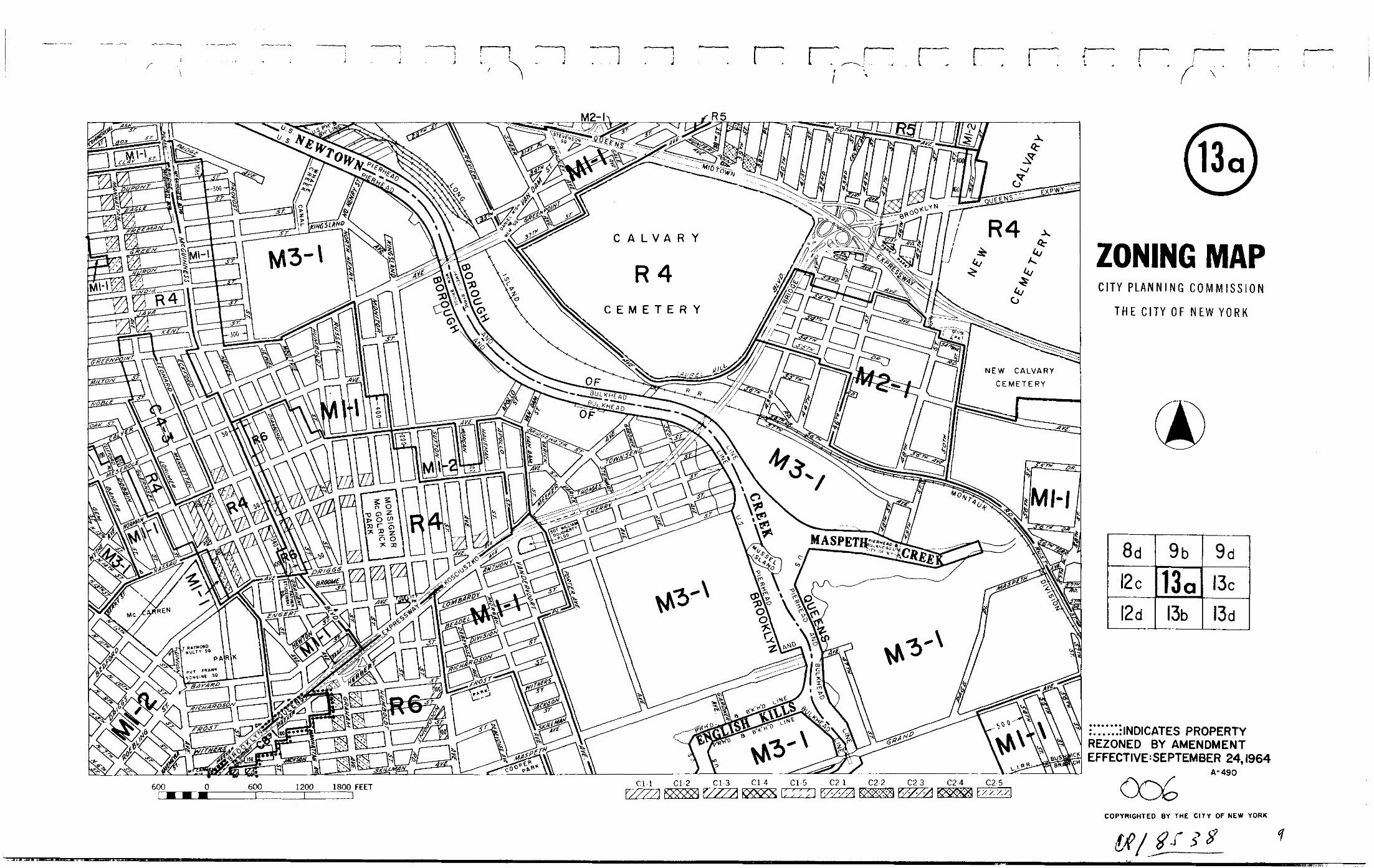
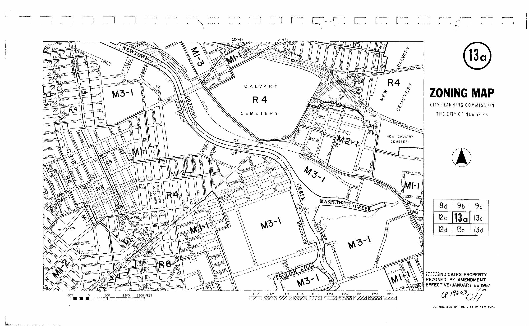
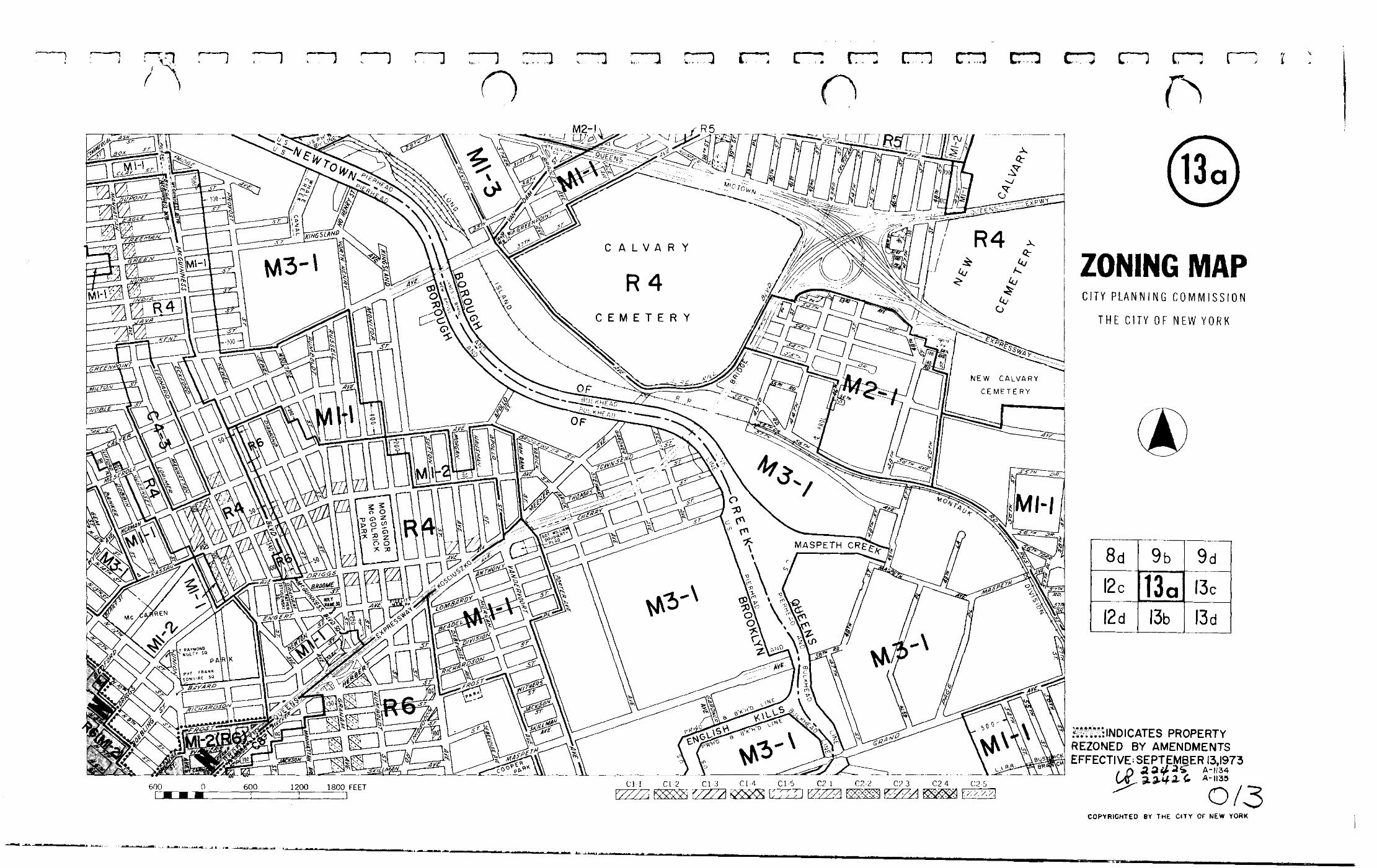
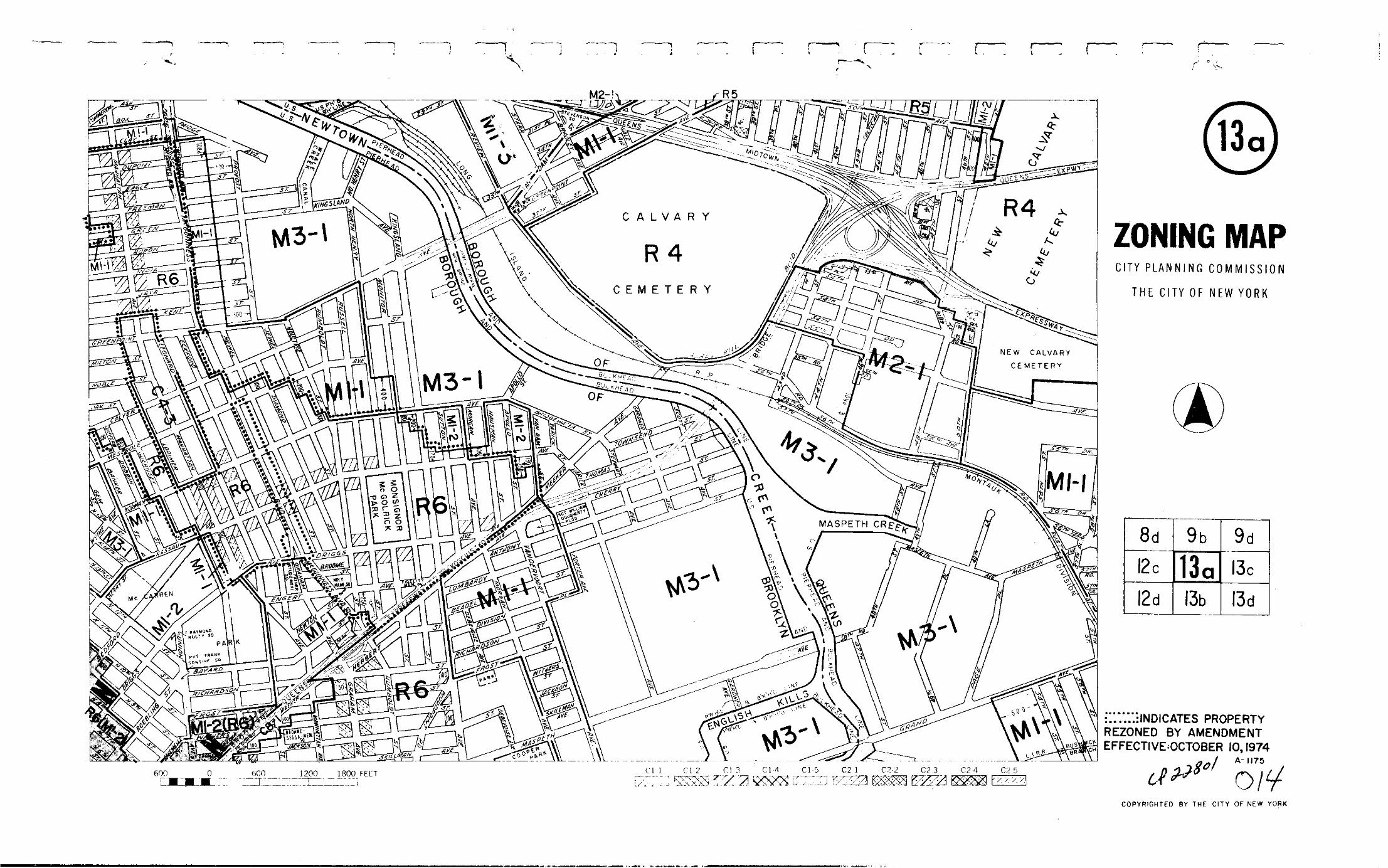
Historical Map - 13a 100 100 70 e ve. an ve. h e. gs ave. d henry rd st. r6a r6-ts ave. ns yn ko dge...
32
Transcript of Historical Map - 13a 100 100 70 e ve. an ve. h e. gs ave. d henry rd st. r6a r6-ts ave. ns yn ko dge...


ST.
ST.
BOX
AVE.
AVE.
HAVEMEYER
FROST
RICHARDSONST. CONO STRADA
RICHARDSON
ENGERT
NEWTON
WITHERS ST.WITHERS
150
150
MT. CARMEL
ST.
UNION
ST.
607
M1-2/R6M1-2/R6A300
M1-2R6M
1-2/
R6A
M1-
2
M1-2/
M1-
2/R
6AR6A
R6BM1-2/
ST.
ST.
M1-2/
M1-2/R6A R6B
ST.
M1-2/R6A ST.
NASSAUST.
100
100100
100100
100
100
100
100
MX
-8
MX-8
MX-8
100
100
M1-2/
150
250
100
100
ST.
C
MEEKER
L
CL
ASH
COMMERCIAL
ST.
PROL.
N. 11 TH
R6A
M1-2/R6
ST.
HERBERT
BAYARDST.
SQ.
R6B
13a
8d 9b 9d
13c
13d13b12d
12c
13aZ
ON
ING
MA
P
MAP KEY
Copyrighted by the City of New Yorkc
ZONING MAPTHE NEW YORK CITY PLANNING COMMISSION
D
E
R, C M
NOTE: Zoning information as shown on this map is subject tochange. For the most up-to-date zoning information for this mapcheck the Department of City Planning website:http://www.nyc.gov/html/dcp/html/subcats/zoning.htmlor contact the Zoning Information Desk at (212) 720-3291.NOTE: Where no dimensions for zoning district boundaries appear on the zoning maps, such dimensions are determined
in Article VII, Chapter 6 (Location of District Boundaries) of the Zoning Resolution.
600 0 600 1200 1800 FEET C1-1 C1-2 C1-3 C1-4 C1-5 C2-1 C2-2 C2-3 C2-4 C2-5
ST.
ROEBLING
N. 7 TH
ST.
ST.
N. 8 TH
ST.
ST.
N. 12 TH
BERRYAVE.
N. 15 TH
ST. ST.
AVE.
ST.
CLAY
e2
e2
e2
e2
e2
e2
e2
e2
e2
e2e2
e2
e2
e2
e2
e2
e2
e2
e2
e2
e2e2
e2
e2
e2e2
e2e2
e2
e2
e2
e2
e2
e2
e2
e2 e2
e2e2
e2
e2
e2
e2
e2
e2
e2
e2
e2
e2
e2
e2
e2
R6B
R7A
FATHER
STUDZINSKI
SQ.
R6
e2
e2
e2
86
M1-2/R6
e2
100
JACKSON ST.
OUR LADYOF THESNOWS SQ.
PARK
100
M1-2/R6
M1-2/R6

13a
8d 9b 9d
13c
13d13b12d
12c
13aZ
ON
ING
MA
P
MAP KEY
Copyrighted by the City of New Yorkc
ZONING MAPTHE NEW YORK CITY PLANNING COMMISSION
D
E
R, C M
ST.
ST.
BOX
AVE.
AVE.
HAVEMEYE
R
FROST
RICHARDSONST. CONO STRADA
RICHARDSON
ENGERT
NEWTON
WITHERS ST.WITHERS
150
MT. CARMEL
ST.
UNION
ST.607
M1-2/R6M1-2/R6A300
M1-2R6
M1-
2/M
1-2
M1-2/
M1-
2/R
6AR6A
R6BM1-2/
ST.
ST.
M1-2/
M1-2/R
6A R6B
ST.
M1-2/R6A
ST.
NASSAUST.
100
100100
100100
100
100
100
100
MX
-8
MX-8
MX-8
100
100
M1-2/250
100
100
ST.
C
MEEKER
L
CLASH
COMMERCIAL
ST.
PROL.
N. 11 TH
R6A
M1-2/R6
ST.
HERBERT
BAYARDST.
SQ.
R6B
ST.
ROEBLING
N. 7 TH
ST.
ST.
N. 8 TH
ST.
ST.
N. 12 TH
BERRY
AVE.
N. 15 TH
ST.
ST.
AVE.
ST.
CLAY
e2
R6B
R7A
86
M1-2/
100
JACKSON ST.
OUR LADYOF THESNOWS SQ.
PARK
100
M1-2/R6 NOTE: Zoning information as shown on this map is subject tochange. For the most up-to-date zoning information for this map,visit the Zoning section of the Department of City Planning website:www.nyc.gov/planning or contact the Zoning Information Desk at(212) 720-3291.NOTE: Where no dimensions for zoning district boundaries appear on the zoning maps, such dimensions are determined
in Article VII, Chapter 6 (Location of District Boundaries) of the Zoning Resolution.
600 0 600 1200 1800 FEET C1-1 C1-2 C1-3 C1-4 C1-5 C2-1 C2-2 C2-3 C2-4 C2-5
ST.
ST.
ST.
ST.
AVE.
GREENPOINT
ST.-GREENGEORGE APEN
ST.
AVE.
DRIGGS
AVE.
ST.
FIDELITY
ST.
AVE.
PULASKILEONARD
ST.
100
100
100
100
100
100
60
50
85
120
50
CL
KINGSLAND
OLIVE ST.
LORIMER
STUDZINSKIFATHER
SQ.
EXPWY
75
CL
100 100
BLVD.
100
100 100
150
100
CL
CLCL
CL
CL
100100
100
100
100
CL
100
75100
75
75100
75100
100
100100
100
100100
100
R6
R6B
R6A
R7A
R6A
R6B
R6B
C4-3A
R6B
R6B
R7A
R6
R6BR6A
R6A
R6B
R6B
100
250
CLCL
150
125
80
70
McGUINNESS
BRIDGE
100
75
100
100
CL
E-232
E-232
E-232
E-232
E-232
R6A
E-232
E-232
MILTON
CL
M1-2/R6
ST.
ST.
ST.
100
ST.
KENT
JAVA
INDIA
HURON
GREEN ST.
GREENFREEMAN
EAGLE
DUPONT
PAIDGE
AVE.MANHATTAN
AVE.MANHATTAN
100
100
170
DEBEVOISE
AVE.
MORGAN
AVE.
MASPETH
AVE.
DRIGGS
AVE.
KINGSLANDNORTH
HENRY
ST.BEDFORD
R6A
R6
AVE. -GRANDPARENTS
AVE.
QUEENS
BROOKLYN
KOSCIUSZKO
BRID
GE
RUSSELL
VAN DAM
BANKER
ST.
R6B
R6A
WYTHE
WALESA-SOLIDARITY
SQUARE
MEM. PK.
AVE.GUERNSEY
NO. HENERY
ST.
R6B
R6B
AVE.
N. 10 TH
THOMAS ST.
THOMASST.

13a
8d 9b 9d
13c
13d13b12d
12c
13aZ
ON
ING
MA
P
MAP KEY
Copyrighted by the City of New Yorkc
ZONING MAPTHE NEW YORK CITY PLANNING COMMISSION
D
E
R, C M
ST.
ST.
BOX
AVE.
AVE.
HAVEMEYE
R
FROST
RICHARDSONST. CONO STRADA
RICHARDSON
ENGERT
NEWTON
WITHERS ST.WITHERS
150
MT. CARMEL
ST.
UNION
ST.607
M1-2/R6M1-2/R6A300
M1-2R6
M1-
2/M
1-2
M1-2/
M1-
2/R
6AR6A
R6B
M1-2/ST.
ST.
M1-2/
M1-2/R
6A R6B
ST.
M1-2/R6A
ST.
NASSAUST.
100
100100
100100
100
100
100
100
MX
-8
MX-8
MX-8
100
100
M1-2/250
100
100
ST.
C
MEEKER
L
CLASH
COMMERCIAL
ST.
PROL.
N. 11 TH
R6A
M1-2/R6
ST.
HERBERT
BAYARDST.
SQ.
R6B
ST.
ROEBLING
N. 7 TH
ST.
ST.
N. 8 TH
ST.
ST.
N. 12 TH
BERRY
AVE.
N. 15 TH
ST.
ST.
AVE.
ST.
CLAY
e2
R6B
R7A
86
M1-2/
100
JACKSON ST.
OUR LADYOF THESNOWS SQ.
PARK
100
NOTE: Zoning information as shown on this map is subject tochange. For the most up-to-date zoning information for this map,visit the Zoning section of the Department of City Planning website:www.nyc.gov/planning or contact the Zoning Information Desk at(212) 720-3291.NOTE: Where no dimensions for zoning district boundaries appear on the zoning maps, such dimensions are determined
in Article VII, Chapter 6 (Location of District Boundaries) of the Zoning Resolution.
600 0 600 1200 1800 FEET C1-1 C1-2 C1-3 C1-4 C1-5 C2-1 C2-2 C2-3 C2-4 C2-5
ST.
ST.
ST.
ST.
AVE.
GREENPOINT
ST.-GREENGEORGE APEN
ST.
AVE.
DRIGGS
AVE.
ST.
FIDELITY
ST.
AVE.
PULASKILEONARD
ST.
100
100
100
100
100
100
60
50
85
120
50
CL
KINGSLAND
OLIVE ST.
LORIMER
STUDZINSKIFATHER
SQ.
EXPWY
75
CL
100 100
BLVD.
100
100 100
150
100
CL
CLCL
CL
CL
100100
100
100
100
CL
100
75100
75
75100
75100
100
100100
100
100100
100
R6
R6B
R6A
R7A
R6A
R6B
R6B
C4-3A
R6B
R6B
R7A
R6
R6BR6A
R6A
R6B
R6B
100
250
CLCL
150
125
80
70
McGUINNESS
BRIDGE
100
75
100
100
CL
E-232
E-232
E-232
E-232
E-232
R6A
E-232
E-232
MILTON
CL
M1-2/R6
ST.
ST.
ST.
100
ST.
KENT
JAVA
INDIA
HURON
GREEN ST.
GREENFREEMAN
EAGLE
DUPONT
PAIDGE
AVE.MANHATTAN
AVE.MANHATTAN
100
100
170
DEBEVOISE
AVE.
MORGAN
AVE.
MASPETH
AVE.
DRIGGS
AVE.
KINGSLANDNORTH
HENRY
ST.BEDFORD
R6A
R6
AVE. -GRANDPARENTS
AVE.
QUEENS
BROOKLYN
KOSCIUSZKO
BRID
GE
RUSSELL
VAN DAM
BANKER
ST.
R6B
R6A
WYTHE
WALESA-SOLIDARITY
SQUARE
MEM. PK.
AVE.GUERNSEY
NO. HENERY
ST.
R6B
R6B
AVE.
N. 10 TH
THOMAS ST.
THOMASST.
M1-2/R6
IH
13a
8d 9b 9d
13c
13d13b12d
12c
13aZ
ON
ING
MA
P
MAP KEY
Copyrighted by the City of New Yorkc
ST.
ST.
BOX
AVE.
AVE.
HAVEM
EYER
FROST
RICHARDSONST. CONO STRADA
RICHARDSON
ENGERT
NEWTON
WITHERS ST.WITHERS
150
MT. CARMEL
ST.
UNION
ST.607
M1-2/R6M1-2/R6A300
M1-2R6
M1-
2/M
1-2
M1-2/
M1-
2/R
6AR6A
R6B
M1-2/ST.
ST.
M1-2/
M1-2/R6A R6B
ST.
M1-2/R6A
ST.
NASSAUST.
100
100100
100100
100
100
100
100
MX
-8
MX-8
MX-8
100
100
M1-2/250
100
100
ST.
C
MEEKER
L
CLASH
COMMERCIAL
ST.
PROL.
N. 11 TH
R6A
M1-2/R6
ST.
HERBERT
BAYARDST.
SQ.
R6B
ST.
ROEBLING
N. 7 TH
ST.
ST.
N. 8 TH
ST.
ST.
N. 12 TH
BERRY
AVE.
N. 15 TH
ST.
ST.
AVE.
ST.
CLAY
R6B
R7A
86
M1-2/
100
JACKSON ST.
OUR LADYOF THESNOWS SQ.
PARK
100
NOTE: Zoning information as shown on this map is subject tochange. For the most up-to-date zoning information for this map,visit the Zoning section of the Department of City Planning website:www.nyc.gov/planning or contact the Zoning Information Desk at(212) 720-3291.NOTE: Where no dimensions for zoning district boundaries appear on the zoning maps, such dimensions are determined
in Article VII, Chapter 6 (Location of District Boundaries) of the Zoning Resolution.
600 0 600 1200 1800 FEET C1-1 C1-2 C1-3 C1-4 C1-5 C2-1 C2-2 C2-3 C2-4 C2-5
ST.
ST.
ST.
ST.
AVE.
GREENPOINT
ST.-GREENGEORGE APEN
ST.
AVE.
DRIGGS
AVE.
ST.
FIDELITY
ST.
AVE.
PULASKILEONARD
ST.
100
100
100
100
100
100
60
50
85
120
50
CL
KINGSLAND
OLIVE ST.
LORIMER
STUDZINSKIFATHER
SQ.
EXPWY
75
CL
100 100
BLVD.
100
100 100
150
100
CL
CLCL
CL
CL
100100
100
100
100
CL
100
75100
75
75100
75100
100
100100
100
100100
100
R6
R6B
R6A
R7A
R6A
R6B
R6B
C4-3A
R6B
R6B
R7A
R6
R6BR6A
R6A
R6B
R6B
100
250
CLCL
150
125
80
70
McGUINNESS
BRIDGE
100
75
100
100
CL
R6A
MILTON
CL
M1-2/R6
ST.
ST.
ST.
100
ST.
KENT
JAVA
INDIA
HURON
GREEN ST.
GREENFREEMAN
EAGLE
DUPONT
PAIDGE
AVE.MANHATTAN
AVE.M
ANHATTAN
100
100
170
DEBEVOISE
AVE.
MORGAN
AVE.
MASPETH
AVE.
DRIGGS
AVE.
KINGSLANDNORTH
HENRY
ST.BEDFORD
R6A
R6
AVE. -GRANDPARENTS
AVE.
QUEENS
BROOKLYN
KOSCIUSZKO
BRIDG
E
RUSSELL
VAN DAM
BANKER
ST.
R6B
R6A
WYTHE
WALESA-SOLIDARITY
SQUARE
MEM. PK.
AVE.GUERNSEY
NO. HENERY
ST.
R6B
R6B
AVE.
N. 10 TH
THOMAS ST.
THOMASST.
M1-2/R6
ZONING MAPTHE NEW YORK CITY PLANNING COMMISSION
R
C
M
R, C M
13a
8d 9b 9d
13c
13d13b12d
12c
13aZ
ON
ING
MA
P
MAP KEY
Copyrighted by the City of New Yorkc
ST.
ST.
BOX
AVE.
AVE.
HAVEMEYER
FROST
RICHARDSONST. CONO STRADA
RICHARDSON
ENGERT
NEWTON
WITHERSST.WITHERS
150
MT. CARMEL
ST.
UN IO N
ST.607
M1-2/R6M1-2/R6A300
M1-2R6
M1-
2/M
1-2
M1-2/
M1-
2/R
6AR6A
R6B
M1-2/ST.
ST.
M1-2/
M1-2/R
6A R6B
ST.
M1-2/R6A
ST.
NASSAUST.
100
100100
100100
100
100
100
100
MX
-8
MX-8
MX-8
100
100
M1-2/250
100
100
ST.
C
MEEKER
L
CLASH
COMMERCIAL
ST.
PROL.
N. 11 TH
R6A
M1-2/R6
ST.
HERBERT
BAYARDST.
SQ.
R6B
ST.
ROEBLING
N. 7 TH
ST.
ST.
N. 8 TH
ST.
ST.
N. 12 TH
BERRYAVE.
N. 15 TH
ST.
ST .
AVE.
ST.
CLAY
R6B
R7A
86
M1-2/
100
JACKSON ST.
OUR LADYOF THESNOWS SQ.
PARK
100
NOTE: Zoning information as shown on this map is subject tochange. For the most up-to-date zoning information for this map,visit the Zoning section of the Department of City Planning website:www.nyc.gov/planning or contact the Zoning Information Desk at(212) 720-3291.NOTE: Where no dimensions for zoning district boundaries appear on the zoning maps, such dimensions are determined
in Article VII, Chapter 6 (Location of District Boundaries) of the Zoning Resolution.
600 0 600 1200 1800 FEET C1-1 C1-2 C1-3 C1-4 C1-5 C2-1 C2-2 C2-3 C2-4 C2-5
ST.
ST.
ST.
ST.
AVE.
GREENPOINT
ST.-GREENGEORGE APEN
ST.
AVE.
DRIGGS
AVE.
ST.
FIDELITY
ST.
AVE.
PULAS KILEONARD
ST.
100
100
100
100
100
100
6 0
5 0
85
120
5 0
CL
KING SLAN D
OLI VEST.
LORIMER
STUDZ INSKIFATHER
SQ.
EXPWY
75
CL
100 100
BLVD.
100
100 100
150
100
CLCL
CL
CL
100100
100
100
100
CL
100
75100
75
75100
75100
100
100100
100
100100
100
R6
R6B
R6A
R7A
R6A
R6B
R6B
C4-3A
R6B
R6B
R7A
R6
R6BR6A
R6A
R6B
R6B
100
250
CLCL
150
125
80
70
McGU IN NES S
BR I DGE
100
75
100
100
CL
R6A
MILTON
CL
M1-2/R6
ST.
ST.
ST.
1 00
ST.
KENT
JAVA
INDIA
HURON
GREEN ST.
GREENFREEMAN
EAGLE
DUPONT
PAIDGE
AVE.MANHATT AN
AV E.MANHAT TAN
100
100
1 70
DEBEVOISE
AVE.
MORGAN
AVE.
MASPETH
AVE.
DRIGGS
AVE.
KI NGSLANDNO RT H
HE NR Y
ST .BEDFORD
R6A
R6
AV E. -G RAN DP AR ENT S
AV E.
QUEENS
BROOKLYN
KOSCIUSZKO
BRIDG
E
RUS SELL
VANDAM
BANKER
ST.
R6B
R6A
WYTHE
WALESA-SOLIDARITY
SQUARE
MEM. PK.
AVE.GUERNSEY
NO . HEN ERY
ST.
R6B
R6B
AVE.
N. 10 TH
THOMAS ST.
THOMASST.
M1-2/R6
ZONING MAPTHE NEW YORK CITY PLANNING COMMISSION
R
C
M
R, C M
CL
Disclaimer
The Web version of the Zoning Resolution of the City of New York is provided for reference and the convenience of having the Resolution in an online format. Recent amendments to the Zoning Resolution also appear on the Web prior to being incorporated into the print version of the Resolution.

13a
13aZ
ON
ING
MA
P
MAP KEY
N
Copyrighted by the City of New Yorkc
ST.
ST.
BOX
AVE.
AVE.
HAVEMEYER
FROST
RICHARDSONST. CONO STRADA
RICHARDSON
ENGERT
NEWTON
WITHERS ST.WITHERS
150
MT. CARMEL
ST.
UNION
ST.607
M1-2/R6M1-2/R6A
300
M1-2R6
M1-2/
M1-2
M1-2/
M1-2/R6A
R6A
R6B
M1-2/ST.
ST.
M1-2/
M1-2/R
6A R6B
ST.
M1-2/R6A
ST.
NASSAUST.
100
100100
100100
100
100
100
100
MX
-8
MX-8
MX-8
100
100
M1-2/250
100
100
ST.
C
MEEKER
L
CLASH
COMMERCIAL
ST.
PROL.
N. 11 TH
R6A
M1-2/R6
ST.
HERBERT
BAYARDST.
SQ.
R6B
ST.
ROEBLING
N. 7 TH
ST.
ST.
N. 8 TH
ST.
ST.
N. 12 TH
BERRYAVE.
N. 15 TH
ST.
ST.
AVE.
ST.
CLAY
R6B
R7A
86
M1-2/
100
JACKSON ST.
OUR LADYOF THESNOWS SQ.
PARK
100
ST.
ST.
ST.
ST.
AVE.
GREENPOINT
ST.-GREENGEORGE APEN
ST.
AVE.
DRIGGS
AVE.
ST.
FIDELITY
ST.
AVE.
PULASKILEONARD
ST.
100
100
100
100
100
100
60
50
85
120
50
CL
KINGSLAND
OLIVE ST.
LORIMER
STUDZINSKIFATHER
SQ.
EXPWY
75
CL
100 100
BLVD.
100
100 100
150
100
CLCL
CL
CL
100100
100
100
100
CL
100
75100
75
75100
75100
100
100100
100
100100
100
R6
R6B
R6A
R7A
R6A
R6B
R6B
C4-3A
R6B
R6B
R7A
R6
R6BR6A
R6A
R6B
R6B
100
250
CLCL
150
125
80
70
McGUINNESS
BRIDGE
100
75
100
100
CL
R6A
MILTON
CL
M1-2/R6
ST.
ST.
ST.
100
ST.
KENT
JAVA
INDIA
HURON
GREEN ST.
GREENFREEMAN
EAGLE
DUPONT
PAIDGE
AVE.MANHATTAN
AVE.MANHATTAN
100
100
170
DEBEVOISE
AVE.
MORGAN
AVE.
MASPETH
AVE.
DRIGGS
AVE.
KINGSLANDNORTH
HENRY
ST.BEDFORD
R6A
R6
AVE. -GRANDPARENTS
AVE.
QUEENS
BROOKLYN
KOSCIUSZKO
BRID
GE
RUSSELL
VAN DAM
BANKER
ST.
R6B
R6A
WYTHE
WALESA-SOLIDARITY
SQUARE
MEM. PK.
AVE.GUERNSEY
NORTH HENRY
ST.
R6B
R6B
AVE.
N. 10 TH
THOMAS ST.
THOMASST.
M1-2/R6
ZONING MAPTHE NEW YORK CITY PLANNING COMMISSION
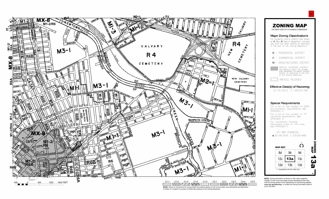
Major Zoning Classifications:The number(s) and/or letter(s) that follows
use, bulk and other controls as described
in the text of the Zoning Resolution.
an or District designation indicatesR, C M
12-10-2012 C 100218 ZMK
Effective Date(s) of Rezoning:
CL
CITY MAP CHANGE(S):02-28-2015 C 070109 MMQ
NOTE: Zoning information as shown on this map is subject tochange. For the most up-to-date zoning information for this map,visit the Zoning section of the Department of City Planning website:www.nyc.gov/planning or contact the Zoning Information Desk at(212) 720-3291.NOTE: Where no dimensions for zoning district boundaries appear on the zoning maps, such dimensions are determined
in Article VII, Chapter 6 (Location of District Boundaries) of the Zoning Resolution.
600 0 600 1200 1800 FEET C1-1 C1-2 C1-3 C1-4 C1-5 C2-1 C2-2 C2-3 C2-4 C2-5
For Inclusionary Housing
designated areas and Mandatory
Inclusionary Housing areas on this
map, see APPENDIX F.
For a list of lots subject to "D"restrictive declarations, seeAPPENDIX D.
For a list of lots subject to CEQR
environmental requirements, seeAPPENDIX C.
Special Requirements:
- RESIDENTIAL DISTRICT
- COMMERCIAL DISTRICT
- MANUFACTURING DISTRICT
AREA(S) REZONED
R
C
M
SPECIAL PURPOSE DISTRICT
The letter(s) within the shaded area designates the special purposedistrict as described in the text
of the Zoning Resolution.
8d 9d
12c 13c
12d 13b 13d
9b
Disclaimer
The Web version of the Zoning Resolution of the City of New York is provided for reference and the convenience of having the Resolution in an online format. Recent amendments to the Zoning Resolution also appear on the Web prior to being incorporated into the print version of the Resolution.

13a
13aZ
ON
ING
MA
P
MAP KEY
N
Copyrighted by the City of New Yorkc
ST.
ST.
BOX
AVE.
AVE.
HAVEMEYER
FROST
RICHARDSONST. CONO STRADA
RICHARDSON
ENGERT
NEWTON
WITHERS ST.WITHERS
150
MT. CARMEL
ST.
UNION
ST.607
M1-2/R6M1-2/R6A
300
M1-2R6
M1-2/
M1-2
M1-2/
M1-2/R6A
R6A
R6BM1-2/
ST.
ST.
M1-2/
M1-2/R
6A R6B
ST.
M1-2/R6A
ST.
NASSAUST.
100
100100
100100
100
100
100
100
MX
-8
MX-8
MX-8
100
100
M1-2/250
100
100
ST.
C
MEEKER
L
CLASH
COMMERCIAL
ST.
PROL.
N. 11 TH
R6A
M1-2/R6
ST.
HERBERT
BAYARDST.
SQ.
R6B
ST.
ROEBLING
N. 7 TH
ST.
ST.
N. 8 TH
ST.
ST.
N. 12 TH
BERRYAVE.
N. 15 TH
ST.
ST.
AVE.
ST.
CLAY
R6B
R7A
86
M1-2/
100
JACKSON ST.
OUR LADYOF THESNOWS SQ.
PARK
100
ST.
ST.
ST.
ST.
AVE.
GREENPOINT
ST.-GREENGEORGE APEN
ST.
AVE.
DRIGGS
AVE.
ST.
FIDELITY
ST.
AVE.
PULASKILEONARD
ST.
100
100
100
100
100
100
60
50
85
120
50
CL
KINGSLAND
OLIVE ST.
LORIMER
STUDZINSKIFATHER
SQ.
EXPWY
75
CL
100 100
BLVD.
100
100 100
150
100
CLCL
CL
CL
100100
100
100
100
CL
100
75100
75
75100
75100
100
100100
100
100100
100
R6
R6B
R6A
R7A
R6A
R6B
R6B
C4-3A
R6B
R6B
R7A
R6
R6BR6A
R6A
R6B
R6B
100
250
CLCL
150
125
80
70
McGUINNESS
BRIDGE
100
75
100
100
CL
R6A
MILTON
CL
M1-2/R6
ST.
ST.
ST.
100
ST.
KENT
JAVA
INDIA
HURON
GREEN ST.
GREENFREEMAN
EAGLE
DUPONT
PAIDGE
AVE.MANHATTAN
AVE.MANHATTAN
100
100
170
DEBEVOISE
AVE.
MORGAN
AVE.
MASPETH
AVE.
DRIGGS
AVE.
KINGSLANDNORTH
HENRY
ST.BEDFORD
R6A
R6
AVE. -GRANDPARENTS
AVE.
QUEENS
BROOKLYN
KOSCIUSZKO
BRID
GE
RUSSELL
VAN DAM
BANKER
ST.
R6B
R6A
WYTHE
WALESA-SOLIDARITY
SQUARE
MEM. PK.
AVE.GUERNSEY
NORTH HENRY
ST.
R6B
R6B
AVE.
N. 10 TH
THOMAS ST.
THOMASST.
M1-2/R6
ZONING MAPTHE NEW YORK CITY PLANNING COMMISSION
Major Zoning Classifications:The number(s) and/or letter(s) that follows
use, bulk and other controls as described
in the text of the Zoning Resolution.
an or District designation indicatesR, C M
12-10-2012 C 100218 ZMK
Effective Date(s) of Rezoning:
CL
CITY MAP CHANGE(S):06-08-2016 C 110254 MMK
NOTE: Zoning information as shown on this map is subject tochange. For the most up-to-date zoning information for this map,visit the Zoning section of the Department of City Planning website:www.nyc.gov/planning or contact the Zoning Information Desk at(212) 720-3291.NOTE: Where no dimensions for zoning district boundaries appear on the zoning maps, such dimensions are determined
in Article VII, Chapter 6 (Location of District Boundaries) of the Zoning Resolution.
600 0 600 1200 1800 FEET C1-1 C1-2 C1-3 C1-4 C1-5 C2-1 C2-2 C2-3 C2-4 C2-5
For Inclusionary Housing
designated areas and Mandatory
Inclusionary Housing areas on this
map, see APPENDIX F.
For a list of lots subject to "D"restrictive declarations, seeAPPENDIX D.
For a list of lots subject to CEQR
environmental requirements, seeAPPENDIX C.
Special Requirements:
- RESIDENTIAL DISTRICT
- COMMERCIAL DISTRICT
- MANUFACTURING DISTRICT
AREA(S) REZONED
R
C
M
SPECIAL PURPOSE DISTRICT
The letter(s) within the shaded area designates the special purposedistrict as described in the text
of the Zoning Resolution.
8d 9d
12c 13c
12d 13b 13d
9b
02-28-2015 C 070109 MMQ
Disclaimer
The Web version of the Zoning Resolution of the City of New York is provided for reference and the convenience of having the Resolution in an online format. Recent amendments to the Zoning Resolution also appear on the Web prior to being incorporated into the print version of the Resolution.

13a
13aZ
ON
ING
MA
P
MAP KEY
N
Copyrighted by the City of New Yorkc
ST.
ST.
BOX
AVE.
AVE.
HAVEMEYER
FROST
RICHARDSONST. CONO STRADA
RICHARDSON
ENGERT
NEWTON
WITHERS ST.WITHERS
150
MT. CARMEL
ST.
UNION
ST.607
M1-2/R6M1-2/R6A
300
M1-2R6
M1-2/
M1-2
M1-2/
M1-2/R6A
R6A
R6BM1-2/
ST.
ST.
M1-2/
M1-2/R
6A R6B
ST.
M1-2/R6A
ST.
NASSAUST.
100
100100
100100
100
100
100
100
MX
-8
MX-8
MX-8
100
100
M1-2/250
100
100
ST.
C
MEEKER
L
CLASH
COMMERCIAL
ST.
N. 11 TH
R6A
M1-2/R6
ST.
HERBERT
BAYARDST.
SQ.
R6B
ST.
ROEBLING
N. 7 TH
ST.
ST.
N. 8 TH
ST.
ST.
N. 12 TH
BERRYAVE.
N. 15 TH
ST.
ST.
AVE.
ST.
CLAY
R6B
R7A
86
M1-2/
100
JACKSON ST.
OUR LADYOF THESNOWS SQ.
PARK
100
ST.
ST.
ST.
ST.
AVE.
GREENPOINT
ST.-GREENGEORGE APEN
ST.
AVE.
DRIGGS
AVE.
ST.
FIDELITY
ST.
AVE.
PULASKILEONARD
ST.
100
100
100
100
100
100
60
50
85
120
50
CL
KINGSLAND
OLIVE ST.
LORIMER
STUDZINSKIFATHER
SQ.
EXPWY
75
CL
100 100
BLVD.
100
100 100
150
100
CLCL
CL
CL
100100
100
100
100
CL
100
75100
75
75100
75100
100
100100
100
100100
100
R6
R6B
R6A
R7A
R6A
R6B
R6B
C4-3A
R6B
R6B
R7A
R6
R6BR6A
R6A
R6B
R6B
100
250
CLCL
150
125
80
70
McGUINNESS
BRIDGE
100
75
100
100
CL
R6A
MILTON
CL
M1-2/R6
ST.
ST.
ST.
100
ST.
KENT
JAVA
INDIA
HURON
GREEN ST.
GREENFREEMAN
EAGLE
DUPONT
PAIDGE
AVE.MANHATTAN
AVE.MANHATTAN
100
100
170
DEBEVOISE
AVE.
MORGAN
AVE.
MASPETH
AVE.
DRIGGS
AVE.
KINGSLANDNORTH
HENRY
ST.BEDFORD
R6A
R6
AVE. -GRANDPARENTS
AVE.
QUEENS
BROOKLYN
KOSCIUSZKO
BRID
GE
RUSSELL
VAN DAM
BANKER
ST.
R6B
R6A
WYTHE
WALESA-SOLIDARITY
SQUARE
MEM. PK.
AVE.GUERNSEY
NORTH HENRY
ST.
R6B
R6B
AVE.
N. 10 TH
THOMAS ST.
THOMASST.
M1-2/R6
ZONING MAPTHE NEW YORK CITY PLANNING COMMISSION
Major Zoning Classifications:The number(s) and/or letter(s) that follows
use, bulk and other controls as described
in the text of the Zoning Resolution.
an or District designation indicatesR, C M
12-10-2012 C 100218 ZMK
Effective Date(s) of Rezoning:
CL
CITY MAP CHANGE(S):06-08-2016 C 110254 MMK
NOTE: Zoning information as shown on this map is subject tochange. For the most up-to-date zoning information for this map,visit the Zoning section of the Department of City Planning website:www.nyc.gov/planning or contact the Zoning Information Desk at(212) 720-3291.NOTE: Where no dimensions for zoning district boundaries appear on the zoning maps, such dimensions are determined
in Article VII, Chapter 6 (Location of District Boundaries) of the Zoning Resolution.
600 0 600 1200 1800 FEET C1-1 C1-2 C1-3 C1-4 C1-5 C2-1 C2-2 C2-3 C2-4 C2-5
For Inclusionary Housing
designated areas and Mandatory
Inclusionary Housing areas on this
map, see APPENDIX F.
For a list of lots subject to "D"restrictive declarations, seeAPPENDIX D.
For a list of lots subject to CEQRenvironmental requirements, seeAPPENDIX C.
Special Requirements:
- RESIDENTIAL DISTRICT
- COMMERCIAL DISTRICT
- MANUFACTURING DISTRICT
AREA(S) REZONED
R
C
M
SPECIAL PURPOSE DISTRICT
The letter(s) within the shaded area designates the special purposedistrict as described in the text
of the Zoning Resolution.
8d 9d
12c 13c
12d 13b 13d
9b
02-28-2015 C 070109 MMQ
250
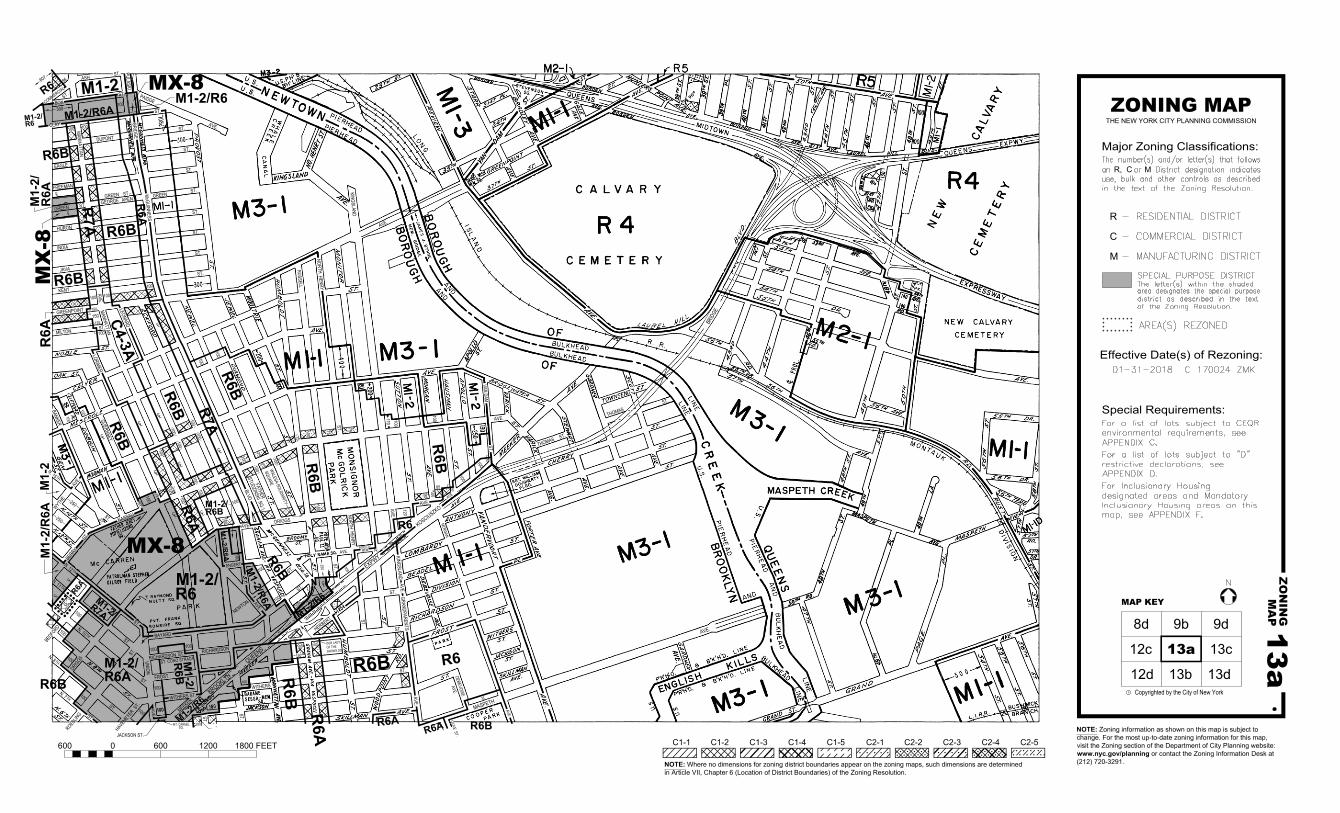
AS CORRECTED 10-04-2017
13a
13aZ
ON
ING
MA
P
MAP KEY
N
Copyrighted by the City of New Yorkc
ST.
ST.
BOX
AVE.
AVE.
HAVEMEYER
FROST
RICHARDSONST. CONO STRADA
RICHARDSON
ENGERT
NEWTON
WITHERS ST.WITHERS
150
MT. CARMEL
ST.
UNION
ST.607
M1-2/R6M1-2/R6A
300
M1-2R6
M1-2/
M1-2
M1-2/
M1-2/R6A
R6A
R6BM1-2/
ST.
ST.
M1-2/
M1-2/R
6A R6B
ST.
M1-2/R6A
ST.
NASSAUST.
100
100100
100100
100
100
100
100
MX
-8
MX-8
MX-8
100
100
M1-2/250
100
100
ST.
MEEKER
CL
ASH
COMMERCIAL
ST.
N. 11 TH
R6A
M1-2/R6
ST.
HERBERT
BAYARDST.
SQ.
R6B
ST.
ROEBLING
N. 7 TH
ST.
ST.
N. 8 TH
ST.
ST.
N. 12 TH
BERRYAVE.
N. 15 TH
ST.
ST.
AVE.
ST.
CLAY
R6B
R7A
86
M1-2/
100
JACKSON ST.
OUR LADYOF THESNOWS SQ.
PARK
100
ST.
ST.
ST.
ST.
AVE.
GREENPOINT
ST.-GREENGEORGE APEN
ST.
AVE.
DRIGGS
AVE.
ST.
FIDELITY
ST.
AVE.
PULASKILEONARD
ST.
100
100
100
100
100
100
60
50
85
120
50
CL
KINGSLAND
OLIVE ST.
LORIMER
STUDZINSKIFATHER
SQ.
EXPWY
75
CL
100 100
BLVD.
100
100 100
150
100
CLCL
CL
CL
100100
100
100
100
CL
100
75100
75
75100
75100
100
100100
100
100100
100
R6
R6B
R6A
R7A
R6A
R6B
R6B
C4-3A
R6B
R6B
R7A
R6
R6BR6A
R6A
R6B
R6B
100
250
CLCL
150
125
80
70
McGUINNESS
BRIDGE
100
75
100
100
CL
R6A
MILTON
CL
M1-2/R6
ST.
ST.
ST.
100
ST.
KENT
JAVA
INDIA
HURON
GREEN ST.
GREENFREEMAN
EAGLE
DUPONT
PAIDGE
AVE.MANHATTAN
AVE.MANHATTAN
100
100
170
DEBEVOISE
AVE.
MORGAN
AVE.
MASPETH
AVE.
DRIGGS
AVE.
KINGSLANDNORTH
HENRY
ST.
R6A
R6
AVE. -GRANDPARENTS
AVE.
QUEENS
BROOKLYN
KOSCIUSZKO
BRID
GE
RUSSELL
VAN DAM
BANKER
ST.
R6B
R6A
WYTHE
WALESA-SOLIDARITY
SQUARE
MEM. PK.
AVE.GUERNSEY
NORTH HENRY
ST.
R6B
R6B
AVE.
N. 10 TH
THOMAS ST.
THOMASST.
M1-2/R6
ZONING MAPTHE NEW YORK CITY PLANNING COMMISSION
Major Zoning Classifications:The number(s) and/or letter(s) that follows
use, bulk and other controls as described
in the text of the Zoning Resolution.
an or District designation indicatesR, C M
01-31-2018 C 170024 ZMK
Effective Date(s) of Rezoning:
CL
NOTE: Zoning information as shown on this map is subject tochange. For the most up-to-date zoning information for this map,visit the Zoning section of the Department of City Planning website:www.nyc.gov/planning or contact the Zoning Information Desk at(212) 720-3291.NOTE: Where no dimensions for zoning district boundaries appear on the zoning maps, such dimensions are determined
in Article VII, Chapter 6 (Location of District Boundaries) of the Zoning Resolution.
600 0 600 1200 1800 FEET C1-1 C1-2 C1-3 C1-4 C1-5 C2-1 C2-2 C2-3 C2-4 C2-5
For Inclusionary Housing
designated areas and Mandatory
Inclusionary Housing areas on this
map, see APPENDIX F.
For a list of lots subject to "D"restrictive declarations, seeAPPENDIX D.
For a list of lots subject to CEQRenvironmental requirements, seeAPPENDIX C.
Special Requirements:
- RESIDENTIAL DISTRICT
- COMMERCIAL DISTRICT
- MANUFACTURING DISTRICT
AREA(S) REZONED
R
C
M
SPECIAL PURPOSE DISTRICT
The letter(s) within the shaded area designates the special purposedistrict as described in the text
of the Zoning Resolution.
8d 9d
12c 13c
12d 13b 13d
9b
250
CL
BEDFORD
100
Metadata for Historical Zoning Maps:
Source:These PDF maps were created from the set of past versions of each of the 126 zoning maps in the Technical Review Division’s archive. This set includes map versions for each zoning map beginning with the original 1961 issue of the Zoning Resolution and ending with the current zoning map as posted in the Zoning section of the Department of City Planning website: www.nyc.gov/planning. Scanning and Creation of Adobe PDF copies:Maps in this archive from 1961 through Update #2 of the Zoning Resolution in 2003 are scans of actual printed zoning map. From Update #3 (2005) onwards, maps are direct PDF copies of the map revisions as printed in updates to the Zoning Resolution.
Notes on conversion of Amendment Numbers to CP (City Planning) or ULURP numbers:On earlier zoning maps, an Amendment Number (e.g. A-629) is used to identify the area that has been rezoned. Commission reports and sketch maps for rezonings are referenced solely by CP or ULURP numbers. In order to request copies of reports or sketch maps it is necessary to know the CP or ULURP number. A conversion table (ANumber-CPNumberConversion.pdf) is available to translate the “A” numbers listed on the actual zoning maps to their corresponding CP or ULURP numbers. Use of the Amendment Number to identify zoning map changes has been discontinued.
Copyright:These maps are copyrighted by the City of New York. This is indicated in the space below the map legend on each map.
Contact Info:NYC Department of City Planning22 Reade Street, RM 3NNew York, NY 10007212.720.3505 [email protected]
revised 02/11/11